Practice and Guidance note - Practice and ...
←
→
Page content transcription
If your browser does not render page correctly, please read the page content below
Auckland Unitary Plan

Practice and Guidance note
River/ Stream Classification
This Practice and Guidance Note (PGN) sets out criteria and processes to classify whether
rivers and streams, are permanent, intermittent or ephemeral. Correct classification of
rivers and streams is essential to correctly apply the provisions of the National Policy
Statement – Freshwater Management 2020 (Freshwater NPS), the Resource
Management (National Environmental Standards for Freshwater) Regulations 2020 (NES-
F) and the Auckland Unitary Plan (Operative in Part) (AUP(OP)), in particular Chapter E3,
Lakes, Rivers, Streams and Wetlands.

1. Introduction
2. Key message to resource consent applicants
3. Application of this Practice and Guidance Note
4. Terminology and Definitions
5. River/ Stream Assessment Approach
6. River/ Stream classification using the AUP(OP) criteria
     Appendix 1 Modelled river / stream classification
     Appendix 2 Additional sources of information for classification of rivers/streams
     Appendix 3 Relevant Definitions

Disclaimer
     The information in this practice and guidance note is, according to Auckland Council’s best efforts, accurate at
     the time of publication. Auckland Council makes every reasonable effort to keep it current and accurate.
     However, users of the practice and guidance note are advised that:

     •    the information provided does not alter the Auckland Unitary Plan, Auckland Council District Plan -
          Hauraki Gulf Islands Section, Resource Management Act 1991 or other laws of New Zealand and other
          official guidelines and requirements

     •    this document sets out general principles which may be used as guidance for matters relating to the
          interpretation and application of the Auckland Unitary Plan; it is not intended to interfere with, or fetter,
          the professional views and opinions of council officers when they are performing any function or
          exercising any power under the RMA. Each consent will be considered on a case-by-case basis and on
          its own merits

     •    Users should take specific advice from qualified professional people before undertaking any action as a
          result of information obtained in this practice and guidance note

     •    Auckland Council does not accept any responsibility or liability whatsoever whether in contract, tort,
          equity or otherwise for any action taken as a result of reading or reliance placed on Auckland Council
          because of having read any part, or all, of the information in this practice and guidance note or for any
          error, or inadequacy, deficiency, flaw in or omission from the information provided in this publication.

Page 1 of 23                                         July 2021                                       RC 3.3.17 (V2)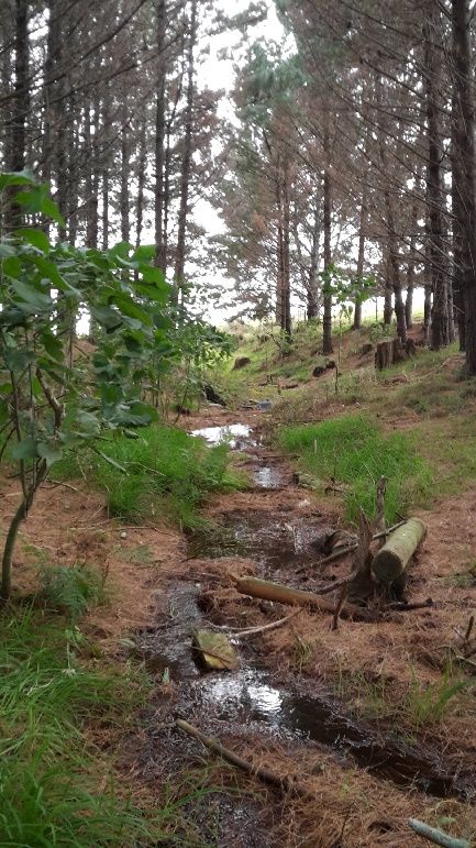
1        Introduction

The Resource Management Act 1991 (RMA) defines “river” as being continually or
intermittently flowing body of freshwater. The National Policy Statement –
Freshwater Management 2020 (Freshwater NPS), the Resource Management
(National Environmental Standards for Freshwater) Regulations 2020 (NES-F) and
the Auckland Unitary Plan (Operative in Part) (AUP(OP)) include provisions for the
management of permanent and intermittent rivers and streams. To achieve the
outcomes of these statutory documents as they apply to rivers and streams, people
must identify whether a river or stream is permanent, intermittent, or ephemeral in
order to understand which rules apply.

This Practice and Guidance Note (PGN) sets out processes to identify whether rivers
or streams are permanent, intermittent or ephemeral, and importantly to enable
persons to determine the point where a river or stream transitions from ephemeral to
intermittent.

For further guidance, please refer to the “Essential Freshwater Policies &
Regulations” section of the Auckland Design Manual.

2        Key message to resource consent applicants

Auckland is characterised by small rivers and streams. Intermittent rivers and
streams can be difficult to identify and locate. This is especially true in modified
environments. If works are being proposed and a river or stream may be present,
expert advice should be taken to determine the nature of that river or stream and to
determine what provisions apply.

3        Application of this Practice and Guidance Note

Identifying whether rivers or streams are permanent, intermittent or ephemeral is a
technical matter and persons classifying rivers and streams must be suitably
qualified and experienced practitioners (SQEP). The National Environmental

Page 2 of 23                           July 2021                         RC 3.3.17 (V2)
Standard guidelines 1 recommend that such an individual would possess the
following qualifications:

•   Relevant professional experience relating to freshwater ecology, assessment
    and the ability to undertake independent ecological evaluations (preliminary
    investigations)
•   At least tertiary level education in ecology, environmental science or a related
    field, with one or more years of professional experience in freshwater ecological
    evaluations (detailed investigations)
At council’s discretion and on a case by case basis, the council may request that the
report produced by the SQEP in support of the classification, is also certified by a
senior or principal freshwater ecologist.

4         Terminology and Definitions

This PGN uses the terms ‘rivers’ and ‘streams’ interchangeably when referring to
permanent and intermittent flowing bodies of freshwater. This reflects the mix of
terms on the definitions of the RMA and the AUP(OP).
The RMA defines river as:

        A continually or intermittently flowing body of fresh water; and includes a
        stream and modified watercourse; but does not include any artificial
        watercourse (including an irrigation canal, water supply race, canal for the
        supply of water for electricity power generation, and farm drainage canal)

The AUP(OP) refers to both rivers and streams. The AUP(OP) in Chapter J defines
rivers and stream types as:

        River or stream

        A continually or intermittently flowing body of fresh water, excluding
        ephemeral streams, and includes a stream or modified watercourse; but does
        not include any artificial watercourse (including an irrigation canal, water
        supply race, canal for the supply of water for electricity power generation, and
        farm drainage canal except where it is a modified element of a natural
        drainage system).

1MfE. 2012. Users’ Guide National Environmental Standard for Assessing and Managing Contaminants in Soil to
Protect Human Health. Wellington: Ministry for the Environment.
Page 3 of 23                                    July 2021                                  RC 3.3.17 (V2)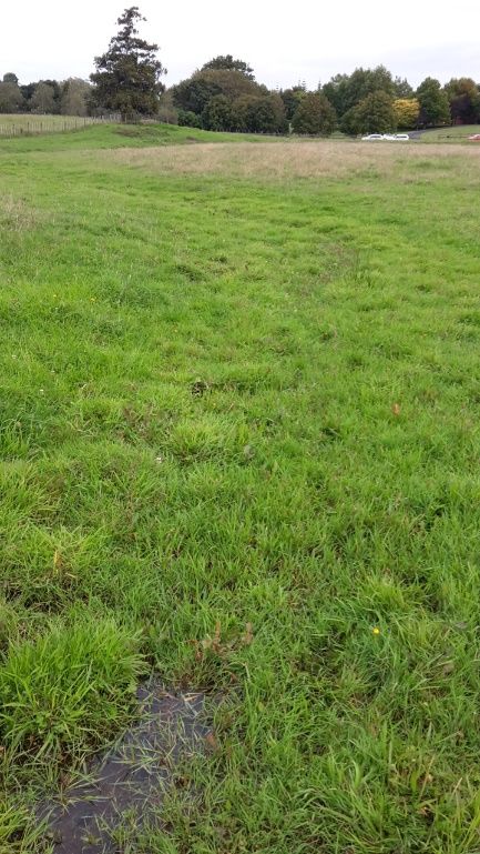
Permanent river or stream

       The continually flowing reaches of any river or stream.

       Intermittent stream

       Stream reaches that cease to flow for periods of the year because the bed is
       periodically above the water table. This category is defined by those stream
       reaches that do not meet the definition of permanent river or stream and meet
       at least three of the following criteria:
           a) it has natural pools
           b) it has a well-defined channel, such that the bed and banks can be
              distinguished
           c) it contains surface water more than 48 hours after a rain event which
              results in stream flow
           d) rooted terrestrial vegetation is not established across the entire cross-
              sectional width of the channel
           e) organic debris resulting from flood can be seen on the floodplain or
           f) there is evidence of substrate sorting process, including scour and
              deposition.
       Ephemeral stream

       Stream reaches with a bed above the water table at all times, with water only
       flowing during and shortly after rain events. This category is defined as those
       stream reaches that do not meet the definition of permanent river or stream or
       intermittent stream.

Also see Appendix 3 Relevant national and regional definitions.

5        River/ Stream Assessment Approach

5.1 Non-survey / desktop analysis
The first step is a non-survey/desktop analysis. The following should be used (when
available) to improve confidence in drainage system classifications:

•   Existing GIS data and tools (e.g., GeoMaps, Overland Flow Path layer, Modelled
    stream layer)
•   Existing site data (local, regional and national datasets)

Page 4 of 23                            July 2021                          RC 3.3.17 (V2)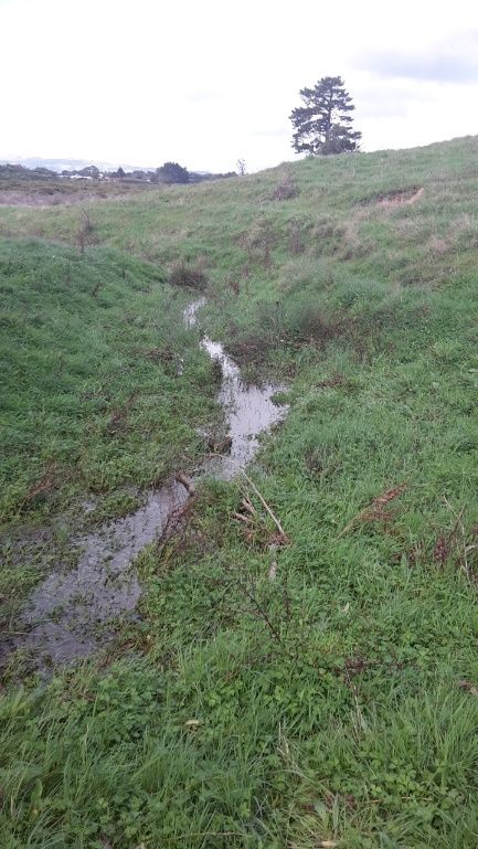
•     Modelled data
•     Current and historic aerial photography
•     Existing literature
•     Use local knowledge as much as possible (upstream, downstream, on-site,
      knowledge of previous years, photographs from the landowner)
•     Understand relationships between drainage features and topography on the site
      and in the catchment
Some of the available information sources are provided in Appendix 1 and 2. This
information should be included with the assessment.

The SQEP should be aware of any new tools that are developed over time and have
the ability to use them.

5.2      Field survey
The second step is a field survey. The first matter to consider when on site is
whether the watercourse has evidence of intermittently or permanently flowing water.
Clear evidence of extended periods of surface water or base flow in a watercourse
include:

•     Aquatic macroinvertebrates presence
•     Obligate of facultative wetland or aquatic vegetation presence
•     Algal growths
•     Anaerobic / hydric soil presence
•     Presence of a spring (hard to observe in summer)
•     Fish species presence
•     Historical evidence (e.g., fish records and historical flow data – prolonged flows)
If the watercourse exhibits some or all of the above features, then it is considered to
be, at a minimum, an intermittent river.

Whilst it is possible for classification to be carried out at any time of the year,
assessment confidence is highest in the wet season, particularly when assessing
intermittent rivers and streams. River and stream classification assessments are best
undertaken between July and October2 when ecological functioning can be most
accurately assessed. Assessment in the wet season may increase the uncertainty or
difficulty of determining whether the watercourse is permanent or intermittent

2
 Neale, M W., Storey, R G and Quinn, J L (2016). Stream Ecological Valuation: application to intermittent
streams. Prepared by Golder Associates (NZ) Limited for Auckland Council. Auckland Council technical report,
TR2016/023.

Page 5 of 23                                      July 2021                                   RC 3.3.17 (V2)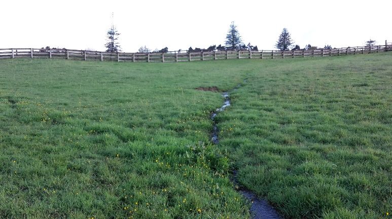
classification, however, the key requirement for the NES-F and the AUP(OP), is the
distinction between ephemeral and intermittent.

If initial assessments cannot be undertaken during the wet season it is possible to
classify rivers and streams outside of these months. However, if conclusions cannot
be formed with confidence, the watercourse should be considered intermittent until a
follow up assessment can be completed in the wet season or an alternative method
of classifying the watercourse can be agreed with council.

When undertaking a field-based assessment, the SQEP should apply the following:

•     Familiarise itself with the catchment drainage system in the area. Before going to
      site, note the catchment drainage system in terms of its size and any modelled
      overland flow path status 3 (available on GeoMaps), and use this as a high-level
      indication of the point of origin of the rivers onsite.
•     The modelled overland flow path extent has generally shown a good correlation
      with survey data in instances where groundwater tables have not been artificially
      lowered. However, the modelled data should be treated as indicative only. It is
      recommended the actual extent of watercourses are obtained during the site
      inspection / field survey.
•     Go to the site with the outcomes of the non-survey / desktop outcomes in mind
      and annotated on maps.
•     Walk down from the top of the catchment and walk all tributaries; if the
      catchment extends beyond the property, assess the drainage system above and
      below the property in question to better understand the drainage features on the
      property.
•     Walk over remainder of the site to determine if any offline wetlands are present
      (i.e., those wetlands not immediately associated with a river network).
•     The assessment should not be spatially limited to any specific property, as rivers
      are connected systems and individual reaches cannot be considered in isolation.
•     Assess drainage features that are visible at that time of year and that can be
      assessed with high confidence.
•     Where high confidence predictions can be made, include these in the
      assessment (including assumptions).
•     Compensate for levels of land use disturbance / anthropogenic impact.
•     Consider factors such as preceding rainfall4 in comparison to the long-term
      rainfall mean and seasonality of the high water table. Local rainfall gauges
      should be detected to determine the volume and time since the last rainfall.
      Where flow gauges are available, these will also provide useful information.

3 Storey R and Wadhwa S (2009). An assessment of the length of permanent, intermittent and ephemeral streams in the Auckland
Region. Prepared by NIWA for Auckland Regional Council. Auckland Regional Council Technical Report 2009/028.
Whilst this study was primarily undertaken to assess the length of different streams classes (permanent, intermittent and ephemeral)
within the Auckland region, it is the best currently available tool for predicting the presence or absence of streams.
4 Rainfall data can be obtained from Auckland Council GeoMaps (Hydstra data) for the nearest rainfall monitoring station.

Page 6 of 23                                                  July 2021                                              RC 3.3.17 (V2)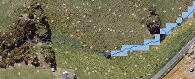
•   Where livestock have had an impact on the watercourse, assess areas where
      stock have not had access immediately upstream or downstream of the site if
      possible, and carry out comparative assessments within less impacted areas as
      close as possible to the catchment. The assessment must not be made by
      observing one point, but rather should be made by observing the entire reach
      and upstream and downstream (where practicable).

  6        River/ Stream Classification using AUP (OP) criteria

  The third step is to assess the information gathered against the criteria set out in the
  AUP(OP) definition of permanent, intermittent and ephemeral river and stream.
  Whilst these do not apply to the NES-F, in the absence of other direction, these
  would form best practice guidance.

  Permanent rivers are distinguished from intermittent and ephemeral streams by
  having continually flowing water year-round. However, due to the periodic nature of
  both intermittent and ephemeral streams, the process of distinguishing between
  these is more complex. Table 1 below sets out the criteria from the AUP (OP)
  definitions:
  Table 1: AUP(OP) criteria for permanent, intermittent rivers and streams and ephemeral streams

          Criterion                     Definition
Permanent river or stream
                  1                     Evidence of continuous flow
Intermittent river or stream, or ephemeral stream
Ceases to flow when bed is above water table. To be intermittent, a river must exhibit at least 3
of the following
                  1                     Evidence of natural pools
                  2                     Well defined channel. Banks and bed can be distinguished
                  3                     Surface water present (more than 48hrs after a rain event)
                  4                     Rooted terrestrial vegetation not present across the entire
                                        cross-sectional width of channel
                  5                     Organic debris present in floodplain
                  6                     Evidence of substrate sorting processes, including scour
                                        and deposition
Ephemeral stream
                  1                     Stream bed above the water table at all times.
                  2                     Water present only during and shortly after rain fall

  Page 7 of 23                                   July 2021                                RC 3.3.17 (V2)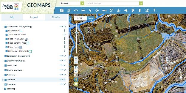
6.1 Permanent and intermittent rivers and streams
The first matter to consider when on site is whether the watercourse has evidence of
intermittently or permanently flowing water. Clear evidence of extended periods of
surface water or base flow in a watercourse includes:

•   Aquatic macroinvertebrates presence
•   Obligate of facultative wetland or aquatic vegetation presence
•   Algal growths
•   Anaerobic / hydric soil presence
•   Presence of a spring (hard to observe in summer)
•   Fish species presence
•   Historical evidence (e.g., fish records and historical flow data – prolonged flows)
If the watercourse exhibits some or all the above features, then it is considered to be,
at a minimum, an intermittent river.

6.2 Intermittent and ephemeral rivers and streams
Determining whether a river or stream is intermittent or ephemeral can be
challenging. The defining distinction between intermittent and ephemeral streams is
that ephemeral streams always have a bed above the water table and only hold
flowing water during and shortly after rain events. In contrast, the prolonged
presence of water in the bed is a clear factor for intermittent streams.

The best time to make this determination is winter when the seasonal groundwater
table is at its highest and intersects with the bed. If there is significant uncertainty in
classification during the dry season, then the assessment should be re-done in
winter, with a precautionary approach adopted in the intervening period (being the
classification as an intermittent watercourse).

The following process provides a guideline for determining the status of a natural
watercourse:

•   Question 1: Is there flowing water year-round or flowing water present in the
    height of summer? If yes, then it is a permanent river or stream. Do not consider
    subsequent questions. If no, then the watercourse is either intermittent or
    ephemeral.
•   Question 2: Is the bed below the water table at any time? If yes, then it is an
    intermittent river or stream. If no, then it is an ephemeral stream. If Question 2
    cannot be assessed due to seasonality or uncertainty, then you must consider
    Question 3.

Page 8 of 23                              July 2021                            RC 3.3.17 (V2)
• Question 3: Can at least 3 out of 6 criteria in the intermittent stream definition be
assessed with sufficient confidence? If no, then a wet season survey is required.
If yes, then consider Question 4.
• Question 4: Are at least 3 of the 6 criteria in the intermittent stream definition
met? If the answer to Question 3 is yes, then it is an intermittent river or stream.
If no, then it is an ephemeral stream.
The definition of intermittent stream in the AUP (OP) includes six criteria used in
determining whether a stream is intermittent. A diagrammatic representation of the
assessment process is provided in Section 6.4. It is recognised that there are some
limitations to the application of these criteria, therefore it is required that the applicant
engages a SQEP whom will exercise their experience and professional judgement
when undertaking the assessment.
Criterion 1 – Does the river/stream have natural pools?
• Cannot be assessed with confidence when the watercourse has been trampled
by livestock or where vegetation has grown across the watercourse during the
dry season reducing the visibility of pools. Where stock have had unrestricted
access, or where terrestrial vegetation has grown over the bed, pools may not be
present.
• Natural pools are easily identifiable during the wet season when filled with water
but may be more difficult to identify in the dry season.
• Pools retain water and the bed remains free of terrestrial vegetation for longer
periods between wet seasons. A pool does not require the presence of water to
be identifiable, and pool features can be assessed in the dry season.
• Pools must be easily distinguishable. Clear evidence it has formed by sustained
flows. This includes evidence of deposition in the base of the pool, an absence of
terrestrial plants, and connection to the streambed.
Criterion 2 – Is there a well-defined channel, such that the bed and banks can
be distinguished?
• Cannot be assessed with confidence when the watercourse has been trampled
by livestock or where terrestrial vegetation has grown over the bed in the dry
season.
• In impacted area, the bed should be clearly identifiable - a simple test involves
the following questions:
o Can I point to the bed?
o Can I point to the bank?
o Can I, with confidence, place one foot in the bed and the other on the bank;
and when I look down, can I clearly see the area where the change takes
place?
• There is an identifiable transitional area between the stream bed and banks. A
permanent river or stream is likely to have a narrow well-defined transitional area
Page 9 of 23 July 2021 RC 3.3.17 (V2)(‘point of inflexion’, where there is clearly a change in the angle of the stream
channel). An intermittent river or stream generally has a flat bed (however
narrow) that transitions abruptly into sloped banks. There is a clear change in
angle between the stream bed and the banks (a trapezoidal channel). An
ephemeral stream has an indistinct or wide transitional area. An ephemeral
stream generally has a concave or V-shaped channel.
• Sometimes there is no clear point of inflexion on both sides of the channel, such
as on the inside bend of a river or stream. A river or stream can, therefore, have
one bank–stream bed interface which is well-defined and still meet the test of
‘well-defined’. The presence of an active or relic floodplain is a good indicator of
channel processes.
Criterion 3 - It contains surface water more than 48 hours after a rain event
which results in stream flow
• This criterion cannot be assessed with confidence in dry conditions (i.e., summer
months, outside of July to October).
• This criterion can only be assessed if the watercourse is inspected shortly after a
suitable rainfall event that results in stream flow. In the absence of flow
monitoring data, a suitable rainfall event is at a magnitude of 12-70 mm and will
enable this criterion to be assessed with confidence. An inspection between 48
and 60 hours (2.5 days) after a suitable rainfall event is considered practically
acceptable, although the aim must be to visit the stream as close as possible to
the 48-hour threshold. The 48 hours is measured from the end of precipitation in
rain events shorter than 6 hours, or once 90% of the rain has fallen in rain events
longer than 6 hours.
• Surface water may be flowing water or still water in pools. Intermittent streams
regularly do not have flowing water, especially in their upper reaches. The depth
of the surface water is not important. Low volume and shallow flow are
characteristic of intermittent streams.
• Note: An inspection after 60 hours only serves to validate the presence of
surface water; it cannot be used to validate the absence of surface water.
• Rainfall data is best obtained from rain radar and the closest Auckland Council
rainfall gauges, which are available here: https://environmentauckland.org.nz/.
Due to the variability of rainfall events, it is recommended that multiple rainfall
events are surveyed. Auckland Council’s long-term monitoring data indicates that
seasonal base flows have returned in most intermittent streams during the period
beginning August to end of November.
• Factors to keep in mind when assessing this criterion:
o Surface water in intermittent rivers and streams is often disconnected, hidden
beneath vegetation, and may comprise very diffuse and shallow water. The
assessment must therefore include close-up examination of the bed, looking
beneath organic debris or overhanging vegetation where the bed is not
visible.
o Rivers and streams may also go underground for short lengths, and these
interceding sections comprise a functional component of the river/stream; to
Page 10 of 23 July 2021 RC 3.3.17 (V2)prevent a false negative, rivers/streams should be walked moving down from
the top of the catchment.
o Thin films of surface water may be absent in unshaded rivers/streams, whilst
being present in shaded sections of rivers/stream.
o Base flow may at times and at certain locations be under the surface, with
patches that have no surface flow.
o It is important to look upstream and downstream of the reach to determine
whether there is flowing water which may be absent from the subject reach.
Criterion 4 - Rooted terrestrial vegetation is not established across the entire
cross-sectional width of the channel
• Extremely difficult to assess with confidence from the end of October to July in
streams that are not forested or where stock impact is evident.
• Terrestrial vegetation is unable to survive prolonged periods of inundation. The
thalweg 5 of intermittent rivers and streams generally remains devoid of terrestrial
vegetation over the entire year in natural forested streams. However, at sites
where a watercourse is not shaded by forested riparian margins, terrestrial
vegetation tends to spread into intermittent river/stream channels as soon as
they start drying up. This can make identification of this criterion difficult.
• In the dry season it can be difficult to use the presence or absence of terrestrial
vegetation as a distinguishing feature between ephemeral and intermittent
watercourses (in rivers/streams without riparian margins).
• When conducting the assessment in the above conditions:
o Plants should be assessed as to whether they have spread into the stream
bed since the end of winter, or whether they are present year-round (i.e.
established).
o Dominance of the bed by annual plants or opportunistic perennial plants
(e.g., creeping grasses), is an indication that terrestrial plants are not
established.
o An absence of perennial tufted plants in the bed is an indication that
terrestrial vegetation is not established in the bed.
o Plants in the bed will generally have less fibrous root material than those on
the banks; the less fibrous the root mass the more likely the river/stream is
intermittent.
o Terrestrial plants rooted in the bank may spread into the river/stream and
obscure the stream thalweg5 / flow paths; it is necessary to lift up
overhanging vegetation to inspect thalwegs5 / flow paths.
5Thalweg definition: The longitudinal alignment of the lowest points along the entire length of a stream bed or
valley in its downward slope, defining its deepest channel. Not defined in the RMA or AUP(OP).
Page 11 of 23 July 2021 RC 3.3.17 (V2)• The presence of facultative wetland plant species (as per Clarkson et al 2013 6)
adjacent to or within the channel of a watercourse is an indication that the
river/stream is likely to be intermittent rather than ephemeral, and a wet season
survey is required for verification in such circumstances.
Criterion 5 - Organic debris from flood can be seen on the floodplain
• It is not possible to apply this criterion in situations where there are negligible
upstream sources of organic debris, livestock impacts are too great, or streams
are too incised to have a floodplain that floods regularly. Where organic debris
sources are not available, the presence of non-organic debris (e.g., plastics and
sediment) can be an indicator of the presence of an intermittent stream.
• The floodplain is the area outside of the stream bed and banks which is
inundated when the stream floods / ‘overbanks’ (flows are high enough so that
water spills out over its stream banks). The floodplain for an intermittent stream
is relatively narrow. Organic debris includes twigs, sticks, branches, logs, leaves
and other floating materials that have accumulated in the floodplain (up the bank,
on flooded areas, and on vegetation). Whilst woody debris persists, herbaceous
material degrades relatively quickly.
• The amount of debris accumulated is influenced by upstream catchment
characters, land use, sources of debris, and artificial changes to stream
morphology. This must be considered during the assessment, and the following
questions should be addressed:
o Is there an upstream source of woody organic debris?
o Is there an upstream source of herbaceous organic debris?
o Has there been a rainfall event within the past one or six months which
overbanked the channel, respectively in rivers/streams with pasture or tree
dominated upstream catchments?
o Is the floodplain protected from livestock?
o Is the floodplain protected from other land disturbances?
If the answer to the above questions is generally ‘no’, then it is unlikely that this
criterion can be applied with confidence.
Criterion 6 - There is evidence of substrate sorting processes, including scour
and deposition
• Cannot be assessed with confidence when the watercourse has been trampled
by livestock, or other land use has significantly transformed the stream.
• Intermittent streams have evidence of substrate 7 sorting due to prolonged flows
in the watercourse. Signs of bed forming processes are:
6 Clarkson BR, Champion PD, Rance BD, Johnson PN, Bodmin KA, Forester L, Gerbeaux P and Reeves PN.
2013. New Zealand wetland indicator status ratings. Hamilton: Landcare Research.
7
The material on the stream bottom, including organic and inorganic material
Page 12 of 23 July 2021 RC 3.3.17 (V2)o Variable sediment size aggregations in the bed and banks.
o Low quantities or the absence of humus in the watercourse.
o Distinct erosion and sedimentation patterns.
o Formation of sinuous channels, depositional bars, benching on the stream
bank, accumulated mud, scour pools, under-cuts, head-cuts, side-cuts, riffles,
alluvium, braided channels, and cascades.
• Substrate sorting is most visible in geologies that give rise to hard-bottomed
streams as opposed to soft-bottomed streams. Most of Auckland’s rivers/streams
are soft-bottomed and are comprised mostly of mud (fine sand and clay), and
substrate sorting processes are much more subtle. Furthermore, substrate
sorting is less evident in spring-fed rivers/streams and headwater rivers/streams,
and the assessment should be scaled to stream size / power.
Note
It is important to note that once a watercourse or river/stream reach has been
determined to be permanent, all downstream reaches from that point are considered
to be permanent. Similarly, once a river/stream reach has been determined to be
intermittent, all downstream reaches from that point are considered to be, at a
minimum, intermittent.
6.3 Factors complicating classification
Land use impacts can significantly affect the appearance and structure of
watercourses and wetlands, and subsequently the confidence level at which the
assessment can be completed. Land use impacts may make it difficult or impractical
to apply all of the criteria as described above all of the time. As such, the criteria
must be assessed in the context of the site.
Examples of the factors that may complicate the classification process are described
in Table 2 to provide an insight into the complexities of stream classification,
especially for differentiation between intermittent and ephemeral streams or
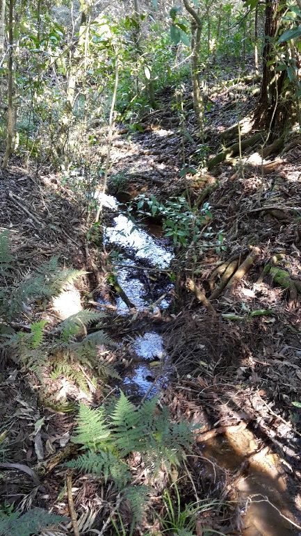
wetlands. Some images of intermittent streams are shown below to provide some
insight as to the challenges to classification. Potential solutions for overcoming these
issues are described in Section 6.2.
Table 2 does not provide a complete set of issues to be considered, but instead
provides an insight into the complexities of stream classification, especially for
differentiation between intermittent and ephemeral streams or wetlands.
Piped flows (including piped streams, pipes for land drainage and piped stormwater
networks) are generally not considered watercourses or wetlands, unless a natural
stream or wetland was piped or drained unlawfully. If the latter applies, then the
Page 13 of 23 July 2021 RC 3.3.17 (V2)relevant pipes and piped areas are classified in terms of what they would have been
prior to unlawful modification.
Culverts and piped streams (undertaken legally) continue to provide some (albeit a
small amount) of ecological function and contribute to maintaining catchment
hydrology. Despite not being ‘water’ while contained within the piped reach under the
RMA, these piped streams and culverts should be identified for the potential for them
to be daylighted.
Table 2: Examples of factors which may complicate classification of intermittent and ephemeral streams
and possible solutions for overcoming them.
Disturbance Potential impact Affected criterion
factor (refer to Section 7)
Livestock Difficulty identifying stream bed / banks Stream criterion 2
trampling / Removal of flood debris Stream criterion 5
access Removal of vegetation characteristics Stream criterion 4
Removes evidence of natural stream processes (i.e. Stream criterion 6
substrate sourcing)
Agricultural Pastural species can rapidly invade intermittent streams in Stream Criteria 1, 2,
land use summer compromising the ability to identify drainage features 3&4
Associated watercourses are often free of sediment and Stream criteria 4 & 6
weeds. This may eliminate vegetation and substrate
characteristics required for the assessment
Agricultural streams will often lack riparian margins, therefore Stream criterion 5
do not have a source of debris and so can result in no flood
debris being present.
Urban land use Increased imperviousness may increase surface runoff and Stream criterion 3
stream flow
Reduced infiltration may reduce ground and surface water Stream criteria 1 & 3
flow, which may lower base flows and shorter periods of
intermittent flow
Disruption to Constructed dams can alter surface water flow, making it Stream criteria 1 & 3
natural difficult to determine natural flow regimes
watercourse Upstream water takes can impact duration, frequency and Stream criteria 1, 3 &
flow severity of stream flow / flooding, the incidence of flood 5
debris
Watercourse Reduced connection to floodplain can make it difficult to Stream criterion 5
modification identify flood debris
Alteration of physical attributes Stream criteria 1 & 2
Clearance of Reduction of potential sources of flood debris Stream criterion 5
riparian
vegetation
Watercourse Smaller / intermittent streams will not always have evidence Stream criterion 5
size of flood debris
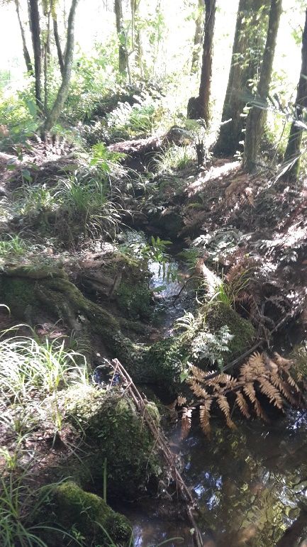
Page 14 of 23 July 2021 RC 3.3.17 (V2)Examples of intermittent streams where riparian margins are fairly intact and stream criterion can be easily assessed. Photographs taken when flow present, however even in dry season, most of the criterion can be assessed with confidence. Examples of streams where the bed and bank are not easily distinguishable due to land use and topography. In dry periods, stream channels in both sites become effectively absent and other criterion are difficult to assess with confidence. Page 15 of 23 July 2021 RC 3.3.17 (V2)
Example of streams where agricultural land use has significantly impacted the stream
 channel and subsequently makes classification of these systems difficult in dry season
 conditions. Terrestrial vegetation is present across the stream, due to stock damage, there
 is no upstream contributing organic debris and substrate sorting is absent. Catchment
 size, contours, evidence of flowing water more than 48 hours after rainfall and aerial
 imagery contributes to the classification of these streams. In dry season, these streams
 would not be identified, let alone assessed with confidence, and so a wet season
 assessment is essential.

Page 16 of 23                             July 2021                            RC 3.3.17 (V2)
6.4 Decision-Making Flow Chart – Stream Type

Page 17 of 23               July 2021          RC 3.3.17 (V2)
Appendix 1 Modelled river / stream classification

The findings of Storey and Wadwha 8 can be used as a general guide to identify the
transition between ephemeral and intermittent river/stream reaches. Whilst this study
was primarily undertaken to assess the length of different river/streams classes
(permanent, intermittent and ephemeral) within the Auckland region, it is the best
available tool for predicting the flow classification. Where land use has significantly
affected river/stream morphology, this transition point may be the point at which
wetlands have formed.

The Auckland Council overland flow path GIS layers are available for approximate
application of the Storey and Wadwha 9 catchment figures. These are currently
available on Auckland Council’s GeoMaps. Although high level, these do provide a
reasonable indication of river/stream status based on flow and should be a starting
point for all assessments.
Table 2 Average threshold contributing areas (i.e., the size of catchments where stream channels are
initiated); all values are in hectares

*Note: These figures may vary as modelled maps are updated.
Storey and Wadhwa predict that intermittent rivers/streams are formed when
catchments exceed 1.68 hectares in Waitemata sandstone areas; they also suggest
that intermittent rivers/streams are likely to originate above the extent of the
modelled floodplain. All these factors can be investigated using Auckland Council
GeoMaps overlays (overland flow path, floodplains and contributing catchment size)
and should be used as an initial step to determine stream status prior to fieldwork
(refer to Figures 1 to 3 below).

Auckland Council is currently working on an intermittent river/stream overlay that will
be made publicly available and incorporated into GIS mapping tools (e.g., GeoMaps)
once finalised. As such, it is important that applicants check the availability of this
tool prior to undertaking preliminary desktop assessments.

8   Above in 3
9   ditto
Page 18 of 23                                 July 2021                                RC 3.3.17 (V2)
Figures 1 to 3 provide examples of the layers and information available in existing
GeoMaps overlays.

        Figure 1: Auckland Council Geomaps layers: contours, streams and modelled floodplains (Ranui).

The red circle indicates an intermittant stream that is fed by a degraded wetland

           Figure 2: Auckland Council Geomaps layer tabs: catchment area and catchment overlays.

                                                                                                          Relevant
                                                                                                          Geomaps
                                                                                                           layers

                                                                                                          Contributing
                                                                                                           catchment
                                                                                                           areas (m2)

Page 19 of 23                                    July 2021                                     RC 3.3.17 (V2)
Figure 3: Close up of Ranui indicating how Auckland Council Geomaps layers can be used to determine the
approximate origin of an intermittent stream.
Modelled origin
of intermittent
stream
Page 20 of 23 July 2021 RC 3.3.17 (V2)Appendix 2 Additional sources of information for
classification of rivers and streams
The following may be considered (inter alia):
• Auckland Council GIS data including:
o Contours
o Flood plains
o Flood sensitive areas
o Flood prone areas
o Overland flow paths
o River names
o Catchment and Hydrology\ Water course assessment
• Fish surveys databases (e.g., NIWA)
• Auckland Council Watercourse Management Plans and Watercourse
Assessment Reports
• Catchment Management Plans and Network Discharge Consents
• River Environment Classification (REC)
• Existing site data (any relevant local, regional and national datasets)
• Historic aerial photography
• Existing literature
• Use local knowledge as much as possible (upstream, downstream, on site,
knowledge of previous years)
• A number of streams in the Auckland region have been surveyed; at the start of
a project enquire with Auckland Council as to whether any surveys have been
done for any specific property or stream, or upstream or downstream of the
stream
• Forested streams in adjacent catchments provide opportunities for comparative
assessments against degraded rural rivers/streams, improving confidence.
Note: Not all of the above may be accessible to the public, Council to assist where
required.
Page 21 of 23 July 2021 RC 3.3.17 (V2)Appendix 3 Relevant definitions
Table 3: RMA NPS Freshwater, NES-F and AUP(OP) definitions relevant to river and stream classification.
Freshwater
Legislation Definition
system
RMA
(Part 1, Section River A continually or intermittently flowing body of fresh water; and
2) includes a stream and modified watercourse; but does not include any
artificial watercourse (including an irrigation canal, water supply race,
canal for the supply of water for electricity power generation, and farm
drainage canal)
Water body Fresh water or geothermal water in a river, lake, stream, pond,
wetland, or aquifer, or any part thereof, that is not located within the
coastal marine area
NPS River Has the same meaning as in section 2 of the RMA
Freshwater and
NES-F
AUP(OP) River or Stream A continually or intermittently flowing body of fresh water; excluding
(Chapter J) ephemeral streams, and includes a stream or modified watercourse;
but does not include any
artificial watercourse (including an irrigation canal, water supply race,
canal for the supply of water for electricity power generation, and farm
drainage canal except where it is a modified element of a natural
drainage system).
Permanent river The continually flowing reaches of any river or stream
or stream
Intermittent Stream reaches that cease to flow for periods of the year because the
stream 10 bed is periodically above the water table. This category is defined by
those stream reaches that do not meet the definition of a permanent
river or stream and meet at least three of the following criteria (refer to
Section 6 for more detail):
a) it has natural pools
b) it has a well-defined channel, such that the bed and banks can be
distinguished
c) it contains surface water more than 48 hours after a rain event
which results in stream flow
d) rooted terrestrial vegetation is not established across the entire
cross-sectional width of the channel
e) organic debris resulting from flood can be seen on the floodplain
f) there is evidence of substrate sorting process, including scour
and deposition
Ephemeral Stream reaches with a bed above the water table at all times, with
stream water only flowing during and shortly after rain events.
This category is defined as those stream reaches
that do not meet the definition of permanent river or stream or
intermittent stream.
Artificial Constructed watercourses that contain no natural portions from their
watercourses confluence with a river or stream to their headwaters. Includes the
definitions stated in the RMA (canals that supply water to electricity
10
Note that the definition of River or Stream takes precedence and if there is ‘intermittently flowing’ water, then the stream is
intermittent. The additional characteristics are aimed to assist in a classification where intermittently flowing water is not present
at the time of assessment.
Page 22 of 23 July 2021 RC 3.3.17 (V2)Freshwater
Legislation Definition
system
power generation plants; farm drainage canals; irrigation canals; and
water supply races, but excludes naturally occurring watercourses.
Surface water Any freshwater waterbody located above the ground surface, includes
lakes, rivers, streams, springs, water impounded by dams and
wetlands
Page 23 of 23 July 2021 RC 3.3.17 (V2)You can also read