Observation usage in Météo-France data assimilation systems
←
→
Page content transcription
If your browser does not render page correctly, please read the page content below

Observation usage in Météo-France
   data assimilation systems :

Current status
  Cliquez      and planned
          pour modifier le styleevolutions
                                 du titre
            Jean-François Mahfouf
         On behalf of GMAP/OBS team
  Cliquez pour modifier le style des
       sous-titres       duprovided
        with illustrations   masque by :
   N. Boullot, P. Moll, C. Payan, E. Wattrelot,
             C. Augros, O. Caumont

                                                  1
Outline
Operational NWP models at Météo-France
Recent changes regarding the use of observations for
assimilation (CY38T1 – July 2013)
Planned evolutions for 2015 (CY40 – February 2015) :
high resolution «e-suite »
Ongoing activities for an increased usage of
observations
2
Operational models at Météo-France (1)
 Global model ARPEGE
 Horizontal resolution: between 10 and 60 km

                     10 km

            70 vertical levels
                                               Limited area model
                                               AROME
                                               2.5 km horizontal mesh
                                               60 vertical levels

                                    6-hour     3-hour
hPa                                                            hPa
                                    4D-Var     3D-Var

 3
Operational models at Météo-France (2)
– Spectral limited area models : ALADIN « overseas »
– 70 levels from 17m to 0.05 hPa, horizontal resolution 7.5 km
– 3D-Var assimilation (6h window) :
Same data as ARPEGE plus bogusing for tropical cyclones
– Current operational domains :
Aladin France discontinued
since February 2012
Antilles-Guyana
operational
French Polynesia
Aladin La Réunion New-Caledonia
operational
since 2006 operational
4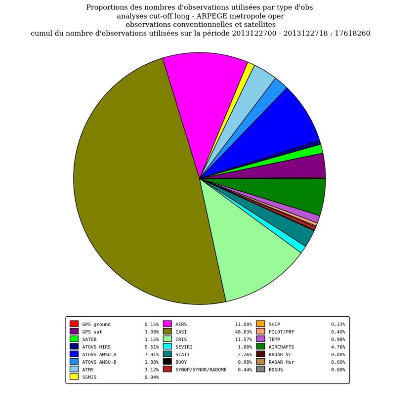
Main features of CY38T1 (OBS) – oper
Last operational suite on the NEC SX9 (2 July 2013) – migrated to
the new Météo-France HPC BULL B710 DLC (14 January 2014)
Instruments from new satellites : NASA/Suomi-NPP,
ISRO/Oceansat-2, EUMETSAT/MetOp-B
Increased usage of existing instruments :
– AIRS (over land + additional upper tropospheric channels)
– IASI (WV channels)
– GNSS-RO (reduced vertical thinning)
– Clear sky radiances (1 WV channel) from GOES-E and W
– Channels 4 and 5 from MHS/NOAA19
=> Increase of data by a factor of 2 (in assimilation cycles)
5
New satellites

                                      Suomi-NPP (launched 28/10/2011)
                                      -Advanced Technology Microwave
                                      Sounder (ATMS)
                                      -Cross track Infrared Sounder (CrIS)

    OCEANSAT-2 (launched 09/2009)
    -OSCAT(Ku-band scatterometer)
6   Discontinued – 21/02/2014
Evolution of the number of data in ARPEGE

        Actual numbers                        ---   Satellite data available
                                              __    Satellite data used

                                              ---   Conventional data available
                                              __    Conventional data used

    __ Satellite / All available
    __ Satellite used / Satellite available

    ---- Conv used / Conv available
    __ Satellite / All used                                              Percentages

7
Current usage of observations in ARPEGE

                AIRS                                     AMSU-A
                                      CY38T1
            AIRS

                    AMSU-A
        IASI                                               Aircrafts
                                                                RO
                                                                -
                                                            GPS
         IASI         Aircra
                   CriS      fts

                                                     Temp

                             CY37T1                             CY37T1
    Number of observations                     Fractional DFS

8
FSO : CY37T1 vs. CY38T1

 Number of          Forecat Error
observations
                    Contribution
  per type

               Forecast error
               Contribution in
               percentage           CY37T1

                                    CY38T1
FSO : CY37T1 vs. CY38T1
CY37T1                                            CY38T1

  ++      +       -       --

                        Comp-U+V                      Comp-U+V

  Surface ocean winds                  Improvement
                                        Improvement

  CY37T1 : ASCAT-A
  CY38T1 : ASCAT-A + ASCAT-B + OSCAT   Degradation
                                       Degradation
Monitoring vs FSO (1)
OSCAT
FSO(comp-U+V) RMS WV (obs-bg)Monitoring vs FSO (2)
ASCAT-B
FSO(comp-U+V) RMS WV (obs-bg)ARPEGE forecast scores
CY38T1
CY38T1
Z 500 hPa at day-3 over Northern Hemisphere
13Use of observations in AROME (CY38T1)
Same additional observations as in ARPEGE
Assimilation of additional SEVIRI channels over land (Ts
retrieval + use of LandSAF emissivity atlas)
AMSU-A : channels 9 and 10 + thinning at 80 km
Doppler wind from X band radar (Mt Maurel from
RHYTMME)
14Use of observations in AROME (CY38T1)
DFS
Rain
DFS
No rain
IASI
RADAR radial wind
RADAR humidity (reflectivity)
SYNOP
AIRCRAFTS
15Revision to our forecasting systems
Planned for Feb. 2015 with CY40 (e-suite in Jul. 2014) :
ARPEGE Model : T1198c2.2 (∆x = 7.5 km) L105
AROME Model : ∆x = 1.3 km L90
ARPEGE 4D-Var : Two inner loops (40 + 40 iterations)
ARPEGE Ensemble 4D-Var : 25 members
Planned usage of observations for ARPEGE :
– Revised tunning of observation errors
– Assimilation of SAPHIR (~ AMSU-B/MHS) from MEGHA-TROPIQUES
– Assimilation of sounding channels from SSMI/S F17 and F18
– Use of RTTOV-10 with internal interpolation
– Assimilation of GEORAD from METEOSAT-7 and MTSAT-2
– Assimilation of GPS ZTD from NOAA stations
16Ongoing developments on AROME
Revisions of the satellite variational bias correction (new set of
predictors) and to the channel selection with a model top at 10 hPa
Improvement to the GPS bias correction (VarBC scheme) + revised
ZTD observation operator
Increased radar density : thinning on individual radars (more data in
overlapping regions) + tests with an horizontal thinning at 8 km
Diagnostics on observation error correlations (radiances + radars)
Preliminary activities towards the assimilation of OPERA radar
reflectivities
Preparation of future instruments : polarimetric radar data, ground
based radiometers, IR hyperspectral sounder MTG-IRS
17New GPS pre-processing
Phase 1 : monitoring (1 month) to compute statistics for every
couple (station/analysis centre)
– Bias, Std(obs-guess), Nb gross errors, Nb data available
⇒ Extended white list (quality and regularity of data) + sigma_o
Phase 2 : Pre-processing (Bator)
– 1h superobing for ARPEGE, selection of closest data to the center of
the time-slot (AROME, ALADIN)
Phase 3 : Screening
– Background check, dynamic selection of the best (station/analysis
centre) at every location, no selected data = passive
Phase 4 : Assimilation and VarBC
– New observation operator to evaluate ZTD above model top
– Two predictors for VarBC : constant + TCWV
18Current status of ODC for data assimilation
About 130 european radars are received in real time : reflectivity +
Doppler wind (for some countries : Croatia, Denmark, Estonia,
Finland, France, Ireland, Netherlands, Poland, Slovakia, Sweden) in
common format ODIM BUFR or ODIM HDF5 – polar coordinate
(1°x1km)
Recent evolution of radar data from France (18/03/2014) for ODC :
– Identification of ground clutter with « no data » flag instead of
« undetect »
– No reflectivity threshold at 0 dBZ
– No filtering of isolated pixels and groups of isolated pixels
– Ground clutter filtering modified when SNR is small
– Radial wind velocity added to the raw reflectivity
19Use of OPERA data : current strategy
Adaptation of CONRAD tool developed by Hirlam Consortia
CONversion of RADar data in MF-BUFR format:
• format conversion
• Use of Zraw, Zfiltered to add metadata to create ODB base for AROME
Format converter
Raw Radar data
Local reader libs CONRAD CORE libs
CONRAD BUFR write routines
HDF5
BUFR
Fortran
libemos
MF-BUFR AROME
BATOR AROME /
HARMONIE
ODBUse of OPERA data : current strategy
Adaptation of CONRAD tool developed by Hirlam Consortia
CONversion of RADar data in MF-BUFR format:
• format conversion
• Use of Zraw, Zfiltered to add metadata to create ODB base for AROME
Format converter
Raw Radar data
Local reader libs CONRAD CORE libs
CONRAD BUFR write routines
HDF5
BUFR Odim structure
Written in C (from OPERA) Fortran
ODIM BUFR libemos
radar_data_t structure…
MF-BUFR AROME
ODIM BUFR: not a standard/native BUFR format: need
for a specific data decompression structure: BATOR AROME /
my_decompress …
HARMONIE
ODBUse of OPERA data : current strategy
Adaptation of CONRAD tool developed by Hirlam Consortia
CONversion of RADar data in MF-BUFR format:
• format conversion
• Use of Zraw, Zfiltered to add metadata to create ODB base for AROME
Format converter
Raw Radar data
Local reader libs CONRAD CORE libs
CONRAD BUFR write routines
HDF5
BUFR Odim structure
Written in C (from OPERA) Fortran
ODIM BUFR libemos
radar_data_t structure…
Ok for French and
German radar data
ODIM BUFR: not a standard/native BUFR format: need
for a specific data decompression structure:
my_decompress … Not yet for all other
ODIM HDF5: development is underway, still not countries
satisfactoryThe MF-BUFR radar product for AROME
0 - Dark blue: low 8 - Red: Rain
Signal-Noise-ratio
Trappes OPER
Z Vr QFlag
0 : Noise 8 : rain
1 : static clutter 9 : large dropplets 1- 2 - 3: clutter
2 : dynamic clutter (sigma) 10 : rain/hail
3 : close to clutter < 1 km 11 : fine hail 4 – 5 : insects,
4 : clear sky (insects, birds…) 12 : hail birds, sea clutter,
5 : military decoy, sea clutter 13 : dry snow
military decoy
6 : sea clutter by vertical gradient and texture 14 : wet snow
7 : drizzle 15: crystalsComparison between MF-BUFR and ODC products
Trappes MF-BUFR
2- Less detected clutter
Trappes Zfiltered 8- wrong rain
ODCIssues with filtering of ground clutter in ODC (1) Toulouse OPER Toulouse Zfiltered 8 – wrong small rain ODC –10 dBZ
Issues with filtering of ground clutter in ODC (2)
Toulouse –10 dBZ

                            0 – wrong rain
Toulouse+10 dBZ             becomes low SNR
Wrong rain becomes low SNR: to adapt treatment in AROME
Threshold : -10 dBZ
Threshold : +10 dBZ !
1. Ok: loss of good
detected rain!
2. But, to be careful
to not wrongly
dry!Polarimetric forward operator
Inputs: model prognostic variables (T°, qv, qr,
qs, qg, qc, qi …) on a 3D grid
Caumont et al., 2006 Parameters fixed by the
microphysical scheme ICE3 :
PSD, snow/graupel/ice
density
« Free parameters » :
Hydrometeor shape,
orientation (oscillation),
dielectric constant
=> Defined after a
sensitivity study
Outputs : radar variables (VR, ZH, ZDR, ρHV, ΦDP,
KDP, …) interpolated onto radar PPIs
Simulates beam bending, beam propagation (attenuation, differential
attenuation, differential phase) and backscattering
Simulates Signal-to-Noise Ratio (SNR)Radar/model comparisons
Montclar radar (C band, 24/09/2012)
Rain Snow
Distribution
of Zdr =
f(Zhh)
Distribution
of Kdp =
f(Zhh)Radar/model comparisons 30
Montclar radar (C band, 24/09/2012)
Distribution of Zhh, Zdr and Kdp as a function of temperature in convective areas
Radar
Model
Zhh Zdr KdpCliquez pour modifier le style du titre
Thank you for your attention !
Cliquez pour modifier le style des
sous-titres du masque
31You can also read