Nova Scotia Proposal of the Federal Electoral Boundaries Commission for the Province of
←
→
Page content transcription
If your browser does not render page correctly, please read the page content below
Proposal of the Federal
Electoral Boundaries
Commission for the
Province of

Nova Scotia
Published pursuant to the Electoral
Boundaries Readjustment Act
ISBN 978-0-660-42873-4

Cat. No.: SE3-123/1-2022E-PDF

© Federal Electoral Boundaries Commission for the Province of Nova Scotia, 2022

All rights reserved

Table of Contents

Introduction ........................................................................................................ 4

Representation to the Commission .................................................................. 8
     Do You Want to Make a Representation to the Commission? .................................... 8

Notice of Sittings ................................................................................................ 9

Rules ................................................................................................................. 10

APPENDIX – Maps, Proposed Boundaries and Names of
Electoral Districts ............................................................................................. 12
     Nova Scotia ............................................................................................................... 20
     Halifax ....................................................................................................................... 21

                                                                                                          Table of Contents               3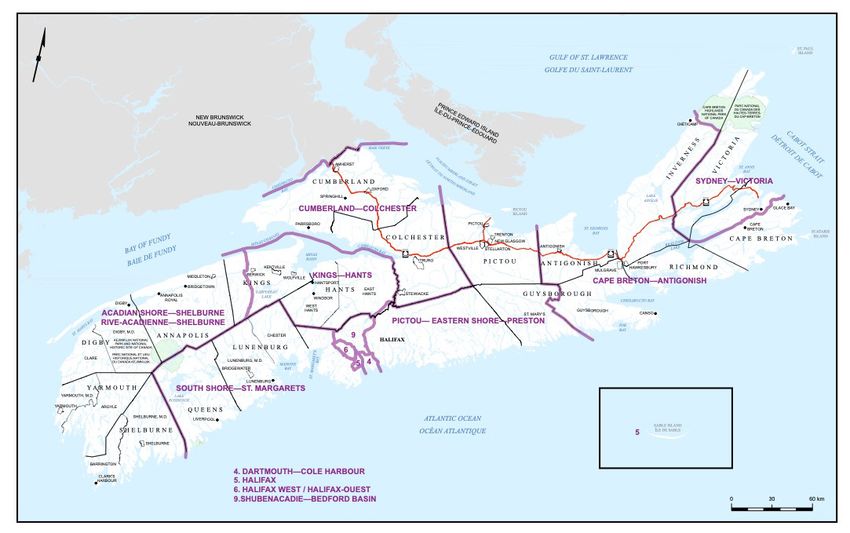
Introduction

By Order in Council dated November 1, 2021, the Federal Electoral Boundaries Commission for
the Province of Nova Scotia (the Commission) was established pursuant to the Electoral
Boundaries Readjustment Act, R.S.C. 1985, c. E-3 (the Act).

The Commission is comprised of three members: Dr. Louise Carbert, Dr. David Johnson and
Justice Cindy A. Bourgeois. Both Dr. Carbert and Dr. Johnson are political science professors,
at Dalhousie University and Cape Breton University respectively, and were appointed by the
Speaker of the House of Commons. Justice Bourgeois sits on the Nova Scotia Court of Appeal
and was appointed by the Chief Justice of Nova Scotia. The Commission is assisted in its work
by its Secretary, Ms. Carol Moulaison.

The role of the Commission is, in response to the 2021 decennial census, to examine and
readjust the boundaries of the federal electoral districts (also known as constituencies or
ridings) within the province. There are currently 11 electoral districts and this number will remain
unchanged.

The 2021 decennial census documented the population of the province as 969,383. Dividing the
total population by 11 gives an average or “electoral quota” of 88,126 people in each district.
Section 15 of the Act says that the number of people in each electoral district must correspond
as closely as is reasonably possible to that electoral quota. In attempting to achieve this goal,
the Commission must consider two factors:

   1. The community of interest, community of identity or historical pattern of an electoral
      district in the province
   2. A manageable geographic size for districts in sparsely populated, rural or northern
      regions of the province (subsection 15(1)(b) of the Act)

These factors can also provide justification to depart from the electoral quota in an electoral
district. However, the Act provides that, except in extraordinary circumstances, the population in
the electoral district must remain within 25% more or 25% less of the electoral quota. For the
Commission’s work, this means that an electoral district can have no fewer than 66,095 people
and no more than 110,158 unless there are extraordinary reasons to depart from that variance.
The Commission has not identified any extraordinary circumstances; therefore, all 11 electoral
districts must fall within the population range noted above.

                                                                                Introduction       4
In conjunction with the Act, the Commission’s decisions must also be guided by the Canadian
Charter of Rights and Freedoms, particularly section 3 which guarantees Canadian citizens the
right to vote in federal and provincial elections. This right has been interpreted by the Supreme
Court of Canada in a manner that sets constitutional criteria for the drawing of electoral
boundaries. In what is known as “the Carter decision,” the Supreme Court said that the right to
vote means the right to “effective representation,” not just an equality of voting power. The Court
ruled “effective representation” requires “relative parity of voting power.” Absolute equality of
population size among electoral districts is not required. However, deviations from equality
resulting in “relative parity of voting power” for the purpose of accommodating geography,
communities of interest or minority representation must be “justified on the ground that they
contribute to better government of the populace as a whole.” In other words, the variation from
the electoral quota established under the Act must be justified.

The Commission received the 2021 decennial population figures on February 9, 2022, and
immediately began its review, guided by the above principles. Table 1 below summarizes the
population in each electoral district after the 2012 redistribution was completed, as well as the
changes reflecting the 2021 census data. It also shows, as the boundaries currently exist, the
electoral quota variation by way of a positive or negative percentage. Several observations were
readily apparent to the Commission:

   •   The Province has recorded a population increase of 47,656 since the 2011 decennial
       census.
   •   There has been a significant increase in population in urban Halifax and its outlying
       areas. Notably, the riding of Halifax has increased in population by 14,367 in the last
       decade, and Halifax West accounts for over 50% of the province’s growth, with an
       increase of 24,669.
   •   Although other rural constituencies have shown smaller decreases in population, Cape
       Breton—Canso (a decrease of 3,867), Central Nova (a decrease of 1,409) and
       Sydney—Victoria (a decrease of 967) have shown the greatest losses.
   •   If the electoral boundaries remained unchanged, one riding, Halifax West, exceeds the
       permittable 25% variance. In addition, several other electoral districts, based on the new
       population data, have variances approaching this limit.

                                                                               Introduction      5
Table 1 – Federal Electoral Districts – Census Population 2012 and 2022

                                After Redistribution 2012         Prior to Redistribution 2022
                                (Electoral Quotient 83,793)       (Electoral Quotient 88,126)
 Electoral District Name
                                         2012            2012             2022               2022
                                    Population       Variation       Population          Variation
 Cape Breton—Canso                       75,247        -10.20%            71,380             -19.00%

 Central Nova                            74,597        -10.98%            73,188             -16.95%

 Cumberland—Colchester                   82,321         -1.76%            82,014              -6.94%

 Dartmouth—Cole Harbour                  91,212        +8.85%             96,165             +9.12%
 Halifax                                 92,643       +10.56%            107,010         +21.43%
 Halifax West                            87,275        +4.16%            111,944         +27.03%
 Kings—Hants                             83,306         -0.58%            87,744              -0.43%
 Sackville—Preston—
                                         85,583        +2.14%             89,524             +1.59%
 Chezzetcook
 South Shore—St.
                                         92,561       +10.46%             94,482             +7.21%
 Margarets
 Sydney—Victoria                         73,328        -12.49%            72,361             -17.89%

 West Nova                               83,654         -0.17%            83,571              -5.17%

 Total                                  921,727                          969,383

Based on the above, the Commission is of the view that the existing electoral boundaries
require alteration. It is not as simple however, as making a single adjustment to Halifax West to
bring it within the 25% permissible variance. Adjusting the boundary or boundaries of one riding
necessarily results in the adjustment of adjoining ridings, and this often causes a cascading
effect to others. The marked growth in the urban ridings requires that the Commission consider
how population can be added to more rural ridings. This results in a number of significant
boundary shifts being proposed, while remaining cognizant of communities of interest, historical
considerations and geographical constraints.

For the reasons stated above, the Commission proposes a re-alignment of the 11 federal
electoral districts for the province, including several changes of name, in accordance with
Table 2 below and the legal descriptions and maps of the proposed electoral districts as set out
in Appendix 1.

                                                                              Introduction        6
Table 2 – Population Information As It Would Be After the Proposed
Boundary Readjustments (Electoral Quota 88,126)
Electoral District Name After Redistribution in 2022 (Electoral Quota 88,126)
2021 Population Variation
Acadian Shore—Shelburne 89,956 +2.08%
Cape Breton—Antigonish 84,999 -3.55%
Cumberland—Colchester 82,014 -6.94%
Dartmouth—Cole Harbour 93,622 +6.24%
Halifax 97,243 +10.35%
Halifax West 90,917 +3.17%
Kings—Hants 87,409 -0.81%
Pictou—Eastern Shore—
88,398 +0.31%
Preston
Shubenacadie—Bedford
91,176 +3.46%
Basin
South Shore—St. Margarets 91,288 +3.59%
Sydney—Victoria 72,361 -17.89%
Total 969,383
In this document, you will also find the proposed places, dates and times for public hearings, at
which any interested party or parties may make representations in accordance with the rules set
out in this proposal. The Commission will also be offering a public hearing in a virtual format to
improve the ease of participation.
The Commission looks forward to hearing from all interested parties, either in person, virtually or
in writing. We ask that all interested parties pay particular attention to the rules set out herein
and check the Commission website (redistribution2022.ca) regularly for any changes of
schedule.
Introduction 7Representation to the Commission
Do You Want to Make a Representation to the Commission?
If you wish to make a representation to the Committee about this proposal, please carefully
review the rules outlined below. There are several ways to make a representation:
• By using the tools found on the Commission website (redistribution2022.ca).
• By sending written submissions to the Commission Secretary at the address set out
below no later than May 23, 2022.
• By providing an oral presentation to the Commission at one of the scheduled public
hearings. Please note that persons wishing to provide an oral representation must give
notice of their intention to do so no later than May 23, 2022. Notice should be directed to
the Commission Secretary and should include the information specified in the rules.
Written submissions can be mailed to the Commission Secretary at the following address:
Ms. Carol Moulaison
Commission Secretary
Federal Electoral Boundaries Commission for Nova Scotia
PO Box 70071, RPO Cobequid
Lower Sackville, NS B4C 2N0
Alternatively, written submissions can be submitted via email to:
NS-NE@redecoupage-federal-redistribution.ca
Notice of an intention to provide a representation to the Commission at a public hearing can be
mailed or emailed to the addresses above.
Representation to the Commission 8Notice of Sittings
The Commission is required by the Act to hold sittings to hear representations by interested
parties about the recommended changes to the boundaries of the electoral districts. For this
purpose, the Commission is scheduled to sit at the following places and times:
Location Place of hearing Date of hearing Time of
hearing
Sydney Cambridge Suites Monday,
6:30 p.m.
380 Esplanade Street May 30, 2022
Antigonish Town Hall Tuesday,
6:30 p.m.
274 Main Street May 31, 2022
Truro Best Western Truro Glengarry Wednesday,
6:30 p.m.
150 Willow Street June 1, 2022
Kentville Town Hall Monday,
6:30 p.m.
354 Main Street June 6, 2022
Yarmouth Rodd Grand Hotel Tuesday,
6:30 p.m.
417 Main Street June 7, 2022
Bridgewater Best Western Plus Bridgewater Wednesday,
6:30 p.m.
527 Highway 10, Exit 12 June 8, 2022
Cole Harbour Cole Harbour Place Monday,
6:30 p.m.
51 Forest Hills Parkway June 13, 2022
Lower Sackville Acadia Hall Tuesday,
6:30 p.m.
650 Sackville Drive June 14, 2022
Virtual hearing The link will be provided to Monday,
6:30 p.m.
participants June 27, 2022
Notice of Sittings 9Rules
The Commission makes the following rules in accordance with section 18 of the Electoral
Boundaries Readjustment Act, R.S.C. 1985, c. E-3.
1. These rules may be referenced as the “Rules of the Federal Electoral Boundaries
Commission for the Province of Nova Scotia, 2022”.
2. In these Rules:
(a) “Act” means the Electoral Boundaries Readjustment Act, R.S.C. 1985, c. E-3;
(b) “advertisement” means a notice or notices published as directed in subsection 19(2)
of the Act setting forth the places and the times when the sittings shall be held for the
hearing of representations;
(c) “chairperson” includes the deputy chairperson;
(d) “Commission” means the Federal Electoral Boundaries Commission for the Province
of Nova Scotia established by Order in Council of November 1, 2021;
(e) “notice” means a written expression of intention to make a representation in
compliance with subsection 19(5) of the Act (“within 23 days after the date of the
publication of the advertisement”);
(f) “representation” means any expression of opinion presented at a duly convened
sitting of the Commission relating to the division of the Province of Nova Scotia into
electoral districts and the names and boundaries of each electoral district, as
proposed by the Commission;
(g) “Secretary” means the Secretary to the Commission;
(h) “sitting” means a public hearing convened by the Commission in accordance with
and for the purposes set out in section 19 of the Act.
3. Unless the Commission decides otherwise, only one person or a designated
spokesperson shall be heard in the presentation of a representation at a sitting.
4. A person giving notice shall state therein at which of the places designated in the
advertisement they wish to make a representation, their contact information, the official
language in which they will present and any accommodation needs they may have.
5. If a person giving notice fails to comply with the provisions of rule 4, the Secretary shall
attempt to ascertain from such person the place at which such person wishes to appear
to make a representation and the official language in which it is to be made. For this
reason, it is essential to provide contact information in the notice.
Rules 106. If it appears to the Commission that no one requests to make a representation at a place
designated by the advertisement as a place of sitting, the Commission may cancel the
sitting at such place.
7. In the event that multiple notices are received requesting to provide representations at a
given sitting, the Commission may, in its discretion, set time limits on the length of each
presentation. The Secretary will advise persons who have provided notice, in advance of
the sitting, of any time limits set by the Commission.
8. Two members of the Commission shall constitute a quorum for the holding of a sitting.
9. If a quorum cannot be present at a sitting, the Commission may provide for the hearing
of representations by one member of the Commission pursuant to section 18 of the Act,
or may postpone the sitting to a later date.
10. The Secretary shall inform any person who has given notice, but has not been heard, of
a postponement. Public advertisement of a postponement may also be given by the
chairperson or the Commission by such means as the chairperson or it considers
adequate.
11. When the hearing of a representation cannot be completed within the time allotted, the
Commission may adjourn the sitting to a later date at the same or another place.
12. The Commission will consider any written submissions received at the Commission’s
office prior to May 23, 2022.
13. The Commission shall have the power to waive any procedural requirement where the
Commission deems there to be a defect in form and not in substance.
14. The Commission will require all persons in attendance at sittings to adhere to all public
health directives which may be in place at that time.
Given the pandemic situation and the increased expectation from the public with regard to
online services, the Nova Scotia Commission will hold a virtual public hearing. In addition to the
principles applied for in-person public hearings, the following procedures and requirements will
apply for virtual public hearings:
15. The link to the virtual public hearing is not public and is only shared with participants or
observers who have registered with the Commission and to members of the media.
16. A moderator will manage the agenda, speaking time and microphones of the
participants.
17. Participants will have the option to share their screen.
18. The use of a headset by presenters is recommended.
19. The video feed from the presenters is optional and they may simply participate by
phone.
Rules 11APPENDIX – Maps, Proposed
Boundaries and Names of Electoral
Districts
There shall be in the province of Nova Scotia eleven (11) electoral districts, named and
described as set out below, each of which shall return one member.
In the following descriptions:
(a) reference to “street,” “avenue,” “road,” “drive,” “connector,” “extension,” “highway,” “river,”
“stream,” “brook,” “channel,” “cove,” “arm,” “bay,” “lake,” “harbour,” “transmission line” or
“railway” signifies their centre line unless otherwise described;
(b) wherever a word or expression is used to denote a territorial division, such word or
expression shall indicate the territorial division as it existed or was bounded on the first day of
January 2021;
(c) reference to “counties” for inclusion in an electoral district signifies that all cities, towns,
villages and Indian reserves lying within the perimeter of the counties are included unless
otherwise described;
(d) all offshore islands are included in the landward district unless otherwise described;
(e) the translation of the terms “street,” “avenue” and “boulevard” follows Treasury Board
standards, while the translation of all other public thoroughfare designations is based on
commonly used terms but has no official recognition; and
(f) all coordinates are in reference to the North American Datum of 1983 (NAD 83).
The population figure of each electoral district is derived from the 2021 decennial census.
APPENDIX – Maps, Proposed Boundaries and Names of Electoral Districts 12Acadian Shore—Shelburne
(Population: 89,956)
(Map 1)
Consists of:
(a) the counties of Annapolis, Digby, Shelburne and Yarmouth; and
(b) that part of the County of Kings lying westerly of a line described as follows: commencing at
a point where Turner Brook flows into the Bay of Fundy at approximate latitude 45°8'38"N and
longitude 64°50'14"W; thence southeasterly along said brook to Long Point Road; thence
generally southerly along said road to Highway 221; thence southwesterly along said highway to
the continuation of Long Point Road; thence generally southerly along said road to Highway 1
(Evangeline Trail); thence westerly along said highway to Aylesford Road; thence generally
southerly, southeasterly and southerly along said road to the southerly limit of the County of
Kings.
Cape Breton—Antigonish
(Population: 84,999)
(Map 1)
Consists of:
(a) the counties of Antigonish and Richmond;
(b) the Municipality of the District of Guysborough;
(c) that part of the County of Inverness lying southerly of Cape Breton Highlands National Park
of Canada; and
(d) that part of the Cape Breton Regional Municipality lying southeasterly of a line described as
follows: commencing at a point in the centre of Bras d’Or Lake; thence northeasterly along said
lake and East Bay to its most northeasterly extremity; thence due north to Portage Brook;
thence generally northeasterly along said brook to Blacketts Lake; thence generally
northeasterly along said lake and the Sydney River to Highway 125; thence generally
northeasterly along said highway to Highway 4 (Grand Lake Road); thence northeasterly along
said highway to an unnamed brook (at approximately 130 metres from the intersection with
Highway 125); thence generally northeasterly along said brook and the westerly shoreline of
Grand Lake to the Sydney Coal Railway; thence northeasterly along said railway and its
northerly branch (running towards the Community of Dominion) to its second intersection with
Northwest Brook (north of Grand Lake); thence generally northerly and northeasterly along said
brook, Lingan Bay and Indian Bay to the Cabot Strait.
APPENDIX – Maps, Proposed Boundaries and Names of Electoral Districts 13Cumberland—Colchester
(Population: 82,014)
(Map 1)
Consists of the counties of Colchester and Cumberland.
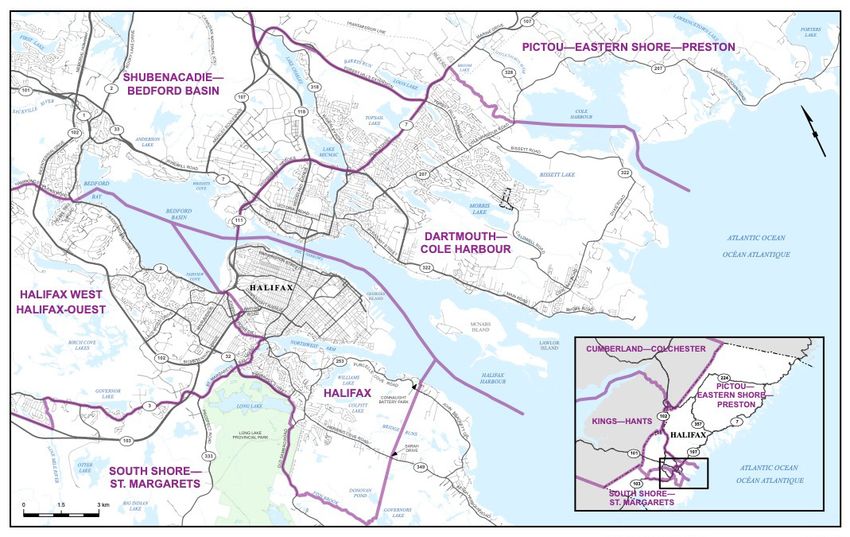
Dartmouth—Cole Harbour
(Population: 93,622)
(Map 2)
Consists of that part of the Halifax Regional Municipality described as follows: commencing at a
point in Halifax Harbour at the intersection with the Atlantic Ocean at latitude 44°33'43"N and
longitude 63°30'00”W; thence generally northwesterly along said harbour (passing to the west of
McNabs Island and to the east of Georges Island) to the A. Murray Mackay Bridge (Highway
111); thence northeasterly along said bridge to Highway 111 (Highway of Heroes); thence
northeasterly, easterly and southeasterly along said highway to Highway 7 (Main Street); thence
northeasterly along said street to a transmission line (933 Main Street) approximately 200
metres west of Riley Road; thence southerly along said transmission line to an unnamed brook
flowing southerly from Broom Lake; thence generally southerly along said brook to Cole
Harbour (approximate latitude 44°40'25"N and longitude 63°27'47"W); thence generally
southeasterly along said harbour to a point in the Atlantic Ocean at latitude 44°35'32"N and
longitude 63°21'48"W; thence westerly in a straight line to the point of commencement.
Halifax
(Population: 97,243)
(Map 2)
Consists of:
(a) that part of the Halifax Regional Municipality described as follows: commencing at a point in
Bedford Basin at latitude 44°41'33"N and longitude 63°38'16"W; thence generally southeasterly
along said basin, The Narrows and Halifax Harbour (passing to the east of Georges Island and
to the west of McNabs Island) to a point in the Halifax Harbour at latitude 44°36'35"N and
longitude 63°32'53"W; thence southwesterly in a straight line to the southeasternmost point of
Connaught Battery Park (approximate latitude 44°36'16"N and longitude 63°33'34"W); thence
generally southwesterly along said park limit to Purcells Cove Road; thence southwesterly in a
straight line to the northeasternmost point of Sarah Drive; thence southwesterly along said road
to Herring Cove Road; thence southwesterly in a straight line to the intersection of Fish Brook
and Governors Lake (approximate latitude 44°34'4"N and longitude 63°36'28"W); thence
generally northwesterly along said brook to Old Sambro Road; thence generally northerly and
APPENDIX – Maps, Proposed Boundaries and Names of Electoral Districts 14northeasterly along said road to the eastern limit of Long Lake Provincial Park (approximate
latitude 44°36'34"N and longitude 63°37'34"W); thence northerly and northeasterly along said
provincial park limit to McIntosh Run; thence southeasterly along said run to Old Sambro Road;
thence generally northerly along said road to Dunbrack Street; thence generally northwesterly
and northerly to St. Margarets Bay Road; thence generally easterly along said road to Joseph
Howe Drive; thence generally northerly along said drive to Highway 102 (Bicentennial Highway);
thence northeasterly along said highway and its northbound split to Bayers Road; thence
easterly along said road to the Canadian National Railway; thence generally northerly along
said railway to Bedford Highway (Highway 2); thence westerly along said highway to the
Bedford Highway off-ramp situated north of Main Avenue; thence northwesterly in a straight line
to the southernmost shoreline of Fairview Cove; thence northerly in a straight line to the point of
commencement in Bedford Basin; and
(b) Sable Island.
Halifax West
(Population: 90,917)
(Map 1)
Consists of that part of the Halifax Regional Municipality described as follows: commencing at
the intersection of Highway 103 (Fishermen’s Memorial Highway) and Hammonds Plains Road;
thence northeasterly along said road to the northwesterly boundary of Wallace Hills Indian
Reserve No. 14A; thence northeasterly and southeasterly along the westerly and northerly
boundaries of said Indian reserve to Hammonds Plains Road; thence generally easterly and
southeasterly along said road to Bedford Highway; thence southerly along said highway to
Moirs Mill Road; thence easterly in a straight line to a point in Bedford Bay at latitude
44°42'52"N and longitude 63°39'51"W; thence generally southeasterly along said bay to a point
in Bedford Basin at latitude 44°41'33"N and longitude 63°38'16"W; thence southerly to the
southernmost extremity of Fairview Cove (approximate latitude 44°39'50"N and longitude
63°37'51"W; thence southeasterly in a straight line to the intersection of Bedford Highway with
the Bedford Highway off-ramp situated northwest of Main Avenue; thence easterly along said
highway to the Canadian National Railway; thence generally southerly along said railway to
Bayers Road; thence westerly along said road to the northbound split of Highway 102; thence
southwesterly along said highway to Joseph Howe Drive; thence generally southerly and
southeasterly along said drive to St. Margarets Bay Road (Highway 3) at the Armdale Rotary;
thence generally westerly and northwesterly along said road to the intersection of Nine Mile
River; thence southerly along said river to Highway 103 (Fishermen’s Memorial Highway);
thence generally northwesterly along said highway to the point of commencement.
APPENDIX – Maps, Proposed Boundaries and Names of Electoral Districts 15Kings—Hants
(Population: 87,409)
(Map 1)
Consists of:
(a) that part of the County of Kings lying easterly of a line described as follows: commencing at
a point where Turner Brook flows into the Bay of Fundy at approximate latitude 45°8'38"N and
longitude 64°50'14"W; thence southeasterly along said brook to Long Point Road; thence
generally southerly along said road to Highway 221; thence southwesterly along said highway to
the continuation of Long Point Road; thence generally southerly along said road to Highway 1
(Evangeline Trail); thence westerly along said highway to Aylesford Road; thence generally
southerly, southeasterly and southerly along said road to the southerly limit of the County of
Kings; and
(b) that part of the County of Hants excluding the area as follows: commencing at the
intersection of Highway 102 (Veterans Memorial Highway) and the southerly limit of said county;
thence generally northeasterly along said highway to Highway 14; thence easterly along said
highway to Highway 2; thence generally southerly along said highway to Milford Road; thence
easterly along said road to the limit of the County of Hants (Shubenacadie River); thence
generally southwesterly along said limit to the point of commencement.
Pictou—Eastern Shore—Preston
(Population: 88,398)
(Map 1)
Consists of:
(a) the County of Pictou;
(b) the Municipality of the District of St. Mary’s;
(c) that part of the Halifax Regional Municipality lying easterly of a line described as follows:
commencing at the intersection of the northerly limit of said regional municipality with
Highway 102 (Veterans Memorial Highway); thence generally southerly along said highway to
Highway 118; thence southerly along said highway to Highway 107 Bypass (Forest Hills
Extension); thence northeasterly and southeasterly along said highway to Highway 7 (Main
Street); thence northeasterly along said highway to a transmission line (933 Main Street)
approximately 200 metres west of Riley Road; thence southerly along said transmission line to
an unnamed brook flowing from Broom Lake; thence generally southerly along said brook to
Cole Harbour (approximate latitude 44°40'25"N and longitude 63°27'47"W); thence generally
southeasterly along said harbour to a point in the Atlantic Ocean at latitude 44°35'32"N and
longitude 63°21'48"W; and
APPENDIX – Maps, Proposed Boundaries and Names of Electoral Districts 16(d) that part of the Municipality of the District of East Hants lying southeasterly and
southwesterly of a line described as follows: commencing at the intersection of the southerly
limit of said municipal district with Highway 102 (Veterans Memorial Highway); thence generally
northeasterly along said highway to Highway 14; thence easterly along said highway to
Highway 2; thence generally southerly along said highway to Milford Road; thence generally
easterly along said road to the limit of the Halifax Regional Municipality (Shubenacadie River).
Shubenacadie—Bedford Basin
(Population: 91,176)
(Map 1)
Consists of that part of the Halifax Regional Municipality described as follows: commencing at
the intersection of the northern limit of said municipality with Highway 102 (Veterans Memorial
Highway); thence generally southwesterly along said highway to Highway 118; thence southerly
along said highway to Highway 107 Bypass (Forest Hills Extension); thence generally easterly
and southeasterly along said highway to Highway 7 (Main Street); thence generally
southwesterly along said highway to Highway 111 (Highway of Heroes); thence northwesterly,
westerly and southwesterly along said highway and the A. Murray Mackay Bridge to the
midpoint of said bridge; thence generally northwesterly along The Narrows and Bedford Basin to
a point in Bedford Basin at latitude 44°36'35"N and longitude 63°32'53"W; thence generally
northwesterly along Bedford Basin and Bedford Bay to a point in Bedford Bay at latitude
44°42'52"N and longitude 63°39'51"W; thence westerly in a straight line to the intersection of
Moirs Mill Road with Highway 2 (Bedford Highway); thence generally northerly along said
highway to Hammonds Plain Road; thence generally westerly along said road to the northeast
limit of Wallace Hills Indian Reserve No. 14A; thence northwesterly and southwesterly along
said reserve limit to Hammonds Plain Road; thence southwesterly along said road to Stillwater
Lake; thence northerly along said lake to its northernmost extremity at the mouth of East River;
thence northwesterly in a straight line to the mouth of Pockwock River at Wrights Lake; thence
northerly in a straight line to the westernmost extremity of Ponhook Cove in Pockwock Lake;
thence generally northerly along the westerly shoreline of said lake to the northerly limit of the
Halifax Regional Municipality; thence generally northeasterly along said municipal limit to the
point of commencement.
APPENDIX – Maps, Proposed Boundaries and Names of Electoral Districts 17South Shore—St. Margarets
(Population: 91,288)
(Map 1)
Consists of:
(a) the County of Lunenburg;
(b) the Regional Municipality of Queens; and
(c) that part of the Halifax Regional Municipality lying westerly of a line described as follows:
commencing at the intersection of the northerly limit of said regional municipality with the
westerly shoreline of Pockwock Lake; thence generally southerly along said shoreline to the
westernmost extremity of Ponhook Cove in Pockwock Lake; thence southerly in a straight line to
the mouth of the Pockwock River at Wrights Lake; thence southeasterly in a straight line to the
northernmost extremity of Stillwater Lake at the mouth of East River; thence southerly along
said lake to Highway 213 (Hammonds Plains Road); thence southwesterly along said highway
to Highway 103 (Fishermen’s Memorial Highway); thence generally southeasterly along said
highway to Nine Mile River; thence northerly along said river to Highway 3 (St. Margarets Bay
Road); thence generally southeasterly and easterly along said highway to Dunbrack Street;
thence generally southerly and southeasterly along said street to Old Sambro Road; thence
southerly along said road to McIntosh Run; thence northeasterly along said run to the southerly
boundary of Long Lake Provincial Park at latitude 44°36'51"N and longitude 63°37'22"W; thence
southwesterly and southerly along said provincial park boundary to Old Sambro Road; thence
generally southwesterly and southerly along said road to the intersection with Fish Brook
(approximate latitude 44°35'13"N and longitude 63°38'18"W); thence generally southeasterly
along said brook to Governors Lake (approximate latitude 44°34'4"N and longitude
63°36'28"W); thence northeasterly in a straight line to the intersection of Herring Cove Road and
Sarah Drive; thence northeasterly along said drive and its production in a straight line to the
southwesternmost point of Connaught Battery Park (approximate latitude 44°36'8"N and
longitude 63°33'44"W); thence generally northeasterly along said park boundary to the
southeasternmost point of said park (approximate latitude 44°36'16"N and longitude
63°33'34"W); thence northeasterly in a straight line to a point in Halifax Harbour at latitude
44°36'35"N and longitude 63°32'53"W; thence generally southeasterly along said harbour
(passing west of McNabs Island) to a point in the Atlantic Ocean on the southerly limit of the
Halifax Regional Municipality at latitude 44°33'43"N and longitude 63°30'00"W.
APPENDIX – Maps, Proposed Boundaries and Names of Electoral Districts 18Sydney—Victoria
(Population: 72,361)
(Map 1)
Consists of:
(a) the County of Victoria;
(b) that part of the County of Inverness lying northerly of the southerly boundary of Cape Breton
Highlands National Park of Canada; and
(c) that part of the Cape Breton Regional Municipality lying northwesterly of a line described as
follows: commencing at a point in the centre of Bras d’Or Lake; thence northeasterly along said
lake and East Bay to its most northeasterly extremity; thence due north to Portage Brook;
thence generally northeasterly along said brook to Blacketts Lake; thence generally
northeasterly along said lake and the Sydney River to Highway 125; thence generally
northeasterly along said highway to Highway 4 (Grand Lake Road); thence northeasterly along
said highway to an unnamed brook (at approximetely 130 metres from the intersection with
Highway 125); thence generally northeasterly along said brook and the westerly shoreline of
Grand Lake to the Sydney Coal Railway; thence northeasterly along said railway and its
northerly branch (running towards the Community of Dominion) to its second intersection with
Northwest Brook (north of Grand Lake); thence generally northerly and northeasterly along said
brook, Lingan Bay and Indian Bay to the Cabot Strait.
APPENDIX – Maps, Proposed Boundaries and Names of Electoral Districts 19Map Nova Scotia
1
Nova Scotia Map 20Map Halifax
2
Halifax Map 21You can also read