Multi-sensing geophysical surveys at the Archaeological Park of Paestum: the discovery of a small Doric temple.
←
→
Page content transcription
If your browser does not render page correctly, please read the page content below
Multi-sensing geophysical surveys at the
Archaeological Park of Paestum: the discovery of
             a small Doric temple.
 I. Catapano1, L. Capozzoli2, G. Ludeno1, G.Gennarelli1, G. De Martino2, E. Rizzo3, F. U. Scelza4, G.
                                     Zuchtriegel4, F. Soldovieri1

                        1. Institute for the Electromagnetic Sensing of the Environment, National Research Council, Italy
              2. National Research Council of Italy, Institute of Methodologies for Environmental Analysis, I-85050, Tito Scalo, Italy
                    3. University of Ferrara, Department of Physics and Earth Sciences, via Saragat 1, 44122, Ferrara, Italy
                                      4. Archaeological Park of Paestum, I-84047, Capaccio Paestum (SA)
The archaeological and geological contexts Paestum, originally called Poseidonia, represents one of the most important and major ancient Greek cities. The site is encircled by monumental city walls and three monumental and well-preserved Greek temples. The outer parts, placed between the ceremonial area and the city walls, have been poorly investigated and preserve a great potential for the archaeological research. The site is located in Paestume plain and it genesis was favored by the depositation of travertime thanks to the near carbonate aquifer of the Monte Soprano. Ilaria Catapano 27/04/2021
Discovery of the architectural elements On June 2019, during restoration and redevelopment work performed at the Western City Walls, architectural elements were detected in an area usually dedicated to agricultural activities The visual survey allowed the archaeologists to identify some exceptional findings highlighting the possible presence of a buried Doric temple of small size, which could represent an “unicum” in the archaeological history of the Magna Graecia Multi-sensor geophysical prospections were planned to survey the area quickly and, possibly, to locate the buried temple and further remains. Ilaria Catapano 27/04/2021
G-858 MagMapper Magnetometer
(Geometrics), connected to an external
Smart 1 Novatel GPS antenna. The
instrument was equipped with two
Multi-sensor archaeogeophysical approach separated magnetic sensors located at
different heights from the surface, which
The multi-sensors approach is based on the complementary use of permitted to perform a gradiometric
survey.
Magnetometry (MAG ) and Ground Penetrating Radar (GPR)
MAG detects archaeological remains by analysing the
variations of the earth magnetic field. It allows us
investigating large subsurface in relative short time and
identify large archaeological anomalies.
GPR allows a high-resolution imaging of shallow buried
remains in terms of geometry and depth. GPR is suited for
providing high resolution 2D and 3D images of the TH DUAL-F HI-Mod (IDS-Ingegneria
underground by allowing detection, localization, and dei Sistemi S.p.A), equipped with a multi-
geometry estimation of hidden/buried targets. frequency antenna able to operate to the
frequencies of 200 and 600 MHz
Ilaria Catapano 27/04/2021Data acquisition and data processing MAG data processing
MAG was used to investigate the two hectares
of subsoil by collecting data on evenly spaced
parallel lines with spacing of about 1 m.
The instrument was equipped with two
separated magnetic sensors located at different
heights from the surface, which permitted to
perform a gradiometric survey.
GPR data processing
GPR recorded 2D evenly spaced profiles
(0.50m spacing) along two perpendicular
directions distributed according to a regular grid
covering an area of 600m2.
The GPR data were collected by a dual-
frequency system working at 200 and 600 MHz.
Ilaria Catapano 27/04/2021Anomalies
associate to the
temple
MAG results
Two main kinds of anomalies were detected. Anomalies associate to
the streets
The first ones are located on the North-West of the
map, where two concentric rectangles shapes are well
highlighted in an area of extent of about 600 m2.
These anomalies could be associated to the presence of
the temple.
The second group of geomagnetic anomalies have a streets of the ancient city.
linear geometry with two main directions: east-west
and north-south. The merging of the ancient map of the
Paestum and the geomagnetic map on the satellite
image of the area, allowing to suppose that these liner Area of the
temple.
anomalies can be the streets of the ancient city.
Ilaria Catapano 27/04/2021GPR results
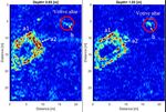
Depth slice images point out the presence of two
concentric rectangles; the outer rectangle (a2) has
extent 6m x 8m while the inner one has extent 4m x
6m (a1). The observed reflections highlight the top of
the structure, which is at a depth of about 0.6-1.0 m 3D microwave tomographic
reconstruction from 200 MHz
below the air-soil interface. GPR data - Constant depth slices
Two other interesting areas are detected:
• the first one (red circle in the depth slices at 0.85 m
and 1.05 m) could be associated to the presence of a
votive altar, similarly to the ones characterizing the
other temples of the site.
• the second reflective area (red rectangle) is at a depth
of 1.5-1.7 m and could be an ancient floor.
Reflections are identified up to about 2 m; the Temple
foundations could be located at this depth.
Ilaria Catapano 27/04/2021Excavation and virtual imaging Archeological excavation was performed at the Temple area identified by GPR A virtual image of the Temple was realized by the Sovrintendenza of the Archological Park of Paestum and Velia Ilaria Catapano 27/04/2021
Technological point of view:
the smart combined use of a different methodologies
allows a multiscale geophysical approach.
Archeological point of view:
the small temple represents the first evidence of the
entrance of a new "classic" Doric style at Paestum
The presented work is a good example about the
importance to adopt an archaeo-geophysical “step by step
approach” based on complementary use of geophysical
Contact:
methods and the subsequent step regarding the email: catapano.i@irea.cnr.it - Skype: ili.cat
archaeological implications of the geophysical surveys.
Reference:
Capozzoli, L et al. The Discovery of a Buried Temple in Paestum: The Advantages of
the Geophysical Multi-Sensor Application. Remote Sens. 2020, 12, 2711.
Ilaria Catapano 27/04/2021You can also read


