Metropolitan Parks and Open Space Committee Report
←
→
Page content transcription
If your browser does not render page correctly, please read the page content below

Business Item No. 2022-53

Metropolitan Parks and Open Space Committee Report
For the Community Development Committee meeting of March 7, 2022
For the Metropolitan Council meeting of March 23, 2022
Subject: Point Douglas Regional Trail Master Plan, Saint Paul
Proposed Action
That the Metropolitan Council:
    1. Approve the Point Douglas Regional Trail Master Plan.
    2. Require Saint Paul, prior to initiating any new development of the regional trail corridor, to send
       preliminary plans to the Metropolitan Council’s Environmental Services Interceptor Engineering
       Assistant Manager.

Summary of Committee Discussion/Questions
Tracey Kinney, Senior Planner, presented the staff report to the Metropolitan Parks and Open Space
Commission at its meeting on March 3, 2022. Brett Hussong, Lead Landscape Architect from Saint
Paul Parks was in attendance.
Chair Yarusso asked if this trail includes an area that was previously affected by erosion. Kinney
responded that erosion affects the interim alignment of Segment 1. A small part of the interim trail was
rebuilt after disrepair due to erosion. A study was conducted for future erosion mitigation improvements
for the overall interim trail.
Commission Peichel asked if the trail included connections to the Battle Creek Regional Park, Pigs Eye
Unit restoration work. Hussong responded the Point Douglas master plan effort didn’t engage Ramsey
County in relation to connecting to the Pigs Eye Unit. Emmett Mullin, Parks Manager responded that
the Pigs Eye restoration project is in a remediation phase so adding public opportunities to connect with
the lake is being held off until this work is done. Hussong added that the regional trail is separated from
the Pigs Eye Unit by a railroad. Access to the lake from the trail did not come into play.
Commissioner Dillenburg asked how inflation is being considered with master plan costs. Kinney
responded that the costs are tracked in the master plan in 2022 dollars. Lisa Barajas, Community
Development Director responded that the 2050 system plan update will need to consider inflation since
it is becoming an important factor to estimate the cost to complete the Regional Parks System. Chair
Yarusso added that this topic comes up from time to time. The Commission has discussed the
disconnect between balancing rising land and construction costs with the ability to maintain the existing
system.
Commissioner Peichel asked about the space available for hybrid facilities. Hussong responded that
the trail is located in the road shoulder or is using wide road lanes. The master plan was limited and
focused on the safety of the multi-use trail, so it did not consider any other uses.
Chair Yarusso asked about the master plan engagement with tribal communities. Hussong responded
that the Tribal Historic Preservation Office was contacted; but their engagement
was limited since it was a planning document. Saint Paul engaged with the

Page - 1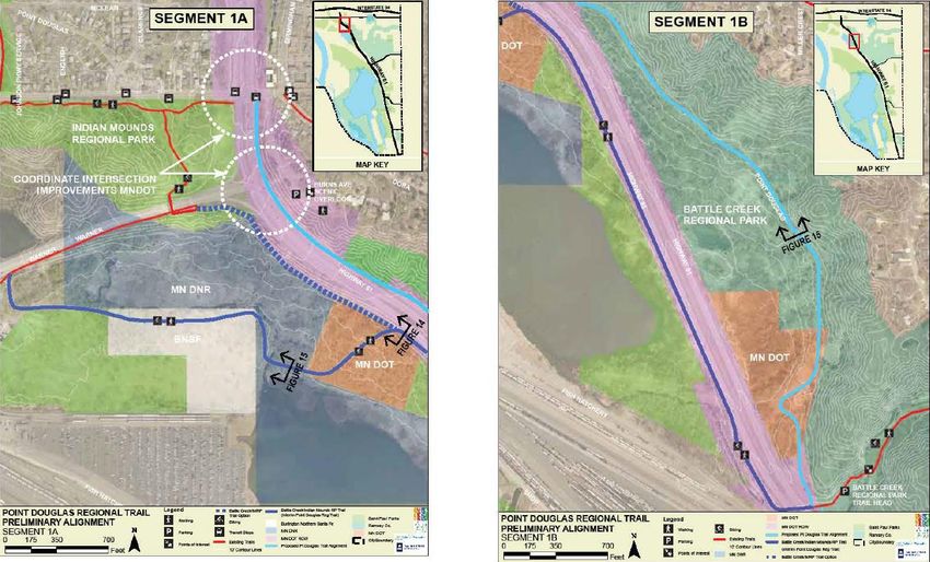
Minnesota State Historic Preservation Office which identified cultural sites of significance. A
geophysical study is needed in order to proceed with implementation of the master plan.
Chair Yarusso added that the regional trail includes a nice balance of trail and use of adjacent regional
parks. It is a good improvement to the existing trail which was noted in past public comments for the
need to improve it.
Council Member Vento added that the regional trail will be a great amenity and the neighbors will be
thankful for it.
The Commission voted unanimously to approve the proposed action.

Page - 2 | METROPOLITAN COUNCIL
Business Item No. 2022-53

Metropolitan Parks and Open Space Committee
Meeting date: March 3, 2022
For the Community Development Committee meeting of March 7, 2022
For the Metropolitan Council meeting of March 23, 2022
Subject: Point Douglas Regional Trail Master Plan, Saint Paul, Review File No. 50230-1
MPOSC District, Member: District G, Anthony Taylor
Council District, Member: District 13, Chai Lee
Policy/Legal Reference: Minn. Stat. § 473.313; 2040 Regional Parks Policy Plan: Chapter 5, Planning
Policy Strategy 1, Master Plans
Staff Prepared/Presented: Tracey Kinney, Senior Planner (651-602-1029)
Division/Department: Community Development / Regional Planning
Proposed Action
That the Metropolitan Council:
    1. Approve the Point Douglas Regional Trail Master Plan.
    2. Require Saint Paul, prior to initiating any new development of the regional trail corridor, to send
       preliminary plans to the Metropolitan Council’s Environmental Services Interceptor Engineering
       Assistant Manager.

Background
Saint Paul’s Point Douglas Regional Trail, formerly known as the Point Douglas (Bruce Vento-
Washington Co.) Search Corridor, is located centrally within of the Regional Parks System (Figure 1)
and the eastern part of the City of Saint Paul (Figure 2). This new 4-mile trail connects City of Saint
Paul to the City of Newport in Washington County along the east side of Highway 61 between Burns
Avenue and Bailey Road. The trail connects Battle Creek and Indian Mounds Regional Park, Samuel
Morgan Regional Trail, and Grand Round North Regional Trail to Washington County’s Afton Bluffs
Regional Trail and Mississippi River Regional Trail Search Corridors. The trail is also within the
Mississippi River Critical Corridor Area and is part of the Mississippi River Trail system (Figure 3).
This plan serves to establish a new master plan for, as well as change its name to Point Douglas
Regional Trail.
Rationale
The Point Douglas Regional Trail Master Plan is consistent with the requirements of the 2040 Regional
Parks Policy Plan (RPPP) including Chapter 5, Planning Policy Strategy 1.
Thrive Lens Analysis
The Point Douglas Regional Trail Master Plan advances the Thrive outcome of Livability by increasing
access to nature and outdoor recreation, which enhances the quality of life in the region.
Funding
The total estimated cost to complete the Point Douglas Regional Trail is
approximately $9,825,000 including $278,625 in acquisitions and $9,546,000 for
development. The annual cost to maintain the trail is $36,800.

Page - 1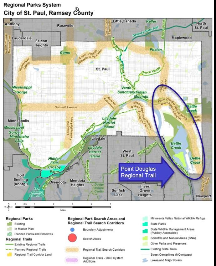
Known Support / Opposition
The Saint Paul City Council approved a Resolution of Support (22-49) for submission of the Point
Douglas Regional Trail Master Plan to the Metropolitan Council on February 2, 2022 (Attachment 1).

Page - 2 | METROPOLITAN COUNCIL

Figure 1. Point Douglas Regional Trail located within the Regional Parks System

Page - 3 | METROPOLITAN COUNCIL
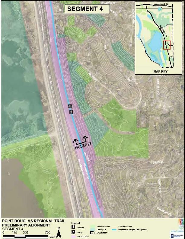
Figure 2. Search Corridor location in the City of Saint Paul

Page - 4 | METROPOLITAN COUNCIL
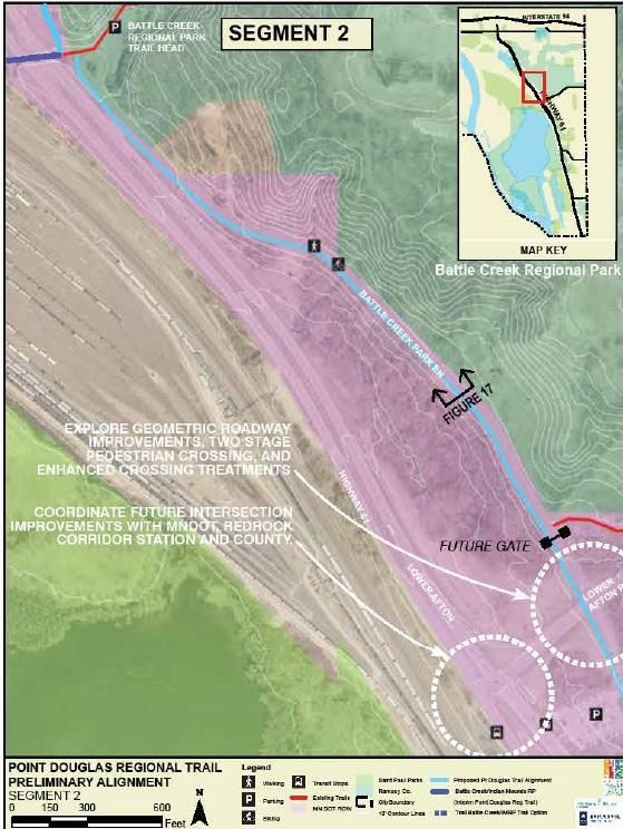
Figure 3. Point Douglas Regional Trail Master Plan

Page - 5 | METROPOLITAN COUNCIL
Analysis
Planning Strategy 1 of the 2040 Regional Parks Policy Plan requires that master plans for regional
linking trails address 13 items: boundaries, acquisition costs, demand forecast, development concept,
conflicts, public services, operations, partner engagement, public engagement and participation, equity
analysis, public awareness, accessibility, and the Mississippi River Corridor Critical Area. The following
report analyzes the master plan against those requirements.
Boundaries
Saint Paul’s Point Douglas Regional Trail connects the City of Saint Paul to the City of Newport in
Washington County along the east side of Highway 61 between Burns Avenue and Bailey Road. The
trail connects Battle Creek and Indian Mounds Regional Park, Samuel Morgan Regional Trail, and
Grand Round North Regional Trail to Washington County’s Afton Bluffs Regional Trail and Mississippi
River Regional Trail Search Corridors. The trail is also within the Mississippi River Critical Corridor Area
and is part of the Mississippi River Trail system (Figure 3).
Acquisition Costs
The majority of the acquisitions for the trail are 10-year limited use permits within Minnesota
Department of Transportation (MnDOT) road right-of-way. Securing these agreements are likely at the
cost of preparing and executing the documents.
The long-term solution for Segment 3B includes one private acquisition and four private easements
totaling $278,625 to reconstruct a 0.25-mile section of road with a separated trail facility since the width
is limited (Table 1).
Table 1. Private Acquisitions

 Parcel ID/Location             Area              Conveyance       Cost
 Private land                   0.27 Acre         Fee title        $200,800.00
 Private land                   772 Square Feet   Easement         $11,558.00
 Private land                   362 Square Feet   Easement         $8785.00
 Private land                   969 Square Feet   Easement         $14,95.00
 Private land                   3,086 Square      Easement         $45,672.00
                                Feet
 Total                          0.39 Acre                          $278,625.00*

*Estimated costs reflect 2020 tax assessed values for the portion of parcel needed
Demand Forecast
The Point Douglas Regional Trail will connect to the Samuel H. Morgan Regional Trail, which is the
most used regional trail in the City of Saint Paul. Saint Paul is projecting that the use of the trail will be
comparable to Bruce Vento Regional Trail, Samuel H. Morgan Regional Trail and Trout Brook Regional
Trail (Metropolitan Council’s 2019 Use Estimate).
Based upon Saint Paul’s 2020 Census data, the City’s population was 311,527 and expected to total
344,100 by 2040, which is a 10% increase. In addition, the 2016 Metropolitan Council Visitor Study
reported that 70% of trail users live within 5 miles or less. Therefore, it is anticipated that population
growth in Saint Paul will increase trail use of the Point Douglas Regional Trail.

Page - 6 | METROPOLITAN COUNCIL
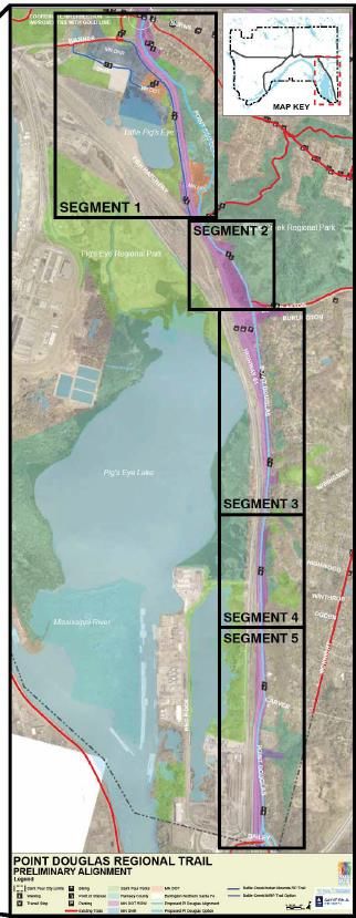
Mississippi River Trail (MRT) development in Minnesota is supported by MnDOT as one component of
their multi-modal transportation planning strategy. With its multiple connections to other riverfront trails
and its close river proximity, it is expected that the Point Douglas Regional Trail will become an
important segment of the existing MRT. The trail will also be part of the network of trails that lie in close
proximity to the river and within the National Park System's Mississippi National River and Recreation
Area (MNRRA). The trail will support a key NPS goal of increasing non-motorized access to the river for
park visitors as part of the MNRRA Alternative Transportation Plan.
Development Concept
The 4-mile Point Douglas Regional Trail, comprised of 5 segments, is located along the east side of
Hwy 61 mainly within the road right-of-way. Rest areas and amenities are strategically spaced every
half to one mile along corridor. The Point Douglas Regional Trail will include wayfinding and interpretive
signage from the City of Saint Paul Parks and Recreation comprehensive signage plan.
Segment 1
Segment 1 is separated into Segments 1A and 1B. Segment 1A and 1B is a 0.68 mile stretch of
separated trail located on the east side of Highway 61 road right-of-way. The trail follows the
decommissioned Point Douglas Road through deciduous forest connecting to a Battle Creek Regional
Park trailhead at Lower Afton Road. This trail alignment will require collaboration with MnDOT for future
improvements at Burns Avenue and Warner Road intersection.
A 1.37-mile interim alignment for Segment 1A is located on the west side of Highway 61 following the
existing Battle Creek and Indian Mounds Regional Park trail through MnDOT, Burlington Northern
Santa Fe (BNSF) Railroad, Minnesota Department of Natural Resources (DNR) properties, and
MnDOT road right-of-way along the west side of Highway 61. This existing trail connects to the Battle
Creek Regional Park trailhead at Lower Afton Road via a MnDOT underpass. When the preferred
alignment is constructed this interim trail alignment will remain since it is a park trail (Figure 4).

Page - 7 | METROPOLITAN COUNCIL
Figure 4. Segment 1 of the Point Douglas Regional Trail

Segment 2
Segment 2 is a 0.58 mile separated, off-street trail located on the Battle Creek Entrance Road. Steep
grades south of Segment 1 and overhead utility poles will require curb and bike lane removal to achieve
federal trail standards. The City and County will continue collaboration that may transfer ownership and
maintenance of the entire Battle Creek entrance road from the City to the County and include
installation of a vehicle barrier gate 200 feet north of Lower Afton Road. Segment 2 terminates at Lower
Afton Road. Intersection improvements at Lower Afton Road are required due to steep grades, poor
sightlines, high traffic speeds, and high traffic volumes (Figure 5).

Page - 8 | METROPOLITAN COUNCIL
Figure 5. Segment 2 of the Point Douglas Regional Trail

Page - 9 | METROPOLITAN COUNCIL
Segment 3
Segment 3 is divided into Segments 3A and 3B. Segment 3A is located on the west side of Point
Douglas Road within the road right-of-way separated from traffic by a boulevard, new curb, and tree
plantings. Segment 3B continues on the west side of Point Douglas Road separated from vehicles by a
boulevard, curb, and tree plantings. This segment includes a 0.25-mile portion that is narrow. The
short-term solution is to build a narrower grade separated trail within the MnDOT road right-of-way. The
long-term solution is to acquire private land and MnDOT road right-of-way to rebuild the Point Douglas
Road with an integrated separated trail facility (Figure 6).
Figure 6. Segment 3 of the Point Douglas Regional Trail

Segment 4
Segment 4 will utilize the existing protected, off-street trail between Highway 61 and the hillside. Due to
the proximity to Highway 61, the community engagement process recommended shifting the trail closer
to the hillside to allow for more vehicle separation while not affecting the hydrologic system.
Geophysical analysis will be required during the design phase to determine the suitability of the
bedrock to avoid impacts to the bluff. Coordination is needed with MnDOT to determine horizontal clear
zones from the roadway edge (Figure 7).

Page - 10 | METROPOLITAN COUNCIL
Figure 7. Segment 4 of the Point Douglas Regional Trail

Page - 11 | METROPOLITAN COUNCIL
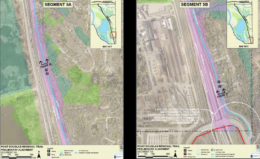
Segment 5
Segment 5 is a 1.2-mile segment that includes Segments 5A and 5B.
Segment 5A returns to the Point Douglas Road right-of-way as a protected, off-street trail separated by
a boulevard, curb, and tree plantings. Segment 5 continues on the Point Douglas Road right-of-way as
a protected, off-street trail until Stinchfield Street at which point the roadway and available right-of-way
narrows. This narrow section of the corridor will require a retaining wall on the west side of the trail and
relocation of the western curb line to the east.
This segment terminates at Bailey Road with an at-grade crossing to Washington County. Other
intersection improvements will be explored as the design develops (Figure 8).
Figure 8. Segment 5 of the Point Douglas Regional Trail

Conflicts
There are a number of conflicts that the master plan has responded to including utility relocation, slope
stabilization, and narrow road right-of-way.
All Segments: Utilities
Utilities along Point Douglas Road are within the road right-of-way and typically located behind the
curb. Some utilities such as water mains, storm and sanitary sewers will need to be relocated if the curb
line is moved. Continued coordination with Saint Paul Public Works and private utility owners is
needed.
Interim Segment 1: Slope Stabilization
The interim trail along west side of Highway 61 was recently reconstructed due to slope failure.
Subsurface drainage was determined to be the source of the slope instability and compacted free-

Page - 12 | METROPOLITAN COUNCIL
draining granular fill was recommended. Trail design along this interim segment will require
geotechnical analysis and structural design.
Segment 2: Lower Afton Road
Lower Afton Road is under Ramsey County’s jurisdiction. The intersection at Point Douglas Road is a
pedestrian and cyclist barrier because of high traffic speeds and high traffic volumes, steep grades from
the east, obstructed sightlines, proximity to Highway 61, and crossing length. During the design
process, this intersection was identified as one of the biggest barriers to use. Intersection
improvements will be explored in a later phase of development. Continued coordination is needed with
MnDOT and Ramsey County.
Segment 3B: Narrow Right-of-way
Midway through Segment 3, the road right-of-way narrows because of a swale between Highway 61
and Point Douglas Road. A retaining wall will be required to accommodate a trail that meets MnDOT
standards. Concrete jersey barriers separate Highway 61 from Point Douglas Road during this two-
block segment. The trail alignment will require an easement on private land to relocate the roadway to
the east.
Segment 5: Narrow Right-of-way
Sufficient right-of-way begins to narrow along Segment 5 south of Stinchfield Avenue because of an
existing drainage feature on the west side of the road. This narrow section of the corridor will require a
retaining wall on the west side of the trail, relocating utilities, relocating the curb to the east, and a
combination of parking restrictions and/or new parking bump-ins along the east curb. Continued
collaboration is needed with Saint Paul Public Works to meet federal trail standards, the functional
needs of the roadway, and functional needs of the stormwater system (swale). Finally, public
engagement recommended to keep existing trees on the west side of Point Douglas to reduce industrial
and vehicle pollution. A tree inventory, preservation, and removal plan will be required during the
design phase to determine tree loss and replacements due to retaining wall installation.
Segment 5: Bailey Road Intersection Crossing
Bailey Road is under jurisdiction of both MnDOT and Washington County. Similar to Lower Afton Road,
the intersection at Bailey and Point Douglas is a pedestrian and cyclist barrier because of high traffic
speeds, high traffic volumes, steep grades from the east that increase vehicle speeds, obstructed
sightlines, and crossing length. Intersection improvements will be explored in a later phase of
development. Continued coordination is needed with MnDOT and Washington County.
Public Services
Public services needed to implement the Point Douglas Regional Trail include utility relocations, road
changes, and intersection improvements. Trail segments 2, 3, & 5 will affect existing regional
wastewater, local water, and electrical utilities. In addition, the trail will shift the road alignment to the
east in Segment 3. And lastly, intersection improvements are identified for safe trail crossings at Afton
Road and Bailey Road.
Operations
The new trail will cost $36,756 annually for maintenance. All regional trails within Saint Paul are
included in the park operations and maintenance budget. This includes annual assessment of the trail
conditions, repair, and renovation of the trail components as needed. The completed Point Douglas

Page - 13 | METROPOLITAN COUNCIL
Regional Trail will be included in the normal operations and maintenance cycle funded in part with
Regional Park System Operation and Maintenance funding.
Partner Engagement
The City involved a number of organizations in the development of the master plan, as discussed
below; and there were no major concerns or opposition. The partners valued the need to improve the
existing corridor. City of Saint Paul Parks and Recreation and Public Works Departments collaborated
on the future improvements, and it was widely agreed to continue discussions to meet federal trail
standards, functional needs of the roadway, and maintenance responsibilities.
DNR, BNSF, MnDOT: The existing interim trail alignment was constructed on both public and privately
owned lands. The city is currently in the process of renewing or securing limited use permits from each
landowner. In some cases, a limited use permit cannot be executed until design plans can be
submitted. On-going collaboration is needed.
Ramsey and Washington County: Several agency meetings were held with Ramsey and Washington
Counties to coordinate bicycle and pedestrian connections to multiple neighborhoods and intersection
crossings. It was agreed by all agencies that continued collaboration is needed during the design
process. Ramsey County also conducted a multi-year community input process during the development
of the Battle Creek Master Plan and identified future trail connections to the Point Douglas Regional
Trail. The City and County will continue collaboration that may transfer ownership and maintenance of
the entire Battle Creek Entrance Road including a vehicle barrier gate 200 feet north of Lower Afton
Road to the County. Additionally, Ramsey County is planning to make a boundary adjustment at Battle
Creek Regional Park, which would potentially provide numerous connection points with the Point
Douglas Regional Trail, including at Fish Creek Road. Washington County was aware of the process
and provided review and comment of the draft master plan document.
Ramsey-Washington Metro Watershed: Implementation of the trail will likely require adherence to
Ramsey-Washington Metro Watershed’s best management rules and coordination on future grants.
Additionally, the trail alignment and master plan document was presented to and received approval
from multiple boards as listed below.
   •   Southeast Community Organization (District 1)
   •   Saint Paul Transportation Commission
   •   Parks and Recreation Commission
   •   Saint Paul City Council

Public Engagement and Participation
The master plan was developed in response to a robust public engagement process, as well as past
planning engagement processes.
The City of Saint Paul started community engagement in March 2020 with a survey and interactive
map. The project was delayed for 6 months due to the pandemic and community engagement resumed
in October 2020 with two virtual presentations, two virtual focus group meetings, a door-to-door flyer
distribution, and posting on social medial sites. A design advisory committee was also convened to
represent residents, local stakeholders, and residents of District 1 and Ward 7.
The following are goals and objectives identified during the public planning process:
   •   Maintenance: Trail must accommodate winter snow removal.
   •   Safety: Improve intersection crossing at Warner, Lower Afton, Highwood, and Bailey roads.

Page - 14 | METROPOLITAN COUNCIL
•   Safety/Security: Improve safety and security with lighting.
   •   Alignment: Trail corridor should be located on west side of Point Douglas Road versus east
       side.
   •   Signage: Improve wayfinding signs to major destinations and make local connections.

Equity Analysis
Saint Paul Parks conducted an equity analysis as part of the master plan process for the trail. The
analysis included information on the project data, public engagement and participation, and an
evaluation summary.
Project Data
The Point Douglas Regional Trail will connect the communities of District 1 (Southeast Community
Organization) to local amenities, downtown, and Washington County. District 1’s community general
demographics include 56.3% people of color and 43.7% people who are white. The specific
demographics of people of color are: 25.5% Black or African American, 22.4% Asian or Pacific Islander
8.8% Hispanic or Latino, 4.3% two or more races.
According to District 1's Equity Plan, 1 in 10 people were a person of color in 1990. Today, 6 in 10
people living in District 1 are people of color. This cultural and racial diversity is also expected to
increase. In addition, the City of Saint Paul 's 2040 Comprehensive Plan says District 1 has some of the
highest percentages of children and people of color.
Saint Paul’s comprehensive plan identifies a social equity priority to reduce barriers to Parks and
Recreation facilities and create programming to address financial, physical, language and perception
barriers. According to Metropolitan Council’s Adventure Close to Home: Connecting Youth with the
Regional Park System report present-day barriers include three types of safety concerns: nature and
remoteness, strangers, and law enforcement. Of those barriers listed, remoteness, park inclusivity, and
awareness are present-day barriers that can be identified along the Point Douglas Trail corridor for
underserved populations. Specifically, the long, linear nature of trails can result in a feeling of
remoteness, the lack of multilingual signs and cultural history can lead to inclusivity concerns, and the
lack of a dedicated wayfinding and amenities can lead to awareness issues. Saint Paul’s District 1
community expressed concerns regarding the disproportionate burden of this underinvestment in Parks
including trail infrastructure. Additionally, a blog by the National Recreation and Park Association:
Understanding Equity in Parks and Recreation, documents similar cases of park usage and access by
underserved communities because of underinvestment.
Public Engagement and Participation
A new approach was developed by customizing a community engagement plan for the Somali
community (Horn of Africa Community), teens (St. Paul Youth Commission), and students. The level of
engagement was to "Involve" as identified by the International Association for Public Participation
Spectrum. For example, participants commented on the proposed trail alignments and amenities.
Engagement opportunities consisted of physical mailings to residents immediately adjacent to the trail,
pop-up meetings at public spaces in the community (trailheads & events), website updates, e-blasts,
virtual meetings, and virtual presentations. The advice received during community engagement was
summarized by the following stakeholder groups.
District 1’s Somali community: One of the highest housing densities also corresponded to the highest
percentages of children and people of color. The project planning team reached out to the Horn of
Africa Community and local businesses. The project team learned that the Somali community primarily

Page - 15 | METROPOLITAN COUNCIL
communicates verbally compared to electronic means such as email, Facebook, or web pages. In
coordination with the community group and local businesses, the project team distributed surveys door-
to-door to known Somali homes and businesses. The survey was translated to Somali and the
community leaders assisted with translation services (if needed). Survey responses revealed that even
though the trail corridor is adjacent to many families of color, many people didn't know about the
proposed trail. The community engagement process itself began to solve an unknown barrier which
was the trail identity. Also, responses suggested future trail promotion, programming, and multilingual
information is needed to encourage trail use, trail ownership, and to celebrate a shared amenity (grand
opening).
Saint Paul Youth Commission: The Saint Paul Youth Commission consists of a diverse group of 10-12
youth between the grades of 9 and 12. The Youth Commission recommended the project team
distribute an electronic survey to the nearby Harding High School. The survey responses reflected the
District 1 demographics. A majority of the high school respondents said the lack of trail identity was the
one of the biggest barriers to use. Many people did not know about the existing, interim trail. The
results also suggested that site amenities such as benches, signage, and drinking fountains would
entice them to use the trail.
Evaluation Summary
Feedback received guided the development of the master plan and reinforced the need of the
community to make the trail more safe, accessible, and accommodating. The following are
recommendations from the community by theme:
• Community: Promote the proposed trail alignment and organize a grand opening to celebrate a
shared public amenity.
• Community: Provide multilingual information (signs, maps) and provide interpretation of
underrepresented groups (Dakota, Somali).
• Infrastructure: Increase safety by improving lighting, trail surfacing, and separation from vehicle
traffic.
• Infrastructure: Increase access by improving connections across intersections and to local and
regional destinations.
• Amenities: Increase demand by providing amenities such as shade, lighting, benches,
multilingual signage, and drinking fountains.
The planning process identified District 1 has some of the highest percentages of children and people
of color in Saint Paul. It also identified present-day barriers for underserved communities including
underinvestment in recreation, lack of trail awareness and inclusivity concerns. To account for this
disproportionate investment, the planning process developed strategies based upon feedback from
community leaders including youth and the Somali community (Horn of Africa Community) to create a
trail that is inclusive and equitable for people of all races, ages, and abilities
The lack of awareness of the existing interim alignment of the Point Douglas Regional Trail is a
significant barrier that prevents underserved communities from identifying with their community, parks
and recreational facilities. The proposed master plan's development concepts and public services seek
to transform the corridor into a recreational amenity that feels safe, relates to community cultures, and
creates a sense of place.
Feedback from public engagement informed the planning process by suggesting multilingual text,
cultural interpretation, promoting the trail as a shared public amenity, increasing safety through a grade
separated trail, and providing comfort amenities. Overall, the planning process helped to establish
Page - 16 | METROPOLITAN COUNCILrelationships with students, residents, local government, and state agencies. The relationships developed will provide a conduit to relay future communication and project updates. Compared to previous planning studies, the project reached more individuals through virtual presentations on social media sites. This required the project team to increase project awareness by reengaging a broader demographic including people of color and low-income residents. Public Awareness As part of the community engagement plan, the Point Douglas Regional Trail gained public awareness via social media, direct email, and postcard flyers. Once complete, the trail will be promoted through Saint Paul web pages, print brochures, and other trail related publications. Additionally, the Point Douglas Regional Trail is located within the National Parks Service Mississippi National River and Recreation Area (MNRRA) The Point Douglas Regional Trail and surrounding amenities are identified in the Mississippi River Companion, a publication guide to navigate the MNRRA. The National Park Service conducts a regular "Bike with a Ranger" event to learn and explore the MNRRA. Saint Paul may consider partnering with the NPS to program a "Bike with a Ranger" event in conjunction with the grand opening of the trail Mississippi River Trail. MnDOT also continues to support and expand the Point Douglas Regional Trail as part of the Mississippi River Trail (MRT). This includes a commitment to support MRT improvement projects and to publicize the trail through the development of the Mississippi River Trail Bikeway Marketing Toolbox. The toolbox assists communities with bicycle tourism and to promote the route. Public Services The proposed trail along segments 2, 3, & 5 will follow the curb line affecting existing sewer, water, and electrical utilities. In addition, the development concept proposes to shift the road alignment to the east in Segment 3. All of these utilities are included in the development cost and will occur at the beginning of the project, prior to the construction of the regional trail. Further utility coordination is needed with Saint Paul Water, Saint Paul Public Works, the Metropolitan Council Environmental Services, and MnDOT. Accessibility All park facilities will be developed in accordance with the Americans with Disabilities Act (ADA). Other local guidelines, such as the DNR's Trail Planning, Design and Development resource book, and the MnDOT Bicycle Facility Design Manual will be used when developing accessible bicycle and pedestrian facilities including trail surfaces, street crossings, and the bridge connection in South Saint Paul. The community highlighted several accessibility issues along the corridor including barriers to crossing intersections, uneven roadways currently used as a shared pedestrian/vehicle route and lack of directional wayfinding. A dedicated off-street multi-use trail will resolve these issues and transform Point Douglas into a pedestrian oriented corridor. Mississippi River Corridor Critical Area The Point Douglas trail is located within Mississippi River Corridor Critical Area (MRCCA) is a State- designated land corridor along 72 miles of the Mississippi River in the Twin Cities Metropolitan Area. Several trail segments, most notably Segment 4, are located within the bluff impact zone. MRCCA design guidelines will be followed during the design process. Page - 17 | METROPOLITAN COUNCIL
Consistency with Other Council Policies and Systems
Environmental Services – Sewers (Roger Janzig, 651-602-1119) – The City of St. Paul has
submitted the Saint Paul Point Douglas Regional Trail Master Plan for review. The construction of any
new or updating of existing paths, trails, bridges, or any other construction project may have an impact
on multiple Metropolitan Council Interceptors in multiple locations. To obtain an Encroachment
Agreement Application, and to assess the potential impacts to our Interceptor System, contact Tim
Wedin, Interceptor Engineering Assistant Manager (651-602-4571) at the Metropolitan Council
Environmental Services; and prior to initiating any project, preliminary plans should be sent for review.
Metro Transit (Steve Mahowald, 612- 349.7775 ) – Refer to the Metro Transit interactive map for
updated bus locations (https://www.metrotransit.org/schedules-maps). Proposed future transit locations
will need close collaboration between Saint Paul and Metro Transit.
Environmental Services – Water Resources (Maureen Hoffman, 651-602-1279) - Council Staff
advise that during the planning and construction of the trail that the city cooperates with road authorities
and that all stormwater requirements are met to the best extent possible.

Page - 18 | METROPOLITAN COUNCIL
Attachment 1. Saint Paul City Council Resolution 22-49

Page - 19 | METROPOLITAN COUNCIL
Attachment 1. (Continued) An image of Saint Paul City Council Resolution 22-49

Page - 20 | METROPOLITAN COUNCIL
You can also read