MAPP KELP MONITORING METHODS 2021 - MARINE PLAN PARTNERSHIP FOR THE NORTH PACIFIC COAST (MAPP)
←
→
Page content transcription
If your browser does not render page correctly, please read the page content below
Marine Plan Partnership for the North Pacific Coast (MaPP)

MAPP KELP MONITORING METHODS 2021

                                                           Updated: July 2021

                                                                           1
     Marine Plan Partnership for the North Pacific Coast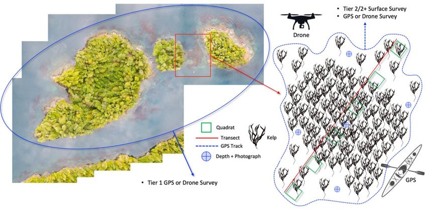
Disclaimers:

The purpose of this document is to support the MaPP Partners to conduct kelp monitoring training, field work
and data collection and to provide guidance and examples for other organizations or practitioners wishing to
conduct kelp monitoring. Users of this document should review and implement their organizational safety
protocols as required prior to conducting monitoring in the field.

This document and the statements within have not been formally reviewed or approved by the organization(s)
representing the Provincial Government or First Nations' governments. They are presented for discussion
purposes only and are subject to change upon formal review and revision. The MaPP Partners and contractors or
anyone else connected with MaPP, in any way whatsoever, are not responsible for use of the information
contained in this document.

Citation:
Thompson, Markus (2021) MaPP Kelp Monitoring Protocol. Marine Plan Partnership.

Prepared by:
 Markus Thompson
 Thalassia Environmental
 Quadra Island, BC
 markus@thalassia.ca

Prepared for:
 Marine Plan Partnership Initiative (MaPP)

 This document will be updated as necessary

                        Marine Plan Partnership for the North Pacific Coast
Canopy Kelp Monitoring Overview

Canopy kelp monitoring requires a blend of Tier 1 (p.3) and Tier 2/2+ (p.4) survey methods:
   • Tier 1 methods are designed for the first field season of surveying to efficiently collect baseline
       information (kelp location and extent) over large coastal areas. Observations from Tier 1 surveys
       build local ecological knowledge and provide the informati on required to map and select
       ecologically important kelp beds for subsequent Tier 2/2+ surveys.
   • Tier 2/2+ methods collect detailed observations from preselected kelp beds, including measures of
       spatial coverage and kelp density (Tier 2), species ID, ocea nographic parameters, and high-
       resolution UAV images (Tier 2+). Where time allows, Tier 1 methods can be paired with Tier 2/2+
       surveys to collect additional observations (see Figure 1 below).

– – – – – –– – – –– – – –– – – –– – – –– – – – –– – – –– – – –– – – –– – – –– – – – –– – – –– – – –– – – –– – – –– – – –– – – – –– – – –– – – –– – – –– –– – – – – –– – – –– – – –– – – –– – – –– – – – –– – – –– – – –– – – –– – – –– – – – –– – – –– – – –– – – –– – – –– – – –– – – – –– – – –– – – –– – –

  Figure 1: Surface view (top) and aerial view (bottom) examples of Tier 1 and 2 canopy kelp surveys.

                                                                                                                                                                                                                                                                                                          2
                                                        Marine Plan Partnership for the North Pacific Coast
Tier 1 Kelp Monitoring Methods

Tier 1 Step 1: Kelp reference information
    • Location mapping should be completed at tides below 2.5m.
    • Kelp bed definition guidelines:
             o A cluster of bull kelp or giant kelp spanning ~3 metres or more in any direction.
             o Gaps greater than ~10 metres between plants separate individual kelp clusters / beds.
    • Use a data collection app (e.g.: Avenza, Coast Tracker) or the datasheet to record reference information:
             o Date, Time, and Tide.
             o Kelp species (bull kelp, giant kelp, or mixed kelp bed).
             o Guardian crew, and names of Guardians collecting data.
             o Site location: name of the island, bay, or other nearby identifiable location.
             o Site Identification: provide a unique identification number for each site. For example, the first
                 Tlowitsis kelp survey could be identified as TL–K01 (Tlowitsis – Kelp Bed number 1).

Tier 1 Step 2: Map the extent or perimeter of the kelp bed
    • Use a data collection app or the datasheet to map the location of kelp with GPS points:
    • For kelp fringing the shoreline: map the offshore edge with GPS points (enough to connect the dots and
         show the edge on a map) and record width (distance across the kelp to the shoreline) at each GPS point.
             o Example: map the kelp along a curving coastline by placing a GPS point at each location where
                  the shoreline curves (e.g.: along an S shaped coastline record GPS points on the inside and
                  outside of each curve, this will allow you to connect the dots on a map, retracing the kelp).
    • For kelp bed reefs map the perimeter with enough GPS points to record the general shape.
             o Example: map a circular bed with 4 GPS points – inshore, offshore, left and right sides.
                  Irregularly shaped beds should include additional points to record the general shape (width
                  measurements are not required here as we can later measure the width with the GPS points).
    • Estimate the density (percent coverage) of the kelp bed observed at each GPS point using a score from 1
         to 5 (very low to very high):

Option: UAV (drone) survey for kelp bed extent mapping
   • Tier 1 drone surveys are most feasible when conducted with Tier 2/2+ surveys: map a preselected area
        around the Tier 2 kelp bed (Figure 1) using the drone to map perimeter extent (Step 2). Detailed local
        information collected with Tier 2 surveys is complemented with the Tier 1 survey in adjacent areas.
   • Refer to Tier 2: Step 7 and the Guide for Drone Surveys for detailed instructions.

Tier 1 Step 3: Comments and photographs.
    • Use a data collection app or the datasheet to provide informative comments.
             o Brief description: informative details not included in steps 1 and 2 (fringe or reef; proximity to
                 human activities; exposed or sheltered; notable impacts).
             o Substrate – bedrock, boulder, cobble, pebble, and sand (note primary and secondary).
             o Bryozoans (present / absent). Sea urchins (species, present / absent).
             o Other species observed – schools of fish, predators (sea lions, otters, etc.).

                                                                                                                    3
                     Marine Plan Partnership for the North Pacific Coast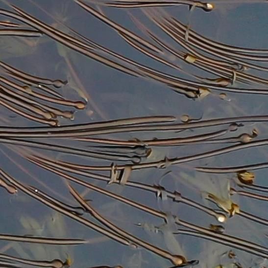
Tier 2 / Tier 2+ Kelp Monitoring Methods

Tier 2 Step 1: Kelp reference information.
    • Spatial mapping and data collection should be completed at tides below 1.5m
    • Kelp bed selection: The selected kelp bed should be large enough to complete a minimum of 10
         quadrats. If the selected kelp bed is not adequate in size, move to the nearest adequate kelp bed.
             o If the entire kelp bed cannot be surveyed due to size, select a representative area that can be
                 surveyed within the 2-hour tide window (1 hour before and 1 hour after the low tide).
    • Use a data collection app (e.g.: Avenza, Coast Tracker) or the datasheet to record reference information:
             o Site Identification: provide a unique identification number for each site. For example, the first
                 Tlowitsis kelp survey could be identified as TL–K01 (for Tlowitsis – Kelp Bed number 1).
             o Location – record a brief description of the kelp bed location. For example: ‘south side of Cook
                 Island in Beware Passage’.
             o Site GPS coordinate – position the boat to record a UTM coordinate that can be used to find the
                 kelp bed again. Set the GPS to NAD 83, UTM, and decimal degrees. Record the coordinates using
                 a data collection app or the datasheet. For example: 50.589038, -126.863560.
             o Guardian crew, and name of Guardian recording the data.
             o Weather – record marine weather conditions (wind, current, waves, etc.).
             o Substrate – bedrock, boulder, cobble, pebble, and sand cover (primary and secondary).
             o Tide – record the time and tide when you start and when you complete the survey.
             o Species observed – schools of fish, predators (sea lions, sea otters, etc.).
             o Sea urchins – species (red, purple, or green), and estimated abundance for each within the site
                 (abundance guidelines: high: > 3/m2, medium: 1–2/m2, low: < 1/m2).
    • Refer to Checklist (p. 7) for guidance on differences between Tier 2 and Tier 2+.

Tier 2 Step 2: Set-up transects and mark their locations
Identify representative transects (an imaginary line spanning the kelp) through the kelp bed. Set one or more
straight lines (transects) across the kelp bed that include similar proportions (high and low area of density) of
kelp when compared to the entire bed (see below and Figure 2).
    • Multiple transects should be used when necessary. For large kelp beds, complete as many quadrats as
         time will allow (while the tide is below 1.5m).
    • Record GPS points and the depth at the beginning and end of each transect.
    • Use a handheld GPS, data collection app, or the boat sounder to record a GPS points at the start of each
         transect (Transect 1 start = T1a) and end (Transect 1 end = T1b).
         o Use a small inflatable boat, punt, or kayak to get into the kelp bed if needed.
    • Use a depth sounder or a drop line to record the depth at the beginning and end of each transect.

                                                                                                                4
                     Marine Plan Partnership for the North Pacific Coast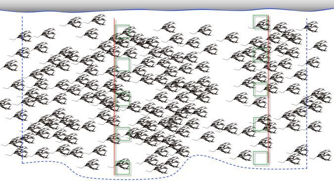
Tier 2 Step 3: Collect quadrat data along the transect

   Bull kelp (Nereocystis luetkeana)
   • Use a 1 m2 quadrat to count and measure kelp bulbs along the transect.
            o Count all of the kelp bulbs found inside the quadrat on the water surface.
            o Estimate bryozoan coverage using a score from 0.5 to 5 (note the added 0.5 category):

   •    Measure the diameter of up to 10 kelp stipes at their widest point (typically ~10cm below the bulb)
        using calipers (e.g.: 28 mm). Only measure stipes that are attached to bulbs inside the quadrat.
            o Flip the quadrat 3 times to move 3 meters along the transect to reach the next quadrat location.

   Giant kelp (Macrocystis pyrifera)
   • Use a 1 m2 quadrat to count kelp fronds along the transect.
           o Place the transect perpendicular to the direction fronds are sitting in the current to ensure you
                don’t count the same individual fronds again in multiple quadrat locations (if your transect
                points in the same direction as the kelp fronds, the same fronds may be counted 2 or 3 times).
           o If more than 1 transect is needed, additional transects must be separated by a minimum of 6m.
           o Flip the quadrat 3 times to move 3 meters along the transect to reach the next quadrat location.
           o Count kelp fronds (one frond = a single branch, including all attached floats and blades) that are
                inside the quadrat, on the surface (counts will vary from 0 to 60+).
           o Estimate bryozoan coverage observed on the kelp in each quadrat using a score from 1 to 5
                (very low to very high):

   Mixed (giant kelp + bull kelp)
   • Complete quadrat counts (Step 2) separately for each species.

Tier 2 Step 4: Map the extent or perimeter of the kelp bed

Option: UAV (drone) survey
   • Use your drone to record survey images of the entire kelp bed from a height of 60–120m (Tier 2+).
           o Adjust height based on size of survey area, tree heights, weather, etc.
           o It is very important to be sure the entire kelp bed has been surveyed.

                                                                                                              5
                     Marine Plan Partnership for the North Pacific Coast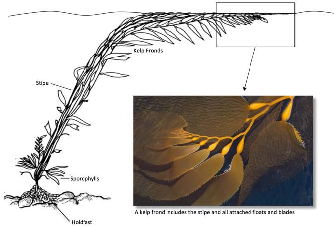
•   If time and battery power allow, use your drone to record survey images of kelp surrounding the survey
       area from a height of 120m (see Figure 1).
            o Open the Pix4D app to review the areas selected for the survey (this area should be planned and
                selected before you leave for the field). You can adjust the area the drone will survey if you
                suspect that any part of the kelp bed might fall outside of the preplanned survey area.
            o Check battery levels on all devices and ensure an adequate SD card is onboard.
            o Check conditions (weather, tides, lighting, and safety).
            o Ensure air space is clear and flight altitudes will be enough to clear trees.
            o Test lighting levels and focus of the camera by taking test photos.
            o Start and end your flight using the DJI GO 4 app. Fly the mission with Pix4D.
            o Complete your flight log, including start and end times, weather conditions, and crew.
   •   Refer to the Guide for Drone Surveys for detailed instructions.

Option: GPS survey (when a drone survey is not possible)
   • If you cannot complete a drone survey, map the kelp bed perimeter using GPS.
           o Use a kayak, inflatable, or punt to move around the kelp bed while recording a GPS track or GPS
               points. Stay within 1m of the kelp bed edge (see Figure 2).
   • Draw a map of the kelp bed.
           o Identify areas where transects were positioned and where CTD measurements were taken.
           o Identify areas on the map that contain continuous distribution (unbroken surface coverage) and
               areas that contain patchy distribution (uneven, fragmented coverage). Estimate the density
               (percent coverage) of the kelp bed in each area identified on the map using a score from 1 to 5.

Tier 2+ Step 5: Oceanographic data.
    • Use a CTD water quality instrument to measure temperature and salinity at –1m, –5m, and –10m.
            o Measurements should be recorded near the center of the bed via kayak, if possible.
    • Use the Secchi disk to measure water visibility.
            o Record the depth (marked on the Secchi line) where the disk is no longer visible.
    • Record a GPS point where you measured oceanographic parameters using a GPS or data collection app.

Tier 2+ Step 6: Kelp bed observations.
    • Use a smart phone, tablet, or data collection app to record photographs and observations, including
        notable comments on health and the presence of wildlife.
    • Record the presence and abundance of kelp-encrusting bryozoans (thin, circular colonies of white crust).
            o Use guidelines in Step 2: Bull Kelp (p.4) to estimate average cover for the entire bed.
    • Record underwater observations: from the boat, using a drop camera, or mask and snorkel.
            o Urchin species (red, purple, green) and abundance (high: > 3/m2, medium: 1–2/m2, low: 1/m2).
            o Sea star and rockfish species (use an ID book for identification).
            o Substrate type: bedrock, boulder, cobble, pebble, and sand cover (note primary and secondary).
    • Take wide angle photographs that are representative of the kelp bed. (see Figure 2 for photo locations).

                                                                                                              6
                    Marine Plan Partnership for the North Pacific Coast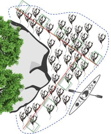
Survey Guidelines and Checklist
Survey Data Guidelines and Checklist:

    •     Record all measurements in metric (meters, centimeters, and millimeters).
               o Set all relevant equipment to metric: DJI GO 4, YSI, depth sounder, range finder, etc.
    •     Record all GPS points in Decimal Degrees (i.e.: 50.589038, -126.863560).
               o Set all relevant equipment to decimal degrees: Avenza, depth sounder, etc.
    •     All data from the same site must include the same Identification number (i.e.: TL-K001).
               o The site ID number must be recorded with each method used for data collection (Table 1).

Tier 1:
    o     Fill in all kelp reference information

    o     GPS points recorded in a data collection app or datasheet, including width and density estimates

    o     Notes recorded on species, habitat, and substrate (include photographs if needed)
Tier 2:
    o     Fill in all kelp reference information

    o     Quadrat counts and kelp measurements recorded on the data sheet

    o     Record kelp bed perimeter GPS points using a GPS unit or data collection app (boat survey option)

    o     UAV survey of the entire kelp bed completed / flight log completed (drone survey option)

    o     Survey start and end times recorded, including estimated tide elevations
Tier 2+ add-ons:
    o     Oceanographic data (temperature and salinity) recorded at -1, -5, and -10m using the CTD

    o     Visibility recorded using the Secchi Disk

    o     Depth, width, and substrate recorded at selected locations throughout the kelp bed

    o     Drop camera observations recorded, including urchin presence and abundance

    o     Photographs (surface and UAV) and notes on species and habitat recorded
UAV:
    o     Survey is planned in Pix4D before leaving for fieldwork / adjusted in the field if needed

    o     Before flight: batteries are fully charged + SD card has adequate space

    o     After flight: photos are in focus + survey area has been covered

                                                                                                              7
                       Marine Plan Partnership for the North Pacific Coast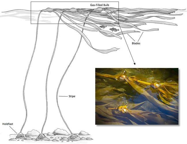
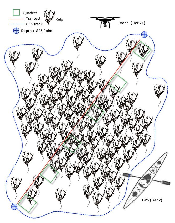
Figure 2: Tier 2 kelp bed mapping. Step 1: record location and site ID. Step 2: using transects and quadrats count
and measure kelp stipes (bull kelp) or fronds (giant kelp) + estimate bryozoan percent cover. Step 3: record the
location and depth of each transect. Step 4: use the CTD instrument to record temperature and salinity. Step 5:
record key observations, including species (urchins, sea stars, and marine mammals), kelp condition, and
substrate. Step 6: complete an aerial survey using Pix4D, or map the kelp bed perimeter with GPS.

                                                                                                                 8
                     Marine Plan Partnership for the North Pacific Coast
Appendix 1: Kelp overview and identification

•   Canopy kelps are large seaweeds that form the canopies of dense marine kelp forests along British
    Columbia’s coastline. Kelp forests are typically found in rocky subtidal areas along semi-exposed shorelines
    up to 10 m deep. These habitats are often composed of multiple species that form a three-dimensional
    community structure, including benthic, understory, and canopy layers. The dominant canopy species found
    in the North Vancouver Island region are bull kelp (Nereocystis luetkeana) and giant kelp (Macrocystis
    pyrifera).

•   Bull kelp is an annual seaweed (growing from spore to maturity in a single year) that can reach over 20 m in
    length. Each plant is composed of a holdfast anchoring the plant to the seafloor, a long flexible stipe, a
    single gas-filled float, and long narrow blades that form the surface canopy. Reproduction in bull kelp
    occurs when patches of spores (sori) are released from reproductive blades, settling on nearby rocky
    substrate. Fully matured bull kelp is typically washed away in winter storms, creating space for the growth
    of new plants in the following year. Under optimal conditions kelp can grow up to 25 cm per day.

Figure A1: Bull kelp (Nereocystis luetkeana) identification.

•   Giant kelp is a perennial seaweed (persisting for multiple years) that can grow to 30 m in length. Each plant
    is composed of a cone-shaped mass of branching haptera (a holdfast) anchoring the plant to the seafloor,

                                                                                                                9
                     Marine Plan Partnership for the North Pacific Coast
and multiple branching vine-like fronds; each frond includes a single stipe many gas-filled floats and blades,
pulling the plant to the surface where it forms a dense canopy. Reproduction in giant kelp occurs when
specialized blades (sporophylls) release spores that settle on rocky substrate. Under optimal conditions
giant kelp can grow up to 35 cm per day.
Figure A2: Giant kelp (Macrocystis pyrifera) identification.
• Bull kelp is common throughout the entire North Vancouver Island region, from Quadra Island in the south
to Cape Scott in the north; the distribution of giant kelp is restricted to the Queen Charlotte Strait, from
Malcolm Island to Cape Scott.
• Canopy kelps were selected as MaPP indicator species for their ecological value and sensitivity to shifts in
oceanographic conditions and human pressures. Kelp forests provide food and shelter for an extensive
range of marine life, including marine mammals, birds, and many species of commercially important fish
and shellfish. Canopy kelps provide the architecture for these dynamic kelp forest habitats, shifting their
distribution and density with changes in temperature, salinity, turbidity, marine weather, and grazing
pressure. Sensitivity to oceanographic conditions also make canopy kelps an ideal indicator for tracking the
effects of climate change.
10
Marine Plan Partnership for the North Pacific CoastReferences:
Bishop, E. (2014). A kayak-based survey protocol for Bull Kelp in Puget Sound Prepared for the Northwest Straits
Commission. National Oceanic and Atmospheric Adminstration, (October), 26.
Coastal Ocean Research Institute. (2018). MaPP Pilot Regional Indicators Phase 2: Kelp report # 1.
O’Neill, J. (2015). Spatial temporal extent of bull kelp (Nereocystis leutkeana) floating canopy area on the west
coast of Canada. Salish Sea Marine Survival Project, 1–39.
Pfister, C. A., Berry, H. D., & Mumford, T. (2017). The dynamics of Kelp Forests in the Northeast Pacific Ocean
and the relationship with environmental drivers. Journal of Ecology, (June), 1–14.
Springer, Y., Hays, C., Carr, M., Mackey, M., & Bloeser, J. (2006). Ecology and management of the bull kelp,
Nereocystis luetkeana: A synthesis with recommendations for future research. LenFest Ocean Program, 1–53.
Resources:
MaPP marine plan portal: www.seasketch.org
BC marine conservation atlas: www.bcmca.ca
ShoreZone coastal habitat mapping system: www.shorezone.org
Biodiversity of the Central Coast: www.centralcoastbiodiversity.org
Global algae database: www.algaebase.org
Equipment List:
• Kelp field manual
• Waterproof notebooks, datasheets, and pencils
• Tablet / iPad equipped with a data collection app.
• Tide table (printed or electronic)
• Species ID book
• Binoculars
• 100 x 100 cm quadrats (1.0m2)
• Data collection boat (inflatable, punt, canoe, or kayak)
• Weighted tape or drop line for measuring depth
• CTD instrument (for temperature and salinity measurements)
• Drop Camera
• DJI Phantom or Mavic UAV
• Rangefinder
• Secchi disk
11
Marine Plan Partnership for the North Pacific CoastMarine Plan Partnership for the North Pacific Coast
Tier 2 – Bull Kelp (Nereocystis) Monitoring Datasheet
Site ID + Location:                                               Weather:                                                    Low Tide:            Time:
Site GPS:                                                        Substrate:                                                   Survey      Time      Current      Tide
Date:                                                            Species:                                                     Start
Crew:                                                            Urchins:                                                     End
Transect Locations                                                                                                            Oceanographic Data
Point Depth            GPS                              Point    Depth             GPS                                        GPS:
T1a                                                     T3b                                                                   Depth       Temperature      Salinity
T1b                                                     T4a                                                                      –1m
T2a                                                     T4b                                                                      –5m
T2b                                                     T5a                                                                      –10m
T3a                                                     T5b                                                                   Secchi Disk:
Quadrat Data
Quadrat    % Bryozoans # Bulbs   Stipe Diameter (10)                               Quadrat    % Bryozoans # Bulbs   Stipe Diameter (10)
      1                                                                               21
      2                                                                               22
      3                                                                               23
      4                                                                               24
      5                                                                               25
      6                                                                               26
      7                                                                               27
      8                                                                               28
      9                                                                               29
      10                                                                              30
      11                                                                              31
      12                                                                              32
      13                                                                              33
      14                                                                              34
      15                                                                              35
      16                                                                              36
      17                                                                              37
      18                                                                              38
      19                                                                              39
      20                                                                              40

                                                                                                                                                                        13
                         Marine Plan Partnership for the North Pacific Coast
Tier 2 – Giant Kelp (Marcrocystis) Monitoring Datasheet
Site ID + Location: Weather: Low Tide: Time:
Site GPS: Substrate: Survey Time Current Tide
Date: Species: Start
Crew: Urchins: End
Perimeter Data Oceanographic Data
Point Depth GPS Point Depth GPS GPS:
T1a T3b Depth Temperature Salinity
T1b T4a –1m
T2a T4b –5m
T2b T5a –10m
T3a T5b Secchi Disk:
Quadrat Data
Quadrat # Fronds % Bryozoans Quadrat # Fronds % Bryozoans Quadrat # Fronds % Bryozoans Quadrat # Fronds % Bryozoans
1 21 41 61
2 22 42 62
3 23 43 63
4 24 44 64
5 25 45 65
6 26 46 66
7 27 47 67
8 28 48 68
9 29 49 69
10 30 50 70
11 31 51 71
12 32 52 72
13 33 53 73
14 34 54 74
15 35 55 75
16 36 56 76
17 37 57 77
18 38 58 78
19 39 59 79
20 40 60 80
14
Marine Plan Partnership for the North Pacific CoastKelp Density Estimation Examples
5. Very high density: 80–100 percent coverage. 4. High density: 60–80 percent coverage. 3. Medium density: 40–60 percent coverage.
Continuous and unbroken.
2. Low density: 20–40 percent coverage. 1. Very low density: < 20 percent coverage.
Patchy and fragmented.
15
Marine Plan Partnership for the North Pacific CoastYou can also read