Lavaca County Situation Awareness Brief Monday, August 2, 2021 as of 3:00 PM CDT - Prepared By: Egon Barthels | Emergency Management Coordinator
←
→
Page content transcription
If your browser does not render page correctly, please read the page content below
Lavaca County Situation Awareness Brief
Monday, August 2, 2021 as of 3:00 PM CDT

                   Prepared By: Egon Barthels | Emergency Management Coordinator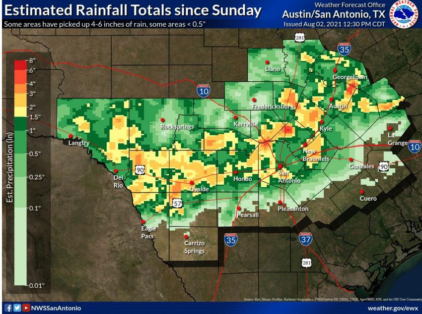
Emergency Operations Center (EOC)

• OPERATIONAL PRIORITIES:

• 1. Protect life and property.
• 2. Support rapid & effective response.
• 3. Collect and disseminate accurate incident information to improve decision making.
• 4. Accurately track incident costs associated with assigned resources for
• cost recovery.

  Lavaca County Emergency Operations Center (EOC) is at Level IV
  (Normal Conditions).

• The four levels of activation are:

• Level I (Emergency Conditions)
• Level II (Escalated Response Conditions)
• Level III(Increased Readiness Conditions)
• Level IV (Normal Conditions)

Informational Products
             Distributed by Lavaca OEM

    DATE                                                  SUBJECT

07/31/2021   Governor Abbott Renews Border Security Disaster Declaration In July 2021

07/31/2021   Governor Abbott Renews COVID-19 Disaster Declaration For August 2021

07/31/2021   SUMMER SAFETY | Heat stroke is no joke!

07/31/2021   When thunder roars, go indoors.

08/02/2021   Hazardous Weather Outlook

08/02/2021   Isolated Flash Flood Threat continues through Tuesday.

08/02/2021   Safety Reminders…Turn Around, Don’t Drown

08/02/2021   Safety Reminders: Weather Ready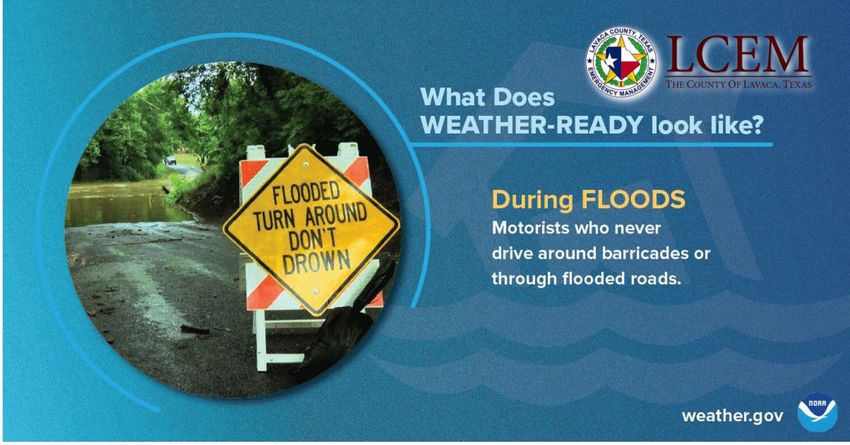
Governor Abbott Renews Border Security
       Disaster Declaration In July 2021
July 30, 2021 | Austin, Texas
WHEREAS, I, Greg Abbott, Governor of Texas, issued a disaster proclamation on May 31,
2021, certifying under Section 418.014 of the Texas Government Code that the surge of
individuals unlawfully crossing the Texas-Mexico border posed an ongoing and imminent
threat of disaster for a number of Texas counties and for all state agencies affected by this
disaster; and

WHEREAS, I amended the aforementioned proclamation on June 25, 2021, including to
modify the list of affected counties and therefore declare a state of disaster for Brewster,
Brooks, Crockett, Culberson, DeWitt, Dimmit, Edwards, Frio, Goliad, Gonzales, Hudspeth, Jeff
Davis, Jim Hogg, Kimble, Kinney, La Salle, Lavaca, Live Oak, Maverick, McMullen, Midland,
Pecos, Presidio, Real, Terrell, Uvalde, Val Verde, and Zapata counties, and for all state
agencies affected by this disaster; and

WHEREAS, on June 30, 2021, I renewed that disaster proclamation, as amended, and also
declared a state of disaster for Colorado, Crane, Galveston, Kenedy, Mason, Medina, and
Throckmorton counties based on the same certified conditions; and

WHEREAS, on July 15, 2021, I amended the proclamation issued on June 30, 2021, to modify
the list of affected counties to also declare a state of disaster for Bee, Jackson, Schleicher,
Sutton, Webb, and Zavala counties based on the same certified conditions; and

WHEREAS, the certified conditions continue to exist and pose an ongoing and imminent
threat of disaster as set forth in the prior proclamations; and
Governor Abbott Renews Border Security
      Disaster Declaration In July 2021
WHEREAS, communications with county officials have confirmed that the certified conditions
now also pose an ongoing and imminent threat of disaster in Menard County;

NOW, THEREFORE, in accordance with the authority vested in me by Section 418.014 of the
Texas Government Code, I do hereby declare a state of disaster for Menard County, and
I do hereby renew the disaster proclamation, as amended and renewed, for Bee, Brewster,
Brooks, Colorado, Crane, Crockett, Culberson, DeWitt, Dimmit, Edwards, Frio, Galveston,
Goliad, Gonzales, Hudspeth, Jackson, Jeff Davis, Jim Hogg, Kenedy, Kimble, Kinney, La Salle,
Lavaca, Live Oak, Mason, Maverick, McMullen, Medina, Midland, Pecos, Presidio, Real,
Schleicher, Sutton, Terrell, Throckmorton, Uvalde, Val Verde, Webb, Zapata, and Zavala
counties, and for all state agencies affected by this disaster. All orders, directions,
suspensions, and authorizations provided in the Proclamation of May 31, 2021, as amended
and renewed on June 25, June 30, and July 15, 2021, are in full force and effect.

In accordance with the statutory requirements, copies of this proclamation shall be filed with
the applicable authorities.

IN TESTIMONY WHEREOF, I have hereunto signed my name and have officially caused the
Seal of State to be affixed at my office in the City of Austin, Texas, this the 30th day of July,
2021.
Governor Greg Abbott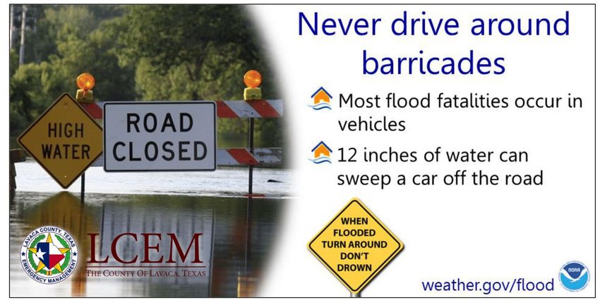
Governor Abbott Issues Executive Order GA-37 Restricting
      Transportation Of Migrants Due To COVID-19

July 28, 2021 | Austin, Texas

Governor Greg Abbott today issued an Executive Order restricting ground transportation of
migrants who pose a risk of carrying COVID-19 into Texas communities. The Executive Order
also directed the Texas Department of Public Safety (DPS) to stop any vehicle upon
reasonable suspicion of such violation and reroute such vehicles back to its point of origin or
a port of entry. DPS also has the authority to impound a vehicle that violates the Executive
Order.

"The dramatic rise in unlawful border crossings has also led to a dramatic rise in COVID-19
cases among unlawful migrants who have made their way into our state, and we must do
more to protect Texans from this virus and reduce the burden on our communities," said
Governor Abbott. "This Executive Order will reduce the risk of COVID-19 exposure in our
communities."

View the Governor's Executive Order.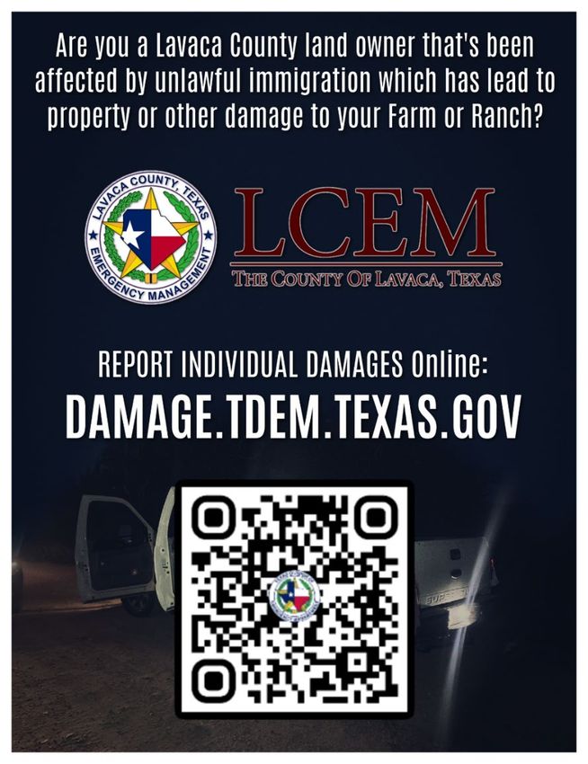
Self Reporting Damage Survey

Lavaca County land owners who have been
affected by the influx of unlawful immigration
are encouraged to complete the state's Self
Reporting Damage Survey to help identify
damages suffered and inform the state's
ongoing efforts to secure the border.

The voluntary survey, available in both English
and Spanish, can be accessed by visiting:

http://damage.tdem.texas.gov.

Reporting damage is a voluntary activity, is not
a substitute for reporting damage to an
insurance agency, and does not guarantee
disaster relief assistance.

Governor Abbott Issues Executive Order Providing
 Clarity And Uniformity In The State's COVID-19 Response

• AUSTIN - Governor Greg Abbott today issued an Executive Order (GA-38)
  combining several existing COVID-19 executive orders to promote statewide
  uniformity and certainty in the state's COVID-19 response.

• “Today’s executive order will provide clarity and uniformity in the Lone Star
  State’s continued fight against COVID-19,” said Governor Abbott. “The new
  Executive Order emphasizes that the path forward relies on personal
  responsibility rather than government mandates. Texans have mastered the
  safe practices that help to prevent and avoid the spread of COVID-19. They
  have the individual right and responsibility to decide for themselves and their
  children whether they will wear masks, open their businesses, and engage in
  leisure activities. Vaccines, which remain in abundant supply, are the most
  effective defense against the virus, and they will always remain voluntary –
  never forced – in the State of Texas.”

• View the Governor’s Executive Order here:

 https://gov.texas.gov/uploads/files/press/EO-GA-
 38_continued_response_to_the_COVID-19_disaster_IMAGE_07-29-
 2021.pdf
Health Advisory: COVID-19 Variants
                July 20, 2021
• Background
• Because viruses constantly change through mutation, new variants of the virus that
  causes COVID-19 are expected to occur. The Centers for Disease Control and
  Prevention (CDC) have identified multiple COVID-19 variants of concern, which may be
  more contagious or cause more severe illness than other
• variants. Current variants of concern are: Alpha (B.1.17), Beta (B.1.351), Delta
  (B.1.617.2), and Gamma (P.1) 1.

• Delta Variant
• The delta variant has been increasing in recent weeks and is now estimated to cause
  over 57% of COVID19 cases in the United States. Cases of COVID-19 caused by the
  delta variant have also been increasing in Texas The delta variant has been shown to
  be more contagious than other variants of COVID-19 and is expected to continue to
  spread rapidly in areas where vaccination rates are low.

 Prevention
• Current scientific evidence suggests that all authorized vaccines work on the variants
  circulating in the United States. COVID-19 vaccines have been shown to be effective at
  preventing illness in those who are fully vaccinated. No vaccines are 100% effective,
  but COVID-19 vaccines have also been shown to be effective at reducing the severity of
  illness in those who get sick after being fully vaccinated. As more variants of COVID-19
  are identified and studied, vaccines remain an important tool in stopping the spread of
  illness in our communities.
Health Advisory: COVID-19 Variants
July 20, 2021
• Variant Surveillance
• Healthcare providers that would like to participate in laboratory surveillance to
identify variants of concern in Region 8 can contact the DSHS Region 8
Epidemiology Team by calling: 210-949-2121 or by emailing:
Region8.Epi@dshs.texas.gov. Specimens that meet criteria will be submitted for
sequencing and variant identification.
• For more information on COVID-19 variants:
• https://www.cdc.gov/coronavirus/2019-ncov/variants/variant-
info.html
• https://covid.cdc.gov/covid-data-tracker/#variant-proportions
• https://www.dshs.texas.gov/news/updates.shtm#variants
• For questions, please contact DSHS Region 8 at: (210) 949-2000 during business
hours or (210) 949- 2121 after-hours.COVID-19 Case Overview
Confirmed Active Recovered Deaths
Total
DSHS PHR 8
Lavaca County
2,057 30 2,470 81
+13 +17 +9 0
Golden
Crescent
17,964 451 18,600 423
Region (TSA-S)
+369 +197 +210 0COVID-19 Case Overview TSA – S (Calhoun, De Witt, Goliad, Jackson, Lavaca, and Victoria Counties) Trauma COVID + COVID + DSHS TSA-S AVAILABLE TOTAL AVAILABLE Service PATIENTS % OF ALL COVID + STAFFED STAFFED STAFFED Area – S PATIENTS HOSPITALIZED BEDS BEDS BEDS Hospital Capacity 08/01/2021 83 22.3% 14.4% 99 472 21% 07/31/2021 84 21.4% 12.2% 80 472 17% 07/30/2021 76 18.6% 11.3% 66 475 14% 07/29/2021 67 17.0% 11.2% 76 469 16% 07/28/2021 60 15.3% 9.7% 71 464 15% 07/27/2021 57 14.1% 8.5% 62 466 13% 07/26/2021 56 15.1% 7.2% 102 474 22%
Lavaca County OEM COVID-19 Response

The Texas Department of State Health Services is beginning to
transition back into normal operations, and weekly COVID-19 County
Reports will be discontinued. Case counts can still be obtained from the
statewide dashboard here.

With COVID-19 vaccines now widely available and new infections and
hospitalizations down significantly, this information no longer provides
the benefit it did during the height of the pandemic.

Additional information on the COVID-19 Response may be obtained on
the Department of State Health Services - Public Health Region 8 -
COVID-19 Website.
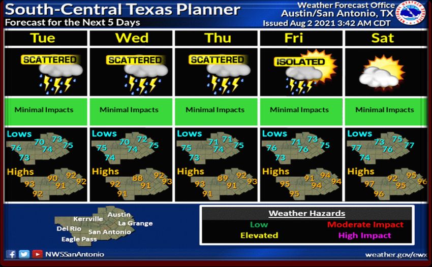
Locally Heavy Rain threat
               will continue through Tuesday

Some active weather has hit
the area over the past 24
hours as a stationary front
hangs over the area. We had
some isolated flash flooding
early this morning with some
impressive rain totals of 4-6
inches. This active pattern
will continue for most of the
week, but highest rain
chances will be the next 36
hours. An isolated flash flood
threat will continue during
that time. Some areas have
yet to see any rain...others
are already saturated....so
just be aware that flooding
could start quickly as the
next round of storms is
already forming in the Hill
Country and West Central
Texas.
Locally Heavy Rain threat
will continue through Tuesday
✓ Scattered showers and storms formed
yesterday, overnight, and again this
morning as a stationary front hangs over
the area.
✓ A few areas the past 24 hours have seen
rain totals exceeding 4-6 inches (near
Spring Branch and Seguin), elsewhere
widespread 0.5-2 inches has occurred over
much of South Central Texas
✓ The locally heavy rain has prompted
some Flood Advisories and Flash Flood
Warnings.
✓ More storms are forecast this afternoon
over the Hill Country, and possibly moving
into the I-35 corridor later today and
tonight, then to the southern counties by
Tue AM.
✓ Storms may produce 1-2 inches of
additional rainfall, with isolated higher
totals.
✓ Rain threat will be highest the next 36
hours, with lesser chances mid-end of the
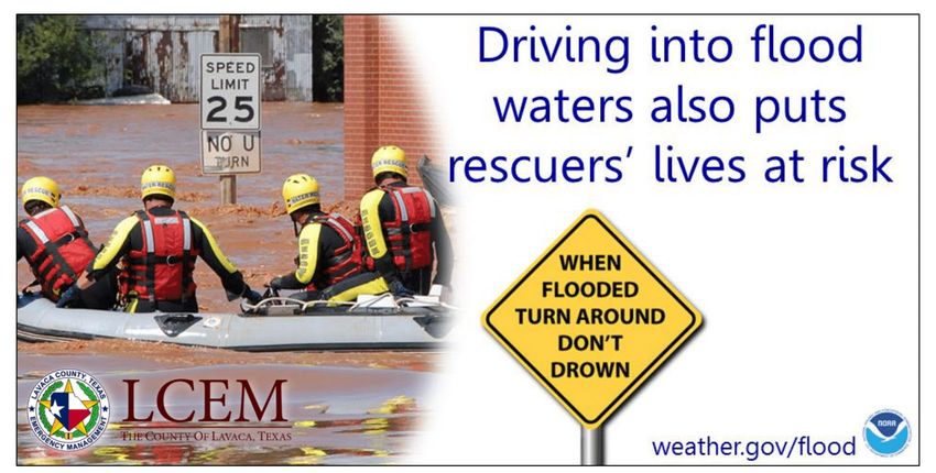
weekSafety Reminders…Turn Around, Don’t Drown
Safety Reminders…Turn Around, Don’t Drown
Safety Reminders
Safety Reminders
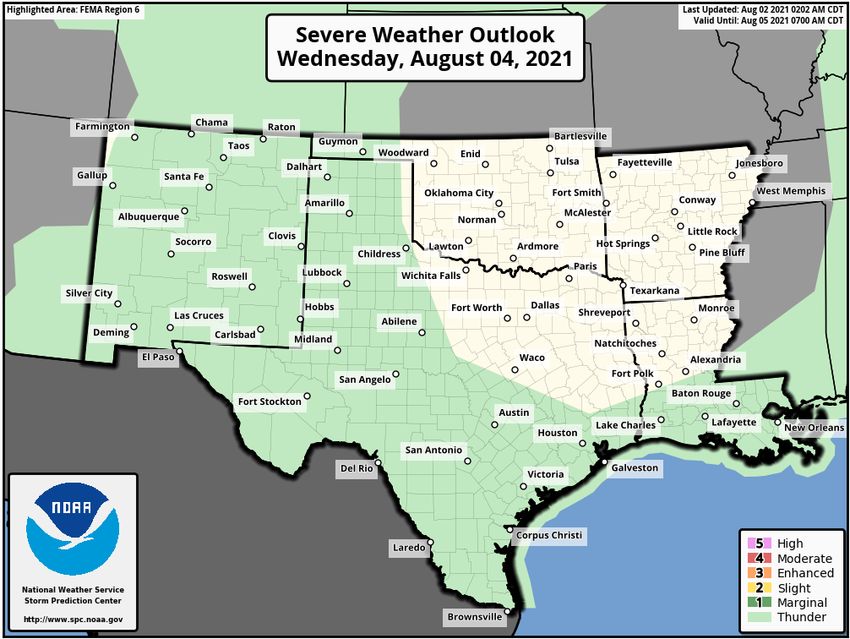
Hazardous Weather Outlook

  This Hazardous Weather Outlook is for South-Central Texas..

  .DAY ONE...Today And Tonight.

  Numerous showers and thunderstorms are expected to continue today
  through tonight. Some storms will move very slowly, resulting in
  an isolated potential of 3 to 4 inch rains. Localized flooding
  will be possible today and tonight. The stronger storms may also
  contain gusty winds of around 40 mph.

  .DAYS TWO THROUGH SEVEN...Tuesday through Sunday.

  Scattered thunderstorms are expected Tuesday and Wednesday.
  Isolated pockets of heavy rainfall will be possible each day.

  .SPOTTER INFORMATION STATEMENT...

  Spotter activation is not anticipated.
Hazardous Weather Outlook
Hazardous Weather Outlook
Hazardous Weather Outlook
Lavaca County Planner

With a frontal boundary hanging around rain chances will continue to be elevated through Thursday. The daily rain
chances should lead to milder daytime temperatures for much of the work week. By Friday, high pressure will
begin to build back over Texas leading to decreasing rain chances and increasing temperatures.
Lavaca County Weather

Tonight: Mostly cloudy with a chance of showers and thunderstorms. Lows in the mid 70s. Northwest winds 5 mph. Chance of rain
50 percent.

Tuesday: Mostly cloudy with a chance of showers and thunderstorms. Highs in the lower 90s. North winds 5 to 10 mph. Chance of
rain 50 percent.

Tuesday Night: Partly cloudy with a slight chance of showers and thunderstorms. Lows in the mid 70s. Northeast winds 5 to 10
mph. Chance of rain 20 percent.

Wednesday: Partly cloudy with a slight chance of thunderstorms. A slight chance of showers in the morning, then a chance of
showers in the afternoon. Highs in the lower 90s. Northeast winds 5 to 10 mph. Chance of rain 40 percent.

Wednesday Night: Partly cloudy. A slight chance of showers after midnight. Lows in the mid 70s. East winds 5 to 10 mph. Chance of
rain 20 percent.

Thursday: Partly cloudy. A slight chance of showers in the morning, then a chance of showers and thunderstorms in the afternoon.
Highs in the mid 90s. Chance of rain 40 percent.

Thursday Night: Partly cloudy. A slight chance of showers and thunderstorms after midnight. Lows in the mid 70s. Chance of rain 20
percent.

Friday: Partly cloudy. A slight chance of showers and thunderstorms in the morning, then a chance of showers and thunderstorms in
the afternoon. Highs in the mid 90s. Chance of rain 50 percent. Highest heat index readings up to 105 in the afternoon.

Friday Night: Mostly clear. Lows in the mid 70s.

Saturday: Sunny. A slight chance of showers and thunderstorms in the afternoon. Highs in the mid 90s. Chance of rain 20 percent.
Highest heat index readings up to 105 in the afternoon.

Saturday Night: Clear. Lows in the upper 70s.
Tropical Weather Awareness
Monitoring the Tropics - Discussion

ropical Weather Outlook
NWS National Hurricane Center Miami FL
200 PM EDT Mon Aug 2 2021

For the North Atlantic...Caribbean Sea and the Gulf of Mexico:

1. A surface trough of low pressure over the far eastern Atlantic Ocean
centered a few hundred miles south of the Cabo Verde Islands is
producing disorganized showers and thunderstorms. Some development
of this system is possible during the next couple of days while it
moves northward or northwestward before the system moves over cool
waters by Thursday.
* Formation chance through 48 hours...low...10 percent.
* Formation chance through 5 days...low...20 percent.

Forecaster Blake
KEETCH-BYRAM DROUGHT INDEX

  KBDI    Min   Max   Average   Change
Summary

LAVACA    206   393    325      +17
Lavaca County Fire Danger

   Lavaca County Fire
     Danger Level:

       LOW (GREEN)

When the fire danger is low
 it means that fuels do not
   ignite easily from small
embers, but a more intense
     heat source, such as
lightning, may start fires in
  duff or dry, rotten wood.
Lavaca County Fire Weather
A generally wet pattern will continue over much of South Central Texas today and tomorrow as a weakness in the
upper level ridge and a boundary draped across the area act to focus chances for isolated showers and
thunderstorms. Some of these could drop locally heavy rainfall. By Wednesday the upper level ridge tries to start
building back over Texas, but at least slight rain chances continue in the forecast for Wednesday and Thursday. By
Friday and into the weekend, drier weather prevails allowing temperatures to warm again. Relative humidity values
should remain above 35 percent through the period.
Karnes-De Witt-Lavaca-
Including the cities of Karnes City, Cuero, and Hallettsville
154 PM CDT Mon Aug 2 2021
Today Tonight Tue
Cloud cover Pcldy Mcldy Pcldy
Chance precip (%) 40 50 50
Precip Type Tstms Tstms Tstms
Temp (24h trend) 92 (-4) 74 (-3) 91
RH % (24h trend) 49 (+5) 87 (-13) 54
20ftWnd-AM(MPH) W 13 NW 6
20ftWnd-PM(MPH) NW 9 N 6 N 8
Mixing hgt(ft-AGL) 3552 4301
Transport wnd (MPH) NW 6 N 9
CWR 10 30 30
LAL 3 4 4
Haines Index 4 3 3
Remarks...None.Lavaca County Air Quality Index Forecast Region (Click name for AIRNOW Mon Tue Wed Thu version) 08/02/2021 08/03/2021 08/04/2021 08/05/2021 Victoria Good Good Good Good This forecast was last updated at 1:50 PM on Monday, August 2nd, and is updated daily on normal TCEQ work days and may also be updated on weekends or holidays when air pollution levels are high. Regardless of our forecast, we always recommend that each individual determine what level of activity they should conduct based on the actual local conditions.
Drought Monitor Austin – San Antonio WFO
Texas A&M Agrilife Crop & Weather Report

COASTAL BEND -

Crop conditions continued to deteriorate under more rain. Some fields were still
holding water. Sorghum heads were sprouting. Sugarcane aphid populations were
increasing in grain sorghum. Corn was mature and needed harvesting, but field
conditions were too wet. Cotton was shedding bolls due to excess moisture.
Rainfall during rice pollination was estimated to reduce rice yields 5%-10%.
Pastures were lush and should produce heavy hay yields as soon as conditions dry
enough. Armyworms were spotted in fields and pastures. Cattle remained in good
to excellent condition with all the grazing, and market prices were on the rise.
Lavaca County Road Closures
*This is a partial list of reported road/street closures as reported by State, County, and
                         Local Municipalities, to Lavaca County OEM.

Lavaca County:

• Lavaca County Road 423
• Lavaca County Road 462
• Lavaca County Road 395 from LCR 392 to culvert replacement site.
Lavaca County Cone Zone • YOAKUM – Texas Department of Transportation will start a road rehabilitation project on Monday, August 2, 2021 and resurfacing project on August 7, 2021. On Monday, August 2nd the contractor will begin the road rehabilitation project on SH 111 from US 77A to US 77. The existing pavement surface will be removed and replaced with new asphalt material. Work will be done in 2 block sections at a time to lower traffic interference. Work will be performed during daylight hours with alternating one-way traffic closures. PARKING ALONG THIS ROUTE WILL NOT BE ALLOWED DUE TO THE OPERATIONS. Work is scheduled to be completed by August 31st - weather permitting. • On Saturday, August 7th the contractor will begin the resurfacing project on US 77A from SH 111 to SH 95. We will be removing and replacing the surface layer. This operation will require alternating lane closures and one-way traffic control setups. Work will be performed during daylight hours only. Work is scheduled to be completed by August 31st - weather permitting. • Hunter Industries Ltd, of San Marcos, Texas, was awarded the contract as part of a larger project that was awarded for $2.7 million dollars. • We are asking drivers to watch for flaggers, slowed traffic, and construction equipment and employees entering and exiting the work zone. Motorists should expect possible traffic delays, are urged to use caution when driving through the work zone, and should keep the following tips in mind: • • Slow down and always follow posted work zone speed limits. Speeding is one of the major causes of work zone crashes. Remember, traffic fines double in work zones. • • Pay attention. Workers and heavy equipment may only be a few feet from passing vehicles. • • Be patient. Delays from roadway construction can be frustrating, but it only takes a few extra minutes to slow down for a work zone.
Lavaca County Cone Zone

US 77A from SH 111 to SH 95     SH 111 from US 77A to US 77
Lavaca County Significant Events

             DATE(S)                LOCATION                  EVENT
08/19/2021             08/19/2021   HALLETTSVILLE      LOUISE VS SACRED HEART
08/27/2021             08/27/2021   HALLETTSVILLE      SHINER VS HALLETTSVILLE

08/27/2021             08/27/2021      SHINER         YORKTOWN VS SAINT PAUL

09/03/2021             09/03/2021      SHINER            BLANCO VS SHINER
09/03/2021             09/03/2021   HALLETTSVILLE   ROSEHILL CHRISTIAN VS SACRED
                                                                HEART
09/03/2021             09/03/2021     YOAKUM           SMITHVILLE VS YOAKUM
09/04/2021             09/05/2021      SHINER        Shiner Catholic Church Picnic

09/05/2021             09/05/2021   HALLETTSVILLE         Sacred Heart Picnic
09/10/2021             09/10/2021      SHINER          SA DAVENPORT VS SHINER

09/10/2021             09/10/2021   HALLETTSVILLE     GANADO VS HALLETTSVILLE

09/17/2021             09/17/2021      SHINER             TBD VS SAINT PAUL
09/17/2021             09/17/2021     YOAKUM            NEEDVILLE VS YOAKUM
09/18/2021             09/18/2021     YOAKUM                 DOWNTOWN
                                                            STREET DANCE
09/24/2021             09/24/2021      SHINER            BURTON VS SHINER
09/24/2021             09/24/2021   HALLETTSVILLE   SCHULENBURG VS HALLETTSVILLE

09/25/2021             09/25/2021   HALLETTSVILLE          HALLETTSVILLE
                                                           KOLACHE FEST
***DUE TO A SCHEDULING CONFLICT, THE
DATE FOR THIS TRAINING HAS BEEN
CHANGED***
Lavaca County OEM has secured training from
TRANSCAER, and Union Pacific Railroad, and
will be bringing the RAILROAD 101 class to the
Yoakum Fire Station, 203 Nelson Street,
Yoakum, Texas 77995 one August 17, 2021
from 6 until 10 PM.
The program will provide information about
railroad operations, hazards and safety rules,
Rail Hazmat safety, and emergency response
procedures. Refreshments, copies of training
materials, & certificate of completion will be
provided after the event.
Please RSVP with Lavaca OEM by 5:00PM
on 8/5/2021Paradigm Training Center • Below is a link to the Paradigm online training center. The online content is 100% free. There is a Contractor & Excavator Pipeline Safety course and a Coordinated Response Exercise available as well as links to all reference material and tools used in the presentations. Each course is less than 30 minutes in length and contain narrated videos. If interested, people would need to register for an account and can use Marathon Oil as the representing company. • https://www.pdigm.com/Training_Center.html • I encourage all emergency responders to check out the courses and the linked tools. They can all be very useful. Linked materials do not only include Marathon information, but other operators in the area that also use Paradigm.
End of Situation Awareness Brief

Honorable Mark Myers - Emergency Management Director

  Egon Barthels - Emergency Management Coordinator

     109 N La Grange | P.O. BOX 243 | Hallettsville, TX 77964-0243
ph. 361.798.5628 | email: eoc@co.lavaca.tx.us | website: LavacaOEM.com
You can also read