Impacts of Disasters and Disasters Risk Management in Malaysia: The Case of Floods - Economic Research Institute for ASEAN ...
←
→
Page content transcription
If your browser does not render page correctly, please read the page content below
Chapter         14
Impacts of Disasters and Disasters Risk
Management in Malaysia: The Case of
Floods

Ngai Weng Chan
Universiti Sains Malaysia, Penang, Malaysia

December 2012

This chapter should be cited as
Chan, N. W. (2012), ‘Impacts of Disasters and Disasters Risk Management in Malaysia:
The Case of Floods’, in Sawada, Y. and S. Oum (eds.), Economic and Welfare Impacts
of Disasters in East Asia and Policy Responses. ERIA Research Project Report 2011-8,
Jakarta: ERIA. pp.503-551.
CHAPTER 14
Impacts of Disasters and Disaster Risk Management in
Malaysia: The Case of Floods
NGAI WENG CHAN*
Universiti Sains Malaysia
Malaysia lies in a geographically stable region, relatively free from natural disasters, but is affected by
flooding, landslides, haze and other man-made disasters. Annually, flood disasters account for significant
losses, both tangible and intangible. Disaster management in Malaysia is traditionally almost entirely based
on a government-centric top-down approach. The National Security Council (NSC), under the Prime
Minister’s Office, is responsible for policies and the National Disaster Management and Relief Committee
(NDMRC) is responsible for coordinating all relief operations before, during and after a disaster. The
NDMRC has equivalent organizations at the state, district and “mukim” (sub-district) levels. In terms of
floods, the NDMRC would take the form of the National Flood Disaster Relief and Preparedness Committee
(NFDRPC). Its main task is to ensure that assistance and aid are provided to flood victims in an orderly and
effective manner from the national level downwards. Its approach is largely reactive to flood disasters. The
NFDRPC is activated via a National Flood Disaster Management Mechanism (NFDMM). Members of the
NFDRPC include Government departments/agencies and social organizations which provide shelter, rescue
and food supplies in case of disaster. The NFDRPC meets at least once a year, normally before the onset of
the northeast monsoon. The meeting is between all organizations involved with flood disaster management,
and is focused on the need to get ready before the monsoon arrives (bringing floods with it). Its purpose is to
ensure that its machinery will run smoothly. At the national level, the NSC is the secretariat for the NFDRPC
which comprises members from the Ministries of Information, Finance, National Unity and Social
development, Transport, the Federal Chief Secretary, the Federal Police Department and the Federal Armed
Forces. The NFDRPC coordinates all relief operations from the Malaysian Control Centre in Kuala Lumpur.
The NFDMM is basically a mechanism responding to disasters, as its name suggests. As such, its approach
towards disaster management/reduction is largely reactive. Because Malaysia’s main risk is flooding, the
NFDMM is largely targeted towards handling monsoon flooding. Consequently, this mechanism is less than
effective and should be re-modeled into something more pro-active. In terms of flood management, the
Drainage and Irrigation Department (DID) is the responsible agency. However, being an engineering-based
organization, DID’s approach is largely focused on structural measures in controlling floods. It needs to
embrace a more holistic approach towards flood management via a multi-disciplinary effort. Non-structural
measures are easy to implement, less expensive and community-friendly, and need to be employed more widely.
There is also a need for greater stakeholders participation, especially from NGOs at all levels in the disaster
cycle. Capacity building for NGOs, local communities and disaster victims is also necessary. The disaster
management mechanism should also adopt more non-structural measures, bring in state-of-the-art technology
and cooperate internationally with other countries for addressing transboundary disasters. However, the
politicization and mediatization of disasters should be controlled while disaster insurance should be introduced
and disaster legislation strengthened.
Keywords: Disaster Risk Management, Flood Management, Malaysia, Flood Damage, Politicization of Disaster
The author is indebted to Universiti Sains Malaysia for funding provided in the “Research University (RU) Grant”
1001/PHUMANITI/816106 titled “The Significance of Human factors in Effective Disaster Management in
Malaysia: A Case Study of Flood Disasters” and to the Economic Research Institute for ASEAN and East Asia
(ERIA)for funding the project “Economic and Welfare Impacts of Disasters in East Asia and Policy Responses”
which led to the publication of this chapter.
* The author would like to thank ERIA for funding the writing of this chapter under the ERIA Research Project
FY2011. It is also acknowledged that the data and research on flood management was funded by Universiti Sains
Malaysia under the Research University (RU) Grant 1001/PHUMANITI/816106 and FRGS Grant
203/PHUMANITI/6711198.
503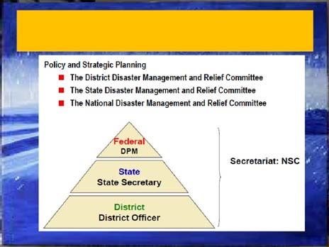
1. Introduction

    This chapter opens with a general discussion on the background and history of
disaster occurrence and risk management in Malaysia. As floods are the single most
severe of all disasters in Malaysia, the chapter specifically focuses on flood disaster
management. This is followed by an emphasis on ex post and ex ante analysis of the
past and potential socioeconomic impacts of flood disasters in Malaysia. It then reviews
and assesses the effectiveness of Malaysia’s flood disaster management system with
respect to “Risk Identification, Emergency Preparedness, Institutional Capacity
Building, Risk Mitigation, and Catastrophe Risk Financing”. A detailed discussion on
the current constraints that prevent people from engaging in post-disaster supports
follows. Finally, the chapter ends with policy recommendations for reforms at the
national level and explores the prospects for regional cooperation framework in disaster
management.

1.1.Overview of Disasters in Malaysia

    Malaysia lies in a geologically stable region which is free from earthquakes,
volcanic activities, and strong winds such as tropical cyclones which periodically affect
some of its neighbors. It lies geographically just outside the “Pacific Ring of Fire”.
Hence, it is free from volcanic eruptions and earthquakes. It also lies too far south of
the major typhoon paths, although tail-ends of tropical storms have occasionally hit it.
However, that does not mean Malaysia is totally “Free” from natural disasters and
calamities, as it is often hit by floods, droughts, landslides, haze, tsunamis, and human-
made disasters (Parker, et al. 1997). Annually, disasters such as floods account for a
significant number of casualties, disease epidemics, property and crop damage and other
intangible losses (Chan, et al. 2002a).
    In the past few decades, the country has experienced various extreme weather and
climatic events, including El Nino in 1997 (which led to severe droughts), La Nina in
2011 and 2012 (which brought floods), freak thunderstorms almost every year (which
brought wind damage, flash floods and landslides), monsoonal floods (which brought

                                           504
about heavy losses, including loss of life in many parts of the country exposed to
monsoon winds), and haze (which brought about poor air quality, extreme heat and
drought). Monsoonal floods are an annual occurrence which varies in terms of severity,
place and time of occurrences with a recent 2010 flood in Kedah and Perlis being
among the worst flood ever experienced by the country. The total economic loss and
the financial burden on the government were enormous. When two or more of these
events coincide such as the “Terrible twins” (La Nina and the monsoon season) that hit
the federal capital of Kuala Lumpur and Selangor in December 2011, the damage is
compounded (The Star, 2011). The haze phenomenon in 1997/98 also caused
significant problems due to losses in tourist income, health effects and hospitalization
costs, and mitigation losses (Kunii, et al. 2002) More recently, the 2005 haze episode in
Malaysia was a week-long choking haze (at its worst on August 11) that affected mostly
the central part of Peninsular Malaysia. The air quality in Kuala Lumpur was so poor
that health officials advised citizens to stay at home. A state of emergency was declared
in Port Klang and Kuala Selangor. The event also led to crisis talks with Indonesia and
caused widespread health effects and inconvenience (Ahmad and Hashim, 2006). The
Asian Tsunami which hit in December 2004 was also very severely felt on the coasts of
Peninsular Malaysia, most notably in Penang, Kedah, Perlis and Langkawi (Chan,
2009). Due to Malaysia’s wet equatorial climate regime with frequent heavy rain
storms of high rainfall intensities, landslide disasters are common. In recent decades,
landslide disasters in the Klang Valley Region and elsewhere have caused significant
loss of life, property and infrastructure damage, environmental destruction and anxiety
(Chan, 1998a; Periasamy, 2011). In addition, the country is also regularly hit by man-
made disasters such as fires, accidents and the collapse of structures and buildings,
which cause considerable damage to property and loss of life (Hussin, 2005).
In terms of human-made and human-enhanced disasters, Abdul Malek (2005) listed
the following major disasters: fire and explosions at the Bright Sparklers factory in
Sungai Buloh in 1991 which claimed 22 lives; fire and explosions at South Port Klang
in 1992 which claimed 10 lives; collapse of the Highland Towers apartment blocks in
Hulu Kelang in 1993 which claimed 48 lives; massive landslide at the Genting
Highlands in 1995 which claimed 20 lives; mudslides in Pos Dipang, Perak, on 29
August 1996 which claimed 44 lives; severe haze episodes in 1997 and 1998 which
505caused loss in tourist revenues in the millions of dollars and hospitalized thousands of
people; landslide at Sandakan, Sabah, in February 1999 due to heavy downpour which
claimed 17 lives; luxury home collapsed on 21 November 2002 in the Ulu Kelang area
killing eight people.
Arguably, of all the disasters in Malaysia, floods are most frequent and bring the
greatest damage annually. Floods are therefore considered as the most severe type of
disaster experienced in Malaysia. Historically, there have been big flood events in 1886,
1926, 1931, 1947, 1954, 1957, 1965, 1967, 1970/1971, 1988, 1993, 1996, 2000,
2006/2007, 2008, 2009, and 2010. Of these floods, the 1926 flood was known as “The
storm forest flood” because it destroyed hundreds of square kilometers of lowland forest
on the floodplains of the Kelantan and Besut rivers. Records show that the flood was
accompanied by gale force winds (Drainage and Irrigation Department, Undated).
According to the Drainage and Irrigation Department (DID), this flood was considered
“the biggest flood in living memory” in Malaysia as it affected almost the entire length
and breadth of Peninsula Malaysia, causing extensive damage. In 1996, floods brought
by Tropical Storm Greg in Keningau (Sabah State), claimed 241 lives, caused more than
USD 97.8 million damage to infrastructure and property and destroyed thousands of
houses. In 2000, floods caused by heavy rains killed 15 people in Kelantan and
Terengganu, and caused more than 10,000 people to flee their homes in northern
Peninsular Malaysia. The December 2006/January 2007 floods in Johor caused 18
deaths and USD 489 million in damage. In 2008, floods occurred in Johor again, killing
28 people and causing damage estimated at USD 21.19 million. In 2010, the floods
affected transportation in and around Kedah and Perlis, shutting down rail, closing roads
including the North-South Expressway (The Star, 2010c) and the airport in Kedah’s
capital city of Alor Setar leaving helicopters as the only mode of aerial transport into
Kedah and Perlis (The Star, 2010d). Water supply in Kedah and Perlis was
contaminated, forcing these two states to seek supplies from their neighbor Perak
(Bernama, 5 November 2010a). Kedah and Perlis are the “Rice Bowl” of Malaysia, and
the floods destroyed an estimated 45,000 hectares of rice fields with the government
pledging USD8.476 million in aid to farmers (in both states (Bernama, 2010c). The
floods killed four people, with more than 50,000 evacuated. In Perlis, the floods
506submerged over two-thirds of the state's land. Table 1 gives a list of some of the major
disasters that have occurred in Malaysia.
1.2. Literature Review
The literature review on disaster management in Malaysia is largely based on a
review of government reports from disaster management agencies such as the National
Security Council (NSC), the Public Works Department (PWD), the Drainage and
Irrigation Department (DID), the Welfare Department (WD), the Statistics Department
(SD), State Governments, the Malaysian Medical Relief Society (MERCY), Red
Crescent Society (RCS), Red Cross Society (RCS) and other NGOs, and other
agencies/organizations. The literature review also covers research reports, academic
theses, journal papers, newspaper reports and websites of reputed organizations.
1.2.1. The Top-down Government-centric Model
Historically, disaster management in Malaysia has commonly been considered as a
government function and is largely based on top-down government-centered machinery
(Chan, 1995). At the very top, the Government Agency responsible for disaster
management (all sorts) is the National Security Division (NSD) under the Prime
Minister’s Department. The NSD is therefore responsible for coordinating activities
related to the preparation for, prevention of, response to and handling of disasters,
basically referring to natural and technological disasters. The NSD is bound by the
National Security Council (NSC) Directive No. 20 on "Policy and Mechanism on
National Disaster and Relief Management", issued on 11th May 1997. The NSC
Directive No. 20 is an Executive Order from the Prime Minister aimed at outlining
policy on disaster and relief management according to the level and complexity of
disaster. The directive is also aimed at establishing a management mechanism whereby
the roles and responsibilities of the various agencies involved in handling disasters are
outlined/identified. Currently, the handling and resolving of disasters in Malaysia are
managed via the Committee System which emphasizes the concept of coordination and
mobilization of agencies involved, in an integrated and coordinated manner. At the
507highest Federal level, the National Disaster Management and Relief Committee
(NDMRC) is in charge of managing and handling national-level disasters. Lower down
the scale, state-level disasters are managed by the State Disaster Management and
Relief Committee (SDMRC). At the third level, district-level disasters are managed by
at the District Disaster Management and Relief Committee (DDMRC). At the lowest
village level, village-level disasters are managed by the DDMRC with inputs from the
village committee (though there is, strictly speaking, no official disaster management
and relief committee at the village level).
Table 1: Disaster Incidents in Malaysia
Property,
Natural, Human- Number
Material, Crop
Date/Year Incident made or of
or Other Losses
Combination Deaths
(USD)
1926 Flood known as “The Natural Thousands of NA
storm forest flood” hectares of forests
destroyed
19 October 1968 Collapse of Four-Story Human-made NA NA
Building – The Raja Laut
Tragedy
1988 Sultan Abdul Halim Ferry Human-made Injured 1,634 32
Terminal–Royal Inquiry people
1991 Bright Sparklers- Human-made Millions 22
1991(Royal Inquiry)
21 June 1992 Choon Hong III oil tanker Human-made NA 13
explodes and burns (Royal
Inquiry)
1992 Fire and explosions at Human-made Millions 10
South Port Klang
December 1993 Collapse of Human-made Tens of Millions 48
Highland Towers
apartments
June 1993 Genting Highlands Combination Millions 20
Landslide
29 August 1996 Pos Dipang landslide- Combination NA 44
mudslide
508Property,
Natural, Human- Number
Material, Crop
Date/Year Incident made or of
or Other Losses
Combination Deaths
(USD)
December 1996 Floods brought by Combination 300 million 241
Tropical Storm Greg in
Keningau (Sabah State)
1997 El Nino in 1997 which led Combination Millions in lost NA
to severe droughts, forest tourist revenue,
fires & haze health costs &
business losses
June 1999 Japanese Encephalitis Combination Millions 60
Virus Outbreak
February 1999 Landslide at Sandakan, Combination Millions 17
Sabah
2000 Floods caused by heavy Combination Millions 15
rains in Kelantan and
Terengganu
December 2004 Asian Tsunami Natural Millions 68
November 2002 A luxury home collapsed Combination Millions 8
in Ulu Kelang area
November 2002- Severe Acute Respiratory Combination Millions NA
May 2003 Syndrome (SARS)
2003-2007 Avian Influenza 2003 - Combination Millions NA
2007
2005 Haze Combination NA NA
December 2006 & Floods in Johor State Combination 489 million 18
January 2007
2008 Floods in Johor State 21.19 Million 28
2010 Floods in Kedah and Combination 8.48 Million (Aid 4
Perlis alone)
2011 & 2012 La Nina in 2011 and 2012 Natural NA NA
(which brought floods)
All these committees at various levels are integrated via “Vertical Coordination” (e.g.
between FDMRC and SDMRC) as well as via “Horizontal Coordination” (e.g. between
the State Police Department and the State Drainage & irrigation Department). Through
NSC Directive No. 20, the Government hopes that the handling and resolving of
disasters could be carried out in a more coordinated manner with the integrated
involvement and mobilization of related agencies. All these will in turn ensure that
suffering and losses as a result of disasters can be minimized.
The above disaster management mechanism has been widely applied in flood
disasters which is the major type of disaster affecting the country (Chan, 2011). Before
the country went through modernization and industrialization, there were also
509meteorological disasters, strong winds, rain-induced monsoon floods, and other natural
disasters. However, since independence in 1957, other kinds of disaster have been
experienced, such as fires, explosions, structural collapse, landslides, biological/disease-
related disasters, flash floods and landslides caused by slope disturbance resulting from
human activities. According to Yusof (n.d.), Malaysia has transformed radically from an
agrarian economy to a modern industrialized nation. This rapid process of development
and transformation has given rise to the occurrence of a range of man-made disasters
that are considered as “landmark” disasters whereby various safety and emergency acts
and regulations were proposed, amended or formulated, resulting also in the formation
of specialized teams in disaster management. This government-centric approach is
employed to address both the physical/natural (Sham, 1973) as well as the human
aspects of flood management (Leigh and Low, 1983). In Malaysia, the National
Security Council (NSC) defines a disaster under NSC D20 (National Security Council
Malaysia, 1997) as “An incident that occurs in a sudden manner, complex in nature,
resulting in the loss of lives, damages to property or the environment as well as
affecting the daily activities of local community. Such incident requires the handling of
resources, equipment, frequency and extensive manpower from various agencies as well
as effective coordination and the possibility of demanding complex actions over a long
period of time.” The types of disaster defined under NSC D-20 are classified as
follows: (1) Natural disasters such as floods and landslide; (2) Industrial and
technological disasters; (3) Accidents involving dangerous or hazardous materials (4)
Collapse of high rise buildings and special structures (5) Aviation accidents in public
areas; (6) Railway accidents; (7) Major fire incidents; (8) Collapse of hydroelectric
dams or reservoirs; (9) Nuclear and radiological accidents; (10) Release of poisonous
and toxic gases in public places; and (11) Air and environmental disasters such as haze.
In recent years, Aini, et al. (2001) have discussed the evolution of emergency
management in Malaysia with the authorities trying to keep up with the rest of the
world.
1.2.2. The Technocentric Model
In terms of flood disasters, which are, as previously stated, the major type of
disaster affecting Malaysia, much of the relevant research literature reflects a
510technocentric approach which strongly emphasizes the use of structural/engineering
methods in addressing floods (Chan, 1995). Consequently, it is not surprising to find
that the bulk of the literature on flood studies in Malaysia is largely focused on the field
of engineering and hydrology. Some notable examples are Volker (1971), Drainage and
Irrigation Department (1973, 1974, 1976), Japan International Cooperation Agency
(1989, 1991), Syed Mohammad, et al. (1988), Julien et al. (2010) and Ab. Ghani, et al.
(2012). Such an approach is central within the “Society over Nature” school of thought,
or technocentricism, which asserts that science can solve all flood problems. This
cannot be further from the truth in an ever-changing world, especially in the context of
rapidly developing Malaysia. Despite the fact that technology plays an important role in
flood hazard management, it is a fallacy that it can provide the means of total protection
against all floods. In fact, Jones (1991) has observed that technology can increase
vulnerability to floods.
1.2.3. The Natural Science Perspective
Against the background of the technocentric approach is the “natural science
perspective”, which is essentially the natural scientist's explanation to the occurrence of
flood hazards. Alexander (1993) states that this approach focuses on how natural
processes in the “Earth-Atmosphere System” create hazards. This approach also takes
into account the importance of society in altering the physical processes, but the flood
hazard is principally attributed to the natural causes (e.g. monsoon winds and rains). As
such, it is of paramount importance to monitor and understand the natural processes. It
is also important for the natural scientist to measure and monitor these processes in
order to classify them. The natural processes can also be modified by humans and this
makes them more complicated and difficult to study. Natural scientists often believe
that natural processes can be controlled by technological solutions, which is similar to
the technocentric approach. This perspective is strongly advocated by natural and
physical scientists who employ the hard sciences (e.g. geology, geomorphology,
hydrology and engineering) to flood hazard management. Some good examples of the
natural scientist's approach to flood hazards in Malaysia are Chan (1998b) and Lim
(1988). The natural science perspective is essentially a “tech-fix” approach, although in
recent years it has incorporated ecological, biological, environmental and sustainability
511considerations. Because of its emphasis on technology as a means of alleviating
hazards, it has often been criticized as being too narrow an approach. No field of
science can predict the occurrence of hazard events with any level of certainty.
Furthermore, artificial structures with high protection levels may still be “over-topped”
by an extreme event. For example, the 100-year flood protection structures in the
Federal capital of Kuala Lumpur were over-topped by a more than 1:100 year event in
1971, causing widespread flooding that lasted for weeks. Furthermore, the environment
is ever-changing in the context of a rapidly developing Malaysia. Studies by others
have also shown that disasters occur because of other factors such as the misapplication
of technology, institutional ineffectiveness, warning ineffectiveness, and hazard
generating socio-political systems (Winchester, 1992).
1.2.4. The Organizational Perspective
Another flood disaster management approach is that of the organizational
perspective, originally an approach used by organizational analysts in explaining
hazards. This approach focuses upon the ways in which organizations such as
government agencies, private companies, NGOs and other civil society voluntary bodies
tackle hazards. Disaster managers in the field of economics, geography, systems
analysis, planning and sociology who are concerned with “collective behavior” and
“collective decision-making” are probably responsible for this perspective (Parker,
1992). The role played by organizations cannot be underestimated because they are
powerful and influential. The argument is that organizations may contribute in one way
or another to the creation or worsening of hazards. Turner (1978) examined hazards
arising out of organizational inefficiencies. Reasons for failures include organization
inefficiencies (within and outside), existence of organizational “sub-cultures” which
lead to “collective blindness” to the hazard, “organizational exclusivity”, poor
information dissemination and others. Handmer and Parker (1991) have documented
the tendency for organizations to “groupthink”, resulting in the narrowing of options,
and noted the existence of a high level of secrecy amongst the bureaucracy of
government organizations, all of which hinder emergency planning. In Malaysia, the
organizational approach has been studied by Chan (1997a), who found that
512organizations tend to protect and safeguard self-interest rather than expose their
weaknesses.
1.2.5. The Vulnerability Model and the Structural Paradigm
Vulnerability to flood disasters in Malaysia is another approach (Chan, 2000). The
study of disaster vulnerability originated from the “Structural Paradigm” in which
disasters were believed to be subject to cultural, social, economic and political forces
(Torry, 1979). In developing countries and poor countries, it was discovered that
broader structural forces (local and national) were more powerful and pervasive than
local factors in affecting the outcome of hazards and disasters (Wadell, 1983; Hewitt,
1983). This radical view gave a new insight that went beyond the conventional
geophysical cause of hazards and disasters. More recently, the recognition that
structural forces at the international level can strongly affect local vulnerability has
resulted in an expanded version of the structural paradigm, known as the “political
economy paradigm” or the “political ecology perspective of hazards” (Blaikie, et al.,
1994; Varley, 1994). All these approaches to disasters are essentially a “structuralist”
view that links social relations to disasters and is rooted in Marxist political economy.
Although basically a social/structuralist perspective of hazards emphasizing
vulnerability and lack of access to resources, Blaikie, et al. (1994) avoided using a
purely deterministic approach rooted in political-economy, notions of equating
vulnerability with poverty or some other specific conditions, and definitions of
vulnerability that focus exclusively on the ability of a system to cope with risk or loss.
They advanced the political economy perspective by explaining vulnerability as a
progression from “root causes” to “dynamic pressures” and “unsafe conditions”, that
coincide with hazards, leading to disasters. In Malaysia, Chan (2000) has used this
paradigm to study flood hazards, and has proposed measures to reduce the exposure of
people to flood hazards and also to reduce people’s vulnerability to floods. Chan (1996)
has found that vulnerability to flood disasters in Malaysia is not solely influenced by
poverty, but more importantly by awareness, perception, attitude, experience, length of
residence and social relations (Jamaluddin, 1985).
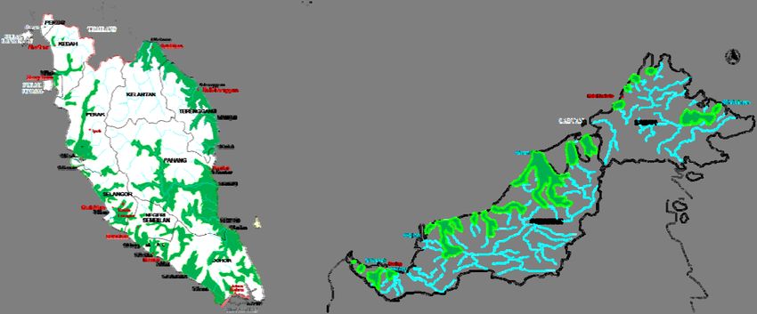
5132. Flood Disaster Risk in Malaysia
Malaysia is a country very prone to flood risks, mostly by nature of its physical (e.g.
topography and drainage) as well as its human geography (e.g. settlement and land use
patterns). The combination of natural and human factors has produced different types
of floods, viz. monsoon, flash and tidal (Chan, 1998b). Malaysians are historically a
riverine people, as early settlements grew on the banks of the major rivers in the
peninsula. Coupled with natural factors such as heavy monsoon rainfall, intense
convection rain storms, poor drainage and other local factors, floods have become a
common feature in the lives of a significant number of Malaysians. Monsoon and flash
floods are the most severe climate-related natural disasters in Malaysia, with a flood-
prone area of about 29,000 km2 affecting more than 4.82 million people (22% of the
population) and inflicting annual damage of USD 298.29 million (Asian Disaster
Reduction Centre (2005) Mitigation and Management of Flood Disasters in Malaysia.
Kobe: Asian Disaster Reduction Centre
http://www.adrc.asia/publications/TDRM2005/TDRM_Good_Practices/PDF/PDF-
005e/Chapter3_3.3.6.pdf accessed May 14 2012) (Figure 1). With annual heavy
monsoon rains averaging more than 3000mm and such a large flood-prone area, flood
risk is indeed high, most notably in riverine areas and coastal flat lands. With such a
large population living in flood-prone areas, flood exposure is high as well. Because of
such high flood risks and exposure, the Malaysian Government is forced to spend a
huge amount of its annual budget to mitigate against floods. Under Malaysia’s five-
yearly Plans for development, the allocations for design and construction of flood
mitigation projects account for USD 4.564 (1st Malaysia Plan 1966-1970), USD 9.78
million (2nd Malaysian Plan 1971-1975), USD 32.6million (3rd Malaysia Plan 1976-
1980), 65.2 million (4th Malaysia Plan 1981-1985), USD 97.8 million (5th Malaysia
Plan 1986-1990), USD 228.2 million (6th Malaysia Plan 1991-1995), USD306.44
million (7th Malaysia Plan 1996-2000), USD 3.97 billion (8th Malaysia Plan 2001-2005),
USD1.25 billion (9th Malaysia Plan 2006-2010) and USD 1.17 billion (10th Malaysia
Plan 2011-2015).
514According to Hj Ahmad Hussaini, the Director General of the Drainage and
Irrigation Department of the government of Malaysia, there are two major water-related
problems affecting this country. These are excess water (floods) and water shortage
(droughts). Both these problems have disrupted the quality of life and economic growth
in the country and can result in severe damage and loss of property, and occasionally
loss of human lives, as can be seen in the December 2006 and January 2007 floods in
Johor (Hussaini, 2007). Floods occur annually in Malaysia, causing damage to property
and loss of life. It is useful to distinguish “normal” from “major” flood events.
“Normal floods” are seasonal monsoon floods (November to March) whereby the
waters do not normally exceed the stilt height of traditional Malay houses. Thus, people
living in stilt houses in the rural areas are well adapted to normal floods. It is the major
floods, which are “unusual” or “extreme” events that render people helpless. “Major
floods” also have their origins in the seasonal monsoon rains but statistically occur once
every few years. These floods are extensive, severe and unpredictable and result in
significant loss of life, damage to crops, livestock, property, and public infrastructure
(Winstedt, 1927). In a major flood, people's coping mechanisms are totally ineffective
and they are forced to rely on government relief for recovery. During major floods, a
flood depth of 3 meters is not uncommon, and hundreds of thousands of people are
often evacuated. Other classifications such as “flash flood”, “tidal flood”, “river flood”
and “monsoon flood” may be considered as normal or major depending on the severity
(Chan, 1995).
Historically, Malaysia experienced major floods in the years 1926, 1963, 1965,
1967, 1969, 1971, 1973, 1979, 1983, 1988, 1993, 1998, 2005 and most recently in
December 2006 and January 2007. This latter flood occurred in Johor. The years 2009
and 2010 also saw major floods occurring in Kedah and Perlis, two northern Peninsular
Malaysia states that are considered relatively dry. The January 1971 flood was a
massive disaster affecting nearly the whole of Peninsular Malaysia, with Kuala Lumpur
the most badly hit. This flood resulted in a loss of more than USD 65.2 million and 61
deaths. Since then floodplains in the country have undergone a rapid transformation
into large urban cities with dense population and mega structures, thereby increasing
flood damage potentials. As a comparison, during the 2006-2007 flood disasters in
Johor, the estimated total cost was in excess of USD 0.49 billion. These two events are
515ranked as the most costly flood events in Malaysian history. Recent urbanization
amplifies the cost of damage in infrastructures, bridges, roads, agriculture and private
commercial and residential properties. At the peak of the most recent Johor flood,
around 110,000 people were evacuated to relief centers, and 18 people died. (Hussaini,
2007).
Figure 1: Flood-prone Areas in Malaysia
Source: Drainage and Irrigation Department Malaysia [Online] (2012).
In the past, natural causes such as heavy intense rainfall (monsoon or convective)
and low-lying flat terrain were the main causes of flooding. However, deforestation
reduces the role of forests as natural flood attenuation systems (Chan, 2003; Chan, et
al., 2002b). As a result of deforestation, a very high proportion of rainfall becomes
surface runoff, and this causes breaching of river capacity resulting in floods. Yet
development has continued unabated. In more recent years, rapid development within
river basins has further increased runoff and reduced river capacity, resulting in an
increase in both flood frequency and magnitude. Urban areas are the most susceptible
to flooding, and with more than 60% of the Malaysian population now urban, flash
flooding in urban areas has become a very serious problem (surpassing the monsoon
floods) since the mid 1990s. This is reflected in flood frequency and magnitude, social-
economic disruption, public outcry, media coverage and the government’s escalating
allocation of funds for flood mitigation.
516Coastal areas are also subject to tidal floods. Tidal floods are often exacerbated
when high tides coincide with heavy rains or strong wind. In 2004, the Asian Tsunami
also flooded many coastal areas in northern Peninsular Malaysia, resulting in huge
losses and deaths (Chan, 2009). In the last decade, largely due to development on the
slopes of hills, there has been an increased occurrence of other flood-related disasters,
such as debris flood flow, mud flow and landslides. Flood risks are therefore ever
increasing in Malaysia, despite the huge amount of effort and funds invested to mitigate
them (Chan, 1997b).
3. Methodology
This chapter is based on research employing the “triangulation” strategy of
combining various complementary research methods. For understanding the
fundamental ethics, beliefs, and practices of human society related to disasters
(especially flood disasters), the research methods employed are; historical analysis,
analysis of traditional response strategies and practices, literature review, qualitative
interviews with key informants (e.g. flood managers), social impact assessment, and the
use of secondary data. In examining the political-economy of disasters, the federal-state
dichotomy and institutional arrangements, the research looks at archives (letters,
agreements, reports, government documents, etc.) institutional analysis using the
“criteria approach” was employed to study and analyze institutions involved in the
disaster sector. In-depth qualitative interviews with Federal and State government
officers, NGO managers, and private sector consultants, and disaster victims were also
carried out. As an involved party, the author also employed the “cultural insider”
approach by working as a volunteer in disaster organizations and living in flood-prone
areas. This is to get a feel of the actual world of the insider. This is the greatest merit
of the insider approach. Without insider knowledge, the researcher has to go to great
lengths before beginning to study the insider's world. Davis (1981) recognized the
dangers of cultural detachment which face research workers from western developed
countries working in the developing world. These researchers often fail to grasp the
517realities of local cultures and are too ready to project western values, often resulting in a
vast gulf in terms of academic elitism, language barriers, geographical remoteness and
income levels of consultants vis-a-vis local families. In the case of the current research,
there is no such problem. As an informed member of the culture under study the author
uses this advantage to effect in the analysis of many aspects of the flood hazard in the
contexts of the historical, socio-cultural, political economy and institutional forces.
Living amongst the flood victims certainly helped to deepen his understanding of how
individuals in the peninsula perceive and respond to the flood hazard. This “observer-
participant” role is made more relevant in the context of this research as it draws upon
33 years of academic experience with numerous publications on disaster research,
including an MA thesis on drought hazards (Chan, 1981) and a PhD thesis in flood
hazard management in Malaysia (Chan, 1995).
4. Socioeconomic Impacts of Flood Disasters
Floods are the disasters causing the most damage in Malaysia. The annual costs
incurred by the Malaysian Government in rescue and flood relief operations, as well as
rehabilitation of public works and utilities, are substantial. It is estimated that the costs
of damage for an annual flood, a 10-year flood and a 40-year flood are USD 0.98
million, USD 5.87 million and USD 14.34 million respectively. The 1926 flood was
perhaps the biggest flood in living memory in Malaysia. During this flood most parts of
the country were affected. The 1971 flood was so serious that it was declared a national
disaster by the Prime Minister. Total flood loss was estimated at USD 65.2 million then
and there were 61 deaths. The 1967 flood damage estimated for the Kelantan River
Basin alone was USD 25.43 million. A summary of flood damage for selected floods is
shown in Table 2.
518Table 2: Official Flood Loss Estimates for Major Flood Events in Malaysia
Flood Event No.of Victims
(Place) Damage (USD million at 1996 prices) Deaths
(Year) Evacuated
1886 Kelantan & Besut Rivers (“Storm Several hundred square kilometers of NA NA
Forest Flood”) forest destroyed
1926 Most of Peninsular Malaysia Damage to natural environment NA NA
1954 Johor, Terengganu Hundreds of acres of padi 2 Thousands
1965/66 Besut, Kelantan-Terengganu >30,000 acres of padi destroyed NA Thousands
1966 Perlis NA 1 NA
1967 Kelantan River Basin 72.31 38 320,000
1967 Perak River Basin 56.04 0 280,000
1967 Terengganu River Basin 14.57 17 78,000
1971(December) Kuala Lumpur 30.71 24 NA
1971(December) Pahang River Basin 33.77 24 153,000
1979 Peninsular Malaysia NA 7 23,898
1981 Kelantan State NA 8 2,740
1982 Peninsular Malaysia NA 8 9,893
1983 Penang State 0.20 0 NA
1983 Other Peninsular Malaysia NA 14 60,807
1984 Batu Pahat River Basin 7.37 0 8,400
1984 Kelantan dan Terengganu States NA 0 Thousands
1986 Peninsular Malaysia 11,96 0 40,698
1988 Kelantan River Basin NA 19 36,800
1988 Other Peninsular Malaysia NA 37 100,755
1989 Johor State NA 1 Thousands
1989 Kuala Lumpur/Petaling Jaya 0.03 0 220
1991 Other Peninsular Malaysia NA 11 NA
1992 Peninsular Malaysia NA* 12 NA
1993 Peninsular NA 22 17,000
1993 Sabah State 72.57 5 5,000
1995 Shah Alam/Kelang Valley 1.76 1 8,970
1995 Klang Selangor NA 3 0
1995 Other Peninsular Malaysia NA 4 14,900
1996 Sahab (June) >100 houses destroyed 1 9,000
29.8.1996 Pos Dipang, Perak 97.8** 44 Hundreds
1996 Sahab (December) NA 241*** 23,000
30.12.98 Kuala Lumpur NA 5 0
5-9.1.99 Penampang, Sabah NA 6 4,481
11.1.99 Sandakan Sabah NA 3 0
23.11.2000 Kg. La NA 6 0
Dec. 2001 Kelantan, Pahang, Terengganu Crop loss & property damage in millions 6 >10,000
USD; USD 0.65 million texts destroyed
27.12.2001 Gunung Pulai, Johor Mudslide swept away 4 houses 5 4 families
31.12.2001 Benut Marang, Terengganu Crop loss & property damage 4 Thousands
Dec 2006 – Jan Johor State USD 489 million Property Damage 18 110,000
2007 Kelantan State USD 17.28 Damage to Infrastructures
2008 Johor State 65 (Relief Costs) 28 34,000
November 2010 Kedah & Perlis States Alor Setar Airport closed, railway line 4 50,000
flooded, USD 8.48 million padi crop
damage
Note: NA = Not Available
* = In the state of Kelantan, 200 schools were closed resulting in 113, 000 students
missing school between 6 to 11 days.
** = Damage to infrastructure and public utilities estimated at USD 42.38 million (The
Star, 1st January 1997). Destruction of properties (more than 4,553 houses were
destroyed), crops and livestock loss estimated at USD 55.42 million.
*** = Another 108 people are still missing more than a month after the even (The Star, 27
January 1997)
Source: Drainage and Irrigation Department Malaysia, Malaysian National Security Council and
major newspaper.
519The socio-economic impacts of floods in terms of flood damage are varied.
However, there is now a considerable volume of literature on flood damage assessment
(Chan and Parker, 1996). Flood damage in terms of losses can be direct or indirect, and
both categories include tangible and intangible losses. While the assessment of tangible
losses is fairly straightforward, the evaluation of intangible losses can be problematic.
Despite this, there have been attempts to quantify intangible flood damages so that they
can be included in cost-benefit analysis (Green, et al. 1988). In Northern Peninsular
Malaysia, the 2004 flood resulted in tidal flooding that caused considerable damage to
residential and commercial properties located on or near the eastern and northern coasts
of the area. While the damage in rural areas was largely confined to residential
properties (largely farms and fishermen’s properties) resulting in the loss of livestock
and crops, farm machinery, fishing vessels and equipment, and damage to building
structure and contents, tsunami flooding in coastal urban areas involved damage to
residential and commercial properties, vehicles, materials, machinery, goods and loss of
business. And because of the high density of residential and commercial properties,
infrastructure and public utilities in urban areas, the urban damage toll is expected to be
much higher than in the rural areas. Though commercial properties suffered much
greater damage in monetary terms, the households suffered the most in terms of damage
in kind (intangible losses) and affected members of households are usually the victims
that carry with them the trauma and mental damage for life. Jamaluddin (1985)
suggests that victims need to respond positively and appropriately to flood disasters if
they hope to have any chance of quick recovery.
In the flood damage assessment literature, damage or losses have been categorized
as direct or indirect. Such damage is further categorized as tangible or intangible
(Parker, et al. 1987). A typology of flood damage is given in Figure 2. According to
Chan (1995), tangible flood damage refers to those effects of flooding which can be
assigned monetary values. They can be direct as in the case of damage to building
structures or indirect as in the case of the loss suffered as a result of drop in business
volume. Direct flood damage results from the contact of flood water and its contents
(sediment, oil etc.) with buildings and their contents, vehicles, livestock and crops,
humans, memorabilia, etc. For residential properties, the pressure and contact of flood
water may give rise to adverse effects on building structure (walls, floors, stilts etc.),
520damage to garden and house contents such as furniture, electrical appliances, household
utensils, carpets, wiring systems and sockets, etc. In the case of commercial properties,
additional effects may include damage to shop fittings, goods, raw material, machinery,
etc. The costs of clean-up after a flood may also be included as direct damage. In
contrast, indirect damages usually occur at the time of, or in a period after, a flood. In
Peninsular Malaysia, as flood events can last for several weeks, such damage may be
substantial. Also, the post-flood period can extend for several weeks or months. In the
case of residential properties, indirect damage includes the cost of alternative
accommodation, costs of transportation (of family members and household contents),
loss of income through disruption to work, costs of treatment for illness resulting from
floods (especially children and the elderly being exposed to the cold waters), loss of
schooling and subsequent costs of extra lessons to catch up with the syllabus, etc. In the
case of commercial properties, such damage may include loss of production, reduced
output due to inability of workers to commute to working premises, transportation of
goods and raw materials to alternative locations, loss of trade due to temporary closure
of business outlets, loss of business orders, increases in costs of transportation caused
by disruption to usual traffic, the devaluation of the property value in the market, etc.
Intangible flood damage refers to those effects of flooding to which it is not currently
possible to assign acceptable monetary values (Pearce, 1976). The only common
property shared by “intangibles” is that they cannot be evaluated for one reason or
another (Parker, et al. 1987). As with tangible damages, it is possible to have both
direct and indirect intangible damages. The damage of historical buildings by flooding
is a direct effect but it would be difficult to evaluate the loss in monetary terms. This is
then an intangible direct loss. On the other hand, the inconvenience caused by a flood is
difficult to measure in monetary terms. This is then termed an intangible indirect loss.
521Figure 2: A typology of Flood Damage (After Parker, et al., 1987)
According to findings by Green, et al. (1988), the non-monetary (intangible)
impacts of flooding are far more important to the households affected than the cost of
the damage done. Physical damage to buildings and their contents are the most visible
but not always the most serious effects of flooding (Green, et al. 1983). Among the
notable intangible damage is disruption to the household's life caused by a flood and the
stress of the flood event itself; subsequent health damage; loss of memorabilia or of
other irreplaceable and non-monetary goods; and possible evacuation. Furthermore,
stress and worry about the risk and consequences of future flooding may also damage a
person's health. Chan and Parker (1997) have evaluated the socio-economic aspects of
flood disasters in Peninsular Malaysia and found that non-monetary and intangible
effects are just as significant as monetary impacts.
5. Flood Disaster Risk Management
5.1.Background
In Malaysia, the Drainage and Irrigation Department’s Flood Mitigation Policy and
Strategy consists of both structural measures (for example dams and embankments to
522control flood flows) and non-structural measures (for example land use planning and
flood forecasting and warning systems to mitigate the impact of flooding). Hence
policy guidelines for implementing flood mitigation measures include the following: (i)
implementation of structural flood mitigation in terms of engineering and socio-
economic environment; (ii) implementation of complementary non-structural measures;
(iii) implementation of non-engineering measures where there is no engineering
solution; and (iv) continuation of strengthening flood forecasting and warning systems
(Hussaini, 2007).
In terms of flood mitigation and management, Malaysia conducted a National Water
Resources Study in 1982 on structural and non-structural measures for flood mitigation
and management (Japan International Cooperation Agency, 1982). The government
also conducted a number of flood mitigation projects but these were mostly structural
mitigation measures such as canalization of rivers, raising river embankments and the
building of multi-purpose dams. Interestingly, despite their high costs compared to non-
structural measures, structural measures continue to this day to be favored. The
financial allocations for such projects have consequently increased significantly in every
one of Malaysia’s subsequent five yearly development plans. Such escalating
expenditures put a heavy strain on the government, and there have been suggestions that
strategies be re-examined with the objective of developing a more proactive approach in
finding ways and means to address the flood disasters in a holistic manner. The current
Government machinery allows the Economic Planning Unit of the Prime Minister’s
Department to coordinate all aspects of planning, design and implementation of water
resources (including flood management) in the country.
5.2.Malaysian Flood Disaster Relief and Preparedness Machinery
The Malaysian Flood Disaster Relief and Preparedness Machinery (MFDRPM) was
set up after the disastrous flood of 1971 when the National Disasters Management and
Relief Committee (NDMRC) was formed. This committee was entrusted with
responsibility for planning, coordinating and supervising relief operations during floods.
Unfortunately, this was an entirely top-down approach as most of the organizations in
the committee were governmental departments/agencies and social organizations that
523are able to provide shelter, rescue, food and medical supplies. Through the various
government levels, the NDMRC, SDMRC and DDMRC committees coordinate
between government departments and various voluntary organizations. In terms of
early warning, the Flood Forecasting and Warning Systems have been upgraded. By
2007, the following infrastructure for flood forecasting and warning systems had been
installed: 233 telemetric rainfall stations; 190 telemetric water level stations; 256
manual stick gauges; 84 flood warning boards; 217 flood sirens; real-time flood
forecasting and warning systems in nine river basins. The Department of Irrigation and
Drainage Malaysia is responsible for providing flood forecasting and warning service to
the public. It has established an Internet-based National Flood Monitoring System
known as Infobanjir (http://infobanjir.moa.my), enabling rainfall and water level data
can be collected for the whole country. The government has been working closely with
the Canadian government to establish the GEOREX Monsoon Flood System for the
Kelantan River Basin, a flood monitoring system integrating remote sensing,
hydrological modeling and geographical information systems (GIS). This system
allows the merging of hydrological data, such as river water levels and potential flooded
areas, with geographical data on demography and transportation infrastructure.
Flood management activities undertaken include the following: (i) the National
Water Resources Study; (ii) development of infrastructure for flood forecasting and
warning systems; (iii) “Infobanjir” (the National Flood Monitoring System); (iv) “Flood
Watch” (a flood forecasting and warning system); and (v) the Urban Storm-water
Management Manual for Malaysia (MSMA) (Hj Ahmad Hussaini, 2007). All these
flood management activities are basically a combination of structural methods aimed at
“controlling” floods and non-structural methods aimed at reducing flood impacts. One
famous example of a structural method is the Storm-water Management and Road
Tunnel (also known as the SMART Project), developed by the Drainage and Irrigation
Department to alleviate flash flood problems in the Federal capital of Kuala Lumpur
(Umar, 2007). The 9.7 kilometers long, 11.83 meters diameter tunnel integrates both
storm water management and a motorway in the same tunnel. In contrast, an example
of a non-structural method is the flood forecasting and warning system (Drainage and
Irrigation Department, 1988).
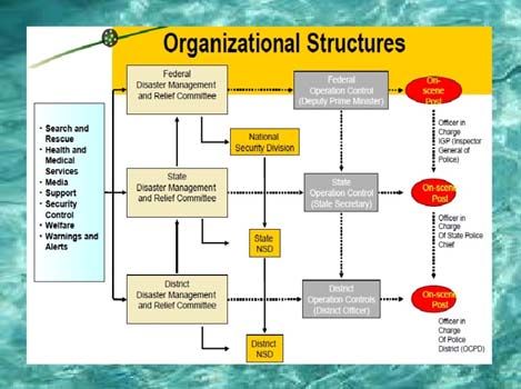
524In Malaysia, disaster management is almost entirely based on a top-down approach.
At the very top is the NDMRC running a National Crisis and Disaster Management
Mechanism (NCDMM). According to Chia (2004), this machinery was established
with the objective of co-coordinating relief operations at the Federal, state and district
levels so that assistance can be provided to flood victims in an orderly and effective
manner. In the case of floods, the NCDMM would be called the National Flood
Disaster Relief Machinery (NFDRM). The NFDRM is basically a reactive system, as it
reacts to major floods when they occur. The coordination of flood relief operations is
the responsibility of the National Flood Disaster Management & Relief Committee
(NFDMRC), headed by the Minister of Information with its secretariat at the National
Security Council (NSC). The committee is empowered, among other things, to declare
any district, state or even the whole nation to be in a state of disaster so as to be eligible
for financial assistance from the Federal Government. Members of this committee
include government departments/agencies and social organizations which provide
shelter, rescue and food supplies in case of disaster. On a positive note, the FFDMRC
meets at least once a year, normally before the onset of the northeast monsoon. The
meeting is between all organizations involved with flood disaster management on the
need to get ready before the monsoon arrives (bringing with it floods). It is to ensure
that its machinery will run smoothly. The entire organizational structure of the NFDRM
is shown in Figure 3.
The NFDRM is theoretically responsible for all operations at the national, state,
district, mukim and village levels. In reality, however, it coordinates operations at the
national level and overseas operations at the state level. Much of the activity in each
state is left to be run by the respective state authorities. Its main task is to ensure that
assistance and aid are provided to flood victims in an orderly and effective manner from
the national level downwards. As a result, its approach to disaster mitigation is largely
reactive (Chan, 1995). For example, this body meets annually just before the onset of
the northeast monsoon season to organize flood disaster preparedness, evacuation and
rehabilitation work. It is also more of a welfare body than it is a flood management
organization. At the federal level, the National Security Council (NSC) is the
secretariat for the Disaster Relief and Preparedness Committee (DRPC) which
comprises members from the Ministries of Information, Finance, National Unity and
525Social development, Transport, the Federal Chief Secretary, the Federal Police
Department and the Federal Armed Forces. The DRPC coordinates all relief operations
from the Malaysian Control Centre in Kuala Lumpur. At the state level, there are 13
State Disaster Relief and Preparedness Committees (SDRPC) for Malaysia. Each state
is given funds by the Federal Government every year to enable it to run its own disaster
relief operations. At the district level, there are several district committees under each
state, depending on the number of districts in a particular state. Each district will have
its own District Disaster Relief and Preparedness Committees (DDRPC) which receives
funds and directives from the SDRPC. Below the district level, there are several mukim
Disaster Relief and Preparedness Committees (MDRPC), again depending on the
number of mukim in each district. Each MDRPC is headed by a penghulu (County
Head). Finally, there are many Village Disaster Relief and Preparedness Committees
(VDRPC) under each mukim. Each VDRPC is headed by a ketua kampong (village
Head) (Figure 4). The National Disaster Response Mechanism (NDRM) is basically a
system responding to disasters, as its name suggests. As such, its approach towards
disaster management/reduction is largely reactive. Because Malaysia’s main type of
disaster is flooding, the NDRM is largely targeted at handling monsoon flooding.
Consequently, this mechanism is less than effective and should be re-modeled into
something more pro-active. There is also a serious lack in terms of stakeholder
participation, although the authorities have recognized the important role of NGOs,
particularly that of MERCY, the Red Cross, the Red Crescent and other NGOs. This is
likely due to heavy the dependence of communities on government, and the reluctance
of government to relinquish responsibilities to the public. Public apathy may also be a
reason for low public participation in disaster management. Capacity building is
therefore necessary. NGOs and other stakeholders should be involved right from the
beginning, from pre-disaster preparedness to rescue and reconstruction. NGOs would
be particularly effective in creating awareness and education on disasters. The disaster
management mechanism should also adopt more non-structural measures, use state-of-
the-art technology and cooperate internationally with other countries for addressing
transboundary disasters.
526You can also read