Impact of forest wildfires on components of mountain landscapes of the Baikal region
←
→
Page content transcription
If your browser does not render page correctly, please read the page content below
Volume 6 (2): 100-114 (2022) (http://www.wildlife-biodiversity.com/)                                                  Research Article

Impact of forest wildfires on components of mountain
landscapes of the Baikal region
Irina N. Bilichenko*1, Sergey A. Sedykh1, Natalia N. Kichigina1, Zehong Li2
1
 Sochava Institute of Geography SB RAS, Irkutsk, Russia
2
 Institute of Geographic Sciences and Natural Resources Research CAS, Beijing, China
*Email: irinsbilnik@mail.ru
Received: 28 June 2021 / Revised: 13 August 2021 / Accepted: 02 October 2021/ Published online: 07 November 2021. Ministry of
Sciences, Research, and Technology, Arak University, Iran.
How to cite: Bilichenko, I.N, Sedykh, S.A., Kichigina, N.N., Li, Z. (2021). Impact of forest wildfires on components of mountain landscapes
of the Baikal region, 6(2), 100-114. https://doi.org/10.5281/zenodo.6570597

Abstract
Forest wildfires cover vast territories of mountainous Siberia. As a result, the appearance of
the landscape changes completely, as well as the properties of its components. The paper
considers the impact of wildfires on the components of the mountain-taiga geosystems of the
Primorskii Range, which stretches along the western shore of Lake Baikal. This is the driest
area in the Baikal region, with Goletz and mountain-taiga landscapes, coupled with steppe
areas. Wildfires regularly occur during hot and dry periods in all zones of the range, especially
since 2015. We made landscape descriptions of the territory of the key site and compiled a map
of the landscape structure with conflagration fires overlapped with partially and, optionally,
completely burnt-out areas. The vegetation cover has suffered the most, and the characteristics
of the hydrological regime and the properties of soils have changed. The vegetation is at the
initial stage of recovery, and only a few species can be found in the herbaceous-subshrub cover.
The characteristics of the water regime, primarily the temperature on the pyrogenically
disturbed catchments, undergo significant changes. The mode of mineralization of streams is
unstable, and the amplitudes of water level fluctuations are higher due to the destruction of the
natural underlying surface of the catchment. The chemical composition of water in streams
after wildfires is generally preserved. Although, an increase in the concentration of nitrates and
hydrocarbons is possibly due to fires. Pyrogenic destruction of forest ecosystems inevitably
leads to the degradation of mountain soils, which are restored over many decades. After fires
in soils, acidity and, consequently, the content of organic matter decreases due to their
mineralization.
Keywords: Baikal region, mountain-taiga landscapes, mapping, wildfires
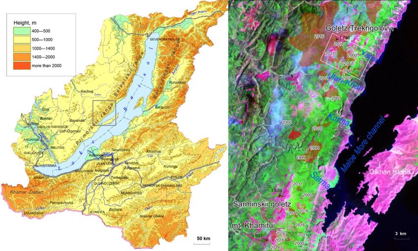
101 | Journal of Wildlife and Biodiversity 6(2): 100-114 (2022)

Introduction
An increase in the level of forest combustibility has been recently observed all over the world
(Kharuk et al., 2008). Both the frequency of forest combustibility and the area are increasing
(Kasischke et al., 2010). Forest wildfires have also become a real national disaster in Russia,
with 70–90% of the annual number of forest fires in Russia occurring in Siberia. In particular,
in Irkutsk oblast, with its vast territory and very low population density, there were more than
1,000 forest fires in 2019, and more than 1.5 million hectares of forest were affected
dramatically by burning. In 2018, 631 forest fires were registered on an area of 74 thousand
hectares, in 2017 there were 1 thousand 61 fires on an area of 235 thousand hectares. The
forests of the Ministry of Forestry of the Irkutsk Region are exemplified by a high degree of
natural fire hazard (State report., 2020). Fire hot spots, located in the so-called control zone (in
remote places where they are not extinguished due to economic inexpediency) account for a
large proportion of the total area of forest fires.
Mountainous areas covered by fires are also difficult to access. Therefore, they have large
spreading areas and represent the most important factors affecting the composition, structure,
and development of the components of mountain geosystems. The combustibility factor is
considered in (Suvorov, 2019) as a natural, constantly present factor of dynamic and even
evolutionary changes in geosystems. The landscape structure of mountainous regions consists
often of various stages of post-fire successions, which have different time intervals and are
accompanied by changes in the ecological appearance of all components of the geosystem
(Mayorova, 2013). This fact contributes to the diversity of the landscape structure of the Baikal
region. Often, the spread of conflagration fires coincides with the dominance of stable-derived
states of geosystems in the territorial structure (Suvorov et al. 2008, Bilichenko et al. 2018)
The lack of sufficient data on changes in landscape components under the influence of the
pyrogenic factor and the widespread occurrence of wildfires in the Irkutsk oblast, as well as
their impact on geosystems, determines the relevance of these studies. We carried out a detailed
study of the vegetation and hydrological characteristics, as well as the soil cover.
Study area
The paper is concerned with the impact of wildfires on the components of the mountain-taiga
geosystems of the Primorskii Range (Fig. 1 (left)), which extends for 250 km along the western
shore of Lake Baikal and has a maximum elevation of 1746 m on the Trekhgolovyi Goletz.
The key site belongs to the catchment area of Lake Baikal and is part of the Central ecological
zone of the Baikal natural territory. The results of comprehensive landscape studies in the
102 | Journal of Wildlife and Biodiversity 6(2): 100-114 (2022)

central part of the Primorskii Range, begun in 2012, are presented in several papers (Bilichenko
& Sedykh, 2016, Plyusnin et al., 2018, Kichigina & Bilichenko 2019, Bilichenko, 2021,
Plyusnin et al. 2020).

Figure 1. Location of the research area (left). The main wildfire spread areas in 1999-2017 on a mosaic
fragment of Landsat 7 ETM + Land Сover 2000 (USGS) satellite images.

Crystalline schists, gneisses, marbles, and other metamorphic rocks are widespread on the
slopes of the Primorskii Range and the shore of Lake Baikal. Quaternary detrital weathering
crusts and their derivatives are widely represented. Remnants of ancient clayey red-colored and
variegated weathering crusts (The ecological Atlas…, 2015) are found locally.
This area is the driest one in the Baikal region. On the southeastern macro slope, precipitation
ranges from 100-300 mm in the steppe regions to 350-450 mm in the mountain-taiga belt,
mainly in summer (the mean air temperature in July is 14.4°C). The winters here are dry, the
mean January air temperature is –17.3°C. (Atlas, 2004). V.S. Mikheev reports (1993), that the
landscape structure of the region has a clear differentiation by zonal-high-altitude belts. The
overstorey of the Primorskii Range is presented by subalpine sparse forest-taiga landscapes
with areas of mountain tundra. Most of the ridge is occupied by mountain taiga landscapes.
The Primorskii fault zone corresponds to the marginal parts of the horst ridges with subtaiga
and steppe landscapes (Abalakov, 2017).
Climate continentality and the extreme hydrothermal regime determine the peculiar features
and properties of soils. The modern soils of the region are predominantly immature and thin
103 | Journal of Wildlife and Biodiversity 6(2): 100-114 (2022)

and have strong and medium-stony profiles. Outcrops of rocks are often observed on slopes
and watersheds. During the growing season, there are significant fluctuations in soil moisture
with strong drying in the first half of the spring-summer period. The lack of atmospheric
moisture is exacerbated here by the high permeability of rubble-loam soils (Lopatina,
Belozertseva, 2020).
Sod (peat) podburs and sod (peat) podzols are widespread in the mountain taiga forests of the
Primorskii Range. Oligotrophic peat soils were formed in wide swampy hollows with close
permafrost rocks. Organo-accumulative gray-humic soils dominate in the soil cover of the
foothills of the Primorskii Range and the Priol’khonskoe Plateau. Soils of river valleys are
mainly represented by alluvial humic-gley, alluvial peat-gley, alluvial dark-humic and alluvial
gray-humic soils. Gray soils can be found near the slopes. In the foothill dry steppes of the
Olkhon region, chestnut and so-called chestnut-like soils were formed (The ecological Atlas,
2015).
Figure 1 (right) shows the main fire areas on the territory of the central part of the Primorskii
Range. Wildfires regularly occur during hot and dry periods within the subgoletz belt and in
all parts of the mountain-taiga belt of the Primorskii Range, especially since 2015.
Material and methods
In the summer of 2017–2019, we made field investigations at the experimental transect key
site ‘Trekhgolovyi Goletz - Yator tract' (Fig. 1 (right), white rectangle) as part of the complex
landscape-geographical expedition. Detailed descriptions of post-pyrogenic landscapes were
made in various locations, including also the natural landscapes that escaped the fire. To carry
out physicochemical analyzes, we took soils and rock samples.
Landscape analysis includes the mapping of landscapes and their dynamics. This is a spatial
display of temporal changes of various ranks under the influence of natural processes induced
by global and regional climate changes, as well as by pyrogenic and anthropogenic impacts.
The basis of the step-by-step mapping technique on the key site ‘Trekhgolovyi Goletz - Yator
tract’ with an area of 100 km2 was GIS processing of field, topographic and remote sensing
data. The core of the working set of remote sensing data includes images of Landsat 4 MMS,
5 TM, 7 ETM, 8 OLI for 1989-2020. These are comparable scanner scenarios for July (in
dynamics by years), since it is by July that the vegetation reaches its peak in the ultra-
continental mountains, and the cooling effect of Baikal, which still exists at the beginning of
summer, is no longer active by this time. Since 2015, the set of summer images of medium
resolution has been supplemented with satellite data from Kanopus B1-B6 and Sentinel 2,
which that year became available to the Baikal natural territory. For a digital elevation model
104 | Journal of Wildlife and Biodiversity 6(2): 100-114 (2022)

(DEM) for absolute heights (from 456 m to 1778 m – the Trekhgolovyi Goletz), as well as
models of steepness and slope exposure, we used radar data from ALOS and SRTM v.4.1. To
detail the mapped objects at a scale of 1: 50,000, ultra-high resolution (UHR) images were
used, made by Resurs-P spacecraft, operated by Roscosmos (Sangur-U with a maximum
resolution of 2 - 0.7 m), from the open resources of ScanEx-Yandex (satellite images for 2012-
2020) for non-commercial purposes.
At the preliminary stage, for the primary allocation of disturbed lands, classification algorithms
ISODATA (Iterative Self-Organizing Data Analysis Technique) and k-means clustering were
used as automatic data analysis methods. Further detailing included the calculation of NDVI
(Fig. 2) for the study area based on July Landsat 5 images for the following years: 1999, 2015,
and 2019.

            Figure 2. NDVI (B5-B4)/(B5+B4) Landsat 8 OLI, July 2019. Primorskii Range

The plots with a tree layer continuum, represented by dark coniferous (0.9-1) and light
coniferous forests (0.8-0.9) with dense undergrowth, are characterized by the highest NDVI
values at the key site during the period of maximum vegetation development. Smaller values
of the index correspond to mixed forests (0.6-0.7), and parvifoliate (0.5-0.6), sparse dry forests
(0.4-0.5), old (0.2-0.3) and partial (spot) fires (0.1-0.2), and steep petrophytic talus and
105 | Journal of Wildlife and Biodiversity 6(2): 100-114 (2022) steppificated slopes facing Lake Baikal (0.3-0.4). The most recent continuous burnt-out areas and lichen Goletz planation surfaces (less than 0.1) are characterized by the lowest terraneous phytomass and NDVI values. Using field GPS data on specific landscapes of the key site, we applied supervised step-by-step classification algorithms. For the testing ground, we used the maximum likelihood technique, the minimum distance method, and ECHO (Extraction and Classification of Homogeneous Objects) according to the Mahalanobis' generalized distance algorithm. The direct signs of interpretation and field data distinguish the landscape indicators in the supervised classification. These are compact fragments of unburned landscapes, eluvial outcrops of flattened summits of the central watershed, residual mountains of the spurs of the ridge, corroms and alluvial deposits of slopes, barren lands after fire events on summits, slopes, saddles, aufeis glades with Quaternary sediments and floodplains of watercourses in intermontane depressions. By indirect signs, we identified as follows: dry channels along concave slopes, permafrost saddles and depressions with depleted vegetation, typical plant aggregation within a belt, spot burnt-out areas. Local micro situations and negative changes are highlighted. Natural mountain-taiga geosystems have been preserved fragmentarily as standards, but not everywhere. The wildfire in 2016 damaged more than 50% of the study area. These are fragments of altitudinal-belt groups in refugia, as well as in ecotones (transition zones, for example, from a mountain-slope taiga to valley wetlands). Such refugia are highlighted by UHR images, where the resolution is larger than 15 m/px. The boundaries of spot burnt-out areas are often vague. In case of disturbances, the erosion, deflation and gravity- slope processes intensify, and the temperature regime changes the lithological base. Reconstruction of the original state of the landscapes before the fires required the use of Landsat 5 TM imagery and the creation of a location layer. The duration of the existence of most locations is measured in periods of n ∙ 103 ÷ n 104 years (where n is a coefficient for different types of locations), and they retain their features during fires [Isachenko]. The types of locations are distinguished on a differentiated scale, according to the steepness and the exposure of slopes. In terms of steepness, these are as follows: steep slopes (30-45°), medium steepness (20-30°), gentle (10-20°), flat slopes (4-10°) and horizontal surfaces (0-4°). The slope exposure affects the absolute height of the landscape belt. The DEM error with a resolution of 30 m reaches 10-20 m due to the presence of a tree layer in the mountain-taiga belt (before the fire and in unburnt areas). The next stage included the identification of the main types of landscapes before the fire and their groupings within the Goletz belt, subgoletz shrub (yernik- dwarf Siberian pine), the upper part of the mountain taiga light-coniferous–dark coniferous
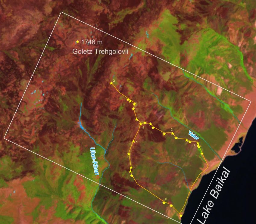
106 | Journal of Wildlife and Biodiversity 6(2): 100-114 (2022)

belt, and the lower light-coniferous part. To determine the characteristics of the destroyed
landscapes, we also used the benchmarking method in the least altered part of the range.
Furthermore, the study objects were small river catchments, which are the primary link in the
formation of river runoff and are most vulnerable to wildfires. To assess the effect of burnt-out
areas on the hydrological regime, modern measuring systems RAP-G-01 (IMKES, Tomsk)
were used, which automatically register the elements of the water regime (level, conductivity
and water temperature) with a 30-minute resolution. Such instrumentation systems were
installed in 2018 on the catchments of the Yator and Laninskii streams. Laboratory analyzes
were done using conventional methods at the licensed chemical analytical center of the
Sochava Institute of Geography SB RAS.
Results
Between 2015 and 2017, about 110 km2 of mountain-taiga and mountain-shrub geosystems
was burned out within the main watershed, on the western and eastern macroslopes on the key
area near the Trekhgolovyi Goletz (Fig. 3).

Figure 3. Key site ‘Yator tract - Trekhgolovyi Goletz - Ulan-Khan brook’ on the Landsat 8 OLI satellite
image (4-5-1, July 2017). 1-5 – the number of descriptions of landscapes from table 1.
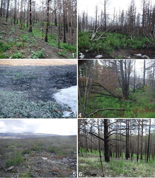
107 | Journal of Wildlife and Biodiversity 6(2): 100-114 (2022)

The study area belongs to the West-Pribaikalskii pyrological district - with a variation in the
number of fires from 0.1 to 0.5 per 100 thousand hectares per season. When characterizing the
pyrological districts, the assessment of the relief (height and dissection) and climate (seasonal
dynamics) was taken into account. (Sofronov, 1999). The climate is moderately cold and
humid. The general background is made of pine forests (Pinus sylvestris), and herbaceous-
subshrub. Dark coniferous subshrub-green moss forests are found along with the ranges. The
combustibility of forests is increased. The maximum wildfire hazard due to weather conditions
and the maximum combustibility occurs in spring, mostly in May.
Since 1999, 16 wildfires have been identified in the investigated part of the range, with an area
of about 500 km2. Among them, there was a catastrophic one in 2016 (more than 2000 ha) that
covered the watershed highlands north of the Trekhgolovyi Goletz. In addition, three
conflagration wildfires occurred later in this area and covered 201 to 2000 ha. The average area
covered by wildfires varies from 21 to 200 hectares. Conflagration wildfires are characterized
by a high degree of combustion when the stand is destroyed by 60% or completely. The soils
can be burnt out to the mineral layer (Fig. 4b).
About 20 detailed descriptions were made in the key area ‘Trekhgolovyi Goletz - Yator tract’.
Table 1 and Figure 4 show the examples of the descriptions. Most of the area was covered by
wildfire in 2016. In Goletz, at altitudes of 1400-1500m, there are places where dwarf Siberian
pine (Pinus pumila) burnt out completely (Fig. 4, c). At an altitude of 1380 m, there are areas
with burnt-out spots, yerniks (Betula nana), with rhododendron (Rhododendron aureum), and
lichen areas with burnt Siberian pine undergrowth (Fig. 4, d). Just below the slope, there is
Siberian pine (Pinus sibirica) with yernik and dwarf Siberian pine in the undergrowth of the
willowherb (Chamaenérion angustifolium) (Fig. 4, c). The southeastern macroslope is covered
with burnt pine stands with an abundant undergrowth of willowherb and celandine
(Chelidónium május) on an exposed stony substrate (Fig. 4, a). Willowherb communities are
also found higher, within the subgoletz zone among dead pine forests (Fig. 4, b). Near the Ulan-
Khan brook, on a steep slope at an altitude of 500 m, there is a pine herbaceous forest with
abundant aspen (Populus tremula) undergrowth (Fig. 4, f).
108 | Journal of Wildlife and Biodiversity 6(2): 100-114 (2022)

                                      Table 1. Landscape descriptions
 No.   Period       Location            Tree stand (h -     Herbaceous-subshrub     Soil
       after fire   (height, m;         height, d -                  layer
       (years)      steepness;          diameter)           Moss and lichen cover
                    exposure)           P - pine;           (abundance according
                                        B - birch;            to the Drude scale)
                                        O - aspen;
                                        S – Siberian pine
 1     2            Trekhgolovyi        P (h 10-15, d 20-   Willow tea (Cop3),      Stony
       Crawling     (700-900;           25) burned, snag    celandine (Cop 1)       substrate
       or surface   SE; 20-25°)         B,О snag
       fires
 2     2            Watershed           P (h 8-12, d 10-    Dwarf Siberian pine     Podzolic
                    divide (1200)       15) burned, snag    burnt                   typical
                                                            Willowherb (Cop 3)      pyrogenic
                                                                                    soils
 3     2            Plane surface       -                   Dwarf Siberian pine     Stony
                    (1400-1500)                             burnt                   substrate
 4     2            Down to the         S (h 10, d 15-20)   Dwarf Siberian pine     Podzolic
                    Ulan-Khan                               (Cop1)                  typical
                    Valley (1400)                           Yernik (Cop3)           pyrogenic
                                                            Willowherb (Cop 3)      soils
                                                            Lingonberry (Cop 1-
                                                            Sp)
 5     2            Trekhgolovyi        Snag of the         Yernik (Cop 1)          Ferruginous
       Burnt-out    (1380; W; 2-3°)     undergrowth S       Rhododendron (Sp)       illuvial
       spots                                                Lichen (Sp)             podburs and
                                                                                    coarse-humus
                                                                                    lithozems, as
                                                                                    well as humus
                                                                                    petrozems.
 6     3            Ulan-Khan           P (h 10-15, d 15-   Willowherb (Cop 3)      Sod-podzolic
                    (534; E; 20-25°)    20)                 Rock jasmine            Charcoal 3-4
                                        Shoots О            Lactiflorous (Cop2)     cm
109 | Journal of Wildlife and Biodiversity 6(2): 100-114 (2022) Figure 4. Post-pyrogenic geosystems of the Primorskii Range section (Ulan-Khan–Trekhgolovyi Goletz –Yator) 1-5 – the number of descriptions of landscapes from table 1 A landscape map was compiled for the territory of the key site with the situation before the major fires (2015-2016). The burnt-out areas are shown with translucent shading (Fig. 5).
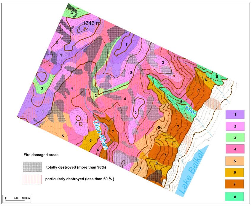
110 | Journal of Wildlife and Biodiversity 6(2): 100-114 (2022)

Figure 5. The retrospective map of the structure of geosystems for July 2015,
 рost pyrogenic situation for July 2019. Numbers of natural typological facies: 1. Goletz mountain-
tundra geosystem group on Lower-Proterozoic quartzites, and shale at 1742-1500 m with physical
weathering by gravity-cryogenic processes and nivation; 2. Subgoletz shrub and sparse-forest on shale
group of facies, plagiogneisses and amphibolites, at 1500–1400 m; 3. Subgoletz slope subalpine tundra
meadows at 1500-1400 м of reduced development conditions; 4. Subgoletz intermountain depressions
at 1400-1300 m. Bottoms of depressions with shrub and sparse larch; 5. Subgoletz Siberian pine and
larch sparse forest of limited development conditions at 1300-1100 m; 6. Low-mountain light-
coniferous forests (pine and larch) conditions of reduced development conditions at 1100-900
m; 7. Low-mountain watersheds and gentle slopes light-coniferous forests (pine and larch) of limited
development, at 900-600 m; 8. Intermountain valleys of limited development conditions (800-600 m).

Illuvial-ferruginous podburs and podzolic soils under birch-Siberian pine-larch Ledum-true
moss forest prevail at an altitude of 1560 m on the Trekhgolovyi goletz and the adjacent
territory under the dwarf Siberian pine subshrub-moss-lichen with single larch (Lárix sibírica),
undergrowth of birch (Betula pendula), and Siberian pine. In the depressions, there are gley
illuvial-ferruginous peat-podburs. Coarse humus lithozems prevail in treeless areas. In the
windswept saddle under yernik and Siberian pine lingonberry-moss-lichen dwarf, ferruginous
illuvial podburs and coarse-humus lithozems, as well as humus petrozems, are found. At the
border of the Siberian pine shrub-forb forest and the dwarf Siberian pine and yerniks on a gentle
111 | Journal of Wildlife and Biodiversity 6(2): 100-114 (2022)

slope of 3-4°, there are typical podzolic pyrogenic soils. On the plane surface of a slope with a
height of 1230 m, facing Lake Baikal, in the valley of the Ulan-Khan brook under a Siberian
pine-larch shrub-forb forest in place of an old burnt-out area with a violent grass-subshrub
cover, podzolic and sod-podzolic pyrogenic soils prevail. After wildfires, especially crown
fires, windthrow is common, and, as a result, soil erosion processes intensify in such areas.
The pyrogenic soils of the study area are characterized by a decrease in acidity and in humus
content due to their combustion in comparison with natural analogs of soil types. In the surface
pyrogenic horizons (Tpir, Hpir, AYpir) formed after the effect of the wildfire, a higher
concentration of chemical elements is observed: Ca increased fourfold, Mg – twofold, Cr –
sevenfold, Cu – fivefold, Mn – fourfold , Ni – twofold, Pb – twofold and Co – twofold. The
concentrations of Mn, Cr, Co, Ni, and Cu in the upper horizons of pyrogenic soils exceed the
maximum permissible concentration and approximate permissible concentration. An increase
in the concentration of trace elements in the upper pyrogenic turbocharged horizons of soils is
facilitated by the ash concentration effect and mixing of parent rocks with a high content of
heavy metals after wind blows.
To assess the influence of the pyrogenic factor on the hydrological regime, we selected the
catchment area of the Yator stream (Fig. 6) with an area of 10.5 km2. The catchment area of
the Laninskii stream with a total area of about 13 km2 also originates on the western slope of
the Primorskii Range below the Goletz zone at an altitude of 1100 m. The catchment area of
the Laninskii stream is located 30 km southwest of the catchment of the Yator stream in the
same landscape and climatic conditions as the Yator stream. The Laninskii stream was not
exposed to wildfires; therefore, we considered it as a baseline stream, preserving the natural
runoff regime.
The combined graphs of the river runoff parameters for the warm period of 2019 of the Yator
stream disturbed by wildfires and the Laninskii baseline stream show several significant
differences. Both the absolute values and the amplitudes of daily fluctuations in water
temperature are higher in the burnt-out catchment. This is especially true for daytime
temperatures. The surface of the burnt-out catchment area of the Yator stream warms up more
strongly during the daytime (Fig. 6a). The values of the conductivity in the burnt-out stream
are lower, but the diurnal and day-to-day fluctuations are more pronounced. At the same time,
a steady increase in mineralization is observed in the baseline stream during the autumn low-
water period (Fig. 6b). The nature of changes in the water levels of the streams is generally the
same, which indicates the same conditions for the formation of runoff. However, in the Yator
112 | Journal of Wildlife and Biodiversity 6(2): 100-114 (2022)

stream, the amplitudes of water level fluctuations are higher, the maximum levels are higher,
and the minimum ones are lower than in the baseline stream (Fig. 6c).

Figure 6. Matching curves of fluctuations in temperature (a), conductivity (b), and water levels
(c) in the Yator and Laninskii streams for the warm period of 2019.

Between 2017 and 2019, we took water samples from the streams to determine the
concentrations of the main ions and microelements, 8 samples of which were from the Ulan-
Khan and Yator streams after the wildfires and 9 from the baseline Laninskii stream. Overall,
according to the results of chemical analysis, the water is slightly mineralized, the ion content
in waters of the tested rivers varies from 30 to 80 mg/dm3. The waters of the streams belong to
the second and third types of hydrocarbonate-calcium waters according to O. A. Alekin
classification (1970). In the chemical composition of water samples after wildfires, we
recorded some differences from baseline watercourses. Thus, in the Ulan-Khan stream,
increased content of nitrate-nitrogen in the range of 1.03-1.32 mg/dm3 was registered, and in
113 | Journal of Wildlife and Biodiversity 6(2): 100-114 (2022)

the Yator stream – the increased content of nitrate-nitrogen in the range of 3.58-3.80 mg/dm3
and bicarbonate ion in the range of 40.9-70.2 mg/dm3. While in the baseline streams, the
content of nitrate nitrogen fluctuates in the range of 0.35-1.08 mg/dm3, and the content of the
hydrocarbonate ion in the range of 18.3-64.0 mg/dm3.

Conclusion
Thus, since 2015, a large area of the key site ‘Yator tract – Trekhgolovyi Goletz - Ulan-Khan
brook’ was subjected to wildfire almost completely, even changing the appearance of the
mountain-taiga landscape and its components. The vegetation cover has suffered the most, and
the features of the hydrological regime and soil properties have also changed.
Currently, the vegetation is at the initial stage of restoration, when only a few species are found
in the herbaceous-subshrub cover. The undergrowth of small-leaved species is not in place
everywhere, and Goletz dwarf Siberian pine landscapes are not yet restored at all. Furthermore,
this area is characterized by the phenomenon when wildfires occur almost every season, so the
landscapes are in a stable-long-term derivative state.
The water regime features in pyrogenically disturbed catchments undergo significant changes:
the water temperature regime changes due to an increase in daytime temperatures and
differences between day/night temperatures. The mode of mineralization in pyrogenically
disturbed watercourses is not stable, and the amplitudes of water level fluctuations are higher,
probably due to the destruction of the natural underlying surface of the catchment after a
wildfire. The chemical composition of water in streams after a wildfire is generally preserved.
An increase in the concentration of nitrates and hydrocarbons caused by fires is possible.
Pyrogenic destruction of forest ecosystems inevitably leads to the degradation of mountain
soils, which take many decades to recover. After wildfires, acidity decreases in soils, as well
as the content of organic matter due to their mineralization.
Acknowledgment
The publication was carried out with the financial support of the All-Russian public
organization ‘Russian Geographical Society’ Contract No. 11/2021-P and with the financial
support of the RFBR and GFEN of china within the framework of the scientific project No. 20-
55-53030 GFEN_a.
References
Alekin, O.A. (1970). Fundamentals of hydrochemistry.Hydrometeoizdat. [in Russian]
Abalakov, A.D., Novikova, L.S., Maryshkin, D.I. (2017). Landscapes of the Sarma scientific
     training ground on Lake Baikal. News of higher educational institutions. Volga region.
     Natural Sciences, 3(19), 78–90. DOI: 10.21685 / 2307-9150-2017-3-8
114 | Journal of Wildlife and Biodiversity 6(2): 100-114 (2022)
Atlas of the Irkutsk region: Environmental conditions for development (2004) In. V.V.
Vorobiev, A.N., Antipov, V.F., Khabarov. Irkutsk: Publishing house of the Institute of
Geography SB RAS; Moscow: Roskartografiya, 90 p.
Bilichenko, I. N., & Sedykh, S.A. (2016) Mapping the landscapes of the Western Baikal region.
Geodesy and Cartography, 9, 29-38.
Bilichenko, I.N. (2021) Landscape diversity of the Preolkhon region. Environmental
transformation and sustainable development in Asian region IOP Conf. Series: Earth and
Environmental Science 629 (2021) 012080 IOP Publishing doi:10.1088/1755-
1315/629/1/012080
Fires in the Irkutsk region in 2019 destroyed 1.5 million hectares of forest. https://tass.ru/sibir-
news/6758232
Kasischke, E.S., Verbyla, D.L., Rupp, T.S., McGuire, A.D., Murphy, K.A., et al. (2010)
Alaska’s changing fire regime – implications for the vulnerability of its boreal forests
Canadian Journal of Forest Research, 40(7), 1313-24. DOI: 10.1139/X10-098
Kichigina, N.N. & Bilichenko, I.N. (2019). Specificity of the river flow formation of small
mountain streams of the Baikal natural territory resulting from wildfires. Series: IOP
Conf. Series: Earth and Environmental Science 381 (2019) 012042 doi:10.1088/1755-
1315/381/1/012042
Kharuk, V.I., Ranson K.J. & Dvinskaya, M.L. (2008). Wildfires dynamic in the larch
dominance zone. Geophys. Res. Lett., 35(1), 1–6.
Lopatina, D.N. & Belozertseva, I.A. (2020). Natural and pyrogenic soils of the Primorsky
ridge. Bulletin of the Irkutsk State University. Series: Earth Sciences, 33, 73-87. DOI
https://doi.org/10.26516/2073-3402.2020.33.73
Mayorova, L.P., Sadykov, A.I., Sych, Yu.I. (2013). Impact of forest fires on ecosystems and
components of the natural environment (on the example of the Khabarovsk krai).
Scientific Notes TOGU, 4(4), 1-8.
Mikheev, V.S. (1993). Landscape-structural analysis. A man near Baikal: an ecological
analysis of the environment. Novosibirsk: Nauka, pp. 8–39.
Plyusnin, V.М., Bilichenko, I.N. & Sedykh, S.А. (2018). Spatiotemporal Organization of
Mountain Taiga Geosystems of the Baikal Natural Territory. Geography and Natural
Resources, 2, 130–9. DOI: 0.1134/S1875372818020051
Plyusnin, V. M., Bilichenko, I.N. & Sedykh, S.A. (2020). Study of the landscape structure of
the Olkhon region. Geography and natural resources, 5, 100–105.
DOI: 10.21782 / GIPR0206-1619-2020-5 (100-105).
Suvorov, E.G., Novitskaya, N.I. & Kitov, A.D. (2019) Temporal and spatial localization of
forest fires in the catchment basin of Lake Baikal. InterCarto. InterGIS, 25(2), 204-216.
The ecological Atlas of the Baikal basin (2015). Irkutsk: IG SB RAS, 145 p.
State report "On the state and protection of the environment of the Irkutsk region in 2019"
(2020). Irkutsk: Megaprint LLC, 314 p.You can also read