Hurricane Damages to Mangrove - and Post-Storm Restoration Techniques and Costs - The Nature Conservancy
←
→
Page content transcription
If your browser does not render page correctly, please read the page content below
Hurricane
Damages
to Mangrove

Forests
and Post-Storm Restoration
Techniques and Costs
Hurricane Damages to                                  We gratefully acknowledge the funding
                                                      of AXA XL and Builders Initiatve. In
Mangrove Forests and                                  addition, we’d like to thank our thoughtful
Post-Storm Restoration                                colleagues at The Nature Conservancy
Techniques and Costs                                  (TNC) who provided technical expertise
                                                      and insightful comments in the drafting
Jorge A. Herrera Silveira2                            of this report. These colleagues include
Claudia Teutli Hernandez3                             Lianna McFarlane-Connelly, Eric Roberts
Fernando Secaira Fajardo1                             and Mark Way.
Rod Braun1
Janet Bowman1                                         This report is the first of three reports to
Laura Geselbracht1                                    be released by TNC in collaboration with
Marcia Musgrove1                                      our partners at AXA XL, CINVESTAV, and
Martha Rogers1                                        the University of California, Santa Cruz.
Joseph Schmidt1                                       The reports are part of a year-long project
Pedro Javier Robles Toral2                            aimed at assessing the feasibility for a
Jesús Andrés Canul Cabrera2                           mangrove insurance project in the Gulf of
Lucia Guerra Cano2                                    Mexico and Caribbean. In this first report,
                                                      we document the types of mangrove
1. The Nature Conservancy, Arlington, VA
                                                      damages that may result from hurricanes,
2. Department of Marine Resources CINVESTAV-Merida,
                                                      the appropriate restoration techniques to
Yucatan, Mexico
                                                      adequately restore damaged mangroves,
3. Escuela Nacional de Estudios Superiores, Unidad
                                                      and the costs of these restoration efforts.
Méreida, UNAM
                                                      In the second report, we document the
                                                      protective value of mangrove forests in the
Photograph on the cover:                              study region. Finally, in the third report we
Defoliation and damages to mangrove struc-            aggregate information from the first two
tures in Sian Ka´an, Mexico                           reports and identify specific areas where
following Hurricane Ernesto                           a mangrove insurance product would be
@ Fernando Secaira.                                   most cost-effective. We also summarize
                                                      the efforts of our market analysis in Mexico,
Graphic Design:                                       Florida and The Bahamas and identify
.Puntoaparte Editores                                 specific locations where a mangrove
                                                      insurance product could be piloted. As
Suggested Citation: Herrera-Silveira, J. A.,          described in this report, tropical storms and
Teutli-Hernandez, C., Secaira-Fajardo, F., Braun,     hurricanes can cause significant damages
R., Bowman, J., Geselbracht, L., Musgrove,            to mangroves and restoration costs can be
M., Rogers, M., Schmidt, J., Robles-Toral, P. J.,     high. Financing these restoration activities,
Canul-Cabrera, J. A., & Guerra-Cano, L. 2022.         through innovative solutions like an insur-
"Hurricane Damages to Mangrove Forests and            ance product, will be critical to ensuring
Post-Storm Restoration Techniques and Costs."         that the protective benefits of mangroves
The Nature Conservancy, Arlington, VA.                are sustained in the future.
Table of Contents
        Introduction

  1
                                                                                         4

        Mangrove ecosystems                                                             6
        Hurricanes                                                                      8
        Hurricane frequency and intensity in the Gulf of Mexico and Caribbean           9
        Influence of climate change in tropical storms                                 11

 2
        Damage caused by hurricanes to mangroves                                       12

        Types of damage                                                                13
        Severity of damage caused by hurricanes                                        18

        Extent, location and severity of the damage                                    19

 3
        Species susceptibility                                                         20
        Forest structure: trunk size and tree height                                   21
        Ecological type of mangrove                                                    21
        Mangrove fragmentation or degradation                                          21
        Location of mangroves in relation to hurricane path and distance to the sea    22
        Frequency of hurricanes                                                        23

 4
        Actions to restore or repair damages                                           24

        Hydrological rehabilitation                                                    26
        Topographic rehabilitation                                                     29
        Reforestation                                                                  31

        Cost to restore mangroves

  5
                                                                                        32

        Identifying mangrove restoration costs in Mexico                               34
        Identifying mangrove restoration costs in Florida                              35
        Identifying mangrove restoration costs in The Bahamas                          36
        Mangrove restoration costs by approach or action                               37

 6
        Final considerations                                                           39

        References                                                                     41
        Appendix                                                                       46
Introduction
Mangrove forests provide important eco-          grove forests dissipate wave energy and       Mangroves in Alligator
                                                                                               Creek, Cat Island, Bahamas.
system services, such as habitat for fish and    slow storm surge penetration, which can
                                                                                               © Shane Gross.
crustaceans, water filtration, carbon seques-    lower flood damage and minimize erosion
tration, soil formation and protection against   (World Bank, 2016). Globally, mangroves
coastal erosion through soil stabilization,      provide coastal protection services that
sediment accumulation and amelioration of        avert $65 billion USD in damages and
storm surge (Cohen-Shacham et al., 2016;         flooding for more than 15 million people
Herr and Landis, 2016; IUCN, 2020).              each year (Menéndez et al., 2020).

Protection against tropical cyclones, which      Around the world, there are numerous
can be called typhoons or hurricanes de-         examples of coastal communities that have
pending on where they occur in the world,        been devastated by these storm events (see
is one of the most beneficial environmental      Figure 1). In 2004, an Indian Ocean tsunami
services provided by mangroves to human          caused major damage to infrastructure and
settlements near the coast. It is estimated      the death of more than 200,000 people
that approximately two-thirds of the world’s     (Check, 2005; Danielsen et al., 2005).
human population lives within 40 miles of        Hurricane Katrina devastated the United
the coast, which are highly vulnerable to        States’ Gulf of Mexico coastline in 2005
tropical cyclones (UN Atlas of the Oceans,       and was considered the most expensive
2016). Recent research shows that man-           hurricane to date (Costanza et al., 2006;

Hurricane Damages to Mangrove Forests                                                                                    4
2005                  2019                    2017                                                      2013
                     Hurricane          Hurricane              Hurricane                                                      Typhoon
                      Katrina            Dorian                 Maria                                                         Haiyan

                                                                     Arctic
                                                                     Ocean

                     North
                                                                              Europe
                    America
                                                                                                Asia

                                                                                                                                             30°N

                                                                               Africa

          Pacific                                         Atlantic
          Ocean                       South                Ocean
                                     America                                                        Indian
                                                                                                    Ocean

                                                                                                                                             30°S

                                                      Tropical storms (2000-2021)

          2015                2020                                                       2020                                     2016
      Hurricane       Hurricanes                                                        Cyclone                               Cyclone
       Patricia       Eta and Iota                                                      Amphan                                Winston

Day et al., 2007). Typhoon Haiyan in 2013               coastal erosion and rising mean sea level            Figure 1. Track of
was among the deadliest typhoons to hit                 have exacerbated the impact of tropical              tropical cyclones and
                                                                                                             historic storm events.
the Philippines.                                        cyclones (Nicholls and Casenave, 2010).
                                                                                                             Note: Graphic includes
                                                                                                             tropical cyclone and
The degradation and loss of mangrove                    In this report, we characterize the damages
                                                                                                             hurricane tracks globally
ecosystems as a result of deforestation and             caused by tropical cyclones to mangroves             from 2000 to 2021.
Earth’s changing climate has decreased their            and recommend actions to reduce or repair
                                                                                                             Source: NOAA’s Interna-
ability to provide these ecosystem services             damages to the mangroves. Although we                tional Best Track Archive
(MEA, 2005; Costanza et al., 2014; Zhao                 focus on post-storm restoration activities for       for Climate Stewardship
                                                                                                             (IBTrACS) data, accessed on
et al., 2016). Moreover, mangroves can                  damaged mangroves, many of the mangrove
                                                                                                             January, 2022. Made with
suffer great damage from tropical cyclones              restoration actions described can be applied         Natural Earth.
(Uriarte et al., 2019), which further limits            in other settings. We describe the range of
their capacity to provide these ecosystem               costs to repair mangroves in three priority
services. Larger economic losses have been              regions: Mexico, Florida, and The Bahamas.
reported as mangroves degrade and coastal               Mangrove restoration in these three regions
protection is compromised (Pendleton et al.,            has previously been shown to be highly
2012). In addition to mangrove degradation,             cost-effective (Beck et al., 2020).

Hurricane Damages to Mangrove Forests                                                                                                    5
Mangrove
ecosystems                                                                                                       13.8
                                                                                                                  million hectares of
                                                                                                                  mangroves globally
                                                                                                                      as of 2010

                                                                                                     Asia
                                                                      Europe
                      North
                     America

                                                                                                                                          30°N

                                              Atlantic                 Africa
                                               Ocean
      Pacific
      Ocean

                                     South
                                    America                                                      Indian
                                                                                                 Ocean

                                                                                                                                          30°S

     Mangroves

Mangroves are distributed in the intertidal              In 2010, due to the alarming rate                  Figure 2. Global
zone, along tropical and subtropical coasts,             of loss, the International Union for               distribution of
                                                                                                            mangroves as of 2010.
between 30° N and 30° S latitude (Giri et al.,           Conservation of Nature (IUCN) added
2011); about 75% of the world’s mangroves                11 of the world’s 70 mangrove species              Source: Global Mangrove
                                                                                                            Partnership Dataset,
are found in only 15 countries. The global               to the Red List of Threatened Species,
                                                                                                            World Atlas of Mangroves
coverage of these ecosystems is estimated                and six as Vulnerable Species (FAO,                (Spalding, 2010). Made with
at 13.8 million hectares (see Figure 2),                 2007; Polidoro et al., 2010). The                  Natural Earth.

however, deforestation of land for agriculture,          condition of a mangrove forest and
aquaculture, urban settlements and hotel or              extent of loss is strongly related to the
port infrastructure and changes in climatic              incidence of extreme weather events
and environmental processes (Thomas et al.,              (intense storms, tropical cyclones, or
2017) are rapidly degrading and destroying               tsunamis), oceanic processes (chang-
mangroves. Since 1980, more than 3.6 million             es in mean sea level or climate of
hectares of mangroves have been lost,                    marine circulations) (Gilman, Ellison,
accounting for more than 20% of the global               Duke and Field, 2008), and a variety of
mangrove coverage (FAO, 2007).                           human activities.

Hurricane Damages to Mangrove Forests                                                                                                6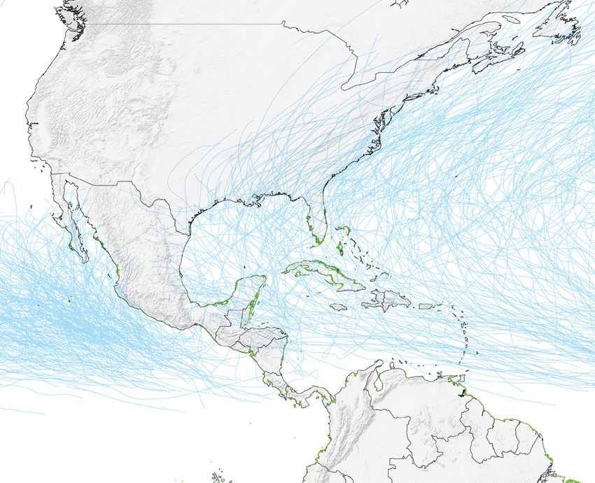
Mangroves are traditionally located in areas     (some Pacific islands and Central America’s      Oysters grow on the
                                                                                                  mangrove coastline of
exposed to disturbances (Lugo et al., 1981);     Pacific coasts), structural biomass and
                                                                                                  Charlotte Harbor Estuary
therefore, they are considered ecologically      complexity increases over time (Allen et al.,    near Punta Gorda, Florida
stable communities (Alongi, 2008) with the       2001; Simard et al., 2019).                      located on the Gulf of
                                                                                                  Mexico. © Carlton Ward Jr.
capacity to recover from damages caused
by tropical cyclones. The frequency and          The characteristics of mangrove forests
magnitude of tropical cyclones plays a role in   reflect the effect and recovery of previous
determining the composition and structural       disturbances and, in turn, influence the
complexity of a mangrove forest. For ex-         extent of the impact and the ecosystem
ample, in places where the tropical cyclone      response to future disturbances (Peters et
season is especially intense, the structural     al., 2011). Tropical cyclones could potential-
complexity of mangroves is characterized by      ly have greater impact on populated areas
shorter trees and few emergent taller trees      (Vogt et al., 2012; Lewis et al., 2016) where
(Lugo and Snedaker, 1974), whereas in areas      mangrove forests have been degraded or
where tropical cyclones are less frequent        destroyed as a result of human activities.

Hurricane Damages to Mangrove Forests                                                                                          7
Hurricanes
                                                                                                     5
                                                                    4
                                                                                                  157 mph or
                                                                                                    higher
                                                                                                   >252 km/h

                                                              130-156 mph
                                                              209-251 km/h

                                       3
                                   111-119 mph
                                   178-208 km/h

                    2
                                                                                                                                Cyclone
                                                                                                                              Storm Surge
                                                                                                         > 5.5 m               (Meters)
                 96-110 mph
                 154-177 km/h                                                  4–5.5 m                                            5

                                                            3–4 m                                                                 4
      1                                     1.8–2.4 m                                                                             3
  74-95 mph
  119-153 km/h                  1.2–1.5 m                                                                                         2
                                                                                                                                   1
                                                                                                                                  0

Tropical cyclones are natural phenomena                 ricanes when referring to tropical cyclones as   Figure 3.
that typically develop in warm waters.                  we focus our discussion on mangroves in the      Classification of
                                                                                                         hurricanes on the
Depending on their maximum sustained                    Gulf of Mexico and Caribbean, where tropical
                                                                                                         Saffir-Simpson scale
one-minute wind speed, they can be named                cyclones are referred to as hurricanes.
                                                                                                         (NPS, 2019).
and categorized as a tropical depression
                                                                                                         Adapted from Lucia
(low wind speed, less than 38 miles per                 The Saffir-Simpson scale classifies hurri-
                                                                                                         Guerra Cano.
hour), a tropical storm (moderate wind                  canes into five groups, with category five
speed, between 39-73 miles per hour) or a               being the most severe hurricane category
hurricane (severe wind speed, greater than              (NPS, 2019) (Figure 3). Hurricanes catego-
74 miles per hour) (NPS, 2019). The term                rized as three and above are termed major
“hurricane” is used for the most powerful               hurricanes.
tropical cyclones that develop in the Atlantic
Ocean and the Eastern Pacific Ocean, while              Conditions that are favorable for hurricane
tropical cyclones that develop in the West-             formation typically include a surface water
ern Pacific Ocean are called “typhoons.” For            temperature greater than 26°C, atmospheric
the remainder of the report, we will use hur-           humidity greater than 85%, and intense wind

Hurricane Damages to Mangrove Forests                                                                                             8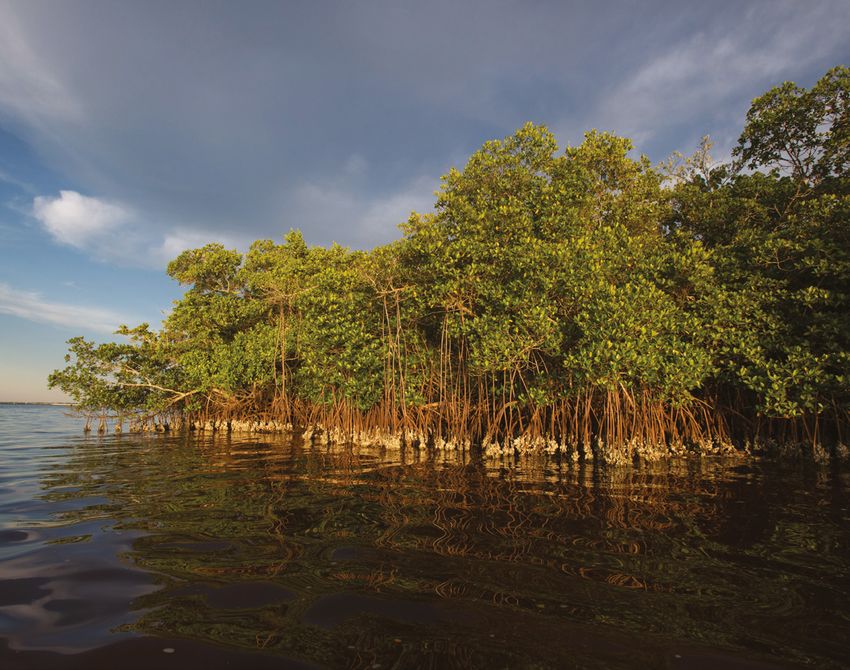
North
                                                 America

Hurricane frequency
and intensity in
the Gulf of Mexico
and Caribbean
                                                                                                     Atlantic
                                                                                                      Ocean
                                           Gulf of
                                           Mexico

Pacific
Ocean
                                                 Central              Caribbean
                                                 America                 Sea

  N

          Mangroves
                                                                                          South
          Tropical storms                                                                America
          (2000-2021)

               400 km

circulation due to the thermal difference            Over time, hurricane seasons have                  Figure 4: Track of
between the ocean and the atmosphere                 followed a polynomial tendency, where a            hurricanes, tropical
                                                                                                        depressions,
(Yáñez-Arancibia et. al., 2014). In the Atlan-       considerable decrease in the number of
                                                                                                        and tropical and
tic and Caribbean, the hurricane season is           storm events occurs every four to six years.
                                                                                                        subtropical storms
from June to November, while in the Pacific it       However, since 2016, the number of major           in Gulf of Mexico
begins in May and ends in November.                  hurricanes has increased, in part due to           and Caribbean
                                                     an increase in sea surface and subsurface          (2000-2021)
In the last 15 years, 250 hurricanes, tropical       temperatures and a decrease in atmospher-          Source: NOAA’s Interna-
depressions, and tropical and subtropical            ic circulation during the summer in the            tional Best Track Archive
                                                                                                        for Climate Stewardship
storms have impacted the Gulf of Mexico and          tropics (Taillie et al., 2020). This increase
                                                                                                        (IBTrACS) data, accessed on
Caribbean (Figure 4). Up to 2019, the average        in major hurricanes, together with other           January, 2022. Made with
number of named storms per season was 15,            effects of climate change such as sea level        Natural Earth.

including six hurricanes, of which three were        rise, could cause even more severe damage
major hurricanes (Taillie et al., 2020). The         to mangroves due to higher rates of coastal
2020 season was extremely intense with 31            erosion, more severe flooding, and stronger
storms, far above the average and surpassing         storm surges with more extensive inland
all recorded seasons (Figure 5).                     impact (Woodruff et al., 2013).

Hurricane Damages to Mangrove Forests                                                                                            9
30

                                                                                                                                                    25

                                                                                                                                                    20

                                                                                                                                                    15

                                                                                                                                                    10

                                                                                                                                                    5
category 3 and above
 Major hurricanes of

                                                                                                                                                    0
                       2006     2007    2008     2009    2010   2011   2012   2013   2014       2015      2016   2017   2018   2019     2020

                       The number of tropical storms that have affected man-                Figure 5: Number              Tropical Deppresions
                       groves in the Gulf of Mexico and Caribbean from 2009 to              and intensity of
                                                                                            tropical storm events         Subtropical Storms
                       2017 was 116, of which 46 were classified as hurricanes
                                                                                            per season in the
                       (Taillie et al., 2020). In 2017 alone, over one million                                            Tropical Storms
                                                                                            Gulf of Mexico and
                       hectares of mangroves were affected by tropical storms               Caribbean.                    Hurricanes
                       or hurricanes, the largest mangrove area to be affected by
                                                                                            Source: SMN, 2021.
                       storms in the last four decades (Taillie et al., 2020).                                            Major Hurricanes

                       Hurricane Damages to Mangrove Forests                                                                                   10
Influence of climate
change in tropical storms
As climate change intensifies, conditions These projections show that the negative The island of Petit St. Vincent,
Grenada. © Marjo Aho.
in the Atlantic Ocean become more effects of storms and hurricanes on
favorable for the formation of hurricanes. mangrove ecosystems will also increase in
Some authors predict large changes in the next several decades. Negative effects
tropical storm dynamics as a result of could include a reduction of organic matter
climate change, including an increase in and the replacement of mangroves by
the frequency of severe tropical storms; an open water. However, on a regional scale,
increase in rainfall from the hurricane; and future changes to mangrove ecosystems
an increase in the number of tropical storms are more complicated to predict (Krauss
and hurricanes that reach northeastern and Osland, 2020), since changing storm
United States, Canada, and even Europe dynamics interact with other global change
(Knutson et al., 2010, 2015; Christensen processes, such as sea level rise, erosion,
et al., 2013; Sobel et al., 2016; Kossin et al., and altered nutrient cycling (Osland et al.,
2017; Patricola and Wehner, 2018). 2018; Sippo et al., 2018).
Hurricane Damages to Mangrove Forests 11Damage caused
by hurricanes to
mangroves
Around the world, there are regions where canes, such as Australia, Mexico, Myanmar, Remnants of old pier and
mangroves are seen in
mangrove forests are not affected by the Philippines, Bangladesh, Cuba, and the
the erosion, Grenville Bay,
hurricanes because the climatic conditions United States. Small countries, such as The Grenada. © Marjo Aho
do not favor storm formation; for example, Bahamas, Guadalupe, Honduras, Belize
hurricanes rarely affect mangroves in Africa, and Haiti, which are home to large areas of
South America, Indonesia, and Papua New mangrove forests, are located in some of
Guinea. However, there are other regions the most active hurricane zones (Krauss
where mangroves are impacted by hurri- and Osland, 2020).
Hurricane Damages to Mangrove Forests 12Types of damage
Changes in structure,
Changes in
composition and
hydrology
biomass of mangroves
Changes in Changes in topography:
sediment elevations, channels
characteristics and outlets
Mangrove forests are an important barrier canopy, resulting in the modification of
to hurricanes along tropical and subtropical sediment dynamics, succession patterns,
coasts. Hurricanes impact mangroves nutrient cycles, and a deterioration of
with strong winds, storm surge, sediment forest structure and functions, and a
deposition, excessive flooding, and coastal decrease in biodiversity (Baldwin et al.,
erosion (Rodríguez-Ramírez et al., 2008; 2001; Herbert et al., 1999). The impact of
Islebe et al., 2009). hurricanes can be classified by damages to
the structure and composition of the forest,
Hurricanes affect the structure and changes to the topography (elevation,
composition of the forest by uprooting and channels, and outlets) of the area, changes
killing trees, breaking and knocking down to the hydrology, and changes to the
stems and branches and defoliating the characteristics of sediments (Figure 6).
Hurricane Damages to Mangrove Forests 13Changes in structure, composition and biomass of mangroves
• Defoliation • Decrease in distribution and
abundance of species
• Loss of biomass
(branches and trunks) • Change in species dominance
• Loss of mature trees by • Change in frequency distribution
uprooting and death of mature and juvenile trees
• Reduction of the • Opening of clearings in the forest
forest complexity
Changes in topography: elevations, channels and outlets
• Trees, branches and • Storm surge opens
sediments obstruct storm outlets in dunes
channels and outlets and barrier islands
• Influx of sediments raises • Storm surge erodes and/
the ground level of lagoons, or accretes the coastline
channels and flooded areas
Changes in hydrology
• Disruption of water flow • Change in salt/
due to fallen trees or freshwater balance
branches and/or sediment
• Change in the hydroperiod
erosion and accumulation
• Increase in flood level
Changes in sediment characteristics
• Sediment salinization
• Suspended particles
in the water column
• Changes in texture
and composition of Figure 6. Hurricane
damage to mangrove
organic matter
forests.
Adapted from Lucia
Guerra Cano.
Hurricane Damages to Mangrove Forests 14Root detachment. Wind gusts flooding period, salinity, nutrient
caused by major hurricanes can availability and sediment deposition
cause individual trees to be uproot- (which interferes with the exchange
ed partially or completely and die. of gases between the root and the
The survival of partially uprooted sediment) (Lewis et al., 2016).
trees will depend on the conditions Tree distribution can be affected
of the sediments and hydrological when changes in the environmental
Changes in regimen post-storm. conditions affect mangrove species
structure,
differently, favoring some species to
Reduction of complexity. The the detriment of others.
composition complexity of a forest refers to the
structural and floristic characteris- Change in species dominance.
and biomass tics and the degree of development Severe damage to dominant species
of the system. The impact to any in the mangrove forest facilitates
of mangroves of these characteristics will cause the establishment of new species
a decrease in the complexity or growth of species whose domi-
Damages to structure, composition of the forest. Variables used to nance was lower. This replacement
and biomass of mangroves are the evaluate changes in complexity are is caused by structural damage
most evident impact of hurricanes. the “value of importance” index (uprooting or death of individuals)
The damages consist of: (which measures the dominance and the change in environmental
of species), abundance, and the conditions that may favor the less
Defoliation. Strong gusts of wind distribution of different trunk sizes dominant species.
during hurricanes cause leaves to and average tree height. These
detach (i.e., defoliation). same characteristics should be Change in the distribution and
monitored over time to determine frequency of mature/juvenile trees.
Branch breakage. Strong winds the trajectory of recovery and the Mature trees with larger diameters
break or partially detach the resilience of the system. are more susceptible to damage,
branches of trees. Mature trees are so after a hurricane, juveniles may
affected the most as they have less Decrease in distribution and dominate the forest and mature
flexibility than younger trees. abundance. The impact of a individuals may be less frequent.
hurricane can rapidly transform the
Trunk breakage. The severity of the distribution and abundance of trees, Opening of clearings. A clearing is
disturbance is a function of the age generating conditions different an open area with no trees within a
of the community and size of the from those prior to the storm. The forest. Generally, they form natu-
trees. Older trees grow tall, strong, abundance can decrease due to the rally; however, this phenomenon is
solid and lack the flexibility to death of individual mangrove trees. exacerbated by hurricanes when
withstand wind forces. Individuals Trees may die immediately because trees are felled or uprooted.
with trunk diameters more than 20 of total detachment from the sub-
to 30 centimeters are susceptible strate or may die several months
to breakage during wind gusts later due to defoliation, partial
(Islebe et al., 2009). Younger and uprooting, and changes in environ-
smaller individuals or those with mental conditions that exceed the
smaller crowns are more flexible tolerance of each species. Condi-
and resilient. tions that are likely to be altered are
Hurricane Damages to Mangrove Forests 15intense rains can cause erosion can block channels, disrupting the
inland and transport sediments hydrological regime of the area.
downstream to interior lagoons
and channels. In addition, strong Changes in topography could cause
hurricanes often breach barrier three effects: (i) higher elevation,
islands and open new storm which reduces water flow and the
Changes in outlets, allowing salty water to exchange of salts and nutrients,
topography: enter the system. resulting in changes in the physical
and chemical characteristics of
elevations, This sediment transport can sediments; (ii) lower topographic
channels and produce significant changes in
topography, such as raising the
level, which raises flood levels to
exceed the height of the seedlings,
outlets bottom of lagoons and mangrove preventing their establishment
areas, blocking natural channels and survival (Flores-Verdugo et
Hurricanes can transport large where water used to flow, and al., 2010); and (iii) opening of new
amounts of sediments into the even blocking outlets to the sea. outlets/inlets between the sea and
coastal zone. Storm surge and Hurricanes can also produce huge wetlands, which can last for months
currents can transport and relocate amounts of debris, such as dead or years, affecting the salinity of
sediments along the coast, and trees and broken branches that mangrove forests.
pre-storm balance and changing cycles. (Paling et. al., 2008; Taillie
the chemistry of the marshes and et. al., 2020). When inlets are
lagoons as well as the amount of opened by the storms, saltwater will
water in the area. flow inland and permeate marshes,
lagoons, and other low-lying areas.
Changes in the hydroperiod. This Mangroves will survive or perish,
can occur due to the blockage of depending on the tolerance of the
existing outlets or the opening of species to these variations in water
Changes in new outlets. The period and level of characteristics.
flooding can increase or decrease
hydrology depending on whether outlets are Increases in flood periods and
blocked or opened. levels. The increase in tide and
As a consequence of topographic precipitation during storms can
and physical changes, the hydro- Changes in water characteristics. cause areas near the coast to
logical regime on which mangroves Obstructed channels and new increase their flood periods and
depend can be impacted in the outlets/inlets generally alter and levels, which impact a mangrove’s
following ways: reduce hydrological flows, which natural hydroperiod. The
can cause an increase in water consequences of these changes
Changes in the freshwater and salinity, an increase in sediment, an can range from the “drowning”
marine water balance. New con- increase in water temperature, a of seedlings or shrubby adults to
nections between sea and wetlands reduction in oxygen concentrations, increases in sulfide concentrations
will increase the flow of salty water an increase in sulfide concentra- and negative oxidation-reduction
into the wetlands, modifying the tions and/or variations in nutrient levels (>-350 millivolts).
Hurricane Damages to Mangrove Forests 16accelerated degradation of vegeta- the composition and type of sedi-
tion, affecting the forest structure ments. Heavy rains and increases in
and loss of ecosystem functions. tide level can cause the deposition
of sediments and organic matter
Burial of propagules. Accretion in mangroves. In addition, winds
caused by storm surge can increase and waves can loosen underground
the elevation of the soil and bury biomass, resulting in the reduction
Changes in propagules. of soil consistency, favoring its
sinking and causing changes in
sediment Hypoxia. Sediment deposition the topography and hydroperiod
can change water flows, which (Mazda et al., 2002; Teutli-Hernán-
characteristics subsequently may cause hypoxia dez and Herrera-Silveira, 2016).
(Cahoon et al., 2002; Smith et
Sediment salinization. In areas al., 2009). Tidal sediment depo-
where the water flow is interrupted, sition can limit the exchange of
Mangroves along the coast of Warderick
the concentration of salts can per- gases between soil and roots, also Wells Cay in the Bahamas Exuma Cays Land
meate the sediment. Inlets opened causing hypoxia. & Sea Park. © Mark Godfrey/TNC.
by the storm can allow greater
intrusion of seawater, thus modify- Changes in texture and organic
ing the physicochemical conditions matter composition. The deposi-
of the sediments. This can result in tion of new sediments can change
Hurricane Damages to Mangrove Forests 17Severity of damage
caused by hurricanes
MINIMUM
1. Slight defoliation
2. Breakage of small branches
3. Suspended particles in water column
MODERATE
1. Small and medium branch breakage
2. Moderate flooding (up to 2.5 meters)
3. Moderate channel sedimentation
EXTENSIVE
1. Breakage of large branches
2. Large volumes of fallen woody material
3. Extensive flooding (2.7 to 3.6 meters)
4. Hydrological flow disruption
5. Sediment salinization
EXTREME
1. Large trees downed/uprooted
2. Change in structure and composition
(height and size)
3. Extreme flooding (3.9 to 5.5 meters)
4. Sea water intrusion
5. Opening of inlets through barrier
islands or dune systems
CATASTROPHIC
1. No presence of seedlings or juveniles
2. Large trees downed/uprooted
3. Decrease in density and complexity
4. Catastrophic and prolonged flooding
(higher than 5.5 meters)
5. Sediment salinization
6. Opening of inlets through barrier islands
and dune systems
The severity of damage caused by hurricanes to mangroves depends on Figure 7. Extent of damage to mangroves
the condition of the mangroves and on the characteristics of the hurricane based on hurricane intensity, using the
Saffir-Simpson scale. Modified from
(intensity, wind speed, storm surge, size). Krauss and Osland (2020)
Krauss and Osland, 2020.
propose a description of damages by hurricane intensity (Figure 7).
Hurricane Damages to Mangrove Forests 18Extent, location
and severity of
the damage
The extent and severity of mangrove forest When a hurricane makes landfall, it trans- Vegetation and mangrove
crowd the shoreline of
damage that results from a hurricane is fers its energy to the coastal system, where
the Sian Ka’an Biosphere
not homogeneous and varies depending on the fringing mangroves along the coastline Reserve in the Pez Maya
several factors. During the 2009 to 2017 receive the most violent impact (Carrillo area of eastern Yucatan
Peninsula in Mexico. ©
hurricane seasons, Taillie et al. (2020) et al., 2008). The proportion of damaged
Edward Porter/TNC
estimate mangrove damage to range from trees is higher in areas where there is a
86,439 to 133,662 hectares across the Gulf connection to open water.
of Mexico, Caribbean, Central America,
and South America. Other studies have Below, we describe well-documented
found that the biomass of dead mangroves factors that have contributed to the extent
following a hurricane can reach 150 tons and severity of mangrove damage in the
per hectare (Sánchez and Islebe, 1999). Gulf of Mexico and Caribbean.
Hurricane Damages to Mangrove Forests 19Species Laguncularia
susceptibility Conocarpus
racemoza
erectus
Avicennia
germinans
Rhizophora
mangle
The susceptibility of different mangrove defoliated and uprooted by strong winds.
species to strong winds has been widely Similar to Avicinia germinans, it can grow
discussed by several authors. Kovacs et back if pore water salinity is below 40
al. (2001) found that Rhizophora mangle ups. When L. racemosa´s trunk is fallen
is more resistant to hurricane winds but roots remain alive, it will grow back
than Avicennia germinans; however, and spur branches that will grow vertically
Smith et al. (1994), Imbert et al. (1996) as new trunks, as witnessed by Herrera´s
and Ross et al. (2006) had the opposite field experience. However, when major
conclusion. And finally, Sherman et al. hurricanes occur, there are no significant
(2001), Milbrandt et al. (2006) and Smith differences between species because the
et al. (2009) could not find differences wind gusts and storm surge are so violent.
in wind susceptibility between the two
species. Several authors have reported Krauss and Osland (2020) conducted an
that Rhizophora mangle is more damaged analysis in the Caribbean and suggest that
than Avicennia germinans and Conocarpus the tolerance of each mangrove species to
erectus when a low category hurricane hurricanes is influenced by the conditions of
occurs (Imbert et al., 1996; Galeano et al., each site, the ecological type of mangrove,
2007). Another species present in the and the wind, rain, waves, and sedimentation
Caribbean, Laguncularia racemosa, can be generated by the particular storm.
Hurricane Damages to Mangrove Forests 20Forest
structure:
trunk size and
tree height
Individuals whose trunks have a diameter
greater than 20 centimeters suffer more
damage than individuals with smaller
diameters since the wider the trunk the less
flexible they are to resist wind gusts
With basin mangrove forests, storm
Figure 8. Impact of
In mature mangrove forests, smaller trees surge deposits sediments which raises hurricane winds in
can resist strong winds more effectively, soil elevation, potentially drowning the mangrove forests,
as opposed to taller trees, which are more vegetation and/or altering the salinity of the where the tallest trees
likely to suffer breakage (Islebe et al., 2009; system (Smith et al., 2009; Imbert, 2018). are the most affected
Roth, 1992). Imbert (2018) reported that in It has been observed that basin mangroves by the passage of a
hurricane.
mixed forests, the tallest species, R. mangle, are more affected by tropical storms than
suffered more lethal damage (80% of basal riverine, marginal and insular mangroves. Adapted from Javier
Robles Toral.
area loss) compared to A. germinans (20% of However, basin mangrove forests present a
basal area loss) (Figure 8); the latter suffered faster natural recovery because their primary
lethal damage only when impacted by winds productivity is higher (Imbert and Portecop,
above 77 miles per hour. 1986; Imbert and Rollet, 1989).
Ecological type Mangrove
of mangrove fragmentation
or degradation
The ecological type of mangrove plays an
important role in the severity of damage
caused by storms and hurricanes. Hydrolog-
ical and geomorphological characteristics of Coastal development and aquaculture have
the site determine the mangroves ecological fragmented coastal ecosystems, including
type, which in turn determines the structure mangroves. Fragmentation affects the
and composition of the ecosystem (Lugo structure of the vegetation and hydrological
and Snedaker, 1974). flows, making them more susceptible to
damage caused by natural phenomena such
Fringing mangroves are located parallel as tsunamis and hurricanes. In the Caribbean,
to the coastline and next to the sea and mangroves located near populated areas and
are the first to be impacted by hurricanes within the usual path of storms and hurri-
(Carrillo et al., 2008). They suffer more canes are more prone to damage due to the
damage than other mangrove types. weakening of their structure (MEA, 2005).
Hurricane Damages to Mangrove Forests 21Location of Trajectory
mangroves
in relation to
hurricane path
and distance Left front
quadrant
Right front
quadrant
to the sea
Moderate
Intensive
rains and
winds
rains
Hurricane
The vulnerability of mangroves to loss or Eye
Some tornados
temperatures
damage from hurricanes is influenced by
Maximum
hurricane
and high
winds
H u rr
their location in relation to the path of the icane eye wall
hurricane, their exposure to the open sea, and
the distance from the center of the hurricane Left Right
posterior posterior
(Baldwin, Egnotovich, Ford and Platt, 2001; quadrant quadrant
Platt, Doren and Armentano, 2000).
The position of mangroves in relation to the
path of the hurricane has a significant effect
on the intensity of damage to the vegetation.
In the Northern Hemisphere, the pressure
exerted by wind and waves on the right side
of a hurricane can be up to 25% greater Trajectory
than on the left side (Stanturf et al., 2007).
Therefore, most hurricanes cause more
damage on the right and front sides of the
path of the eye. It has been observed that in
the quadrants to the right of the hurricane The location of mangroves in relation to the Figure 9. Hurricane
path, the damage caused by Category 1 open sea is also a determinant of damage. zoning diagram. In the
northern hemisphere,
hurricanes are similar to those caused Mangroves located on the shoreline and
the right quadrants
by Category 4 hurricanes (NASA, 2017). adjacent to open water will suffer the
represent the
According to Novlan and Gray (1974), in the greatest damage from waves and storm hurricane’s strongest
Caribbean, the most affected mangroves surge (Carrillo et al., 2008; Long et al. 2016). rainfall and winds.
will be those located in the eye walls and Mangroves located on the landside of the Adapted from Javier
in the front and rear right quadrants during system are generally composed of species Robles Toral.
the passage of the hurricane (Figure 9). with poorly developed root systems, such as
The severity of damage decreases with Conocarpus erectus and Laguncularia racemo-
increasing distance from the path of the eye sa. They are, therefore, more vulnerable to
of the hurricane (Dahal et al., 2014; Carrillo strong winds and severe damage has been
et al., 2008; Long et al., 2016). observed (Long et al. 2016).
Hurricane Damages to Mangrove Forests 22Frequency of hurricanes, as has been observed in
of hurricanes recent years (Kossin, 2020), can disrupt
mangroves’ natural recovery and lead to an
accumulation of damage (Taillie, 2020).
Mangroves in the Gulf of Mexico and Frequently impacted mangroves will have
Caribbean adapted to be resistant and higher tree mortality, broken branches and
resilient to Category 1 and 2 hurricanes and defoliation, resulting in greater organic mat-
can naturally recover in less than five years ter decomposition, increased soil formation
(Danielson et al., 2017), but recovery may and more compact soil (Snedaker, 1995; Aerial photography of Punta
take longer (up to 20 years) when man- Lang’at et al., 2014). These layered soil Gorda, on Florida’s Gulf of
Mexico coast at the north
groves are impacted by major hurricanes of conditions, along with standing water, can
end of Charlotte Harbor
Category 3 and above (Imbert, 2018). An hinder the mangroves´ natural regeneration near the mouth of the Peace
increase in the frequency and/or severity (Sherman et al., 2000; Cahoon et al., 2003). River.. © Carlton Ward Jr.Actions to restore
or repair damages
Key deer crossing Coupon
As noted above, mangroves can naturally The type of mangrove restoration and Bight to forage on mangrove
recover following a hurricane event. repair needed will depend on the type island in Big Pine Key,
Florida. © Valerie Preziosi.
This recovery, however, can take several and magnitude of the disturbance, as well
years leaving the mangroves vulnerable as the environmental context in which it
to additional storm damage while they occurs. In all scenarios, it is recommended
are in the process of recovery. Active to apply a suite of actions and procedures
restoration and repair of mangrove to ensure successful mangrove recovery
forests following hurricane damage can (Twilley and Rivera, 2005). There are four
quicken their recovery and enhance main steps in the design phase (Field,
their resilience to future hurricanes. 1999, Teutli-Hernández et al., 2020):
In this section, we describe common
techniques for repairing and restoring 1 Characterize the physical
mangroves. While we discuss mangrove
and ecological conditions
restoration and repair in the context of
addressing hurricane damage, many of of the site.
the techniques described in this section 2 Identify the factors
can also be applied to restore mangroves regulating the dynamics of
that were not specifically damaged by a
hurricane event. Indeed, there is growing
the site.
interest and investments in ecological 3 Identify the causes of
restoration of mangrove ecosystems degradation.
(REM) (Mckee and Faulkner, 2000; Balke 4 Locate the source of seeds
et al., 2014; Dittmann et al., 2019).
and seedlings.
Hurricane Damages to Mangrove Forests 24Mangrove Restoration Approaches Hydrological rehabilitation Removal of sediment, creation and maintenance of channels for water flow recovery. Topographic rehabilitation Modification of ground level according to sea level. Reforestation Planting mangrove seedlings. Recommended only when hydrological and topographic conditions are suitable for mangrove growth. Figure 10. Common approaches to mangrove restoration. Hurricane Damages to Mangrove Forests 25
The restoration actions commonly carried out can be grouped into three approaches, summarized in Figure 10.

Actions involved in hydrological rehabilitation

 DREDGING                                   REHABILITATION OF                      OPENING NEW
 CHANNELS                                   WATER CHANNELS                         CHANNELS

The objectives of hydrological and               water salinity, temperature, turbidity and       Figure 11. Actions
topographic rehabilitation are to initiate or    dissolved oxygen concentrations, as well as      involved in the
                                                                                                  hydrological
accelerate the recovery of environmental,        to the dispersion of propagules and seeds
                                                                                                  rehabilitation of
hydrological, and physicochemical con-           from healthy areas to the restoration site.      mangrove forest
ditions that enable the establishment of         Hydrological rehabilitation includes clearing    (Teutli-Hernández et
vegetation and the return to an ecologically     of waterways and natural channels, exca-         al., 2020).
and functionally stable ecosystem (SER,          vation of new channels and maintenance of        Photos courtesy of
2002). However, natural regeneration             existing channels (Teutli-Hernández et al.,      Primary production
has an important role to play. Mangroves         2020) (Figure 11).                               laboratory-CINVESTAV.

recovered naturally in Guanaja, Honduras,
20 years after the impact of Hurricane Mitch     Hydrological rehabilitation begins by
in 1998 with similar results to reforestation    characterizing the site using aerial images
projects in the same area (Fickert, 2020). It    and topographic assessments to identify
is recommended that all restoration projects     areas where water flows have been altered,
involve local stakeholders in the restoration    the routes of natural flows (freshwater
as community understanding of the purpose        or marine), possible trajectories for new
and value of the project enhances long-term      channels, and channels that need mainte-
project success (TNC, 2021). Conversely,         nance (Teutli-Hernández et al., 2020).
poor management and limited consideration
of ecological factors are the main reasons for
failed restoration projects (Teutli-Hernández,   Dredging Channels
2017; Beck et al., 2020).
                                                 Dredging is the removal of sediments

Hydrological
                                                 and debris deposited during the storm to
                                                 recover the drainage capacity and optimize
                                                 the circulation of water from one site

rehabilitation                                   to another. It is necessary to remove all
                                                 organic and inorganic material that obstructs
                                                 water circulation, maintaining the original
The main objective of hydrological reha-         characteristics of the channels (width, depth,
bilitation is to reestablish the hydrological    extension, and direction, among others). It
flows, which are essential to maintain           is essential to keep all the material removed

Hurricane Damages to Mangrove Forests                                                                                     26
1 2
Identify water flows Obstacle release
Through aerial imagery, Removal of material
on-site survey and obstructing the flow of
knowledge of local water and rehabilitation
communities. of the channels according
to the characteristics.
3
Organic matter
relocation
Relocation of organic
material within project
site. Organic material shall
continue decomposing
and provide nutrients.
from the channels within the area to be has been one of the main causes of man- Figure 12. Process
restored, since this dredged material makes a grove degradation and decreased resilience for the dredging of
natural canals (Teutli-
considerable contribution to carbon storage to hurricanes, mainly due to the loss in
Hernández et al.,
(Teutli-Hernández et al., 2020) (Figure 12). hydrological connectivity and limited fresh-
2020).
Place the dredged organic and inorganic water inputs (Lewis III, 2005; Wemple et al.,
Photo courtesy of
material on the sides of the channels to 2017; Teutli-Hernández and Herrera-Silveira,
Primary production
minimize erosion, improve the flow of water, 2018). Properly designed culverts allow laboratory-CINVESTAV.
and improve the dispersion of propagules. water flows to connect wetlands. However,
most culverts do not meet the minimum
In some cases, dredging is sufficient to requirements to allow an adequate exchange
recover the hydrology of the site and the of water. Adapting these already existing
physical and chemical characteristics of the culverts to allow an adequate exchange of
water and sediments, allowing the survival of water from well-preserved mangroves to
individuals and facilitating the establishment disturbed mangroves may be sufficient.
of vegetation (Teutli-Hernández et al., 2020).
Teutli-Hernández et al. (2020) suggest that
Rehabilitation of culverts have an “approaching” V shape in
both sides, widening immediately below the
water crossings road towards the channels. The diverging
lines of the “V” should have a length of at
Road construction that disrupts the hydro- least five meters, a minimum depth of one
logical characteristics of coastal wetlands meter, and connect with new or natural
Hurricane Damages to Mangrove Forests 275m
OUTLETS WITH SIDES WITH INTERCONNECTION
V SHAPE 5 METERS IN Y SHAPE
channels, resembling a “Y.” This adaptation For the excavation of these flow ways, it is Figure 13. Structural
in the structure of the culvert allows for recommended to use a system of “networks,” characteristics in the
rehabilitation of water
better water circulation, as well as a greater which allow the water to be conveyed more
crossings (Teutli-
range of water flow, even when there are efficiently from one site to another. The use
Hernández et al.,
low tides or increases in the hydroperiod, as of networks ensures the continuous flow 2020).
in the case of hurricanes (Figure 13). of water without causing a new overflow
Photos courtesy of
(Teutli-Hernández et al., 2020). Preferably,
Opening new
Primary production
this system of networks would follow a laboratory-CINVESTAV.
“zig-zag” arrangement, with a system of
channels main channels excavated at an angle of 45°
to 90° with respect to the water source and a
The opening of new channels in degraded system of secondary channels, which should
areas should be considered only when originate at an angle of 30° to 45° with
dredging natural channels is insufficient for respect to their main channel. (UNEP-Nairobi
the recovery of hydrological flow, or when Convention, USAID and WIOMSA, 2020) Figure 14. New
natural channels were not identified. For (Figure 14). The depth and slope of the chan- channels enable
hydrological
example, the opening of a new channel may nels will depend on the tide level, preferential
rehabilitation (Teutli-
be appropriate when the topography of the flows, and information obtained during site
Hernández et al.,
terrain was raised by sediment deposition characterization. Again, it is recommended 2020).
resulting in existing channels becoming that the sediment and material removed
Photos courtesy of
silted in (Ramasubramanian and Selvam, be kept within the perimeter of the project Primary production
2011; Teutli-Hernández et al., 2020). (Teutli-Hernández et al., 2020). laboratory-CINVESTAV.
The positioning and Deposit the extracted Combine in “zig-zag“
distribution of the channels material on the banks of the arrangement with other
should resemble the natural canals to avoid the expansion of channels to increase
configuration of the site the canals heterogeneity
Hurricane Damages to Mangrove Forests 28SEDIMENT CONDITIONING OF
CONTROL DISPERTION CENTER
Topographic
allow the establishment of seedlings Figure 15.
Actions involved
(Teutli-Hernández et al., 220) (Figure 15).
in topographic
rehabilitation
rehabilitation of
Sediment removal mangrove forests
(Teutli-Hernández et
al., 2020).
The hydrological characteristics of The removal of sediment and organic Photos courtesy of
mangroves are closely related to the mi- and inorganic material aims to level the Primary production
crotopography of the site and, in turn, both site by reducing the ground elevation laboratory- CINVESTAV.
determine the establishment of species and (Teutli-Hernández et al., 2020). When
the structure of the vegetation (Pérez-Ce- combined with the maintenance of water
ballos et al., 2017). As explained in section passages, the dredging of natural channels,
2 changes in topography could cause two and the creation of new channels, this
effects: (i) higher elevation, which reduces action increases the resilience of the man-
water flows and the exchange of salts grove system and encourages repopulation
and nutrients, resulting in changes in the by different species, favoring functional
physical and chemical characteristics of diversity, the process of secondary succes-
sediments and (ii) lower topographic level, sion, and providing a greater probability of
which raises flood levels that will then more recovery after a natural or anthropogenic
easily exceed the height of the seedlings, impact (Zedler, 2005).
preventing their establishment and survival
(Flores-Verdugo et al., 2010). It is recommended that the removed
sediment be used to create dispersion
The objective of topographic rehabilitation centers or to fill sites with lower levels.
is to adapt the level of the land in relation These sites receiving the sediment should
to the mean sea level. In most cases, it is be identified by a topographic survey
possible to use a nearby body of water and of the field that is then used to create
mangroves that are in good condition as ref- a digital elevation model (DEM). The
erences. Leveling can be done by removing DEM can be used to create a network of
sediments to reduce the height of the preferential flows and to identify historic
terrain or by the establishment of dispersal flow ways (Figure 16) (Teutler, 2005;
centers—raised platforms or terraces—to Teutli-Hernández et al., 2020).
Hurricane Damages to Mangrove Forests 29Identification of areas with a low Filling and transfer of sediment The organization of community
topographic level by topographic and organic material to areas members is recommended for
modeling and mappimg with a low topographic level this activity
Preparation of other actions since they promote greater
dispersion centers
Figure 16. Sediment
survival at a lower economic cost (Febles- removal during
topographic
Patrón et al., 2009; Thivakaran et al., 2018).
rehabilitation (Teutli-
The creation of dispersion centers consists It is important to consider that the number,
Hernández et al.,
of the construction of raised platforms to spacing and characteristics of the dispersal 2020).
counteract periods of high flooding and tidal centers will be a function of the conditions
Photos courtesy of
flows (Thivakaran, 2017). The shape of these of the area to be restored and the objectives Primary production
platforms can be circular, square or irregular and goals of the restoration (Teutli-Hernán- laboratory-CINVESTAV.
and should be built with sediment dredged dez et al., 2020).
at the site. These platforms facilitate the
establishment of seeds and propagules with The heights of the dispersion centers should
the goal of inducing natural regeneration or be varied to allow for the establishment of Figure 17. lllustration of
setting the stage for artificial reintroduction different species. The dispersion centers dispersion centers with
different topographic
(Figure 17) (Teutli-Hernández et al., 2020). can be created, in part, through the reuse
levels to generate
of material from other areas of the site, as heterogeneity in the
The use of dispersal centers for ecological long as it is permeable and not washed away landscape (Teutli-
restoration can produce better results than (Figure 18) (Thivakaran et al., 2018). Hernández et al., 2020).
Rhizophora sp. Rhizophora sp. Avicennia sp.
Avicennia sp.
UNDER CONSTRUCTION
Hurricane Damages to Mangrove Forests 30Geotextile mesh or shade cloth Backfilling with sediment from the site Heterogeneity among dispersion centers
Additionof sand (20% or 30%) to loamy Minimun spacing of one mether between
Stakes (1 or 2 meters high)
or clayey soils dispersion centers
Reforestation Nurseries are an expensive alternative
to support reforestation since they
involve raising seedlings year-round
Figure 18.
Conditioning of
dispersion centers
(Teutli-Hernández et
One of the most widely used techniques regardless of the natural cycle of the
al., 2020).
for mangrove forest restoration has species. Additionally, it has been
Photos courtesy of
been reforestation using propagules or observed that seedlings from nurseries
Primary production
nursery-grown seedlings. However, much can suffer physiological stress, reducing laboratory-CINVESTAV.
of the information generated to date their survival.
comes from trial and error focused on
limited species. Guidelines for reforesting The seedlings and plantings should
mangroves under different conditions are be maintained and monitored for
not clear, which has made it challenging at least five years due to relatively
to measure its effectiveness against other high mortality among newly planted
approaches (Elster, 2000; Teutli-Hernán- nursery-raised seedlings. The first year
dez, 2017; Fickert, 2020). is the most critical for survival as the
roots are not yet firmly established
Reforestation should only be used when and the seedlings can be dislodged
natural seed and propagule dispersal by modest waves or wind and float
is insufficient (Teutli-Hernández et al., away. In certain cases, newly planted
2020), as it may decrease the chances of seedlings may need protection from
survival. Also, reforestation efforts should waves and currents until they grow
only be carried out after assessing and strong roots and stems, especially
ensuring the hydrological, sedimentologi- when they are on the outer edges
cal and topographical conditions at the site of the mangrove area or exposed
are adequate to sustain the ecosystem. to more open water. This can be
If these conditions are not adequate, accomplished through the construc-
appropriate rehabilitation actions must be tion of a temporary breakwater. A
carried out prior to planting, as survival of temporary breakwater should only be
the new seedlings and plantings requires constructed after confirming the site
a functioning ecosystem. These rehabilita- characteristics are suitable for it and
tion actions may be sufficient to allow the should be removed once the seedlings
recovery of the ecosystem, in which case are established to avoid altering the
reforestation would not be necessary. hydrology and topography of the site.
Hurricane Damages to Mangrove Forests 31Cost to restore
mangroves
Understanding the costs typically associated • distance and accessibility of the Black Mangrove seedlings,
soon to be transplanted
with actions to restore mangroves is im- mangrove restoration site;
to a nursery area, Haiti.
portant for determining how best to allocate • land ownership of the site and local © Tim Calver.
money to mangrove restoration projects. The permit requirements;
cost of mangrove restoration varies widely • whether or not the restoration
across project types and geographies due to requires specialized machinery; and
different factors such as: • the scope of monitoring and
maintenance implemented
• type of restoration action (e.g., dredg- post-restoration, as in most
ing vs. reforestation); cases, the cost of monitoring is not
• cost of materials and labor, which vary included in mangrove restoration
widely from country to country; costs (Narayan et al., 2019).
Hurricane Damages to Mangrove Forests 32We focused on identifying the range of more strongly influenced by the action
costs of mangrove restoration projects than the broader approach and objectives.
in three regions: Mexico, Florida and There is also considerable overlap between
The Bahamas. For each of these regions, project approaches since they are often
we categorize restoration projects in as interrelated and synergistic, and one or
much detail as possible. In the case of more of the identified actions could be
Mexico, mangrove restoration projects are used to achieve one or more of the project
categorized by one or more of three broad approaches. For example, reforestation by
approaches to mangrove restoration: (i) mangrove plantings could be combined
hydrological rehabilitation; (ii) topographic with other methods such as regrading
rehabilitation; and/or (iii) reforestation. In areas to the proper elevation (topographic
the case of Florida and The Bahamas, man- rehabilitation) or creating channels
grove restoration projects are categorized through an area to improve tidal flows
by one or more of five specific actions taken (hydrologic rehabilitation). In the case of
to restore or repair mangroves: (i) break- restoration projects in Mexico, however,
waters/revetments/riprap; (ii) channels/ information on the restoration action was
conveyance/culverts; (iii) excavation/fill; not available and, thus, we categorized
(iv) mangrove/wetland plantings; and/or projects by restoration approach. Before
(v) regrading/leveling. presenting a summary of mangrove A wooden path winds
restoration costs in each region, we briefly through mangroves in
Lucayan National Park
In Florida and The Bahamas, the categori- summarize the process used to identify
on Grand Bahama Island,
zation of projects is based on restoration relevant projects in each of the three Bahamas. © Shane
action because the cost of restoration is regions below. Gross. Shane Gross.You can also read