How forest management changed the course of the Washburn re and the fate of Yosemite's giant sequoias
←
→
Page content transcription
If your browser does not render page correctly, please read the page content below

How forest management changed the course of the
Washburn fire and the fate of Yosemite’s giant
sequoias
Lacey Hankin ( lacey.hankin@gmail.com )
Yosemite National Park https://orcid.org/0000-0002-9982-9665
Garrett Dickman
Yosemite National Park
Chad Anderson
Yosemite National Park
Parker Bevington
Yosemite National Park
Scott Lewis Stephens
University of California Berkeley
Research Article
Keywords: Prescribed fire, fuels treatments, thinning, wildfire, suppression, Washburn fire, Mariposa Grove,
Yosemite National Park
Posted Date: February 8th, 2023
DOI: https://doi.org/10.21203/rs.3.rs-2520979/v1
License: This work is licensed under a Creative Commons Attribution 4.0 International License.
Read Full License
Version of Record: A version of this preprint was published at Fire Ecology on July 12th, 2023. See the
published version at https://doi.org/10.1186/s42408-023-00202-6.
Page 1/21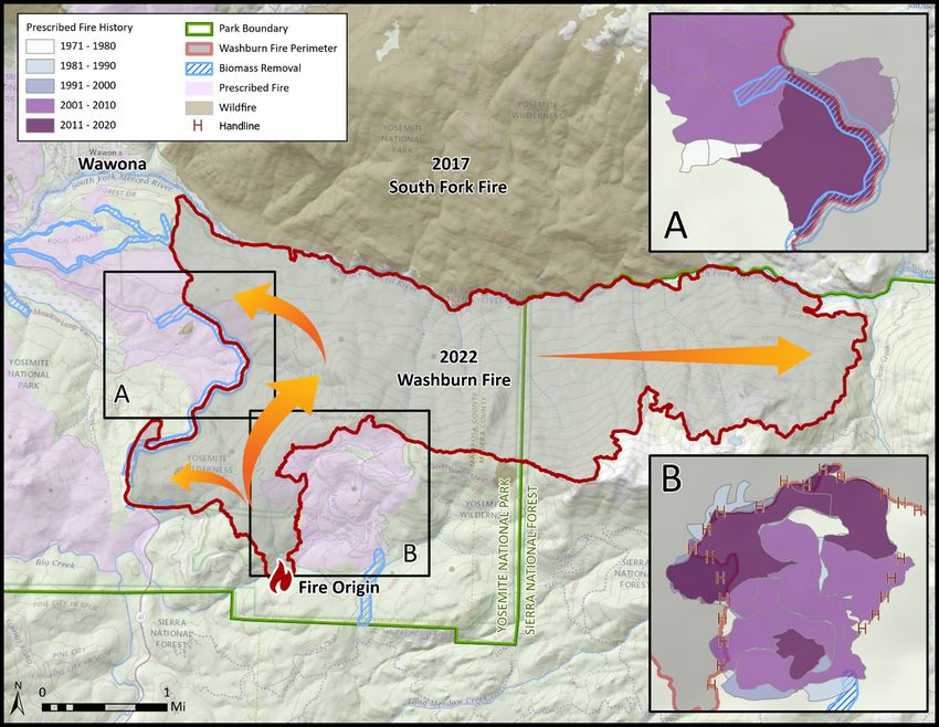
Abstract
Background
The Washburn fire started on July 7, 2022 in the lower Mariposa Grove in Yosemite National Park, posing
immediate threats to the iconic giant sequoias, critical Pacific fisher habitat, and the community of
Wawona and bringing national attention to Yosemite’s firefighting efforts. In the aftermath of the
Washburn, we evaluate how decades of fire management and recent roadside thinning in the Park
shaped the tactics and outcomes of the Washburn fire. Fuels reduction and prescribed fire have been at
the core of Yosemite’s fire management program since the 1970s and much of this activity has been
concentrated in the two areas where firefighting operations were most successful in protecting key
resources. We use long-term fire effects monitoring data, airborne light detection and ranging data, and
operational perspectives to link together science, management, and fire operations.

Results
Successful initial attack and suppression efforts kept fire out of the Mariposa Grove and the community,
where topography and the distribution of heavy fuels largely drove fire behavior throughout the course of
the fire. We demonstrate the cumulative effects of decades of fuels treatments in reducing two major
drivers of fire behavior – tree density and fuel load – and highlight substantially lower ladder fuels in
treatment units compared to the Washburn fire footprint.

Conclusions
We show how repeated prescribed fire and fuels treatments can promote forest structure indicative of
frequent-fire regimes, moderate extreme fire behavior, improve the ability to protect key resources of
concern, and increase human safety in the face of unplanned wildfire. Strategically placed prescribed fire
and fuels treatments surrounding the Washburn Fire were key considerations in wildfire suppression
tactics and were instrumental in protecting the Mariposa Grove.

Introduction
Hotter temperatures, prolonged drought and the abundance of dead and downed wood across the Sierra
Nevada have led to uncharacteristically large, intense wildfires in recent decades (McKelvey et al. 1996,
Hagmann et al. 2021). These fires displace and threaten communities and can exceed the resistance and
resilience mechanisms of wildlife and plant populations (e.g. Jones et al. 2021, Shive et al. 2022). During
the past five years, approximately 20 percent of the entire population of endemic mature giant sequoias
(Sequoiadendron giganteum) in the Sierra Nevada have been lost (Shive et al. 2022, Stephenson et al.
2021). A century of fire suppression in the Sierra Nevada has led to forest conditions with greater tree
densities, fuel loads, and proportion of shade-tolerant tree species than pre-settlement conditions (Collins
                                                  Page 2/21
et al. 2011, Knapp et al. 2013, Stephens et al. 2015). These forest conditions can increase rates and size
of high-severity fire (Steel et al. 2015, Stephens et al. 2015, Boisramé et al. 2017). Higher tree densities
have also been associated with reduced forest health (Hankin and Anderson 2022) and widespread bark
beetle-induced tree mortality (Fettig et al. 2007). Historical forest structure through frequent lightning
ignitions and Indigenous burning promoted ecosystem resilience by minimizing competition and resisting
high-severity wildfire (North et al. 2022). Active fuels management, primarily thinning and prescribed fire,
are effective tools to restore forest conditions that limit the spread of large, high-severity wildfires and
maintain natural ecosystem processes (Fulé et al. 2012, Restaino et al. 2019, North et al. 2021).
For forests with historically frequent fire (e.g. mixed-conifer, giant sequoia, ponderosa pine (Pinus
ponderosa)), reducing forest density through mechanical fuel treatments and prescribed fire can prevent
high-severity fire and restore natural ecosystem processes (Stephens et al. 2013). Fuel treatments and
previous burn footprints are effective barriers to the spread and probability of high-severity fire (Collins et
al. 2010, Lydersen et al. 2017, Cansler et al. 2022). Mechanical thinning treatments followed by
prescribed fire effectively reduce fireline intensities, the likelihood of passive and active crown fire, surface
fuel loads, and retain larger trees through increased stand resistance (Pollet and Omi 2002, Stephens and
Moghaddas 2005, Stephens et al. 2009, Fule et al. 2012). For example, the largest fire in Yosemite
National Park history, the 2013 Rim Fire, had significantly lower proportions of high-severity fire in areas
with previous fuels treatments or were burned by low- to moderate-severity fire (Lydersen et al. 2017),
limiting negative impacts of plume-dominated wildfire. These reductions in fire intensity increase human
safety and allow for more effective firefighting in the wildland-urban interface. Beyond moderating fire
behavior, restoration thinning and prescribed fire treatments provide numerous co-benefits (Stephens et
al. 2020). Associated increases in soil moisture have been shown to significantly increase dead woody
debris fuel moisture content and shorten fire seasons (Rakhmatulina et al. 2021). Furthermore,
treatments have been shown to enhance biodiversity, increase water availability, increase long-term
carbon storage stability (Krofcheck et al. 2017), and improve forest resilience to beetles, and drought
(Churchill et al. 2013, Young et al. 2017).
Like much of the Sierra Nevada, Yosemite’s mixed-conifer forests are dense with ladder fuels and dead
biomass after a century of fire suppression and the recent severe drought and bark beetle outbreaks.
These fuel conditions pose significant risks to the Park’s communities and numerous natural resources.
Strategically-placed prescribed fire and other fuels reduction treatments have been implemented in
Yosemite to achieve protection and resource objectives, particularly in the wildland-urban interface and
surrounding the Park’s giant sequoia groves. By reducing heavy fuel loads and removing abundant dead
biomass, the Park can create more resilient communities and landscapes to ongoing climatic change and
increasing fire activity. Prescribed fire is the primary tool for reducing fire risk, however, fuel conditions in
some areas of the Park require significant preparation prior to first-entry burning to meet objectives of
firefighter safety and ecological benefit. This need has increased with expanding drought- and bark
beetle-caused tree mortality. Thinning and brush removal are therefore important components to the fire
management program to allow for safe prescribed burning implementation. Recent roadside thinning
projects using mechanical biomass removal have greatly increased the Park’s capacity for prescribed
Page 3/21burn projects. Furthermore, reducing tree densities and surface fuel loads along roadways maintain safe
evacuation routes, increase firefighter safety by creating significant fuel breaks, and allow for
suppression tactics such as backfire operations. This proactive management strategy facilitates more
effective resource management and wildfire suppression in the face of longer fire seasons, hotter
temperatures and associated drought, and rapidly changing fuel conditions.
While research has demonstrated the effectiveness of fuels treatments such as thinning and prescribed
fire in moderating fire behavior and reducing the risk of large, catastrophic fire, there are few opportunities
to directly link historical and contemporary fuels treatments to unplanned wildfire operations and
outcomes. In July 2022, the Washburn Fire started in Yosemite National Park in a location immediately
threatening the Park’s largest giant sequoia grove, critical habitat for the threatened Pacific fisher
(Pekania pennanti), and the community of Wawona. It was also an area with a rich history of fuels
treatments and prescribed fire surrounding these highly valued natural resources, therefore the Washburn
Fire presented an opportunity to evaluate the direct impact of a long-term fire management program.
Here, we join together historical fuels treatments, recent biomass removal operations, and an unplanned
wildfire in Yosemite National Park to highlight how fuels treatments influenced decisions and tactics for
the Washburn fire - a wildfire with a full suppression response, and significantly impacted successful
protection of the Mariposa Grove of Giant Sequoias and the community of Wawona. First, we provide
background and data on the use of prescribed fire and thinning treatments in the areas surrounding the
Washburn Fire, second, we use airborne LiDAR data to highlight forest structure differences between
these treatment areas and the footprint of the Washburn fire, and third, we discuss how this treatment
history influenced the outcome of the Washburn Fire.
Methods
Study area
Yosemite National Park is located in the central Sierra Nevada of California and encompasses over
307,156 hectares, 94% of which is designated Wilderness. The Park extends from low-elevation dry
forests and chaparral to high-elevation subalpine forests and granitic peaks. The climate is
Mediterranean, with hot, dry summers and cold, snowy winters. Numerous natural and cultural resources
exist within the Park, including habitat for the threatened Pacific fisher, spotted owl (Strix occidentalis)
and Great gray owl (Strix nebulosa), and sensitive amphibians, giant sequoias, and abundant
archaeological sites. Fire has a strong influence on these Park resources and shapes the configuration
and composition of Yosemite’s forests. Lightning strikes are pervasive throughout the Park and ignite
numerous fires each year (Van Wagtendonk 1994, van Wagtendonk and Davis 2010). Both from lightning
and cultural burning, fire has historically occurred in all vegetation types in the Park (excluding the high-
elevation alpine zone), however fire was excluded from much of the Park from the late 19th to mid-20th
century. Consequently, early researchers in the Park identified an issue of abundant fuels and unnaturally
dense forests within Yosemite, posing risks to valued resources such as the Mariposa Grove of Giant
Sequoias, and nearby communities (Kilgore 1972, Biswell 1999, Van Wagtendonk 2007).
Page 4/21Managing natural lightning ignitions for multiple objectives and prescribed fire have been a part of the
fire management program since the early 1970s. In many areas, abundant high elevation granite, the lack
of access, and minimal threats to human infrastructure allow for fire management strategies such as
confine and contain or monitor with no direct suppression. Much of the forest remains departed from
natural fire return intervals, however, resulting in abundant fuels across the landscape (Scholl and Taylor
2010, NPS 2022). Management interventions are therefore necessary to reduce fire hazard and the threat
of large, catastrophic wildfire, protect life and property, and prevent negative ecological outcomes that
result from fire behavior outside of the natural range of variability.
The Mariposa Grove of Giant Sequoias is the largest sequoia grove within Yosemite National Park and is
home to over 500 mature giant sequoias. The Mariposa Grove holds significance for the origins of
natural land protection and the national park idea as the first natural area protected in perpetuity for its
scenic and recreational value, designated by President Lincoln in 1864. The Mariposa Grove has a rich
history of natural and prescribed fire, with fires dating back to 450 C.E. (Biswell 1961) and occurring
frequently (every 1–15 years, Swetnam et al. 1990). The Mariposa Grove was one of the first areas of
Yosemite to be treated as part of its prescribed fire program (Table 1) and remains a focal area for
Yosemite fire and fuels management. Over 1,821 hectares have been treated by prescribed fire in the
Mariposa Grove and surrounding areas near the community of Wawona since 1970, targeting small-
diameter shade-tolerant trees and heavy dead and downed fuels to promote healthy forest conditions and
giant sequoia regeneration (Kilgore 1972, Shive et al. 2018).
Page 5/21Table 1
Prescribed fire treatments in
the Mariposa Grove and
surrounding areas near the
community of Wawona.
Year Hectares Burned
1970 179
1971 30
1972 26
1973 36
1975 125
1979 16
1983 13
1984 80
1985 71
1989 30
1990 21
1991 5
1992 5
1993 28
1994 57
1995 11
1996 15
1997 85
1998 13
1999 66
2002 291
2003 290
2004 61
2005 57
2006 25
Page 6/21Year Hectares Burned
2008 53
2015 72
2016 42
2017 53
Fire and fuels management
As part of the Yosemite prescribed fire and fuels management program, fire effects monitoring data has
been collected surrounding treatment events in the Mariposa Grove and the community of Wawona since
1990. The fire effects monitoring program has followed protocols established by the National Park
Service Fire Monitoring Handbook (NPS 2003) and collects data such as forest structure and
composition, fuel load, and burn severity to track long-term treatment effects and facilitate adaptive
management. This decades-long record of forest conditions highlights important changes facilitated by
prescribed fire and demonstrates the effectiveness of these fuel treatments in achieving management
objectives such as fire hazard reduction and forest health.
We used long-term fire effects data maintained in the FEAT-FIREMON database from 15 plots in the
Mariposa Grove and 16 plots in the area surrounding Wawona. Some aspects of the sampling protocols
have been changed over the period of record, therefore, we selected tree density, basal area (i.e. cross-
sectional area of a tree), and fuel load as informative and consistent metrics of forest condition and
metrics frequently targeted by managers for treatment objectives. We used linear models to evaluate the
relationship between these metrics and time. All analyses were performed in R (R Core Team 2021).
We used high-density return airborne LiDAR to compare forest structure between the forests within the
Washburn fire footprint and those with a history of prescribed fire (i.e. Mariposa Grove and Wawona
area). LiDAR-derived data layers were produced for Yosemite National Park as part of the California
LiDAR project’s southwest pilot area in collaboration with the U.S. Geological Survey’s 3DEP program
(collected 10/07/2019–10/23/2019). LiDAR metrics were developed according to methods outlined in
Chamberlin et al. (2021), and here, we use post-processed canopy cover metrics and tree approximate
objects (“TAOs”, hereafter, “tree density”). TAOs may not represent true individual trees but rather include
one dominant tree as well as several subdominant trees due to detection of interlocking crowns during
the LiDAR point cloud segmentation process (Jeronimo et al. 2018). TAOs considered here represent both
live and dead canopy. We tested differences in canopy cover by each height stratum between the
Washburn fire and surrounding fuels treatment areas with t-tests (α = 0.05).
To assist in wildfire preparedness and facilitate protection of human life, property, and natural and
cultural resources, Yosemite has implemented roadside biomass removal along its major road corridors
in 2021 and 2022. The roadside biomass removal projects aim to reduce horizontal and vertical fuel
continuity within 61 meters (200 feet) of roads to strengthen important fuel breaks and moderate fire
Page 7/21behavior along roads, thus increasing firefighter safety and facilitating safer evacuation procedures
should a wildfire occur (Fig. 1). These projects mechanically remove trees up to 0.51 meters in diameter
and hazard trees killed by fire, insects, and drought. The biomass removal projects have treated 185 ha
and removed approximately 4851 metric tons of fuel since its start in 2020.
Washburn Fire
We conducted informal interviews with fire operations personnel on the Washburn Fire and consulted
published decisions from the Wildland Fire Decision Support System (WFDSS) to evaluate protection
priorities, values at risk, tactical and strategic decisions, and expected fire behavior. WFDSS decisions
were published weekly during the incident and address considerations for incident management, such as
weather, fire behavior, natural and cultural resource and socioeconomic values, and resource availability
for suppression tactics.
Results
Fire and fuels management
We found that in the Mariposa Grove, live tree density (> 10 cm diameter at breast height) and basal area
per hectare decreased over three decades of prescribed fire treatments (Fig. 2), although these trends
were not statistically significant (p > 0.05, Table 2). Live tree density in the Wawona area similarly
decreased significantly over time (p = 0.01), yet basal area per acre remained constant over the same
treatment history (p = 0.83). This difference likely indicates that prescribed fire treatments targeted
removal of small trees in the Wawona area, as they do not contribute significantly to basal area.
Conversely in the Mariposa Grove, larger understory tree removal, as well as infrequent, stochastic loss of
giant sequoias from wind events likely explain the larger decline in basal area over time. Prescribed fire
treatments were effective at reducing fine woody debris over shorter timescales, where recovery of pre-
treatment fuel loads occurs within five years of a treatment (Fig. 3).
Page 8/21Table 2
Model results from linear models predicting live tree density (per
hectare) and basal area (square meters per hectare) as a function of
year. Individual models were specified for data from the Mariposa
grove and Wawona.
Model Slope t-value p-value R-squared
Mariposa Grove
Live tree density ~ Year -28.34 -1.64 0.12 0.11
Basal area ~ Year -0.52 -1.87 0.08 0.14
Wawona
Live tree density ~ Year -87.59 -3.06 0.01 0.46
Basal area ~ Year -0.05 -0.22 0.83 0.00
LiDAR-derived canopy cover data indicate that the untreated Washburn fire footprint and surrounding
treated areas did not differ significantly in overstory tree cover or surface cover (p > 0.05), but canopy
cover from 2 to 16 meters in height (i.e. ladder fuels) were significantly different between the two areas (p
< 0.05 for each height stratum, Fig. 4). Ladder fuels were substantially lower in the treated areas, where
decades of fuels treatments have been implemented. In contrast, the majority of the Washburn Fire
footprint had no recent fire history, and thus substantially denser forest conditions. Lidar-derived tree
density was also much higher within the Washburn footprint, with 135 mean trees per hectare compared
to 104 and 99 mean trees per hectare in the treated Mariposa Grove and the Wawona area, respectively.
The Washburn Fire
The Washburn Fire started on July 7, 2022, in the lower Mariposa Grove in Yosemite National Park (Fig. 5)
posing immediate threats to the iconic giant sequoias and the community of Wawona. The fire quickly
gained national attention. Successful initial attack and suppression efforts kept fire out of the Mariposa
Grove and the community of Wawona, but the surrounding topography and distribution of heavy fuels
drove intense fire behavior and rapid fire spread. Regional fire activity was low, therefore, abundant
resources were available for suppression efforts. A Type II Incident Management Team transitioned onto
the Washburn Fire on July 9th. In the first two days, the Washburn Fire grew to 737 hectares and
increased to 1846 hectares by July 14th. There was limited fire spread throughout the next two weeks,
with total fire size reported as 1977 hectares.
Numerous values were at risk as the Washburn Fire progressed. The fire started at the southwest corner
of the Mariposa Grove, where it could move uphill rapidly into the grove and threaten its hundreds of
mature trees. The Grove is also home to numerous wildlife species, the Galen Clark historical cabin, and
significant cultural sites. The Washburn Fire burned entirely within critical habitat for the threatened
Pacific fisher. Furthermore, dense and steep forested terrain stood between the Mariposa Grove and the
Page 9/21community of Wawona, prompting evacuations of employees and private residents. Power and
communications infrastructure were in close proximity to the fire.
The Washburn Fire burned rapidly through steep terrain without any known fire history, characterized by
abundant dead and downed fuels and dense ladder fuels. These forest conditions are the legacy of
almost a century of fire suppression, and the horizontal and vertical fuel continuity facilitated rapid fire
spread, intense fire behavior, and high resistance to control. Furthermore, conditions were already hot and
dry relatively early in the fire season, with Energy Release Components ranging (ERC) from the 90th to
97th percentile in the first two weeks of July. The combination of abundant fuels and conducive weather
(approx. 30°C at 1524 m elevation, 19–31% humidity) led to a few days of explosive fire growth and
continued active burning overnight with little humidity recovery.
Discussion
In an era of “mass fires” (Stephens et al. 2022), where devastating impacts of wildfire to human
communities, infrastructure, and biological populations are increasingly commonplace (e.g. 2018 Camp
Fire, 2021 Dixie Fire, 2021 KNP Complex), strategic and proactive management actions are critical in
preventing catastrophic wildfire and facilitating beneficial fire effects. The 2022 Washburn Fire
immediately threatened some of Yosemite’s most valued resources – the Mariposa Grove of giant
sequoias, critical habitat for Pacific fisher, and the community of Wawona, home to many Park
employees and private citizens. Despite these threats, no mature giant sequoias and no structures were
lost. Areas of the grove that remained unburned also provided refugia for Pacific fishers both during and
after the Washburn Fire, including one being monitored by the Park with a GPS collar. Without the rich
history of fuels reduction and prescribed fire in and surrounding these highly valued resources, this
wildfire could have had a very different outcome for these irreplaceable communities.
Historical and contemporary fuels reduction treatments through prescribed fire and mechanical biomass
removal played a substantial role in protecting important values within the Park during the Washburn
Fire. Through long-term monitoring data and contemporary observations, we highlight how these fuels
management actions effectively limited horizontal and vertical fuel continuity, moderating fire behavior
and providing important anchor points for suppression tactics during the Washburn Fire. Prescribed fire
alone typically does not significantly change overstory conditions (Stephens et al. 2012), but the
reduction of surface and ladder fuels (Figs. 3–4) through repeated small prescribed fires over decades
achieved conditions associated with forest resilience. These data highlight the need for continued and
frequent, repeated treatments to maintain lower fuel loads, prevent encroachment of abundant shade-
tolerant tree species, and continue to act as effective barriers to fire spread. Reduced tree densities and
surface fuels were important considerations in suppression tactics and resource prioritization when the
Washburn Fire started.
Wildfire response
Page 10/21Incident management identified recent fuels treatments and existing roads as primary holding features to
accomplish holding objectives following initial attack of the Washburn Fire. Objectives included keeping
the fire to as small a footprint as possible and limiting fire spread towards the community of Wawona,
Wawona Road, Yosemite’s southern entrance station, the Mariposa Grove, and the administrative
boundary with Sierra National Forest. While abundant dry fuels largely drove fire progression, reduced
fuel continuity in the Mariposa Grove moderated fire behavior and allowed for fewer resources in those
areas and safer firefighter entry. Handline construction from the lower grove to Wawona Point was fast
and effective, requiring only two shifts of two to three hotshot crews (pers. comm. Parker Bevington).
These suppression tactics were effective at minimizing threats to the mature sequoias, requiring
additional individual tree protection primarily in trees with pre-existing fire scars. Fire-scarred trees are
particularly vulnerable to subsequent fire damage, as exposed wood and thinner bark can lead to greater
cambium damage (Shive et al. 2022). Only one handline from the grove was abandoned due to increases
in fire activity the second day of the fire. As crews were initially trying to hold the fire west of the grove,
conditions worsened and made it clear that holding in that location would be impossible given heavy fuel
loads outside of the grove.
“It became clear that holding the fire on the edge of the grove was going to be the best chance since it's
been burned so many times and would need less resource commitment in lighter fuels.” – Parker
Bevington, Duty Officer for Yosemite and Division Supervisor on the Washburn Fire
The biomass thinning projects along Wawona Road also facilitated quick and effective holding
operations with limited resources. Fire within the thinning zone backed slowly down towards the road and
fire crews were able to safely implement low to moderate intensity backing fires down towards the road
as needed (Fig. 1). Local incident management personnel stated that “without the debris removal already
completed [along Wawona Road], I do not believe we would have been able to keep fire from crossing the
road.” By requiring fewer firefighters in the grove and along Wawona Road (due to biomass thinning
projects), additional firefighters could be committed to structure protection in Wawona and handline
construction in heavily fuel-loaded areas that were important for holding (pers. comm. Parker Bevington).
It is important to note that the Washburn Fire is not without short-term and long-term ecological impacts.
Essential wildfire suppression actions, such as dozer lines and aerial retardant applications, can
temporarily or permanently reduce Wilderness character and directly impact rare plants. Rare plants and
sensitive wildlife species are also directly and indirectly impacted by flame, heat, and noise associated
with firefighting operations. Within the dense interior of the fire footprint, large patches of high-severity
fire significantly impacted forest communities, removing large contiguous swaths of Pacific fisher habitat
and killing numerous mature sugar pines. While these areas may recover to pre-fire vegetation
composition and configuration, climatic extremes and seed limitations may direct areas towards
alternate post-fire recovery trajectories (Welch et al. 2016, Shive et al. 2018).
The Washburn Fire is a valuable demonstration of how fuels treatments are incorporated into wildfire
suppression tactics to accomplish incident objectives. Existing fuel treatments greatly increase the ability
Page 11/21of firefighting resources to access and successfully implement firefighting tactics under intense fire
behavior. Notably, the Washburn did not burn under the most extreme fire weather conditions and we
would expect that fuel treatments alone are less effective under extreme fire weather (Safford et al.
2012). However, over 77% of fire starts in this area of the Park occurred below the 80th percentile in
energy release component in the last five years (NPS Data), highlighting that treating small areas
surrounding highly valued resources (Stephens et al. 2016) and strategically placed fuel breaks can be
effective barriers in the face of unplanned wildfire (Tubbesing et al 2019).
The distribution and magnitude of heavy fuels across the Sierra Nevada will require extensive fuels
reduction treatments to prevent the spread of catastrophic fire and ultimately, protect anthropogenic and
ecological communities. Managers have several tools available to accomplish these objectives
(prescribed fire, thinning, managed wildfire), however the problem remains greater than the capacity of
individual fire management programs, particularly in the face of prolonged wildfire seasons. Ongoing
efforts to prioritize fuel treatments based on resource values and risk assessments coupled with
evaluating the effectiveness of these treatments when disturbances occur will inform the widest impact
in accomplishing protection and resource management goals.
Declarations
Ethics approval and consent to participate
Not applicable
Consent for publication
The authors have consent to publish.
Availability of data and material
Yosemite fire effects data are publicly available on the National Park Service’s Data Store (DataStore -
Generic Dataset - (Code: 2239371) (nps.gov)) and LIDAR is available through the USGS 3DEP program at:
LidarExplorer (prd-tnm.s3.amazonaws.com).
Competing interests
The authors declare that they have no competing interests.
Funding
This research was conducted without additional funding support.
Authors' contributions
Page 12/21S.L.S. and G.D. conceptualization, L.H. analysis and writing, P.B. interview, S.L.S., G.D., L.H. C.A. P.B.
review and editing
Acknowledgements
We thank and miss Jan van Wagtendonk for his innumerable contributions to research and management
in Yosemite National Park. Jan was one of the people whose leadership began the fuels reduction
program in the Mariposa Grove that helped saved the grove. His legacy of science-informed fire and fuels
management continues to guide protection and resource management today.
Thank you to Jennifer Anderson for thoughtful feedback and data assistance. We also express our
gratitude to the University of Washington Forest Resilience Lab for LiDAR processing.
References
1. Biswell, H. 1961. National Park Service Archives.
2. Biswell, H. 1999. Prescribed burning in California wildlands vegetation management. Univ of
California Press.
3. Boisramé, G., S. Thompson, B. Collins, and S. Stephens. 2017. Managed Wildfire Effects on Forest
Resilience and Water in the Sierra Nevada. Ecosystems 20, 717–732, doi:10.1007/s10021-016-0048-
1.
4. Cansler, C. A., V. R. Kane, B. N. Bartl-Geller, D. J. Churchill, P. F. Hessburg, N. A. Povak, J. A. Lutz, J.
Kane, and A. J. Larson. 2022. Postfire Treatments Alter Forest Canopy Structure up to Three Decades
after Fire. Forest Ecology and Management 505: 119872. doi:10.1016/j.foreco.2021.119872.
5. Chamberlin, C. P., A. J. Sánchez, Meador, and A. E. Thode. 2021. Airborne lidar provides reliable
estimates of canopy base height and canopy bulk density in southwestern ponderosa pine forests.
Forest Ecology and Management 481: 118695.
6. Churchill, D. J., A. J. Larson, M. C. Dahlgreen, J. F. Franklin, P. F. Hessburg, and J. A. Lutz. 2013.
Restoring forest resilience: from reference spatial patterns to silvicultural prescriptions and
monitoring. Forest Ecology and Management 291: 442–457.
7. Collins, B. M., S. L. Stephens, J. J. Moghaddas, and J. Battles. 2010. Challenges and approaches in
planning fuel treatments across fire-excluded forested landscapes. J For 1081: 24–31, 40, 1751–
1765.
8. Collins, B. M., R. G. Everett, and S. L. Stephens. 2011. Impacts of Fire Exclusion and Recent Managed
Fire on Forest Structure in Old Growth Sierra Nevada Mixed-Conifer Forests. Ecosphere 2, art51,
doi:10.1890/ES11-00026.1.
9. Fettig, C. J., K. D. Klepzig, R. F. Billings, A. S. Munson, T. E. Nebeker, J. Negron, and J. T. Nowak. 2007.
The effectiveness of vegetation management practices for prevention and control of bark beetle
infestations in coniferous forests of the western and southern United States. Forest Ecology and
Management 238 (1–3): 24–53.
Page 13/2110. Fulé, P. Z., J. E. Crouse, J. P. Roccaforte, and E. L. Kalies. 2012. Do Thinning and/or Burning
Treatments in Western USA Ponderosa or Jeffrey Pine-Dominated Forests Help Restore Natural Fire
Behavior? Forest Ecology and Management 269: 68–81. doi:10.1016/j.foreco.2011.12.025.
11. Hagmann, R. K., P. F. Hessburg, S. J. Prichard, N. A. Povak, P. M. Brown, P. Z. Fulé, R. E. Keane, E. E.
Knapp, J. M. Lydersen, K. L. Metlen, M. J. Reilly, A. J. Sánchez Meador, S. L. Stephens, J. T. Stevens,
A. H. Taylor, L. L. Yocom, M. A. Battaglia, D. J. Churchill, L. D. Daniels, D. A. Falk, P. Henson, J. D.
Johnston, M. A. Krawchuk, C. R. Levine, G. W. Meigs, A. G. Merschel, M. P. North, H. D. Safford, T. W.
Swetnam, and A. E. M. Waltz. 2021. Evidence for widespread changes in the structure, composition,
and fire regimes of western North American forests. Ecological Applications 31(8): e02431.
12. Jeronimo, S. M. A., V. R. Kane, D. J. Churchill, R. J. McGaughey, and J. F. Franklin. 2018. Applying
LiDAR Individual Tree Detection to Management of Structurally Diverse Forest Landscapes. Journal
of Forestry 116: 336–346. doi:10.1093/jofore/fvy023.
13. Jones, G. M., A. R. Keyser, A. L. Westerling, W. J. Baldwin, J. J. Keane, S. C. Sawyer, J. D. Clare, R.
Gutiérrez, and M. Z. Peery. 2021. Forest Restoration Limits Megafires and Supports Species
Conservation under Climate Change. Frontiers in Ecol & Environ 20: 210–216. doi:10.1002/fee.2450.
14. Kilgore, B. M. 1972. The Role of Fire in a Giant Sequoia-Mixed Conifer Forest. Research in the Parks:
Transactions of the National Park Centennial Symposium, Annual Meeting of the American
Association for the Advancement of Science. U.S. Department of the Interior.
15. Knapp, E. E., C. N. Skinner, M. P. North, and B. L. Estes. 2013. Long-term overstory and understory
change following logging and fire exclusion in a Sierra Nevada mixed-conifer forest. Forest Ecology
and Management 310: 903–914.
16. Krofcheck, D. J., M. D. Hurteau, R. M. Scheller, and E. L. Loudermilk. 2018. Prioritizing forest fuels
treatments based on the probability of high-severity fire restores adaptive capacity in Sierran forests.
Glob Chang Biol 24 (2): 729–737. doi:10.1111/gcb.13913.
17. Lydersen, J. M., B. M. Collins, M. L. Brooks, J. R. Matchett, K. L. Shive, N. A. Povak, V. R. Kane, and D.
F. Smith. 2017. Evidence of fuels management and fire weather influencing fire severity in an extreme
fire event. Ecological Applications 27 (7): 2013–2030.
18. McKelvey, K. S., C. N. Skinner, C. Chang, D. C. Et-man, S. J. Husari, D. J. Parsons, J. W. van
Wagtenonk, and C. P. Weatherspoon. 1996. An Overview of Fire in the Sierra Nevada. Sierra Nevada
Ecosystem Project: Final report to Congress, vol II. University of California Davis: Davis, CA.
19. North, M., R. York, B. Collins, M. Hurteau, G. Jones, E. Knapp, H. Kobziar, H. McCann, M. Meyer, and S.
Stephens. 2021. Pyrosilviculture Needed for Landscape Resilience of Dry Western United States
Forests. J For 119: 520–544.
20. North, M. P., R. E. Tompkins, A. A. Bernal, B. M. Collins, S. L. Stephens, and R. A. York. 2022.
Operational resilience in western US frequent-fire forests. Forest Ecology and Management 519:
120004.
21. NPS [National Park Service]. 2022. Fire Return Interval Departure GIS Data. Yosemite National Park,
El Portal, CA. https://irma.nps.gov.
Page 14/2122. Pollet, J., and P. N. Omi. 2002. Effect of thinning and prescribed burning on crown fire severity in
ponderosa pine forests. International Journal of Wildland Fire 11 (1): 1–10.
23. Core Team, R. 2021. R: A language and environment for statistical computing. Vienna, Austria: R
Foundation for Statistical Computing.
24. Rakhmatulina, E., S. L. Stephens, and S. E. Thompson. 2021. Soil moisture influences on Sierra
Nevada dead fuel moisture content and fire risks. Forest Ecology and Management 496: 119379.
25. Restaino, C., D. J. N. Young, B. Estes, S. Gross, A. Wuenschel, M. Meyer, and H. Safford. 2019. Forest
structure and climate mediate drought-induced tree mortality in forests of the Sierra Nevada, USA.
Ecological Applications 29 (4): 1–14.
26. Safford, H. D., J. T. Stevens, K. Merriam, M. D. Meyer, and A. M. Latimer. 2012. Fuel treatment
effectiveness in California yellow pine and mixed conifer forests. Forest Ecology And Management
274: 17–28. https://doi.org/10.1016/j.foreco.2012.02.013.
27. Scholl, A. E., and A. H. Taylor. 2010. Fire regimes, forest change, and self-organization in an old-
growth mixed-conifer forest, Yosemite National Park, USA. Ecological Applications 20 (2): 362–380.
28. Shive, K. L., H. K. Preisler, K. R. Welch, H. D. Safford, R. J. Butz, K. O’Hara, and S. L. Stephens. 2018.
From the stand-scale to the landscape-scale: predicting the spatial patterns of forest regeneration
after disturbance. Ecological Applications 28 (6): 1626–1639. https://doi.org/10.1002/eap.1756.
29. Shive, K. L., A. Wuenschel, L. J. Hardlund, S. Morris, M. D. Meyer, and S. M. Hood. 2022. Ancient trees
and modern wildfires: Declining resilience to wildfire in the highly fire-adapted giant sequoia. Forest
Ecology and Management, 511, p.120110.
30. Steel, Z. L., H. D. Safford, and J. H. Viers. 2015. The fire frequency-severity relationship and the
legacy of fire suppression in California forests. Ecosphere 6 (1): 8. http://dx.doi.org/10.1890/ES14-
00224.1.
31. Stephens, S. L., J. J. Moghaddas, C. Edminster, C. E. Fiedler, S. Hasse, M. Harrington, J. E. Keeley, E. E.
Knapp, J. D. McIver, K. Metlen, C. N. Skinner, and A. Youngblood. 2009. Fire treatment effects on
vegetation structure, fuels, and potential fire severity in western U.S. forests. Ecological Applications
19 (2): 305–320.
32. Stephens, S. L., B. M. Collins, and G. Roller. 2012. Fuel treatment longevity in a Sierra Nevada mixed
conifer forest. Forest Ecology and Management 285: 204–212.
33. Stephens, S. L., J. K. Agee, P. Z. Fulé, M. P. North, W. H. Romme, T. W. Swetnam, and M. G. Turner.
2013. Managing forests and fire in changing climates. Science 342 (6154): 41–42.
34. Stephens, S. L., J. M. Lydersen, B. M. Collins, D. L. Fry, and M. D. Meyer. 2015. Historical and Current
Landscape-Scale Ponderosa Pine and Mixed Conifer Forest Structure in the Southern Sierra Nevada.
Ecosphere 6, art79, doi:10.1890/ES14-00379.1.
35. Stephens, S. L., B. M. Collins, E. Biber, and P. Z. Fulé. 2016. U.S. federal fire and forest policy:
emphasizing resilience in dry forests. Ecosphere 7 (11): e01584.
36. Stephens, S. L., A. L. Westerling, M. D. Hurteau, M. Z. Peery, C. A. Schultz, and S. Thompson. 2020.
Fire and climate change: conserving seasonally dry forests is still possible. Frontiers in Ecology and
Page 15/21the Environment 18 (16): 354–360.
37. Stephens, S. L., A. A. Bernal, B. M. Collins, M. A. Finney, C. Lautenberger, and D. Saah. 2022. Mass fire
behavior created by extensive tree mortality and high tree density not predicted by operational fire
behavior models in the southern Sierra Nevada. 518. 120258. Forest Ecology and Management.
38. Stephenson, N., C. Brigham, S. Cag, C. A. Caprio, J. Flickinger, L. Hardlund, R. Hart, P. Hardwick, L.
Mutch, S. N. Inventory, and K. Shive. 2021. Preliminary estimates of sequoia mortality in the 2020
Castle Fire.
39. Swetnam, T. W., R. Touchan, C. H. Baisan, A. C. Caprio, and P. Brown. 1990. Giant sequoia fire history
in Mariposa Grove, Yosemite National Park. Yosemite Centennial Symposium Proceedings, Natural
Areas and Yosemite: Prospects for the Future..
40. Tubbesing, C. L., D. L. Fry, G. B. Roller, B. M. Collins, V. A. Fedorova, S. L. Stephens, and J. J. Battles.
2019. Strategically placed landscape fuel treatments decrease fire severity and promote recovery in
the northern Sierra Nevada. UC Berkeley. http://dx.doi.org/10.1016/j.foreco.2019.01.010.
41. USDI National Park Service. 2003. Fire Monitoring Handbook. Fire Management Program Center,
National Interagency Fire Center, Boise, ID. 274 p.
42. Van Wagtenkdonk. 1994. Spatial patterns of lightning strikes and fires in Yosemite National Park.
Proceedings of the 12th conference on fire and forest meteorology.12 223–231.
43. Van Wagtendonk, J. W. 2007. The history and evolution of wildland fire use. Fire Ecology 3 (2): 3–17.
44. van Wagtendonk, K. A., and B. H. Davis. 2010. Revisiting spatial patterns of lightning strikes and fires
in Yosemite National Park. In Rethinking protected areas in a changing world: Proceedings of the
2009 George Wright Society biennial conference on parks, protected areas, and cultural sites
(pp. 125–130).
45. Welch, K. R., H. D. Safford, and T. P. Young. 2016. Predicting conifer establishment post wildfire in
mixed conifer forests of the North American Mediterranean-climate zone. Ecosphere 7 (12).
https://doi.org/10.1002/ecs2.1609.
46. Young, D. J. N., J. T. Stevens, J. M. Earles, J. Moore, A. Ellis, A. L. Jirka, A. M. Latimer, and F. Lloret.
2017. Long-term climate and competition explain forest mortality patterns under extreme drought.
Ecology Letters 20 (1): 78–86. https://doi.org/10.1111/ele.12711.
Figures
Page 16/21Figure 1
Repeat photo points along Wawona Road, before (A) and after (B) roadside biomass thinning. (C) Low
intensity surface fire during the Washburn Fire, providing safe access for firefighters. (D) Low severity fire
effects (i.e. low tree mortality) after the fire has moved through.
Page 17/21Figure 2
Live trees per hectare (a, c) and basal area (cross-sectional area of a tree, in square meters) per hectare (b,
d) over time in Mariposa grove (a, b) and the Wawona area (c, d), where decades of fuels and fire
management (primarily prescribed fire) have occurred. Larger trees contribute more basal area, thus the
Wawona area highlights the focus on removal of small-diameter trees. Data are from long-term
monitoring plots as part of the Yosemite fire effects monitoring program.
Page 18/21Figure 3
1-hr (a, c) and 100-hr (b, d) fuel loads (metric tons/hectare) over time relative to treatment implementation
in Mariposa Grove (a, b) and Wawona area (c, d), respectively, where decades of fuels and fire
management (primarily prescribed fire) have occurred. The Mariposa Grove, in particular, highlights the
timeline for fuels recovery following treatment, and approach pre-treatment levels in five years. Data are
from long-term monitoring plots as part of the Yosemite fire effects monitoring program.
Page 19/21Figure 4
Lidar-derived canopy cover in different height strata in untreated forests within the Washburn Fire
perimeter and treated forests just outside of the perimeter in the Mariposa Grove and Wawona treatment
areas. This figure highlights the abundance of mid-canopy fuels (i.e. ladder fuels) in the forests burned in
the Washburn compared to treated areas surrounding it, where decades of fuels management has
reduced fuels.
Page 20/21Figure 5
Washburn Fire perimeter with origin and arrows showing fire progression. Purple graduated shading
shows prescribed fire history in the Wawona area (inset A) and Mariposa Grove (inset B). The fire was
also bounded by the 2017 South Fork wildfire along its north perimeter and historical prescribed fires
along the western perimeter.
Page 21/21You can also read