Historical tsunamis of Taiwan in the 18th century: the 1781 Jiateng Harbor flooding and 1782 tsunami event
←
→
Page content transcription
If your browser does not render page correctly, please read the page content below

Nat. Hazards Earth Syst. Sci., 22, 2517–2530, 2022
https://doi.org/10.5194/nhess-22-2517-2022
© Author(s) 2022. This work is distributed under
the Creative Commons Attribution 4.0 License.

Historical tsunamis of Taiwan in the 18th century: the 1781 Jiateng
Harbor flooding and 1782 tsunami event
Tien-Chi Liu1,2 , Tso-Ren Wu3,4,5 , and Shu-Kun Hsu6,7
1 Center  for Astronautical Physics and Engineering, National Central University, Taoyuan, Taiwan
2 Department    of Space Science and Engineering, National Central University, Taoyuan, Taiwan
3 Graduate Institute of Hydrological and Oceanic Sciences, National Central University, Taoyuan, Taiwan
4 Department of Civil Engineering, National Central University, Taoyuan, Taiwan
5 Earthquake-Disaster & Risk Evaluation and Management Center, National Central University, Taoyuan, Taiwan
6 Department of Earth Sciences, National Central University, Taoyuan, Taiwan
7 Institute of Earth Sciences, Academia Sinica, Taipei, Taiwan

Correspondence: Tso-Ren Wu (tsoren@ncu.edu.tw)

Received: 16 November 2021 – Discussion started: 17 November 2021
Revised: 18 May 2022 – Accepted: 28 June 2022 – Published: 5 August 2022

Abstract. This research aims to study two historical               1   Introduction
tsunamis that occurred in Taiwan during the 18th century and
to reconstruct the incidents. The 1781 Jiateng Harbor flood-
ing, recorded by the Chinese historical document entitled          One of the major hazards in coastal regions is inundation
“Taiwan Interview Catalogue” took place on the southwest           by water waves generated by different mechanisms such
coast of Taiwan. In contrast, the 1782 tsunami was docu-           as storm surges, tsunamis, or meteotsunamis. Storm surges
mented in foreign languages, with uncertainties about the ac-      and meteotsunamis are known to be triggered by weather
tual time. These two events seem to be close enough in time        events associated with pressure changes. On the other hand,
and location that, to some researchers, they are considered as     tsunamis could be generated by earthquakes below or near
the same event. Reasoning these historical events requires         the ocean, submarine landslides, volcanic eruptions, mete-
carefully examining the literature records and performing          orite impacts, or off-shore rock falls, causing damage to the
the scenarios that match the descriptions. The impact inten-       infrastructure and large loss of life in the coastal areas (Gho-
sity analysis (IIA) is employed to locate possible regions of      barah et al., 2006; Mori et al., 2013; Widiyanto et al., 2019).
tsunami sources in order to reproduce the events. Numer-           On 15 January 2022, the volcanic eruption of Hunga Tonga–
ical simulations based on the Cornell Multi-grid Coupled           Hunga Ha’apai generated tsunami waves that triggered evac-
Tsunami Model (COMCOT) analyze the influence of dif-               uations in the surrounding countries. The sea-surface fluc-
ferent types of tsunamis generated by both submarine mass          tuations were widely recorded and raised worldwide atten-
failures and seismic activities. Numerical results indicate that   tion on the issue of coastal inundations (Carvajal et al.,2022;
the source of the 1781 Jiateng Harbor flooding is located very     Manneela and Kumar, 2022; Ramírez-Herrera et al., 2022).
possibly on the south-southwestern side of Taiwan. However,        To prepare for possible natural disasters in Macau, Li et
simulation results and historical records put the existence of     al. (2018) have assessed the future tsunami hazard evolving
the 1782 tsunami in doubt, and the possibility of storm surges     with a rising sea level. Potential tsunami hazard assessments
could not be ruled out.                                            in the South China Sea (SCS) have also been extensively
                                                                   studied over recent years (Li et al., 2016; Liu et al., 2009;
                                                                   Megawati et al., 2009; Okal et al., 2011). However, it is still
                                                                   essential to look back and examine the historical events in
                                                                   order to recognize the regions that could be affected again.
                                                                   In fact, although most historical tsunamis were reviewed al-

Published by Copernicus Publications on behalf of the European Geosciences Union.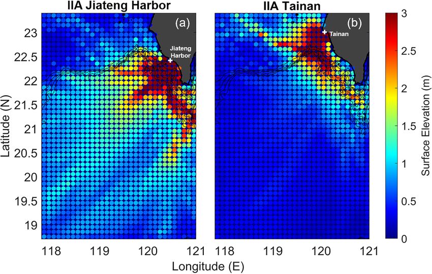
2518                T.-C. Liu et al.: Historical tsunamis of Taiwan in the 18th century: the 1781 Jiateng Harbor flooding

ready (Lau et al., 2010; Terry et al., 2017), some of the events   Lin, 2006). Lin (2006) suspected the 1781 flooding event
in Taiwan remain unknown.                                          as a typographical error of the 1721 tsunami event, which
   Located in the typhoon-prone area and the Circum-Pacific        also occurred on the southwest coast of Taiwan and affected
Belt, Taiwan suffers from both low-pressure weather systems        Tainan. Meanwhile, Lin (2006) regarded the 1782 tsunami
and seismic activities. As the historical storm surge events       documented in Russian as another typographical error of the
have been studied (Huang et al., 2007; Tsai, 2014), histor-        1867 Keelung tsunami by evaluating the credibility of the
ical tsunami events have also been modeled (Ma and Lee,            historical records. Li et al. (2015), on the other hand, elim-
1997; Okal et al., 2011), particularly for the 1867 Keelung        inated the seismic movements for the lack of historical re-
event, which is the only historical tsunami incident officially    ports in the neighboring countries and concluded that the
recognized by the government (Cheng et al., 2016; Chung,           severe tsunami of 1781/1782 was most likely generated by
2018; Lee, 2014). The 1781 Jiateng Harbor flooding and             submarine mass failures (SMFs). However, assuming that the
1782 tsunami event have received attention as well (Li et al.,     1781 Jiateng Harbor flooding and the 1782 tsunami were in-
2015; Mak and Chan, 2007; Okal et al., 2011). Nevertheless,        dependent incidents, we found that Gazette de France (1783)
these two incidents which seem close in time and location          and the German report of Jäger (1784) should also be listed
stay mysterious with unfounded tsunami sources (Fig. 1).           as the first and important sources of information about the
   Customs and local news of Taiwan during the Qing dy-            1782 tsunami event (see Sect. A1 and A2). First of all, the
nasty were recorded in the “Taiwan Interview Catalogue”            publication date of Gazette de France (1783) is the closest
(Chen, 1830). The Chinese historical document indicates a          to the event’s year. Second, from the words “Voici ce que
destructive flooding event occurred at Jiateng Harbor, sub-        je lis dans J. L. Ab Indagine L. M.” (i.e., “Here’s what I
merging the villages located in southwest Taiwan in 1781           read from J. L. Ab Indagine L. M.”) in Perrey (1862), it is
(See Text S1 from Li et al., 2015). At that time, the weather      reasonable to believe that most of the content in the docu-
was fine. Hence, it is less likely to be storm surges or meteo-    ment is quoted from the German report “Philosophisch und
rological tsunamis. However, the phenomena described in the        physikalische Abhandlungen” (Jäger, 1784). After examin-
historical report match well with typical features that usually    ing these two documents, it is also suspected that the date
appear in tsunami events (the sea roared like thunder, giant       of a second letter sent from Beijing to Versailles was re-
wave appeared, water retreated quickly, leaping fishes and         ported with a typographical error about the year. Indeed, the
shrimps left on the ground). Therefore, the 1781 Jiateng Har-      date “En décembre 1682” is found in Perrey’s (1862) record,
bor flooding has been viewed and formally listed as a histori-     while the phrase is “Im Decemb. Des 1782” in Jäger’s (1784)
cal tsunami in previous research (Hsu, 2007; Lau et al., 2010;     report, making the former less reliable.
Li et al., 2015; Lin, 2006; Mak and Chan, 2007; Yu, 1994).            Severe coastal impacts caused by storm surges have been
   Since there were no local earthquake movements recorded         recorded and studied. The Bay of Bengal was struck by
in the historical report of the 1781 Jiateng Harbor flooding,      Bhola cyclone in 1970, and more than 250 000 human lives
Yu (1994) considered a long-distance earthquake as a possi-        were taken away as a result of the storm surge and the flood-
ble source of the tsunami. Nevertheless, none of the historical    ing it triggered (Hossain et al., 2008). In 2005, the storm
earthquakes (Ganse and Nelson, 1982) could be found to fit         surge associated with Hurricane Katrina damaged tremen-
the location and the time of the 1781 Jiateng Harbor flooding.     dously the Gulf of Mexico, peaking at over 7 m along the
Note that tsunamis might be generated by other far-field ac-       Mississippi coastline (Fritz et al., 2007; Robertson et al.,
tivities, such as submarine volcanic eruptions. Omori (1916)       2007). The high-water marks of Cyclone Nargis surpassed
recorded a tsunami caused by the eruption of Sakurajima            the 2004 Indian Ocean tsunami run-up height at correspond-
on the afternoon of 11 April 1781, and during this event,          ing locations in May 2008 (Fritz et al., 2009), causing over
three boats were overturned, and 15 people drowned. How-           100 000 deaths in Myanmar. In southwest Taiwan, a unique
ever, due to the spatial distance and topographic barrier, the     local ritual (i.e. Quianshuizang) is still being practiced today
tsunami waves should have first arrived at Okinawa and the         to pacify the victims of the 1845 Yunlin Kouhu storm surge
northeast part of Taiwan and therefore would have less influ-      event (Chang, 2019). The storm surge, induced by a super-
ence on Taiwan’s southwest coast.                                  typhoon, was responsible for over 2000 fatalities (Tsai, 2014;
   The records of the 1782 tsunami event could only be found       Yin, 2013) and was followed by famine and plague (Chang,
in foreign documents (Gazette de France, 1783; Jäger, 1784;        2019). In the year 1782, Taiwan was hit by a violent storm
Mallet, 1854; Perrey, 1862; Soloviev and Go, 1984). Based          that led to coastal damage and missing vessels. Historical
on the descriptions of Gazette de France (1783), Okal et           records written in both Chinese and foreign languages were
al. (2011) performed an earthquake-induced tsunami sce-            found for this incident (Davidson, 1903; Griffiths, 1785;
nario in the Taiwan Strait and found that the tsunami waves        Grosier, 1785; Hsu, 2007; Rees, 1820; Yin, 2013). Accord-
would mainly be confined to the strait. Nevertheless, be-          ing to the records of Griffiths (1785) and Grosier (1785), a
cause the occurrence time is close to the 1781 Jiateng Harbor      typhoon struck Taiwan on 22 May, which is the same date
flooding, the 1782 tsunami event has been considered as the        documented in the 1782 tsunami reports (Gazette de France,
same event in some of the previous studies (Li et al., 2015;       1783; Jäger, 1784; Mallet, 1854; Perrey, 1862; Soloviev and

Nat. Hazards Earth Syst. Sci., 22, 2517–2530, 2022                                https://doi.org/10.5194/nhess-22-2517-2022

T.-C. Liu et al.: Historical tsunamis of Taiwan in the 18th century: the 1781 Jiateng Harbor flooding                              2519

Figure 1. The area of study. (a) Bathymetry and related structures off southern Taiwan with 250 m contour interval. (b, c) Zoomed maps
of Tainan and Pingtung (i.e., Jiateng Harbor location). The contours are plotted with 20 and 50 m, respectively. Red triangles denote the
numerical gauges in this study, and the gauge information is marked in the right corner of each figure.

Go, 1984). Other similar descriptions such as the long dura-           ios are introduced in Sect. 2. Numerical simulation results are
tion of the natural hazard, impact area (Tainan), coastal inun-        analyzed in Sect. 3, and the discussions through the literature
dation, and the imperial edict should also be highlighted.             records and the model results are presented in Sect. 4.
   In this paper, we assessed the tsunami hazard of southwest
Taiwan with a new analysis method and conducted numeri-
cal simulations to study the 1781 Jiateng Harbor flooding and
the 1782 tsunami event. The impact intensity analysis (IIA)
method and the modeling approaches of the tsunami scenar-

https://doi.org/10.5194/nhess-22-2517-2022                                    Nat. Hazards Earth Syst. Sci., 22, 2517–2530, 2022

2520                 T.-C. Liu et al.: Historical tsunamis of Taiwan in the 18th century: the 1781 Jiateng Harbor flooding

Figure 2. IIA method procedure. (a) Unit-source tsunamis are set in the discretized domain of the numerical simulation and conducted
individually. (b, c) The results of the first unit-source tsunami are presented here as an example. The initial elevation (b) and the maximum
wave height (c) are the essential data that should be saved for each simulation. (d) Each simulation’s source location is colored by the
maximum wave height recorded at the study site (marked by the white cross). Together they form a map comparing the impact of tsunamis
in the study area.

2     Methods                                                            each numerical scenario and colored at its source location,
                                                                         forming a map which compares the impact of tsunamis on
2.1    Impact intensity analysis                                         the study site in the specific area (Fig. 2d).
                                                                            Referring to the Qianlong Taiwan Map which was drawn
In order to investigate and reconstruct the 1781 Jiateng Har-            between 1756–1759, the study site of Jiateng Harbor is lo-
bor flooding and the 1782 tsunami, we need to find out the               cated at 22.417◦ N, 120.467◦ E at today’s Donggang Town-
possible respective source of the two events. To do so, the              ship of Pingtung County, while the Tainan study site is
impact intensity analysis (IIA) was applied to quantify the ef-          located at 23.008◦ N, 120.075◦ E (Fig. 1b and c). Model
fect of potential tsunamis and eliminate the source locations            domains cover the southwestern coast of Taiwan (18.7–
at which the generated tsunami waves are less influential on             23.40◦ N, 117.80–20.00◦ E), the near-field area (21.50–
the study sites. This method has been adopted to reconstruct             22.55◦ N, 119.90–120.80◦ E), and the far zone (15.35–
the 1867 Keelung tsunami event (Chung, 2018; Lee, 2014),                 23.35◦ N, 117.65–121.75◦ E) at resolutions of 0.5, 0.05, and
as well as to analyze the potential tsunami threats in Taiwan            1 arcmin, respectively (Table 1). To ensure the accuracy of
(Wu, 2017).                                                              bathymetry settings, the bathymetric data at a resolution of
   Unit-source tsunamis have been used for tsunami early                 100 m which were gained fundamentally through compila-
warning and forecasting studies (Greenslade and Titov, 2008;             tions of data from different marine cruises (Hsu et al., 1996,
Horspool et al., 2014; Liu et al., 2009; Matias et al., 2013;            1998) were adopted for the first two models. On the other
Percival et al., 2011). Since the IIA method aims to com-                hand, the far-field analysis was conducted with 1 arcmin
pare the effect of same-size tsunamis generated at different             bathymetric data from ETOPO1 from the National Oceanic
locations, the shape of unit sources was therefore set up as             and Atmospheric Administration (NOAA).
a cylinder to ensure the isotropy of initial elevation. With                By the IIA result of Jiateng Harbor, tsunamis generated in
the unit sources distributed evenly, the analysis method en-             the offshore region had stronger impacts on the study sites on
ables us to examine thoroughly the study areas. The IIA                  the southwestern coast of Taiwan (Fig. 3). The areas where
method is performed with the Cornell Multi-grid Coupled                  submarine structures are located, including the Fangliao
Tsunami Model (COMCOT) (Liu et al., 1998; Wang and                       Canyon, Kaohsiung Canyon, Kaoping Canyon, Shoushan
Power, 2011), and the process is presented with an example               Canyon, and the upper part of Penghu Canyon, should be
in Fig. 2. As unit-source tsunami simulations were conducted             highlighted. With source locations placed from the study site
individually in the discretized region (Fig. 2a), we preserved           all the way to the Formosa Canyon, tsunami waves had sig-
only the initial elevation and the maximum wave height                   nificant impacts on the ancient location of Jiateng Harbor,
(Fig. 2b and c) for computational efficiency. The maximum                whereas for Tainan, the possible source locations were lim-
wave height at the assigned location would be extracted from

Nat. Hazards Earth Syst. Sci., 22, 2517–2530, 2022                                        https://doi.org/10.5194/nhess-22-2517-2022
T.-C. Liu et al.: Historical tsunamis of Taiwan in the 18th century: the 1781 Jiateng Harbor flooding                                  2521

Table 1. Parameters of the unit sources adopted in the IIA method for the three domains.

                                                Southwestern coast            Near-field            Far-field
                                                   18.70–23.40◦ N        21.50–22.55◦ N       15.35–23.35◦ N
                                                 117.80–120.00◦ E      119.90–120.80◦ E     117.65–121.75◦ E
                             Diameter (km)                       10                     5                   40
                             Elevation (m)                       10                     1                    1
                             Total number                     1504                   378                   200

Figure 3. IIA results of the southwestern coast of Taiwan. Panels (a, b) show the IIA result of Jiateng Harbor and Tainan, and the white
crosses denote the location of the study sites. The circles represent the locations of unit-source tsunamis, with colors showing the value of
maximum wave height recorded at the study site.

ited. Moreover, tsunamis with the source located at the north-           expanded study area, not only the tsunamis that take place
ern Penghu Canyon and in specific parts of the Penghu chan-              in the upper Penghu Canyon and the Kaoping Slope should
nel and South China Sea Shelf lead to a greater impact on                be taken into consideration but also the ones that occur in
the study sites in Fig. 3. However, tsunamis triggered in the            the Luzon Strait. Meanwhile, since tsunamis triggered along
overlap-highlighted area of the Penghu Canyon caused ef-                 the Hengchun and Huatung ridges should contribute a larger
fects to both the study sites.                                           wave height to the study site of Jiateng Harbor, we also pay
   From the result of near-field analysis, it is clear that              attention to this region.
the study site is mostly affected by the tsunamis generated
nearby (Fig. 4). The area from the Jiateng Harbor study                  2.2   Modeling approaches
site to Liuqiu Island is highlighted. Note that the maximum
wave heights recorded at the Jiateng Harbor decrease rapidly             In addition to the analysis method, tsunami scenarios were
with the distance. Similar to the result of southwestern coast           performed with COMCOT as well for the purpose of ex-
analysis, tsunamis with sources located at the South China               amining tsunami effects on the coastal regions of Taiwan.
Sea Slope, Kaoping Canyon, and Kaoping Slope would have                  Tsunamis caused by SMFs were designed referring to the re-
greater influence on the Jiateng Harbor study site. Neverthe-            sults of the IIA method and previous research through the
less, with a broader region in Fig. 5a, the IIA method revealed          submarine morphology of Taiwan (Chen et al., 2018; Chiang
that tsunamis generated in the Luzon Strait would also have              and Yu, 2006; Chiang et al., 2020; Hsu et al., 2018; Liu et
an influence on Jiateng Harbor. Hence, a dramatic effect of              al., 1993; Su et al., 2018). Since having a reasonable initial
tsunamis triggered by the Manila Trench could be expected                free-surface elevation for the source is crucial, the amplitudes
at the study site. The far-field IIA of Tainan showed patterns           of SMF tsunamis (Table 2) were obtained by the length and
that look like the local result as well in Fig. 5b. With an              thickness of the mass failure along with the local water depth

https://doi.org/10.5194/nhess-22-2517-2022                                      Nat. Hazards Earth Syst. Sci., 22, 2517–2530, 2022
2522                  T.-C. Liu et al.: Historical tsunamis of Taiwan in the 18th century: the 1781 Jiateng Harbor flooding

                                                                          Table 2. Parameters of 1781 SMF scenarios.

                                                                               SMF scenario            Fangliao   Fangliao   Kaoping
                                                                                                         Ridge       Slide   Canyon
                                                                                                          (FR)       (FS)      (KC)
                                                                               Longitude (◦ E)          120.56     120.40     120.23
                                                                               Latitude (◦ N)            22.22     22.083     22.341
                                                                               Length (km)                 4.0       12.0         4.0
                                                                               Width (km)                  5.0       12.0         5.0
                                                                               Initial elevation (m)       8.0         5.0        4.0

                                                                          the results of IIA (Fig. 3), a scenario of a Mw 7.5 earthquake
                                                                          with focal mechanism of strike of 194◦ , dip of 20◦ , and rake
                                                                          of 90◦ was designed referring to the 1661 Tainan Earthquake
                                                                          (Han et al., 2017; Ma and Lee, 1997; Okal et al., 2011) for
Figure 4. High-resolution IIA results of the Jiateng Harbor. The cir-     studying the impact of tsunamis generated at the deformation
cles represent the locations of unit-source tsunamis. Color denotes       front. Additionally, tsunamis generated at the Manila Trench
the value of maximum wave height recorded at the study site.              have been viewed as a threat to the South China Sea area (Li
                                                                          et al., 2016; Liu et al., 2009; Megawati et al., 2009; Okal et
                                                                          al., 2011; Qiu et al., 2019; Wu and Huang, 2009). Hence the
                                                                          upper part of the Manila Trench was selected to study the
                                                                          tsunami effect on the southwest part of Taiwan. Following
                                                                          Wu (2012) and Qiu et al. (2019), two scenarios of the Manila
                                                                          Trench were conducted to compare the tsunamis generated
                                                                          with different seismic parameters.
                                                                             Wu (2012) presented a series of scenarios for estimating
                                                                          the tsunami hazard in Taiwan. The information of rupture
                                                                          area and slip was obtained with the source-scaling of Yen
                                                                          and Ma (2011). For the worst-case tsunami hazard assess-
                                                                          ment, Wu (2012) also applied the asperities, which are re-
                                                                          gions on the fault that have larger slips compared to the av-
                                                                          erage slip on the rupture area (Somerville et al., 1999) in
                                                                          some of the tsunami sources in his study. In this research,
                                                                          we selected T02, the Mw 8.2 Manila Trench earthquake of
                                                                          Wu (2012), to study the tsunami effect. On the other hand,
                                                                          two models (A and B) explaining the plate movements on
Figure 5. IIA results of the far-field region. Panels (a, b) show the     the Manila megathrust and other faults on Luzon Island have
IIA result of Jiateng Harbor and Tainan. The white crosses stand for      been proposed by Hsu et al. (2016). From the geodetic analy-
the location of the study sites. The circles are the locations of unit-   sis, Hsu et al. (2016) found that the magnitude of earthquakes
source tsunamis, with colors showing the value of maximum wave            in the Manila subduction zone could reach Mw = 9+ with an
height recorded at the study site.                                        assumption of a 1000-year return period. To assess the po-
                                                                          tential tsunami hazard of SCS, Qiu et al. (2019) selected sce-
                                                                          narios which release 1000 years of accumulated strain and
and slope (Watts et al., 2005):
                                                                          studied the plausible events. Results showed that model B

                                   b sin θ 1.25
                                                                         generated larger tsunami impacts than model A did in both
    ∼
η2D = 0.0286T (1 − 0.750 sin θ )                ,                  (1)    near-source and far-field regions (Qiu et al., 2019). Hence,
                                      d
                                                                          the initial surface displacement of the Gaussian slip distribu-
where T and b denote the thickness and length of the mass                 tion with a 50 % coupling ratio scenario of Qiu et al. (2019)
failure, respectively, d represents the water depth at the cen-           was chosen and modeled as well. Meanwhile, although lim-
ter point of the mass failure, and θ is the slope angle.                  ited damage at the coastal area was expected when the inland
   In this research, besides the local SMF tsunamis, seismic              earthquake was mainly generated at Hengchun Fault (Wu,
tsunamis generated by the deformation front, the northern                 2012), the simulation was conducted based on the descrip-
part of Manila Trench, and the Hengchun Fault were chosen.                tions of the foreign reports of Jäger (1784) and Perrey (1862)
Since the upper part of Penghu Canyon was highlighted by                  (“subterranean movements causing the whole island to shake

Nat. Hazards Earth Syst. Sci., 22, 2517–2530, 2022                                        https://doi.org/10.5194/nhess-22-2517-2022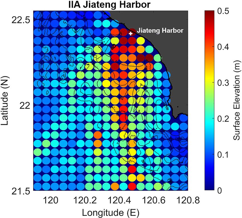
T.-C. Liu et al.: Historical tsunamis of Taiwan in the 18th century: the 1781 Jiateng Harbor flooding                       2523

and be devastated; the earthquake lasted for 8 h”) and its lo-    whereas the waves of KC traveled north of Kaohsiung. The
cation at the southern tip of Taiwan (Lin et al., 2009).          numerical gauge (Fig. 1c) records of FR and FS held also
   To model the evolution of tsunamis, nonlinear shallow wa-      higher values amid the scenarios (Fig. 6b). Moreover, the
ter equations were used with a bottom friction Manning coef-      wave crest reached to 3.5 m for the simulation of FS. The
ficient value of 0.013 for SMFs and seismic scenarios. Since      results that the half cycles of the first waves were all less
SMF tsunamis are generally local events, high-resolution          than 10 min support the description “in few quarters” in the
bathymetry of 100 m was employed, focusing on the study           historical report of the 1781 Jiateng Harbor flooding.
area at 0.05 arcmin numerical resolution. To model the evo-
lution of tsunamis triggered by SMFs, nonlinear shallow wa-
                                                                  3.2   The 1782 tsunami event
ter equations were used with a bottom friction Manning co-
efficient value of 0.013. On the other hand, nested grids
were set for the seismic tsunami scenarios. The first layer       To investigate the 1782 tsunami, we conducted four numer-
was conducted with 1 arcmin bathymetric data of ETOPO1            ical scenarios in order to reproduce the devastating event
from NOAA. Covering Taiwan (21.50–22.50◦ N, 119.10–               that matches the historical reports described as “no part of
122.50◦ E), the second layer bathymetry was extracted from        the flooded island remains visible except for the foot of the
the data downloaded from the Ocean Data Bank of the Tai-          mountains” (Jäger, 1784; Perrey, 1862). During the simu-
wan Ministry of Science and Technology (http://www.odb.           lation of the deformation front, which was generated by a
ntu.edu.tw/, data acquired in October 2014) at 200 m resolu-      Mw 7.5 earthquake near the Penghu Canyon, the tsunami
tion. Finally, bathymetric data of the third layer were adopted   wave mainly impacted on the coast of Tainan and Kaohsiung
from the fine coastal area data of Wu (2012). Combining the       (Fig. 7a). However, the wave heights recorded by the numer-
topographic data from the Department of Land Administra-          ical gauges at the Jiateng Harbor and Tainan were less than
tion of the Ministry of Interior and the Research Center for      0.5 m (Fig. 8a and b), far from matching the disastrous event
Space and Remote Sensing of the National Central Univer-          described in the historical reports of the 1782 tsunami event.
sity, together with the bathymetry provided by Taiwan Ocean          In contrast to the scenario of the deformation front, the re-
Research Center, the resolution of the third layer was inter-     sults of the Manila Trench indicated how destructive tsunami
polated to 27.5 m numerically from the original resolution of     scenarios could be. In particular, massively impacted ar-
0.0004 arcdeg.                                                    eas include the northern Philippines, southeast China, and
                                                                  the southern part of Taiwan (Fig. 7b and c). In Fig. 8, the
                                                                  surface fluctuations reached the height of 1.02 m at the Ji-
3     Results                                                     ateng Harbor and of 0.76 m at Tainan with the parame-
                                                                  ters of Wu (2012), yet the study sites were impacted by
3.1    The 1781 Jiateng Harbor flooding                           tsunami waves over 5 m in the other scenario of the Manila
                                                                  Trench. With the initial surface elevation of Qiu et al. (2019),
With the detailed descriptions documented in the report, it       the maximum wave height of the tsunami appeared over
is possible to reassess this historical event. From the sen-      5 m along the coastline of Tainan, Kaohsiung, and Pingtung
tences “Giant wave appeared and the water rose for tens of        (Fig. 7c). Time series of the numerical gauges showed that
zhang high (1 zhang approximately equals to 3–1/3 m); Peo-        tsunami waves arrived at the Jiateng Harbor study site after
ple were swinging on top of bamboos; In few quarters, the         20 min, impacting with a wave height of 6.59 m at first, then
water retreated quickly; The fisherman sailed on top of bam-      the second wave arrived after 1 h and 10 min with a height
boos on raft; When the wave ebbed, the rafters of the thatched    of 6.56 m (Fig. 8a). On the other hand, the first wave arrived
roofs were all gone” (Text S1 from Li et al., 2015), it was as-   at Tainan 39 min after the tsunami’s occurrence. The wave
sumed the wave height that stuck Jiateng Harbor was about         height recorded was 5.6 m, and the height of the second wave
2 m, close to the wave height that could affect the coastal       was reduced to 4.06 m (Fig. 8b). The fluctuations of the free
infrastructure (Yu, 1994) or even higher, and ebbed in few        surface decayed to less than 1 m after 4.5 h, about half of the
quarters.                                                         time (8 h) described in the historical reports.
   Li et al. (2015) considered that SMFs in the Kaoping slope        Finally, fault parameters of the Hengchun Fault (Wu,
region could have been the major contributor to the 1781/82       2012) were employed to investigate the 1782 event with sen-
tsunami event according to the available historical records       sible seismic movements (Fig. 7d). Limited tsunami waves
at that time, the numerical results, and the fact that offshore   generated by the Mw 7.6 Hengchun Fault earthquake were
southwest Taiwan is a SMF-prone environment. Submarine            expected for its location. Although parts of the Pingtung
landslide tsunami scenarios were then designed to investigate     coast faced tsunami waves over 3 m high, the maximum wave
and reconstruct the 1781 Jiateng Harbor flooding.                 height was less than 1 m in Tainan and less than 2 m in Dong-
   The maximum wave heights of SMF tsunami scenarios              gang area. Tsunami waves recorded by numerical gauges at
(Fig. 6a) showed that the tsunamis with sources located at        both study sites of the Jiateng Harbor and Tainan did not ex-
FR and FS traveled directly to the Jiateng Harbor study site,     ceed 0.6 m (Fig. 8a).

https://doi.org/10.5194/nhess-22-2517-2022                               Nat. Hazards Earth Syst. Sci., 22, 2517–2530, 2022
2524                T.-C. Liu et al.: Historical tsunamis of Taiwan in the 18th century: the 1781 Jiateng Harbor flooding

Figure 6. (a) Maximum wave height of the 1781 SMF tsunami simulations. The black cross denotes the numerical gauge of Jiateng Harbor
(22.417◦ N, 120.467◦ E). (b) Numerical gauge records at the Jiateng Harbor study site for the SMF scenarios of FR, FS, and KC. The 1 m
elevation is marked with dashed lines for comparison.

4   Discussion                                                       height of the FS scenario fits best the historical description,
                                                                     in particular the half cycle less than 10 min and the dura-
The findings from historical reports suggest that the 1781 Ji-       tion of “in few quarters”. Nevertheless, the SMFs alone could
ateng Harbor flooding and the 1782 tsunami should be two             hardly generate tsunamis that submerge Taiwan. In this study,
independent incidents. Based on a comprehensive investiga-           the disastrous scenario of Qiu et al. (2019) suggests that
tion of the historical reports, it is conspicuous that the de-       tsunamis triggered at the Manila Trench could contribute to
scriptions are pointing to different events, although the time       the 1782 tsunami event. However, historical records are not
of year is close. First of all, there is not any seismic move-       found for the tsunami waves in southeast China and northern
ment mentioned in the Chinese record of the 1781 Jiateng             Philippines at a time compatible with the event. Moreover,
Harbor flooding (Chen, 1830), while shaking movements and            it is unlikely that a severe tsunami in 1782 was not reported
tremors are documented in the German report for the 1782 in-         by any Chinese document. Therefore, the existence of the
cident (Jäger, 1784). Secondly, there are different descrip-         1782 tsunami is less possible and remains doubtful.
tions on the severity of the resulting damage. It is recorded            Li et al. (2015) were the first group who read, trans-
that the whole island of Formosa was inundated by ocean              lated, and reported the French record as documented by Per-
water till the foot of the mountains, and 40 000 people were         rey (1862). In this study, for the first time the historical doc-
killed in the 1782 tsunami event (Jäger, 1784). However, de-         uments (Gazette de France, 1783; Jäger, 1784) cited by Per-
spite the fact that the coastal area was impacted by the waves,      rey (1862) are fully translated and reported together. By ana-
only one person died in the 1781 Jiateng Harbor flooding             lyzing the historical records, the 1782 tsunami event is clar-
(Chen, 1830).                                                        ified not to be a typographical error of the 1867 Keelung
   The results of numerical simulations performed with               tsunami proposed by Lin (2006) since the literature records
COMCOT seem to indicate that the 1781 Jiateng Harbor                 (Gazette de France, 1783; Jäger, 1784; Mallet, 1854; Perrey,
flooding and 1782 tsunami are two different events. In the           1862) had existed already before the year 1867. Incoherence
SMFs study, tsunamis generated in southwest Taiwan, es-              was found amid historical reports of the 1782 tsunami event
pecially from the south-southwest direction, could be the            since seismic movements were not mentioned in the text of
main source of the 1781 Jiateng Harbor flooding. The wave            Gazette de France (1783) or Mallet (1854). While exam-

Nat. Hazards Earth Syst. Sci., 22, 2517–2530, 2022                                   https://doi.org/10.5194/nhess-22-2517-2022
T.-C. Liu et al.: Historical tsunamis of Taiwan in the 18th century: the 1781 Jiateng Harbor flooding 2525 Figure 7. The initial elevations and the maximum wave heights of the seismic tsunami scenarios of (a) the deformation front, (b, c) the Manila Trench and (d) the Hengchun Fault. Figure 8. The numerical gauge records at the study sites of (a) Jiateng Harbor and (b) Tainan. ining the historical documents, records of Griffiths (1785), active submarine mud volcanoes were observed in the off- Grosier (1785), and Davidson (1903), which reported the shore area of southwest Taiwan (Chen et al., 2014; Mai et storm event on 22 May 1782, also put the existence of the al., 2021), we shall neither rule out the possibility of multi- 1782 earthquake in doubt by following the procedure of val- ple hazards occurring coincidently or very close in the same idation of Mak and Chan (2007). Together with Chinese period (e.g., the eruption of Mount Pinatubo and Typhoon records and foreign documents of the year 1782 (Davidson, Yunya in 1991). Therefore, numerical simulations of storm 1903; Griffiths, 1785; Hsu, 2007; Rees, 1820; Yin, 2013), surges or complex hazards should be taken into considera- the fact that the significant water level was determined by tion in future studies. the storm surge should not be ignored. Meanwhile, since https://doi.org/10.5194/nhess-22-2517-2022 Nat. Hazards Earth Syst. Sci., 22, 2517–2530, 2022
2526                T.-C. Liu et al.: Historical tsunamis of Taiwan in the 18th century: the 1781 Jiateng Harbor flooding

   This research suffers some limitations, including the lack         A letter from China mentions an event that hap-
of gauge records of the two incidents and the evolution of            pened last year, and perhaps it’s more terrible than
coastal bathymetry and topography. In the past 200 years, the         those experienced in Sicily and Calabria which
coastline of southwest Taiwan has changed a lot due to the            at the beginning of this year suffered many dis-
sediment transportation and the erosion (Chang et al., 2018).         asters. Pending a more detailed narrative, here’s
Without knowing the exact bathymetry in the 18th century,             what they tell us: on 22 May 1782, the sea level
the accuracy of the numerical gauges may not be satis-                rose to a prodigious height on the coast of Fujian,
fied. Therefore, the figures of the maximum wave height,              covering almost the entire island of Formosa for
with which the tsunami flux propagation could be traced,              8 h, which is situated 30 leagues1 away. The water
should be taken into consideration in the first place. More-          ebbed, leaving most of the residential areas noth-
over, the landslide tsunamis require SMF dating to confirm            ing but piles of rubble, under which a part of the
the sources. Hence, further marine surveys are indispensable          huge population stayed buried. Wanting to inspect
for fully reconstructing the 1781 Jiateng Harbor flooding.            the effects of this disaster by himself, The Emperor
   Examining the historical events allows us to assess the            of China left the capital. During the journey go-
tsunami hazard and to prepare for natural disasters that could        ing through his provinces, the cries of his People,
possibly occur in the future. Results of the study based on           whipped up by the irritation of some Mandarins,
the IIA method show that the offshore region of southwest             struck his ears, and it is said that he executed over
Taiwan and the Luzon Trench could generate tsunamis that              300 people.
affect most of the southwestern coast of Taiwan. In fact,
tsunamis generated locally could impact the coastal area         A2    Text A2
within a very limited time. Hence, a proper evacuation plan
is needed for the residents at the seaside.                      (Translated from German to English by David Demes,
                                                                 June 2020)
                                                                    §116
                                                                    Following the changed order [of the text] mentioned in the
Appendix A: Translations of Gazette de France (1783)
                                                                 Scholion [i.e. commentary] of §112, the submerging of the
and Jäger (1784)
                                                                 Island of Formosa into the sea2 will constitute the third point.
                                                                    The French Foreign Minister [Ministre d’État] Bertin3 re-
A1     Text A1
                                                                 ceived a letter from a missionary in Beijing, which con-
                                                                 tained the most unfortunate news that, in October of 1782, on
Original text from Gazette de France.: De Paris, le
                                                                 the Island of Formosa, situated right off the coast of China,
12 Août 1783.
                                                                 fire-breathing mountains and maws unexpectedly burst open.
     Une lettre de la Chine fait mention d’un évènement          Accompanying their harrowing eruption were subterranean
     arrivé l’année dernière, & peut-être plus terrible          movements, causing the whole island to shake and be dev-
     encore que ceux qu’ont éprouvés la Sicile & la Cal-         astated. The ocean waves, which were pushed from east to
     abre dans le commencement de celle-ci féconde               west, evenly covered the whole of the submerged island so
     en désastres. En attendant une relation plus dé-            that no part of the flooded island remains visible except
     taillée, voici ce que l’on en raconte: Le 22 Mai            for the foot of the mountains. The shaking movements and
     de l’année dernière, la mer s’éleva sur les côtes           tremors continued for more than 8 h. The three most noble
     de Fo-Kien à une hauteur prodigieuse, & cou-                cities of this island (whose names we cannot inquire about on
     vrit presqu’entièrement pendant huit heures l’île de        the submerged island) alongside 20 market towns are buried
     Formose qui en est à 30 lieues. Les eaux, en se reti-       beneath the rubble and their remains were carried away by
     rant, n’ont laissé à la place de la plupart des habita-     the force of the sea. More than 40 000 residents, some of
     tions que des amas de décombres sous lesquels une           them native, some of them Chinese, who found their graves
     partie de la population immense de cette Isle est           in this accident, have been counted. All promontories that
     restée ensevelie. L’Empereur de la Chine, voulant           had projected into the sea have been washed away and the
     juger par lui-même des effets de ce désastre, est           locations where they had been situated have now been turned
     sorti de sa capitale; en parcourant ses provinces,          into reservoirs and dregs of water. The forts Seeland4 and
     les cris de son Peuple excités par vexations de                1 The ancient measurement unit “lieue” is about 4 km in length.
     quelques Mandarins, ont frappé ses oreilles; & on              2 The German Untergang may also refer to “doom”, “demise”,
     dit qu’il en a fait justice en faisant couper plus de       or “downfall”. In this context, a sinking or submerging into the sea
     300 têtes.                                                  seems more appropriate.
                                                                    3 Henri Léonard Jean Baptiste Bertin (1720–1792).
  (Translated from French to English by Tien-Chi Liu,               4 Fort Zeelandia, built in 1634 by the Dutch East India Com-
June 2020.)                                                      pany (VOC) in Anping.

Nat. Hazards Earth Syst. Sci., 22, 2517–2530, 2022                               https://doi.org/10.5194/nhess-22-2517-2022
T.-C. Liu et al.: Historical tsunamis of Taiwan in the 18th century: the 1781 Jiateng Harbor flooding 2527
Pingschingi as well as the hills they were built on have van- immediately so I can swiftly render aid. The homes
ished. In short, everything has been leveled by the water. For- and buildings devastated by the water shall be re-
mosa in 1782 and Messina in 17835 have shared the same built at my expense, and those damaged shall be re-
destiny and both have ceased to be what they once were. paired. You shall provide those unfortunate people
Scholion. The Island of Formosa is located in the Asiatic with all necessary food at my cost. You shall afford
Sea, between Japan, China, and the Islands of the Philip- everyone with my help without exception. It would
pines, 24 mi [176 km] off the Chinese coast. It is about 17 mi pain me if you neglected just one of them. They
[125 km] in length and 15 mi [110 km] in width. Just like Pic- should know that I am watching over all of them
cando and Legneto it is very fertile and rich in gold and sil- and that I love all of them fondly. You shall tell
ver ore. In the past, this island had its own king, up until them that it is me who is helping them, their lord
around 200 years ago when it was conquered by the Tartars6 . and father. Also, you shall use funds from the trea-
And after it had rid itself of their yoke, it was subdued by sury to rebuild as many warships and magazines
the Japanese 60 years ago. Of the Europeans, especially the as this almighty arm has taken from me through
Dutch have settled here and on the small isle of Taiwan built the storm and the waves. Do not shirk [from your
the Fort Seeland, which was in their possession for a long duty], I forbid it, and report back to me how you
time until it was taken from them in 1661 by the Chinese have obeyed my will.
pirate Coxinga7 .
Scholion. Because three different months have been given,
§117
namely the months of October, December, and May, the ac-
The information designating the time when this disaster
tual timing of when the Island of Formosa was destroyed can-
struck the island is not consistent. Then, a letter comes to
not be determined. It is enough for us to know the year. And
mind supposedly sent to the former Minister of War Mon-
from the letter sent by the missionary from Beijing to Mon-
sieur Bertin from Beijing by a Chinese who had been to Paris
sieur Bertin in the year of 1783 we can gather that during
many years before. Therein it states:
the eruption of the subterranean fires, the sea on the coast of
In December of 1782, various fire-breathing moun- China towered to an unnatural or unusual height and flooded
tains on the Island of Formosa began to open their and submerged the whole island so that not the tiniest bit
fiery jaws. Their dreadful eruption was accompa- could be seen for several days. And after the water had re-
nied by a massive subterranean movement, which treated, one could make out no sign at all, not of the human
shook the whole island and let it be submerged by population nor of any four-footed animals.
the seas rolling from east to west. The tremor lasted In all of history, one cannot find an incident so horrific like
longer than 8 h. More than 40 000 residents have the ones that happened in Formosa and Messina.
been counted that found their graves in this horrific
accident.
Code availability. The COMCOT version 1.7 conducted in this re-
And yet another message reported the following: a second search is currently not an open-source model but is available from
letter from Beijing arrived in Versailles that confirmed ev- the corresponding author upon reasonable request.
erything that had already been reported on the disaster of the
Island of Formosa. The suffering of a few thousand who had
escaped the stormy waves is said to be unspeakable – as one Data availability. The bathymetry data of ETOPO1 are publicly
can imagine. accessible at https://www.ngdc.noaa.gov/mgg/global/ (NOAA Na-
The emperor of China is said to have sent the following let- tional Geophysical Data Center, 2009). Meanwhile, the bathymet-
ter to the viceroy of the region of Feu-kim8 which we indent ric data of Taiwan used in this research are not open to the public
here because of its rather strange content (one may doubt due to homeland security, yet the one with 200 m resolution can
whether this letter was really written by the emperor): be access at https://www.odb.ntu.edu.tw/bathy/ (Ocean Data Bank,
2022) upon official applications. The results data of IIA and numer-
I have heard of the disaster that has befallen my Is- ical simulations are available from the first or corresponding author
land of Ray-Onan (i.e. Formosa) on 22 May 1782. I upon reasonable request.
hence order you to inquire in detail about the dam-
ages the remaining inhabitants of this unfortunate
island were forced to suffer and report back to me Author contributions. TRW conceptually designed the study and
supervised the research. TCL performed and analyzed the nu-
5 Reference to the 1783 Calabrian earthquakes. merical simulations and wrote the paper. SKH provided the fine
6 Reference to the Manchus, i.e. the Qing Dynasty. bathymetry data and provided constructive suggestions to the study.
7 Zheng Chenggong (1624–1662).
8 Probably a variant spelling of Fukien or Fujian Province. Dur-
ing the Qing Dynasty, the Governor General of Taiwan, Fujian, and Competing interests. The contact author has declared that none of
Zhejiang was known as the Viceroy of Min-Zhe. the authors has any competing interests.
https://doi.org/10.5194/nhess-22-2517-2022 Nat. Hazards Earth Syst. Sci., 22, 2517–2530, 20222528 T.-C. Liu et al.: Historical tsunamis of Taiwan in the 18th century: the 1781 Jiateng Harbor flooding
Disclaimer. Publisher’s note: Copernicus Publications remains upper Kaoping Slope off southwest Taiwan, Terr. Atmos. Ocean.
neutral with regard to jurisdictional claims in published maps and Sci., 29, 17–30, https://doi.org/10.3319/TAO.2017.06.14.01,
institutional affiliations. 2018.
Cheng, S.-N., Shaw, C.-F., and Yeh, Y. T.: Reconstructing
the 1867 Keelung Earthquake and Tsunami Based on His-
Special issue statement. This article is part of the special issue torical Documents, Terr. Atmos. Ocean. Sci., 27, 431–449,
“Tsunamis: from source processes to coastal hazard and warning”. https://doi.org/10.3319/TAO.2016.03.18.01(TEM), 2016.
It is not associated with a conference. Chiang, C. S. and Yu, H. S.: Morphotectonics and in-
cision of the Kaoping submarine canyon, SW Tai-
wan orogenic wedge, Geomorphology, 80, 199–213,
Acknowledgements. We would like to gratefully thank Qiang Qiu https://doi.org/10.1016/j.geomorph.2006.02.008, 2006.
and Linlin Li for kindly providing the initial surface elevation data Chiang, C.-S., Hsiung, K.-H., and Yu, H.-S.: Three types of modern
of the numerical simulation and for their helpful comments about submarine canyons on the tectonically active continental mar-
this research. We also acknowledge the editor, Alberto Armigliato, gin offshore southwestern Taiwan, Mar. Geophys. Res., 41, 1–17,
and the two anonymous reviewers for the valuable and construc- https://doi.org/10.1007/s11001-020-09403-z, 2020.
tive suggestions that have significantly improved the quality of this Chung, M.-J.: IIA and TATA approaches to reconstructing and an-
paper. Last but not least, we appreciate sincerely the support of alyzing the 1960 Chile and 1867 Keelung tsunami events, Mas-
the Seismology Center of Central Weather Bureau, the Center for ter thesis, National Central University, Taoyuan, Taiwan, http:
Astronautical Physics and Engineering (CAPE), and Earthquake- //ir.lib.ncu.edu.tw/handle/987654321/76757 (last access: 15 Oc-
Disaster and Risk Evaluation and Management Center (E-DREaM) tober 2021), 2018.
from the Featured Area Research Center program within the frame- Davidson, J. W.: The Island of Formosa, Past and Present: History,
work of the Higher Education Sprout Project by the Taiwan Min- People, Resources, and Commercial Prospects. Tea, Camphor,
istry of Education (MOE). Sugar, Gold, Coal, Sulphur, Economical Plants, and Other Pro-
ductions, Macmillan & Company, London, New York, 78 pp.,
ISBN 978-1504259927 [rep], 1903.
Fritz, H. M., Blount, C., Sokoloski, R., Singleton, J., Fuggle, A.,
Financial support. This study has been supported by the Tai-
McAdoo, B. G., Moore, A., Grass, C., and Tate, B.: Hurricane
wan Ministry of Science and Technology (MOST; grant
Katrina storm surge distribution and field observations on the
nos. MOST 108-2116-M-008-017 and MOST 110-2111-M-008-
Mississippi Barrier Islands, Estuar. Coast. Shelf Sci., 74, 12–20,
017).
https://doi.org/10.1016/j.ecss.2007.03.015, 2007.
Fritz, H. M., Blount, C., Thwin, S., Thu, M., and Chan, N.: Cy-
clone Nargis storm surge in Myanmar, Nat. Geosci., 2, 448–449,
Review statement. This paper was edited by Alberto Armigliato https://doi.org/10.1038/ngeo558, 2009.
and reviewed by two anonymous referees. Ganse, R. A. and Nelson, J. B.: Catalog of significant earthquakes
2000 BC to 1979, including quantitative casualties and damage,
Bull. Seismol. Soc. Am., 72, 873–877, 1982.
Gazette De France: De Paris, le 12 Août 1783, in: Gazette De
References France, Organe officiel du Gouvernement Royal, Paris, 288 pp.,
https://gallica.bnf.fr/ark:/12148/bpt6k6254403x/f4.item (last ac-
Carvajal, M., Sepúlveda, I., Gubler, A., and Garreaud, cess: 10 October 2021), 1783.
R.: Worldwide signature of the 2022 Tonga volcanic Ghobarah, A., Saatcioglu, M., and Nistor, I.: The impact
tsunami, Geophys. Res. Lett., 49, e2022GL098153, of the 26 December 2004 earthquake and tsunami on
https://doi.org/10.1029/2022GL098153, 2022. structures and infrastructure, Eng. Struct., 28, 312–326,
Chang, C.-J.: Documenting life in the era of climate change: Huang https://doi.org/10.1016/j.engstruct.2005.09.028, 2006.
Hsin-yao’s Nimbus and Taivalu, Asian Cinema, 30, 235–254, Greenslade, D. J. M. and Titov, V. V.: A Comparison Study
https://doi.org/10.1386/ac_00006_1, 2019. of Two Numerical Tsunami Forecasting Systems, Pure Appl.
Chang, Y., Chu, K.-W., and Chuang, L. Z.-H.: Sustainable coastal Geophys., 165, 1991–2001, https://doi.org/10.1007/s00024-008-
zone planning based on historical coastline changes: A model 0413-x, 2008.
from case study in Tainan, Taiwan, Landsc. Urban Plan., 174, Griffiths, R.: The Monthly Review, Or, Literary Journal, in:
24–32, https://doi.org/10.1016/j.landurbplan.2018.02.012, 2018. Vol. 72, R. Griffiths, London, 500 pp., https://www.google.
Chen, G.-Y.: Taiwan Interview Catalogue, http://tcss.ith.sinica.edu. com/books/edition/The_Monthly_Review_Or_Literary_Journal/
tw/cgi-bin/gs32/gsweb.cgi/ccd=WrA2D_/ebookviewer?dbid= 1TgoAAAAYAAJ?hl=en&gbpv=1&dq=TheMonthlyReview,
EB0000000055&db=ebook (last access: 7 October 2021), 1830. Or,LiteraryJournal,Volume72&pg=PA500&printsec=frontcover
Chen, S.-C., Hsu, S.-K., Wang, Y., Chung, S.-H., Chen, P.-C., (last access: 27 July 2022), 1785.
Tsai, C.-H., Lie, C.-S., Lin, H.-S., and Lee, Y.-W.: Distri- Grosier, J. B.: Description Générale de la Chine, ou Tableau de
bution and characters of the mud diapirs and mud volca- l’Etat Actuel de cet Empire, chez Moutard, Paris, 172–176,
noes off southwest Taiwan. J. Asian Earth Sci., 92, 201–214, https://play.google.com/books/reader?id=zcxfAAAAcAAJ&
https://doi.org/10.1016/j.jseaes.2013.10.009, 2014. pg=GBS.PA172&hl=fr (last access: 8 October 2021), 1785.
Chen, S. C., Tsai, C. H., Hsu, S. K., Yeh, Y. C., Liu, C. S., Chung,
S. H., and Wei, C. Y.: Fangliao Slide – a large slope failure in the
Nat. Hazards Earth Syst. Sci., 22, 2517–2530, 2022 https://doi.org/10.5194/nhess-22-2517-2022T.-C. Liu et al.: Historical tsunamis of Taiwan in the 18th century: the 1781 Jiateng Harbor flooding 2529 Han, W.-C., Liu, C.-S., Chi, W.-C., Chen, L., Lin, C.- Lett., 42, 8498–8506, https://doi.org/10.1002/2015GL065567, C., and Chen, S.-C.: Westward advance of the deforma- 2015. tion front and evolution of submarine canyons offshore Li, L., Switzer, A. D., Chan, C. H., Wang, Y., Weiss, R., and of southwestern Taiwan, J. Asian. Earth. Sci., 149, 6–19, Qiu, Q.: How heterogeneous coseismic slip affects regional https://doi.org/10.1016/j.jseaes.2017.07.001, 2017. probabilistic tsunami hazard assessment: A case study in the Horspool, N., Pranantyo, I., Griffin, J., Latief, H., Natawidjaja, South China Sea, J. Geophys. Res.-Solid, 121, 6250–6272, D. H., Kongko, W., Cipta, A., Bustaman, B., Anugrah, S. D., https://doi.org/10.1002/2016JB013111, 2016. and Thio, H. K.: A probabilistic tsunami hazard assessment Li, L., Switzer, A. D., Wang, Y., Chan, C.-H., Qiu, Q., and for Indonesia, Nat. Hazards Earth Syst. Sci., 14, 3105–3122, Weiss, R.: A modest 0.5-m rise in sea level will dou- https://doi.org/10.5194/nhess-14-3105-2014, 2014. ble the tsunami hazard in Macau, Sci. Adv., 4, eaat1180, Hossain, M. Z., Islam, M. T., Sakai, T., and Ishida, M.: Impact of https://doi.org/10.1126/sciadv.aat1180, 2018. Tropical Cyclones on Rural Infrastructures in Bangladesh, in: Lin, A. T., Yao, B., Hsu, S.-K., Liu, C.-S., and Huang, C.-Y.: Tec- Agric. Eng. Int. CIGR E J. Invited Overview, 2, Agricultural En- tonic features of the incipient arc-continent collision zone of Tai- gineering International: the CIGR Ejournal, 1–13, ISSN 1682- wan: Implications for seismicity, Tectonophysics, 479, 28–42, 1130, 2008. 2009. Hsu, H.: Source materials on the history of natural disasters in Lin, M.-S.: The Study Methods of Historical Tsunami Research Ching Taiwan, in: New Edition, Fujian People’s Publishing (Taiwan), Ti-Chih, 25, 71–81, 2006. House, Fujian, ISBN 9787211054497, 2007. Liu, C. S., Lundberg, N., Reed, D. L., and Huang, Y. L.: Mor- Hsu, S.-K., Sibuet, J.-C., Monti, S., Shyu, C.-T., and Liu, C.- phological and seismic characteristics of the Kaoping Submarine S.: Transition between the Okinawa trough backarc extension Canyon, Mar. Geol., 111, 93–108, https://doi.org/10.1016/0025- and the Taiwan collision: new insights on the southernmost 3227(93)90190-7, 1993. Ryukyu subduction zone, Mar. Geophys. Res., 18, 163–187, Liu, P. L.-F., Woo, S.-B., and Cho, Y.-S.: Computer Programs https://doi.org/10.1007/BF00286076, 1996. for Tsunami Propagation and Inundation, Technical report, Hsu, S.-K., Liu, C.-S., Shyu, C.-T., Liu, S.-Y., Sibuet, J.-C., Lalle- Cornell University, New York, https://tsunamiportal.nacse.org/ mand, S., Wang, C., and Reed, D.: New gravity and mag- documentation/COMCOT_tech.pdf (last access: 16 September netic anomaly maps in the Taiwan-Luzon region and their pre- 2021), 1998. liminary interpretation, Terr. Atmos. Ocean. Sci., 9, 509–532, Liu, P. L.-F., Wang, X., and Salisbury, A. J.: Tsunami hazard and https://doi.org/10.3319/TAO.1998.9.3.509(TAICRUST), 1998. early warning system in South China Sea, J. Asian Earth. Sci., Hsu, S.-K., Lin, S.-S., Wang, S.-Y., Tsai, C.-H., Doo, W.-B., 36, 2–12, https://doi.org/10.1016/j.jseaes.2008.12.010, 2009. Chen, S.-C., Lin, J.-Y., Yeh, Y.-C., Wang, H.-F., and Su, C.- Ma, K.-F. and Lee, M.-F.: Simulation of historical tsunamis W.: Seabed gas emissions and submarine landslides off SW Tai- in the Taiwan region, Terr. Atmos. Ocean. Sci., 8, 13–30, wan, Terr. Atmos. Ocean. Sci., 29, 7–15, https://doi.org/10.3319/ https://doi.org/10.3319/TAO.1997.8.1.13(T), 1997. TAO.2016.10.04.01, 2018. Mai, H.-A., Lee, J.-C. Chen, K.-H., and Wen, K.-L.: Coulomb Hsu, Y.-J., Yu, S.-B., Loveless, J. P., Bacolcol, T., Solidum, R., stress changes triggering surface pop-up during the 2016 Mw 6.4 Luis Jr., A., Pelicano, A., and Woessner, J.: Interseismic defor- Meinong earthquake with implications for earthquake-induced mation and moment deficit along the Manila subduction zone and mud diapiring in SW Taiwan, J. Asian Earth Sci., 108, 104847, the Philippine Fault system, J. Geophys. Res.-Solid, 121, 7639– https://doi.org/10.1016/j.jseaes.2021.104847, 2021. 7665, https://doi.org/10.1002/2016JB013082, 2016. Mak, S. and Chan, L.-S.: Historical tsunamis in south China, Huang, W.-P., Hsu, C.-A., Kung, C.-S., and Yim, J. Z.: Numerical Nat. Hazards, 43, 147–164, https://doi.org/10.1007/s11069-007- studies on typhoon surges in the Northern Taiwan, Coast. Eng., 9113-6, 2007. 54, 883–894, https://doi.org/10.1016/j.coastaleng.2007.05.015, Mallet, R.: Third report on the facts of Earthquake Phenom- 2007. ena. Catalogue of recorded Earthquakes from 1606 B.C. to Jäger, J. L.: Philosophisch und Physicalische Abhandlungen A.D. 1850, Report of the Twenty-Third Meeting of the British über verschiedene Materien aus dem Reiche der Natur, Association for the Advancement of Science, London, 202 pp., J. A. Stein, Nürnberg, 150–155, https://mdz-nbn-resolving.de/ https://play.google.com/books/reader?id=iXdRAAAAYAAJ& details:bsb10131280 (last access: 8 October 2021), 1784. pg=GBS.RA1-PA202&hl=fr, (last access: 3 October 2021), Lau, A. Y. A., Switzer, A. D., Dominey-Howes, D., Aitchison, J. 1854. C., and Zong, Y.: Written records of historical tsunamis in the Manneela, S. and Kumar, S.: Overview of the Hunga Tonga-Hunga northeastern South China Sea – challenges associated with de- Ha’apai Volcanic Eruption and Tsunami, J. Geol. Soc. India, 98, veloping a new integrated database, Nat. Hazard. Earth. Sys., 10, 299–304, https://doi.org/10.1007/s12594-022-1980-7, 2022. 1793–1806, https://doi.org/10.5194/nhess-10-1793-2010, 2010. Matias, L. M., Cunha, T., Annunziato, A., Baptista, M. A., and Car- Lee, C.-J.: The Development of Taiwan Tsunami Fast Calculation rilho, F.: Tsunamigenic earthquakes in the Gulf of Cadiz: fault System and Reconstructing of the 1867 Keelung Tsunami Event, model and recurrence, Nat. Hazards Earth Syst. Sci., 13, 1–13, Master thesis, National Central University, Taoyuan, Taiwan, https://doi.org/10.5194/nhess-13-1-2013, 2013. http://ir.lib.ncu.edu.tw/handle/987654321/65015 (last access: 7 Megawati, K., Shaw, F., Sieh, K., Huang, Z., Wu, T.-R., Lin, Y., October 2021), 2014. and Pan, T.-C.: Tsunami hazard from the subduction megath- Li, L., Switzer, A. D., Wang, Y., Weiss, R., Qiu, Q., Chan, C.-H., and rust of the South China Sea: Part I. Source characterization Tapponnier, P.: What caused the mysterious eighteenth century and the resulting tsunami, J. Asian Earth. Sci., 36, 13–20, tsunami that struck the southwest Taiwan coast?, Geophys. Res. https://doi.org/10.1016/j.jseaes.2008.11.012, 2009. https://doi.org/10.5194/nhess-22-2517-2022 Nat. Hazards Earth Syst. Sci., 22, 2517–2530, 2022
You can also read