Hemswell and Harpswell - Character Assessment July 2018 - West ...
←
→
Page content transcription
If your browser does not render page correctly, please read the page content below
Hemswell and
                                                    Harpswell
                                                    Character Assessment

                                                    July 2018

                                                       CARROLL PLANNING + DESIGN
©Carroll Planning + Design 2018   Hemswell and Harpswell Character Assessment   1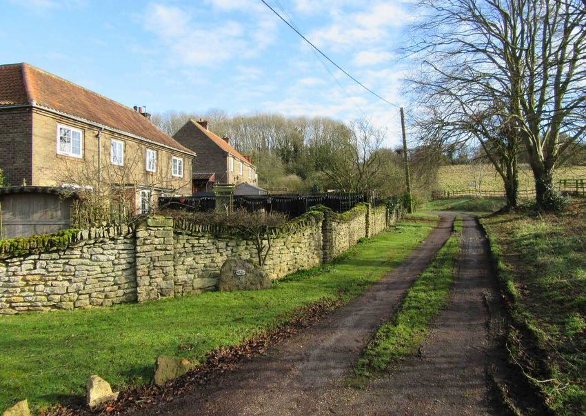
THIS PAGE IS LEFT INTENTIONALLY BLANK

©Carroll Planning + Design 2018                                           Hemswell and Harpswell Character Assessment   2
CONTENTS

         1. INTRODUCTION					4

         2. LANDSCAPE SETTING				6

         3. SETTLEMENT CHARACTER PROFILES		              20

         			- Hemswell				22

         			- Harpswell				52

         APPENDIX 1 - Hemswell Designated Heritage Assets

         APPENDIX 2 - Hemswell Non-designated Heritage Assets

         APPENDIX 3 - Harpswell history: An extract from ‘Change
                     and Continuity - Rural Settlement in north-west
                     Lincolnshire’

         APPENDIX 4 - Harpswell Landscape and Community Project:
                     An etract from ‘Medieval Archaeology’

         APPENDIX 5 - Harpswell Designated Heritage Assets

         APPENDIX 6 - Harpswell Non-designated Heritage Assets

       Prepared by:

       CARROLL PLANNING + DESIGN
       Woodpark
       Cappaduff
       Mountshannon
       County Clare
       Ireland
       V94 AE8P

       Telephone

       www.carrollplanningdesign.com

       on behalf of:
       Hemswell Parish Council                                         NB: Report should be printed and viewed in A3 format

©Carroll Planning + Design 2018                                                         Hemswell and Harpswell Character Assessment   3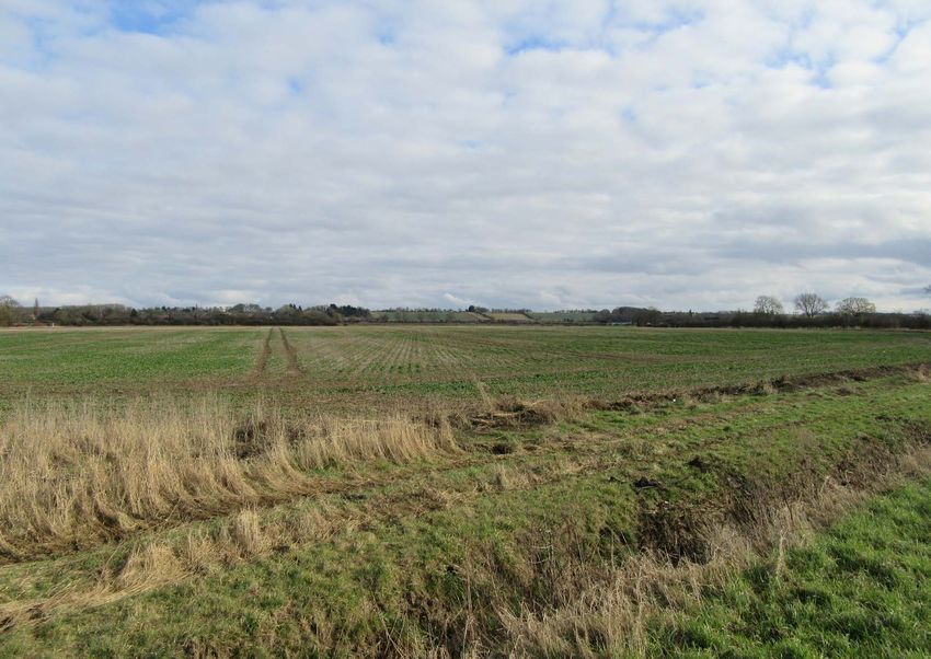
1        INTRODUCTION
©Carroll Planning + Design 2018   Hemswell and Harpswell Character Assessment   4
1       INTRODUCTION

Purpose of the assessment                                                                                                         1.8      In preparing this Character Assessment, the following approaches to understanding and documenting the distinct
                                                                                                                                  local character have been progressed:
1.1     Character assessments record the special qualities that give an area its sense of place and unique identity. They
are widely recognised as useful tools, helping to aid the planning, design and management of future development in a              • Desktop research, including:
particular locality.
                                                                                                                                  - Analysis of historic and recent maps;
1.2     The National Planning Policy Framework (NPPF) recognises the value of local distinctiveness and supports the use          - Review of existing evidence, including the the West Lindsey Landscape Character Assessment (1999) and Hemswell
of characterisation studies, such as character assessments, to underpin and inform planning policy. Specifically, paragraph       Conservation Area Appraisal (1985); and
58 of the NPPF states that:                                                                                                       - Identification of designated and non-designated Heritage Assets.

‘Local and neighbourhood plans should develop robust and comprehensive policies that set out the quality of development           • Detailed on-site survey of the villages, and the recording of key characteristics and features.
that will be expected for the area. Such policies should be based on stated objectives for the future of the area and an
understanding and evaluation of its defining characteristics. Planning policies and decisions should aim to ensure that           • Discussions with members of the Parish Council and other residents involved in the preparation of the Hemswell and
developments: respond to local character and history, and reflect the identity of local surroundings and materials, while not     Harpswell Neighbourhood Plan.
preventing or discouraging appropriate innovation’.
                                                                                                                                  1.9      The latter approach is particularly critical to the preparation of a comprehensive character assessment, ensuring
1.3    This Character Assessment provides an overview of the key qualities and characteristics that define the Parishes           that certain built and natural features which are perhaps less obvious to an outside expert, but are valued  and appreciated
of Hemswell and Harpswell (Fig 1), with a particular focus on the two main settlements within this area Hemswell and              by local communities, are highlighted and have their importance communicated within the character assessment.
Harpswell. The Character Assessment has been prepared in support of a larger project – the production of the Hemswell
and Harpswell Neighbourhood Plan. Once adopted, the Neighbourhood Plan will be used by West Lindsey District Council
when considering planning applications for development within the Neighbourhood Plan area.

1.4      The key role neighbourhood planning has in achieving high quality places and the importance of understanding
local character and context to inform such plans is acknowledged in the government’s planning practice guidance
(Reference ID: 20-030-20140306), which states that:

‘A Local or Neighbourhood plan is essential to achieving high quality places. A key part of any plan is understanding and
appreciating the context of an area, so that proposals can then be developed to respect it. Good design interprets and
builds on historic character, natural resources and the aspirations of local communities’.

1.5     This Character Assessment supports the design and character policies progressed within the Hemswell and
Harpswell Neighbourhood Plan. It is intended to be used by developers, architects, designers, planners, and the local
community to help to ensure that all future development and change in the parish is not only of high design quality, but is
also appropriate and complementary to the distinct and special character of the local area.

Assessment methodology

1.6    Recognising that the character of any settlement is formed by more than just the appearance of the buildings
which occupy it, this Character Assessment considers a broad range of influences, including:

•   Historical evolution of the parish settlements;
•   Landscape setting;
•   Structure, spacing and layout;
•   Vegetation and planting;
•   Built form;
•   Landmarks;
•   Views and vistas; and
•   Streetscape.

1.7     While the primary objective of this assessment is to identify the qualities and positive characteristics of each of the                                                                                                        Hemswell and
parish settlements, where appropriate, existing development which fails to contribute positively to local character is also                                                                                                            Harpswell Parish
highlighted. The identification of negative forms of development ensures that a holistic assessment of the local character is
presented. In addition, this approach can also help to identify opportunities where local character might be reinforced and
                                                                                                                                         N                                                                                             Areas

enhanced.
                                                                                                                                  Fig 1: The combined Hemswell and Harpswell Parish areas
                                                                                                                                                      Contains OS data © Crown copyright and database rights 2020. OS Licence No. 100018701

©Carroll Planning + Design 2018                                                                                                                                                                        Hemswell and Harpswell Character Assessment           5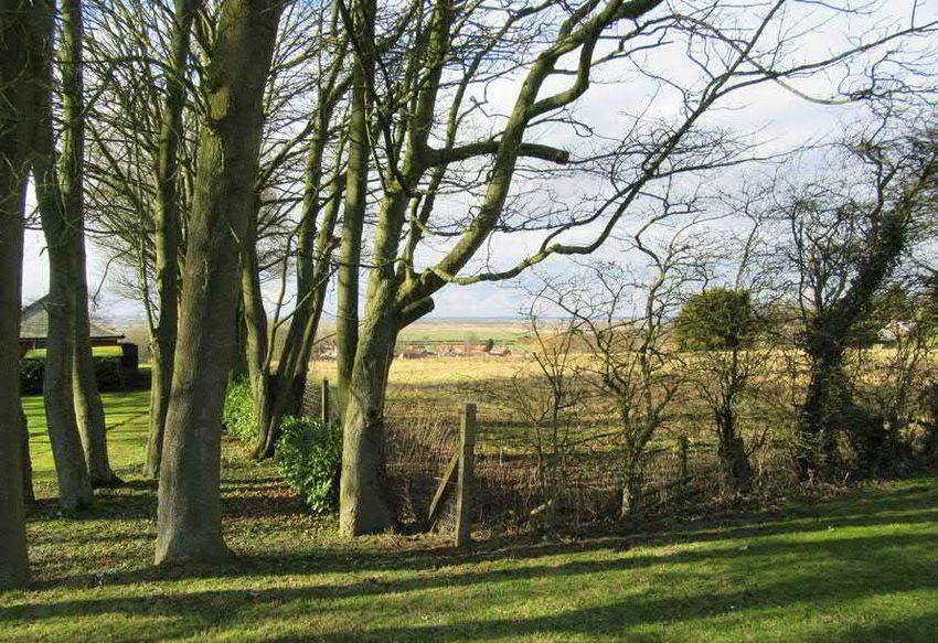
2   LANDSCAPE SETTING
©Carroll Planning + Design 2018        Hemswell and Harpswell Character Assessment   6
2       LANDSCAPE SETTING

Wider landscape features                                                           landscape character to the setting of the springline villages that lie at the foot of its      rows or clusters of localised tree planting.
                                                                                   slopes, such as Hemswell and Harpswell, but also acknowledges the attractive and
2.1       Hemswell and Harpswell are located relatively centrally within the       historic character of these villages and the importance of these small settlements to          Significance of landscape setting and key characteristics
district of West Lindsey approximately 11km east of Gainsborough and 18km          the distinct character of the Cliff LCA.
north of Lincoln. Situated along the Lincoln Cliff, a Jurassic limestone scarp,                                                                                                   2.10     As two of several historic springline villages that were established along the
Hemswell and Harpswell benefit from a particularly distinct and dramatic           The Till Vale LCA                                                                              Lincoln Cliff in order to benefit from the springs formed by this area’s unique geology,
landscape setting. East of the Lincoln Cliff, the landscape falls gently towards                                                                                                  Hemswell’s and Harpswell’s history and evolution, as well as their current day
the plains of the River Ancholme, whilst to the west a similar change in           2.8      The WLLCA describes the Tilll Vale LCA as an ‘agricultural landscape with             character, are intrinsically linked to their landscape setting and their relationship with
gradient is seen across the Till Vale and Trent Vallley.                           large, flat, open fields and a strong rural character’. This flat and open landscape           the limestone escarpment. The importance and unique character of this landscape
                                                                                   character allows for long views from across the Till Vale LCA eastwards towards the            setting is recognised by the ‘Area of Great Landscape Value’ designation that covers
2.2       Fig 2 illustrates Hemswell and Harpswell’s location relevant to the      scarp and the springline villages that sit below it, including Hemswell and Harpswell..        large areas of both Hemswell and Harpswell, and is designed to protect important
district’s wider key landscape characteristics.                                                                                                                                   views both view towards, from and across the Cliff.
                                                                                   2.9    The eastern extents of this LCA accommodate several isolated farmhouses
                                                                                   and concentrated groupings of agricultural buildings, and these also often include             2.11     Both Hemswell and Harpswell are typical of the Lincoln Cliff’s sprngline
West Lindsey Landscape Character Assessment (1999)

2.3      The West Lindsey Landscape Character Assessment (WLLCA),
published in 1999, provides a detailed assessment of the special character
and distinct qualities that shape the various landscape types found across
the district.

2.4      The WLLCA identifies 14 different Landscape Character Areas
(LCAs) within West Lindsey, each with its own specific combination of
characteristics and unique qualities. Of these areas, the villages of Hemswell
and Harpswell are positioned within the narrow boundaries of the Cliff LCA,

                                                                                                                                 River Anch
whilst the western extents of the parishes lie within the Till Vale LCA (see Fig
3). The below sub-sections briefly discuss the key characteristics of each of              Hemswell and
these LCA’s, and their relationship with Hemswell and Harpswell.                            Harpswell

                                                                                                                                    olme
The Cliff LCA

2.5     The landscape character of Hemswell and Harpswill is most
influenced by the Lincoln Cliff and the prominent and pronounced slope (Fig
                                                                                             River T

4) created by this unique landform. The Cliff LCA documents the landscape
character and qualities of this straight, limestone capped scarp and its
                                                                                                    rent

influence on the local landscape as it cuts its way through the centre of West                                                                                     Lincolnshire
Lindsey                                                                                                                                                               Wolds

                                                                                                                                              Ba
                                                                                                                                              rli
                                                                                                                                                  ng
2.6       Specially, the WLLCA includes the following observations regarding

                                                                                                                                                   Eas
the Cliff LCA, which are relevant to Hemswell and Harpswell and their

                                                                                                                                                      u
immediate landscape setting:
                                                                                                              Lincoln
                                                                                                                Cliff
• Straight and prominent limestone capped scarp slope (Fig 4), with a due
north-south alignment that extends across the centre of the district. The
scarp forms a backdrop for views across the Till Vale.
                                                                                                           Waterways

• Diverse pattern of mixed pasture and arable land with good hedgerow                                      Hemswell and                                                                     The Till Vale Landscape Character Area (as denoted in the WLLCA)
boundaries.                                                                                                Harpswell
                                                                                                                                                                                            The Cliff Landscape Character Area (as denoted in the WLLCA)
• Historic halls and associated parkland landscapes.
                                                                                              Ordnance Datum (OD)
                                                                                                                                                                                            The Limestone Dip Landscape Character Area (as denoted in the WLLCA)
• Several compact, quiet and secluded ‘springline’ villages, which are                                     Over 150m            90 - 120m                 30-60m
of historic character and with many trees, and which are positioned in                                                                                                                      Hemswell and
                                                                                                           120  - 150m          60 - 90m                  Below 30m                                                               West Lindsey District boundary
attractive settings at the foot of the scarp.                                                                                                                                               Harpswell

2.7     Importantly, the WLLCA recognises not only the significance of the         Fig 2: West Lindsey physical features map                                                      Fig 3: Hemswell and Harpswell are positioned within the Cliff Landscape Character Area.
©Carroll Planning + Design 2018                                                                                                                                                                                   Hemswell and Harpswell Character Assessment               7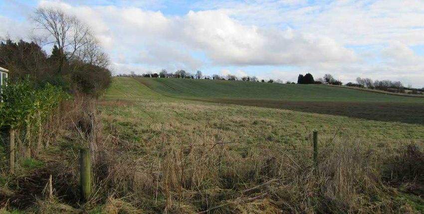
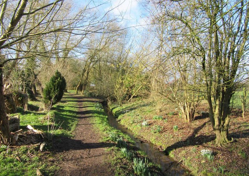
villages. Positioned at the foot of the escarpment, each village has resisted development further up the slope, leaving 2.16 Dispersed farms represent the only common built forms in this western landscape setting. These traditional
the cliff top and the upper escarpment characteristically undeveloped. Similarly, along their north, south and western farmsteads tend to benefit from localised tree planting in and around their immediate setting, which helps to reduce their
boundaries, both villages have managed to maintain their compact settlement footprints. Neither village has been subject visual impact and integrate them into the rural setting. Examples of such remote, rural farms within the Neighbourhood
to any significant ribbon development nor extended outwards into immediate adjoining landscape setting. Rather, new Plan Area include Harpswell Grange (Fig 5), Harpswell Low Farm (Fig 6), Hermitage Low Farm, and Billyards Farm.
development has typically been incremental and accommodated on infill sites within the established villages boundaries.
The lack of any significantly visible development outside of the well-established confines of each settlement is a key 2.17 One anomaly within the Neighbourhood Plan Area’s landscape setting is Harpswell Hill Park, a small, self-contained
attribute of each. residential park, which abuts the northern edge of Harpswell Lane. However, the modest scale of buildings that occupy
this site help minimise its visual impact and help to ensure that despite its remote and detached rural setting, it does not
2.12 Hemswell’s and Harpswell’s compact character is complemented by the abundance of tree planting and mature detract from the character and quality of the surrounding landscape.
hedgerows that typify the village edges. Such planting gives each settlement a pleasingly soft and verdant edge that
responds positively to the surrounding rural landscape setting. Indeed, in the majority of views towards both Hemswell 2.18 The photography found at Fig 8 - 28 provides a visual record of the distinct character of Hemswell’s and Harpswell’s
and Harpswell, the villages resemble more a woodland than a settlement, with planting in the foreground screening views landscape setting. These images illustrate many of the key landscape characteristics discussed above, and each image is
into the village and tree canopies dominating the village skyline to the extent where glimpses of rooftops or built forms are accompanied by descriptive text which provides further commentary on the distinct landscape setting displayed across
quite limited. Hemswell and Harpswell. The map at Fig 7 accompanies these images, denoting the viewpoint locations of each of the
views.
2.13 The verdant character of each village carries through to the upper escarpment and cliff top areas above both
Hemswell and Harpswell, and in views from the west, each of the two settlements are read against this undeveloped,
wooded escarpment backdrop.
2.14 In contrast, the land that sits between the two settlements and runs along the escarpment is of an open,
agricultural character. This exposed, green gap along the cliff gives legibility to long views from the west, helping the
viewer to decipher the precise extents of each village and to understand the positioning of each relevant to the other. The
undeveloped nature of this green gap also plays a crucial role in providing separation between the two settlements and
protecting the unique identifies of each.
2.15 From the top of the Cliff, there are long distance panoramic views west that stretch across the rest of the
Neighbourhood Plan Area towards the Trent Valley and beyond. This western landscape setting, extending away from the
elevated landscape of the Cliff, displays a more uniform, less dramatic landscape character, but has a charm and identity
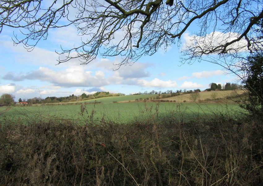
of its own. It is open and flat agricultural landscape, with large fields that are typically edged by low hawthorn hedgerows.
Hedgerow tree planting is minimal, which further contributes to the open character of this distinctly rural landscape.
Fig 4: The Lincoln Cliff escarpment sweeps up from the flat low-lying landscape of the Till Vale to form a dramatic landscape feature Fig 5 and 6: Within the Neighbourhood Plan Area, development outside of the established village boundaries is largely restricted to
which extends north-south and forms a unique backdrop to the villages of Hemswell and Harpswell. isolated farmsteads, comprising small clusters of agricultural buildings and farmhouses.
©Carroll Planning + Design 2018 Hemswell and Harpswell Character Assessment 8
Landscape views - key

                      VIewpoint

                      Middle Street (B1398)

                      Harpswell Lane (A631)

                                                                                                    5
                                                                        1 2     3               4

                                                                                HEMSWELL
                                                                                                        6
                                                                            8                           7
                                                                9

                                                   12                                      14
                                                        11 10
                                              13

                                                                                           15

                                                                                                            HARPSWELL
                                                                                           16

                                                                                      17
                                                                                                                             21
                                                                                                                        20

                                                                    18 19

                  HARPSWELL
                    WOOD

       N
Fig 7: Selected landscape views map

©Carroll Planning + Design 2018                                                                                                   Hemswell and Harpswell Character Assessment   9
1

Fig 8: Wide, far-reaching views can be gained from the western edge of Hemswell. These views extend out across the flat, agricultural landscape of the Till Vale and are topped by big skies and feature little in the way of built forms, aside from the notable exception of West Burton
Power Station, whose chimneys form a distinct landmark in the far distance.

                                                                                                                                                         3
    2
                                                                                                                                                  Fig 10: A band of mature tree planting, standing in a elevated position towards the top of the Lincoln Cliff, provides a soft and verdant
Fig 9: Much of Hemswell’s immediate landscape setting is comprised of small, mixed-pasture fields enclosed by hedgerows.                          backdrop to dwellings on Brook Street.
©Carroll Planning + Design 2018                                                                                                                                                                                             Hemswell and Harpswell Character Assessment                       10
4
Fig 11: Tree planting in and around Hemswell screens much of the village, even in elevated views from the east of the village, where only the settlement’s tallest built structures, such as All Saints Church successfully compete with the extensive tree canopies that dominate the views
into the village and the settlement skyline.
5
Fig 12: At both Hemswell and Harpswell, bands and clusters of tree planting towards the cliff ridge provide the settlements with handsome wooded backdrops.
©Carroll Planning + Design 2018 Hemswell and Harpswell Character Assessment 116 8
Fig 13: Breaks in the roadside boundary planting along Middle Street allows for glimpses of the distinct red pantile roofs of those properties that comprise the Fig 15:Looking south-east on the Hemswell Lane approach into Hemswell, the exposed profile of the Lincoln Cliff can
north-eastern extents of Hemswell, beyond which stretches out the flat, agricultural landscape of the Till Vale. be viewed through breaks in the field boundary planting.
7
Fig 14: At the top of the Lincoln Cliff the land briefly plateaus before again falling away to the east, resulting in wide, open views from Middle Street that terminate in the in the near-distance with an uncomplicated horizon, which contains few physical features other than the roof
profiles of some of the industrial buildings that now occupy the former Royal Air Force air base at the nearby settlement of Hemswell Cliff.
©Carroll Planning + Design 2018 Hemswell and Harpswell Character Assessment 129
Fig 16: Hemswell resembles a woodland rather than a village in views from Hemswell Lane, with the settlement being largely screened along its western edge by mature tree planting that gives it a pleasingly soft, wooded appearance that responds positively to the surrounding
rural landscape setting.
HEMSWELL HARPSWELL
10
Fig 17: Looking east from the junction of Hemswell Lane and Harpswell Lane (A631) reveals a wide panoramic view towards the Lincoln Cliff, whose rising form terminates the view. Within this view,both Hemswell and Harpswell nestle at the foot of the Cliff behind a foreground of
mature tree planting, whilst to the rear of each settlement the Cliff rises up above the villages and provides them each with a distinct and characterful backdrop.
©Carroll Planning + Design 2018 Hemswell and Harpswell Character Assessment 1311 12
Fig 18: Harpswell accommodates several isolated farms within its parish boundaries, which are typically set within mature, heavily Fig 19: Long views out across the Till Vale from the junction of Hemswell Lane and Harpswell Lane (A631) reveal an expansive
planted settings. agricultural landscape, comprised of large fields edged by low-lying hedgerows and with minimal tree cover.
HEMSWELL UNDEVELOPED AND EXPOSED HARPSWELL
AGRICULTURAL GAP
13
Fig 20: The flat character of the land that occupies the western extents of the Neighbourhood Plan Area allows for uninterrupted, open views towards Hemswell and Harpswell and their cliff setting. In this view, the rising profile of the scarp is most easily read by observing the
stretch of land that runs along the cliff and separates Hemswell and Harpswell, its undeveloped and agricultural character exposing the precise slope of the cliff landform. This agricultural gap also allows the extents and positioning of both Hemswell and Harpswell to be easier read,
and is crucial in providing clear separation between the two and preventing their coalescence.
©Carroll Planning + Design 2018 Hemswell and Harpswell Character Assessment 1414 15 Fig 21 and 22: Exiting Hemswell at Weldon Road is a right of way that runs southwards along the foot of the escarpment and spans the undeveloped green gap between Hemswell and Harpswell. From this pedestrian route an almost cross-sectional view can be gained of the distinct landscape gradient that underlies the two villages. The soft, planted edges of both Hemswell and Harpswell, which frame the open fields that lie between the two settlements are also a notable characteristic within these views. ©Carroll Planning + Design 2018 Hemswell and Harpswell Character Assessment 15
16
Fig 23: Gazing eastwards across the land that once accommodated the post-medieval house and gardens of Harpsewll Hall, the village appears at the centre of the view, where its built forms rest at the foot of the Lincoln Cliff and are set against the distinct and handsome backdrop
of the rising and densely wooded escarpment. As highlighted by this view, the fields that form Harpswells immediate western landscape frequently accommodate bands of mature tree planting, which are interspersed amongst field boundary hedgerows, adding an extra level of
visual interest to the landscape and enhancing the overall quality of views into towards Harpswell.

                                                                                                                            HARPSWELL

     17

Fig 24: The flat and open pastoral landscape that defines the western half of Harpswell Pairsh gives way to a more enclosed, wooded landscape at Hemswell village. In this view, Harpswell’s position in the landscape can be identified by the elevated woodland that looms above the
village’s built core and creates a gentle wooded arch along the skyline above the settlement.
©Carroll Planning + Design 2018                                                                                                                                                                                          Hemswell and Harpswell Character Assessment                  16
18
Fig 25: Views looking west from along Common Lane present a landscape comprised of open arable fields, within which sit occasional isolated farms, such as Hermitage Low Farm. Positioned to the right of this view, and forming a distinct feature on the horizon is Harpswell Wood,
which lies to the western end of the parish.
19
Fig 26: The contrasting character of the flat, open landscape of the Till Vale LCA and the rising, wooded nature of the Cliff LCA is one of the defining characteristics of Hemswell and Harpswell. These neighbouring landscape typologies combine to create picturesque, uninterrupted
views from the west of the Neighbourhood Plan Area towards the Lincoln Cliff and the settlements of Hemswell and Harpswell, which sit along the escarpment.
©Carroll Planning + Design 2018 Hemswell and Harpswell Character Assessment 1720
Fig 27: From Middle Street, which runs along the cliff ridge, expansive and far-reaching views can be obtained across the lower-lying landscape of the Till Vale. From this vantage point glimpses can be gained of elements of Harpswell’s roofscape, including local landmarks such as
St Chad’s Church and Hermitage Lodge. Less pleasing is the large agricultural building positioned to the left of the view, which is of a scale and bulk unseen elsewhere in the parish. Sited in an exposed location without any form of landscaping or screening, this substantial structure
disrupts the otherwise open character of the landscape and adversely impacts upon the quality of the view.
21
Fig 28: From above Harpswell, views east from Middle Street comprise a foreground of wide, open arable land, to which Hemswell Cliff’s more substantial industrial buildings form a backdrop. On clear days, stunning long distance views of the Lincolnshire Wolds, some 25km to the
east, can be obtained from this vantage point.
©Carroll Planning + Design 2018 Hemswell and Harpswell Character Assessment 18Landscape character recommendations 2.19 Based on the commentary set out within this landscape character summary, the following recommendations are made in order to protect and enhance the unique and locally distinct landscape setting of Hemswell and Harpswell: - Both Harpswell and Hemswell benefit from soft, verdant edges in long views towards the settlements, with built forms almost entirely screened from view. Poorly designed and/or located edge-of-village development, which disrupts the village’s soft, generously planted village edges and gateways, should be resisted. All proposals for new development should integrate into the village’s landscape setting and avoid creating unsatisfactory, overly hard edges to the villages. - In views from the west both Hemswell and Harpswell are read against the distinct and picturesque backdrop of the undeveloped, partially-wooded escarpment, which rises up behind them. This dramatic landscape feature is intrinsically linked to the character of both Hemswell and Harpswell. Therefore, development which would introduce exposed and prominent built forms along the Cliff should be resisted. - Outside of the established developed extents of Hemswell and Harpwell, new development forms, such as agricultural buildings, should be carefully sited and designed so as to minimise their visual impact on the landscape setting. This is particularly crucial within the flat and open landscape of the Til Vale, which characterises much of the western extents of the Neighbourhood Plan Area. Across both parishes, the more established agricultural clusters are accommodated alongside mature tree planting, which acts to partially screen the development and help it better integrate into its setting. New development should explore opportunities to utilise existing tree planting in a similar manner, or alternatively, introduce new tree planting as a means to mitigate against any potential harmful impacts on the landscape character. ©Carroll Planning + Design 2018 Hemswell and Harpswell Character Assessment 19
3   SETTLEMENT CHARACTER PROFILES
©Carroll Planning + Design 2018                    Hemswell and Harpswell Character Assessment   20
3         SETTLEMENT CHARACTER PROFILES

3.1      This section presents individual character profiles for the villages of Hemswell and Harpswell. Each village is
taken in turn, their historic development summarised and an overview provided of their present day qualities and locally
distinctive contextual features. Analysis maps and annotated photographs support the descriptive text, helping to further
communicate the distinct character and qualities of the settlement. Negative features worthy of enhancement are also
identified.

3.2      The village character maps, provided towards the end of each settlement character profile (page 49 for Hemswell
and page 71 for Harpswell), offer a particularly concise and instant overview of the village characters, showing the
distribution and layout of development, denoting key local views, and identifying (1) listed buildings, (2) other non-
designated heritage assets, and (3) buildings of positive character, the latter of which have been identified through this
2018 study as making a positive contribution to the village aesthetic.

3.3     Each settlement character profile concludes with a series of recommendations about how future development
and change should be managed in order to ensure that the distinct qualities of the settlement are preserved, and where
possible, enhanced.

3.4     Whilst the principal characteristics for all areas have been summarised, it has not been possible to illustrate or
discuss each and every feature, and consequently, the absence of reference to a specific feature or building within this
document does not necessarily mean that it is unimportant to the character of the local area.

3.5       This section considers the villages in the following order:

      •   Hemswell
      •   Harpswell

©Carroll Planning + Design 2018                                                                                              Hemswell and Harpswell Character Assessment   21
HEMSWELL CHARACTER PROFILE ©Carroll Planning + Design 2018 Hemswell and Harpswell Character Assessment 22
HEMSWELL SETTLEMENT CHARACTER PROFILE

A brief history of Hemswell                                                                                                 the village springs, where development comprised several dwellings alongside the village pinfold and smithy, and (2) along
                                                                                                                            Weldon Road and at its junction with Bunker Hill, which accommodates residential properties, a number of farmsteads
3.6       Aerial photography has indicated that an ancient medieval settlement once stood on the edge of the present-day    with courtyard plan forms, and the Wesleyan Methodist Chapel, which was one of two Methodist chapels found in
village. Today some of these medieval settlement remains survive as earthworks, comprising crop markings and hollow         Hemswell at this point in time, the other being a Primitive Methodist chapel located at the northern end of Maypole
ways, ditched enclosures, embankments and foundations of buildings that indicate the existence of crofts.                   Street. Outside of these concentrated stretches of development, much of the rest of the village road network is edged by
                                                                                                                            open, agricultural land, with the eastern edge of Maypole Street, southern side of Brook Street, and almost the entirety of
3.7     18th-century enclosure maps indicate that Hemswell was once a larger settlement area than now exists today,         Dawnhill Lane all largely undeveloped.
especially in the Beck Lane area. Indeed, the denotation of a second medieval church on these maps suggests that
Hemswell was once not one, but two adjacent yet distinct settlements.                                                       3.10     In 1883 the majority of development is arranged in a linear fashion along the existing network of streets and lanes.
                                                                                                                            There appears to be little in the way of consistency in terms of the individual layout and arrangement of properties, and
3.8     In the Domesday Book Hemswell is written as “Helmeswelle”, and confirmed as a settlement of 37                      plot sizes and shapes are equally inconsistent across the village extents. Similarly, spacing between buildings is generally
households,which before 1086 was under the Lordship of Earl Edwin. In 1086 it included arable and pasture, with the         irregular. However, one common characteristic seen across many buildings is a tendency to take up prominent positions
greater part belonging to the king. In more recent times, the village has been described by Nikolaus Pevsner in ‘The        along the central road network, with many structures directly abutting the street.
Buildings of England – Lincolnshire’, as a “winding village street at the foot of the limestone cliff”.
                                                                                                                            3.11   Overall, the 1883 map presents a fairly compact village layout. Low Farm and Manor House represent the only
Evolution of the village                                                                                                    two notable buildings positioned outside of the established village extents, sited in somewhat detached locations to the
                                                                                                                            immediate west of the village, where they sit set back from the roadside.
3.9      The maps found at Fig 29 - 30 and 33 - 36 visually communicate how Hemswell has evolved since the late 1800s
                                                                                                                            3.12    An examination of the 1905 map (Fig 30) reveals little change in terms of the village layout and its developed
and the degree of change that the village layout has experienced across these past decades. Looking back to 1883 (Fig 29)
                                                                                                                            extents. A compact village centre still exists with development concentrated along Church Street, Maypole Street and
a familiar village structure is present, with a centrally positioned rectangular road network from which radiate outwards
                                                                                                                            Weldon Road.
several routes that facilitate movement east, south and west. At this point in time, Hemsell’s greatest concentration
of development is seen at Church Street and along the western edge of Maypole Street, which together formed a
                                                                                                                            3.13    Within the 1948 (Fig 31) and 1956 (Fig 32) maps we see a number of changes to Hemswell. By 1948 the
recognisable village core, accommodating key ecclesiastical and community uses such as the village school and All Saints
                                                                                                                            previously undeveloped north-western edge of Brook Street has come to host four semi-detached, local authority built
Church. Other lesser clusters of development are also present at (1) the north-eastern corner of the settlement beside
                                                                                                                            properties, which represent the village’s first ‘planned’ residential development. They are arranged in a much more formal,

                                                                                                                                                                                                           1898

 1883
Fig 29: Hemswell, 1883
                                                                                                                             1905
                                                                                                                            Fig 30: Hemswell, 1905

      Contains OS data © Crown copyright and database rights 2020. OS Licence No. 100018701                                                Contains OS data © Crown copyright and database rights 2020. OS Licence No. 100018701

©Carroll Planning + Design 2018                                                                                                                                                                 Hemswell and Harpswell Character Assessment            23
coordinated manner than anything else previously seen within the village, each point in time, 1973 map does denote the dedicated access road to this emerging
being regularly spaced and adhering to the same building line (Fig 31). By 1956, development, which runs west from Dawnhill Lane and extends into the previously
further local authority built housing has appeared at Hemswell, this time in the open land that formed Hemswell’s geographical centre, before terminating at a small
form of a long, linear block of terraces positioned alongside and parallel to Dawnhill roundabout.
Lane (Fig 32), on a previously undeveloped plot to the north of the junction with
Church Street. Again, despite being of a form of development previously unseen 3.17 Within the most recent OS map (Fig 36) the full extents of the St Helen’s
within Hemswell, the residential terraces on Dawnhill Lane still respect the village’s Way development and the contrasting character of its standalone, cul-de-sac layout
established development pattern of linear, roadside development. can be fully appreciated, with the central access route now lined with detached
dwellings. In addition, the remainder of Dawnhill Lane has been developed, with
3.14 Elsewhere, in the 1948 and 1956 maps little change has occurred aside from dwellings positioned either side of the entrance into St Helen’s Way, whilst further
the emergence of a single residence (Hill Crest) at the top of the Cliff, along a stretch infill development across the settlement has brought about more compacted and
of Middle Street that was previously development free. continuous built frontages along Brook Street, Maypole Street and Church Street.
3.15 In the intervening years between 1956 and 1973 (Fig 35) incremental infill 3.18 Ultimately, however, despite a slight intensification of the residential uses
development along the southern side of Brook Street and eastern edge of Maypole along the village’s main routes via residential infill and the emergence of the St
Street has eroded the previously undeveloped character of these parts of the village. Helen’s Way development, Hemswell has managed to stay relatively true its late 19th
Other notable changes in the 1973 map include (1) the addition of several new century layout and arrangement. Importantly, the village has resisted sprawl and
buildings at Stud Farm, just to the front of Poplar House, (2) the development of outwards growth - ribbon development has been minimal at Hemswell, and aside from
the Butcher Nook Club building at the junction of Church Street, Weldon Road and the poultry sheds south of Church Street, there have been no significant incursions
Dawnhill Lane, (3) the introduction of further standalone residences on the upper into the village’s immediate landscape setting, ensuring the preservation of the
scarp and the Cliff ridge, including Cliff House, Windy Ridge and Quarry Hill, (4) settlement’s distinct compact layout. Indeed, even the comparatively expansive and
the erection of several large poultry sheds south of the established building line of out-of-character St Helen’s Way development has been accommodated within the
Church Street, and (5) some minor backland development to the east of Maypole village’s established developed boundaries.
Street in the form of four semi-detached bungalows.
3.19 Further commentary on Hemswell’s present day layout, structure and land
3.16 However, it is the beginnings of the St Helen’s Way development within the uses is provided in the following ‘Village structure and land uses’ section.
1973 map that represents the single greatest change in Hemswell’s village layout
and structure seen over the past two centuries. Though not completed at this
Fig 31 and 32: Inter-war Council built properties along Brook Street and
Dawnhill Lane (circa 1995).
1948
Fig 33: Hemswell, 1948
Contains OS data © Crown copyright and database rights 2020. OS Licence No. 100018701
1956
Fig 34: Hemswell, 1956
Contains OS data © Crown copyright and database rights 2020. OS Licence No. 100018701
©Carroll Planning + Design 2018 Hemswell and Harpswell Character Assessment 241973 Fig 35: Hemswell, 1973 Contains OS data © Crown copyright and database rights 2020. OS Licence No. 100018701 2018 Fig 36: Hemswell, 2018 Contains OS data © Crown copyright and database rights 2020. OS Licence No. 100018701 ©Carroll Planning + Design 2018 Hemswell and Harpswell Character Assessment 25
Village structure and land uses

3.20    The map at Fig 37 visually communicates Hemswell’s village structure
and layout, which is further discussed in the below paragraphs.
                                                                                                                                                                                                                                                                                N
3.21     The majority of Hemswell’s built extents are arranged around the
distinct quadrangular structure of Church Street, Brook Street, Dawnhill Lane and
Maypole Street. Extending southwards from this core street network is Weldon
Road, which in turn meets with Bunker Hill at the village’s south-eastern corner.
As demonstrated within the previous ‘Evolution of the village’ section, this a well-
established village structure, which has persisted over the past 150 years.

3.22     The emergence of the St Helen’s Way development in the 1980s
represents the only significant addition to this established and historic road
network. Deviating from the village’s long-standing incremental approach
to development, St Helen’s Way is a self-contained residential enclave, with
16 dwellings set out in a cul-de-sac arrangement and dependent on a new
dedicated access route just off Dawnhill. Occupying what was formerly open                                                                                                                    1
land, the St Helen’s Way scheme completed the comprehensive development                                                                                                                           2
of the large central square of land enclosed by Church Street, Brook Street,
Dawnhill Lane and Maypole Street.                                                                                                                                                                         3                 4
3.23    Outside of this tight and well-defined village nucleus, development has
been minimal, with Hemswell’s immediate landscape setting remaining largely
open and undeveloped, the only exceptions being the historic forms of Low Farm
and Manor House to the west of the village, and a handful of detached private                                         5
residences along the upper reaches of the escarpment. Importantly however, the
                                                                                                        Structure map - key
majority of the land that rises up above and to the west of Hemswell remains in
an undeveloped state.                                                                                                Building footprint          1    Playground

3.24      Though the village plan has remained broadly unaltered over the past                                       Water feature               2    Village Hall
two centuries, the diversity of uses within the settlement has deteriorated
                                                                                                                     Vehicular routes            3    All Saints Church
significantly in recent decades. During the 19th century the village was for most
purposes self-sufficient, hosting a wide-range of local services, businesses and                                     Pedestrian links            4    Butcher Nook Club
community facilities, including a grocer, drapers, miller, butcher; carpenter;
tailor; dressmaker; a village school; three places of worship (one Anglican and                                      Community core              5    Cemetery
two Methodist), veterinary surgeon; and blacksmith. Changing times saw many                                                                                                     Contains OS data © Crown copyright and database rights 2020. OS Licence No. 100018701
of these traditional trades and services disappear, and the three places of                     Fig 37: Hemswell village structure map.
worship reduced to one, with the two Methodist chapels ceasing to operate.

Fig 38 and 39: Hemswell cemetery and the village playground represent two of the village’s key green spaces, the former a tranquil space in a rural setting that offers opportunities for peaceful relaxation and 360° views of the surrounding landscape, and the latter a centrally
positioned space catering for play, leisure and recreation activities.
©Carroll Planning + Design 2018                                                                                                                                                                                            Hemswell and Harpswell Character Assessment                  26
However, even up to the mid-2000s, Hemswell still benefited from some core services, including a post office and general store. 3.25 Today, however, few facilities or services remain, with residential uses dominating the village. Aside from a handful of local farms, the only non-residential uses of note in and around the village are (1) All Saints Church, (2) Hemswell Village Hall, (3) the Butcher Nook Club, (4) a children’s playground, and (5) the local cemetery, which is positioned east of the village, on Hemswell Lane. The former two uses represent two of the village’s key green spaces (Fig 38 and 39), the third being the grounds of All Saints Church. 3.26 All Saints Church, the Village Hall and adjoining playground, and the Butcher Nook Club (Fig 40 - 42) are all positioned in relatively close proximity, and these community- orientated uses combine to create the closest thing Hemswell has to a recognised village centre, which spans from the junction of Church Street and Maypole Street to the junction of Church Street and Dawnill Lane / Weldon Road. 3.27 Across Hemswell development is generally arranged in a linear manner along the edges of the established village road network (Fig 43). Typically, the village’s oldest stretches of development display relatively irregular development patterns and arrangements, with buildings along the likes of Weldon Road, Church and Maypole Street staggered along variable building lines and adopting differing orientations in relation to the route along which they sit. Generally, however, changes in the building lines along these streets are relatively subtle, and the majority of buildings being positioned within close proximity with the roadside, either directly abutting it or slightly set back behind modest front gardens. Few properties are set far back from the road, with Manor House (Fig 44) and the Old Vicarage representing the only notable exceptions, with each of these grander properties positioned to the rear of more substantial private grounds. 3.28 Similarly, the village’s more historic stretches of development are generally quite irregularly spaced, with some properties set within sizeable private grounds that results in greater separation from their immediate neighbours, and other dwellings positioned within smaller plots and sharing a more intimate relationship with adjoining buildings. 3.29 Of course, within the overarching organic character of Hemswell’s more historic Fig 40 - 42: The village hall, the Butcher Nook Club and All Saints Church are Hemswell’s three main community buildings, and are positioned along a gently arching central parts, there are still occasional localised moments of more uniform and coordinated spine that is focused in and around the eastern half of Church Street. Fig 43: Much of Hemswell’s street network is enclosed on both sides by linear development, with many Fig 44: Manor House is one of the few Hemswell properties that is positioned away Fig 45 and 46: Along the north-eastern edge of Brook Street dwellings are regularly buildings positioned in prominent locations right along the roadside. from the road to the very rear of its plot. spaced and set along a common building line. ©Carroll Planning + Design 2018 Hemswell and Harpswell Character Assessment 27
development clusters, such as at the eastern end of Brook Street, where several properties share a common building line Village approaches
and are spaced at regular intervals (Fig 45 and 46).
3.34 There are two vehicular approaches into Hemswell; (1) from the west via Hemswell Lane and Church Street and
3.30 By comparison, Hemswell’s more recent 20th century developments, such as the local authority built residential (2) from the east via Middle Street and Bunkers Hill. Each of these approaches into Hemswell has its own distinct qualities,
rows along the north-western edge of Brook Street (Fig 47) and the south-western side of Dawnhill Lane, and the St characteristics and memorable features as one transitions from the surrounding countryside into the village setting. The below
Helen’s Way development display more disciplined and uniform layouts and arrangements, within a strong degree of commentary details how each of these approaches into Hemswell are experienced, and this narrative is supported by the
symmetry achieved through regular spacing of buildings and consistent building lines. images found across Fig 49 - 58.
3.31 In terms of building typologies, Hemswell has quite a varied village, with detached, semi-detached and terraced Hemswell Lane / Church Street
residences all being present, though the single, standalone residences are the most predominant housing form.
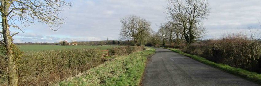
3.35 Hemswell is approached from the west by Hemswell Lane, a gently winding route edged by wide grass verges and
3.32 The final key element of Hemswell’s structure are the numerous pedestrian routes that extend outwards from low-lying hedgerows that are interspersed regularly with deciduous trees. Beyond these hedgerows lies open agricultural land
the village into the surrounding rural landscape. Often with a pleasingly rustic, rural character (Fig 48 and 49), public (mostly pastures) and extensive views across the rural landscape.
rights of way and walking trails facilitate pedestrian access into Hemswell’s immediate rural landscape and beyond.
3.36 Long views towards Hemswell on this approach are characterised by a distinct lack of built forms, with green and
3.33 Further commentary on the distinct development patterns found at different parts of Hemswell can be found in natural features dominating ones field of vision, and the village displaying a particularly verdant and wooded external
the ‘Village Character’ section. appearance, a character that extends up the scarp and provides a rustic, development-free backdrop to the village. Gaps in the
roadside planting reveal views to the south-east, which take in the more exposed expanse of the Cliff, which allow the viewer
to get a more precise understanding of the distinct gradient that characterises this landform.
3.37 Low Farm, positioned away from the road on the northern side of Hemswell Lane, is the only notable exposed built
form along this approach into Hemswell. However, rather than detract views into Hemswell, Low Farm actually makes a
positive contribution to this approach due to its handsome local vernacular aesthetic. With the rich red brick of the farmhouse,
the pale stone of the neighbouring barn, and the vivid clay pantile roofing across both buildings, Low Farm shimmers against
the darker green tones that characterise its backdrop and forms a key landmark and gateway building along this western
approach into Hemswell.
3.38 As one gets closer to Hemswell, the road begins to take on a more enclosed character, with the emergence of taller,
more dense hedgerows and a greater abundance of roadside tree planting. This enclosed character is carried through into the
village, with traditional stone walling, much of it ivy-clad and set to the fore of shrubbery and trees, creating an attractive and
well-defined edge to the roadside at the gateway. This subtle emergence of walling along the roadside begins what is a very
gentle and pleasing transition from countryside to village setting. Even from the foot of the Grade II listed Manor House, whose
grounds mark this particular gateway into Hemswell, only slight glimpses of the buildings that form the western extents of
Church Street can gained through the still copious greenery.
5
Fig 47: The row of semi-detached residences at Brook Street represent one of Hemswell’s most uniform and regimented development
arrangements, with each property following the same precise building line and orientation.
Fig 48: A network of pedestrian trails, many of a charming rural character, meander outwards into the surrounding rural landscape Fig 49 - 53: The western approach into Hemswell from along Hemswell Lane (sequence commences at the top-left image on page 26 and
from Hemswell’s built extents. ends with image above - numbering within images and directional arrows denote image sequence).
©Carroll Planning + Design 2018 Hemswell and Harpswell Character Assessment 281 2
4 3
©Carroll Planning + Design 2018 Hemswell and Harpswell Character Assessment 29Middle Street / Bunkers Hill 3.41 The sloping character of Bunker’s Hill, coupled with its distinctly straight alignment and elevated edges, draws the
eye forward and creates a perfectly framed, almost symmetrical view towards the village. Positioned centrally within this
3.39 Entering Hemswell from the east, the roadside environment is just as rural and verdant as that seen along view is the red brick facade of No.12 Wealdon Road, which provides a constant hint towards the presence of the more built
Hemswell Lane, with wide grass verges, hedgrows and mature trees lining Middle Street, which runs north-south along the up environment that lies ahead.
Cliff ridge. Exiting Middle Street and entering Bunkers Hill, a similarly green environment is presented, with sweeping grass
banks topped by trees and hedgerows characterising the roadside edges. 3.42 At the foot of Bunker’s Hill the sloping character of the route gives way to a more gentle topography, and the road
opens up to reveal a more spacious environment where Bunker’s Hill meets with Weldon Road. Marking this particular
3.40 However, it is the dramatic change in topography that is the defining characteristic of the Bunkers Hill approach into gateway is the distinct white-rendered and linear profile of Lilac Cottage, whose attractive form welcomes travellers into
Hemswell, with this relatively short route displaying a pronounced, steep incline as it falls away from the top of the Cliff. Hemswell’s south-western extents.
Indeed, Bunker’s Hill represents arguably the best location within Hemswell from which to appreciate the unique landscape
gradient that characterises the limestone escarpment.
1 2 3
5 4
Fig 54 - 58: The eastern approach into Hemswell from Middle Street and Bunkers Hill.
©Carroll Planning + Design 2018 Hemswell and Harpswell Character Assessment 30Village character
Brook Street
3.43 Brook Street forms the northern extents of Hemswell. It follows a
straight east-west alignment, which facilitates long, unbroken views along the
road. These are particularly distinct and handsome when looking eastwards
towards the Cliff, which rises up behind the village, its multiple wooded clusters
forming a picturesque backdrop to the street (Fig 59 and 60)..
3.44 Indeed, the adjoining rural landscape is an important component of
Brook Street’s character, with glimpses of the wider agricultural setting being
available through gaps between those properties that occupy its northern side,
and attractive open views out towards the immediate landscape setting (Fig 61
and 62) from either end of the street. Furthermore, direct pedestrian access into
this adjoining rural landscape is possible from Brook Street, which is bookended
by several walking trails (Fig 63 and 64) of a distinctly rural and tranquil character,
with the Beck Lane route to the west also offering some of the best views
towards the Grade II listed Manor House (Fig 65).
3.45 Development along Brook Street is arranged in a linear fashion, with
development following a broadly similar building line and spaced at relatively
regular intervals. In this regard, Brook Street represents one of Hemswell’s most
uniform and coherent parts of the village. However, the actual aesthetic of those
buildings that occupy Brook Street is less consistent, and there is a particularly
stark contrast between the northern and southern edge of this street.
Fig 61 and 62: A key component of the character of Brook Street is its strong visual
Fig 59 - 60: Looking east along Brook Street buildings appear against the striking and characterful backdrop of the Lincoln Cliff and the bands of dense tree planting that it relationship with the surrounding rural landscape, which can be appreciated at numerous
accommodates. points along the route.
©Carroll Planning + Design 2018 Hemswell and Harpswell Character Assessment 313.46 The northern side of Brook Street presents a mature,
historic area comprised of three distinct architectural groupings;
(1) No.27-35 (Fig 66-71), a trio of large two-storey buildings
positioned at the foot of the escarpment, (2) No.17-25 (Fig
72-77), a succession of several detached cottages, and (3) No.1-
15 (Fig 78 and 79), a uniform row of Inter-war semi-detached
residences.
3.47 No.27-35 enjoy a particularly appealing setting at the
bottom of the Cliff that exhibits a traditional rural character. The
properties are enclosed by handsome limestone walling topped
by upright coping stones, outside of which lies an informal
lane edged by wide grass verges and sheltered by an imposing
row of mature deciduous trees. The buildings enjoy regular
spacing and a common building line. They are of buff/brown
brick construction with red pantile roofing. All three buildings
display a similar bulk and scale but variances in roof forms and
facade arrangements gives each their own distinct identity.
Brick chimney stacks adorn the roofs of each, and these are
particularly prominent and towering at No.27-29 and No.35.
Fig 65: Though accessed from Church Street, Manor House is actually best
3.48 No.17, 19 and 21/23 Brook Street are a trio of 17th
Fig 63 and 64: From Brook Street several dedicated pedestrian routes branch out into the surrounding countryside, each appreciated from Beck Lane, which offers more immediate views towards the
century cottages coursed stone cottages with red pantile offering serene and picturesque rural walks. Grade II listed farmhouse and associated outbuildings.
roofing. Each display simple, symmetrical 3-bay facades, across
which windows are typically sliding sash or casement. Roofs
incorporate brick chimney stacks along the ridge. No.19 also
hosts two attractive outbuildings of similar aesthetic, one of
which was the former village smithy.
3.49 Positioned within the same stretch of road are No.17a
and No. 25 Brook Street. The former is a recent infill dwelling
which draws inspiration of the neighbouring 17th century
cottages, progressing a similar materials palette and replicating
their facade arrangements, though the omission of chimneys
and a slightly more substantial bulk do differentiate it from its
more authentic neighbours. No.25 Brook Street is a simple red
brick cottage that forms the street frontage to a more extensive
courtyard arrangement to its rear. Though of red brick, No.25
Brook Street still manages to sit comfortably alongside its
coursed stone neighbours due to its adoption of red pantile
roofing and its verdant and mature front gardens, which respond
positively to the wider rural aesthetic of the local environment.
3.50 Further harmonising the streetscape at No.17-25 Brook
Street is a frontage comprised of a mixture of hedgerows, brick
and stone walling, traditional timber field gates, lawned gardens
(often generously planted) and a roadside of wide grass verges,
which at the front of 21-25 Brook Street expands into an arched
green space that marks the junction with Dawnhill Lane.
3.51 The only significant detracting feature along No.17-25
Brook Street is the crude steel hoarding that runs along part of
the frontage of No.19. This makeshift boundary treatment is
completely out-of-character and disrupts the visual harmony
of the roadside environment whilst simultaneously eroding the
overall aesthetic of the host building.
3.52 No.1-15 form the remainder of Brook Street’s northern
Fig 66-71: No.27-35 Brook Street form a coherent grouping at the eastern extents of Brook Street, where they enjoy a scenic setting with a particularly rural aesthetic at the foot of the Cliff.
©Carroll Planning + Design 2018 Hemswell and Harpswell Character Assessment 32Fig 72-74: No.17, 19 and 21/23 represent Brook Street’s most characterful and historic properties. Dating from the 17th century., all three share a similar coursed stone and pantile aesthetic, and are recognised within the Hemswell Conservation Area Appraisal (1985) as ‘Buildings
of Interest’.
Fig 77: The former smithy buildings represent some of the most unique and charming
vernacular structures at Brook Street, however, the full splendour of their form cannot
Fig 75: No.17a is recent addition to the northern side of Brook Street, which replicates the Fig 76: No.25 Brook Street sits within a heavily planted plot, that includes several mature trees, be appreciated due to the presence of a rather blunt and unsympathetic boundary
vernacular aesthetic of the more historic coursed stone properties that neighbour it. and which enhances both the building itself as well as the immediate setting. treatment.
edge. They comprise 8 semi-detached dwellings set within four individual blocks, which all adhere to a consistent building
line and sit with plots of identical shape and size, creating an orderly planned character, typical of many Inter-war local
authority built schemes. Each block presents the same long, linear form, and this, coupled with their strict building line
and modest spacing, results in No.1-15 forming particularly strong frontage onto the public realm.
3.53 Each of the semi-detached dwellings at No.1-15 Brook Street display the same concise palette of materials,
namely red brick walling with red pantile roofing, and also progress identical architectural detailing and facade
arrangements. These properties, though of relatively grand scale, are modest and uncomplicated in their form and
appearance. Three red brick chimney stacks emerge from each gently curving roof pitch; one at either gable end, the
other located at the centre of the block, helping to create a particularly symmetrical composition, which is further
reinforced by the single storey lean-tos that slope away from each gable end, and by the regular positioning of
fenestration and doorways. To the front of the properties are lawns enclosed by tightly-trimmed hedgerows, whilst a
generous, almost semi-circular grass verge extends out into the street, much like that seen at the opposite end of Brook
Street outside of 21-25 Brook Street.
3.54 Though of an architectural language that is otherwise foreign to Hemswell, No.1-15 Brook Street still sit
comfortably within their setting and make a positive contribution to the village aesthetic. With their regular layout, Fig 78: The vibrant red hues of No.1-15 Brook Street contrast beautifully with the wider greenery that characterises both their private front
repeated designs, simple yet rich materials palette, and generally lush and green gardens combining to create a distinct gardens, the roadside environment, and also the agricultural landscape that provides their backdrop.
©Carroll Planning + Design 2018 Hemswell and Harpswell Character Assessment 33You can also read