Great Connell SHD, Newbridge Outline Mobility Management Plan - 192229-PUNCH-XX-XX-RP-C-0006
←
→
Page content transcription
If your browser does not render page correctly, please read the page content below

Great Connell SHD, Newbridge

Outline Mobility Management Plan
192229-PUNCH-XX-XX-RP-C-0006

April 2022
Great Connell SHD, Newbridge
                                                           Outline Mobility Management Plan

Document Control
Document Number: 192229-PUNCH-XX-XX-RP-C-0006

 Revision    Status    Description      Date       Prepared        Checked      Approved

    A0        C01      SHD Stage 3   07/04/2022    J. Fennell      J. Tiernan   J. Tiernan

192229-PUNCH-XX-XX-RP-C-0006              Page i                                  April 2022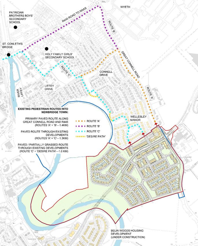
Great Connell SHD, Newbridge
                                                                                     Outline Mobility Management Plan

Table of Contents
Document Control ...................................................................................................... i
Table of Contents ...................................................................................................... 2
1.         Introduction.................................................................................................... 3
2.         Mobility Management Plan ................................................................................... 4
     2.1       Introduction ................................................................................................. 4
     2.2       Proposed Development .................................................................................... 6
     2.3       Objectives of the Plan ..................................................................................... 9
     2.4       Commuter Trends ........................................................................................ 10
     2.5       Site Location .............................................................................................. 11
3.         Site Conditions .............................................................................................. 12
     3.1       Site Access ................................................................................................ 12
     3.2       Parking ..................................................................................................... 13
       3.2.1     Car Parking ............................................................................................. 13
       3.2.2     Cycle Parking .......................................................................................... 17
     3.3       Pedestrian & Cycling Environment ..................................................................... 19
       3.3.1     Existing Pedestrian Environment & Travel Times ................................................. 22
       3.3.2     Existing Cycle Enironment & Travel Times ........................................................ 23
       3.3.3     Future Pedestrian & Cycle Environment ........................................................... 24
     3.4       Public Transport Services ............................................................................... 26
       3.4.1     Bus services - .......................................................................................... 28
       3.4.2     Bus Services – Local ................................................................................... 30
       3.4.3     Proposed Bus Stops .................................................................................... 31
       3.4.4     Train Services .......................................................................................... 33
     3.5       Taxi Services .............................................................................................. 34
     3.6       Car Sharing ................................................................................................ 35
       3.6.1     Car Pooling ............................................................................................. 35
       3.6.2     GoCar ................................................................................................... 35
4.         Implementation / Consultation / Monitoring ........................................................... 37

192229-PUNCH-XX-XX-RP-C-0006                                 Page 2                                               April 2022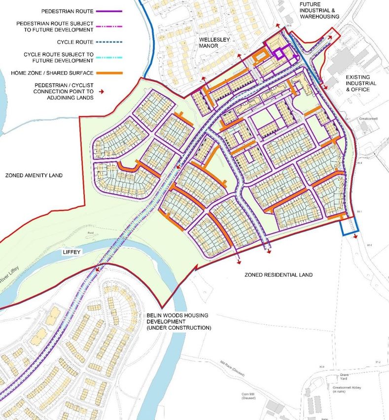
Great Connell SHD, Newbridge
                                                                      Outline Mobility Management Plan

1. Introduction
This Outline Mobility Management Plan (MMP) has been prepared to accompany a Planning Application
for a proposed residential development / strategic housing development. The proposal consists of the
construction of 569 no. dwellings, a neighbourhood centre, a childcare facility, public parks and all
ancillary works including the provision of 350 metres of the Southern Relief Road.
The application site is part brownfield/ part greenfield site with 3 no. existing buildings on the eastern
side, and the majority of the existing land used for agriculture. The proposed development is located to
the east of Newbridge town centre on the eastern side of the River Liffey. The site is within the
Newbridge Local Area Plan.
The proposed works are outlined in a series of architectural drawings prepared by OFA Architects, and
engineering drawings prepared by PUNCH Consulting Engineers that are supplied as part of the planning
documentation.

192229-PUNCH-XX-XX-RP-C-0006                     Page 3                                        April 2022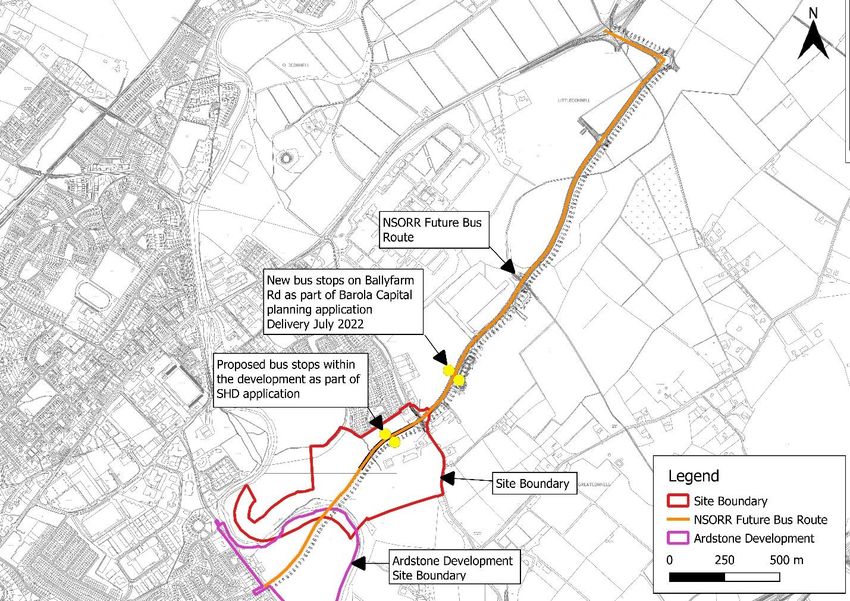
Great Connell SHD, Newbridge
                                                                      Outline Mobility Management Plan

2. Mobility Management Plan

 2.1 Introduction
This MMP has been prepared for Aston Ltd to accompany a planning application for a proposed residential
development/strategic housing development in Newbridge Co. Kildare to meet the requirement of
Section 6.9 of the 2017-2023 Kildare County Development Plan.
The applicant, Aston Ltd, recognises the need for all significant transport generators to play a role in
meeting the objectives set out in the Department of Transport Document titled “Smarter Travel: A
Sustainable Future – A new Transport Policy for Ireland 2009-2020” which sets out ambitious targets with
respect to delivery of sustainable transport modes.
This MMP therefore outlines the provisions proposed to be put in place as a means of reducing car
dependency associated with the development in the interest of compliance with the following sustainable
transport initiatives:
International:
       EU 2030 greenhouse gas reduction targets
National:
       Project Ireland 2040: National Planning Framework (NPF)
       Smarter Travel: A Sustainable Transport Future – A New Transport Policy for Ireland 2009-2020
       The National Cycling Policy Framework 2009-2020
       Sustainable Urban Housing: Design standard for new apartments guidelines for planning
       authorities (March 2018)
       National climate change strategy 2007 – 2012
Regional:
         Regional Planning Guidelines for the Greater Dublin Area 2010-2022
         Eastern and Midland Regional Spatial & Economic Strategy 2019-2031 – Proposed Newgrange to
         Newbridge Greenway
         Greater Dublin Area Cycle Network Plan 2013 (specifically the Strategic Cycle Network Plan for
         County Kildare)
         Transport strategy for the greater Dublin Area 2016 – 2035
Local:
         Kildare County Development Plan 2017 – 2023.
         Draft Newbridge Transport Plan; Provides proposals for the improvement of sustainable transport
         facilities in Newbridge.
         Kildare Co. Council Corporate Plan 2019-2024 – Strategy: “Deliver enabling infrastructure for a
         connected County”
         Newbridge 2013-2019 (extended to 2021) Local Area Plan

192229-PUNCH-XX-XX-RP-C-0006                     Page 4                                        April 2022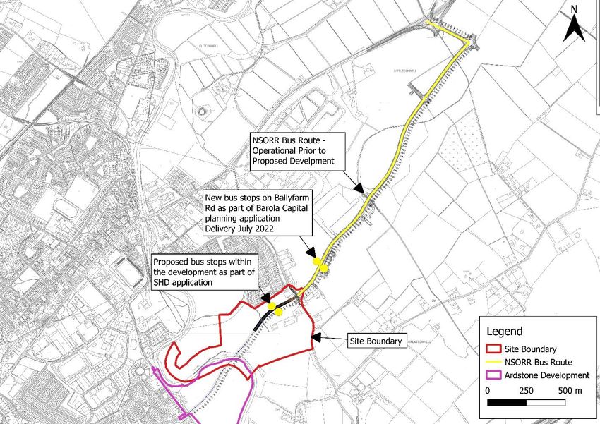
Great Connell SHD, Newbridge
                                                                       Outline Mobility Management Plan

A baseline turning count travel survey was undertaken during data collection stage. A Traffic and
Transportation Assessment was undertaken to analyse the significance of this data. This document
(192229-PUNCH-XX-XX-RP-C-0004) is included as part of the planning application for this development.
The proposals incorporate elements of the strategic vision of ‘Kildare County Development Plan 2017-
2023’ which aims to “improve sustainable mobility”. Kildare County Council is committed to the
promotion of Smarter Travel mobility targets, through various measures outlined herein.
MMPs are developed for enhancing travel via more sustainable modes of transport. MMPs are conducted
to identify travel demand strategies to reduce single occupancy private car travel which in turn reduces
traffic congestion, noise pollution and environmental impacts. Residents and users of the site are
informed of the alternatives to the private car and are given the required advice, support and
encouragement to travel in a sustainable way. The MMP will also include proposed future transport
improvements to those already available, including walkways, cycleways, public transport and future
extended infrastructure.
For this development, a site-specific MMP can only be fully developed and implemented once the
occupier/user and their travel behaviour are known, and when the development is occupied. This outline
MMP sets out the key infrastructural proposals and modal split targets for the development in general
terms and will be further developed when the development is occupied.
The MMP should be considered as a dynamic process where a package of measures and campaigns are
identified, piloted and monitored on an ongoing basis. The nature of the plan therefore changes during
its implementation in that some measures prove successful and are therefore retained while others are
not supported and are discarded. It is important that the plan retains the support of users and receives
continuous monitoring. Feedback and active management of the plan is required for it to continue to be
successful.
The MMP specific to the nature and location of the development will consist of a package of sustainable
measures aimed at increasing sustainable travel. These measures can include facilitating walking, cycling
and car sharing schemes. Soft measures such as education, information and awareness can also be used.
The MMP will be developed once the development is fully occupied.
The new development will cater for both vehicular and pedestrian traffic and includes provision of
bicycle parking. Measures laid out in the outline MMP will aim to reduce the number of people travelling
to and from the development by car, promote the use of public transport and encourage users to use
more sustainable methods of travelling.
In order to establish an effective MMP, the development once occupied should submit the following
information:
        1. Residents travel survey information to establish the origin and destination of trips to and
           from the development,
        2. Outline specific schemes/measures implemented to encourage a shift from car dependant
           transport to and from the site
        3. Results of resident’s comments
        4. Targets to be set out in accordance to approved NTA guidelines and documents
        5. An outline of the various schemes that the development plan to make available to its
           residents to encourage the desired change in their travel patterns to and from work; such
           as shared parking facilities, cycle facilities, public transport subsidies, car-pooling, walking
           groups, cycle groups, communication, consultation, promotion and tax saver schemes.
The success of the MMP depends on the co-operation of all parties. The appointment of a co-ordinator
and a steering group is vital for the success of the plan. This MMP will need to be reviewed on a regular
basis within the steering group with updates occurring as improvements to the transport network in the
vicinity of the development site are implemented.

192229-PUNCH-XX-XX-RP-C-0006                      Page 5                                         April 2022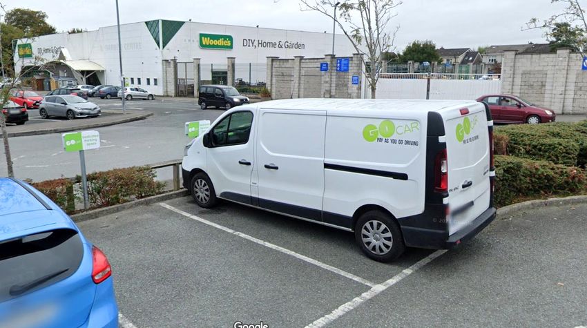
Great Connell SHD, Newbridge
                                                                      Outline Mobility Management Plan

 2.2 Proposed Development
Aston Limited intend to apply to An Bord Pleanála for permission for a strategic housing development at
this site at Great Connell, Newbridge, County Kildare. This subject site comprises the lands surrounding
and including the dwellings of ‘Greatconnell’ and ‘Valencia Lodge’, Great Connell, Newbridge, Co.
Kildare, Eircodes: W12 TW29 and W12 V382.
The development will consist of the demolition of existing site structures (2,622.3 sqm) and the
construction of 569 no. residential units, a neighbourhood centre with 11 no. units (commercial floor
area 2,141 sqm) and a childcare facility (886 sqm), a circa 350 metre section of distributor road, and all
ancillary and associated works on a site of 27.64 ha. The proposed development comprises:

    1.       Demolition of existing site structures (total 2,622.3 sqm) comprising; ‘Great Connell’ a two-
             storey dwelling of 331.9 sqm with detached single storey garage and outhouses of 48 sqm;
             ‘Valencia Lodge’ a single storey dwelling of 135.6 sqm with a single storey garage of 17.8
             sqm; two no. single storey sheds of 1,440 sqm and 595 sqm, and a three-sided shed of 54
             sqm.
    2.       Construction of 569 no. new residential dwellings (325 no. houses and 244 no. apartments)
             comprising:
         •        64 no. two-bed houses; 173 no. three-bed houses; and 88 no. four-bed houses (ranging
                  in height from 2 to 3 storeys).
         •        Apartment Block A (Part 3 and 4 Storeys): 5 no. one-bed apartments; 14 no. two-bed
                  apartments; and 3 no. three-bed apartments. These proposed units have private
                  balconies or terraces, and access to a community roof terrace of 112.4 sqm.
         •        Apartment Block B (Part 3 and 4 Storeys): 5 no. one-bed apartments; 14 no. two-bed
                  apartments; and 3 no. three-bed apartments. These proposed units have private
                  balconies or terraces, and access to a community roof terrace of 112.4 sqm.
         •        Apartment Block C (Part 3 and 4 Storeys): 4 no. one-bed apartments; 19 no. two-bed
                  apartments and 4 no. three-bed apartments. These proposed units have private balconies
                  or terraces, and access to a community roof terrace of 87 sqm.
         •        13 no. apartments above the proposed Neighbourhood Centre comprising; 4 no. own-
                  door two-bed apartments; 3 no. shared-access one-bed apartments; and 6 no. shared-
                  access two-bed apartments. These proposed units have private balconies or terraces.
         •        160 no. own-door apartments in 2- and 3- storey buildings comprising; 16 no. one-bed
                  apartments; 78 no. two-bed apartments, 66 no. three-bed duplex apartments. These
                  units will have private amenity areas in the form of terraces, balconies and/or rear
                  gardens.
    3.       Provision of Neighbourhood Centre (ranging in height between 2 and 4 storeys) with 11 no.
             commercial units comprising: a convenience shop of 909 sqm (unit 1); 3 no.
             doctor/dentist/physio units of 120 sqm, 120 sqm and 90 sqm (units 6, 7, and 8, respectively);
             a café of 125 sqm (unit 4); a restaurant of 213 sqm (unit 9); and 5 no. shop/convenience
             services units of 112 sqm, 49 sqm, 171 sqm, 100sqm and 100 sqm (units 2, 3, 5,10 and 11,
             respectively). The proposed Neighbourhood Centre includes an external roof terrace of 176
             sqm.
    4.       Provision of a childcare facility (886 sqm) within the Neighbourhood Centre with capacity for
             in the order of 154 no. children.
    5.       Provision of 1,008 no. car parking spaces comprising 650 no. spaces for the proposed houses;
             312 no. spaces for the proposed apartments; and 46 no. spaces to serve the Neighbourhood
             Centre.
    6.       Provision of 732 bicycle parking spaces comprising 536 no. secure residential spaces, 134 no.
             residential visitor spaces, and 62 no. spaces to serve the Neighbourhood Centre.

192229-PUNCH-XX-XX-RP-C-0006                      Page 6                                       April 2022
Great Connell SHD, Newbridge
                                                                   Outline Mobility Management Plan

   7.     A series of 18 no. public open spaces and pocket parks are proposed throughout the
          residential development (2.613 ha net area).
   8.     Provision of an 8.31 ha amenity area adjoining the River Liffey.
   9.     Vehicular access to the proposed development from Great Connell Road via a circa 350 metre
          section of the Newbridge South Orbital Relief Road (NSORR), including footpaths and cycle
          paths. It is proposed to upgrade the existing Great Connell Roundabout to a signalised
          junction and provide footpaths and cycle paths within the subject site along the Great
          Connell Road.
   10.    Proposed development facilitates future potential pedestrian, cycle and vehicular links to
          adjoining residential development and undeveloped lands.
   11.    All enabling and site development works, landscaping, boundary treatments, lighting,
          services and connections, including connection to permitted wastewater pumping station,
          waste management, ESB substations, compensatory flood storage and all other ancillary
          works above and below ground on a site of 27.64 ha.
   12.    A 7 year permission is sought.

   The proposed development will deliver approximately 350m of the Newbridge Southern Outer Orbital
   Relief Road (NSORR) from Great Connell Roundabout to the furthest access point within the
   development site along the new road. The NSORR splits the proposed development into two distinct
   sections, north and south.
   A bridge over the River Liffey is required to complete the NSORR delivery in accordance with the
   requirements of the Newbridge Local Area Plan which will tie in with the section of the NSORR to be
   delivered under Planning Reference: ABP-302141-18, on the western side of the River Liffey. Aston
   Ltd has commenced the planning process with Kildare County Council to deliver this final road and
   bridge connection of the NSORR under a separate planning application (Section 247 Kildare County
   Council Consultation Reference: PP2559). Aston Ltd has taken on this element of works in order to
   expediate the approval process and ensure that the connection can be made in a shorter timeframe
   than if Kildare County Council were to progress under public procurement.
   The proposed layout for the development is detailed in the series of drawings by OFA Architects
   accompanying this report and an extract is included in Figure 2-1.

192229-PUNCH-XX-XX-RP-C-0006                   Page 7                                      April 2022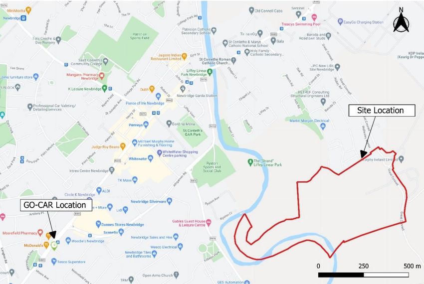
Great Connell SHD, Newbridge
                                                                                Outline Mobility Management Plan

                       Figure 2-1: Extract from Architect’s Site Layout Plan

192229-PUNCH-XX-XX-RP-C-0006                 Page 8                            April 2022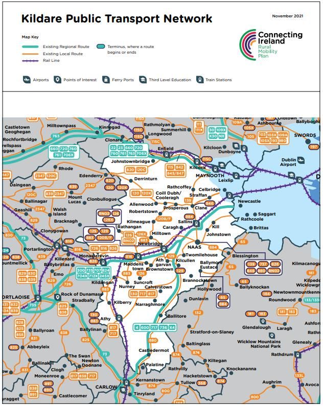
Great Connell SHD, Newbridge
                                                                   Outline Mobility Management Plan

 2.3 Objectives of the Plan
This Plan outlines the provisions that the applicant proposes to put in place as a means of promoting
sustainable transport, active travel and reducing car dependency associated with the development, in
the interest of compliance with the following sustainable transport initiatives:
 •    The need to reduce transport emissions to meet EU 2030 greenhouse gas reduction targets;
 •    Project Ireland 2040: National Planning Framework (NPF)
 •    Department of Transport national policy, Smarter Travel: A Sustainable Transport Future – A New
      Transport Policy for Ireland 2009-2020
 •    The National Cycling Policy Framework 2009
 •    Sustainable Urban Housing: Design standard for new apartments guidelines for planning
      authorities (March 2018)
 •    National climate change strategy 2007 – 2012
 •    Regional Planning Guidelines for the Greater Dublin Area 2010-2022
 •    Eastern and Midland Regional Spatial & Economic Strategy 2019-2031 – Proposed Newgrange to
      Newbridge Greenway
 •    Greater Dublin Area Cycle Network Plan 2013 (specifically the Strategic Cycle Network Plan for
      County Kildare)
 •    Transport strategy for the greater Dublin Area 2016 – 2035
 •    Kildare County Development Plan 2017 – 2023.
 •    Draft Newbridge Transport Plan; Provides proposals for the improvement of sustainable transport
      facilities in Newbridge.
 •    Kildare Co. Council Corporate Plan 2019-2024 – Strategy: “Deliver enabling infrastructure for a
      connected County”
 •    Newbridge 2013-2019 (extended to 2021) Local Area Plan

The objectives of the MMP for the proposed development are as follows:
           a) To encourage/increase the use of public transport for residents and visitors for work-
              related travel and to facilitate travel by bicycle, bus and train.
           b) To encourage/increase sustainable modes of transport by providing integrated
              pathways for walkers and cyclists.
           c) To reduce the overall number of single occupant vehicles trips for journeys to and from
              the development.
           d) To integrate mobility management into the development decisions, policies and
              practices to work closely with governing bodies on means and use of transport services
              around the vicinity of the development site.
           e) To provide information and have resources readily available to increase awareness and
              continue education on sustainable modes of travel for both residents and visitors to the
              development.
           f) To increase car-pooling amongst residents and staff in the neighbourhood centre.
           g) Connection to the existing network so as to provide more sustainable modes of travel
              and modes of transport to the Newbridge town and local schools.
           h) Provide accessibility for sustainable modes of travel to places of work, education,
              healthcare, leisure, recreation and shopping, thus reducing dependency on private car
              use.
           i) Identify amenities within the development such as open park landscaping and the
              inclusion of recreation sports field and neighbourhood centre.
           j) Identify potential employment hubs and accessibility to such.

192229-PUNCH-XX-XX-RP-C-0006                   Page 9                                       April 2022
Great Connell SHD, Newbridge
Outline Mobility Management Plan
2.4 Commuter Trends
Based on the 2016 Census, it is evident that a significant percentage of residents in the area do not own
a car (9%) or own a single car (38%) as shown below in Figure 2-2. Residents are thus likely to travel to
work, school or college by walking, cycling and public transport (29%), Motor car usage for both driver
and passenger-shared accounts for much of the remainder (61%). Please see Figure 2-2 and Figure 2-3
from Central Statistics Office below.
Figure 2-2: Census 2016 Commuting in Ireland - Table EZ047 (Ref: EZ047 - Private Households in Permanent
Housing Units 2011 to 2016 (cso.ie))
Figure 2-3: Census 2016 Commuting in Ireland - Table E6011 (E6011 - Population Usually Resident and Present
in the State 2011 to 2016 (cso.ie))
192229-PUNCH-XX-XX-RP-C-0006 Page 10 April 2022Great Connell SHD, Newbridge
Outline Mobility Management Plan
2.5 Site Location
The application site is part brownfield/ part greenfield site with 3 no. existing buildings on the eastern
side, and the majority of the existing land used for agriculture. The proposed development is located to
the east of Newbridge town centre on the eastern side of the River Liffey. The site is within the
Newbridge Local Area Plan. Refer to Figure 2-4 below. The site is approximately 2km from Newbridge
Town (St Conleth’s Bridge), 2.9km from Newbridge Train Station and approximately 4.9km from the
Newbridge/M7 junction. Distances are taken from the proposed site entrance on Great Connell Road.
There are three existing access points onto the site from Great Connell Road to the east.
The proposed site is bounded by the existing Wellesley Manor residential developments to the north-
east, Great Connell Road to the east and existing farmland to the south. The River Liffey and existing
farmland are located to the west. Ardstone Limited were granted planning for 343 residential units on
the site located on the western side of the River Liffey under planning approval grant ABP-302141-18.
This development is now under construction. Aston Ltd has commenced the planning process with Kildare
County Council to deliver the road and bridge connection of the NSORR over the River Liffey under a
separate planning application (Section 247 Kildare County Council Consultation Reference: PP2559).
Aston Ltd has taken on this element of works in order to expediate the approval process and ensure that
the connection can be made in a shorter timeframe than if Kildare County Council were to progress under
public procurement. Once delivered under Kildare County Council Roads Objective, the NSORR will link
the proposed Aston development with the Ardstone development via a proposed bridge over the River
Liffey.
Murphy International Limited headquarters/offices are located adjacent the site on the eastern side of
Great Connell Road. Pfizer Pharmaceutical, Lidl Distributer Warehousing as well as planning approval for
Barola regional distribution centre are potential employment areas all located within close proximity to
the site.
Figure 2-4: Site Location Plan (Ref: https://www.openstreetmap.org/#map=14/53.2652/-6.1863)
192229-PUNCH-XX-XX-RP-C-0006 Page 11 April 2022Great Connell SHD, Newbridge
Outline Mobility Management Plan
3. Site Conditions
This section gives an overview of the accessibility of the options for travel associated with the proposed
housing development.
3.1 Site Access
Vehicular access to the site is via Great Connell Road Roundabout to the east which has a 60 km/hr speed
limit. It is proposed to signalise this existing roundabout as part of the proposed development.
The proposed development will deliver approximately 350m of the Newbridge Southern Outer Orbital
Relief Road (NSORR) from Great Connell Roundabout to the furthest access point within the development
site along the new road. The NSORR splits the proposed development into two distinct sections, north
and south.
A bridge over the River Liffey is required to complete the NSORR delivery in accordance with the
requirements of the Newbridge Local Area Plan which will tie in with the section of the NSORR to be
delivered under Planning Reference: ABP-302141-18, on the western side of the River Liffey. Aston Ltd
has commenced the planning process with Kildare County Council to deliver this final road and bridge
connection of the NSORR under a separate planning application (Section 247 Kildare County Council
Consultation Reference: PP2559). Aston Ltd has taken on this element of works in order to expediate the
approval process and ensure that the connection can be made in a shorter timeframe than if Kildare
County Council were to progress under public procurement.
The Great Connell Road is a Local Primary Road linking the R445 with the L2032. Great Connell Road is
a single lane two-way carriageway with a footpath generally only on the western side of the road.
North of the roundabout the road provides access to a number of residential estates and Newbridge town,
and east of the roundabout provides access to employment centres such as the Lidl Distribution Centre
and Murphy International Limited headquarters/offices from Ballyfarm Road which forms part of the
NSORR. Pfizer Pharmaceutical as well as planning approval for Barola regional distribution centre are
additional potential employment areas all located within close proximity to the site.
192229-PUNCH-XX-XX-RP-C-0006 Page 12 April 2022Great Connell SHD, Newbridge
Outline Mobility Management Plan
3.2 Parking
3.2.1 Car Parking
Car parking serving the apartments in the development is provided in accordance with the guidance for
Peripheral and/or Less Accessible Urban Locations in the Design Standards for New Apartments (2018)
section 4.22. Car parking serving the houses, creche and neighbourhood/commercial centre are provided
in accordance with the Kildare County Council Development Plan (2023) ‘Table 17.9’ as shown below in
Figure 3-1. The Kildare County Council Development Plan standards indicate the recommended parking
for residential premises and the maximum permissible spaces for all other developments.
The applicable car parking standards are noted in the tables below:
Figure 3-1: Table 17.9 from the Kildare County Council Development Plan 2023
192229-PUNCH-XX-XX-RP-C-0006 Page 13 April 2022Great Connell SHD, Newbridge
Outline Mobility Management Plan
Table 3-1: Design Standards for New Apartments: Peripheral and/or Less Accessible Urban Locations
Car Parking Requirement
No. of Total
Development type GFA m2 Requirement Total
Units Provided
1 space per unit + 1 visitor
Apartment - 244 304 312
space per 4 units
Total 304 312
Table 3-2: Kildare County Council Development Plan Car Parking Requirement for Houses
No. of Total
Development type GFA m2 Requirement Total
Units Provided
House - 325 2 spaces per unit 650 650
Table 3-3: Summary Car Parking Requirement for Residential
Development type Total Required Total Provided
Residential 955 962
Table 3-4: Kildare County Council Development Plan Car Parking Maximum for Neighbourhood Centre
GFA No. of Units Total Total
Neighbourhood Centre Maximum Provision
m2 / Children Maximum Provided
10 staff
0.5 per staff member
Creche - 43
plus 1 per 4 children
154 children
1 space per 20 sq.m
Convenience (unit 1) 909 - 45
gross floor area
1 space per 20 sq.m 46
Convenience (units 2,3,5,10,11) 532 - 27
gross floor area
Clinic / Group Medical Practices 5 consulting 2 spaces per consulting
330 10
(Doctor/Dentist/Physio units 6,7,8) rooms room
Café & Restaurant (units 4 & 9) 338 - 1 space per 10 sq.m 34
Total 159 46
Table 3-5: Summary Car Parking Provision for Proposed Development
Development type Total Provided
Residential 962
Commercial 46
Total 1,008
192229-PUNCH-XX-XX-RP-C-0006 Page 14 April 2022Great Connell SHD, Newbridge
Outline Mobility Management Plan
It is proposed to provide 1,008 car parking spaces on the development site, which is slightly lower than
the combined max requirements of the above tables of 1,113 spaces. The full designation of residential
car parking will be provided for each house/apartment.
The Kildare County Council development plan allows for a maximum 159 no. spaces at the neighbourhood
centre. The 46 no. proposed spaces satisfy 29% of the maximum requirement which is in accordance with
the Development Plan guidance stating that this maximum should not be a target figure.
This car parking provision is aimed at reducing the additional traffic loading in the area and is deemed
appropriate at the neighbourhood centre for the following reasons:
1. The variety of sustainable travel options available for the local residents; such as walking or
cycling within and surrounding the development.
2. The nature of the uses of the site and likely durations of stays.
3. The proximity to both the proposed and existing housing in the locality and the nearby
industrial and warehousing zoning within walking / cycling distance.
4. The abundant pedestrian and cyclist linkages to the proposed and existing developments.
The car parking area around the neighbourhood centre will have a number of shared spaces for each use.
The breakdown of car parking allocation is displayed on architectural drawing PA-011.
The ‘standard’ parking spaces will be demarcated with white lines. All car parking spaces will be 2.5m
by 5m, with disabled spaces providing an additional width and length of 1.2m.
A number of “non-standard” spaces are provided at the neighbourhood centre as shown below in Figure
3-2.
• 1 no. space will be allocated for car sharing such as GoCar to facilitate short term and or
occasional car users. Refer to Section 3.7 for further information.
• 5% of the total number non-residential spaces will be designated disabled user car-parking
spaces. The disabled spaces are to be demarcated with yellow lines, a protected hatched
area and appropriate road markings to identify these spaces. The proposed location of the
disabled parking spaces will be in close proximity to the building entrances. 4 no. disabled
spaces shall be provided.
• Electric Vehicle Charging Points (EVCP) will be provided for as per the Kildare County
Council Development Plan standards i.e.10%. through the provision of 5no. spaces. All
houses shall be provided with electric vehicle charging points.
192229-PUNCH-XX-XX-RP-C-0006 Page 15 April 2022Great Connell SHD, Newbridge
Outline Mobility Management Plan
EV parking
Disabled Parking
Car Sharing Space
Figure 3-2: Extract from architectural site layout showing non-standard parking provision neighbourhood
centre
192229-PUNCH-XX-XX-RP-C-0006 Page 16 April 2022Great Connell SHD, Newbridge
Outline Mobility Management Plan
3.2.2 Cycle Parking
Cycling is to be significantly encouraged as part of the development. Cycle parking serving the proposed
development is provided in accordance with the Kildare County Council Development Plan ‘Table 17.10.
The applicable cycle parking standards are noted in Table 3-6 below;
Table 3-6: Kildare County Council Cycle Parking Space Requirements
GFA No. of Units Total Total
Neighbourhood Centre Minimum Provision
m2 / Children Minimum Provided
10 staff
1 space per 5 staff +
Creche - 17
1 space per 10 children
154 children
1 space per 100 sq.m
Convenience (unit 1) 909 - 9
gross floor area
1 space per 2 car 62
Convenience (units 2,3,5,10,11) 532 - 14
spaces
Clinic / Group Medical Practices 5 consulting 1 per 5 staff + 0.5 per
330 5
(Doctor/Dentist/Physio units 6,7,8) rooms consulting room
1 space per 30 sq.m
Café & Restaurant (units 4 & 9) 338 - 7
public floor space
Total 52 62
Cycle parking serving the apartments in the development is provided in accordance with the Design
Standards for New Apartments (2018) section 4.17.
Table 3-7: Design Standards for New Apartments: Peripheral and/or Less Accessible Urban Locations
Cycle Parking Requirement
Residential
Visitor
requirement No of No of Residential Visitor
Unit type requirement
per units bedrooms requirement requirement
per unit
bedroom
1 bed
1 0.5 17 17 17 9
Apartment
2 bed
1 0.5 135 270 270 68
Apartment
3 bed
1 0.5 76 228 228 38
Apartment
Totals 228 505 515 115
Total Apartment Requirement 630
192229-PUNCH-XX-XX-RP-C-0006 Page 17 April 2022Great Connell SHD, Newbridge
Outline Mobility Management Plan
As shown in Table 3-8 below, A surplus of 50 excess cycle parking spaces has been provided in line with
a reduction in car parking (where permissible) within the development to help encourage modal shift.
Table 3-8: Summary Cycle Parking Provision for Proposed Development
Long Stay (Secure) Short Stay Total
Development type Total Required
Provided Provided Provided
Apartments 536 134 670 630
Commercial 40 35
Creche 22 17
Total 732 682
An extract from the site masterplan in Figure 3-3 below, showing the distribution of cycle parking
throughout the development.
Cycle parking
Figure 3-3: Distribution of proposed cycle parking throughout the development. (Extract from site layout
masterplan drg. PR-002U)
192229-PUNCH-XX-XX-RP-C-0006 Page 18 April 2022Great Connell SHD, Newbridge
Outline Mobility Management Plan
3.3 Pedestrian & Cycling Environment
As the potential for pedestrian and cycle trips to and from the development is high, it is important that
the development is properly integrated into the existing footpath, cyclepath and road network. To this
end, there are plans to provide public footpaths and cyclepaths within the site, which will connect to
existing network to the north and east on Great Connell Road and the NSORR.
In addition to direct pedestrian routes from the development to/from surrounding areas, the pedestrian
network also provides routes to/from surrounding public transport network, including nearby bus stops
and Newbridge train station on the R416.
It is proposed to upgrade the existing Great Connell Roundabout to a signalised junction with toucan
crossings. This will improve safety for pedestrians and cyclists at the main entrance to the development.
The proposed development will deliver approximately 350m of the Newbridge Southern Outer Orbital
Relief Road (NSORR) from Great Connell Road to the furthest access point within the development site
along the new road. The extended road and bridge which Aston Limited is progressing under a separate
application with Kildare County Council will allow for an alternative cycle route to Newbridge town
centre. The proposed road and bridge application will link to Ardstone Planning application (Planning
Reference: ABP-302141-18) and provide for designated footpaths and cycle lanes and allow for an
alternative route to Newbridge town centre.
It is also proposed to improve both pedestrian and cyclist permeability with Wellesley Manor housing
development north of the proposed site. This is shown in Figure 3-4.
There are existing newly constructed high quality cycle lanes and footpaths on the completed section of
the NSORR to the east of the site on Ballyfarm Road which connect to the R445 at the Lidl Distributor
Roundabout. This cycle lane and footpath is to be continued along the extent of the site frontage where
it will be possible to connect to/from neighbouring “New Residential” lands and connect into the existing
public footpath in front of Wellesley Manor. Within the development, there is a combination of shared
surfaces and designated cycle lanes to allow ease of movement for cyclists.
At the time of writing, there are a number of temporary cycle lanes within the town centre. The 2017-
2029 Kildare County Development Plan, Section 15.8.7 provides long term plans for Street Hierarchy,
providing for a safer “environment for pedestrians and cyclists” throughout the city.
192229-PUNCH-XX-XX-RP-C-0006 Page 19 April 2022Great Connell SHD, Newbridge
Outline Mobility Management Plan
ARDSTONE / GLEANVEAGH
DEVELOPMENT
Figure 3-4: Pedestrian and Cycle Key Map (Extract from Architectural Design Statement)
192229-PUNCH-XX-XX-RP-C-0006 Page 20 April 2022Great Connell SHD, Newbridge
Outline Mobility Management Plan
ST CONLETHS &
MARYS CATHOLIC
NATIONAL SCHOOL
PATRICIAN CATHOLIC
PRIMARY SCHOOL
ARDSTONE / GLEANVEAGH
DEVELOPMENT
Figure 3-5: Existing pedestrian connection to town centre key map (Extract from Architectural Design
Statement)
192229-PUNCH-XX-XX-RP-C-0006 Page 21 April 2022Great Connell SHD, Newbridge
Outline Mobility Management Plan
3.3.1 Existing Pedestrian Environment & Travel Times
The proposed permeability with the existing Wellesley Manor housing development located to the north
of the site shall provide significant reduction in walking and cycling times to the town centre. For the
purpose of this assessment, distances from the site boundary to St Conleth’s bridge were assessed using
existing routes and existing desire path routes. St Conleth’s bridge represents a focal point for the 4 no.
schools as shown in Figure 3-5: . Table 3-9 below outlines walking times from each of the site connection
points to St Conleth’s bridge.
Table 3-9: Pedestrian Route Options to St Conleth’s Bridge
Time Taken
Site Entrance to St Conleth’s Bridge Distance
(minutes)
(km) Walk
Route A + B (footpath) 1.4 17
Route A + C (footpath) 1.3 15
Route C + Desire paths (footpath & grass paths) 1.0 10
Table 3-10 below shows pedestrian travel times to other points of interest using the shortest route
possible (Route C + Desire Paths).
Table 3-10: Pedestrian Distances to Newbridge Town Locations
Time Taken
Destination Distance
(minutes)
(km) Walk
Newbridge Post Office 1.5 16
Newbridge Shopping Centre 2.1 24
Newbridge Train Station 2.4 28
192229-PUNCH-XX-XX-RP-C-0006 Page 22 April 2022Great Connell SHD, Newbridge
Outline Mobility Management Plan
3.3.2 Existing Cycle Enironment & Travel Times
Shown below are options for cyclists to cycle from the site connection points to St Conleth’s Bridge.
These routes follow footpaths and desire paths, similar to the pedestrian routes, as shown above in Figure
3-5.
Depending on the nature of the cyclist, the route and speed at which they will travel shall dictate the
route chosen. For example, a primary school student cycling alone or with their family is likely to avoid
the busy traffic on the Great Connell and Naas Roads. They are likely to be the slowest of all potential
cyclists and may take the shortest possible route via a combination of shared footpaths and desire paths
shown in Figure 3-5 above. However, a regular commuter is capable of cycling much faster and is likely
to cycle alongside traffic on the carriageway on Great Connell and Naas roads. Below are examples of
some categories of cyclists and the potential routes they would take. The time taken in Table 3-12 is
based on an average cycle speed of approximately 20 km/hr and the shortest possible route.
Table 3-11: Cyclist Speed Vs Route Chosen
Cyclist Type Cycle Speed Likely Cycle Route
Primary School Student Slow (10-15 km/hr) Route C or A+C
Secondary School Student Medium (20 km/hr) Any combination
Worker / Regular Commuter Fast (25-30 km/hr) Route A + B
Table 3-12: Cycle Route Options
Time Taken
Site Entrance to St Conleth’s Bridge Distance
(minutes)
(km) Cycle
Route A + B (footpath or carriageway) 1.4 4
Route A + C (footpath or carriageway) 1.3 4
Route C + Desire paths (footpath / carriageway & grass
1.0 3
paths)
Table 3-13: Cycle Distances to Newbridge Town Locations
Time Taken
Destination Distance
(minutes)
(km) Cycle
Newbridge Post Office 1.5 6
Newbridge Shopping Centre 2.1 8
Newbridge Train Station 2.4 10
192229-PUNCH-XX-XX-RP-C-0006 Page 23 April 2022Great Connell SHD, Newbridge
Outline Mobility Management Plan
3.3.3 Future Pedestrian & Cycle Environment
The proposed development will deliver a section of the Newbridge Southern Outer Orbital Relief Road
(NSORR) from Great Connell Road to the furthest access point within the development site along the new
road. Under Planning Reference: ABP-302141-18, a further 250m of the NSORR is proposed on the western
side of the River Liffey. The remainder of the NSORR delivery is being progressed by Aston Ltd as part of
a separate planning application (Section 247 Kildare County Council Consultation Reference: PP2559).
Aston Ltd has taken on this element of works in order to expediate the approval process and ensure that
the connection can be made in a shorter timeframe than if Kildare County Council were to progress under
public procurement. These two elements together will enable the completion of the NSORR objective
identified in the Newbridge LAP.
This future proposal includes for access along the river linear park with direct access to St Conleth’s
Bridge as shown in Figure 3-7 below. This will provide an alternative means of access to both national
and secondary schools and to Newbridge town centre.
The National Transport Authority, Greater Dublin Area Cycle Network Plan provides a proposed network
for Newbridge. An extract from this is shown in Figure 3-6.
Figure 3-6: Proposed cycle routes as part of the Greater Dublin Area Cycle Network Plan (Ref:
https://www.nationaltransport.ie )
As can be seen from Figure 3-6, there are no proposed cycle routes along Great Connell Road, however
it is planned to provide high quality segregated cycle tracks as part of the NSORR Roads Objective which
will provide additional cyclist connectivity for the proposed development.
192229-PUNCH-XX-XX-RP-C-0006 Page 24 April 2022Great Connell SHD, Newbridge
Outline Mobility Management Plan
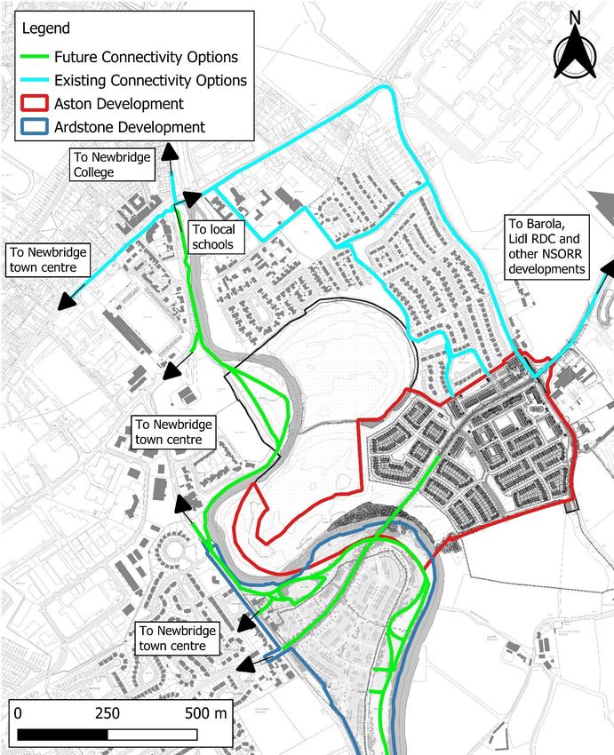
Figure 3-7: Future External Connectivity Options
It is a recommendation of this MMP that the appointed mobility manager for the development liaise with
Kildare County Council on the formalisation of these routes, to improve the quality of pedestrian and
cyclist permeability, both between and through the existing and proposed developments.
192229-PUNCH-XX-XX-RP-C-0006 Page 25 April 2022Great Connell SHD, Newbridge
Outline Mobility Management Plan
3.4 Public Transport Services
Table 3-14 below details the approximate distance and different times to travel for the main existing
transport interchanges from the development site as shown below in Figure 3-8. Note that all car
distances are taken from the site entrance, whereas walking and cycling distances may be shorter and
the distances and times shown are via the shortest possible route.
Table 3-14: Approximate Transport times from the Proposed Development Site
Description Mode – Distance – Time
Car Cycle Walk
Distance Time Distance Time Distance Time
(km) (min) (km) (min) (km) (Min)
Ballyfarm Road Bus Stop
0.2Great Connell SHD, Newbridge
Outline Mobility Management Plan
Figure 3-9: Proposed bus stop locations on site and by Barola Capital
192229-PUNCH-XX-XX-RP-C-0006 Page 27 April 2022Great Connell SHD, Newbridge
Outline Mobility Management Plan
3.4.1 Bus services -
As highlighted earlier, the following bus stops are located within close proximity to the proposed site.
See Figure 3-10 for an extract of Kildare’s public transport network.
These bus stops are serviced by the following providers;
GoAhead Commuter (Stops no. 103891, 103911, 103921, 104111, 104141, 104121, 104131,)
Route 120B: Dublin – Newbridge
Route 120F: Dublin – Newbridge
Route 125: University College Dublin – Newbridge (Opp. Ryans Bar
Route 126: Dublin - Rathangan
Route 126A: Dublin - Rathangan
Route 126B: Kildare - Dublin
Route 126D: Dublin – Newbridge
Route 126E: Kildare – Dublin
Route 126T: Dublin – Newbridge
Route 126U: Kildare – University College Dublin
Route 126X: Dublin – Rathangan
Kayanitedale Ltd (Stops no. 103891, 103911, 103921, 104111, 104121, 104141)
Route 826: Monasterevin – Naas General Hospital
Keneally’s Bus Service (Stops no. 103911, 103921)
Route 129: Newbridge – Kilcullen
Dublin Coach (Stops no. 103891, 103921, 104111, 10412, 104131, 104141)
Route 726: Portlaoise – Dublin Airport
Route 126X Dublin – Rathangan
192229-PUNCH-XX-XX-RP-C-0006 Page 28 April 2022Great Connell SHD, Newbridge
Outline Mobility Management Plan
Figure 3-10: Kildare Public Transport Network (Ref: https://www.nationaltransport.ie )
192229-PUNCH-XX-XX-RP-C-0006 Page 29 April 2022Great Connell SHD, Newbridge
Outline Mobility Management Plan
3.4.2 Bus Services – Local
In order to facilitate the use of public transport, consideration will be made to provide information on
location of stops, routes, timetables, walking times to main public transport facilities, etc. Also, to
advise residents of the availability of the national TaxSaver Scheme refer to Transport for Ireland web
site (https://www.transportforireland.ie/fares/taxsaver/) for more details. High frequency public
transport is available in the area of the development, as described below and shown above in Figure
3-10.
The development is served by TFI Local Link bus services as shown below in Figure 3-11.
Figure 3-11: Local Link Transport Network (Ref: https://www.transportforireland.ie )
192229-PUNCH-XX-XX-RP-C-0006 Page 30 April 2022Great Connell SHD, Newbridge
Outline Mobility Management Plan
3.4.3 Proposed Bus Stops
There are 2no. Bus Stops proposed within the development to connect the site to the local public
transport network.
Bus Stops
Figure 3-12: Proposed bus stop location within the proposed development
There is an additional new bus stop planned in a separate planning application for the proposed regional
distribution centre by Barola Capital, as shown in Figure 3-8 on Ballyfarm Road, located approximately
200m from the entry to Aston SHD on the NSORR. This proposed bus stop and associated routes will be
open prior to commencement of construction works associated with this planning application and are
due to be built by June 2022. Once operational this will ensure travel to and from the proposed
development site is conveniently accessible. As demonstrated within the TTA, the section of the NSORR
(Ballyfarm Rd) will be open prior to the commencement of the proposed development, Q2 2022.
The proposed development will deliver a section of the Newbridge Southern Outer Orbital Relief Road
(NSORR) from Great Connell Road to the furthest access point within the development site along the new
road. The remainder of the NSORR delivery is being progressed by Aston Ltd as part of a separate
planning application (Section 247 Kildare County Council Consultation Reference: PP2559). Aston Ltd
has taken on this element of works in order to expediate the approval process and ensure that the
connection can be made in a shorter timeframe than if Kildare County Council were to progress under
public procurement. These two elements together will enable the completion of the NSORR objective
identified in the Newbridge LAP.
Once public transport services are operational along the full NSORR, as shown below in Figure 3-13, the
new bus stop locations are ideally placed to serve the proposed residential development Aston SHD,
neighbouring residential developments and commercial sites along the NSORR. This includes Murphy
International, Dr Pepper, Barola (Planning Reference: 20/259), Lidl RDC facility (Planning Reference:
211/248) along the NSORR. Thereby encouraging travel to and from the residential development by bus
and reducing the dependence of private car travel and allow for an alternative means of access to the
town centre, businesses and schools.
192229-PUNCH-XX-XX-RP-C-0006 Page 31 April 2022Great Connell SHD, Newbridge
Outline Mobility Management Plan
Figure 3-13: NSORR Future Bus Route
The appointed Mobility Manager will work closely with Kildare County Council, the NTA and neighbouring
developments to lobby for improved public transport within this area and to ensure the successful
implementation of the Ballyfarm bus route. It can be reasonably expected that the improved public
transport connectivity to the wider Great Connell area will be proposed as part of the forthcoming
Newbridge Local Transport Plan.
192229-PUNCH-XX-XX-RP-C-0006 Page 32 April 2022Great Connell SHD, Newbridge
Outline Mobility Management Plan
3.4.4 Train Services
The closest train station is located in Newbridge town centre which is located off the R416. There are
regular services as follows:
1. Mallow / Cork Service
2. Galway Service
3. Kildare / Waterford Service
4. Phoenix Park Tunnel Service
5. Westport Service
As shown below in Figure 3-14, the site is connected to the Dublin Area Train and Tram services via the
South Western Commuter Line and to the Irish Rail network as shown below in Figure 3-15.
The station is located approximately 3km from the entrance to the proposed development. Transit times
from the development to the train station are outlined below in Table 3-15;
Table 3-15: Transit Times to Newbridge Train Station
Description Distance Time Taken (minutes)
(km) Car Cycle Walk
2.9
Newbridge Train Station 7 10 28
(Via Greatconnell rd.)
Newbridge
Line
Figure 3-14: Site Location Relative to Dublin Public Transport Network
(Ref: https://www.transportforireland.ie)
192229-PUNCH-XX-XX-RP-C-0006 Page 33 April 2022Great Connell SHD, Newbridge
Outline Mobility Management Plan
Site
Location
Figure 3-15: Site Location Relative to National Rail Network (Ref: https://www.irishrail.ie )
3.5 Taxi Services
There is a constant flow of taxis along nearby roads collecting and depositing passengers. This will
facilitate taxi use by providing a safe and convenient means of accessing this form of transport. The
objective is to encourage lift sharing in taxis to help reduce the demand on parking and congestion at
peak times. There are a number of taxi ranks located within Newbridge town centre which will facilitate
collection to and from the proposed development.
192229-PUNCH-XX-XX-RP-C-0006 Page 34 April 2022Great Connell SHD, Newbridge
Outline Mobility Management Plan
3.6 Car Sharing
3.6.1 Car Pooling
In order to reduce single occupancy journeys, reduce transport related emissions, and reduce the impact
of the development on the local road network, car sharing (also referred to as car-pooling) should be
considered as a soft measure to improve sustainable transport within the development.
- Maintain an on-line database or a register including travel and contact details.
- Implement and foster a Car Sharing Programme.
- Match residents for car sharing and aim to match work schedules / school trips based on
car sharing needs.
- Reserve preferential parking for participating cars.
The Mobility Manager would be the point of contact for parking issues.
3.6.2 GoCar
GoCar is a car sharing company operated by Europcar. It is a station-less car rental service providing a
facility for users to hire a car via the GoCar app 24/7. There is a GoCar base at Tesco in Newbridge town
centre where there are reserved GoCar Spaces. The GoCar base is located 3km from the proposed site
entrance. See Figure 3-17 and Figure 3-18 below.
The key benefits of car sharing club vehicle (GoCar) parking include:
i. Each GoCar replaces approximately 15 private cars
ii. Carsharing reduces car ownership, car dependency, congestion, noise, and air pollution
iii. Helps increase walking, cycling, and use of public transport
iv. Allows individuals to have the benefits of a private car, without having the large costs and
responsibility associated with car ownership
1 no. parking space dedicated for car club (GoCar) use only is proposed for inclusion adjacent to the
community centre as shown in Figure 3-16. Additional spaces can be made available if deemed a
requirement in the future.
Figure 3-17: GoCar location relative to site (Ref: https://www.gocar.ie )
192229-PUNCH-XX-XX-RP-C-0006 Page 35 April 2022Great Connell SHD, Newbridge
Outline Mobility Management Plan
Figure 3-18: GoCar parking spaces at Tesco carpark, Newbridge. (Ref: https://www.google.ie/maps)
192229-PUNCH-XX-XX-RP-C-0006 Page 36 April 2022Great Connell SHD, Newbridge
Outline Mobility Management Plan
4. Implementation / Consultation / Monitoring
The Outline Mobility Management Plan (MMP) is a document that evolves over time and requires ongoing
implementation, management and monitoring, and for successful implementation requires organisational
support, an internal Mobility Manager and financial resourcing.
To implement the MMP the following inputs are required:
a) Senior Management support and commitment,
b) A Mobility Manager as the travel plan coordinator,
c) A Steering group to oversee the plan,
d) Working groups on various related issues
To ensure effective results from any initial sustainable travel investment, it is imperative to obtain the
agreement of all the stakeholders and obtain the support of external partners such as the Kildare County
Council, public transport operators, etc. Ideally the MMP will be managed by a Mobility Manager or Travel
Plan Coordinator with the clear mandate to implement and evolve the plan. The Mobility Manager will
also be best suited to monitor the results of the plan.
The MMP will endeavour to influence the modal split from the outset of the completed development.
Due to the location of the site and the alternative transport modes available, the historic reliance on
the car can be challenged. The issuance of welcome packs to the initial residents containing e.g.
timetables of public transport and details of nearby facilities can be considered. Information on public
transport routes and options could be provided within the secure bicycle storage facilities.
The document: National Transport Authority Workplace Travel Plans - A Guide for Implementers may be
used as a reference. There is also a UK document: Making Residential Travel Plans Work: Guidelines for
new development published by the UK Department of Transport 2005 which is relevant.
Residents travel surveys should be carried out in the early stages and annually to monitor the initial
success of the travel plan and to gain a better understanding of the residents’ travel habits. These survey
results can also serve as a sustainable travel performance benchmark to indicate how the MMP is
performing in comparison to previous years and the sustainable travel targets initially outlined in the
plan.
192229-PUNCH-XX-XX-RP-C-0006 Page 37 April 2022You can also read