Geospatial Information in Response to Covid-19 Pandemic Serbian Experience
←
→
Page content transcription
If your browser does not render page correctly, please read the page content below

Geospatial Information in Response to Covid-19 Pandemic
                                 Serbian Experience

    Borko DRASKOVIC, Darko VUCETIC, Serbia and Rumyana TONCHOVSKA, Italy

   Key words: Digital Cadastre; e-Governance; GIM; NSDI; IGIF; Risk Register

   SUMMARY
   The world today faces many complex challenges, including the adaptation and mitigation of
   climate change; rapid urbanization; increased demand for natural resources; growing food,
   water and energy insecurity; resolution of violent conflicts, increased natural disasters and the
   recent covid-19 pandemic.
   The use of spatial data is a key element for addressing these challenges. Investments in
   geospatial technologies can address various activities, including sustainability programs around
   land, water, food, natural resources as well as other aspects including National Security,
   Disaster Response and Resiliency, Infrastructure development and was critical in response to
   the global covid-19 pandemic. The global covid-19 crises, showed that the policies and laws
   should go in parallel with the increased use of technologies, which could provide information
   when and where most is needed and provide evidence for monitoring the effects of the human
   interventions, providing opportunities to model the possible risks zones and to help decision
   makers to take preventive measures, both in the areas of health, social protection and deciding
   on the possible support to economy, including agriculture, food production and supply of goods
   for first aid.
   In Serbia, Republic Geodetic Authority (RGA) is a National Spatial Data Infrastructure (NSDI)
   coordinator and INSPIRE National Contact Point. RGA is a special governmental organization,
   which performs state survey, maintenance of real estate cadastre and management of geospatial
   data at the national level. Thanks to the NSDI development during the last 3 years, Republic of
   Serbia and Republic Geodetic Authority managed to respond quickly to the growing need for
   information from the beginning of COVID 19 pandemic. The existing Geospatial Platform –
   GeoSerbia became a central part of the whole information and decision making process in
   Serbia during the pandemic.
   This article presents the existing Gesopatial platforms in Serbia, the supporting legal
   framework, organisational set up and the available data and services at the time of the start of
   covid-19 pandemic (early 2020); how those have been used during the pandemic and the new
   services developed to support the decision making process during the pandemic; lessons learned
   and measures taken to eliminate existing barriers and ongoing development of a National Risk
   Register, which is based on the existing Geospatial platform (GeoSerbia) and will make
   possible to plan the national and individual responses to any disastrous events in real time.

Geospatial Information in Response to Covid-19 Pandemic – Serbian Experience (11111)
Borko Draskovic, Darko Vucetic (Serbia) and Rumyana Tonchovska (Italy)
FIG e-Working Week 2021
Smart Surveyors for Land and Water Management - Challenges in a New Reality
Virtually in the Netherlands, 21–25 June 2021
Geospatial Information in Response to Covid-19 Pandemic
                                 Serbian Experience

    Borko DRASKOVIC, Darko VUCETIC, Serbia and Rumyana TONCHOVSKA, Italy

           1. INTRODUCTION
   The world today faces many complex challenges, including the adaptation and mitigation of
   climate change; rapid urbanization; increased demand for natural resources; growing food,
   water and energy insecurity; resolution of violent conflicts, increased natural disasters and the
   recent covid-19 pandemic.
   The use of spatial data is a key element for addressing these challenges. Investments in
   geospatial technologies can address various activities, including sustainability programs around
   land, water, food, natural resources as well as other aspects including National Security,
   Disaster Response and Resiliency, Infrastructure development and was critical in the response
   to the global covid-19 pandemic. E-governance in spatial data management (Geospatial
   Governance or gGovernance) leverages the latest advances in geospatial technologies to map
   and monitor the resources of an entire nation, allowing for the quantitative documentation of
   policy implementations on the ground.
   The global covid-19 crisis showed that the policies and laws should go in parallel with the
   increased use of technologies, which could provide information when and where most needed
   and provide evidence for monitoring the effects of the human interventions, providing the
   opportunities to model the possible risk zones and to help decision makers to take preventive
   measures, both in the areas of health, social protection and deciding on the possible support to
   economy, including agriculture, food production and supply of goods for first aid.
   The Republic of Serbia is one of the countries supported by the FAO, World Banka and other
   development partners to improve the use of available geospatial data and technology and to
   strengthen government capacity to make best use of available data and technology.
   In Serbia, the Republic Geodetic Authority (RGA) is a national Spatial Data Infrastructure
   (SDI) coordinator and the INSPIRE National Contact Point. The RGA is a special governmental
   organization, which performs state survey, maintenance of real estate cadastre and management
   of geospatial data at the national level. The RGA plays an important role in making the available
   geospatial information and services accessible to all by creating various innovative solutions,
   to support the government and municipal authorities as well as the general public and businesses
   to make better use of the available data and technologies, including information provision to
   respond to the covid-19 pandemic in order to plan the necessary social, health and economic
   measures.
   In 2020, when the covid-19 pandemic started, the government of the Republic of Serbia
   established two groups to manage, coordinate and support the responses to the covid-19
   pandemic: Group 1: dealing with health and social issues, under the Prime Minister supervision;

Geospatial Information in Response to Covid-19 Pandemic – Serbian Experience (11111)
Borko Draskovic, Darko Vucetic (Serbia) and Rumyana Tonchovska (Italy)
FIG e-Working Week 2021
Smart Surveyors for Land and Water Management - Challenges in a New Reality
Virtually in the Netherlands, 21–25 June 2021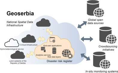
Group 2: dealing with the economic issues, under the supervision of the President of the
   Republic of Serbia.
   The use of geospatial information and services by both working groups assisted in making better
   and more informative decisions, to monitor the fast changing situation and decide what
   measures to be put on place and where most support is needed.
           2. GEOSPATIAL FOUNDATION IN SERBIA INEARLY 2020 – THE START
              OF THE COVID-19 PANDEMIC
   The government of Serbia has been supporting the implementation of the National Spatial Data
   Infrastructure during the last several years, including support to new and innovative approaches
   to national geospatial information management; implementing integrated, evidence-based and
   data-driven decision-making solutions; and maximizing and leveraging national information
   systems tailored to each country’s national situation and circumstances.
   The role of the Republic Geodetic Authority has been considerably changed in the 21st century;
   it is no longer a traditional register of properties and now serves as a national platform for
   sharing geospatial data of the public sector, allowing fast and easy access to the available
   geospatial data in a transparent, reliable and efficient manner, creating new services for the
   government and municipal authorities, private sector and the general public. In responding to
   the new demands, the RGA prepared a Development Strategy until Year 2021 adopted by the
   Government of Serbia in 2017. The strategy defines the priority of actions needed in the legal
   framework, the need to redesign and streamline the business processes in order to improve
   efficiency, accountability, transparency and access to information to all, in parallel to the staff
   capacity building and training for the existing staff and defined the need for hiring people with
   different expertise, that could contribute to increased use of the new and innovative
   technologies and create new services.

            Figure 1: Key pillars for digital transformation of Republic Geodetic Authority
   During the last four years the foundation for digital transformation has been established by the
   Republic Geodetic Authority, led by its Centre for geospatial information management with
   strong support from the Government of Republic of Serbia and various international partners.
   The demand for geospatial data has multiplied during the last several years, which requires a
   completely new way of thinking (digital thinking), as well as the introduction of new and
   innovative technologies and redesign of the business processes.

Geospatial Information in Response to Covid-19 Pandemic – Serbian Experience (11111)
Borko Draskovic, Darko Vucetic (Serbia) and Rumyana Tonchovska (Italy)
FIG e-Working Week 2021
Smart Surveyors for Land and Water Management - Challenges in a New Reality
Virtually in the Netherlands, 21–25 June 2021
2.1. NSDI Legal Framework in Serbia
   In April 2018, the Law on National Spatial Data Infrastructure was adopted by the
   parliament. The National Spatial Data Infrastructure (NSDI) is an integrated geospatial system
   that provides comprehensive identification and access to geoinformation obtained from
   different sources – local, regional, national or global.
   "The integrated Geospatial information in one infrastructure provides many opportunities for
   improving public services, preventing data duplication and inconsistency" (Geosrbija, 2018).
   With the Law on NSDI the Republic Geodetic Authority of the Republic of Serbia became a
   national contact point for the NSDI implementation and is responsible for the establishment,
   maintenance and management of the NSDI national geospatial platform, monitoring and
   reporting on the INSPIRE Directive implementation, maintaining the registers of stakeholders
   and monitoring the spatial data infrastructure development at all levels. Several by-laws have
   been adopted in 2019 and early 2020, regulating the generation of metadata, the rules that
   ensure interoperability and effective way of sharing and use of spatial data and the rules for
   monitoring the implementation of the EU INSPIRE Directive. In 2018, the NSDI became an
   integral part of the most important strategic documents in Serbia and has been recognized by
   all governmental institutions. The most important laws that impact the development of the
   NSDI are: Law on Procedures for Real Estate and Utility Cadaster Registration (2018); Law on
   e-Government (2018); Law on Spatial Planning (2018); Law on Disaster Risk Management and
   Mitigation (2018); Law on Administrative Fees (2017); Law on Free Access to the Information
   for the Public; Law on Personal Data Protection; Law on Data Secrecy; Law on e-Commerce;
   Law on Electronic Documents; Law on Electronic Signature; Law on Copyright and Related
   Rights.
   The most important strategic documents supported by the NSDI are: Economic Reform
   Programme of the Republic of Serbia 2018-2020; Action Plan for Implementation of the
   Strategy of Public Administration Reform of the Republic of Serbia 2018-2020; Action plan
   for DRMR; Action Plan for Implementation of the Government Programme; Programme of the
   eGovernment Development; Programme for position improvement on World Bank Doing
   Business list.
   2.2. Business Processes
   The Serbian Land Administration IT system is a reflection of the current conditions within the
   country. In the past couple of decades, Serbia transitioned through a very difficult period
   marked by economic, political and social crises, which reflected negatively on the land
   administration system itself. Until recently, the land administration system was a generator of
   significant challenges for citizens, government and municipal authorities and the private sector,
   fitting scapegoat for various malversations within the Republic of Serbia. It was very difficult
   to implement infrastructural projects, to develop state administration system, and even to
   guarantee property ownership. In 2017, the RGA realised that the existing business processes
   cannot be digitized due to their analogue nature and the limitations of the legal framework in
   Serbia that has been designed to support the manual processes.

Geospatial Information in Response to Covid-19 Pandemic – Serbian Experience (11111)
Borko Draskovic, Darko Vucetic (Serbia) and Rumyana Tonchovska (Italy)
FIG e-Working Week 2021
Smart Surveyors for Land and Water Management - Challenges in a New Reality
Virtually in the Netherlands, 21–25 June 2021

Figure 2: Business processes in 2017 for a
                                                            Figure 3: Business processes after reform
             property transaction in Serbia
                                                            in Serbia for a property transaction (2022

   It is important that everyone in the system understands that digitalizing does not mean simply
   introducing the IT system and transferring analogue processes into such system; instead, it
   involves digital business processes, digital legal framework and a digital mind-set along with
   the technical solutions, in order to make the digitalizing successful and operational. Otherwise,
   the options are open for various misuses and a system that is not functional and sustainable.
   Establishment of the electronic front desk speeded up transactions and reduced contacts
   between parties and government bodies, while preserving documentation security and legal
   certainty. To achieve this, laws and by-laws were amended, thousands of civil servants were
   trained, while software and equipment was installed and put to use in all RGA offices.
   Document management system and new business processes are introduced. After the
   implementation of new Information system for real estate cadastre business processes will be
   completely simplified and streamlined.
   During the last six years, the time for processing of property transactions in cadastre has been
   reduced from 49 to 4 working days and the estimation is that since July 2018, the redesigned
   business processes saved the RGA clients more than 6 million waiting hours in queue at the
   local RGA offices.
   2.3. Human Recourses
   The importance of capacity building in governmental institutions has been recognized by the
   Government of Serbia as a prerequisite not only for the organizational, but also for
   infrastructural and social development. The Republic Geodetic Authority set an ambitious goal
   to continuously enhance the capacity of its staff in order to improve its operations in a
   sustainable way, which is directly impacting the quality of work and service delivery. In order
   to achieve its vision, the investments in capacity building of its staff have been recognized as a
   prerequisite. The RGA survey showed that some of the weaknesses of the organization are
   coming from the average age and education of its staff. Namely, the survey showed that the
   current average age of RGA employees is 57 and that it is necessary to employ younger
   personnel, as well as to improve the knowledge of the current staff and the newly employed
   staff. At the same time, the World Bank (WB) loan and other government funds have been
   dedicated to the modernization of the RGA, provided a new opportunity to the RGA to achieve
   the set Strategic goals and to invest more in capacity building. Various training has been
   organized and an eLearning platform developed, where every employee can access all video

Geospatial Information in Response to Covid-19 Pandemic – Serbian Experience (11111)
Borko Draskovic, Darko Vucetic (Serbia) and Rumyana Tonchovska (Italy)
FIG e-Working Week 2021
Smart Surveyors for Land and Water Management - Challenges in a New Reality
Virtually in the Netherlands, 21–25 June 2021
materials for all solutions, deployed by the RGA. Having in mind the importance of the Republic Geodetic Authority for the Republic of Serbia and the issues with the employees' structure, the Government of Serbia allowed the RGA to hire additional 657 employees, which is a record in the governmental institutions in Serbia. 2.4. Technology and Innovations Digital transformation of the national economy and public administration are among the key priorities of the Serbian Government. The government of the Republic of Serbia and the Republic Geodetic Authority has been working together to develop a framework for the crowdsourcing technology utilization, combined with the National Spatial Data Infrastructure digital platform. The main objective of the framework is to provide a framework for a more efficient decision making process for the local and national government authorities, towards achieving the Sustainable Development Goals. In 2016, by using very high resolution satellite imagery and a new way of processing, overlapping with cadastre and other data, the Republic Geodetic Authority managed to update the building register with more than 4.5 million additional constructions for the first time in Serbia, which will soon become a part of the national fiscal and economic system. It is estimated that the direct budget revenue from property taxes from the identified 4.5 million unregistered buildings will be over 500 mil Euro/year. Those buildings represent a “dead capital” in Serbian economy. The updated building register was used to make an assessment of the quality and completeness of the Address Register. The estimation has been made that approximately 3 million citizens have no address. By using the geospatial platform Geosrbija and implementing new methods for collecting data, such as crowdsourcing and combining them with the geospatial platform for the National Spatial Data Infrastructure, the RGA has managed to complete the updating of the Address Register in two years. The software for managing and maintaining the Address Register has been redesigned, and over 2 million citizens received full georeferenced address for the first time. These results become possible due to the excellent collaboration between the RGA and the local communities in creating and implementing new standards and using innovative technologies such as crowdsourcing and the geospatial platform. The process of legalization of properties and the completion of the gaps in the Address Register contribute to the economic development of the country, legal certainty and attractive investment environment. Today, thanks to the support from the Government of the Republic of Serbia and the considerable financial and technical support from the World Bank and other development partners, such as UN-FAO, the Republic Geodetic Authority is resolving the long standing issues, inherited from the past, by digitalizing data, streamlining the business processes and introducing innovative solutions and technologies in order to compensate the time lost and to contribute to the economic development of the Republic of Serbia. 2.4.1. GeoSerbia: Serbian National Geospatial Platform The development of the regulatory and strategic framework for the National Spatial Data Infrastructure (NSDI) facilitated full development of the National Geospatial Platform (NGP) Geosrbija. Geosrbija has been officially launched in December 2017. In order to improve the services to other governmental institutions, regional and local municipalities, market and Geospatial Information in Response to Covid-19 Pandemic – Serbian Experience (11111) Borko Draskovic, Darko Vucetic (Serbia) and Rumyana Tonchovska (Italy) FIG e-Working Week 2021 Smart Surveyors for Land and Water Management - Challenges in a New Reality Virtually in the Netherlands, 21–25 June 2021
citizens, a new infrastructure has been implemented with powerful servers and different
   basemap servers, databases for vector data and servers for WMS/WFS services. In addition, a
   new web-based user application has been implemented, which significantly improved the
   national NSDI platform. The new digital platform provides more functionalities, easy to collect,
   connect and create new products that have additional values for the users regardless of their
   role in society or their GIS knowledge. The platform connects data from the government,
   regional and local authorities, academia and researches, private sector, as well as data collected
   by the society and citizens. The NSDI digital platform reduces the need for having additional
   software, enabling the users to get a quick result, which often reduce the cost and the time
   needed to perform the work or providing services to a third party.

                            Figure 4: Geosrbija – the most important services
   The new web application enables improvement and monitoring of the SDG related activities of
   the Government. The new platform provides online public access to discovery and view
   services for spatial datasets and services from the competence of the Republic Geodetic
   Authority and other public authorities. Spatial data and services are available on the GeoSrbija
   from official registers within the jurisdiction of the RGA such as: coordinate reference system,
   geographical grid system, administrative and statistical units, addresses, cadastral parcels,
   orthophoto imagery, elevation, topographic and thematic maps. Based on cooperation with the
   public authorities, it is enabled access to geodata related to demography, land cover, pedology,
   hydrology, climatology, seismology, topographic maps, the road network, protected sites, as
   well as spatial and urban plans for particular areas.

Geospatial Information in Response to Covid-19 Pandemic – Serbian Experience (11111)
Borko Draskovic, Darko Vucetic (Serbia) and Rumyana Tonchovska (Italy)
FIG e-Working Week 2021
Smart Surveyors for Land and Water Management - Challenges in a New Reality
Virtually in the Netherlands, 21–25 June 2021
Figure 5: Geospatial platform - Geosrbija
Geosrbija provides a platform for sharing over 280 public sector datasets and is visited by 4.5
million unique users annually (equivalent to 65% of Serbian population) with over 85 million
requests ensuring that the communications and engagement are always persistent.
2.4.2. Crowdsourcing – CowdSDI APP
The Republic Geodetic Authority has developed a new
mobile application with crowdsourcing functionality –
CrowdSDI, which allows users to take photos of certain
phenomenon of interest and to connect it with digital
platform of National Spatial Data Infrastructure. The mobile
application for crowdsourcing crowdSDI developed by the
Republic Geodetic Authority is very important for the
Figure 6: crowdSDI logo functioning of this system.
The application guarantees that the photographs, coming from the particular location are
recorded by users in the digital platform. The use of a mobile application is enabled through
predefined roles and capabilities of the options used that can be controlled and defined through
the application's administration module. The real advantage of this type of work is in securing
the credibility and quality of the acquired data as well as the elimination of application’s abuse
by creating of controlled technological environment. All reported data is automatically checked
in the database, including the collected coordinates, weather and terrain conditions of the
location where the photo was taken. In addition, topological and other controls are performed
automatically in order to ensure good data quality.
Geospatial Information in Response to Covid-19 Pandemic – Serbian Experience (11111)
Borko Draskovic, Darko Vucetic (Serbia) and Rumyana Tonchovska (Italy)
FIG e-Working Week 2021
Smart Surveyors for Land and Water Management - Challenges in a New Reality
Virtually in the Netherlands, 21–25 June 2021Figure 7: crowdSDI admin panel and reports The CrowdSDI application in combination with Geospatial platform – Geosrbija has been used to update the existing data and to collect new data and information in a very efficient manner. This approach has been used for the first time to update the address register in 2 years. It has been used for demarcation of house numbers and street name. It is important to emphasize that this approach and technology is recognized by the Government of Serbia and it has been used by other Serbian institutions, particularly by Ministry of Culture for collecting and creating register of archaeological sites, Ministry of Environment for creating and maintaining Register of waste dump sites as well as Ministry of Agriculture for supervision in the field. 2.4.3. Geospatial platform for professional users The Geospatial platforms are a central point for all geospatial public data and provide services to citizens, government and private sector. Geospatial platform for professional users is a central point for all services and application for professional users of geospatial data in real- time. Rapid development of new technologies and digitalization of business processes and data resulted in new and efficient request for access to geospatial data via OGC web services and API services. Currently, platform for professional users have 3 million requests every month. It is also important to note that this new approach of data and service dissemination boost development of geospatial business in the Republic of Serbia. 2.4.4. Price register and mass valuation system The RGA's long-term goal is to develop and implement an optimal system of property mass valuation that is in accordance with the international standards and good practices, which makes the real estate market transparent, and ensures the market value of the property of all property rights holders for different purposes of state administration and other needs. The purpose of the mass valuation system is to determine the tax base for real estate taxation on real market grounds and in accordance with the constitutional rights of the citizens. The Republic Geodetic Authority is developing an IT system, organization, competencies and services related to the property mass valuation. Mass valuation system is currently being developed under the World Bank funded Real Estate Management Project, covering several phases: Collecting the Geospatial Information in Response to Covid-19 Pandemic – Serbian Experience (11111) Borko Draskovic, Darko Vucetic (Serbia) and Rumyana Tonchovska (Italy) FIG e-Working Week 2021 Smart Surveyors for Land and Water Management - Challenges in a New Reality Virtually in the Netherlands, 21–25 June 2021
necessary data, data processing from the real estate market, defining the model for property
   valuation, Calculation and registration of property value.

             Figure 9: Property price register information system and mass valuation pilot
   The Price register has already been developed and the system provides segregated data to the
   business and the public users to support the information based decision making process. The
   data collection from the real estate market is done through the Registry. These data are used to
   analyse and describe the real estate market in order to determine market trends over time, value
   zones, and to create models for property mass valuation.
   Since the beginning of 2014, around 700,000 real estate transactions have been registered in
   the Property Price Register, of which approximately 550,000 represent sales. Reports on Status
   of Real estate market in Serbia are generated two times per year representing first and second
   half of each year and finally status of whole previous year. This is crucial information for
   investors, decision makers, citizens and whole Real estate market industry. Thanks to new
   Building register and the updated Address register every transaction is recorded and
   georeferenced (has a geospatial position).
   2.4.5. Cyber Security
   The Republic Geodetic Authority of Serbia manages enormous amount of significant data and
   the systems, operated by the RGA are connected to critical government systems, providing
   various e-services, including at global level. The RGA's digital platforms have been a target of
   different types of attackers with different motivation:
        − Attackers looking for obtaining and/or changing the RGA owned and managed data
        − Attackers looking at the RGA as a pre step to achieve access to critical government
          organizations or global institutions connected to the RGA
        − Attackers performing scanning around Internet for any vulnerability in order to
          blackmail organization and obtain direct material benefits
   “Digital cloning” of the RGA real service are developed, exposing it to Internet for the purpose
   of tracking and measuring any attack attempt. Major findings were:
        − There was ~13000 attack attempts every day (around 9 attacks every minute)

Geospatial Information in Response to Covid-19 Pandemic – Serbian Experience (11111)
Borko Draskovic, Darko Vucetic (Serbia) and Rumyana Tonchovska (Italy)
FIG e-Working Week 2021
Smart Surveyors for Land and Water Management - Challenges in a New Reality
Virtually in the Netherlands, 21–25 June 2021
− Some attackers tried to upload their malware tools for further attacks and establishing
remote connections. Around 15% of all malware tools uploaded were not detected by
our antivirus, showing us that approach of recognising “bad” software using antivirus
cannot guarantee protection.
− Around 2.4% of malware uploaded by attackers was not detected by ANY antivirus
(0/60) (we have been using VirusTotal for checking some file against more than 60
different antivirus engines, and for 2.4% of uploaded malware was not detected by any
antivirus in a first month, then slowly increasing detection rate and achieving over 50%
detection in 3 months period)
− There were targeted attacks – attack attempts coming from IP that has never been seen
before as a bad IP
− There are targeted attacks against the RGA specific applications, showing that attacker
had a knowledge about the RGA's data structure and internal services used
Based on these findings, the RGA developed and implemented a new and comprehensive Cyber
Security system, based on the ASPEN solution.
The ASPEN solution provides,
besides “digital cloning” and digital
traps a possibility for advance real
time incident detection and
correlation being capable to detect
an attack or abnormal behaviour in
5ms and react accordingly. An
incident forensic has been developed
as well as an auto remediation,
which means that any attacker can be
blocked in real time if malicious
Figure 10: Real time map showing ongoing attacks behaviour is detected.
against the RGA
Geospatial Information in Response to Covid-19 Pandemic – Serbian Experience (11111)
Borko Draskovic, Darko Vucetic (Serbia) and Rumyana Tonchovska (Italy)
FIG e-Working Week 2021
Smart Surveyors for Land and Water Management - Challenges in a New Reality
Virtually in the Netherlands, 21–25 June 20213. USING GEOSPATIAL INFORMATION IN SERBIA DURING THE
COVID-19 PANDEMIC
3.1. Technical infrastructure in support of decision making during the COVID-19
Figure 11: Structural schema of decision making and information based on geospatial data
during the COVID-19
Thanks to the work completed in the past three years, the Republic of Serbia and the Republic
Geodetic Authority were able to create new services and to provide data, when the covid-19
pandemic suddenly started. Geospatial platform and its interoperability with the most critical
systems and registers and the newly established building register, the updated address register,
the sales price register played a crucial role in responding to the demands of various authorities
and helped monitoring the implementation of various government decisions, as well as for
planning the social, health and economic interventions. The integration of the geospatial
platform was done with the basic statistical data, whole transport network, including railways,
roads, water and others, as well as with the complete networks of health and the education
systems. Using the available tools and data and the geospatial platforms, the Republic Geodetic
Authority became a central source of information for the decision making process in Serbia
during the pandemic, starting from planning the responses and going to estimation of the impact
and planning the recovery and identifying areas for improvements after the pandemic.
3.2. Information tool of the Geospatial platform for covid-19 in Serbia
Serbian institutions, responsible for managing the covid-19 response received up to date
information on georeferenced registered cases which acted as a binder of critical governmental
data available from the relevant sources. The graphic presentation allowed the definition of high
risk and medium risk zones within the settlements with full details for the authorised
governmental and municipal bodies, while public was provided with more general information
respectful of the privacy and confidentiality rights of the citizens, yet sufficient to promote safe
conduct and prevention. Thus, the system was not only used for a detection and prevention but
also for a public response management.
Geospatial Information in Response to Covid-19 Pandemic – Serbian Experience (11111)
Borko Draskovic, Darko Vucetic (Serbia) and Rumyana Tonchovska (Italy)
FIG e-Working Week 2021
Smart Surveyors for Land and Water Management - Challenges in a New Reality
Virtually in the Netherlands, 21–25 June 2021Figure 12: Information tool of the Geospatial platform for the covid-19 in Serbia
3.3. Additional functionalities and tools
Additional functionalities and tools of the Geospatial platform have been developed to
respond to the new demand. One of the key tools is spatial-temporal analytics and visualisation
tool. This tool allows for monitoring the COVID 19 spread, monitoring if the positive tested
for covid-19 people and people in isolation are respecting the restrictions. Another important
improvement was the integration of the “Street view”, which allows for better preparation for
the field work and reaction, if needed. Additional tools were developed to ensure real-time
integration with external systems for Register of citizens, Heath information system and others.
3.4. Data
Idea is that data about location for every person who are in isolation for any reason or was tested
positive on covid-19 to be integrated in the geospatial platform together with basic information,
collected by the responsible institutions. Based on those data, it would be possible to create a
heat maps1 or risk zones. For that reason, special algorithm has been developed with different
level of confidence and weight for different data, based on their status. The integration with the
statistical data allowed generation of complete reports needed for health, social and economic
decision making. The Statistical office in cooperation with the Republic Geodetic Authority
provided detailed information using the Geospatial platform and location based data about:
− Citizens and population - number, gender, age, number of children
− Economy = number of employees, salaries, number of unemployed, number of business
entities, business structure, state budget, local budget etc.
− Agriculture - number of agriculture land and registered entities, number of people
working in Agriculture sector and their structure, number of domestic animals and
structure etc.
− Education – structure of education among the citizens, number of pre-elementary,
elementary, high and faculties etc.
− Culture – information of the number and structure of cultural sites and infrastructure
1
Heat map (or heatmap) is a data visualization technique that shows magnitude of a phenomenon as color in two
dimensions.
Geospatial Information in Response to Covid-19 Pandemic – Serbian Experience (11111)
Borko Draskovic, Darko Vucetic (Serbia) and Rumyana Tonchovska (Italy)
FIG e-Working Week 2021
Smart Surveyors for Land and Water Management - Challenges in a New Reality
Virtually in the Netherlands, 21–25 June 2021− Health – number of doctors, structure of doctors by the expertise, number and structure
of vulnerable people (pregnant, diabetes, etc.)
− Social protection – information of social cases and protection infrastructure
− Traffic and communication infrastructure
The Republic Geodetic Authority together with other institutions managed to map in few days
all senior and nursing homes and social welfare infrastructure, collected data about capacities
and current status, including the number of workers and level of occupancy. Those data were
included in the Geospatial platform and combined with other data and the risk zones. Those
data have been used afterwards for planning the protection and measures for response.
Complete health network and infrastructure have been mapped, located and included in the
Geospatial platform. Special attention has been paid to the COVID 19 dedicated clinics and
COVID 19 hospitals with additional information. COVID 19 clinics contained information
about location, working hours, contact information and basic information about reaction of the
citizens if they are suspect of COVID 19 virus which was done in cooperation with Office for
IT and eGovernment. COVID 19 hospitals contained information about location, capacities,
number of equipment and other relevant information. The Health infrastructure contained
information about other types of hospitals, Special hospitals, Community health centers, Health
institutes, Clinical centers, Pharmacies etc.
The data about the condominium register and the information about the responsible person of
the condominium, including the contact details, were very useful for independent and additional
control over the respecting the government and municipal measures enforced by the responsible
institutions.
3.5. Use cases: New geospatial services during Covid-19 pandemic
3.5.1. Health
All health institutions and health support places were mapped for the purpose of response
planning, while general public had a view service on the Geoserbia geospatial platform.
Furthermore, the system is being used in support of prophylaxis measures through full address
registration of the suspect individuals, which were subject to the self-confinement, which in
turn enabled the Government of Serbia to plan and execute control of the imposed quarantine
measures.
Geospatial Information in Response to Covid-19 Pandemic – Serbian Experience (11111)
Borko Draskovic, Darko Vucetic (Serbia) and Rumyana Tonchovska (Italy)
FIG e-Working Week 2021
Smart Surveyors for Land and Water Management - Challenges in a New Reality
Virtually in the Netherlands, 21–25 June 2021Figure 13: Idea for Covid-19 application with high risk zones and locations of people in
quarantine
Figure 14: Idea for application of location of people in isolation and, link with address register
and street view of residential property
Usage of crowdSDI (crowdsourcing platform) was investigated for monitoring the movement
of people in isolation, but later it has been concluded that it is not fully in line with the legal
regulations for personal data protection.
3.5.2. Economy
The regular services have been redesigned to enable citizens and economy to mitigate damage
and conduct safer day to day activities during the peak of the COVID 19 crisis. Electronic
communication related to cadastral transactions were fully digitalised, adjusted and
implemented with prompt legislative amendments. The physical contact of the RGA's staff with
clients has been reduced to minimum while the time for completing transactions slightly
improved. In addition, the data required for economic stability, for example real estate property
market trends, became publicly available on a weekly basis in order to boost confidence and
inform economic groups, so they can react accordingly. Thus the real estate market in Serbia
Geospatial Information in Response to Covid-19 Pandemic – Serbian Experience (11111)
Borko Draskovic, Darko Vucetic (Serbia) and Rumyana Tonchovska (Italy)
FIG e-Working Week 2021
Smart Surveyors for Land and Water Management - Challenges in a New Reality
Virtually in the Netherlands, 21–25 June 2021suffered only marginally with good prospect to increase in volume compared to 2019 which
was the best year in the history of the real estate market in Serbia.
Figure 15: Real estate market status during the COVID-19 - 2019 vs. 2020
4. LOOKING FORWARD
4.1. What could be done better?
4.1.1. Legal framework
The outbreak of the COVID19 pandemic established an immediate need to prepare amendments
to the Law on Health Documentation and Records in the Field of Healthcare, which were not
fully aligned with the Sendai Framework for Disaster Risk Reduction. Article 22 of the Law on
Disaster Risk Reduction and Emergency Management (“Official Gazette of the Republic of
Serbia”, No. 87/2018; hereinafter: the Law) requires the establishment of the DRR containing
the relevant data for risk management. The law prescribes the content, the manner of
establishment and the maintenance of the Disaster risk register, and tasks the SEM with the
coordination of data collection. It also obliges all the relevant ministries and stakeholders to
provide their data and to keep them up to date.
4.1.2. Data sharing
Despite this large number of portals and systems at the national and local levels, data sharing
remains a considerable issue, and suffers from a lack of formal agreements among various
administrations, national agencies and private stakeholders at both national and local levels.
The recommendation has been made to establish formal and consolidated agreements among
the different national and local administrations and the SEM, which would coordinate the
process.
4.1.3. Data collection and data quality
Serbia has been making considerable efforts to collect and record the disaster losses data in the
Desinventar database, which is largely compliant with UNDRR requirements. This activity is
an important starting point for meeting the EU requirements in recording loss data. The SEM
consolidates data from several stakeholders and then standardises them in collaboration with
the Statistical Office, which also has the task of enter them into the Desinventar database. A
Geospatial Information in Response to Covid-19 Pandemic – Serbian Experience (11111)
Borko Draskovic, Darko Vucetic (Serbia) and Rumyana Tonchovska (Italy)
FIG e-Working Week 2021
Smart Surveyors for Land and Water Management - Challenges in a New Reality
Virtually in the Netherlands, 21–25 June 2021new project is underway involving the Statistical Office, the SEM and local government units
and ministries to collect historical data from 1980 onwards for inclusion in the Desinventar
database.
Article 22 of the Law requires the establishment of the DRR containing the relevant data for
risk management. The Law and Rulebook on content, setup and maintenance of the disaster
risk register (“Official Gazette of the Republic of Serbia”, No. 78/2019) prescribes the content,
the manner of establishment and maintenance of the Risk Register, as well as tasks of the SEM
with the coordination of data collection. It also obliges all the relevant ministries and
stakeholders to provide their data and to keep them up to date.
4.1.4. Location-based census
The last census in Serbia was not location based and this created some issues during the covid-
19 pandemic to integrate statistical data with other geospatial data. A decision has been made
that the next national census, planned for 2021 to be location based.
4.1.5. Digital georeferenced risk prevention plans
Most of the risk prevention plans are currently provided in document form and are available via
the DRIS platform. It is very important in the future to address the need of their digitalisation
and geotagging in order to integrate them, while building them on the information provided by
the DRR. With the exception of Dewetra, which is not yet fully functional, there is no additional
information support for this purpose.
4.1.6. Technical platforms
− Disaster Risks Register (subsystem of GeoSerbia)
The Republic Geodetic Authority (RGA) in coordination with the Ministry of Interior will play
a key role in establishing and maintaining the technical infrastructure for the access and use of
data from the DRR, following the Regulations governing the area of the national geospatial data
infrastructure. The digital geospatial platform is already visible on the RGA and National
Spatial Data Infrastructure websites and contains over 280 various datasets from national
stakeholders (as of June 2020). It will be an important platform for assessing vulnerability by
providing data and creating various maps. The platform, together with the legal and technical
framework of the National Spatial Data Infrastructure, will serve to link with other data needed,
and will serve to form the DRR. The DRR is a subsystem of the National Spatial Data
Infrastructure system. The conceptual model of the DRR deals with various aspects of the future
distribution system. The definitions of the individual components of the proposed DRR system
are given, together with the description of their purposes and functionalities at a conceptual
level. For this purpose, the following aspects are considered: Definition of the purpose of the
DRR; Definition of its key functionalities; Logical system design that determines the key
system components and defines relationships and connections between them.
Geospatial Information in Response to Covid-19 Pandemic – Serbian Experience (11111)
Borko Draskovic, Darko Vucetic (Serbia) and Rumyana Tonchovska (Italy)
FIG e-Working Week 2021
Smart Surveyors for Land and Water Management - Challenges in a New Reality
Virtually in the Netherlands, 21–25 June 2021Figure 16: The context of the Disaster Risk Register in Serbia From a conceptual perspective, the Disaster Risk Register is considered as a subsystem of GeoSerbia that is part of the National Spatial Data Infrastructure of the Republic of Serbia. As such, it is loosely integrated with other subsystems from which it gathers thematically relevant data systematically, provides analytics capacities for generation of dedicated data products and distributes them to the relevant data users. Therefore, it addresses the challenges, related to the sharing of data among various administrations, national agencies and private stakeholders at both national and local levels. It could benefit from the following extension of its functionalities (ref. Fig. 4): Data harvesting from third party data sources, in particular to global open data sources; Integration of sensory platforms in support of Disaster Risk Management; Support for crowdsourcing platforms and initiatives for rapid data collections in time of actual crisis and beyond; Processing of third-party, sensory, and crowdsourced data for the creation of new data products with dedicated analytics services; Distribution of data products to relevant authorities; Support development of dedicated applications in the Disaster Risk Management by enabling evolutionary development based on an agile project management philosophy. The DRR is a one-stop-shop system for all relevant data and services that consist of four conceptual layers, as shown in Fig. 3. While the data sources, services and applications follow the functional system requirements, the DRR users can be divided roughly into four groups: 1) Professionals (such as firefighters and civil protection) who access the data through dedicated (primarily mobile and web) application, tailored for their needs. The latter often requires fast response times of dedicated services with high levels of priority and security; 2) Institutions (such as SEM, NEMH, and PIMO) who access the data and the analytics capacities of the Register through (web and possibly standalone) applications that allow for system management and administration, data administration, and integration of new services and data sources, as well as extraction of reports and statistics needed for their business processes; 3) General public, who primarily access web or mobile applications to obtain relevant information about the critical events or to provide the data when needed, and, finally; 4) International data exchange with other countries that can access dedicated APIs for this purpose in order to support efficient cross-border and international collaboration in those cases of major critical events and actions that require multinational collaboration. Geospatial Information in Response to Covid-19 Pandemic – Serbian Experience (11111) Borko Draskovic, Darko Vucetic (Serbia) and Rumyana Tonchovska (Italy) FIG e-Working Week 2021 Smart Surveyors for Land and Water Management - Challenges in a New Reality Virtually in the Netherlands, 21–25 June 2021
Figure 17: The concept of the Disaster Risk Register in Serbia
   The national DRR will enhance national resilience of a society to disasters. The register will be
   built on the foundation of a Geoserbia as geo platform integrating all relevant digital data that
   has a location dimension to it. The process of planning national and individual responses to any
   emergency event will become possible in real time.
   The Disaster Risk Register will be interoperable with price register, utility cadastre, and other
   important data sources, so it could support the development of dedicated applications for this
   purpose; however, only on a generic level. Such common activities can, for example, include
   applications for monitoring pandemic cases (e.g. COVID-19, etc.) using geospatial, health, and
   statistical sources and services.
       − CrowdSDI mobile for DRR

                                               CrowdSDI mobile is a new application for emergency
                                               response within the Risk register information system.

                                               It will use the existing CrowdSDI platform for
                                               emergency cases as part of the new Disaster Risk
                                               Register for data collection from the areas of
                                               emergency and for data submission, quality check and
                                               processing.

         Figure 8: CrowdSDI mobile
       − RGA's systems

Geospatial Information in Response to Covid-19 Pandemic – Serbian Experience (11111)
Borko Draskovic, Darko Vucetic (Serbia) and Rumyana Tonchovska (Italy)
FIG e-Working Week 2021
Smart Surveyors for Land and Water Management - Challenges in a New Reality
Virtually in the Netherlands, 21–25 June 2021
The RGA Immovable Property Registration and Cadastre IT System (ISREC), which is in its
third phase of implementation, creates an enabling digital environment, allowing all business
activities, irrespective of location, to be performed digitally with minimal or no need for
personal contacts/visits to the local offices to submit or collect documentation. Therefore, it is
expected to improve the resilience to any future health related disaster event by enabling
nationwide processing of transactions and central storing of data in different backup locations.
The economic environment in Serbia will benefit from further development of the Mass
Property Valuation System and the development of an Investment Location Mapping System
(SIDA supported project). Both systems will support the government and the industry to use
relevant, accurate and up to date data for decision making. Final effect of the activities will
favour better socio economic environment and national resilience to the poverty spread.
− Capacity building
The outbreaks of the pandemic diseases (namely COVID 19), floods, and wildfire risks have
been prioritised, as these represent the highest risks for Serbia. Guidelines for management of
forest fire risks has been stipulated in the Law on Forestry, mandating that all forests must have
their own protection plan with detailed instructions on the best response. In addition, other risks
prevention plans have to be prepared by the local authorities in accordance with their priorities.
Experts’ operational teams have been established focusing on landslides and erosion, floods
and large forest fires to advance the knowledge in the areas of particular risks in specific areas
with the purpose of prevention. The staff of these teams comprises of representatives from
ministries, scientific institutions, and other relevant organisations.
Bibliographical notes:
Borko Drashkovic,MsC, is director of Republic Geodetic Authority of Serbia occupies this
position since July 2015. As a result of the reforms he has undertaken, he was awarded title
“Reformer of the Year” in January 2019 by National Alliance for Local Economic Development
– NALED. In addition to this prestigious prize, he also holds numerus international
appreciations like the one from The World Bank for supporting the study “Women, Business
and Law”. He is also a member of UN GGIM and creator of the idea for crowdSDI which was
presented on many conferences organized by United Nations and The World Bank. He
succeeded to improve transparency in real estate cadaster and work of Republic Geodetic
Authority. As a result, appreciation form American professional services and investment
management company specializing in real estate “Jones Lang LaSalle” has arrived for making
the greatest move forward in this field. Digital geospatial platform for Serbian National Spatial
Data Infrastructure is operating for over a year and within that time it gathered over 240 data
sets from many institutions in Serbia.
Borko Drašković is also active in social life as a board member of Sport Association “Partizan”
and as a president of the assembly of Moto Association of Serbia.
Darko Vucetic, MsC, is a Head of Center for Geospatial information management at Republic
geodetic authority of Serbia. Darko’s main activity is to seek and provide the most optimal
Geospatial Information in Response to Covid-19 Pandemic – Serbian Experience (11111)
Borko Draskovic, Darko Vucetic (Serbia) and Rumyana Tonchovska (Italy)
FIG e-Working Week 2021
Smart Surveyors for Land and Water Management - Challenges in a New Reality
Virtually in the Netherlands, 21–25 June 2021solutions based on geospatial data management to all public sector institutions within the NSDI and to ensure strategic approach for geospatial data use at the national level. Center using innovative approach and technologies, develop fit-for-purpose solutions, methodologies and business processes, provide capacity building and awareness rising for usage of geospatial data and much more. He was also Management board member of Eurogeographics, organisation representing Europe’s National Mapping, Cadastral and Land Registration Authorities. Rumyana Tonchovska, M.SC, is a Senior Land Administration-Information Technology Officer of the Food and Agriculture Organization of the UN (FAO), based in Rome. Rumyana holds a Master’s Degree in Information Technology with practical experience in 26 countries in Eastern Europe, Asia and Africa in design, development and implementation of largescale complex information systems for land tenure, indirect finance and building Spatial Data Infrastructure. Before joining the FAO in 2009, Rumyana worked as UNISYS Senior Project Manager, IT Director at the Bulgarian Ministry of Justice, Head of the EU Funded Program Department at the Bulgarian Customs Agency (Ministry of Finance) and assistant professor at Technological University in Sofia. Rumyana is leading various innovations to test new approaches and technologies, aiming at improving tenure governance, making best use of the available geospatial data and technologies, and building local capacity for evidence based policy making. She has been actively involved in the development of the Integrated Geospatial Information Framework and its implementation at country level. Geospatial Information in Response to Covid-19 Pandemic – Serbian Experience (11111) Borko Draskovic, Darko Vucetic (Serbia) and Rumyana Tonchovska (Italy) FIG e-Working Week 2021 Smart Surveyors for Land and Water Management - Challenges in a New Reality Virtually in the Netherlands, 21–25 June 2021
You can also read