Fieldwork in Ground Zero, Mallorca. A Methodological Fieldwork Proposal for a Geographical Analysis of Tourist Areas
←
→
Page content transcription
If your browser does not render page correctly, please read the page content below
Nº 75, january-june of 2021, pp. 43-59.                                                                                     Investigaciones Geográficas
ISSN: 0213 - 4691. eISSN: 1989 - 9890.                                                                             Interuniversity Institute of Geography
DOI: 10.14198/INGEO2020.BB                                                                                                          University of Alicante

To cite this article: Blázquez-Salom, M., & Blanco-Romero, A. (2021). Fieldwork in Ground Zero, Mallorca. A Methodological Fieldwork
Proposal for a Geographical Analysis of Tourist Areas. Investigaciones Geográficas, (75), 43-59. https://doi.org/10.14198/INGEO2020.BB

             Fieldwork in Ground Zero, Mallorca.
            A Methodological Fieldwork Proposal
         for a Geographical Analysis of Tourist Areas
                Trabajo de campo en la Zona Cero, Mallorca.
      Propuesta metodológica de análisis geográfico de núcleos turísticos

                                                 Macià Blázquez-Salom1*
                                                Asunción Blanco-Romero2

Abstract
    For scientific headway to be made in the field of social science today, direct contact with analysed
phenomena is all-important. The research hypothesis we put forward is that, just like practical laboratory
work, fieldwork is an indispensable tool in tourism geography in guaranteeing rigorous scientific studies.
The aim of this paper is: 1) to help demonstrate the usefulness of fieldwork in tourism geography in
enriching the taught theory and concepts; 2) to design useful methodological tools for planning student-
driven, enquiry-based learning processes; 3) to use Mallorca as a case study in a direct analysis of the
complex spatial consequences of the Anthropocene on the tourist industry. Our teaching and research
experience in tourism geography, particularly in relation to global change during the Anthropocene, are
fundamental in achieving these objectives. We conclude that fieldwork helps students to develop important
skills and competences, facilitating meaningful learning. Through the students’ active participation, the
teacher is no longer a transmitter of theoretical knowledge, but a facilitator in the learning process.
    Keywords: tourism geography; Mallorca; fieldwork; Anthropocene; meaningful learning; experimen-
tation; skills and competences.

Resumen
    La importancia para el avance científico del contacto directo con los fenómenos analizados es actual-
mente incuestionable en las ciencias sociales. De manera similar a la investigación de laboratorio, nuestra
hipótesis defiende que el trabajo de campo en geografía del turismo es una herramienta insoslayable para
llevar a cabo un estudio científico riguroso. En este contexto, el presente estudio propone: 1) contribuir
a demostrar la utilidad del trabajo de campo para enriquecer el proceso de aprendizaje de geografía del
turismo, mediante la definición de su corpus conceptual y teórico; 2) diseñar herramientas metodológi-
cas útiles para planificar procesos de aprendizaje basados en la autonomía de los estudiantes y su enfoque
basado en la indagación; 3) usar el caso de Mallorca para ejemplificar su aplicabilidad al análisis de las
complejas consecuencias territoriales del Antropoceno en la industria turística. Para alcanzar estos objeti-
vos, se utiliza la experiencia directa de enseñanza e investigación en geografía del turismo y, en particular,
sus vínculos con el Antropoceno. Concluimos que el trabajo de campo ayuda a desarrollar habilidades
y competencias importantes de los estudiantes, facilitando un aprendizaje significativo. La inscripción
participativa del estudiante hace que el/la docente ya no sea un mero transmisor de conocimiento teórico,
sino el facilitador en el proceso de aprendizaje.
    Palabras clave: geografía del turismo; Mallorca; trabajo de campo; Antropoceno; aprendizaje signifi-
cativo; experimentalidad; habilidades y competencias.

1 Geography Department. Universitat de les Illes Balears (Spain). mblazquez@uib.cat. * Corresponding author
2 Geography Department. Universitat Autònoma de Barcelona (Spain). asuncion.blanco@uab.cat

Received: 06/08/2020.                             Accepted: 10/14/2020.                                          Published: 06/15/2021 (in press: 11/10/2020).
                                    This work is published under a license Creative Commons Attribution 4.0 International License.
                                                   © Macià Blázquez-Salom, Asunción Blanco-Romero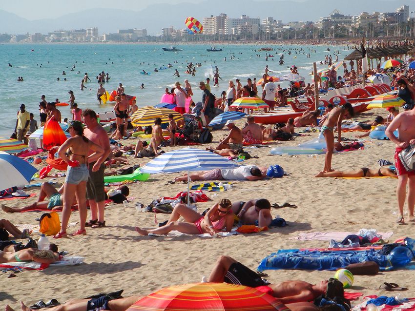
Blázquez-Salom, M. and Blanco-Romero, A.

1. Introduction
     Direct contact with analysed phenomena is fundamentally important in science advancement. Field-
work contributes to the acquisition of skills, tools and conducive attitudes to global change, just as prac-
tical laboratory work contributes to countless research processes. In an age of social isolation fostered by
our dependence on ICTs, fieldwork is an innovative educational tool.
     Planning teaching activities is always a creative challenge for teaching staff. In the current scenario
of the COVID-19 pandemic, we long to take advantage of the benefits of fieldwork. With the resulting
economic crisis, fieldwork will be needed in order to study spatial restructuring processes. At the same
time, the health crisis will lead to a change in the tourism model. Based on these premises, one important
challenge in social science education is to analyse the links between global change (including pandemics)
and tourism. When tourism geography is taught in relation to contexts of global change, fieldwork can be
an important means of intercultural enrichment (just as tourism can be) through interaction with others
who are culturally different from us and by boosting a raised socio-ecological awareness, emotional
intelligence, capacity for critical thinking and global citizenship.
    The current crisis-driven world scenario points to situations of social polarization, particularly at mass
tourist destinations. The COVID-19 pandemic has accentuated existing situations of polarized uneven
geographical development, including ones relating to the tourist industry. Crises call for restructuring
processes, and tourist destinations are not exempt from this (Murray, Yrigoy & Blázquez-Salom, 2017).
Mallorca is a Ground Zero in terms of its poor economic prospects, given the virtual halt in tourist flows
caused by the pandemic (Bohórquez, 28/04/2020). Due to Mallorca’s hyper-specialization in tourism, the
Balearic government estimates that the archipelago will experience a 31% drop in the GDP and the destruc-
tion of 147,000 jobs (Comunidad Autónoma de las Islas Baleares, [CAIB], 2020). Within the framework of
global change during the Anthropocene, research into crisis processes caused by the COVID-19 pandemic
raises numerous geographical issues that can be explored through fieldwork, in particular, the spatiality of
social, economic and environmental change. At a more in-depth level, the issues to investigate include how
economic crises have been used to restructure tourism; how tourists at destinations are segregated by social
class and origin; what role domestic tourism can play in the recovery; how financial stimuli can mitigate
climate change; and whether this is an opportunity to curb urban tourism growth, reshaping the built en-
vironment so that it is better adapted to scenarios of global change (Gössling, Scott, & Hall, 2020) in terms
of factors like transport infrastructure, accommodation capacities or shoreline and beach management.

1.1. Aims and scope
    Within the above framework, this research paper aspires to design an approach to fieldwork for tourism
geography students that focuses specifically on popular tourist resorts and their need for restructuring,
given uncertain future scenarios of global change brought about during the Anthropocene. To study this
issue, possible indicators relating to the following processes can be used: tourist and migratory mobility;
increasing consumption of petroleum products for tourist transport; global warming; rising sea levels
and their impact on beach management; changes in land use in built environments, such as urban sprawl
or proposed extensions to airports; and the role of urban and regional planning. Further aims are: 1) to
demonstrate the usefulness of fieldwork in enriching how the theoretical and conceptual rudiments of
tourism geography are taught; 2) to design a set of methodological tools able to enrich the epistemology
of fieldwork when used for teaching purposes; 3) to use a case study for the direct observation and
analysis of the spatial consequences of the aforementioned processes. In this way, we intend to fill an
existing gap by creating methodological guidelines for this kind of fieldwork.
    With this as our premise, we set out to draw up detailed guidelines on how to use fieldwork in teaching
and research activities, hence allowing students to gain a first-hand insight into certain phenomena and
to compare geographic knowledge with realities. As a practical case study, we include an analysis of
Mallorca: a unique testing ground offering multiple research opportunities. Our suggested topics for
analysing the links between tourism and the Anthropocene are: 1) the interrelations among air traffic
tourist flows, the consequences in terms of global warming and rising sea levels, and beach and seashore
management; 2) land use changes in built environments, 3) planning the growth of tourist areas at an
urban and regional level.
    This paper is structured as follows. Chapter 2 reviews the state of the art, introducing some key con-
cepts related to learning objectives (experimentation through fieldwork, and the purposes of geography

44                                                                      Investigaciones Geográficas, nº 75, pp. 43-59.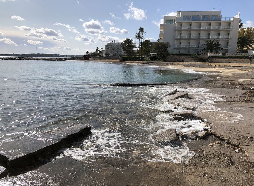
Fieldwork in Ground Zero, Mallorca. A Methodological Fieldwork Proposal for a Geographical Analysis of Tourist Areas

and tourism geography). This is followed, in chapter 3, by a brief outline of the method used for our study.
Chapter 4 describes the most common fieldwork tools and methods and our own methodological proposal,
based on hypothesis development, data collection, observation, and mapping. Chapter 5 offers a proposed
hypothetical-deductive guide, using Majorca as a case study, while chapter 6 outlines the strengths and
weaknesses in relation to current knowledge on the subject, rounded off with some concluding remarks.

1.2. State of the art
    In geography teaching, direct contact with reality, through fieldwork, can be used as a means of
boosting skills and attitudes and acquiring useful tools. Fieldwork is based on the collection of primary
data and it can take a real-world problem-solving approach, for instance, through Participatory Action
Research methods (Breitbart, 2010). The COVID-19 pandemic has demonstrated the fragility of the mass
tourism model and the need to prevent other global change catastrophes related to the Anthropocene
(Crutzen, 2002), such as rising sea levels or growing inequality due to the uneven distribution of wealth.
What the Anthropocene signifies is that the human impact on the world environment is now so large,
within the Holocene’s natural variability as a baseline for interpreting the world changes currently in pro-
gress, that the Earth has now entered a new geological epoch. As a concept, the Anthropocene automati-
cally implies a connection with the physical world, linking humans–in our case students–to planet Earth
and making humankind responsible for tackling these changes (Prince, 2020). Within this context and
that of the tourist industry, one of the current era’s most important challenges is for a specific response to
be found to demands for appropriate, fair degrowth at most hitherto over-saturated coastal mass tourist
destinations by boosting their socio-spatial resilience (Blanco-Romero & Blázquez-Salom, 2021).
    Geographical fieldwork is a connective practice (Haigh, 2017) that allows for the creation of an
empathic, emotional relationship between the learner and an “other” (Monk, 2000). In an era of increasing
social isolation, ICTs lead to spatio-temporal discontinuity –and what have been termed “deterritorialized
spaces”–, where fragmented versions of reality are consumed (Antolín, 2019). Teaching through fieldwork
can help to alleviate this disconnection from reality. In France and Haigh words: “Fieldwork is a signature
pedagogy of geography. It is the place where geographers learn to connect classroom theory with the
real world, where they learn to practice their geo-capabilities and key geographical skills as well as
enhancing their general graduate capabilities, such as problem solving, critical thinking, team-working
and emotional intelligence.” (2018, p. 508).
    This way, the challenge of fostering an interest in education by students can be overcome through
real situations (Santiago, 1998). As a teaching strategy, fieldwork gives students the opportunity to ex-
perience natural phenomena through direct contact with them for the purposes of their scientific inter-
pretation and analysis (Sánchez & Godoy, 2002). This cognitive process can be described as meaningful
learning; that is, feeling that all the components of a concept, idea, theory, formula, or argument come
together. This process of meaningful learning occurs when students build up the knowledge and cogni-
tive processes that are required to tackle problem-solving tasks (Torrisi-Steele, 2009).
    Many other disciplines, like ecology, geology or anthropology, use fieldwork as a key strategy. For
ethnographers, for instance, fieldwork does not have a structure that can be coded and taught. In other
words, it is not a mysterious process: “There is nothing more to fieldwork than meets the naked eye”
(Fletcher, 2007, p. 19). Individual reflection is all that is needed.
    Fieldwork encourages experimentation, contributing to a better understanding and critical analysis
of knowledge, much like the practical work conducted in laboratories, where, for instance, a particular
phenomenon is reproduced and its response is determined when certain variables or independent controllable
or explanatory factors are modified. In the field of social science, criteria are analysed and validated–for
example, by studying documents or through reflection, discussion or the defence of roles–, attempting
to reproduce realities in the classroom. Experimentation through fieldwork consists of an analysis of the
variables that determine a non-reproducible social phenomenon. This implies studying the spatial realities
of tourism and speculating on the explanations through a hypothetical-deductive exploratory analysis.
Direct information gathered in the field provides first-hand data; that is, quantitative, qualitative or mixed
samples that are hard to obtain through other remote analytical methods, such as aerial photography or
satellite imagery. Last but not least, fieldwork contributes to an understanding of geographical phenomena
through the development of techniques like observation, conjecture and explanation in the field. From a
student viewpoint, fieldwork activities can be classified according to two basic criteria: observation (not

Investigaciones Geográficas, nº 75, pp. 43-59.                                                                         45
Blázquez-Salom, M. and Blanco-Romero, A.

interfering) versus participation (interacting, for instance making enquiries so as to gather answers to
research questions), on the one hand, and dependency (listening to explanations, as in staff-led activities)
versus autonomy (when students are in charge of the process) (Kent, Gilbertson & Hunt, 1997). Within
the scope of these possible options, participative observation and a certain degree of autonomy are an
appropriate mix for problem-based learning (PBL) as a means of fostering self-experience and independent,
critical learning processes through student-centred pedagogical tools (Pawson, et al., 2006; Thomas, 2009).
France and Haigh (2018) offer a more detailed classification of types of fieldwork, summarised in Table 1.

                                               Table 1. Types of fieldwork

  1   Teacher-centred, using fieldwork to illustrate the teacher’s explanations, given during “Cook’s Tour” coach stops.
  2   Fieldwork as a laboratory for surveying, mapping or sampling.
  3   Project-oriented, team-working and inquiry-based approaches which connect theory and practice.
      Curriculum-centred to develop discipline-specific attributes, such as emotional intelligence, critical thinking,
  4
      problem solving and global citizenship.
      Technologically-enhanced data collection and interactivity, exploiting the development of GIS, GPS, Google Earth,
  5
      Geotagging, Social Networking, etc.
  6   Research apprenticeship as hands-on experience of the processes of knowledge creation.
      Reflective international fieldwork, as a means of contributing to the intercultural enrichment of the curriculum,
  7
      interacting with those who are not culturally akin to us (McMorran, 2015).
                                       Source: France and Haigh (2018). Own design

    In the field of geography, an initial body of literature was built up on fieldwork methods and its con-
tributions, in particular by Piotr A. Kropotkin (1885), Elisée Reclus (1901) and Carl O. Sauer (1956). In
a more radical approach to geography, William Bunge promoted “urban geographic expeditions” as an
educational project involving the inhabitants of disadvantaged neighbourhoods in order to foster more
democratic, participative teaching methods and activist forms of research (Benach, 2017). In geology, this
technique was enriched by proposals like those of Pedrinaci, Sequeiros and García de la Torre (1994).
Both disciplines have put forward solid arguments in favour of fieldwork methods, including Spanish de-
fences by Manuel de Terán or Lluís Solé Sabarís, rooted in the pedagogical concept of geographical hikes,
developed in Spain by the Institución Libre de Enseñanza (The Institute for Academic Freedom). Field-
work was included in its learning activities, but not as part of the official curriculum. This consideration
has only recently changed. A review of Spanish literature on the current use of fieldwork highlights four
approaches: 1) as teaching resource; 2) in spatial interpretation; 3) for the presentation of case studies;
and 4) incorporating ICTs (Morote, 2019). In tourism studies, fieldwork has mainly been used for case
studies to explore and uphold the value of natural and cultural heritage (Mínguez, 2010) and, less often,
to diagnose and offer solutions to the negative aspects of tourist development, such as the gentrification
of urban public spaces due to tourism commodification (Martínez-Hernández and Yubero, 2020).
    Through geography, spatial phenomena can be explained by examining interrelating social, economic
and environmental variables, in addition to analysing the said variables’ spatial distribution. Fieldwork
thus combines direct data-gathering with the development of more comprehensive exploratory and ex-
planatory geographical analysis techniques.
    In recent times, tourism–an activity closely linked to new socio-economic dynamics–has brought about
one of the biggest spatial changes in Spain (Murray, 2015), expanding to the point of overtourism and
contributing to the Anthropocene’s dynamics. Fieldwork-based geographical analyses of tourist areas offer a
closer insight into real situations, and this is particularly important at times such as crisis points when socio-
spatial restructuring processes are needed (Murray et al., 2017). At a worldwide level, several solutions
have been proposed to tackle problems associated with the Anthropocene like unequal geographical
development, consumerism, and the accumulation of wealth. One of them is tourism degrowth in scenarios
of overtourism. This is a socially-driven strategy as opposed to a situation of economic decline or recession.
As Kallis et al. explain, “involuntary declines are not degrowth in themselves, and countries in recession
or depression are not degrowth experiments” (2018, p. 294). Indeed, crises caused by things like natural
disasters have nothing to do with degrowth, which should instead be seen as “radical political and economic
reorganization leading to drastically reduced resource and energy throughput” (Kallis et al., 2018, p. 291).

46                                                                              Investigaciones Geográficas, nº 75, pp. 43-59.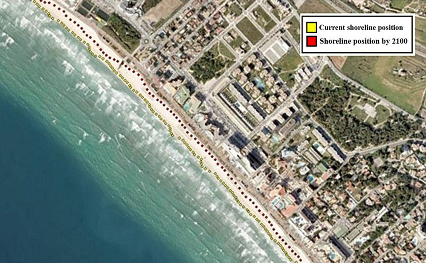
Fieldwork in Ground Zero, Mallorca. A Methodological Fieldwork Proposal for a Geographical Analysis of Tourist Areas

    It is worth outlining the adaptation of methodologies and tools in order to tackle problems related
to global change like the local population’s loss of their everyday habitats due to climate change, the
depletion of fossil fuels, a loss of biodiversity, and crossed biophysical resilience thresholds (Blanco-
Romero, 2019). The concept of resilience has aroused substantial interest among tourism researchers
seeking ways of dealing with crises, disruptions and changes (Biggs, Hall & Stoeckl, 2011). Socio-
ecological approaches to spatial resilience have been addressed by various authors (Hopkins, 2010; Cork,
2009; Hudson, 2010; Wilding, 2011), with the establishment of new scenarios of social, economic and
environmental stability (Walker, Holling & Carpenter, 2004). Through this kind of socio-ecological
approach, fundamental importance is lent to conservation, balanced ecosystems, and quality of life, while
boosting the local community’s participation in governance of the territory, as well as promoting equitable
access to resources and services (Amat, 2013).
    Our paper wishes to fill a gap in the use of fieldwork by taking advantage of field trips to analyse the
links between tourism and global change. From a theoretical point of view, we intend to demonstrate the
usefulness of fieldwork, contributing to epistemological recognition of its conceptual framework and
using spatiality, a concept embedded in fieldwork learning, to reinforce the acquisition of skills, tools and
conducive attitudes to global change. Our ultimate goal is to offer a series of theoretical considerations
and a useful model for teachers and researchers. In theoretical terms, we agree with Büscher and Fletcher
(2020) in their defence of a political ecology approach, centred on a critique of contemporary capitalism
that can shift debate on the Anthropocene onto more realistic ground. Global change in the Anthro-
pocene calls for alternative realistic approaches, based on–but not confined to–past experience; that is,
rooted in tangible historical experience but also taking into account imaginative solutions (Wark, 2015).
Because global catastrophes, like the COVID-19 pandemic, force us to acknowledge the fact that, even
today, we still face high levels of social inequality, growing environmental degradation and economic stag-
nation, the search for post-growth, post-capitalist, post-development alternatives has become a social and
intellectual imperative, for instance through genuine, fair degrowth (Fletcher, Murray, Blanco-Romero &
Blázquez-Salom, 2019). In addition to all the above, through the design of some experimental procedures
to incorporate in fieldwork practices, we contribute to possible methodological advances.

2. Methodology
    This paper aspires to help establish why and how fieldwork learning activities can be used to analyse the
relationship between tourism and global change. To do this, a summarized review was made of the theory
and practical application of fieldwork to tourism geography. First, we studied the underlying theoretical
framework that supports its usefulness, particularly as a teaching tool in university studies and in
analysing the links between tourism and global change during the Anthropocene. Second, methodological
guidelines were drawn up to plan the use of field trips in teaching, based on scientific analytical methods.
Finally, the applicability of fieldwork to analyses of tourist areas of Mallorca was illustrated.
    Our hypothesis is that fieldwork is a particularly suitable tool for developing the following compe-
tences and skills in students, tying in the theory studied in the classroom with the real world (France &
Haigh, 2018): a) improved student autonomy in analysing realities, facilitating the acquisition of mean-
ingful knowledge; b) a raised environmental awareness and desire to seek a solution to the global changes
brought about by humankind during the Anthropocene; and c) an insight into reality through direct
contact with it as a means of tackling current socio-ecological problems.
    Furthermore, when fieldwork is used in teaching, students engage in problem solving and they boost
their capacity for critical thinking (in keeping with France and Haigh, 2018), exploring how to address
and manage the impacts of global change on coastal tourist destinations. We use examples of popular mass
tourism resorts, detailing the activities and input to be worked on during the field trips. These proposed
methodological ideas have been tested out many times during the last three decades with hundreds of un-
dergraduate and postgraduate tourism, geography and teacher-training students, not just from Spanish uni-
versities but also from other European ones (Switzerland, Germany, the Netherlands, etc.). We take advan-
tage of this experimental design to work on learning objectives transposable to other contexts, dealing with
the links between tourism and global change. In addition, we propose a specific practical exercise aimed at
analysing tourism’s relationship with the global changes brought about during the Anthropocene; that is,
the effects of rising sea levels due to global warming, changes in land use, and urban and tourism planning.

Investigaciones Geográficas, nº 75, pp. 43-59.                                                                         47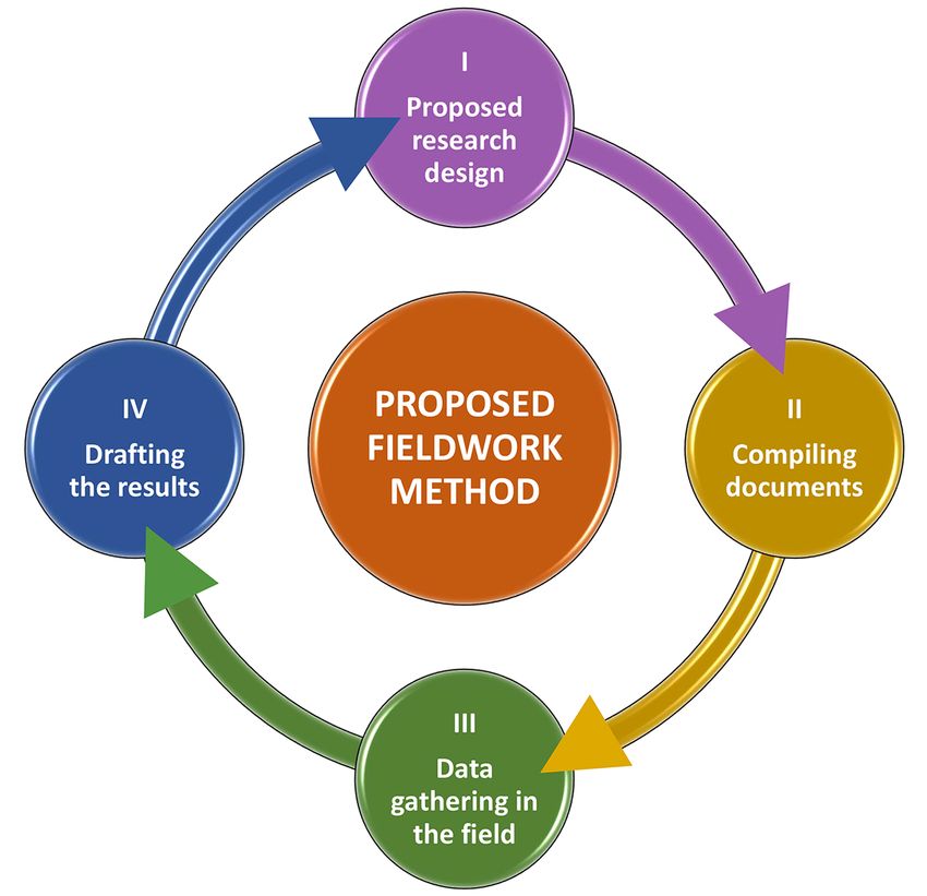
Blázquez-Salom, M. and Blanco-Romero, A.

3. Results
    From reflections on teaching theory and practice, a series of general conclusions were reached on
how fieldwork can contribute to the teaching of tourism geography within the framework of the Anthro-
pocene, focusing on: 1) how to adapt hypothetical-deductive procedures to fieldwork planning methods;
2) the organization of fieldwork activities; and 3) the role of the teacher and students in the implemen-
tation of activities.
    A practical example of the proposed methodology is given in section 5.

3.1. The characteristics of fieldwork and its usefulness
    For fieldwork to be used as a means of understanding and analysing certain realities, some preliminary
steps and guidelines are needed. In the planning of learning activities to back up theory (e.g. tourism
geography lectures) and in academic research (such as final or master’s degree projects or doctoral
theses), a method must first be established, defining the main premises, sources of information and data-
processing procedures (see Figure 1).

                             Figure 1. Main steps in the proposed fieldwork method

                                                Own elaboration

    It is important to start by deciding whether to use a quantitative, qualitative or mixed methodology,
analysing to what extent each one will guarantee data of a sufficiently high standard to meet the established
objectives and for meaningful conclusions to be reached. The most common steps in fieldwork are:
    I. To identify or propose a research topic and to formulate a hypothesis. These are key aspects, re-
          quiring a state-of-the-art analysis to build up in-depth information on the subject. In other words,
          substantial preliminary efforts must be dedicated to collecting, reading and systematizing existing
          published information.
    II. To compile documentary information prior to the field trip, e.g. literature on the subject, case
          studies, statistics, maps etc.
    III. To observe and collect field data, differentiating among quantitative, qualitative and mixed data.
          This encompasses many possibilities: information and opinions from interviews or surveys,
          physical samples collected for subsequent laboratory analysis, counts, inventories, etc. As
          mentioned earlier, fieldwork involves activities in the field, studying real scenarios which may

48                                                                        Investigaciones Geográficas, nº 75, pp. 43-59.
Fieldwork in Ground Zero, Mallorca. A Methodological Fieldwork Proposal for a Geographical Analysis of Tourist Areas
enrich or even alter the study’s initial premises or posed hypotheses. Through the increased
autonomy and group debate that it fosters, fieldwork contributes to meaningful learning by
validating or amending prior assumptions.
IV. To draft and present the results. A fieldwork trip also includes the students’ defence of the results.
Maps are one of the most comprehensive tools in geographical analyses as representations of
the spatial distribution of social and environmental data. Information from aerial photographs
or satellite images can contribute to the development of thematic maps, drawn up as a result of
the fieldwork. Such data is available through ICTs and websites (like IDEIB, https://ideib.caib.es/
visor/, for Mallorca and the other Balearic Islands), processable using GIS technologies.
3.2. Proposed guidelines for fieldwork
In the case of a hypothetical-deductive methodology–the most commonly used method in social
science research–the guidelines (Cloke et al., 2004; Clifford, French, & Valentine, 2010) to follow are
shown in Table 2.
Table 2. Guidelines for a hypothetical-deductive methodology in social science
Steps to follow
1 Delimiting the work, study or research topic.
2 Formulating research questions.
3 Defining objectives and hypotheses (e.g. from a problem-based learning perspective).
I 4 Establishing the territorial scope of the study.
Selecting a sample for the study: observational transects–from urban walks along streets to roads or paths
5
crossing wild landscapes–, interviewing people, conducting questionnaires, etc.
Drafting a methodological guide and outlining the procedures to be followed in order to foster direct
6
observation and/or participative observation.
Preparing a dossier of documents: articles, maps, statistics, etc. This material will be useful if further
7 research on the subject is intended. In teaching activities, this dossier will contain work materials for the
II students doing the fieldwork.
Preparing data-collection sheets; for instance, preparing questions to steer the conversation in the case
8
of in-depth interviews or questionnaires.
The following steps should include the students’ presentation of the results as part of the evaluation
process.
III 9 Data-collection in the field. Through observation by the participants, information and opinions of
many kinds (qualitative and quantitative data) can be collected in different ways (interviews, surveys or
physical sampling, counts, inventories, etc.) for subsequent processing in the laboratory.
Storage and systematic pre-processing of the samples and collected data. For instance, extracting data
10
from interviews or questionnaires.
Processing the qualitative or quantitative data collected in the field, using statistical or computer processing
11 programmes; i.e. ATLAS.ti, SPSS, or simply spreadsheets. An example of quantitative data-processing is
the establishment of correlation patterns or even explanatory factors for a set of collected variables.
12 Using the collected materials to make generalizations.
13 Making thematic maps of the detected data and phenomena.
IV
Discussing the validity of the hypotheses and corroborating, ratifying or rejecting them, comparing them
14
with known theories.
15 Reaching conclusions with regard to the established the objectives.
Finally, if the research has applied purposes, proposals for action, aimed at improving or altering the
analysed reality through a problem-solving approach. In the field of spatial tourism planning, for instance,
16
the purpose of applied geography is to contribute to the design of public policies able to mitigate the
problems of the Anthropocene, such as socio-spatial restructuring processes following the COVID-19 crisis.
Own elaboration
When these guidelines are put into practice, participatory methods will be required, where students
assume an autonomous role in learning.
Investigaciones Geográficas, nº 75, pp. 43-59. 49Blázquez-Salom, M. and Blanco-Romero, A.
3.3. Organizational teaching models
In accordance with the classification by France and Haigh (2018) shown in section 1.2, the aim of
this paper is to focus on activities that foster student autonomy. Teachers play a decisive role in types of
student involvement, and inquiry-based approaches are useful in fostering student autonomy. This calls
for the design of a teaching process that features different levels of student responsibility and involvement
in their own learning process at an individual and group level.
For example, if the fieldwork is aimed at identifying and analysing the spatial pattern of certain An-
thropocenic processes, some basic indications by teachers will be needed. There are various ways of doing
this but, in this case, we offer students a series of basic conceptual ideas for locating a case study and the
basic data needed to analyse it. The steps in the educational process are shown in Table 3.
Table 3. Educational steps in geographical fieldwork
Aspects to be considered
1 The establishment of a basic conceptual framework by teachers.
2 The assignment of aspects to be worked on or subtopics to each group of students.
Reaching an agreement on each study group’s different levels of involvement (e.g. prior preparation by everyone,
3
peer explanations, etc.).
Reaching a decision on the evaluation criteria for the whole process (preparation, execution, defence of the
4
results) and making these criteria known.
Preparing basic qualitative and quantitative sources of information for the students to consult as essential
5
secondary sources in their diagnosis of their topic.
The teachers’ preparation of the basic logistics for the fieldwork activity and its organization, structure, deadlines,
6
etc. An explanation of all this to the students.
7 Defining and agreeing on the work to be done by each group and on each topic.
Strategies for the presentation of each group’s work to the other students, with the option of peer assessment, or
8
the inclusion of possible stakeholders or interest groups in the process.
Own elaboration
Through clear planning of the above steps, it is possible to agree on different stages in the fieldwork,
deciding on the places and even the times for each of the presentations of different topics by the groups.
During the field trip, at each stage or stop on the route, although the teacher might give basic indications,
each of the study groups is responsible for explaining what they have prepared to the other students,
using whatever materials they deem appropriate. The teacher fulfils a double role, as a guide in the field-
work while also providing any complementary information that might have been overlooked. They will
never be the main protagonist.
Once the allotted time for each topic and visit has come to an end, the groups should be allowed to
work on their own in the field, completing their research with whatever methods they deem necessary:
direct participative observation, individual interviews, field notes, a photographic report, etc.
Through this type of design, several related variables (scale, time, the complexity of a problem) can be
modified. Thus, depending on the available time or the potential places that can be visited and surveyed,
the level of detail and the complexity of the topic to be worked on can be modified. Cooperative work by
different groups of students enriches the process for all of them and it opens up the possibility of alter-
native fieldwork designs. A design covering a wide range of topics is possible, albeit working at a basic
level to facilitate a broad holistic knowledge, complementing some topics with others. In contrast, if more
time is available or the possibility of several thematic field trips is offered, each group can present their
subject in greater depth within a general common framework. Work on complementarity, interrelations
and holistic analyses can be carried out at subsequent sessions, when each group looks for synergies and
the teacher supervises these interrelations, suggesting or facilitating them if necessary. This is when the
necessary sources should be outlined for the completion of a final task for the teacher or social agents,
whether it is an oral presentation, project, report or poster.
3.4. Applying the proposed guidelines to a practical exercise
Our proposed methodology shows how field trips can be organized by applying hypothetical-deduc-
tive analytical methods. It fosters a series of skills, aimed at boosting student autonomy and promoting a
50 Investigaciones Geográficas, nº 75, pp. 43-59.Fieldwork in Ground Zero, Mallorca. A Methodological Fieldwork Proposal for a Geographical Analysis of Tourist Areas
raised environmental awareness in order to tackle problems associated with human-driven global change,
bringing students into direct contact with reality in a meaningful learning process.
Through a practical exercise, we demonstrate how fieldwork can be applied to a set of previously
established topics: 1) the interrelations between increasing fuel consumption by tourist air traffic, global
warming, rising sea levels and beach management, bearing in mind that beaches are key assets for mass
sun and sand tourism; 2) changes in land use at tourist destinations that result in urban sprawl, such
as extensions to airports and the restructuring of the built environment; and 3) the role of regional and
urban planning in tackling global change.
We apply the guidelines outlined above to a real case study of Mallorca. As a first step, the teacher
must give the students a general description of the case study, an outline of the theoretical framework and
details of the research sources and methodology.
3.4.1. General description of the case study and the theoretical framework
Insularity limits the availability of resources, accentuating the problems of the Anthropocene. Mallor-
ca is a good example, and its inhabitants have reacted to these constraints by calling for a curb on urban
tourism growth (Valdivielso & Moranta, 2019). Large airports close to mass tourism resorts highlight
the link between aviation and rising sea levels. Several related topics can be used in fieldwork, such as
how to manage sustainable beach tourism, given the threat of rising sea levels; or the interpretation of
land uses (urban sprawl toward the island’s remaining wetlands and its coastline) for the restructuring
of accommodation and transport facilities, particularly the airport; or the regulation of land uses at an
urban and regional level.
For the teaching activity, coastal tourist resorts are used in order to explore what changes might be
made to deal with current scenarios of global change. In this case, the factors to consider are the changes
brought about by the 2020 COVID-19 pandemic. At a hypothetical level, these tourist destinations face
similar problems, due to a combination of rising sea levels, growing travel problems for health reasons,
and fuel constraints for air traffic.
Mallorca has 301,000 tourist beds in hotels and tourist apartments of varying kinds (Agència d’Estratègia
Turística de les Illes Balears [AETIB], 2019). This does not include the housing accommodation used
for tourism purposes, which has given rise to a process of commodification. This share is estimated as
accounting for 101,215 beds, based solely on accommodation marketed by Airbnb (https://twitter.com/
terraferida). Beaches are the island’s main tourist attraction, and the biggest tourist resorts are located close
to them. There is an estimated ratio of 1.68 m2 of beach per tourist bed, based on the useful surface area
of all the island’s beaches and the peak tourist season (with a peak of 1,477,157 tourists in 2017), while
the optimum ratio would be 15m2/person (Consell Insular de Mallorca, 2018). To tackle the problem
of overtourism, plans and laws have been passed at a regional spatial planning level directed at curbing
tourist beds (Blázquez-Salom, Blanco-Romero, Vera-Rebollo, & Ivars-Baidal, 2019) and at managing the
coastline, with particular attention to beaches (Mir-Gual, Pons, Roig-Munar, & Martín-Prieto, 2012).
For this small island, with visitor numbers of nearly 12 million tourists in 2018 (AETIB, 2019), the
COVID-19 crisis will once again lead to the destruction and restructuring of wealth, temporarily over-
coming some of the impacts and then leading to a new stage of capital circulation and accumulation
(Murray et al., 2017). Prior to the COVID-19 outbreak and the ensuing crisis, the company that runs
the airport under a public-private partnership called for its extension from a current capacity of nearly
30 million passengers in 20183 to a scenario of 34 million in 2025 (Dirección General de Aviación Civil,
2020). As far as aviation emissions are concerned– the main source of greenhouses gas emissions for the
world tourism industry (Lenzen et al., 2018)–, the airport’s proximity to big tourist resorts is a useful
teaching resource in fieldwork.
The urban beaches typically associated with mass tourist resorts are correlated with the highest ero-
sion rates (Martín, Carreras, Pons & Almaraz, 2020). This is due to their artificialisation through the
construction of buildings and promenades on dune systems, infrastructure on the beach itself, sand
cleaning machines, and changes to the longshore drift linked to the construction of new marinas that act
as a sediment traps (Martín et al., 2016). The evolution of Mallorca’s busiest beaches, Platja de Palma and
Cala Millor, has been surveyed using topo-bathymetric sampling, wave gauge monitoring and shoreline
3 Air traffic statistics by AENA, available online http://www.aena.es/csee/Satellite?pagename=Estadisticas/Home
Investigaciones Geográficas, nº 75, pp. 43-59. 51Blázquez-Salom, M. and Blanco-Romero, A.
variation mapping inferred from video monitoring stations. The results indicate a coastal retreat of 7 to
50 metres, equivalent to half the present-day aerial beach surface, according to 21st century sea level
and wave projections under considered climate scenarios (Enríquez, Marcos, Álvarez-Ellacuría, Orfila &
Gomis, 2017). These selected beaches are located in built-up areas, backed by walls, with limited possi-
ble landward migration of the shoreline. The COVID-19 health crisis has forced the public authorities
to limit the number of visitors to beaches, with the recommendation of mechanical sand screening or
sieving systems (Ministerio de Sanidad, 2020). From a tourist point of view, these two resorts are typical
examples of coastal mass tourist destinations.
Platja de Palma is the most important tourist resort in the Balearic Islands, dating back to the 1960s. It
stands close to the island’s airport, with nearly 50,000 tourist beds (Yrigoy, 2014). Cala Millor is a tourist
resort initially developed in the 1990s (Pons, Rullan, & Murray, 2014), later than Platja de Palma due to
its distance of 70 km from the airport. This second area is characterised by hotels with a total capacity of
28,400 beds, according to the Balearic Tourist Accommodation Catalogue (CAIB, 2015), surrounded by
the Son Moro and Port Verd districts.
3.4.2. Research sources and the methodology for the practical exercise
The exercise begins with the field trip’s design in the classroom, establishing the procedures and other
aspects. In accordance with our proposed guidelines and emphasis on student autonomy, the students
must be involved in the design instead of listening to explanations, as occurs with other staff-led activities.
This means that a dossier must first be prepared with articles, maps, statistics and so on, together with a
research aide-mémoire. For this study of Mallorca’s tourist resorts, the teachers will outline some available
resources: previous studies of the areas (Yrigoy, 2015, Casañas, 2017; Enríquez, et al., 2017), cartographic
viewers (https://ideib.caib.es/visor/), statistics (AETIB, 2019; http://www.aena.es), urban and tourism
planning data (Consell de Mallorca, 2015; Consell de Mallorca, 2020), etc.
To analyse the links between tourism and global change, for our case study of Mallorcan tourist
resorts, the following steps were defined: the formulation of a hypothesis, the preparation of a detailed
dossier including sources of information (data collection), and the definition of research methods, such
as participatory observation or mapping. For instance:
• To work on the topic of beach management, a hypothesis must be formulated on the interrelations
between tourist air traffic, global warming, and rising sea levels. For example, substantial statistical
data can be found on the correlation between concentrations of CO2 in the atmosphere, tempera-
tures, rising sea levels and their effect on the analysed beaches (Figures 2 and 3).
Figure 2. Present-day shoreline (in yellow) and landward migration (in red) in the worst-case scenario by the end
of the 21st century in Platja de Palma
Source: Enríquez et al., 2017
52 Investigaciones Geográficas, nº 75, pp. 43-59.Fieldwork in Ground Zero, Mallorca. A Methodological Fieldwork Proposal for a Geographical Analysis of Tourist Areas
Figure 3. Tourist use of Platja de Palma beach
Source: Macià Blázquez-Salom, July 28th 2019. Own elaboration
•T o study beach management, data or samples collected in the field can be related to aircraft move-
ments at Palma Airport as the generators of greenhouse gases; surveys can be conducted of visitor
numbers to beaches (Figure 3); or hotel managers can be interviewed to find out their concerns
regarding the environment, the island’s shrinking beaches etc.
• To study changes in land use, participatory observation is one of the most effective methods in
fieldwork research, as with the above study of coastal management. The students should be asked
to design surveys in order to boost their autonomy (e.g. surveys of groundwater levels and the
quality of the water, or biodiversity inventories of the remaining wetlands, threatened by urban
sprawl and extensions to the airport). By contrasting coastal management documents and the de-
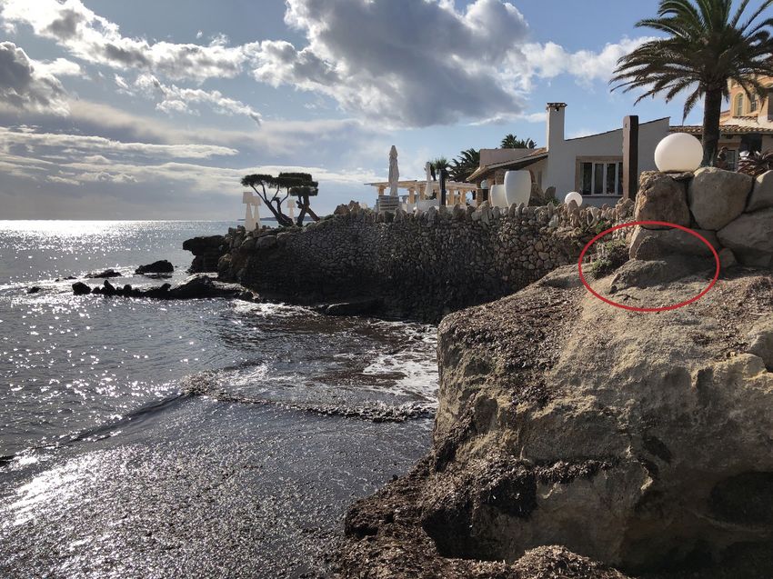
marcation of the coastline shown in them with the reality (Figure 4), group debates can be fostered
which contribute to meaningful learning by validating or correcting assumptions.
Figure 4. Waterfront boundary marker (the small pyramid circled in red in the picture) at Port Verd. Despite this, the
terrace of a beach club prevents public access to the coast.
Source: Macià Blázquez-Salom, September 8th 2019. Own elaboration
Investigaciones Geográficas, nº 75, pp. 43-59. 53Blázquez-Salom, M. and Blanco-Romero, A.
• Maps are a good example of the materials that can be created as a result of fieldwork. Student au-
tonomy can be boosted by analysing geographical patterns for the three selected topics. Mapping
can be done directly, e.g. by mapping the area occupied by a beach or the infrastructure needed to
manage it (Figure 5); the distance between the waterfront and different land uses, such as residen-
tial uses (Figure 6) or tourist accommodation; or air traffic arrival and departure flows.
Figure 5. Concrete blocks used to prevent the erosion of Cala Bona beach
Source: Macià Blázquez-Salom, September 8th 2019. Own elaboration
Figure 6. The proximity of the waterfront to residential land uses, with less proximity in the case of tourist
accommodation due to the demand for more available public space on beaches
Source: Macià Blázquez-Salom, September 8th 2019. Own elaboration
ieldwork is particularly useful in analyses of changes in land use in the built environment. Platja
•F
de Palma and Cala Millor are both designated mature tourist resorts for regional planning purposes
due to their congestion, with a high density of tourist beds, environmental degradation and ob-
solete buildings and infrastructure. This designation was applied after the 2008 crisis to allow for
the restructuring of hotel facilities and to relax certain urban planning constraints. The COVID-19
pandemic has served to reinforce these policies, prioritizing short-term results instead of trying to
mitigate or adapt to the effects of global change.
54 Investigaciones Geográficas, nº 75, pp. 43-59.Fieldwork in Ground Zero, Mallorca. A Methodological Fieldwork Proposal for a Geographical Analysis of Tourist Areas
inally, fieldwork can be used in studies of urban and tourism planning to identify hotel buildings
•F
that have recently been or that are still being adapted or refurbished in accordance with new
regulatory frameworks aimed at facilitating their modernization or new system of management
through the creation of condo-hotels or their conversion into apartments. In the case of Platja de
Palma, a new Integral Restructuring Plan was approved in 2015 as part of a political commitment
to tackle the 2008 systemic crisis (Yrigoy, Artigues & Blázquez-Salom, 2013 and 2015). This
urban planning instrument’s detailed maps can be used as a source of information to understand
spatial restructuring process, such as changes in the use of hotels or new urban sprawl due to
new development projects approved as a result of the former crisis. Even though this urban area
is located on a coastal system of sand dunes, a restinga or a coastal ridge between the wetland and
the sea, this instrument does not take climate change into consideration at all.
4. Discussion
The fieldwork proposed in this article, based on specific examples and exercises, helps to foster learn-
ing skills, thus confirming our initial hypothesis where we defend fieldwork’s contribution to scientific
headway in tourism geography. Our teaching experience corroborates the following: a) improved student
autonomy in analysing realities, thus facilitating meaningful learning b) a raised environmental aware-
ness in order to tackle the problems of global change brought about by humankind during the Anthropo-
cene; c) the capacity to explore realities, through direct contact in the field, and hence to contribute to a
search for solutions to the current socio-ecological scenario.
Thus this paper has confirmed the usefulness of fieldwork in enriching how the conceptual and
theoretical rudiments of tourism geography are taught, further to what other authors have already
said (France and Haigh, 2018; Kent et al., 1997; Martínez and Yubero, 2020). In fieldwork, the basic
criteria developed by Kent, Gilbertson & Hunt (1997) for classifying learning criteria can be applied,
promoting student autonomy and management of their own role in learning. Fieldwork also contributes
to the learning methods defined by France and Haigh (2018), based on teamwork and project-oriented,
enquiry-based approaches that connect theory and practice. This problem-based learning (PBL) process
encourages independence and a critical analysis of realities (Pawson, et al. 2006; Thomas, 2009). The
design of practical guidelines, such as ours, can be used to promote meaningful learning (Torrisi-Steel,
2009), fostering autonomous and participatory learning competences and skills where students take
responsibility for what they learn.
The tourist industry shuns any reference to links between tourism and global change, upholding
virtues such as the generation of enjoyable leisure experiences. In this context, tying tourism in with
the Anthropocene is a useful teaching exercise that promotes greater sensitivity to nature and an active
interest in trying to find a solution to the socio-ecological problems caused by humankind (Prince, 2020).
The COVID-19 pandemic demonstrates human dependence on conserving an ecological balance even
more strongly (Gibb, et al., 2020).
By using fieldwork to explore realities, following the guidelines established in this paper, students can
take responsibility for research. As a teaching strategy, fieldwork puts students into direct contact with
real situations (Santiago, 1998), allowing them to interpret and analyse them from a scientific perspective
(Sánchez & Godoy, 2002) in a meaningful learning process where practice is given in the cognitive pro-
cesses needed for problem-solving tasks (Torrisi-Steele, 2009). As we show, direct observation offers an
opportunity to gain an insight into the realities of tourism geography and the problems of the Anthropho-
cene. In our experience, students are capable of testing hypotheses, explaining geographic phenomena
and coming up with proposals to tackle problems, through methods such as urban and regional planning.
5. Conclusions
Through in-depth, rigorous tests of the proposed fieldwork methodology with our students, we were
able to ratify our initial hypothesis. We demonstrate fieldwork’s usefulness, particularly in studying the
links between tourism and the Anthropocene at mass tourist destinations. The methodology –which
we apply to Mallorca as a case study, although it can equally well be transposed to other geographical
settings– demonstrates fieldwork’s effectiveness in encouraging students to take responsibility for what
they learn in meaningful contexts and in fostering an awareness of humankind’s responsibility for finding
Investigaciones Geográficas, nº 75, pp. 43-59. 55Blázquez-Salom, M. and Blanco-Romero, A.
a solution to the crises of the Anthropocene, in addition to highlighting the usefulness of direct contact
with realities as a means of gaining a better understanding of them.
In terms of our initial aims, we have achieved our first aim by demonstrating that fieldwork can
contribute to analyses of the relations between tourism and the Anthropocene, helping to test out
theories through a comparison with real situations. For this group activity, where the spotlight is cast on
the role of the students, many possible topics can be studied, such as global warming processes caused by
fossil fuels and the ensuing consequences on sea levels and beach management, given the importance of
beaches in mass sun and sea tourism.
As for our second aim, the design of methodological tools to enrich fieldwork activities, hypothetical-
deductive methods are scientifically sound, useful means of analysis in tourism geography and our
guidelines can be extrapolated to similar teaching and learning processes. Fieldwork helps to develop
different skills and competences, such as observation, analysis, summarization, autonomy, sampling
techniques and the general application of acquired knowledge (Torrisi-Steele, 2009), in our case instilling
an interest in the link between global change and tourism.
Our third aim was to test the practicality of our proposed methodology by applying it to a case study,
specifying the steps to be taken, based on the practical guidelines in Table 2. This allowed us to test out
a conceptual design where theoretical knowledge can be contrasted with the spatio-temporal realities
of spatial construction through diachronic processes. Through the fieldwork activities, encounters with
stakeholders can be facilitated, a holistic vision can be gained of complex phenomenon, and important
insights can be achieved into situations occurring on the Earth’s surface at a spatial level, in addition to
spatial disparities, changes and possible causal interrelations.
One limitation of our proposed methodology is the role of the teacher. Paradoxically, giving the stu-
dents greater responsibility calls for more commitment on the part of the lecturer, since greater dedication
is needed than in the classroom. The teacher is no longer the transmitter of conceptual information but a
guide who mediates in a meaningful learning process. As the main responsibility for the learning process is
delegated to the students as individuals and as groups, multiple-criteria assessment methods must be used.
A second aspect to consider in future research is the level of assimilation of learning outcomes. The
acquired skills can be evaluated through improvement indicators and criteria like the application of the
developed methods, employability, etc. In future research, a detailed study should be made of the appli-
cation of our proposed learning experience to groups of undergraduate students.
Lastly, the uncertain economic consequences of the COVID-19 crisis are having huge socio-spatial
repercussions on mass tourist destinations, like Mallorca, an island that can be considered a Ground Zero
in this crisis. Within this context, fieldwork is an all-important tool in teaching tourism geography and in
analysing the restructuring of tourist resorts within the framework of the Anthropocene’s human-driven
changes.
Funding
This research contributes to the projects: “Overtourism in Spanish Coastal Destinations. Tourism
Degrowth Strategies” (RTI2018-094844-B-C31) and “Inland tourism in Spain: Challenges, valorisation
and strategies in the face of changing situations and crises for boosting tourism products and destinations.
Case dynamics” (CSO2016-74861-R), State R+D+I program oriented toward society’s challenges, Minis-
terio de Ciencia, Innovación y Universidades, Agencia Estatal de Investigación and European Regional
Development Fund of the European Union.
References
Agència d’Estratègia Turística de les Illes Balears (AETIB) (2019). El turisme a les Illes Balears. Anuari 2018.
Palma (Mallorca): Agència d’Estratègia Turística de les Illes Balears, Vicepresidència i Conselleria
d’Innovació, Recerca i Turisme. Govern de les Illes Balear. Retrieved from http://www.caib.es/sites/
estadistiquesdelturisme/ca/anuaris_de_turisme-22816/archivopub.do?ctrl=MCRST865ZI290987&id=
290987
Antolín, J.E. (2019). El ecologismo en la época de la pospolítica. Del ecologismo militante al emocional:
límites estructurales del discurso ecologista. Ecología Política, 58, 19-26.
56 Investigaciones Geográficas, nº 75, pp. 43-59.You can also read