Dating the landscape evolution around the Chauvet Pont d'Arc cave - Nature
←
→
Page content transcription
If your browser does not render page correctly, please read the page content below
www.nature.com/scientificreports
OPEN Dating the landscape evolution
around the Chauvet‑Pont d’Arc
cave
Kim Genuite1,6*, Jean‑Jacques Delannoy1,6, Jean‑Jacques Bahain2,6, Marceau Gresse3,6,
Stéphane Jaillet1,6, Anne Philippe4,6, Edwige Pons‑Branchu5,6, André Revil1,6 &
Pierre Voinchet2,6
The Chauvet cave (UNESCO World Heritage site, France) is located in the Ardèche Gorge, a unique
physical and cultural landscape. Its setting within the gorge—overlooking a meander cutoff containing
a natural arch called the Pont d’Arc—is also remarkable. Investigating possible associations between
sites’ physical and cultural settings, chronologies of human occupation, and access conditions has
become a major theme in archeological research. The present study aims to reconstruct the landscape
of the Pont d’Arc meander cutoff during the Upper Paleolithic, when humans were present in the
Chauvet Cave. We used uranium-series and electron spin resonance analyses to date the formation
of the Pont d’Arc natural arch in the Combe d’Arc meander cutoff, near the Chauvet Cave. Results
show that the meander became totally cutoff between 108 and 138 ka (95%). Hence, the natural arch
formed before the Upper Paleolithic and the first known human presence in the Chauvet Cave, dated
to 37 ka cal BP. These results allowed us to reconstruct a key part of the landscape surrounding the
Chauvet Cave when it was being used by Upper-Paleolithic societies.
The fact that many major rock art sites are located in highly distinctive landscapes has led archeologists, eth-
nologists, and ethno-archeologists to explore potential links between landscape features and their symbolic
usage1–5. The study of the physical context of the archaeological sites is of particular importance for expanding the
interpretive horizons of the location of ancient societies and their interactions with living spaces. An increasing
number of studies now focus on the restitution of site morphologies during their frequentation6–11. The main
gaps in understanding concerns either the external geomorphological processes involved in the evolution of
the external context of a site, the chrono-stratigraphic relationships between the deposits present on excavated
sites and its surroundings, and the lack of integrated studies linking the information gathered on a site with its
direct environment12.
The Chauvet cave benefited from such integrated geomorphological studies and cave morphologies could be
reconstructed at different stages before, during and after the human f requentations9. The Chauvet cave Upper-
Palaeolithic artwork was dated back to 37 ka cal. BP, and showed two main periods of frequentation at 37-33.5 ka
cal. BP and 31–28 ka cal. BP r espectively13. Its artwork characteristics and the antiquity of the radiocarbon ages
made this cave a reference for the beginning of the Upper-Palaeolithic worldwide (UNESCO World Heritage).
Exceptional artwork preservation is related with a series of rockfall events between 23 and 21 ka that blocked
the Palaeolithic cave entrance, thereby preventing further access to the cave and preserving its p aintings14.
Such work contributed to highlight landscape evolution as an effective approach to contextualize archaeological
research. However, previous studies have focused almost exclusively on the cave and its entrance, rather than
its surroundings. Here we study the landscape evolution in the vicinity of the Chauvet Cave (Ardèche Gorges,
France). In fact, the cave sides with numerous other Upper Paleolithic s ites15 that lie around and inside the cliffs
of the Cirque d’Estre, a meander cutoff that hosts a 30 m high limestone arch, called the Pont d’Arc, which spans
1
Laboratoire Environnements Dynamiques et Territoires de Montagne, UMR 5204, CNRS, Savoie Mont Blanc
University, Campus scientifique, Bat. Pôle Montagne, 73376 Le Bourget‑du‑Lac cedex, France. 2Histoire
Naturelle de L’Homme Préhistorique, UMR 7194, CNRS, MNHN, UPVD, 1, rue René Panhard, 75013 Paris,
France. 3Earthquake Research Institute, University of Tokyo, Tokyo 158‑8557, Japan. 4Laboratoire
de Mathématiques Jean Leray, Nantes University, 2, rue de la Houssinière, BP 92208, 44322 Nantes,
France. 5Laboratoire Des Sciences du Climat Et de L’Environnement, UMR 8515 CEA, CNRS, UVSQ, Orme
des Merisiers, Bat 714, Chemin de Saint Aubin – RD 128, 91191 Gif sur Yvette cedex, France. 6These authors
contributed equally: Kim Genuite, Jean-Jacques Delannoy, Jean-Jacques Bahain, Marceau Gresse, Stéphane Jaillet,
Anne Philippe, Edwige Pons-Branchu, André Revil, and Pierre Voinchet. *email: kim.genuite@gmail.com
Scientific Reports | (2021) 11:8944 | https://doi.org/10.1038/s41598-021-88240-5 1
Vol.:(0123456789)
www.nature.com/scientificreports/
Figure 1. Location of the Chauvet Cave. The Chauvet Cave is in the Cirque d’Estre scarp, above the Combe
d’Arc meander cutoff, which formed when the Ardèche River cut through the Pont d’Arc to form a natural arch.
Several Upper-Paleolithic caves have been found in and around a stretch of the Ardèche Gorge, more-or-less
centered round the Cirque d’Estre and Pont d’Arc. 1. Chauvet Cave, 2. Vacheresse Cave, 3. Planchard Cave,
4. Bergerie du Charmasson, 5. Mezelet, 6. Pc du Maquis, 7. Chasserou Cave, 8. Deroc Cave, 9. Fées Cave, 10.
Baume du Bouchon, 11, Ebbou Cave. Photograph from: Jean-Jacques Delannoy.
the Ardèche River at the entrance to the Ardèche Gorges (Fig. 1). The concentration of Upper Paleolithic sites
in such a specific landscape feature questions choice of the site frequentation by the prehistoric p eople16–18. An
essential first step in conducting such analyses is to ascertain whether current features were already part of the
landscape when a site was being u sed9,11. The present study aims to trace the evolution of this landscape in order
to determine whether the meander cutoff and Pont d’Arc had already formed 37 ka cal BP, when the Chauvet
cave was frequented by Upper Palaeolithic societies. The piercing of the natural arch allowed the river to bypass
the meander19. We tried then to date the meander cutoff, as it would indicate when the natural arch formed.
The first step was to carry out a geomorphological survey of the Ardèche gorges entrance. Because of its karstic
context, the study focuses both the external morphological features (alluvial deposits) and sediments found in
the proximate Châtaigniers cave system, located within the meander cutoff (Figs. 1, 2). The Châtaigniers cave was
chosen because of its direct proximity with the Pont d’Arc, and for its range of altitude which corresponded both
to the Pont d’Arc and the lower-level alluvial deposits heights20 (compared to the other surrounding caves), (Fig
2). We determined the surface and subsurface morphologies of the alluvial deposits by combining the results of
topographical surveys with electrical resistivity data conducted inside the cutoff meander. Fieldwork investiga-
tions in the Ardèche canyon entrance led to determine three former river levels, which we labeled T1 (8 m above
the current river base level), T2 (+15 m), and T3 (+30 m). Those observations were compared with the ones inside
the Châtaigniers cave through a unified topographic and stratigraphic model. The comparison of the altitude of
the deposits allowed their integration in a relative chronological model containing alternances of aggradation
phases (coarse fluvial deposits in the river system and laminated clay deposits in the Châtaigniers cave) and
erosion phases (river entrenchment and speleothem growth20. We then tried to date those respective phases.
Because of the quartz-rich component of the Ardèche river s ediments19,21,22, we used paleodosimetric meth-
ods (Electron Spin Resonance – ESR) to date the river d eposits23–27. In cave environment, radiometric analyses
(Uranium series – U-series) are used to date the speleothems growth p hases28–31. The combination of dating
methods in both river and cave environment provides independent constrains that can be discussed through
topographic and chronological correspondences32–36, potentially better constraining landscape evolution dur-
ing the Quaternary period. The use of ESR on fluvial sediments and U-series in karst systems provides absolute
constrains for landscape evolution studies in the Middle and Late Pleistocene.
Similar approaches combining relative and absolute dating of geomorphological objects have been used suc-
cessfully at numerous archaeological s ites11,14,37,38.
Scientific Reports | (2021) 11:8944 | https://doi.org/10.1038/s41598-021-88240-5 2
Vol:.(1234567890)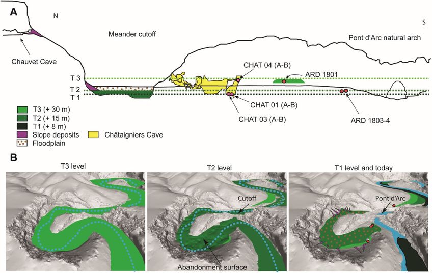
www.nature.com/scientificreports/
Figure 2. Geomorphological map of the Ardèche gorges entrance and sample location. Most of the ESR
samples from the T3 and T2 levels were taken on the Vallon-Pont-d’Arc plain, in road cuttings (Photographs
are reported in the Supplementary Fig. S2). The T1, T2 and T3 altitudes are reported on the Châtaigniers cave
topography for comparison with the speleothem and clay deposits location. Geomorphological map f rom19,
modified. Speleothem photographs from: Kim Genuite.
Site setting. The Ardèche is one of the main tributaries of the Rhône river right bank and is located in the
Massif Central eastern part (Cevennes mountain range). Its 2700 m 2 catchment represents at least one third of
the Cevennes Mountains, which reach 1700 m a.s.l, and extend from South-West to North-East with a mean
altitude of 1200 m a.s.l. The Ardèche upper catchment is incised into plutonic and metamorphic formations.
It then crosses sandstone Trias formation and finishes its course in the Rhône river incising the middle valley
Jurassic sedimentary rocks and finally, the Cretaceous sedimentary rocks in the Ardèche gorges in the shape of
entrenched meanders21. While the upper two third of the catchment are formed by the impervious rocks, the
lower valleys incise carbonate rock shelves which are prone to k arstification39. The Mediterranean conditions
affecting the Ardèche watershed make its hydrological regime prone to flood events40. The Velay lakes constitute
the closest reference palynological sequence for the middle to late Quaternary period41 and shows the impact of
glacial and interglacial phases that may have affected the paleo-hydrological conditions in the Ardèche catch-
ment.
The Vallon-Pont-d’Arc plain is a floodplain located at the entrance of the Ardèche gorges which contains
stepped alluvial deposits19,22, (Fig. 2). The lower fluvial levels are organized parallel to the current rock talweg that
crops out regularly in the river bed. The relative height above the river (RH) of the deposits is consistent through-
out the middle and lower Ardèche valley22. The lower levels are the most visible in the current landscape and we
focus here on the three lower ones (T1, T2 and T3) which have been characterized through geomorphological
mapping and outcrops19, (Fig. 2). At the Ardèche canyon entrance, alluvial deposits are mainly composed of
coarse elements (pebbles and cobbles ranging between 5 and 50 cm) with locally sand lens or sand beds (medium
sands with stratigraphic alluvial features). They are organized as it follows: the T1 level is located at + 8 m (RH)
and is characterised by large cobbles and boulders. Granitic and basaltic large cobbles (0.1–0.2 m) dominate the
petrographic pattern19,22,42. The T1 characteristics is similar to the current alluvial p lain19, Fig. 2). The T2 level
(+ 15 m RH) is also well visible in the three main Ardèche plains. It is characterised by large cobbles (about
10 cm), and a low basaltic c ontent19. The petrographic composition evolution of river terraces is impacted by
both the late Miocene volcanism (Coirons lava) and late Pleistocene one (Bas-Vivarais) which occurred in the
Ardèche catchment43. The current floodplain and T1 level composition are basalt rich, which is not the case for
Scientific Reports | (2021) 11:8944 | https://doi.org/10.1038/s41598-021-88240-5 3
Vol.:(0123456789)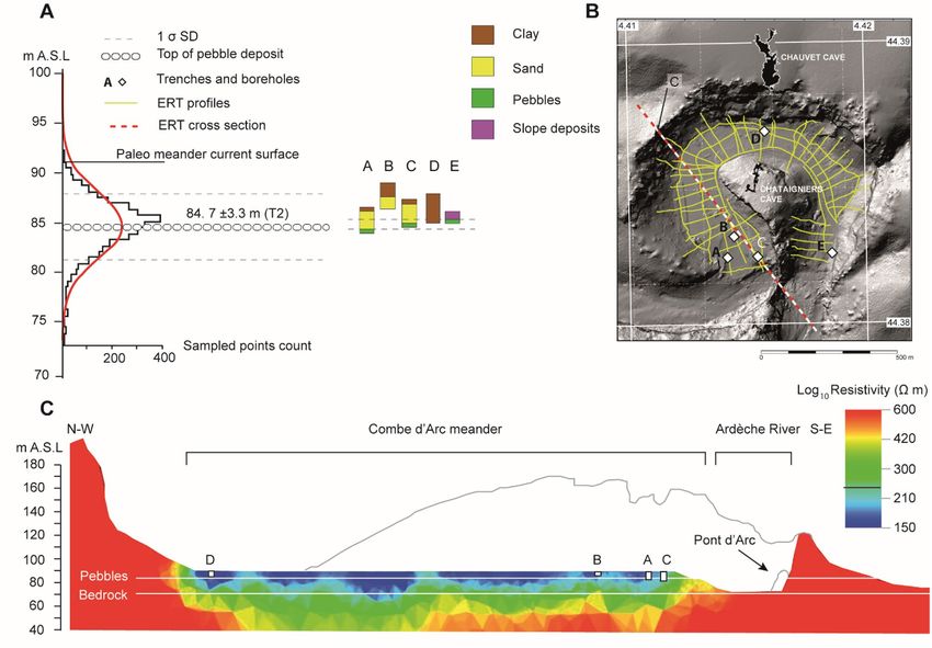
www.nature.com/scientificreports/
Figure 3. ERT survey inside the Combe d’Arc meander cutoff. Resistivity values for the meander sediments
ranged from 150 to 600 Ωm. (A) Mean altitude of cutoff cobble layer. (B) Location of the ERT cross-sections.
(C) Cross-section of the meander cutoff showing resistivity values.
the T2 and T3 levels. Bas-Vivarais lava flows were deposited in the river talweg since between 80 and 30 ka and
were subject to intense e rosion43. The T3 level (+ 30 m RH) is characterized by slightly coarser cobbles than the
T2 level (superior to 10 cm) and have an important spatial extent (Fig. 2). The sand matrix is also slightly more
hardened although this was variable along the outcrops. In situ alteration was observed for about 20 % of the
granite cobbles visible inside the T3 level at numerous outcrops19. This can be related with granite bisiallitisation
into quartz s and44,45, as observed in other rivers in south of F
rance25,46. The released quartz grains are millimetric
to multi-millimetric in size.
The Châtaigniers cave is located in the vicinity of the cutoff meander and in the altitudinal range of the Pont
d’Arc arch and the T1, T2 and T3 fluvial l evels20. Trapped speleothems were visible at the corresponding T1 (+ 8
m RH) and T3 (+ 30 m RH) heights. They were in connection with laminated clay deposits linked with former
water table levels in the cave.
Results
Geophysical prospection. For the +15 m alluvial deposit (T2), boreholes and trenches inside the Combe
d’Arc (Fig. 3) revealed the presence of thin clay layers on top of layers of coarse sand and pebbles. The cobbles
are linked to the last perennial flows through the meander before the cutoff became complete, while the clay is
linked to flood events that occurred later in the cutoff meander40 (Fig. 3). ERT values of 250 Ωm were interpreted
as corresponding to the top cobble deposit inside the meander. Plotting these values gave an altitude of 84.7 ±3.3
m A.S.L (±1 σ SD) across the entire meander, which is 4 to 7 m below the current surface (Fig. 3). This buried
cobble-rich alluvial body indicates the last stage of the meander perennial activity, and thus represents the cutoff
ending phase.
U‑series on speleothems. We obtained U-series ages for samples from three stalagmites (Table 1). CHAT-
03 is a well-laminated, 20-cm-long stalagmite containing clay laminations that suggest that calcite growth was
almost synchronous with the horizontal clay infilling. U-series ratios revealed high levels of detrital thorium that
can be attributed to contamination during regular floods or water table rising within the cave, thereby suggesting
that the speleothem grew concurrently with the deposition of the clay deposits in the cave. The 230Th/232Th ratio
is relatively low, which is in agreement with probable contamination from detrital 232Th during the speleothem
Scientific Reports | (2021) 11:8944 | https://doi.org/10.1038/s41598-021-88240-5 4
Vol:.(1234567890)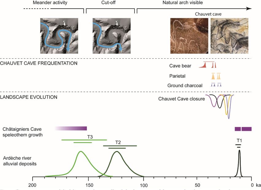
www.nature.com/scientificreports/
Ref Sedimentary unit Lithology Method Age
CHAT-04A Speleothem Calcite U-series 364.24 ± 15.15
CHAT-04B Speleothem Calcite U-series 162.46 ± 5.06
CHAT-03A Speleothem Calcite U-series 15.660 ± 2.91
CHAT-03B Speleothem Calcite U-series 13.170 ± 1.12
CHAT-01A Speleothem Calcite U-series 7.25 ± 1.95
CHAT-01B Speleothem Calcite U-series 2.34 ± 1.54
Table 1. U-series ages. All ages are given in ka, with a 2 σ SD.
grow, which leads to more important age uncertainties, hence the reverse ages obtained for the speleothem
growth (13.2 ±1,12 ka for the bottom and 15.7 ±2.9 ka for the top). The speleothem ages remain close to each
other, and error ranges are slightly overlapped. Such age reversal is acceptable considering the time range aimed
in the study. The CHAT-01 speleothem was sampled on the sides of the laminated clay infilling, in a lateral
eroded part (Fig. 2). U-series delivered ages comprised between 7.25 ±1.95 and 2.34 ±1.54 ka. The relatively low
230
Th/ 232Th ratio of CHAT-01 are also probably linked with detrital inputs (Supplementary Table S6). CHAT-04
is a 25-cm long stalagmite. The calcite appears to be free from clay deposits, suggesting that it grew well above
the river base level, before being covered by clay sediments when the river level rose (Fig. 2). The good 230Th/
232
Th ratio show a probable absence of detrital contamination by high water table periods during the CHAT-04
speleothem growth (Supplementary Table S6). The top of the CHAT-04 speleothem gave a U-series age of 162.5
±5 ka (CHAT-04B). This speleothem was later covered by clay sediments when the river level rose.
ESR on fluvial quartz sediments. We used electron spin resonance (ESR) analyses to determine the ages
of quartz-rich sediment samples from the +30 m (T3) and +15 m (T2) alluvial levels. The samples analyzed
were taken inside the Combe d’Arc meander cutoff and upstream from the meander, mainly on the Vallon Pont
d’Arc plain, which is immediately upstream from the entrance to the Ardèche Gorges (Fig. 2 and Supplementary
Fig. S2).
Samples coming from the T3 level showed more important optical bleaching rates ranging between 60 and
90%, contrary to the T2 level which shows more common values around 50 %.
Preliminarly, Al and Ti-Li burial ages obtained on the six T3 level samples show an age repartition ranging
between 179 and 511 ka. High bleaching rate affect all the samples of the T3 level. Samples taken in sandy matrix
between pebbles show the highest bleaching rates (ARD 1801, 1806 and 1809). Apart from the ARD 1809 sample
which shows important age discrepancy linked with analytic limitations, all the other T3 samples follow the
Multi-Center approach (slower bleaching kinetics for the Al c enters47). Al ages show deviations ranging from
100 to 200 ka compared to the Ti-Li ages for ARD 1806, 1809, 1805 and 1808. Such deviation is however less
important for ARD 1801 and 1802 samples which yield similar Al and Ti-Li ages within the range of 1 sigma SD.
The high bleaching rates affecting all the T3 samples leads to probable age overestimation of the Al centers27,48,
which makes them unreliable for dating the T3 level (See Supplementary Information, Dating section) and
should be considered as maximum age estimations. Nevertheless, Ti-Li centers indicate an effective bleaching
rate and can be considered reliable for dating purpose. Although the ARD 1801 and 1802 Al ages fall within
the range of their respective Ti-Li ages at 1 sigma SD, they are not considered either for dating for homogeneity
purpose. Most of the Ti-Li ages are within the same range (150-200 ka), except for ARD 1801 which delivers
Middle-Pleistocene ages (around 500 ka).
To date the T2 level, two samples were taken directly inside the meander cutoff, in a 4-m-deep natural trench
in the alluvial sands above the pebble surface (ARD 1803 and ARD 1804). The third sample was taken 10 km
upstream, inside the cobble level (ARD 1807). Sediments from this level do not appear to be subject to opti-
cal bleaching, so we have no reason to suspect that the ages we obtained were overestimates (Supplementary
Table S5). Some of the samples yield slightly older ages for Ti-Li centers (ARD 1803 and 1807). While such con-
figuration is uncommon49, the young ages and the high sensibility of Ti-Li centers (low measured values) may
lead to potential Ti-Li age overestimation. Nevertheless, all ages remain close within a range comprised within
a 100-150 ka range regardless of the center. It thereby confirms the suitability of both Al and Ti-Li centers for
dating and that they belong to the same alluvial deposit phase.
Discussion
Combining geomorphological mapping of the sedimentary units in and around the Ardèche River with a geo-
physical survey and absolute dating of sediment samples enabled to reconstruct the evolution of the Pont d’Arc
meander from the Middle Pleistocene to the Holocene (Fig. 4). The following discussion examines the chrono-
logical and stratigraphic relationships between external and underground geomorphological features. Features
are discussed from oldest to youngest.
At the same altitude than the T3 level, the CHAT-04 speleothem growth stopped at 162.5 ±5 ka and was
later covered by laminated clay (Fig. 2). Even if coarse sediments were not discovered in the Châtaigniers cave
system, that deposit is linked with a rising of the water level inside the Châtaigniers cave system20 and is well
above the known Holocene floods of the Ardèche river40. We included the date for when the CHAT-04 speleo-
them stopped growing as a terminus post-quem constraint50 for the age of T3, as the speleothem could not have
Scientific Reports | (2021) 11:8944 | https://doi.org/10.1038/s41598-021-88240-5 5
Vol.:(0123456789)www.nature.com/scientificreports/
Figure 4. Landscape evolution of the Combe d’Arc meander. (A) Cross-section through the Combe d’Arc
meander cutoff showing sampling points for the alluvial deposits and speleothems. T1, T2, and T3 correspond
to the alluvial deposits at + 8 m, + 15 m, and + 30 m respectively. The diagram shows the altitude of the T1 level in
the Combe d’Arc meander cutoff, but this level is not present in this area. 3D reconstruction of the three phases
in the meander cutoff process showing theoretical extents of alluvial deposits (green areas).
continued growing under the T3 water table. The T3 sedimentation phase occurred in all the river system and
display large cobbles that are typical of high-energy hydrological conditions. Such processes might have impacted
the bleaching rates of the sampled quartz s and51,52, but contamination by unbleached quartz grains coming from
in situ weathered granite cobbles remains also possible. Most of the Ti-Li ages from the T3 level are comparable
with the Optically Stimulated Luminescence (OSL) age (142.5 ±9.2 ka) obtained on fluvial deposits located at
30 m RH in the Ranc Pointu 2 c ave53, (Fig. 2). Ranc Pointu 2 fluvial deposits also come from the Ardèche river.
Considering that we are at the end of the river system (relatively low slope and confluence with the Rhône river),
relative heights are comparable before and after the Ardèche Gorges, which allows the stratigraphical attribution
of the Ranc Pointu 2 OSL age to the T3 l evel22.
The Middle Pleistocene age of the ARD 1801 sample questions an eventual local reworking of fluvial deposit
coming from more ancient levels, or a long-term stability of the T3 level during the middle Pleistocene period.
Nevertheless, the addition of the OSL age with the ESR Ti-Li ages (n = 6) produced an estimated Bayesian age
of between 136 and 176 ka (95%), with a mean value of 158 ka, that is, during Marine Isotope Stage (MIS) 6
(Supplementary Table S7). In the Combe d’Arc, subsequent erosion has removed most of the cobble layers that
formed at the top of T3, but the meander still contains remnants of these deposits (Fig. 4). Their perched posi-
tion indicates that they were eroded by the river that passed through the old meander. Because the Pont d’Arc
natural arch and the T3 alluvial deposit are at almost the same altitude, the cutoff could not have started before
the T3 level formed.
In order to constrain the T2 age, we used the Al and Ti-Li ages of the 1803, 1804 and 1807 ESR samples (n =
6) extracted from sand deposits that correspond to that sedimentation stage. T2 deposits contain few basalt frag-
ments, whereas T1 deposits and the current alluvial plain contain a lot of basaltic material, probably derived from
the Coirons lava (dated to between 8 and 5.5 M a54), and the Bas-Vivarais lava (dated to the late-Pleistocene43). All
ESR ages from the T2 alluvial formation indicate deposition prior to 91 ±13 ka, which is in good agreement with
the dates of the last volcanic phases in the Ardèche catchment, around 80 to 35 ka. The Bayesian age obtained
for the +15 m level (T2) ranges between 108 ka and 138 ka (95%), with a mean of 124 ka, which shows that this
level formed during MIS 5d or MIS 5e (Supplementary Table S7). Absolute dating of the meander abandonment
surface shows that the meander became definitively cutoff between 108 and 138 ka (95%), well before the Upper
Palaeolithic frequentations (Fig. 5). Although the natural arch probably started to form before that time, the
channel through the arch would have been no more than a few meters wide, a similar size to other cave drains
within the Pont d’Arc bedrock20. Chemical and mechanical weathering, combined with fluvial and gravitational
Scientific Reports | (2021) 11:8944 | https://doi.org/10.1038/s41598-021-88240-5 6
Vol:.(1234567890)www.nature.com/scientificreports/
Figure 5. Bayesian age model of the meander cutoff and the formation of the natural arch compared to the
presence of humans in the Chauvet Cave. The chronological framework of the cave is based on radiocarbon
dating13 and 36Cl dating of the rockfalls that closed the cave e ntrance14. Photographs of Chauvet Cave artwork:
Stéphane Jaillet.
erosion, continued widening the arch until it reached its current s ize14,55,56. Once the meander had been cut-off
completely, there would have been little flow in the former river bed, although it has been submerged by flood
events during the Holocene and until 189040. These flood events deposited the low-resistivity (www.nature.com/scientificreports/
Ref Sedimentary unit Lithology Sample situation Age
ARD 1801 Al T3 Quartz sediment Pebble-rich Orange sand matrix 511 ± 39
ARD 1801 Ti-Li – – – 489 ± 26
ARD 1802 Al T3 Quartz sediment Layered orange sand 186 ± 29
ARD 1802 Ti-Li – – – 185 ± 27
ARD 1805 Al T3 Quartz sediment Layered brown sand 304 ± 23
ARD 1805 Ti-Li – – – 202 ± 19
ARD 1806 Al T3 Quartz sediment Pebble-rich yellow sand matrix 350 ± 50
ARD 1806 Ti-Li – – – 231 ± 31
ARD 1808 Al T3 Quartz sediment Layered orange sand 389 ± 96
ARD 1808 Ti-Li – – – 179 ± 44
ARD 1809 Al T3 Quartz sediment Pebble-rich orange sand matrix 215 ± 19
ARD 1809 Ti-Li – – – 372 ± 28
ARD 1803 Al T2 Quartz sediment Layered yellow sand 106 ± 5
ARD 1803 Ti-Li – – – 159 ± 11
ARD 1804 Al T2 Quartz sediment Layered yellow sand 121 ± 13
ARD 1804 Ti-Li – – – 122 ± 15
ARD 1807 Al T2 Quartz sediment Yellow Sand lens 91 ± 13
ARD 1807 Ti-Li – – – 131 ± 4
Table 2. ESR ages and weighted mean ages for the nine sediment samples. The final column shows the mean
age for each group of samples. All ages are given in ka with a 1 σ SD. The ARD 1809 sample (italics) is not
considered suitable for dating because of analytical limitation.
the Upper-Palaeolithic provides a solid foundation for discussing the notions of "site complexes" and "sense of
place"1,16,57,58 for archeological sites. Future research will try to answer these questions.
Methods
Topography. We used the results of a series of field surveys to produce topographical maps of the sediment
deposits inside the meander and on the Vallon Pont d’Arc plain. Given the size of the meander, we used terres-
trial Light Detection and Ranging (LiDAR)20 to map these morphodynamic features across the Combe d’Arc.
The resulting digital elevation model (DEM), obtained after manual and automatic vegetation filtering using
CloudCompare software59, had a resolution of 5 m. This model was used to map alluvial deposits at 8 m (T1), 15
m (T2), and 30 m (T3) above the current river level. We also mapped the Châtaigniers C ave20 so we could sample
speleothems in positions exactly 8 m and 30 m above the current river level (Fig. 2).
Geophysical tomography. Because existing data on the sediments in the Combe d’Arc40 were limited to
the uppermost 3 m and did not cover the entire meander, we conducted an electrical resistivity tomography
survey of the whole site in 2017-2018. For this we used an ABEM multi-electrode system to obtain 44 electrical
resistivity profiles involving a total of 2,111 electrode positions, spaced at 5-m intervals (Fig. 3). We measured
each electrode’s coordinates with a handheld kinematic Global Positioning System, which allowed us to deter-
mine positions to within 3 cm. We used parallelized E4D c ode60 to perform a 3D Occam’s inversion of the electri-
cal resistivity data and selected the 10th iteration as the final electrical resistivity model, with an RMS of 3.3 (see
Supplementary Fig. S1 for details of the inversion convergence). The results of this survey enabled us to correlate
sediments in the Combe d’Arc with alluvial deposits elsewhere in the Ardèche catchment.
Sediment sampling. We established an absolute timescale for the evolution of the river landscape by dat-
ing alluvial deposits and speleothems. Fluvial sediments were sampled for ESR on quartz dating at T2 and T3
levels. The T1 level was excluded from the sampling because it is often covered by historical flood deposits40, and
the visible parts are usually in the middle of the river and thus prone to remobilization. The T2 level (ARD 1803,
1804 and 1807) was sampled in yellow middle to coarse grain sized sand lenses and layers located in between
pebble layers. For the T3 level, we focused on the sand matrix in between pebbles. We avoided sampling next to
weathered granite cobbles and could find middle to coarse grain sized sand lenses for ARD 1805, 1806 and 1808,
contrary to ARD 1801, 1802 and 1809.
In the Châtaigniers cave system, speleothems trapped or in contact with clay deposits were sampled for
U-series dating on a + 8 m RH well laminated clay level (CHAT-02 and CHAT-03) and inside a laminated clay
level at + 30 m RH (CHAT-04). The top and bottom parts of the speleothems were sampled for U-series dating in
order to obtain insight on the speleothems growth periods. We assume the sampled speleothems grew if they were
above the water table. Their growth period and their stratigraphic organization with paleo water table indicators
(i.e laminated clay deposits) or a corresponding altitude with sediments observed outside the cave system can
provide constraints for discussing the age of fluvial deposits. Speleothems were chosen for their relative height
Scientific Reports | (2021) 11:8944 | https://doi.org/10.1038/s41598-021-88240-5 8
Vol:.(1234567890)www.nature.com/scientificreports/
above the river which corresponded to the T1 and T3 alluvial deposits ones. No speleothem corresponding to
the T2 height was found inside the cave.
Dating. ESR analyses of quartz-rich T3 and T2 alluvial sediments, carried out at the Museum National
d’Histoire Naturelle in Paris, provided burial ages for these sediment layers51,61–64. We used the multiple para-
magnetic centers approach to date the sample47,65–67. Analytical uncertainties are reported as ±1 σ errors. We
derived Al and Ti-Li ages for each sample (Table 2 and Supplementary tables S4 and S5).
Three speleothem samples (CHAT-01-2018, CHAT-03-2018 and CHAT-04-2018) were sent to the Labora-
toire des Sciences du Climat et de l’Environnement in Paris, for U-series dating. Analyses were performed on a
Multicollector Inductively Coupled Plasma Mass Spectrometer according to a standardized p rotocol68. Analytical
uncertainties are reported as ±2 σ errors (Table 1). The dates obtained for CHAT-03-2018 allowed us to constrain
the age of the +8 m (T1) river level. We then used Chronomodel software to convert these ESR Al and Ti-Li values
along with U-series dates into a Bayesian model with ±2 σ uncertainties69–71. We entered prior assumptions, for
example, the principles of river incision (level T3 is older than T2, which is older than T1) and of stratigraphic
superposition (of speleothems and underground clay deposits), into the relative model in order to test the dating
results and obtain final Bayesian ages for each river level (Supplementary Table S7).
Received: 27 January 2021; Accepted: 5 April 2021
References
1. Gunn, R. G. Rock art, occupation and myth. The correspondence of symbolic and archaeological sites within Arrernte rock art
complexes of central Australia. Rock Art Research 14, 124–135 (1997).
2. Wilson, M. & David, B. Inscribed Landscapes: Marking and Making Place. (University of Hawaii Press, 2002).
3. Keyser, J. D. & Poetschat, G. The canvas as the art: landscape analysis of the rock-art panel. The Figured Landscapes of Rock-art:
Looking at pictures in place 118–130 (2004).
4. Taçon, P. S. C. et al. Naturalism, nature and questions of style in jinsha river rock art, Northwest Yunnan China. Camb. Archaeol.
J. 20, 67–86 (2010).
5. Hodgson, D. & Pettitt, P. The origins of iconic depictions: a falsifiable model derived from the visual science of palaeolithic cave
art and world rock Art. CAJ 28, 591–612 (2018).
6. Bates, M. R. & Wenban-Smith, F. F. Palaeolithic geoarchaeology: palaeolandscape modelling and scales of investigation. Landscapes
12, 69–96 (2011).
7. Delannoy, J.-J. et al. The social construction of caves and rockshelters: Chauvet Cave (France) and Nawarla Gabarnmang (Australia).
Antiquity 87, 12–29 (2013).
8. Delannoy, J.-J., David, B., Geneste, J. M., Gunn, R. & M, K. Engineers of the Arnhem Land plateau: Evidence for the origins and
transformation of sheltered spaces at Nawarla Gabarnmang. In The Archaeology of Rock Art in Western Arnhem Land, Northern
Australia. Terra Australis 47 (eds. David, B., Taçon, P., Delannoy, J.-J. & Geneste, J.-M.) vol. 47 (ANU Press, 2017).
9. Delannoy, J.-J. et al. Investigating the anthropic construction of rock art sites through archaeomorphology: the case of Borologa,
Kimberley Australia. J. Archaeol. Method Theory 27, 631–669 (2020).
10. Jouteau, A. et al. Choosing rock art locations: geological parameters and social behaviours. The example of Cussac Cave (Dordogne,
France). J. Archaeol. Sci. 105, 81–96 (2019).
11. Arriolabengoa, M. et al. From cave geomorphology to Palaeolithic human behaviour: speleogenesis, palaeoenvironmental changes
and archaeological insight in the Atxurra-Armiña cave (northern Iberian Peninsula). J. Quat. Sci. 35, 841–853 (2020).
12. Arponen, V. P. J. et al. Environmental determinism and archaeology. Understanding and evaluating determinism in research
design. Arch. DIal. 26, 1–9 (2019).
13. Quiles, A. et al. A high-precision chronological model for the decorated Upper Paleolithic cave of Chauvet-Pont d’Arc, Ardèche
France. Proc. Natl. Acad. Sci. 113, 4670–4675 (2016).
14. Sadier, B. et al. Further constraints on the Chauvet cave artwork elaboration. Proc. Natl. Acad. Sci. 109, 8002–8006 (2012).
15. Combier, J. Les grottes ornées de l’Ardèche. Dossier Histoire et Archéologie - Les dossiers de l’Archéologie de Lyon 87, 80–86 (1984).
16. Monney, J. Et si d’un paysage on contait le passé Tissu de sens et grottes ornées le long des Gorges de l’Ardèche. Collection EDYTEM.
Cahiers de géographie 13, 21–42 (2012).
17. Geneste, J.-M. L’archéologie des vestiges matériels dans la grotte Chauvet-Pont-d’Arc. Bulletin de la Société préhistorique française
102, 135–144 (2005).
18. André, D. & Chabaud, M. Le plus grand mammouth totémique de la préhistoire? Le Pont-d’Arc et son possible rapport avec
l’ornementation de la grotte Chauvet (Vallon-Pont-d’Arc, Ardèche). Préhistoire du Sud-Ouest 19–39 (2000).
19. Genuite, K., Delannoy, J.-J. & Jaillet, S. Reconstitution des paléogéographies karstiques par l’approche cartographique 3D: applica-
tion au Pont d’Arc et à la Combe d’Arc (Ardèche, France). Karstologia 67, 17–24 (2018).
20. Genuite, K. et al. Le Pont d’Arc et la grotte des Châtaigniers (Gorges de l’Ardèche, France), indicateurs des processus du recoupe-
ment du méandre de la Combe d’Arc. Géomorphologie : relief, processus, environnement 25, 57–68 (2019).
21. Pascal, M. et al. Carte géologique de la France (1/50 000), feuille de Bourg-Saint-Andéol (889). Bureau de recherches géologiques
et minières (1989).
22. Labrousse, B. Altérations des terrasses anciennes de l’Ardèche. (1977).
23. Duval, M., Sancho, C., Calle, M., Guilarte, V. & Peña-Monné, J. L. On the interest of using the multiple center approach in ESR
dating of optically bleached quartz grains: some examples from the Early Pleistocene terraces of the Alcanadre River (Ebro basin,
Spain). Quat. Geochronol. 29, 58–69 (2015).
24. Voinchet, P. et al. New chronological data (ESR and ESR/U-series) for the earliest Acheulian sites of north-western Europe. J. Quat.
Sci. 30, 610–622 (2015).
25. Delmas, M. et al. Terrestrial 10Be and electron spin resonance dating of fluvial terraces quantifies quaternary tectonic uplift gra-
dients in the eastern Pyrenees. Quatern. Sci. Rev. 193, 188–211 (2018).
26. del Val, M. et al. First chronostratigraphic framework of fluvial terrace systems in the eastern Cantabrian margin (Bay of Biscay,
Spain). Quat. Geochronol. 49, 108–114 (2019).
27. Bahain, J.-J. et al. ESR and ESR/U-series chronology of the Middle Pleistocene site of Tourville-la-Rivière (Normandy, France) - A
multi-laboratory approach. Quatern. Int. 556, 58–70 (2019).
28. Dorale, J. A. et al. Uranium-series dating of speleothems: current techniques, limits, & applications. in Studies of Cave Sediments
(eds. Sasowsky, I. D. & Mylroie, J.) 177–197 (Springer US, 2004). https://doi.org/10.1007/978-1-4419-9118-8_10.
Scientific Reports | (2021) 11:8944 | https://doi.org/10.1038/s41598-021-88240-5 9
Vol.:(0123456789)www.nature.com/scientificreports/
29. Cheng, H. et al. Improvements in 230Th dating, 230Th and 234U half-life values, and U-Th isotopic measurements by multi-
collector inductively coupled plasma mass spectrometry. Earth Planet. Sci. Lett. 371–372, 82–91 (2013).
30. Cheng, H. et al. The Asian monsoon over the past 640,000 years and ice age terminations. Nature 534, 640–646 (2016).
31. Chiang, H.-W., Lu, Y., Wang, X., Lin, K. & Liu, X. Optimizing MC-ICP-MS with SEM protocols for determination of U and Th
isotope ratios and 230Th ages in carbonates. Quat. Geochronol. 50, 75–90 (2019).
32. Abel, T., Hinderer, M. & Sauter, M. Karst genesis of the Swabian Alb, south Germany, since the Pliocene. Acta Geol. Pol. 52, 43–54
(2002).
33. Stock, G. M., Granger, D. E., Sasowsky, I. D., Anderson, R. S. & Finkel, R. C. Comparison of U-Th, paleomagnetism, and cosmogenic
burial methods for dating caves: Implications for landscape evolution studies. Earth Planet. Sci. Lett. 236, 388–403 (2005).
34. Harmand, D. et al. Relationships between fluvial evolution and karstification related to climatic, tectonic and eustatic forcing in
temperate regions. Quatern. Sci. Rev. 166, 38–56 (2017).
35. Nehme, C. et al. Reconstructing fluvial incision rates based on palaeo-water tables in chalk karst networks along the Seine valley
(Normandy, France). Earth Surf. Process. Landforms 45, 1860–1876 (2020).
36. Rixhon, G. et al. Plio-Quaternary landscape evolution in the uplifted Ardennes: New insights from 26Al/10Be data from cave-
deposited alluvium (Meuse catchment, E. Belgium). Geomorphology 371, 107424 (2020).
37. Jaubert, J. et al. Early neanderthal constructions deep in bruniquel cave in southwestern France. Nature 534, 111–114 (2016).
38. Delannoy, J.-J. et al. Geomorphological context and formation history of Cloggs Cave: what was the cave like when people inhabited
it?. J. Archaeol. Sci. Rep. 33, 102461 (2020).
39. Audra, P., Camus, H. & Rochette, P. The middle Ardeche valley and the Jurassic plateau karst. Paleomagnetic dating of Pliocene
and Quaternary evolution Combe Rajeau aven. Bulletin de la Société Géologique de France 121–129 (2001).
40. Sheffer, N. A. et al. Paleofloods and historical floods of the Ardèche River, France: Water Resources Research 39, (2003).
41. Cheddadi, R. et al. Similarity of vegetation dynamics during interglacial periods. Proc. Natl. Acad. Sci. 102, 13939–13943 (2005).
42. Menneron, Y. Etude géomorphologique du Cirque d’Estre: réalisation d’une carte géomorphologique. (2003).
43. Nomade, S. et al. A 36,000-year-old volcanic eruption depicted in the Chauvet-Pont d’Arc Cave (Ardèche, France)?. PLoS ONE
11, e0146621 (2016).
44. Chesworth, W. The major element geochemistry and the mineralogical evolution of granitic rocks during weathering. Phys. Chem.
Earth 11, 305–313 (1979).
45. Pomerol, C., Lagabrielle, Y., Renard, M. & Guillot, S. Eléments de géologie 14ème édition. (Dunod, 2011).
46. Bornand, M. Altération des matériaux fluvio-glaciaires, genèse et évolution des sols sur terrasses quaternaires dans la moyenne
vallée du Rhône. (Université Montpellier II - Sciences et Techniques du Languedoc, 1978).
47. Toyoda, S., Voinchet, P., Falguères, C., Dolo, J. M. & Laurent, M. Bleaching of ESR signals by the sunlight: A laboratory experiment
for establishing the ESR dating of sediments. Appl. Radiat. Isot. 52, 1357–1362 (2000).
48. Méndez-Quintas, E. et al. First evidence of an extensive Acheulean large cutting tool accumulation in Europe from Porto Maior
(Galicia, Spain). Sci. Rep. 8, 3082 (2018).
49. Moreno, D. et al. ESR dating of Middle Pleistocene archaeo-paleontological sites from the Manzanares and Jarama river valleys
(Madrid basin, Spain). Quatern. Int. 520, 23–38 (2019).
50. Desachy, B. Du temps ordonné au temps quantifié : application d’outils mathématiques au modèle d’analyse stratigraphique
d’Edward Harris. Bulletin de la Société préhistorique française 102, 729–740 (2005).
51. Voinchet, P. et al. Artificial optical bleaching of the Aluminium center in quartz implications to ESR dating of sediments. Quatern.
Sci. Rev. 22, 1335–1338 (2003).
52. Voinchet, P. et al. ESR dating of fluvial quartz: estimate of the minimal distance transport required for getting a maximum optical
bleaching. Quat. Geochronol. 2, 363–366 (2007).
53. Moncel, M.-H. et al. Le site du Ranc-Pointu no 2 à Saint-Martin-d’Ardèche : une occupation du Paléolithique moyen ancien dans
le Sud-Est de la France. C.R. Palevol 13, 121–136 (2014).
54. Feraud, G. Age et mise en place du volcanisme du Massif du Coiron (Ardèche, France). C.R. Acad. Sci. D. Fra 289, 1005–1008
(1979).
55. Stone, J., Allan, G. L., Fifield, L. K., Evans, J. M. & Chivas, A. R. Limestone erosion measurements with cosmogenic chlorine-36
in calcite — preliminary results from Australia. Nucl. Instrum. Methods Phys. Res., Sect. B 92, 311–316 (1994).
56. Inkpen, R., Viles, H., Moses, C. & Baily, B. Modelling the impact of changing atmospheric pollution levels on limestone erosion
rates in central London, 1980–2010. Atmos. Environ. 61, 476–481 (2012).
57. Gunn, R. G., Douglas, L. C. & Whear, R. L. Rockshelter development on the arnhem land plateau (Australia) and its implications
for rock art research. Rock Art Res. 37, 19–34 (2020).
58. Feld, S. & Basso, K. H. Senses of Place. (School of American Research Press, 1996).
59. Zhang, W. et al. An easy-to-use airborne LiDAR data filtering method based on cloth simulation. Remote Sens. 8, 501 (2016).
60. Johnson, T. C., Versteeg, R. J., Ward, A., Day-Lewis, F. D. & Revil, A. Improved hydrogeophysical characterization and monitoring
through parallel modeling and inversion of time-domain resistivity andinduced-polarization data. Geophysics 75, WA27–WA41
(2010).
61. Wintle, A. G. & Huntley, D. J. Thermoluminescence dating of sediments. Quatern. Sci. Rev. 1, 31–53 (1982).
62. Yokoyama, Y., Falgueres, C. & Quaegebeur, J. P. ESR dating of quartz from quaternary sediments: first attempt. Nucl. Tracks Radiat.
Meas. 1982(10), 921–928 (1985).
63. Bahain, J.-J. et al. ESR chronology of the Somme river terrace system and first human settlements in Northern France. Quat.
Geochronol. 2, 356–362 (2007).
64. Duval, M. Dose response curve of the ESR signal of the Aluminum center in quartz grains extracted from sediment. Ancient TL
30, 41–50 (2012).
65. Burdette, K. E., Rink, W. J., Mallinson, D. J., Means, G. H. & Parham, P. R. Electron spin resonance optical dating of marine,
estuarine, and aeolian sediments in Florida, USA. Quatern. Res. 79, 66–74 (2013).
66. Tissoux, H. et al. Potential use of Ti-center in ESR dating of fluvial sediment. Quat. Geochronol. 2, 367–372 (2007).
67. Duval, M. & Guilarte, V. ESR dosimetry of optically bleached quartz grains extracted from Plio-Quaternary sediment: evaluating
some key aspects of the ESR signals associated to the Ti-centers. Radiat. Meas. 78, 28–41 (2015).
68. Pons-Branchu, E. et al. A geochemical perspective on Parisian urban history based on U-Th dating, laminae counting and yttrium
and REE concentrations of recent carbonates in underground aqueducts. Quat. Geochronol. 24, 44–53 (2014).
69. Lanos, P. & Philippe, A. Hierarchical Bayesian modeling for combining Dates in archaeological context. (2015).
70. Lanos, P., Philippe, A., Lanos, H. & Dufresne, P. Chronomodel: Chronological modelling of archaeological data using Bayesian
statistics.(version 1.5). (2016).
71. Lanos, P. & Dufresne, P. ChronoModel version 2.0 User manual. (2020).
Acknowledgements
The authors would like to thank everyone who contributed to the topographical and ERT fieldwork and to the
laboratory analyses: Judicaël Arnaud, Thierry Marchand, Pierre-Allain Duvillard, Hervé Lair, Emmanuel Malet,
Marco Marcer, Jacques Mourey, Ludovic Ravanel, Mathieu Barril, William Rapuc, and Stefen Riesgo-Nielsen.
Scientific Reports | (2021) 11:8944 | https://doi.org/10.1038/s41598-021-88240-5 10
Vol:.(1234567890)www.nature.com/scientificreports/
We would also like to thank Pierre Sabatier, Hélène Salomon, and Thibault Sénac for their comments and
advice concerning the manuscript. The 3-D resistivity inversion was performed using the Froggy platform of the
CIMENT infrastructure (https://ciment.ujf-grenoble.fr), which is supported by Rhône-Alpes regional council
(grant CPER07_13 CIRA), the OSUG@2020 Labex (reference ANR10 LABX56), and the Equip@Meso project
(reference ANR-10-EQPX-29-01) of the French National Research Agency’s “Investissements d’Avenir” program.
The ESR and mobile gamma-ray spectrometers were purchased with help from Ile-de-France regional council’s
Sesame and LabEx BcDiv programs.
Author contributions
K.G., J-J.D. and S.J. designed research; K.G., J-J.D., J-J.B., M.G., S.J., A.P., E.P-B., A.R. and P.V. performed research;
K.G., P.V., E.P-B., A.P., M.G., and P.V. analyzed data; K.G., J-J.D., J-J.B., M. G., S.J., A.P., E.P-B., A.R., and P.V.
wrote the paper. All authors reviewed the manuscript.
Competing interests
The authors declare no competing interests.
Additional information
Supplementary Information The online version contains supplementary material available at https://doi.org/
10.1038/s41598-021-88240-5.
Correspondence and requests for materials should be addressed to K.G.
Reprints and permissions information is available at www.nature.com/reprints.
Publisher’s note Springer Nature remains neutral with regard to jurisdictional claims in published maps and
institutional affiliations.
Open Access This article is licensed under a Creative Commons Attribution 4.0 International
License, which permits use, sharing, adaptation, distribution and reproduction in any medium or
format, as long as you give appropriate credit to the original author(s) and the source, provide a link to the
Creative Commons licence, and indicate if changes were made. The images or other third party material in this
article are included in the article’s Creative Commons licence, unless indicated otherwise in a credit line to the
material. If material is not included in the article’s Creative Commons licence and your intended use is not
permitted by statutory regulation or exceeds the permitted use, you will need to obtain permission directly from
the copyright holder. To view a copy of this licence, visit http://creativecommons.org/licenses/by/4.0/.
© The Author(s) 2021, corrected publication 2021
Scientific Reports | (2021) 11:8944 | https://doi.org/10.1038/s41598-021-88240-5 11
Vol.:(0123456789)You can also read