DATA ARTICLE Synthesizing 35 years of seagrass spatial data from the Great Barrier Reef World Heritage Area, Queensland, Australia
←
→
Page content transcription
If your browser does not render page correctly, please read the page content below
Limnology and Oceanography Letters 2021
                                                                               © 2021 The Authors. Limnology and Oceanography Letters published by Wiley Periodicals LLC
                                                                                              on behalf of Association for the Sciences of Limnology and Oceanography.
                                                                                                                                                 doi: 10.1002/lol2.10193

DATA ARTICLE
Synthesizing 35 years of seagrass spatial data from the Great Barrier
Reef World Heritage Area, Queensland, Australia
Alex B. Carter ,1* Skye A. McKenna ,1 Michael A. Rasheed ,1 Catherine Collier ,1 Len McKenzie ,1 Roland Pitcher ,2 Rob Coles                                           1
      1
        Centre for Tropical Water and Aquatic Ecosystem Research (TropWATER), James Cook University, Cairns, Queensland;
      2
        Commonwealth Scientific and Industrial Research Organization (CSIRO), St Lucia, Queensland

 Scientific Significance Statement
 Seagrass meadows occupy shallow coastal waters of all continents except Antarctica. Their proximity to coastal processes
 exposes them to anthropogenic impacts and the loss of well documented ecological services. We surveyed seagrass meadows
 over a 35-year period, including along 2500 km of coastline within the Great Barrier Reef World Heritage Area (GBRWHA).
 Included are data from intertidal to 123 m deep with seagrass found as deep as 76 m. There are few spatial data sets available
 that can be used by the global research community that follow long-term changes in seagrass meadow characteristics, and no
 validated long-term data sets for the Indo-Pacific that we know of. We provide this data on historical seagrass occurrence
 across the GBRWHA so that past and future changes can be assessed.

          Abstract
          The Great Barrier Reef World Heritage Area in Queensland, Australia contains globally significant seagrasses
          supporting key ecosystem services, including habitat and food for threatened populations of dugong and turtle. We
          compiled 35 years of data in a spatial database, including 81,387 data points with georeferenced seagrass and species
          presence/absence, depth, dominant sediment type, and collection date. We include data collected under commercial
          contract that have not been publicly available. Twelve seagrass species were recorded. The deepest seagrass was found
          at 76 m. Seagrass meadows are at risk from anthropogenic, climate and weather processes. Our database is a valuable
          resource that provides coastal managers and the global marine community with a long-term spatial resource describ-
          ing seagrass populations from the mid-1980s against which to benchmark change. We address the data issues
          involved in hindcasting over 30 years to ensure confidence in the accuracy and reliability of data included.

   Background and motivation                                                   globally outstanding and biodiverse marine ecosystem. It was
   The Great Barrier Reef in tropical Northeastern Australia is                inscribed as World Heritage in 1981 and covers an area of
the world’s most extensive coral reef structure, supporting a                  around 350,000 km2, including 2500 km of coastline and a

*Correspondence: alexandra.carter@jcu.edu.au

Associate editor: Barbara Robson

Author Contribution Statement: AC led this project. AC, RC, CC, SM, and MR came up with the research question and designed the study. All authors
contributed to data collection and field survey designs. AC, SM and RC verified all data included. AC and SM conducted the data synthesis. AC and SM pre-
pared all figures. AC and RC wrote the paper and all authors contributed to and reviewed the text. All authors approved the final article.

Data Availability Statement: Data and metadata are available at eAtlas: https://doi.org/10.25909/y1yk-9w85. Data use is licensed by James Cook University
for use under a Creative Commons Attribution 3.0 International license. For license conditions see: https://creativecommons.org/licenses/by/3.0/.

This is an open access article under the terms of the Creative Commons Attribution License, which permits use, distribution and reproduction in any
medium, provided the original work is properly cited.

                                                                           1
Carter et al.                                                                              Seagrass spatial data for the Great Barrier Reef

shelf extending out to 250 km offshore. The more than 2500               (GBRWHA) and provide important services including sub-
individual reefs and over 900 islands protect an extensive               strate stabilization, filtering organic matter from the water,
shallow inter-reef lagoon.                                               recycling nitrogen, and baffling of wave and tidal energy
   Seagrass meadows are the most extensive benthic plant                 (Kenworthy et al. 2006). Seagrass meadows also are one of the
habitat in this lagoon, with more than 35,000 km2 previously             most efficient and powerful marine carbon sinks (Fourqurean
estimated (Coles et al. 2015). These meadows are essential for           et al. 2012; Pendleton et al. 2012; Lavery et al. 2013; York
the health of the Great Barrier Reef World Heritage Area                 et al. 2018). As a major benthic primary producer in the reef

Table 1. Spatial data sets used in seagrass data compilation, 1984–2018.
Data set/survey name                                             Years                                           References

1980s GBR-scale coastal surveys
Cape York to Cairns                                      1984, 1985                                 Coles et al. (1985)
Cairns to Bowen                                          1987                                       Coles et al. (1992)
Bowen to Water Park Point                                1987                                       Coles (1987)
Water Park Point to Hervey Bay                           1988                                       Coles et al. (1990)
GBR-scale deep-water surveys
GBR Deep Water                                           1994–1999                                  Coles et al. (2009)
GBR Seabed Biodiversity                                  2003–2005                                  Pitcher et al. (2007)
Oil spill response atlas (OSRA) intertidal surveys
Princess Charlotte Bay to Cape                           2011–2014                                  Carter et al. (2013, 2012), Carter
  Flattery                                                                                            and Rasheed (2014, 2015)
Hydrographers passage                                    2003                                       Rasheed et al. (2006)
Margaret Bay                                             2001                                       Rasheed et al. (2005)
Targeted seagrass mapping surveys
Bustard Bay                                              2009                                       Taylor et al. (2010)
Cape Flattery                                            1996                                       Ayling et al. (1997)
Clairview                                                2017–2018                                  Carter and Rasheed (2019)
Clump Point                                              1997                                       Roder et al. (1998)
Dugong Protection Area                                   1999                                       Coles et al. (2002)
Dunk Island to Cleveland Bay                             1996                                       Unpublished data
Edgecumbe Bay                                            2008                                       Coles et al. (2007)
Green Island                                             1997, 2003                                 McKenzie and Lee Long (1996),
                                                                                                      McKenzie et al. (2014b)
Lizard Island                                            1995                                       McKenzie et al. (1997)
Low Isles                                                1997                                       McKenzie et al. (2016)
Lucinda to Bowling Green Bay                             2007                                       Coles et al. (2007)
Oyster Point                                             1995–1998                                  Lee Long et al. (2002)
Shoalwater Bay                                           1996                                       Lee Long et al. (1996a)
Whitsunday Islands                                       1999–2000                                  Campbell et al. (2002)
Queensland ports seagrass long-term monitoring surveys
Cairns                                                   1993, 1996, 2000–2018                      Lee Long et al. (1996b), Rasheed
                                                                                                      and Roelofs (1996), Rasheed
                                                                                                      et al. (2019)
Gladstone                                                2002–2018                                  Chartrand et al. (2019)
Mackay and Hay Point                                     2001–2018                                  Rasheed et al. (2001), York and
                                                                                                      Rasheed (2019)
Abbot Point                                              2005–2018                                  McKenna et al. (2019)
Mourilyan Harbor                                         1993–2018                                  Wells et al. (2019)
Townsville                                               2007–2018                                  Bryant et al. (2019)

                                                                     2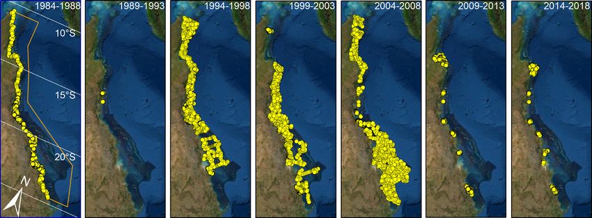
Carter et al.                                                                                Seagrass spatial data for the Great Barrier Reef

ecosystem, seagrass meadows play a critical role as food and           and corrected individual records, including those from two to
shelter for fish and crustaceans caught by recreational, tradi-         three decades ago by drawing on the knowledge of one of our
tional, and commercial fishers (Hayes et al. 2020). They pro-           authors (RC) who led the early seagrass data collection and
vide essential food for dugongs (Dugong dugon) and green sea           mapping programs. We provide this extensive seagrass data
turtles (Chelonia mydas) (Marsh et al. 2011; Kelkar et al. 2013;       set, along with an interactive website, as a tool for the global
Scott et al. 2018).                                                    marine research community to interrogate species distribu-
   A series of intense tropical cyclones with associated high          tions and to benchmark trends through time in this iconic
rainfall and flooding severely reduced seagrass biomass and             World Heritage Area.
extent in parts of the southern two-thirds of the GBRWHA
between 2009 and 2012 (Collier et al. 2012; Rasheed
et al. 2014; Coles et al. 2015; McKenna et al. 2015) and was           Data description
implicated in increased stranding and mortality of marine tur-
                                                                          This data set is a compilation of spatial data from seagrass
tles (Flint et al. 2015, 2017) and dugong (Flint and Lim-
                                                                       surveys in the GBRWHA from 1984 to 2018. Data sets were
pus 2013; Wooldridge 2017). These events focused global
                                                                       collected for five major purposes: (1) an original project that
concern on the resilience of coastal ecosystems to environ-
                                                                       mapped all coastal seagrass to  15 m depth in the 1980s;
mental disturbance, particularly in a warming climate (Coles
                                                                       (2) extensive cross-shelf subtidal surveys in the early to mid-
et al. 2015; Brodie and Pearson 2016; York et al. 2017). Fur-
                                                                       1990s and again in 2003–2005; (3) mapping of intertidal areas
thermore, they highlighted the broad scales over which
                                                                       as part of an oil spill response atlas, commencing in 2001;
seagrass meadows can be impacted, an issue that affects man-
                                                                       (4) smaller and more targeted mapping projects such as for
agement activities and underpins scientific understanding
                                                                       Dugong Protected Area surveys; and (5) a comprehensive
needed for seagrass recovery and to maintain resilience. Gen-
                                                                       series of mapping and monitoring projects for Queensland
erating the necessary data to support this understanding pre-
                                                                       ports that in some cases extend back more than 20 years
sents a challenge for scientists and managers because of the
enormous spatial scale, the remoteness of many coastal habi-
tats (particularly in the Indo-Pacific), and the inherent spatial
and temporal variability.
   Key to addressing these challenges is access to data for
analysis and comparison at appropriate spatial and temporal
scales in a user-friendly format. Such data can be used for
describing the present condition of ecosystems; understand-
ing long-term trends while accounting for short-term impact-
recovery cycles; defining the desired state of the diversity of
habitats; establishing ecologically relevant targets that can be
used to maintain resilience; and implementing appropriate
management frameworks that maintain resilience (Levin and
Möllmann 2015; Hallett et al. 2016; Brodie et al. 2017;
O’Brien et al. 2017; York et al. 2017; Collier et al. 2020). To
this end, there is an increasing use of Geographic Information
Systems (GIS) to record, synthesize, and analyze data and to
benchmark previous states to inform research, conservation,
ecosystem-based management, and marine spatial planning
(St. Martin 2004; St. Martin and Hall-Arber 2008). Within the
GBRWHA, seagrass research extends back to the 1970s (Birch
and Birch 1984) but data collection with a major spatial/map-
ping focus did not commence until the mid-1980s. Mapping
projects since that time range from surveys quantifying sea-
bed benthic cover across the entire GBRWHA funded by a
range of government agencies, to those collected under indus-
try contracts for specific areas and where covenants on their
use and availability may be in force (Table 1).
   In this data article, we compiled several hundred seagrass
data sets collected within the GBRWHA into a standardized              Fig 1. Seagrass presence and absence at sampling sites across the Great
form with site-specific spatial and temporal information                Barrier Reef World Heritage Area (orange boundary). Satellite image
(Fig. 1). We have revisited, evaluated, simplified, standardized,       courtesy: ESRI.

                                                                   3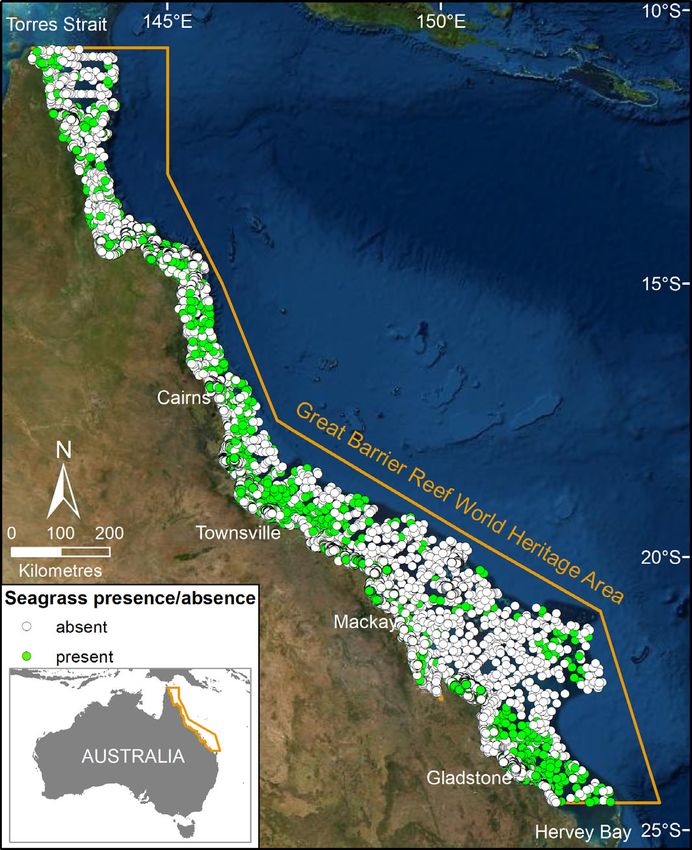
Carter et al. Seagrass spatial data for the Great Barrier Reef
(Table 1). In total, the data set has 81,387 data points that can dominant sediment, survey month and year, survey name,
be viewed interactively through eAtlas or downloaded. and sampling method. Seagrass data are limited to the extent
Mapping data for historic records (1980s) were transcribed of the GBRWHA, with the exception that estuarine seagrass
from original logged and mapped data based on coastal topog- data that extended west into State of Queensland waters is
raphy, dead reckoning fixes, and RADAR estimations included. Seagrass distributions generated from modeled data
(McKenzie et al. 2014a). More recent data (1990s onwards) are are not included in this data set (Coles et al. 2009; Grech and
GPS located. The GPS was left on during each survey to ensure Coles 2010).
maximum accuracy in location fixes (± 5 m). The spatial accu- Data, metadata, and the interactive website are available at
racy of data collected pre-GPS in the 1980s is ± 100 m. A range eAtlas at https://doi.org/10.25909/y1yk-9w85 (Carter
of site descriptions and contextual information is contained et al. 2020). We intend these data to be used as a stand-alone
in original trip reports and publications (Table 1). Details for product or integrated with other publically available biophysi-
each survey site include latitude and longitude, depth in cal data sets and models (e.g., https://ereefs.org.au/ereefs) to
meters below mean sea level (MSL), overall seagrass presence/ explain distributions and change. We include and make avail-
absence, individual seagrass species presence/absence, able data not previously available to the public.
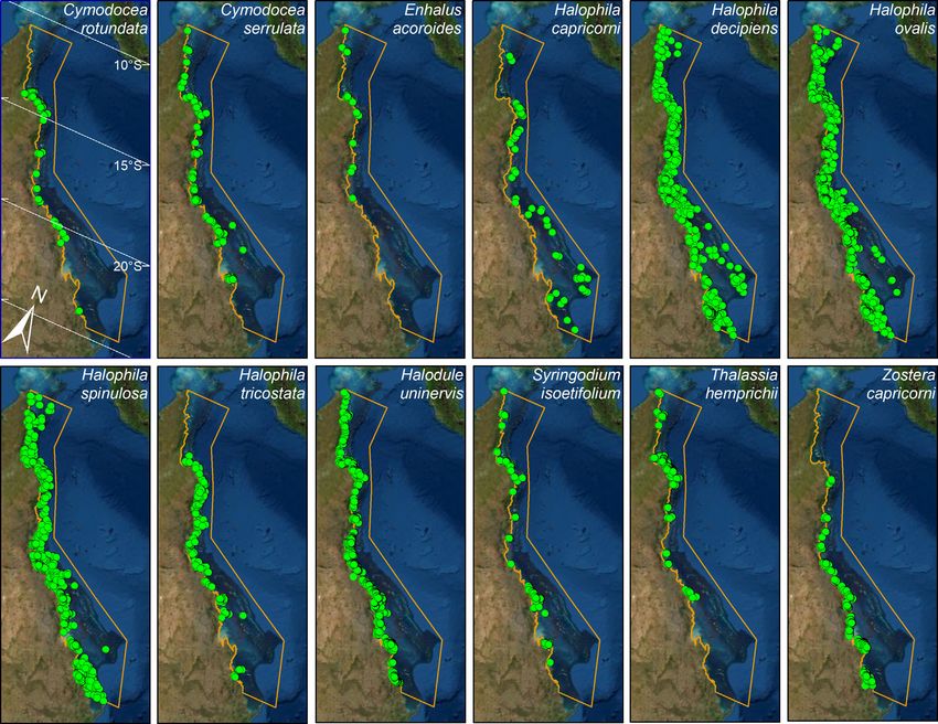
Fig 2. Distribution of 12 seagrass species in our data set (green dots) throughout the Great Barrier Reef World Heritage Area (orange boundary)
observed in the site data synthesis. Sites were surveyed to a depth of 117 m but seagrass presence was not recorded deeper than 76 m. Satellite image
courtesy: ESRI.
4Carter et al. Seagrass spatial data for the Great Barrier Reef Methods 2. Helicopter: As for walking, but seagrass and seagrass species All spatial site data were converted to point shapefiles with presence/absence was recorded from a helicopter in low the same coordinate system (GDA94), then compiled into a hover (
Carter et al.                                                                                   Seagrass spatial data for the Great Barrier Reef

   (Fig. 3g). Seagrass samples were collected during recording             we have updated and standardized the terms used to describe
   of 100 m camera tow (see method, above). Seabed biodiver-               survey methods.
   sity samples were collected between 2003 and 2006 by ben-                   Sediment type in the original data sets were based on grain
   thic sled, trawl net and towed digital cameras (Detailed                size analysis or deck descriptions. For consistency, in this
   methods here: http://www.frdc.com.au/Archived-Reports/                  compilation we include only the most dominant sediment
   FRDC%20Projects/2003-021-DLD.pdf). Data were curated                    type (mud, sand, shell, gravel, rock, rubble), removed descrip-
   to remove outliers and accept only data with a physical                 tors such as “fine,” “very fine,” “coarse,” and so on, and rep-
   and photo record.                                                       laced redundant terms, for example, “mud” and “silt” are
6. Boat—grab: van Veen grab samples (grab area 0.0625 m2)                  termed “mud.”
   were commonly used to confirm seagrass presence/absence                      Depth (m below MSL) for each subtidal site was extracted
   and species identification at subtidal sites where visibility            from the gbr30 data set (Beaman 2017). Depth for intertidal
   was too low for camera sampling or diving, or in combina-               sites was recorded as 0 m MSL.
   tion with camera sampling (Fig. 3h). Between 1 and 3 grab
   samples were taken at each site.
                                                                           Technical validation
Where replicate quadrats, camera frames or grabs were used to                 The original seagrass data come from a variety of surveys
assess a site, a positive recording of seagrass and seagrass spe-          conducted for different purposes and using different methods.
cies in any one replicate was used to characterize the                     Only two projects, GBR Deep-Water and GBR Seabed Biodiver-
overall site. Survey methods were frequently combined at                   sity (Table 1), were sampled in a systematic way across the
sampling sites. For example, boat-based surveys used van                   entire GBRWHA. In the 2009–2018 period, survey coverage is
Veen grabs to confirm species identification where video or                  relatively small as the focus of most surveys shifted from
divers are used; towed sleds generally have a video mounted                large-scale baseline mapping to smaller-scale annual long-term
to also record transects; and boats were used to confirm assess-            monitoring, particularly in ports (Fig. 4). For early data (1980s
ments for sites surveyed by helicopter but where visibility                and 1990s), each data point was reviewed and compared with
was low.                                                                   original trip logs and recollections of trip participants. Since
    The sampling methods to study, describe, and monitor                   the original surveys there have been numerous changes to the
seagrass meadows were implemented by the James Cook Uni-                   shoreline, the most obvious through personal observations
versity (JCU) Seagrass Group (formerly the Marine Ecology                  and satellite imagery being seaward encroachment of man-
Group at Fisheries Queensland prior to 2013) and CSIRO and                 grove forests and reclamations for marina and coastal develop-
tailored to the location and habitat surveyed, and are                     ment. We have not edited our data set to prevent older data
described in detail in the relevant publications for each data             from overlapping newer features.
set are provided in Table 1. For long-term monitoring data                    Users of these data should consider the spatial coverage of
sets, the most recent report is referenced. In this compilation            each site, which varied according to collection method, for

Fig 4. Distribution of sampling sites (yellow dots) throughout the Great Barrier Reef World Heritage Area (orange boundary) in 5-year increments,
1984–2018. Satellite image courtesy: ESRI.

                                                                       6
Carter et al. Seagrass spatial data for the Great Barrier Reef
example, sites sampled by van Veen grab (three replicate grabs key ecological questions including probability modeling
with an area of 0.0625 m2 each) have a relatively lower proba- of seagrass distributions in the GBRHWA’s deep-water lagoon
bility of detecting seagrass compared with helicopter, walking (Coles et al. 2009) and inshore region (Grech and Coles 2010);
and diving surveys where an approximate 10 m2 area was seagrass risk exposure modeling (Grech et al. 2011, 2012);
assessed and presence of seagrasses between individual sam- propagule distribution (Grech et al. 2016); connectivity
pling sites was easily identified to ensure a high confidence in among meadows (Tol et al. 2017; Grech et al. 2018); under-
detection level. Trend analysis is most suitable to locations standing changes in seagrass meadow health using MODIS
where Queensland ports long-term monitoring surveys occur imagery (Petus et al. 2014); and defining the desired state of
at least annually (Table 1): Cairns, Mourilyan Harbor, Towns- seagrass communities in the Townsville region (Lambert
ville, Mackay, Hay Point, Abbot Point, and Gladstone. Outside et al. 2019; Collier et al. 2020). We now make available the
of these locations the temporal resolution of data is limited. data behind these analyses and data updated to 2018 for
Most data (80%) come from the austral growing season the global community to use and compare.
(August–January for most Australian tropical seagrass species).
It is important to understand that data collected in the senes-
cent season (February–July) may record deep-water Halophila References
species as absent as they may only be present as a seed bank Ayling, A. M., A. J. Roelofs, L. J. McKenzie, and W. J. Lee
through the colder months of the year (York et al. 2015; Char- Long. 1997. Port of Cape Flattery benthic monitoring, base-
trand et al. 2018). Seagrasses were recorded at around 40% of line survey: Wet season (February) 1996. Ports Corporation
sites; however, many surveys were targeted at known of Queensland, p. 67.
meadows (e.g., ports long-term monitoring annual surveys of Beaman, R. J. 2017. High-resolution depth model for
designated monitoring meadows), so sites were not always the Great Barrier Reef—30 m. Geoscience Australia, Can-
randomly assigned to include areas unlikely to have seagrass. berra. Available from http://pid.geoscience.gov.au/dataset/
Sites include depths down to 123 m but seagrass was not 115066
recorded below 76 m. Only species of the genus Halophila Birch, W., and M. Birch. 1984. Succession and pattern of trop-
were found in sites below 40 m. ical intertidal seagrasses in Cockle Bay, Queensland,
There is an earlier version of the seagrass site data on eAtlas Australia: A decade of observations. Aquat. Bot. 19: 343–
which includes similar information which is still available 367. doi:10.1016/0304-3770(84)90048-2
(1984–2014; https://eatlas.org.au/nesp-twq-1/gbr-seagrass- Brodie, J., and R. G. Pearson. 2016. Ecosystem health of the
mapping-3-1). Great Barrier Reef: Time for effective management action
based on evidence. Estuar. Coast. Shelf Sci. 183: 438–451.
doi:10.1016/j.ecss.2016.05.008
Data use and recommendations for reuse Brodie, J. E., and others. 2017. Setting ecologically relevant
Worldwide, the management and conservation of marine targets for river pollutant loads to meet marine water qual-
ecosystems require accurate spatial data at a scale that ity requirements for the Great Barrier Reef, Australia: A pre-
matches human activities and impacts (Hughes et al. 2005; liminary methodology and analysis. Ocean Coast. Manag.
Halpern et al. 2008; Visconti et al. 2013; Lagabrielle 143: 136–147. doi:10.1016/j.ocecoaman.2016.09.028
et al. 2018). The synthesis of large spatial data sets provides a Bryant, C., J. Wells, and M. Rasheed. 2019. Port of Townsville
valuable tool that can be used to inform marine spatial plan- annual Seagrass monitoring survey: October 2018. Centre
ning, ecosystem-based management, research, and education for Tropical Water & Aquatic Ecosystem Research
(Halpern et al. 2008). A key strategy to assist this is to ensure (TropWATER) Publication 19/01, James Cook Univ., p. 47.
we validate and share data that have been collected over the Available from https://www.dropbox.com/s/71tmm64c1yo
years (Rajabifard et al. 2005). This project makes publicly rfjl/19%2001%20Port%20of%20Townsville%20annual%20
available one of the world’s most comprehensive seagrass data seagrass%20monitoring.pdf?dl=0
sets. Importantly, we include site data from previously Campbell, S. J., C. A. Roder, L. J. McKenzie, and W. J. Lee
unreleased industry-funded surveys. Also important for users Long. 2002. Seagrass resources in the Whitsunday region,
of these data is we include location information not just for 1999 and 2000. DPI Information Series QI02043, Northern
sites that were surveyed and seagrass recorded, but also loca- Fisheries Centre, p. 50. Available from https://www.
tion information where seagrass was absent. seagrasswatch.org/wp-content/uploads/Resources/Pub
Spatial data are an increasingly important tool in the lications/Misc/Report/EastCoast-GBR/Whitsundays_Seagrass
assessment and management of the marine environment _Survey_Final.pdf
(Hughes et al. 2005; Rajabifard et al. 2005; St. Martin and Carter, A. B., K. M. Chartrand, and M. A. Rasheed. 2012.
Hall-Arber 2008). The immediate scientific value of this pro- Critical marine habitats in high risk areas, Princess Char-
ject and its approach already have been widely demonstrated, lotte Bay region—2011 atlas. Northern Fisheries Cen-
with earlier subsets of this synthesis used to answer a range of tre, p. 67.
7Carter et al. Seagrass spatial data for the Great Barrier Reef
Carter, A., H. Taylor, S. McKenna, and M. Rasheed. 2013. Crit- Coles, R. G., W. J. Lee Long, L. J. McKenzie, and C. A. Roder.
ical marine habitats in high risk areas, Torres Strait—Seo 2002. Seagrass and the marine resources in the dugong pro-
Reef to Kai-Wareg Reef. James Cook Univ., p. 67. tection areas of Upstart Bay, Newry region, Sand Bay, Ince
Carter, A., and M. Rasheed. 2019. Mackay-Whitsunday Bay and the Clairview region. April/May 1999 and October
Seagrass monitoring 2018: Marine inshore south zone. 1999 Great Barrier Reef Marine Park Authority, p. 131.
Centre for Tropical Water & Aquatic Ecosystem Research Available from https://elibrary.gbrmpa.gov.au/jspui/
Publication 19/05. James Cook Univ., p. 16. handle/11017/353
Carter, A. B., and M. A. Rasheed. 2014. Critical marine habi- Coles, R. G., and others. 2007. Status and trends of Seagrass
tats in high risk areas, South Warden Reef to Howick habitats in the Great Barrier Reef World Heritage Area. Reef
Group—2013 atlas. James Cook Univ., p. 62. and Rainforest Research Centre Limited, p. 122. Available
Carter, A. B., and M. A. Rasheed. 2015. Critical marine habi- from https://www.seagrasswatch.org/wp-content/uploads/
tats in high risk areas, Crescent Reef to Cape Flattery— Resources/Publications/2007/PDF/113_QDPI_Coles_et_al_
2014 atlas. James Cook Univ., p. 48. 2007_Status_and_Trends.pdf
Carter, A. B., S. A. McKenna, M. A. Rasheed, C. Collier, L. Coles, R. G., M. A. Rasheed, L. J. McKenzie, A. Grech, P. H.
McKenzie, R. Pitcher, and R. Coles. 2020. Seagrass mapping York, M. Sheaves, S. McKenna, and C. Bryant. 2015. The
synthesis: A resource for coastal management in the Great Great Barrier Reef World Heritage Area seagrasses: Manag-
Barrier Reef. NESP TWQ project 3.2.1 and 5.4, Centre for ing this iconic Australian ecosystem resource for the future.
Tropical Water & Aquatic Ecosystem Research Estuar. Coast. Shelf Sci. 153: A1–A12. doi:10.1016/j.ecss.
(TropWATER), James Cook Univ. doi:10.25909/y1yk-9w85 2014.07.020
Chartrand, K., J. Wells, A. Carter, and M. Rasheed. 2019. Collier, C. J., M. Waycott, and L. J. McKenzie. 2012. Light
Seagrasses in Port Curtis and Rodds Bay 2018: Annual long- thresholds derived from seagrass loss in the coastal zone
term monitoring. James Cook Univ., p. 71. of the northern Great Barrier Reef, Australia. Ecol. Indic.
Chartrand, K. M., M. Szabo , S. Sinutok, M. A. Rasheed, and 23: 211–219. doi:10.1016/j.ecolind.2012.04.005
P. J. Ralph. 2018. Living at the margins: The response of Collier, C. J., and others. 2020. An evidence-based approach
deep-water seagrasses to light and temperature renders for setting desired state in a complex Great Barrier Reef
them susceptible to acute impacts. Mar. Environ. Res. 136: seagrass ecosystem: A case study from Cleveland Bay. Envi-
126–138. doi:10.1016/j.marenvres.2018.02.006 ron. Sustain. Indicat. 7: 100042. doi:10.1016/j.indic.2020.
Coles, R., L. McKenzie, G. De’ath, A. Roelofs, and W. L. Long. 100042
2009. Spatial distribution of deepwater seagrass in the Flint, J., and C. J. Limpus. 2013. Marine wildlife stranding and
inter-reef lagoon of the Great Barrier Reef World Heritage mortality database annual report 2012. I. Dugong. Conser-
Area. Mar. Ecol. Prog. Ser. 392: 57–68. vation Technical and Data Report 2012(1), Department of
Coles, R. G., W. J. Lee Long, and L. C. Squire. 1985. Seagrass Environment and Heritage Protection, Queensland Govern-
beds and prawn nursery grounds between Cape York and ment, p. 42. Available from file:///C:/Users/jc135565/App
Cairns. Information series Q185017, Queensland Depart- Data/Local/Temp/dugong-annual-stranding-report-2012.pdf
ment of Primary Industries. Available from https:// Flint, J., M. Flint, C. J. Limpus, and P. C. Mills. 2015. Trends in
catalogue.nla.gov.au/Record/1795795 marine turtle strandings along the East Queensland, Australia
Coles, R. G. 1987. Seagrass beds and juvenile prawn nursery coast, between 1996 and 2013. J. Mar. Biol. 2015: 1–7. doi:
grounds between Bowen and Water Park Point: A report to 10.1155/2015/848923
the Great Barrier Reef Marine Park Authority. Information Flint, J., M. Flint, C. J. Limpus, and P. C. Mills. 2017. The
series QI87021, Queensland Department of Primary Indus- impact of environmental factors on marine turtle stranding
tries, p. 43. Available from https://catalogue.nla.gov.au/ rates. PLoS One 12: e0182548. doi:10.1371/journal.pone.
Record/4282180 0182548
Coles, R. G., W. J. Lee Long, K. J. Miller, K. P. Vidler, and K. D. Fourqurean, J. W., and others. 2012. Seagrass ecosystems as a
Derbyshire. 1990. Seagrass beds and juvenile prawn and globally significant carbon stock. Nat. Geosci. 5: 505–509.
fish nursery grounds between Water Park Point and Hervey doi:10.1038/ngeo1477
Bay, Queensland. Information series QI92011, Queensland Grech, A., and R. G. Coles. 2010. An ecosystem-scale predic-
Department of Primary Industries. tive model of coastal seagrass distribution. Aquat. Conserv.
Coles, R. G., W. J. Lee Long, S. A. Helmke, R. E. Bennett, K. J. Mar. Freshwat. Ecosyst. 20: 437–444. doi:10.1002/aqc.1107
Miller, and K. J. Derbyshire. 1992. Seagrass beds and juve- Grech, A., R. Coles, and H. Marsh. 2011. A broad-scale assess-
nile prawn and fish nursery grounds: Cairns to Bowen, ment of the risk to coastal seagrasses from cumulative
Queensland. Information series QI92012, Queensland threats. Mar. Policy 35: 560–567. doi:10.1016/j.marpol.
Department of Primary Industries, p. 64. 2011.03.003
8Carter et al. Seagrass spatial data for the Great Barrier Reef
Grech, A., K. Chartrand-Miller, P. Erftemeijer, M. Fonseca, L. Lee Long, W. J., L. J. McKenzie, and R. G. Coles. 1996a. Distri-
McKenzie, M. Rasheed, H. Taylor, and R. Coles. 2012. A bution of Seagrasses in Shoalwater Bay, Queensland—Sep-
comparison of threats, vulnerabilities and management tember 1995. Northern Fisheries Centre.
approaches in global seagrass bioregions. Environ. Res. Lett. Lee Long, W. J., M. A. Rasheed, L. J. McKenzie, and R. G. Coles.
7: 024006. 1996b. Distribution of Seagrasses in Cairns Harbour and Trin-
Grech, A., J. Wolter, R. Coles, L. McKenzie, M. Rasheed, C. D. ity Inlet—December 1993. Northern Fisheries Centre, p. 14.
Thomas, M. Waycott, and E. Hanert. 2016. Spatial patterns Lee Long, W. J., A. J. Roelofs, R. G. Coles, and L. J. McKenzie.
of seagrass dispersal and settlement. Divers. Distribut. 22: 2002. In Monitoring Oyster Point Seagrasses—1995 to
1150–1162. doi:10.1111/ddi.12479 1999. Publication no. 71, Great Barrier Reef Marine Park
Grech, A., and others. 2018. Predicting the cumulative effect Authority. Available from file:///C:/Users/jc135565/App
of multiple disturbances on seagrass connectivity. Glob. Data/Local/Temp/Monitoring-Oyster-Point-seagrasses-1995-
Chang. Biol. 24: 3093–3104. doi:10.1111/gcb.14127 to-1999.pdf
Hallett, C. S., and others. 2016. A review of Australian Levin, P. S., and C. Möllmann. 2015. Marine ecosystem regime
approaches for monitoring, assessing and reporting estua- shifts: Challenges and opportunities for ecosystem-based man-
rine condition: II State and territory programs. Environ. agement. Philos. Trans. Roy. Soc. B Biol. Sci. 370: 20130275.
Sci. Pol. 66: 270–281. doi:10.1016/j.envsci.2016.07.013 doi:10.1098/rstb.2013.0275
Halpern, B. S., and others. 2008. A global map of human Marsh, H., T. J. O’Shea, and J. E. Reynolds III. 2011. Ecology
impact on marine ecosystems. Science 319: 948–952. doi: and conservation of the Sirenia: Dugongs and manatees.
10.1126/science.1149345 Cambridge Univ. Press.
Hayes, M. A., E. C. McClure, P. H. York, K. I. Jinks, M. A. McKenna, S., M. Rasheed, C. Reason, J. Wells, and L.
Rasheed, M. Sheaves, and R. M. Connolly. 2020. The differ- Hoffman. 2019. Port of Abbot Point long-term seagrass
ential importance of deep and shallow seagrass to nekton monitoring program—2018. James Cook Univ.
assemblages of the Great Barrier Reef. Diversity 12: 292. McKenna, S. A., J. C. Jarvis, T. Sankey, C. Reason, R. Coles,
doi:10.3390/d12080292 and M. A. Rasheed. 2015. Declines of seagrasses in a tropi-
Hughes, T. P., D. R. Bellwood, C. Folke, R. S. Steneck, and J. cal harbour, North Queensland, Australia, are not the result
Wilson. 2005. New paradigms for supporting the resilience of a single event. J. Biosci. 40: 389–398. doi:10.1007/
of marine ecosystems. Trends Ecol. Evol. 20: 380–386. doi: s12038-015-9516-6
10.1016/j.tree.2005.03.022 McKenzie, L. J., and W. J. Lee Long. 1996. Distribution and
Kelkar, N., R. Arthur, N. Marba, and T. Alcoverro. 2013. Green abundance of Green Island seagrass meadows. CRC Reef
turtle herbivory dominates the fate of seagrass primary pro- Research Technical Report, CRC Reef Research Centre.
duction in the Lakshadweep islands (Indian Ocean). Mar. McKenzie, L. J., W. J. Lee Long, and E. J. Bradshaw. 1997. Dis-
Ecol. Prog. Ser. 485: 235–243. doi:10.1007/s00227-019- tribution of seagrasses in the Lizard Island group—A recon-
3584-3 naissance survey, October 1995. CRC Reef Research Centre
Kenworthy, W. J., S. Wyllie-Echeverria, R. G. Coles, G. Technical Report No. 14 CRC Reef Research Centre. Avail-
Pergent, and C. Pergent-Martini. 2006. Seagrass conserva- able from https://www.seagrasswatch.org/wp-content/up
tion biology: An interdisciplinary science for protection of loads/Resources/Publications/Misc/Report/EastCoast-GBR/
the seagrass biome, p. 595–623. In A. W. D. Larkum, R. J. McKenzie_et_al_1997.pdf
Orth, and C. M. Duarte [eds.], Seagrasses: Biology, ecology McKenzie, L. J., R. L. Yoshida, A. Grech, and R. G. Coles.
and conservation. Springer. 2014a. Composite of coastal seagrass meadows in Queens-
Lagabrielle, E., A. T. Lombard, J. M. Harris, and T.-C. land, Australia–November 1984 to June 2010. doi:10.1594/
Livingstone. 2018. Multi-scale multi-level marine spatial PANGAEA.826368
planning: A novel methodological approach applied in McKenzie, L. J., R. L. Yoshida, and R. K. F. Unsworth. 2014b.
South Africa. PLoS One 13: e0192582. doi:10.1371/journal. Disturbance influences the invasion of a seagrass into an
pone.0192582 existing meadow. Mar. Pollut. Bull. 86: 186–196. doi:10.
Lambert, V. M., and others. 2019. Towards ecologically rele- 1016/j.marpolbul.2014.07.019
vant targets: Impact of flow and sediment discharge on McKenzie, L. J., C. A. Roder, and R. L. Yoshida. PANGAEA;
seagrass communities in the Great Barrier Reef. 23rd Inter- 2016. Seagrass and associated benthic community data
national Congress on Modelling and Simulation, Canberra, derived from field surveys at Low Isles, Great Barrier Reef,
ACT, Australia. conducted July–August, 1997. doi:10.1594/PANGAEA.
Mateo, O. Serrano, and M. Rozaimi. 2013.
Lavery, P. S., M.-A. 858945
Variability in the carbon storage of seagrass habitats and its O’Brien, K. R., and others. 2017. Seagrass ecosystem trajectory
implications for global estimates of blue carbon ecosystem depends on the relative timescales of resistance, recovery
service. PLoS One 8: e73748. doi:10.1371/journal.pone. and disturbance. Mar. Pollut. Bull. 134: 166–176. doi:10.
0073748 1016/j.marpolbul.2017.09.006
9Carter et al. Seagrass spatial data for the Great Barrier Reef
Pendleton, L., and others. 2012. Estimating global “blue car- St. Martin, K. 2004. GIS in marine fisheries science and
bon” emissions from conversion and degradation of vege- decision-making, p. 237–258. In W. L. Fisher and F. J. Rahel
tated coastal ecosystems. PLoS One 7: e43542. doi:10.1371/ [eds.], Geographic information systems in fisheries. Ameri-
journal.pone.0043542 can Fisheries Society.
Petus, C., C. Collier, M. Devlin, M. Rasheed, and S. McKenna. St. Martin, K., and M. Hall-Arber. 2008. The missing layer:
2014. Using MODIS data for understanding changes in Geo-technologies, communities, and implications for
seagrass meadow health: A case study in the Great Barrier marine spatial planning. Mar. Policy 32: 779–786. doi:10.
Reef (Australia). Mar. Environ. Res. 98: 68–85. doi:10.1016/ 1016/j.marpol.2008.03.015
j.marenvres.2014.03.006 Taylor, H. A., S. A. McKenna, and M. A. Rasheed. 2010. Bus-
Pitcher, C. R., and others. 2007. Seabed biodiversity on the con- tard Bay seagrass baseline assessment: November 2009.
tinental shelf of the Great Barrier Reef World Heritage Area. DEEDI Publication, Fisheries Queensland. Available from
AIMS/CSIRO/QM/QDPI CRC Reef Research Task Final Report. https://www.seagrasswatch.org/wp-content/uploads/Resourc
CRC Reef Research Centre. Available from http://www. es/Publications/Misc/Report/EastCoast-GBR/Taylor_et_al_
frdc.com.au/Archived-Reports/FRDC%20Projects/2003-021- 2010.pdf
DLD.pdf Tol, S. J., J. C. Jarvis, P. H. York, A. Grech, B. C. Congdon, and
Rajabifard, A., A. Binns, and I. Williamson. 2005. Administering R. G. Coles. 2017. Long distance biotic dispersal of tropical
the marine environment—The spatial dimension. J. Spat. Sci. seagrass seeds by marine mega-herbivores. Sci. Rep. 7: 4458.
50: 69–78. doi:10.1080/14498596.2005.9635050 doi:10.1038/s41598-017-04421-1
Rasheed, M., and A. Roelofs. 1996. Distribution and abun- Visconti, P., M. Di Marco, J. Alvarez-Romero, S.
dance of Ellie Point seagrasses—December 1996. Januchowski-Hartley, R. Pressey, R. Weeks, and C.
Unpublished report to the Trinity Inlet Management Pro- Rondinini. 2013. Effects of errors and gaps in spatial data
gram. Queensland Department of Primary Industries. sets on assessment of conservation progress. Conserv.
Rasheed, M. A., C. A. Roder, and R. Thomas. 2001. Port of Biol. 27: 1000–1010. doi:10.1111/cobi.12095
Mackay seagrass, macro-algae and macro-invertebrate com- Wells, J., C. Reason, and M. Rasheed. 2019. Seagrass habitat of
munities, February 2001. CRC Reef Research Centre. Mourilyan Harbour: Annual monitoring report—2018.
Rasheed, M. A., R. Thomas, A. J. Roelofs, and S. A. McKenna. James Cook Univ., Available from https://www.dropbox.
2005. Critical marine habitats adjacent to the high risk com/s/exwwvafteij0nap/19%2014%20Seagrass%20habitat
inner shipping route in the Shelburne, Margaret and %20of%20Mourilyan%20Harbour.pdf?dl=0
Indian Bays region, Far North Queensland, Australia—2005 Wooldridge, S. A. 2017. Preventable fine sediment export
atlas. Northern Fisheries Centre from the Burdekin River catchment reduces coastal seagrass
Rasheed, M. A., T. Nguyen, H. A. Taylor, and R. Thomas. abundance and increases dugong mortality within the
2006. Critical marine habitats adjacent to Hydrographers Townsville region of the Great Barrier Reef, Australia. Mar.
Passage, Great Barrier Reef, Queensland, Australia—2006 Pollut. Bull. 114: 671–678. doi:10.1016/j.marpolbul.2016.
atlas. Northern Fisheries Centre. 10.053
Rasheed, M. A., S. A. McKenna, A. B. Carter, and R. G. Coles. York, P., A. Carter, K. Chartrand, T. Sankey, L. Wells, and
2014. Contrasting recovery of shallow and deep water seagrass M. Rasheed. 2015. Dynamics of a deep-water seagrass
communities following climate associated losses in tropical population on the Great Barrier Reef: Annual occurrence
North Queensland, Australia. Mar. Pollut. Bull. 83: 491–499. and response to a major dredging program. Sci. Rep. 5:
Rasheed, M. A., C. L. Reason, and J. N. Wells. 2019. Seagrass 13167. doi:10.1038/srep13167
habitat of Cairns Harbour and Trinity Inlet: Annual moni- York, P., and M. Rasheed. 2019. Annual seagrass monitoring in
toring report 2018. James Cook Univ., Available from the Mackay–Hay Point region—2018. James Cook Univ.,
https://www.dropbox.com/s/13dqs07ukt8kcri/19%2013% Available from https://www.dropbox.com/s/izeijx26gdzxbq8/
20Seagrass%20Habitat%20of%20Cairns%20Harbour% 19%2018%20Annual%20seagrass%20monitoring%20in%20t
20and%20Trinity%20Inlet%20.pdf?dl=0 he%20Mackay-Hay%20Point%20region%20-%202018.pdf?
Roder, C. A., W. J. Lee Long, L. J. McKenzie, and A. J. Roelofs. dl=0
1998. Proposed Clump Point boat ramp and facilities— York, P. H., and others. 2017. Identifying knowledge gaps in
Review of marine environment factors (Seagrasses and seagrass research and management: An Australian perspec-
other benthic habitats). Unpublished report to Queensland tive. Mar. Environ. Res. 127: 163–172. doi:10.1016/j.
Department of Main Roads. Northern Fisheries Centre. marenvres.2016.06.006
Scott, A. L., and others. 2018. The role of herbivory in struc- York, P. H., P. I. Macreadie, and M. A. Rasheed. 2018. Blue car-
turing tropical seagrass ecosystem service delivery. Front. bon stocks of Great Barrier Reef deep-water seagrasses. Biol.
Plant Sci. 9: 1–10. doi:10.3389/fpls.2018.00127 Lett. 14: 20180529. doi:10.1098/rsbl.2018.0529
10Carter et al. Seagrass spatial data for the Great Barrier Reef
Acknowledgments National Environmental Science Programme (NESP) Tropical Water
Many past and present Queensland Government (Fisheries) and James Quality Hub (Projects 3.1, 3.2.1, and 5.4) in partnership with James
Cook University Centre for Tropical Water and Aquatic Ecosystem Cook University’s Centre for Tropical Water and Aquatic Ecosystem
Research staff have contributed toward data collection and to create Research (TropWATER).
the original spatial layers included in this compilation. We thank the
many groups that provided funding for seagrass surveys included in this
project. These include Ports North, Gladstone Ports Corporation, CSIRO, Conflict of Interest
Maritime Safety Queensland/Department of Transport and Main Roads,
Australian Maritime Safety Authority, North Queensland Bulk Ports, Port The authors declare no conflicts of interest to declare.
of Townsville, Trinity Inlet Management Plan, Trinity Inlet Waterways,
Fisheries Research Development Corporation, CRC Reef Research Centre,
Queensland Department of Agriculture and Fisheries, Great Barrier Reef Submitted 05 November 2020
Marine Park Authority, and the Mackay–Whitsunday–Isaac Healthy Rivers Revised 10 March 2021
to Reef Partnership. MR received support from an Australian Research Accepted 12 April 2021
Council Linkage Grant (LP160100492). This project was funded by the
11You can also read