Bellbird Mineral Resource Drilling and Assaying Completed
←
→
Page content transcription
If your browser does not render page correctly, please read the page content below
www.kglresources.com.au
5/167 Eagle Street St Brisbane, 4000
21st October 2021
Bellbird Mineral Resource Drilling and Assaying Completed
Final assay results for 26 drillholes have been received
25 holes intersected reportable copper mineralisation.
All are part of the resource definition program for the Jervois Project
Some notable intersections1 at Bellbird include:
o KJD449: 3.85m @ 3.74% Cu, 19.9 g/t Ag, 0.58 g/t Au from 80.00m downhole
o KJD450: 5.45m @ 3.62% Cu, 15.8 g/t Ag, 0.15 g/t Au from 59.85m downhole
Including: 2.22m @ 8.08% Cu, 32.6 g/t Ag, 0.30 g/t Au from 65.10m downhole
o KJD455: 4.46m @ 4.68% Cu, 38.3g/t Ag, 0.12 g/t Au from 64.00m downhole,
and
o KJD456: 5.30m @ 3.66% Cu, 29.1g/t Ag, 0.29g.t Au from 128.26m downhole.
Bellbird assays broadly confirm the existing mineral resource model.
Current drilling is focused on finalising Rockface resource definition.
KGL Resources Limited (ASX: KGL) (KGL or the Company) is pleased to report that all final assay results
for the recent resource development drilling program of the Bellbird deposit have been received. Bellbird
forms part of the mineral resource at Jervois, and the drilling program was successfully completed on 16th
August 2021. All Bellbird drill intersections received as a part of this program in 2021 are presented in
Table 2 below.
Like Reward, the Bellbird assays broadly confirm the existing mineral resource model and will result in
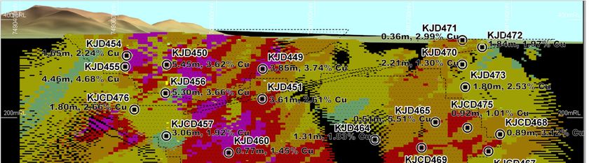
refinements to the geological interpretations. Figure 1 below shows a longitudinal projection of the
Bellbird Main Lode resource block model, with the positions of the relevant intercepts plotted. Note that
the Bellbird deposit contains several hanging wall and footwall lodes which, for clarity, are not shown in
the figure.
Work has commenced on an update to the mineral resource model for Reward and Bellbird. This work is
being done by experienced independent consultants.
Both drill rigs are currently drilling resource development holes at the high-grade Rockface deposit.
KGL Managing Director, Mr. Simon Finnis remarked, “Following on from the Reward resource
development drilling results, this set of consistent intersections from Bellbird is very encouraging,
especially the excellent copper grades from the open-pit resource area. The Company has engaged
1
All intersections reported are estimated true thicknesses.
Page 1 of 10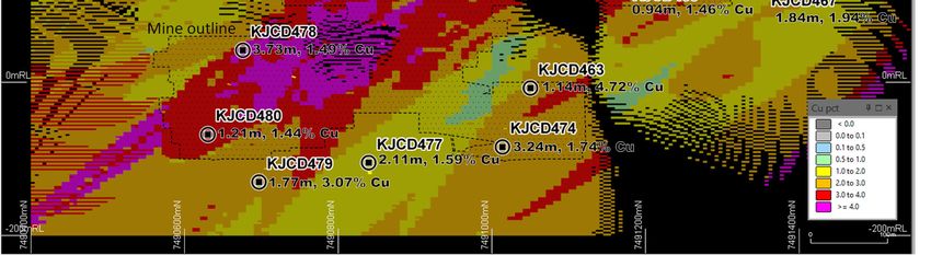
www.kglresources.com.au

skilled and reputable geological consultants, Mining Associates Pty Ltd to undertake a revision of the
Reward and Bellbird mineral resource estimate. This work is already underway and will take
approximately 6 weeks to complete.

“In the meantime, our two diamond drill rigs are busy at Rockface, each operating at either end of the
deposit, to better define the strike and depth extent. Rockface, and indeed the other deposits, are open
at depth, however it is the Company’s intention to cost-effectively explore the very deep potential at
Jervois, by drilling from underground once the mine is in operation.

“The downhole electromagnetics survey (DHEM) was nearing end of the scheduled survey but has been
extended to enable DHEM follow up of the high-grade intersection at Rockface, and of other recent
exploratory holes.”

Figure 1 Longitudinal projection of the Bellbird Deposit Main Lode mineral resource block model (blocks coloured according to
copper grade), showing the drill intersections associated with the Main Lode. Further details of the intersections are in Table 2.
An outline of the most PFS mine design is shown for reference.

www.kglresources.com.au

                                                  Downhole        Est. True
                Depth_From        Depth_To                                             Cu              Ag              Au
  Hole_ID                                         Thickness       Thickness
                    m                m                                                 %               g/t             g/t
                                                      m               m
KJD449                  80.00            84.40             4.40      3.85                   3.74             19.9         0.58
KJD450                  16.00            20.00             4.00      2.06                   0.75              3.3         0.08
                        59.85            68.70             8.85      5.45                   3.62             15.8         0.15
including               65.10            68.70             3.60      2.22                   8.08             32.6         0.30
KJD451                  86.75            89.00             2.25      1.19                   0.71              7.1         0.03
KJD451                 125.00           131.00             6.00      3.61                   2.61             23.0         0.14
KJD454                  25.60            27.60             2.00      1.80                   1.20              5.4         0.08
                        30.60            32.60             2.00      1.80                   0.97              2.3         0.05
                        49.00            50.00             1.00      0.87                   1.08             10.4         0.22
                        53.10            55.00             1.90      1.65                   2.24              2.3         0.05
KJD455                  45.00            51.11             6.11      3.93                   2.04              5.8         0.10
                        64.00            70.00             6.00      4.46                   4.68             38.3         0.12
                        74.00            75.28             1.28      0.95                   6.59             70.3         0.25
                        79.60            83.00             3.40      2.53                   2.91             14.0         0.08
KJD456                 101.75           111.00             9.25      6.87                   1.19              3.8         0.06
                       118.68           119.66             0.98      0.80                   2.59             10.6         0.17
                       128.26           134.73             6.47      5.30                   3.66             29.1         0.29
                       140.00           143.00             3.00      2.46                   1.89             11.5         0.04
KJCD457                202.70           205.70             3.00      2.26                   1.53              7.0         0.13
                       214.50           217.70             3.20      2.45                   2.02              3.6         0.05
                       221.40           222.40             1.00      0.77                   1.11              1.3         0.05
                       225.40           228.40             3.00      2.30                   1.82              6.6         0.06
                       234.40           238.40             4.00      3.06                   1.92              4.3         0.04
KJD460                   4.92             7.93             3.01      *ND                    0.50              5.3         0.00
                        93.67            94.44             0.77      *ND                    1.71              3.6         0.01
                       199.00           200.00             1.00      0.73                   1.36              3.2         0.02
                       260.90           262.10             1.20      0.77                   1.45             12.0         0.04
                       264.50           265.70             1.20      0.77                   1.16             21.5         0.06
KJCD463                401.25           402.85             1.60      1.14                   4.72             21.2         0.31
                       404.69           405.80             1.11      0.79                   1.12             28.8         0.06
                       408.00           410.00             2.00      1.43                   1.77             88.8         0.09
                       412.00           413.17             1.17      0.84                   1.01             12.6         0.04
KJD464                 215.80           216.59             0.79      0.51                   1.80              8.3         0.08
                       227.00           229.03             2.03      1.31                   1.83              8.8         0.12
KJD465                  82.84            83.88             1.04      0.72                   4.56             71.7
www.kglresources.com.au
Downhole Est. True
Depth_From Depth_To Cu Ag Au
Hole_ID Thickness Thickness
m m % g/t g/t
m m
KJCD467 245.48 248.12 2.64 1.84 1.94 28.8 0.16
KJCD468 146.00 147.00 1.00 0.70 0.59 1.7 0.01
207.15 208.42 1.27 0.89 3.12 35.4 0.63
KJCD469 146.00 148.00 2.00 1.49 0.76 6.9 0.01
152.00 153.00 1.00 0.75 0.59 4.2 0.01
163.00 164.00 1.00 0.75 0.76 4.6 0.01
251.10 252.30 1.20 0.94 1.46 7.9 0.10
KJD470 53.43 54.40 0.97 0.75 0.55 3.6 0.03
55.50 56.49 0.99 0.76 0.63 4.6 0.06
58.35 61.21 2.86 2.21 1.30 7.3 0.17
KJD471 1.40 2.60 1.20 0.97 1.10 4.2 0.22
10.15 10.60 0.45 0.36 2.99 10.1 0.12
20.60 21.25 0.65 0.52 0.53 2.1 0.02
KJD472 16.55 19.14 2.59 1.84 1.97 12.8 0.48
22.84 24.14 1.30 0.92 1.07 7.0 0.08
26.00 27.00 1.00 0.71 1.07 4.8 0.11
KJD473 115.16 117.30 2.14 1.80 2.53 12.4 0.26
120.28 120.94 0.66 0.56 0.52 9.1 0.10
KJCD474 469.00 469.70 0.70 0.54 1.55 49.8www.kglresources.com.au
This announcement has been authorised by the KGL Board of Directors.
Competent Persons Statements
The information in this announcement that relates to Exploration Targets and Exploration Results is
based on data compiled by John Levings BSc, a Competent Person who is a Fellow of The Australasian
Institute of Mining and Metallurgy. Mr Levings is Principal Geologist for the Company. Mr Levings has
sufficient experience, which is relevant to the style of mineralisation and type of deposit under
consideration and to the activity, which is being undertaking to qualify as a Competent Person as defined
in the 2012 Edition of ‘Australasian Code for Reporting of Exploration Results, Mineral Resources and
Ore Reserves’. Mr Levings consents to the inclusion in the announcement of the matters based on his
information in the form and context in which it appears.
1 JORC Code, 2012 Edition – Table 1
1.1 Section 1 Sampling Techniques and Data
(Criteria in this section apply to all succeeding sections.)
Criteria JORC Code explanation Commentary
Sampling Nature and quality of sampling (e.g. cut channels, random At Jervois, diamond drilling and reverse
techniques chips, or specific specialised industry standard measurement circulation (RC) drilling were used to obtain
tools appropriate to the minerals under investigation, such as samples for geological logging and
down hole gamma sondes, or handheld XRF instruments, assaying. The core samples comprised a
etc). These examples should not be taken as limiting the mixture of sawn HQ quarter core, sawn NQ
broad meaning of sampling. half core and possibly BQ half core
Include reference to measures taken to ensure sample (historical drilling only). Sample lengths are
representivity and the appropriate calibration of any generally 1m, but at times length were
measurement tools or systems used. adjusted to take into account geological
Aspects of the determination of mineralisation that are variations. RC sample intervals are
Material to the Public Report. predominantly 1m intervals with some 2
In cases where ‘industry standard’ work has been done this and 4m compositing (historical holes only)..
would be relatively simple (e.g. ‘reverse circulation drilling RC samples are routinely scanned by KGL
was used to obtain 1 m samples from which 3 kg was Resources with a Niton XRF. Samples
pulverised to produce a 30 g charge for fire assay’). In other assaying greater than 0.1% Cu, Pb or Zn
cases more explanation may be required, such as where are submitted for analysis at a commercial
there is coarse gold that has inherent sampling problems. laboratory.
Unusual commodities or mineralisation types (e.g. submarine Mineralisation at all deposits is
nodules) may warrant disclosure of detailed information. characterized by disseminations, veinlets
and large masses of chalcopyrite,
associated with magnetite-rich alteration
within a psammite. The mineralisation has
textures indicative of structural
emplacement within specific strata i.e. the
mineral appears stratabound.
Documentation of the historical drilling
(pre-2011) for Reward is variable.
Drilling Drill type (e.g. core, reverse circulation, open-hole hammer, The KGL and previous Jinka-Minerals RC
techniques rotary air blast, auger, Bangka, sonic, etc) and details (e.g. drilling was conducted using a reverse
core diameter, triple or standard tube, depth of diamond tails, circulation rig with a 5.25-inch face-
face-sampling bit or other type, whether core is oriented and sampling bit. Diamond drilling was either
if so, by what method, etc). in NQ2 or HQ3 drill diameters.
Metallurgical diamond drilling (JMET holes)
were PQ
There is no documentation for the historic
drilling techniques.www.kglresources.com.au
Criteria JORC Code explanation Commentary
Diamond drilling was generally cored from
surface with some of the deeper holes at
Rockface and Reward utilizing RC pre-
collars.
Oriented core has been measured for the
recent KGL drilling.
Drill sample Method of recording and assessing core and chip sample The KGL RC samples were not weighed
recovery recoveries and results assessed. on a regular basis but when completed no
Measures taken to maximise sample recovery and ensure sample recovery issues were encountered
representative nature of the samples. during the drilling program.
Whether a relationship exists between sample recovery and Jinka Minerals and KGL split the rare
grade and whether sample bias may have occurred due to overweight samples (>3kg) for assay.
preferential loss/gain of fine/coarse material. Since overweight samples were rarely
reported no sample bias was established
between sample recovery and grade.
Core recovery for recent drilling is >95%
with the mineral zones having virtually
100% recovery.
No evidence has been found for any
relationship between sample recovery and
copper grade and there are no biases in
the sampling with respect to copper grade
and recovery.
Logging Whether core and chip samples have been geologically and All KGL RC and diamond core samples
geotechnically logged to a level of detail to support are geologically logged. Logging in
appropriate Mineral Resource estimation, mining studies and conjunction with multi-element assays is
metallurgical studies. appropriate for mineral resource
Whether logging is qualitative or quantitative in nature. Core estimation.
(or costean, channel, etc) photography. Core samples are also orientated and
The total length and percentage of the relevant intersections logged for geotechnical information.
logged. All logging has been converted to
quantitative and qualitative codes in the
KGL Access database.
All relevant intersections were logged.
Paper logs existed for the historical drilling.
There is very little historical core available
for inspection.
Sub-sampling If core, whether cut or sawn and whether quarter, half or all The following describes the recent KGL
techniques and core taken. sampling and assaying process:
sample If non-core, whether riffled, tube sampled, rotary split, etc and – RC drill holes are sampled at 1m
preparation whether sampled wet or dry. intervals and split using a cone
For all sample types, the nature, quality and appropriateness splitter attached to the cyclone to
generate a split of ~3kg;
of the sample preparation technique.
– RC sample splits (~3kg) are
Quality control procedures adopted for all sub-sampling pulverized to 85% passing 75
stages to maximise representivity of samples. microns.
Measures taken to ensure that the sampling is representative – Diamond core was quartered with a
of the in-situ material collected, including for instance results diamond saw and generally sampled
at 1m intervals with samples lengths
for field duplicate/second-half sampling.
adjusted at geological contacts;
Whether sample sizes are appropriate to the grain size of the – Diamond core samples are crushed
material being sampled. to 70% passing 2mm and then
pulverized to 85% passing 75
microns.
– Two quarter core field duplicates
were taken for every 20m samples
by Jinka Minerals and KGL
Resources.
– All sampling methods and sample
sizes are deemed appropriate for
mineral resource estimationwww.kglresources.com.au
Criteria JORC Code explanation Commentary
Details for the historical sampling are not
available.
Quality of assay The nature, quality and appropriateness of the assaying and The KGL drilling has QAQC data that
data and laboratory procedures used and whether the technique is includes standards, duplicates and
laboratory tests considered partial or total. laboratory checks. In ore zones standards
For geophysical tools, spectrometers, handheld XRF are added at a ratio of 1:10 and duplicates
instruments, etc, the parameters used in determining the and blanks 1:20.
analysis including instrument make and model, reading times, Base metal samples are assayed using a
calibrations factors applied and their derivation, etc. four-acid digest with an ICP AES finish.
Nature of quality control procedures adopted (e.g. standards, Gold samples are assayed by Aqua Regia
blanks, duplicates, external laboratory checks) and whether with an ICP MS finish. Samples over
acceptable levels of accuracy (i.e. lack of bias) and precision 1ppm Au are re-assayed by Fire Assay
have been established. with an AAS finish.
There are no details of the historic drill
sample assaying or any QAQC.
All assay methods were deemed
appropriate at the time of undertaking.
Verification of The verification of significant intersections by either Data is validated on entry into the MS
sampling and independent or alternative company personnel. Access database, using Database check
assaying The use of twinned holes. queries and Maxwell’s DataShed.
Documentation of primary data, data entry procedures, data Further validation is conducted when data
verification, data storage (physical and electronic) protocols. is imported into Micromine and Leapfrog
Discuss any adjustment to assay data. Geo software
Hole twinning was occasionally conducted
at Reward with mixed results. This may be
due to inaccuracies with historic hole
locations rather than mineral continuity
issues.
For the resource estimation below
detection values were converted to half the
lower detection limit.
Location of data Accuracy and quality of surveys used to locate drill holes For the KGL drilling surface collar surveys
points (collar and down-hole surveys), trenches, mine workings and were picked up using a Trimble DGPS,
other locations used in Mineral Resource estimation. with accuracy to 1 cm or better.
Specification of the grid system used. Downhole surveys were taken during
Quality and adequacy of topographic control. drilling with a Ranger or Reflex survey tool
at 30m intervals
All drilling by Jinka Minerals and KGL is
referenced on the MGA 94 Zone 53 grid.
All downhole magnetic surveys were
converted to MGA 94 grid.
For Reward there are concerns about the
accuracy of some of the historic drillhole
collars. There are virtually no preserved
historic collars for checking.
There is no documentation for the
downhole survey method for the historic
drilling.
Topography was mapped using Trimble
DGPS and LIDAR
Data spacing and Data spacing for reporting of Exploration Results. Drilling at Rockface was on nominal 50m
distribution Whether the data spacing and distribution is sufficient to centres with downhole sampling on 1m
establish the degree of geological and grade continuity intervals.
appropriate for the Mineral Resource and Ore Reserve Drilling at Reward was on 25m spaced
estimation procedure(s) and classifications applied. sections in the upper part of the
Whether sample compositing has been applied. mineralisation extending to 50m centres
with depth and ultimately reaching 100m
spacing on the periphery of mineralisation.www.kglresources.com.au
Criteria JORC Code explanation Commentary
For Reward shallow oxide RC drilling was
conducted on 80m spaced traverses with
holes 10m apart.
The drill spacing for all areas is appropriate
for resource estimation and the relevant
classifications applied.
A small amount of sample compositing has
been applied to some of the near surface
historic drilling.
Orientation of Whether the orientation of sampling achieves unbiased Holes were drilled perpendicular to the
data in relation to sampling of possible structures and the extent to which this is strike of the mineralization; the default
geological known, considering the deposit type. angle is -60 degrees, but holes vary from -
structure If the relationship between the drilling orientation and the 45 to -80.
orientation of key mineralised structures is considered to Drilling orientations are considered
have introduced a sampling bias, this should be assessed appropriate and no obvious sampling bias
and reported if material. was detected.
Sample security The measures taken to ensure sample security. Samples were stored in sealed polyweave
bags on site and transported to the
laboratory at regular intervals by KGL staff
or a transport contractor.
Audits or reviews The results of any audits or reviews of sampling techniques The sampling techniques are regularly
and data. reviewed internally and by external
consultants.
1.2 Section 2 Reporting of Exploration Results
(Criteria listed in the preceding section also apply to this section.)
Criteria JORC Code explanation Commentary
Mineral tenement Type, reference name/number, location and ownership The Jervois Project is within EL25429 and
and land tenure including agreements or material issues with third parties EL28082 100% owned by Jinka Minerals
status such as joint ventures, partnerships, overriding royalties, and operated by Kentor Minerals (NT),
native title interests, historical sites, wilderness or national both wholly owned subsidiaries of KGL
park and environmental settings. Resources.
The security of the tenure held at the time of reporting along The Jervois Project is covered by Mineral
with any known impediments to obtaining a licence to operate Claims and an Exploration licence owned
in the area. by KGL Resources subsidiary Jinka
Minerals.
Exploration done Acknowledgment and appraisal of exploration by other Previous exploration has primarily been
by other parties parties. conducted by Reward Minerals, MIM and
Plenty River.
Geology Deposit type, geological setting and style of mineralisation. EL25429 and EL28082 lie on the Huckitta
1: 250 000 map sheet (SF 53-11). The
tenement is located mainly within the
Palaeo-Proterozoic Bonya Schist on the
northeastern boundary of the Arunta
Orogenic Domain. The Arunta Orogenic
Domain in the north western part of the
tenement is overlain unconformably by
Neo-Proterozoic sediments of the
Georgina Basin.
The stratabound mineralisation for the
project consists of a series of complex,
narrow, structurally controlled, sub-vertical
sulphide/magnetite-rich deposits hosted by
Proterozoic-aged, amphibolite grade
metamorphosed sediments of the Arunta
Inlier.
Mineralisation is characterised by veinletswww.kglresources.com.au
Criteria JORC Code explanation Commentary
and disseminations of chalcopyrite in
association with magnetite. In the oxide
zone which is vertically limited malachite,
azurite, chalcocite are the main Cu-
minerals.
Massive to semi-massive galena in
association with sphalerite occur locally in
high grade lenses of limited extent with
oxide equivalents including cerussite and
anglesite in the oxide zone. Generally,
these lenses are associated with more
carbonate-rich host rocks occurring at
Green Parrot, Reward and Bellbird North.
Drill hole A summary of all information material to the understanding of Hold ID Easting Northing RL Azimuth Dip Depth m
Information the exploration results including a tabulation of the following KJD449 627322.12 7490897.49 360.38 269.54 ‐49.82 111.5
KJD450 627292.77 7490699.76 366.78 270.34 ‐65.94 93.5
information for all Material drill holes:
KJD451 627323.38 7490897.52 360.21 267.17 ‐76.15 171.6
o easting and northing of the drill hole collar KJD454 627303.97 7490614.49 367.72 273.94 ‐50.26 80.0
o elevation or RL (Reduced Level – elevation above sea KJD455 627305.02 7490614.13 367.66 271.92 ‐72.72 100.0
level in metres) of the drill hole collar KJD456 627352.30 7490697.01 363.32 268.86 ‐62.87 160.7
o dip and azimuth of the hole KJCD457 627427.11 7490697.38 366.59 268.71 ‐64.87 279.4
o down hole length and interception depth KJD460 627420.11 7490843.65 366.33 259.15 ‐70.24 300.6
o hole length. KJCD463 627451.26 7491045.69 357.84 269.11 ‐71.00 430.1
If the exclusion of this information is justified on the basis that KJD464 627362.14 7491120.73 357.75 269.15 ‐65.40 272.2
KJD465 627324.41 7491246.09 355.93 270.51 ‐66.89 230.8
the information is not Material and this exclusion does not
KJCD466 627420.19 7491243.08 355.65 270.28 ‐66.09 342.6
detract from the understanding of the report, the Competent KJCD467 627365.86 7491347.88 354.76 272.05 ‐69.22 279.7
Person should clearly explain why this is the case. KJCD468 627340.94 7491373.79 355.14 270.40 ‐68.00 240.7
KJCD469 627380.64 7491207.05 356.11 269.20 ‐64.91 301.1
KJD470 627240.00 7491300.00 360.00 269.05 ‐60.02 90.0
KJD471 627210.00 7491300.00 360.00 268.67 ‐54.88 30.6
KJD472 627208.03 7491340.13 359.19 270.13 ‐58.99 40.0
KJD473 627293.91 7491307.35 356.07 269.18 ‐56.75 150.6
KJCD474 627530.10 7491025.00 357.18 267.43 ‐70.78 531.1
KJCD475 627378.70 7491303.98 355.35 272.32 ‐58.26 255.7
KJCD476 627414.70 7490631.00 366.20 269.33 ‐59.72 230.9
KJCD477 627598.30 7490866.00 361.62 270.67 ‐70.66 576.7
KJCD478 627679.70 7490792.00 365.15 245.91 ‐57.81 531.6
KJCD479 627656.22 7490812.81 364.51 245.49 ‐74.70 643.3
KJCD480 627740.09 7490734.22 365.94 243.02 ‐72.20 697.0
For intercept depths please see Table 2 in the
body of the report
Data aggregation In reporting Exploration Results, weighting averaging Minimum grade truncation 0.5%Cu for
methods techniques, maximum and/or minimum grade truncations (eg intercepts above 200m RL
cutting of high grades) and cut-off grades are usually Material Minimum grade truncation 1.0%Cu for
and should be stated. intercepts below 200m RL
Where aggregate intercepts incorporate short lengths of high Aggregate intercepts use length-weighting
grade results and longer lengths of low grade results, the No top-cuts are applied nor considered
procedure used for such aggregation should be stated and necessary
some typical examples of such aggregations should be No metal equivalents are used
shown in detail.
The assumptions used for any reporting of metal equivalent
values should be clearly stated.
Relationship These relationships are particularly important in the reporting In the main deposit areas, the geometry of
between of Exploration Results. the lodes is well known and is used to
mineralisation If the geometry of the mineralisation with respect to the drill estimate true widths, which are quoted in
widths and hole angle is known, its nature should be reported. the report
intercept lengths If it is not known and only the down hole lengths are reported,
there should be a clear statement to this effect (eg ‘down hole
length, true width not known’).
Diagrams Appropriate maps and sections (with scales) and tabulations Refer Figures 1 and 2 in the report
of intercepts should be included for any significant discovery
being reported These should include, but not be limited to a
plan view of drill hole collar locations and appropriate
sectional views.
Balanced Where comprehensive reporting of all Exploration Results is Results for all holes are reported according
reporting not practicable, representative reporting of both low and high to the Data Aggregation Methods stated
grades and/or widths should be practiced to avoid misleading above
reporting of Exploration Results.www.kglresources.com.au
Criteria JORC Code explanation Commentary
Other substantive Other exploration data, if meaningful and material, should be Outcrop mapping of exploration targets
exploration data reported including (but not limited to): geological using Real time DGPS.
observations; geophysical survey results; geochemical IP, Magnetics, Gravity, Downhole EM are
survey results; bulk samples – size and method of treatment; all used for targeting
metallurgical test results; bulk density, groundwater, Metallurgical studies are well advanced
geotechnical and rock characteristics; potential deleterious or including recovery of the payable metals
contaminating substances. including Cu, Ag and Au.
Deleterious elements such as Pb Zn Bi and
F are modelled
Further work The nature and scale of planned further work (eg tests for The current report relates to infill and
lateral extensions or depth extensions or large-scale step-out mineral resource confirmatory drilling and
drilling). is ongoing
Diagrams clearly highlighting the areas of possible Brownfields and greenfield drilling has also
extensions, including the main geological interpretations and commenced
future drilling areas, provided this information is not Additional IP and DHEM surveys are
commercially sensitive. plannedYou can also read