Automated system for dispatching the movement of unmanned aerial vehicles with a distributed survey of flight tasks
←
→
Page content transcription
If your browser does not render page correctly, please read the page content below
Journal of Intelligent Systems 2021; 30: 728–738 Research Article Dmitry Gura*, Victor Rukhlinskiy, Valeriy Sharov, and Anatoliy Bogoyavlenskiy Automated system for dispatching the movement of unmanned aerial vehicles with a distributed survey of flight tasks https://doi.org/10.1515/jisys-2021-0026 received February 03, 2021; accepted April 08, 2021 Abstract: Over the past decade, unmanned aerial vehicles (UAVs) have received increasing attention and are being used in the areas of harvesting, videotaping, and the military industry. In this article, the consideration is focused on areas where video recording is required for ground inspections. This paper describes modern communication technologies and systems that enable interaction and data exchange between UAVs and a ground control station (GCS). This article focuses on different architectures of com- munication systems, establishing the characteristics of each to identify the preferred architecture that does not require a significant consumption of resources and whose data transmission is reliable. A coherent architecture that includes multiple UAVs, wireless sensor networks, cellular networks, GCSs, and satellite network to duplicate communications for enhanced system security has been offered. Some reliability problems have been discussed, the solution of which was suggested to be a backup connection via satellite, i.e., a second connection. This study focused not only on the communication channels but also on the data exchanged between system components, indicating the purpose of their application. Some of the commu- nication problems and shortcomings of various systems, as well as further focus areas and improvement recommendations were discussed. Keywords: unmanned aerial vehicle, ground control station, communication system, information flow, wireless networks MSC: 9405 1 Introduction Unmanned aerial vehicles (UAVs) are airborne vehicles that can fly without a crew on board and are controlled remotely from the ground [1]. It can operate autonomously, depending on its pre-programmed software, or it can be monitored and controlled remotely from the ground by a system built into a ground control station (GCS). Over the past few decades, the popularity of UAVs has grown steadily. Today, more than 1,000 models of UAVs are developed in many countries around the world, serving as essential * Corresponding author: Dmitry Gura, Department of Cadastre and Geoengineering, Kuban State Technological University, Krasnodar, 350072, Russian Federation; Department of Geodesy, Kuban State Agrarian University, Krasnodar, 350044, Russian Federation, e-mail: d_gura@rambler.ru Victor Rukhlinskiy: The Interstate Aviation Committee (IAC), Moscow, 119017, Russian Federation, e-mail: vicrukhlinskiy@rambler.ru Valeriy Sharov: Department of Flight and Life Safety, Moscow State Technical University of Civil Aviation, Moscow, 125993, Russian Federation, e-mail: valersharov@rambler.ru Anatoliy Bogoyavlenskiy: Metrology Department, State Research Institute of Civil Aviation, Moscow, 125438, Russian Federation, e-mail: anbogoyavlenskiy@rambler.ru Open Access. © 2021 Dmitry Gura et al., published by De Gruyter. This work is licensed under the Creative Commons Attribution 4.0 International License.
Automated system for dispatching the movement of unmanned aerial vehicles 729
assistants in a wide range of military and civilian applications [2–4]. Accordingly, the use of UAVs is in
demand in such industries as detection and monitoring of forest fires [5], meteorological services [2], aerial
photography [2,5], mapping [6], parcel delivery [7], video shooting [8], the rescue of people and in precision
agriculture [9,10], etc.
Besides, one Facebook project uses drones to deliver the Internet to isolated areas [11]. In addition,
UAVs enable searching for missing people [12] since the latest developments of UAVs have been used for
search and rescue works [13]. One of the important applications of UAVs is the military sphere. Because of
its small size, increased stealth, and ability to receive commands in real-time, UAVs are used to control
hostile areas and borders [14]. UAVs can easily be used to fight terrorism without losing human lives in
various scenarios as the pilot is secure. In this context, the task of observing and controlling UAV flight in
real-time will involve the use of several data types obtained from telemetry and payload subsystems, as well
as commands to be sent from a ground station to control the UAV. This exchange of data between the UAV
and the GCS requires a reliable, broadband, and high-performance wireless channel for real-time communi-
cation and distributed data exchange.
As the scope of UAVs application is expanding every year, and the demand for the use of this tech-
nology is increasing, the safety of the data channel between UAVs and GCS is an important and relevant
issue, having a great influence on system performance and accuracy of the tasks. Besides, the implementa-
tion of new innovative technologies for control systems and autonomous mode is also relevant.
1.1 Literature review
Recently, numerous researching works and projects related to UAV communication have been performed.
In ref. [15], the authors investigated the characteristics and requirements of communication networks for
UAV civil use and classification specified by the aims of the UAV application, their technical characteristics
(built-in sensors), and data transmission speed (depending on the type of data sent and the distance
between the two nodes). Currently, the UAV’s design includes many sensors and processors that can deliver
high-quality, real-time observations and images. Consequently, UAVs are increasingly used for aerial
photography [16,17], field mapping [18], and the study of hard-to-reach areas [19]. Furthermore, the use
of drones greatly reduces the cost of research, and increased flight time and enhanced capabilities for easy
launch can only contribute to expanding their application areas.
In ref. [20], the author proves that because of the multifunctionality and specific features of UAVs, the
use of drones is very successful in traffic surveillance. The Airborne Video Surveillance System was aimed to
monitor remote rural areas of Florida using a camera-equipped UAV and to identify the potential benefits of
using UAVs for monitoring traffic and collecting information on the condition of the highway. In ref. [21],
the author focused on the architecture of using multiple UAVs. The relationship between multiple UAVs
is the most important task in the system. Using a special network between the UAVs is an ideal solution.
For this purpose, the author introduced the concept of the FANET (Flying Ad-Hoc Network).
In ref. [22], the authors implemented the equipment and the implementation of the GCS layout, which
controls a semi-automated flight of UAVs. This development using the MAVLink protocol enables the
operator to program the flight path, view the current telemetry data, and set the requirements for the flight
parameters (direction, altitude, and speed). However, the results of the study showed that the project
commercialization requires refinements to optimize the hardware and programming part, including GPS
receivers, SQLite database, CSV or XML file, recording and storage of information, etc. The use of the
software-defined network (SDN) as on-demand forwarding switches in UAVs can provide efficient manage-
ment and fast service handover by reducing service handover delay, E2E delay, and service signals [23].
According to the simulations of various service transfer scenarios in a 5G network [24], including various
network elements, the SDN-based service transfer scenarios are shown to perform better than existing
4G-LTE service transfer for UAVs.730 Dmitry Gura et al.
In ref. [25], the researcher compared also the FANET with another unique network, the role, and
transmission of data between different modules. Then, comparing different communication architecture
(direct architecture, cellular architecture, and UAANET architecture), as well as mentioning their strengths
and weaknesses, the authors suggest that the most appropriate architecture is UAANET (UAV Ad-Hoc
NETwork). The characteristics, advantages, and projects involved have been mentioned, and the routing
protocols used in UAANET, security problems to be considered, and possible options to improve the
security of UAANET routing protocols have been discussed.
In ref. [26], the authors published an overview document on important issues related to UAV commu-
nication networks. First, the characteristics of existing special networks such as MANET, VANET, and UAV
have been compared. Then, the UAV networks have been classified according to the topology (based on
infrastructure or Ad-Hoc), architecture (Star or Grid), and if the UAV act as a server or a client, etc. Afterward,
a discussion on the existing routing protocols (which are classified as static, proactive, reactive, and hybrid
routing protocols) has been performed to select the most appropriate one for the UAV networks, taking into
account several issues such as power consumption, limited UAV lifetime, and network dynamics.
1.2 Task setting
Following the aforementioned, existing research efforts have been focused on the impact of UAV deploy-
ment and the relationship between UAVs. However, little information has been provided in the literature on
the safety and various approaches to communication between the UAV and the GCS, which is an important
aspect for precise and correct use of these technologies in military and civil areas. Therefore, the main
objective of this article is to investigate different architectures that provide a reliable and secure link
between the UAV and the GCS.
In this regard, the main tasks of the study were:
(1) to study recent developments and research results of the UAV and GCS communications systems; to
describe the system architectures with the various components and the interactions between them;
(2) to determine the communication channels established between the different components; to consider
different communication models that can be used between the UAV and the ground terminal; to
examine the information flows between the UAV and the GCS, defining the protocols and structures
of the data frame;
(3) to explore the different network technologies that may be candidates for connectivity in the proposed
coherent architecture;
The study results can contribute to establishing some of the communication problems and shortcom-
ings of the systems under study, as well as identify further focus areas and improvement recommendations.
2 Overview of UAV-GCS connection
This section presents main characteristics and properties of the communication system model, routing and
communication security features.
Within the wireless network model, the UAV acts as a dynamic object (flying) with great mobility.
In addition, in the network model, the UAV can be connected decentrally via UAV–UAV and UAV-GCS
wireless communication, where the UAV can be directly controlled.
In the UAV-GCS communication system, the network requirements are highly dependent on the pur-
pose and direction of the drones because of the high mobility and change in the dynamic topology of the
drones [27]. For example, in a disaster area, UAVs can be used as repeaters to ensure less communication
disruption. When using the system for military purposes, the drones should move unpredictably for theAutomated system for dispatching the movement of unmanned aerial vehicles 731
enemy, and the UAVs are controlled centrally through the GCS [28]. For this purpose, a secure communi-
cation protocol shall be provided in this network.
Routing protocols in the UAV-GCS network are divided into three main subcategories, depending on the
routing methods used [29]:
(1) topology-based routing protocols,
(2) swarm-based routing protocols,
(3) position-based routing protocols.
High mobility rate and dynamic changes in UAV’s topology make it difficult to design a routing protocol,
resulting in high package loss and low package delivery ratio. In such a network, each UAV must be provided
with global knowledge of the dynamic network topology in real-time.
The risk of a routing attack in the system is also unavoidable and can lead to a broken drone trajectory
or other consequences. Therefore, a security mechanism based on authentication and identification of
objects and users in the control system is required [30]. In addition, a secure authentication mechanism
can be used to detect any type of attack.
3 The UAV-GCS system communication architecture
The observation task requires synchronization and interaction between the UAV network and the wireless
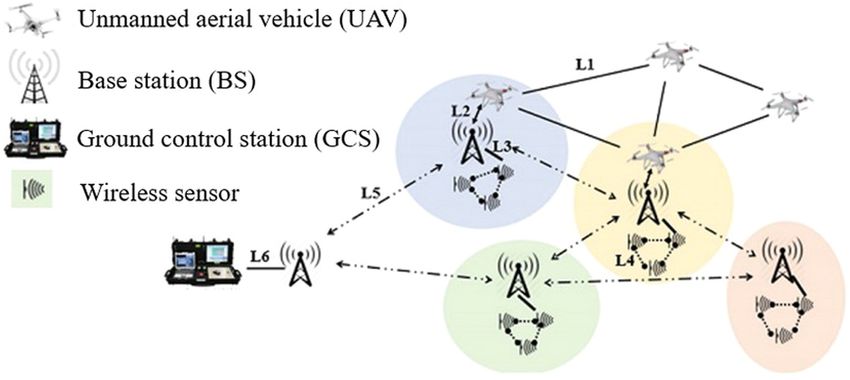
sensor network (WSN). Thus, the multi-system communication architecture, as shown in Figure 1, has been
examined. Depending on the different tasks, the architecture will contain three networks:
• Air Ad-Hoc network for communication between drones;
• Ground-based WSN representing an interactive set of sensors installed in the geographical area at ground
level for monitoring and collection of various data, such as humidity, temperature, and pressure, in
autonomous mode.
• Mobile network that provides communication between the base station (BS) and the UAV or the GCS
command center. This network acts as a transponder between the GCS and UAV networks.
The architecture includes the GCS, also known as the Flight Planning and Control Station [31,32], and is
the operational command center for the UAV. The GCS allows the user to create a mission and administer
the drone flight, which facilitates the observation of the UAV as the station collects and displays all the data
on the drone status, the current command, and telemetry data.
Figure 1: The monitoring architecture of several UAVs [20].732 Dmitry Gura et al.
To date, a great variety of GCSs that can be used for different purposes is available worldwide as civil
and military applications [33]. Moreover, GCS can be software and have open source such as Mission
Planner (Windows, Mac OS X, Linux), APM Planner 2, and MAVProxy [34]. Moreover, there are autopilots
(such as Ardupilot) with their own Control Station software (Ardupilot Mega Planner) [35,36]. This surveil-
lance system combines six communication lines (Figure 1):
– L1 is a communication line between multiple UAVs, usually based on IEEE 802.11.
– L2 is responsible for communication between the BS and the UAV.
– L3 communication line between wireless sensor network and BS.
– L4 channel of communication between two nodes of WSN.
– L5 communication line between BS.
– L6 communication lines between GCS and BS.
The information must be continuously transmitted from the UAV to the GCS to control the UAV, i.e.,
there must be a bi-directional communication between them, providing telemetry, and sending commands
in real-time. The communication line from the UAV to the GCS is intended for telemetry. It contains flight
data collected by the drone, such as geographic location and streaming video captured by the camera
during the flight. The communication line from the GCS to the UAV sends the UAV control commands (e.g.,
changing the UAV direction).
3.1 The UAV signal processing architecture
As the tasks (targets) in which drones are used are important, the communication between the UAV and the
GCS must work in the protected spectrum. Besides, a backup satellite communication line should be
created. The main link is implemented via LTE or 5G, which is preferable because of low latency reasons.
However, a reserve connection increases reliability. Advanced security mechanisms should also be used to
avoid a situation when unauthorized users intercept control of the UAV. Figure 2 illustrates the architecture
of multiple UAV controls.
Figure 2: Scheme of the UAV signal processing architecture [33].Automated system for dispatching the movement of unmanned aerial vehicles 733
There are different communication architectures (network topologies) for establishing communication
between UAVs and ground terminals [33,37], which can be divided into two categories: star and grid [38,39]
(see Figure 3).
Figure 3: Different communication architectures [39].
The “star” topology is based on an infrastructure where each UAV is directly connected to a central
hub, which is usually a fifth-generation BS (see Figure 3). Thus, all flows are centralized, but the BS cannot
exchange data with an UAV out of range. In addition, the UAVs are not directly connected, even though
their actions must be synchronous to avoid collisions.
For this purpose, the connection between several UAVs passes through the BS, which in this case leads
to a long delay in signal transmission. A network topology integrating two or more “star” communication
architectures is called an “extended star.” In this architecture, several groups of UAVs are interconnected,
and for each group, there is a node CGS, which is responsible for data exchange and is directly connected to
the BS and. To exchange data between multiple groups of UAVs, the data must pass through the BS. The
problems of this network topology are high latency and high bandwidth requirements for the communica-
tion line. Besides, if the BS fails, the entire network also breaks down.
Another type of communication architecture is a cellular topology. In this network topology, there is no
centralized communication with the BS, i.e., each UAV can act as a transponder and can transmit data
between other UAVs without passing through the BS. This topology is based on Ad Hoc (Figure 3), i.e., there
is only one UAV, called mainstream, directly connected to the BS, which acts as a gateway between the BS
and other UAVs. It collects data from the UAV and transfers them to the BS, simultaneously sending
commands and information from the GCS to the UAV.
The specifics of this network topology are the presence of a single connection between the BS and all
the UAVs. Another topology, similar to the “extended star” is an extended grid network, which also
contains several groups, but all of them can transmit data to each other directly, without the need to
connect through the BS, and, as mentioned earlier, there is only one gateway to the UAV in direct connec-
tion with the BS (Figure 3). The advantages of grid topology are the support of communication between the
UAV, even when the BS failed, and less bandwidth for data transmission for the communication line
between the UAV and the BS. As already mentioned, a huge amount of information is transmitted between
the UAV and the GCS, which can be divided into service data and measured data.
Service data are the information exchanged between the UAV and GCS, including control commands,
status, reports, as well as all data for the UAV management. The details collected by sensors onboard during
the flight are classified as data that can be presented in various forms [40]. The main data are images and
videos taken by different types of cameras (optical, thermal, etc.). Because of the high speed and stability of
the network, these images and videos are transmitted to the NSU in real-time and displayed to the pilot
allowing for a correction of UAV actions. In addition, UAV transmits other information such as its speed,
battery charge level, altitude, and current flight mode.734 Dmitry Gura et al.
4 Discussion on security of routing protocol
The exchange of data between the GCS and UAV is determined by various protocols, such as the MAVLink
protocol (Micro Air Vehicle Link), which is the most standardized communication protocol used in the data
channel for the UAV, or STANAG 4586 protocol. The MAVLink is an open-source protocol used to exchange
messages between autopilot and GCS [41,42], i.e., it receives telemetry data from the UAV and transmits
control and navigation commands.
The MAVLink [43] presents a list of the available common MAVLink messages set, executed by the
majority of GCSs and autopilots. MAVLink is a simple protocol tested on several platforms of the UAV and
numerous software for the GCS. It can communicate between 255 UAVs controlled by only one UAV. The
minimum package length in the MAVLink protocol is 8 bytes, and the maximum – 263 bytes at full payload.
Figure 4 shows the structure of the MAVLink command, and Table 1 shows a detailed description of this
MAVLink package.
Figure 4: The structure of MAVLink command.
Table 1: Details of the MAVLink package
Region Meaning Target
STX 0xFE Indicates the beginning of a new package
LEN 0–255 Specifies the length of payload
SEQ 0–255 Includes package loss detection
SYSID 1–255 Includes package loss detection
COMP 0–255 Defines the number of interacting UAVs
MSG 0–255 Defines the message to be sent
PAYLOAD 0–255 Messages data
CKA, CKB CRC options
Security is crucial for any communication protocol to guarantee the reliable and safe transmission of
data between network components. However, the MAVLink protocols have security gaps, and the
researchers are addressing these problems [44–46]. The previous section focused on the architecture of
communication between the UAV and GCS. The various network topologies available for different applica-
tion purposes were presented, followed by mentioning a data exchange. As follows from the architecture
presented in Figure 1, numerous network technologies can be applied in the communication system
between the UAV and GCS. Table 2 highlights the principal characteristics of different communication
technologies, which allows classifying them by range and speed of data transmission. Thus, for short-
distance communication, the WIFI (802.11) or ZigBee is suitable, i.e., cellular network, WiMAX, or satellite
communication is preferable to cover a large area. In addition, the bandwidth requirements for video and
images are not the same as for commands or GPS data. Therefore, when selecting network technologies, the
purposes of UAV usage should be taken into account.
This article discussed the standard architecture and the interactions between GCS and UAV. However,
some issues are disabling their successful practical use, namely: Ubiquity: users must control the UAV and
access the UAV system at any time from any device. Limited resources: A surveillance task requires a lot of
data, while the UAV has limited storage and power capacity. Therefore, an architecture that does notTable 2: Comparison of technologies for communication channels
Technology Theoretical speed Range Advantages Restrictions Data traffic
Satellite [1,47] 10 Mbps output; 1 Gbps All over the earth Broad coverage provides Limited bandwidth; high delays; Real-time processing
reception communication in all areas low data transfer rates; high cost
IEEE 802.11(a,g) 54 Mbps 30 m High speed Limited range; limited user support Control commands; telemetry data
IEEE 802.11(b) Up to 11 Mbps 75–100 m from UAV sensors
IEEE 802.11(n) Up to 300 Mbps 75 m
IEEE 802.11(ac) Up to 866.7 Mbps 35 m
[1,48,49]
GSM Up to 9.6 kbps Depends on the BS Extended coverage duplication High cost Control commands; telemetry data
GPRS Up to 144 kbps (from 1 to several km) One infrastructure for from UAV sensors (pictures and video)
multiple UAVs
UMTS Up to 2 Mbps High bandwidth and mobility
LTE 1 Gbps
5G [1,50] 10 Gbps or more
WiMAX [50,51] 70 Mbps Up to 50 km High bandwidth Interference issues Control commands; telemetry data
Low cost from UAV sensors (pictures and video)
Easy to use
High mobility
ZigBee [52] 250 kbps Up to 30 m Low cost Low data transfer rate; short range Control commands
coverage
Bluetooth 1 Mbps Up to 30 m Low cost Low data transfer rate; short range; Data transfer between UAVs
IEEE 802.15 [1] low safety
Automated system for dispatching the movement of unmanned aerial vehicles
735736 Dmitry Gura et al.
consume their resources is preferable. Real-time management: UAV task allocation, mission status monitoring,
and flight path must be provided in real-time. Moreover, unmanned aircraft require real-time communication
with each other to indicate their location and status to provide common work and complete the mission.
Reliable connection: drones require a permanent connection and a reliable communication channel.
However, the communication network may not be available, especially in remote areas. Besides, data
must be transmitted securely and protected from external attacks. Scalability: adding a new component to
the system must be safe and easy. Therefore, in urgent cases, a new UAV be attached to the mission directly
in real time, if needed. It has been established that this architecture must be improved to meet the
requirements. On the other hand, new concepts such as the Internet of Things (IoT) [53], Cloud [51], and
SDN [52] have gained popularity recently as they have become applicable in many industries, including the
UAV network, because of their extended functionality.
In fact, IoT is responsible for establishing and facilitating communication between things via the
Internet. The Cloud provides flexibility and accessibility from any place at any time, as well as storage
and computation of data collected from devices over the Internet. Finally, the SDN, which is responsible for
managing the heterogeneous environment, ensures synchronization in the network. Therefore, future
research will focus on these concepts, which are becoming more and more complicated to solve the
restrictions and problems of a UAV network system.
5 Conclusion
The paper presented the analysis results on the features of communication system architecture for UAV
control using GCS. It was shown that an effective and autonomous drone control system from the ground
terminal requires a minimum of six communication lines. The analysis of different communication topo-
logies revealed that the communication configuration can vary from “star” to “grid” topology depending on
the purpose and the security level of data transmitted. Some reliability problems were discussed, the
solution of which can be the use a backup connection via satellite, that is, a second connection. The study
of the basic characteristics of different communication technologies showed that for short-range communi-
cation, the WIFI (802.11) or ZigBee cellular communication are suitable, while WiMAX or satellite communi-
cation is preferable for covering a large area. However, some problems hindered the successful practical use
of UAV control systems, such as limited access to the UAV system, limited resources, real-time control pos-
sibility, and reliable connectivity. These problems can be solved by applying SDN and IoT technologies in
future research.
Funding information: This research did not receive any specific grant from funding agencies in the public,
commercial, or not-for-profit sectors.
Conflict of interest: The authors declare that they have no conflict of interests.
References
[1] Jawhar I, Mohamed N, Al-Jaroodi J, Agrawal DP, Zhang S. Communication and networking of UAV-based systems:
classification and associated architectures. J Netw Comput Appl. 2017;84:93–108.
[2] Hoffer NV, Coopmans C, Jensen AM, Chen Y. A survey and categorization of small low-cost unmanned aerial vehicle system
identification. J Intell Robot Syst. 2014;74:129–45.
[3] Gatteschi V, Lamberti F, Paravati G, Sanna A, Demartini C, Lisanti A, et al. New frontiers of delivery services using drones:
a prototype system exploiting a quadcopter for autonomous drug shipments. In 2015 IEEE 39th Annual Computer Software
and Applications Conference. Vol. 2. Piscataway: IEEE; 2015. p. 920–7.Automated system for dispatching the movement of unmanned aerial vehicles 737
[4] Borsuk GM, Coffey T. Moore’s Law: a department of defense perspective (No. 30). Washington, DC: Center for Technology
and National Security Policy, National Defense University; 2003.
[5] Torresan C, Berton A, Carotenuto F, Di Gennaro SF, Gioli B, Matese A, et al. Forestry applications of UAVs in Europe:
a review. Int J Remote Sens. 2017;38:2427–47.
[6] Eisenbeiss H. The autonomous mini helicopter: a powerful platform for mobile mapping. Int Arch Photogramm Remote
Sens Spat Inf Sci. 2008;37(B1):977–83.
[7] Barr A. Amazon testing delivery by drone, CEO Bezos says. USA: USA TODAY; 2013. Available from: https://www.usatoday.
com/story/tech/2013/12/01/amazon-bezos-drone-delivery/3799021/. Accessed September 26, 2020.
[8] Chamberlain P. Drones and journalism. Vol. 4, London: Taylor & Francis; 2017.
[9] Costa FG, Ueyama J, Braun T, Pessin G, Osório FS, Vargas PA. The use of unmanned aerial vehicles and wireless sensor
network in agricultural applications. In 2012 IEEE International Geoscience and Remote Sensing Symposium. Piscataway:
IEEE; 2012. p. 5045–8
[10] Matese A, Toscano P, Di Gennaro SF, Genesio L, Vaccari FP, Primicerio J, et al. Intercomparison of UAV, aircraft and
satellite remote sensing platforms for precision viticulture. Remote Sens. 2015;7:2971–90.
[11] Dockrill P. Facebook is preparing its Internet-beaming drone for maiden launch. Sciencealert; 2016. Available from:
https://www.sciencealert.com/facebook-is-preparing-its-internet-beaming-drone-for-maiden-launch. Accessed
September 26, 2020.
[12] Wang Y, Zhang MX, Zheng YJ. A hyper-heuristic method for UAV search planning. International Conference on Swarm
Intelligence. Cham: Springer; 2017. p. 454–64.
[13] Chaves AN, Cugnasca PS, Jose J. Adaptive search control applied to search and rescue operations using unmanned aerial
vehicles (UAVs). IEEE Lat Am Trans. 2014;12:1278–83.
[14] Berrahal S, Kim JH, Rekhis S, Boudriga N, Wilkins D, Acevedo J. Border surveillance monitoring using quadcopter
UAV-aided wireless sensor networks. J Commun Softw Syst. 2016;12:67–82.
[15] Mozaffari M, Saad W, Bennis M, Nam YH, Debbah M. A tutorial on UAVs for wireless networks: applications, challenges,
and open problems. IEEE Commun Surv Tutor. 2019;21:2334–60.
[16] Koh LP, Wich SA. Dawn of drone ecology: low-cost autonomous aerial vehicles for conservation. Trop Conserv Sci.
2012;5:121–32.
[17] Vermeulen C, Lejeune P, Lisein J, Sawadogo P, Bouche P. Unmanned aerial survey of elephants. PLoS One. 2013;8:e54700.
[18] Sweeney KL, Helker VT, Perryman WL, LeRoi DJ, Fritz LW, Gelatt TS, et al. Flying beneath the clouds at the edge of the
world: using a hexacopter to supplement abundance surveys of Steller sea lions (Eumetopias jubatus) in Alaska.
J Unmanned Veh Syst. 2016;4:70–81.
[19] Goebel ME, Perryman WL, Hinke JT, Krause DJ, Hann NA, Gardner S, et al. A small unmanned aerial system for estimating
abundance and size of Antarctic predators. Polar Biol. 2015;38(5):619–30.
[20] Guido G, Gallelli V, Rogano D, Vitale A. Evaluating the accuracy of vehicle tracking data obtained from unmanned aerial
vehicles. Int J Sustain Transp Technol. 2016;5:136–51.
[21] Bekmezci I, Sahingoz OK, Temel Ş. Flying ad-hoc networks (FANETs): a survey. Ad Hoc Netw. 2013;11:1254–70.
[22] Walendziuk W, Oldziej D, Binczyk DP, Slowik M. Ground control station software design for micro aerial vehicles.
In Photonics applications in astronomy, communications, industry, and high energy physics experiments 2017.
Vol. 10445. Wilga, Poland: International Society for Optics and Photonics; 2017. p. 1044564.
[23] Barritt B, Kichkaylo T, Mandke K, Zalcman A, Lin V. Operating a UAV mesh & internet backhaul network using
temporospatial SDN. In 2017 IEEE Aerospace Conference. Big Sky, MT, USA: IEEE; 2017. p. 1–7.
[24] Sharma V, Song F, You I, Chao HC. Efficient management and fast handovers in software defined wireless networks using
UAVs. IEEE Network. 2017;31(6):78–85.
[25] Maxa JA, Mahmoud MSB, Larrieu N. Survey on UAANET routing protocols and network security challenges. PKP Publishing
Services Network; 2017. Available from: https://hal-enac.archives-ouvertes.fr/hal-01465993/document. Accessed
September 26, 2020.
[26] Li B, Jiang Y, Sun J, Cai L, Wen CY. Development and testing of a two-UAV communication relay system. Sensors.
2016;16:1696.
[27] Gupta L, Jain R, Vaszkun G. Survey of important issues in UAV communication networks. IEEE Commun Surv Tutor.
2015;18(2):1123–52.
[28] Xiong F, Li A, Wang H, Tang L. An SDN-MQTT based communication system for battlefield UAV swarms. IEEE Commun Mag.
2019;57(8):41–7.
[29] Oubbati OS, Lakas A, Zhou F, Güneş M, Lagraa N, Yagoubi MB. Intelligent UAV-assisted routing protocol for urban VANETs.
Comput Commun. 2017;107:93–111.
[30] Atoev S, Kwon OJ, Kim CY, Lee SH, Choi YR, Kwon KR. The secure UAV communication link based on OTP encryption
technique. In 2019 Eleventh International Conference on Ubiquitous and Future Networks (ICUFN). Zagreb, Croatia: IEEE;
2019. p. 1–3.
[31] Krichen L, Fourati M, Fourati LC. Communication architecture for unmanned aerial vehicle system. In International
Conference on Ad-Hoc Networks and Wireless. Cham: Springer; 2018. p. 213–25738 Dmitry Gura et al.
[32] Bulat PV, Zasukhin ON, Upyrev VV, Silnikov MV, Chernyshov MV. Base pressure oscillations and safety of load launching
into orbit. Acta Astronautica. 2017;135:150–60.
[33] Lissandrini N, Michieletto G, Antonello R, Galvan M, Franco A, Cenedese A. Cooperative optimization of UAVs formation
visual tracking. Robotics. 2019;8:52.
[34] Zaheer Z, Usmani A, Khan E, Qadeer MA. Aerial surveillance system using UAV. In 2016 Thirteenth International
Conference on Wireless and Optical Communications Networks (WOCN). Piscataway: IEEE; 2016. p. 1–7.
[35] Mission Planner Ground Control Station; 2018. Available from: https://ardupilot.org/planner/docs/mission-planner-
ground-control-station.html. Accessed September 26, 2020.
[36] Bulat PV, Volkov KN, Ilyina TY. Interaction of a shock wave with a cloud of particles. Math Edu. 2016;11(8):2949–62.
[37] Schalk LM. Communication links for unmanned aircraft systems in very low-level airspace. In 2017 Integrated
Communications, Navigation and Surveillance Conference (ICNS). Piscataway: IEEE; 2017. p. 6B2–1.
[38] Frew EW, Brown TX. Airborne communication networks for small unmanned aircraft systems. Proceedings of the IEEE.
2008;96:10401570.
[39] Khan MA, Qureshi IM, Khanzada F. A hybrid communication scheme for efficient and low-cost deployment of future flying
ad-hoc network (FANET). Drones. 2019;3:16.
[40] Andre T, Hummel KA, Schoellig AP, Yanmaz E, Asadpour M, Bettstetter C, et al. Application-driven design of aerial
communication networks. IEEE Commun Magaz. 2014;52:129–37.
[41] Del Arco JC, Alejo D, Arrue BC, Cobano JA, Heredia G, Ollero A. Multi-UAV ground control station for gliding aircraft. In 2015
23rd Mediterranean Conference on Control and Automation (MED). Piscataway: IEEE; 2015. p. 36–43.
[42] Santos N, Raimundo A, Peres D, Sebastião P, Souto N. Development of a software platform to control squads of unmanned
vehicles in real-time. In 2017 International Conference on Unmanned Aircraft Systems (ICUAS). Piscataway: IEEE; 2017.
p. 1–5.
[43] MAVLink. MAVLink common message set; 2020. Available from: https://mavlink.io/en/messages/common.html.
Accessed September 26, 2020.
[44] Rivas A, Chamoso P, González-Briones A, Corchado JM. Detection of cattle using drones and convolutional neural
networks. Sensors. 2018;18:2048.
[45] Kwon YM, Yu J, Cho BM, Eun Y, Park KJ. Empirical analysis of MAVLink protocol vulnerability for attacking unmanned aerial
vehicles. IEEE Access. 2018;6:43203–12.
[46] Ostrikov A, Ospanov A, Vasilenko V, Muslimov N, Timurbekova A, Jumabekova G. Melt flow of biopolymer through the
cavities of an extruder die: mathematical modelling. Math Biosci Eng. 2019;16(4):2875–905.
[47] Sánchez-García J, García-Campos JM, Arzamendia M, Reina DG, Toral SL, Gregor D. A survey on unmanned aerial and
aquatic vehicle multi-hop networks: wireless communications, evaluation tools and applications. Comp Commun.
2018;119:43–65.
[48] Pareek D. The business of WiMAX. New York: John Wiley; 2006.
[49] Kiran K, Vaishnavi K, Shenoy PD, Venugopal KR. Throughput analysis in an infrastructure-based mesh network using
BeeHive algorithm. Int J Appl Inform Syst. 2017;11:1–9.
[50] Šuľaj P, Haluška R, Ovseník Ľ, Marchevský S, Pulli P, Kramar V. UAV Management system for the smart city. Piscataway:
IEEE; 2018.
[51] Chaâri R, Ellouze F, Koubâa A, Qureshi B, Pereira N, Youssef H, et al. Cyber-physical systems clouds: a survey.
Comp Networks. 2016;108:260–78.
[52] Zhang X, Wang H, Zhao H. An SDN framework for UAV backbone network towards knowledge centric networking. In IEEE
INFOCOM 2018-IEEE Conference on Computer Communications Workshops (INFOCOM WKSHPS). Piscataway: IEEE; 2018.
p. 456–61
[53] Shaikh Z, Baidya S, Levorato M. Robust multi-path communications for UAVs in the urban IoT. In 2018 IEEE International
Conference on Sensing, Communication and Networking (SECON workshops). Piscataway: IEEE; 2018. p. 1–5You can also read