Archaeological Impact Statement - for the development of a relief road at Thurles, Co. Tipperary - Hidden Tipperary
←
→
Page content transcription
If your browser does not render page correctly, please read the page content below
Planning Ref. No.: N/A
IG: 213211.375/158072.724
RMP: TN041‐043‐‐‐
ÆGIS REF.: 210‐11

Archaeological Impact
Statement
for the development of a relief
road at Thurles, Co. Tipperary

Report Author: F. Coyne BA MIAI

Client:       c/o Michael Devery,
              SEE Road Design,
              North Tipperary County
              Council,
              Civic Offices,
              Nenagh, Co. Tipperary

Date:          October 2013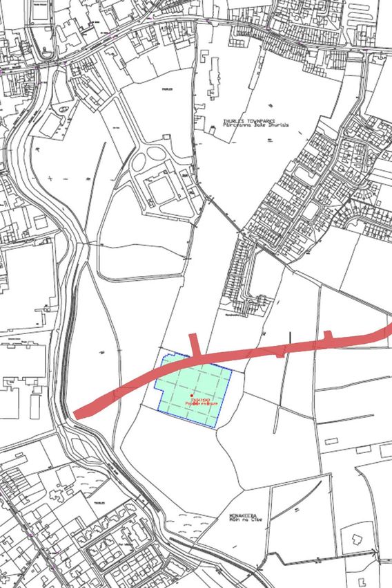
Archaeological Impact Statement
                                                                        for a relief road at Thurles, Co. Tipperary

Copies of this report   Client — C/o Michael Devery, SEE Road Design, North Tipperary County Council,
have been               Civic Offices, Nenagh, Co. Tipperary
presented by ÆGIS
to:

Please note…            That the archaeological recommendations, mitigation proposals and suggested
                        methodology followed in this report are similar to those used on previous similar
                        projects approved by the Archaeological Planning and Licencing Unit National
                        Monuments Service, Room G50, Custom House, Dublin 1 The National
                        Monuments Acts 1930‐2004, The Planning and Development Act 2002 (plus any
                        amendments) and the most recent EPA guidelines were consulted. Guidelines and
                        Plans issued from time‐to‐time by the statutory bodies have been consulted.
                        These are listed in the reference section of this report. Every effort has been taken
                        in the preparation and submission of this report to provide as complete an
                        assessment as possible within the terms of the brief, and all statements and
                        opinions are offered in good faith. However, ÆGIS cannot accept responsibility for
                        errors of fact or opinion resulting from the data supplied by any third party, for
                        any loss or other consequences arising from decisions made or actions taken on
                        the basis of facts and opinions expressed in this report, (and any supplementary
                        information), howsoever such facts and opinions may have been derived, or as the
                        result of unknown and undiscovered sites or artefacts.

Acknowledgements        ÆGIS acknowledges the information supplied by the client and information
                        gathered from the Archaeological Survey of Ireland supplied SMR information.

Report Design and       ÆGIS Archaeology Limited 2008.
Template

Copyright Note          Please note that the entirety of this report, including any original drawings and
                        photographs, remain the property of the client and author(s) and ÆGIS
                        ARCHAEOLOGY LIMITED. Any reproduction of the said report requires the written
                        permission of ÆGIS ARCHAEOLOGY LTD. Images and drawings supplied by third
                        parties are acknowledged individually.

Ordnance Survey of      Where Ordnance Survey of Ireland (OSI) material has been reproduced in this
Ireland Licence         report it has been done so under licence AR0095413. © Ordnance Survey of
                        Ireland/Government of Ireland.

Cover Image             View of subject site. Taken by F. Coyne 2013.

                                                                                   ÆGIS ARCHAEOLOGY LIMITED
                                                                                                REF.: 210‐11
                                                    2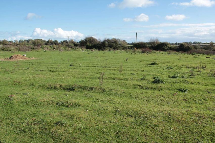
Archaeological Impact Statement
                                                   for a relief road at Thurles, Co. Tipperary

Contents
                                                                          page
I. List of Figures, Plates & Tables                                       4
II. Glossary of Terms                                                     5

1. Scope of Study                                                         6

2. Method of Study                                                        7

3. Existing Environment                                                   8
3.1 The Site Inspection                                                   10
3.2 The Proposed Development                                              20

4. History & Archaeology of the Site & Vicinity                           21
4.1 Historical & Archaeological Background                                21
4.2 Previous Archaeological Work in the Vicinity                          27
4.3 Protected Structures                                                  50

5. Impact of the Proposed Development                                     51
5.1 The Predicted Impacts                                                 51
5.2 The ‘Worst Case’ Scenario                                             51
5.3 Interaction of Impacts                                                51

6. Conclusions & Suggested Mitigation                                     52

7. Non‐Technical Summary                                                  54

8. Signing‐Off Statement                                                  56

9. Project References                                                     57

                                                              ÆGIS ARCHAEOLOGY LIMITED
                                                                           REF.: 210‐11
                                              3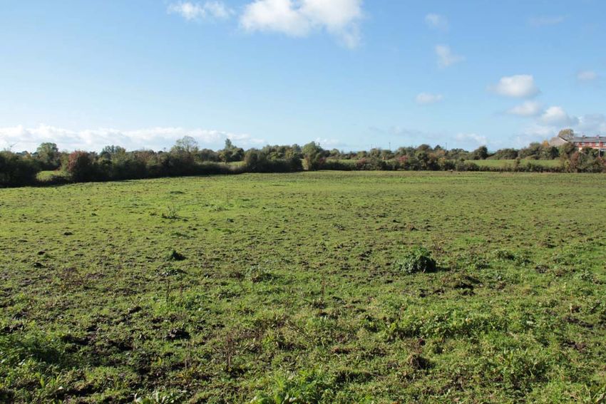
Archaeological Impact Statement
                                                                          for a relief road at Thurles, Co. Tipperary

                                I. List of Figures, Plates & Tables

FIGURES                                                                                                      page
1. Site Location, Ordnance Survey Ireland©.                                                                    8
2. Location of road in red at Thurles, after Ordnance Survey Ireland                                           9
3. Aerial view of site on, location of road in red, after www.bing.com.                                        9
4. Location map with fields numbered                                                                          10
5. Location of proposed relief road                                                                           20
6. Map (after ASI) showing closest recorded archaeological monuments.                                         23
7. RMP Map showing location of proposed road                                                                  23
8. First Edition map c. 1840                                                                                  25
9. 25 inch map, proposed road in red                                                                          25
10. Location of geophysical survey                                                                            27
11. Detail of geophysical survey                                                                              28

PLATES
1. Field 1, from E                                                                                            12
2. Field 2, from E                                                                                            12
3. Field 3, from E                                                                                            13
4. Field 4, from E                                                                                            13
5. Field 5, from E                                                                                            14
6. Ridges in Field 5, from W                                                                                  14
7. Field 6, from W                                                                                            15
8. Field 7, from E                                                                                            15
9. Field 7, general location of RMP TN041‐043‐‐‐ from E                                                       16
10. Field 8, from E                                                                                           16
11. Field 9, from E                                                                                           17
12. Field 9,mounds and rushes, from E                                                                         17
13. RMP TN041‐044‐‐‐, from NW                                                                                 18
14. View along Mill Road adjacent to TN041‐044‐‐‐, from N                                                     18
15. View along Mill Road close to Field 1, from S                                                             19
16. .Location of proposed road through car park area at Slievenamon Road, from W                              19

TABLES
1. Monuments in Thurles taken from the Urban Archaeology Survey                                               22
2. List of finds from the vicinity of the proposed road                                                       26
3. List of Protected Structures on Slievenamon Road                                                           50

                                                                                     ÆGIS ARCHAEOLOGY LIMITED
                                                                                                  REF.: 210‐11
                                                      4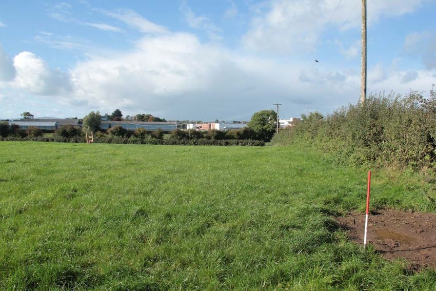
Archaeological Impact Statement
                                                                                        for a relief road at Thurles, Co. Tipperary

                                                                       II. Glossary of Terms

           ASI     Archaeological Survey of Ireland, a division of the DoAHG
Barony, Parish,    These terms refer to land divisions in Ireland. The barony is the largest land division in a county, which
    Townland       is formed from a number of parishes. These parishes are in turn made up of several townlands, which
                   are the smallest land division in the country. The origins of these divisions are believed to be in the
                   Early Medieval/Christian period (AD500‐AD1000), or may date earlier in the Iron Age (500BC‐AD500)
        DoAHG      Department of Arts, Heritage and the Gaeltacht. The governmental department whose heritage remit
                   includes a range of policy, regulatory, educational and promotional roles.
               E   East
   First Edition   This relates to editions of the OS 6 inch maps for each county. The first edition map completed for the
                   area dates to the early 1840s and this is referred to in the text as the “First Edition”
            KM     Kilometre
             M     Metres, all dimensions are given in metres or part of a metre, unless otherwise stated
             N     North
          NGR      National Grid Reference
          NIAH     National Inventory of Architectural Heritage
           NMI     National Museum of Ireland
          NMS      National Monuments Service. Regulatory body with the DoAHG with responsibility for archaeological
                   heritage. A division of the DoAHG.
           OS      Ordnance Survey
           OSI     Ordnance Survey of Ireland
          RMP      Record of Monuments and Places. An update of the older SMR, (sites and monuments record), on
                   which all known archaeological sites are marked and listed in an accompanying list. The sites marked
                   afford legal protection under the National Monuments Acts 1930‐2004. The record is based on the 6‐
                   inch map series for the country and is recorded on a county basis. Each archaeological monument on
                   the RMP has a unique code known as the RMP number prefixed by TS for Tipperary (South Riding).
 RMP Number        This code is the number of the site on the RMP constraint map. It begins with the county code, the 6‐
                   inch sheet number, followed by the number of the archaeological monument on that sheet
           RPS     Record of Protected Structures
             S     South
         Sheet     This relates to the 6‐inch map for each county, which is divided into sheets
          SMR      Sites and Monuments Record. The precursor of the RMP, the SMR now commonly relates to the
                   archive paper files of known archaeological monuments maintained by the Archaeological Survey of
                   Ireland (ASI). These files are arranged according to RMP number
             TB    Townland Boundary
             W     West

                                                                                                     ÆGIS ARCHAEOLOGY LIMITED
                                                                                                                  REF.: 210‐11
                                                               5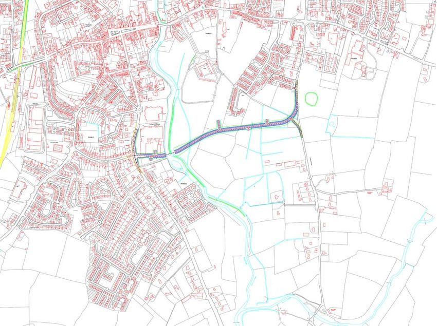
Archaeological Impact Statement
                                                                      for a relief road at Thurles, Co. Tipperary

                                                                 1. Scope of Study

This report identifies and assesses the potential direct and indirect impact(s), if any, on the potential
archaeological environment of a proposed relief road in the townlands of Clongower and
Monakeeba, Glebe and Mullauns, Thurles, Co. Tipperary.

This report fulfils the usual criteria of an archaeological impact assessment and follows the most
recent EPA guidelines on the compilation of an EIS (2002; 2003). Pertinent guidelines published from
time‐to‐time have also been consulted and are listed in the project references given at the back of
this report. A brief historical introduction to the area is provided and archaeological features in the
vicinity, including any standing remains, are discussed. The report details the potential
archaeological and/or cultural heritage features on the site and in its vicinity and discusses the
impacts, if any, of the development on that archaeology and/or cultural heritage.

No intrusive archaeological investigations (test‐trenching or excavation) have been undertaken at
this stage or as part of this desktop assessment. However a geophysical assessment has been carried
out under licence number 13R11 at the location of RMP TN041‐043‐‐‐ enclosure.

The site inspection on which this report is based was carried out on Wednesday 23rd October2013.

                                                                                 ÆGIS ARCHAEOLOGY LIMITED
                                                                                              REF.: 210‐11
                                                   6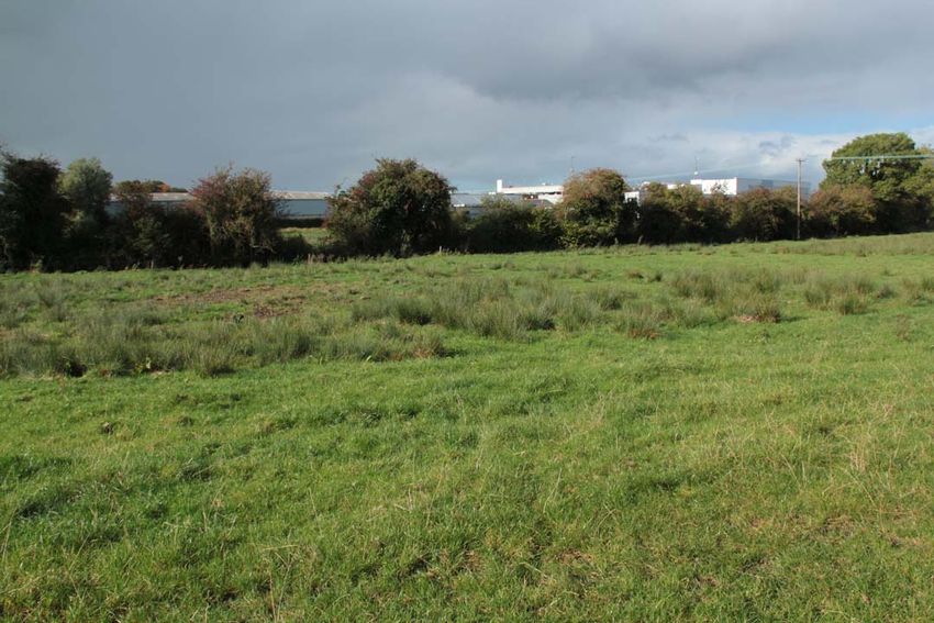
Archaeological Impact Statement
for a relief road at Thurles, Co. Tipperary
2. Method of Study
The following resources and methods of establishing the archaeological status of the site of the
stone quarry were used:
The subject site was visited and inspected by a qualified archaeologist;
The Record of Monuments and Places constraint maps and lists (RMP) and the sites and
monuments record archive (SMR) were examined;
A wide range of local historical and archaeological records relevant to the study area were
consulted, including the Ordnance Survey First Edition six‐inch map (c.1840), the Ordnance
Survey twenty‐five inch map and aerial views;
Thurles and Environs Development Plan 2009‐2015;
National Inventory of Architectural Heritage;
Topographical Files held in the National Museum of Ireland;
Archaeological Survey of Ireland files and publications;
A review of any archaeological investigations in the vicinity was also undertaken.
ÆGIS ARCHAEOLOGY LIMITED
REF.: 210‐11
7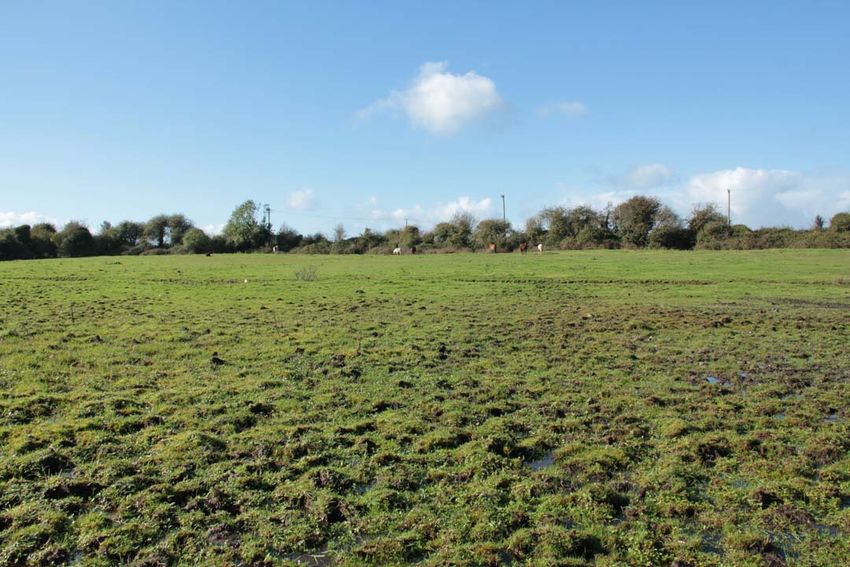
Archaeological Impact Statement
for a relief road at Thurles, Co. Tipperary
3. Existing Environment
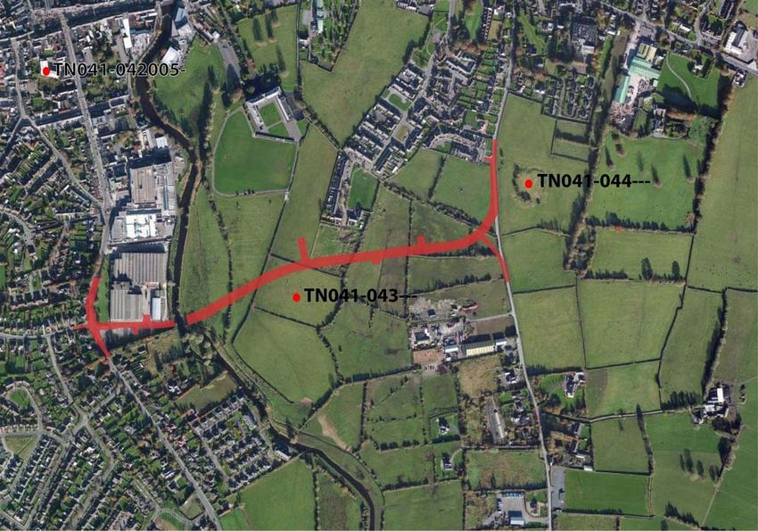
The subject site lies on the south‐eastern side of Thurles town, in an area of open fields through the
townlands of Clongower and Monakeeba, then along the roadway which is also the townland
boundary between Glebe and Monakeeba, and Mullauns and Monakeeba.
Figure 1. Site Location, Ordnance Survey Ireland©
ÆGIS ARCHAEOLOGY LIMITED
REF.: 210‐11
8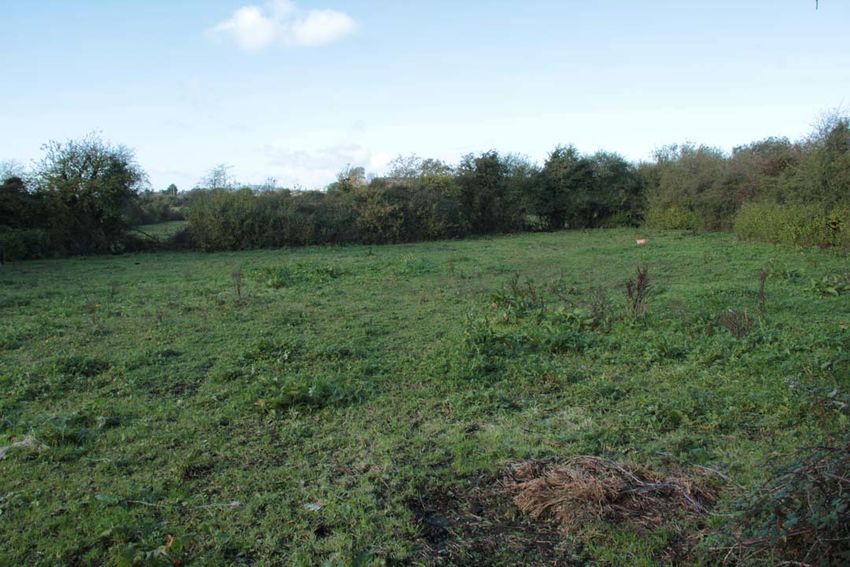
Archaeological Impact Statement
                                                              for a relief road at Thurles, Co. Tipperary

Figure 2. Location of road in red at Thurles, after Ordnance Survey Ireland©.

Figure 3. Aerial view of site on, location of road in red, after www.bing.com

                                                                          ÆGIS ARCHAEOLOGY LIMITED
                                                                                       REF.: 210‐11
                                     9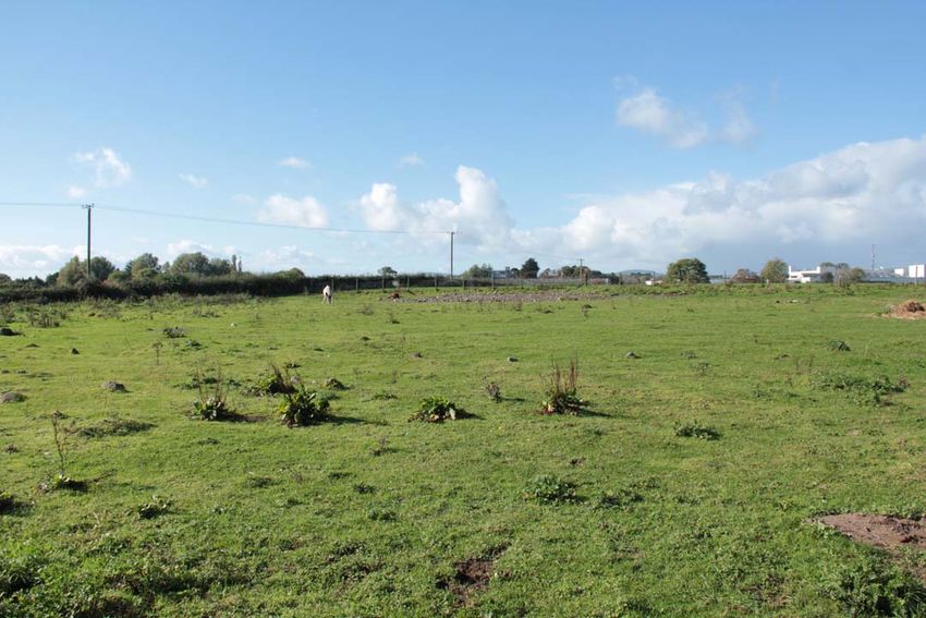
Archaeological Impact Statement
                                                                                    for a relief road at Thurles, Co. Tipperary

3.1 The Site Inspection (plates 1‐16)
The subject site was inspected on Wednesday 23rd October 2013. Weather conditions were showery.
The subject site is a series of fields. For ease of reporting they were numbered in the direction in
which they were walked, from east to west, (see figure below), and numbered F1 to F9.

                   Figure 4. Location map with fields numbered (supplied by client, annotated by writer)

The proposed road will run along Mill Road, past RMP TN41‐044‐‐‐, before entering the green field
area.

Field 1 is a small field, covered in short grass and grazed by horses.

Field 2 is a large open grassy field, covered in short grass and grazed by horses.

Field 3 is a large open grassy field, covered in short grass and grazed by horses. It is very wet
underfoot.

                                                                                                ÆGIS ARCHAEOLOGY LIMITED
                                                                                                             REF.: 210‐11
                                                            10
Archaeological Impact Statement
for a relief road at Thurles, Co. Tipperary
Field 4 is a large open grassy field, covered in short grass and grazed by horses. It is extremely wet
underfoot.
Field 5 is a rectangular grassy field, located to the rear (south) of a housing estate. It is covered in
short grass and grazed by horses. Mounds of rubble and topsoil are located at the eastern side of the
field. Traces of cultivation ridges are to be seen throughout this field.
Field 6 is a large open grassy field, covered in short grass and grazed by cattle. It is located along a
natural ridge which runs in a general north‐south direction, and is drier than the land to the east and
west.
Field 7 is a large open grassy field, covered in short grass. It is located along a natural ridge which
runs in a general north‐south direction, and is drier than the land to the east and west. The RMP
TN041‐043‐‐‐ is located in this field along the crest of this ridge.
Field 8 slopes from a high at east to lower ground at west, where rushes grow in abundance, possibly
marking an old pond area. Traces of an old field boundary, running in an east‐west direction was also
noted in this field.
Field 9 contains several undulations, growths of rushes and is wet underfoot, and is adjacent to the
river. It has the potential to contain previously unrecorded wetland archaeological sites, such as
fulachta fiadh. The eastern side of the proposed bridge will be located in this field.
The proposed road will cross the River Suir at the location of a new bridge. At the western side of the
river, it will run through the car park area of an industrial estate, before joining with the Slievenamon
Road.
No previously unrecorded archaeological monuments were recorded during the inspection.
ÆGIS ARCHAEOLOGY LIMITED
REF.: 210‐11
11Archaeological Impact Statement
for a relief road at Thurles, Co. Tipperary
Plate 1. Field 1, from E
Plate 2. Field 2, from E
ÆGIS ARCHAEOLOGY LIMITED
REF.: 210‐11
12Archaeological Impact Statement
for a relief road at Thurles, Co. Tipperary
Plate 3. Field 3, from E
Plate 4. Field 4, from E
ÆGIS ARCHAEOLOGY LIMITED
REF.: 210‐11
13Archaeological Impact Statement
for a relief road at Thurles, Co. Tipperary
Plate 5. Field 5, from E
Plate 6. Ridges in Field 5, from W
ÆGIS ARCHAEOLOGY LIMITED
REF.: 210‐11
14Archaeological Impact Statement
for a relief road at Thurles, Co. Tipperary
Plate 7. Field 6, from W
Plate 8. Field 7, from E
ÆGIS ARCHAEOLOGY LIMITED
REF.: 210‐11
15Archaeological Impact Statement
for a relief road at Thurles, Co. Tipperary
Plate 9. Field 7, general location of RMP TN041‐043‐‐‐ from E
Plate 10. Field 8, from E
ÆGIS ARCHAEOLOGY LIMITED
REF.: 210‐11
16Archaeological Impact Statement
for a relief road at Thurles, Co. Tipperary
Plate 11. Field 9, from E
Plate 12. Field 9,mounds and rushes, from E
ÆGIS ARCHAEOLOGY LIMITED
REF.: 210‐11
17Archaeological Impact Statement
for a relief road at Thurles, Co. Tipperary
Plate 13. RMP TN041‐044‐‐‐, from NW
Plate 14. View along Mill Road adjacent to TN041‐044‐‐‐, from N
ÆGIS ARCHAEOLOGY LIMITED
REF.: 210‐11
18Archaeological Impact Statement
for a relief road at Thurles, Co. Tipperary
Plate 15. View along Mill Road close to Field 1, from S
Plate 16. Location of proposed road through car park area at industrial estate, Slievenamon Road, from W
ÆGIS ARCHAEOLOGY LIMITED
REF.: 210‐11
19Archaeological Impact Statement
for a relief road at Thurles, Co. Tipperary
3.2 The Proposed Development (Figures 4‐5)
The proposed scheme comprises approximately 1.1 km of new road with a new signalised junction
on the Slievenamon Road at its junction with Clongour Road, a new priority junction with Mill Road
and 4 intermediate priority junctions to provide access to traversed lands. The scheme includes a 50
metre span tied bowstring arch crossing of the Suir along with ancillary services drainage, ducting,
water mains and services.
Figure 5. Location of proposed relief road (supplied by client)
ÆGIS ARCHAEOLOGY LIMITED
REF.: 210‐11
20Archaeological Impact Statement
for a relief road at Thurles, Co. Tipperary
4. History & Archaeology of the Site &
Vicinity
4.1 Historical and Archaeological Background (Figures 5‐8)
The earliest reference to Thurles or Durlas ‐meaning strong fort (O’Donovan 1840) is in AD844 when
Saint Ciarán visited Durlas to punish Feidhlimid mac Crimthain for a raid on Clonmacnoise.
Subsequent battles in Thurles in AD1174 and AD1192 are recorded in the Annals. The first indication
of settlement is noted in a charter granted by Theobald Walter prior to 1206.
The castle at Thurles was besieged in 1208. It is believed to have been located close to the present
day location of the fifteenth/sixteenth century ‘Black Castle’, a rectangular tower house. By the early
fourteenth century the motte castle was at the centre of a complex of buildings including a courtyard
(bailey) and service buildings. This complex was replaced in the sixteenth and seventeenth centuries
with the Civil Survey recording a house ‘with a castle and several turrets upon the bawne’ (Simington
cited in Carey & Farrelly 1994).
There is mid to late fourteenth century murage evidence for Thurles, although no trace of the town
wall survives. Both fifteenth century tower houses at Black Castle and Bridge Castle may have been
mural towers associated with gates along the town wall. The proposed line of the town wall, noted in
the Urban Survey, is based on surviving street patterns and property boundaries. Thomas (1992) has
noted a difference in the structures and functionality within Thurles, noting that the east side of the
river contained the churches ‐ such as the fourteenth century friary and the later sixteenth century
church ‐ while the west side contained the market place, castle and gates. This is in a sense mirrored
today with the urban/industrial centre with housing located to the west and the more residential
and church associated buildings in the east of the town.
The Ursuline convent in Thurles was founded in AD1787 (www.utc.ie). A woman called Anastasia
Tobin came back to her native Thurles having been professed as Sr Clare Ursula in the Ursuline
Convent, Cork. She took up residence in a thatched cottage on the site of the present convent, and
ÆGIS ARCHAEOLOGY LIMITED
REF.: 210‐11
21Archaeological Impact Statement
for a relief road at Thurles, Co. Tipperary
thus was founded the convent and teaching institution (ibid.). Prior to 1970 the convent ran a farm
to the rear of the existing convent building (O’Brien 2008). That farm is no longer extant, and it is
these buildings and yard that comprise the subject site for the proposed development. The
farmyards are located directly to the west of a partially walled garden, the latter’s design believed to
be based on one of Sir Walter Raleigh’s gardens (Ursuline Sister, pers. comm.). The western wall of
this garden will be incorporated into the design of the proposed building (O’Brien 2008).
The Urban Archaeology Survey records a number of archaeological monuments in the town (Carey
and Farrelly 1994). These are:
Monument Date Location
Tower house ‘Black Castle’ 15 /16th century
th
North of West Gate/ Friar Street
Tower house ‘Bridge Castle’ 15th century East of Liberty Square near Barry’s
Bridge
Church (site) and Graveyard West of town to north of Garryvicleheen
‘St Bridget’s road
Motte (site) 12th century West end of town near Black Castle
Sheela‐na‐gig Back stone wall of Lyons’ Tyre &
Batteries centre opposite former bank
(GAA museum/office)
Bridge (possible) Over river Suir, joining the Square &
Cathedral Street
Town Wall (possible site) 14th century unlocated
Carmelite Friary (site) 13th/14th century On site of Cathedral of the Assumption
to east of river
Church and graveyard 400m east of Barry’s Bridge
a Archer Tomb 16th/17th century
b Graveslab 17th century
c Wall memorial 17th century
Castle (possible site) ‘Croak Was depicted on south side of Garver
Castle’ Clahen Street (now Friar Street). The site
of this castle is in the vicinity of the
development. See figure 3b
Table 1. Monuments in Thurles taken from the Urban Archaeology Survey (Farrelly and Carey 1994)
The Archaeological Inventory of County Tipperary (Farrelly and O’Brien 2002, 333) provides a
comprehensive account of the historic town of Thurles (inventory number 2249). The town itself is
situated in the townlands of Garryvicleheen, Monacocka and Thurles Townparks and was founded in
the late twelfth century when the motte at Thurles was constructed (inventory 2068).
ÆGIS ARCHAEOLOGY LIMITED
REF.: 210‐11
22Archaeological Impact Statement
for a relief road at Thurles, Co. Tipperary
Figure 6. Map (after ASI) showing closest recorded archaeological monuments (red dots) to proposed road (red line0)
Figure 7. RMP Map showing location of proposed road in relation to the historic town of Thurles (TN041‐042‐‐‐)
ÆGIS ARCHAEOLOGY LIMITED
REF.: 210‐11
23Archaeological Impact Statement
for a relief road at Thurles, Co. Tipperary
The proposed roadway is located to the south of the historic town of Thurles (TN041‐042‐‐‐).
The following description of the monuments closest to the proposed roadway (TN041‐043 and
TN041‐044‐‐‐) is taken from the ASI accessed via the National Monuments Service website
(www.archaeology.ie, accessed October 2013).
N041‐043‐‐‐‐‐
Class: Enclosure
Townland: Monakeeba
Description: Situated on summit of flat‐topped ridge running NNE‐SSW, in lush pasture. Site not
depicted on 1st (1843) or 2nd (1952‐53) ed. OS 6‐inch map but shows up as a circular crop mark on
aerial photograph (6156/6157 Ordnance Survey photo?). No visible trace of site. According to farm
manager (site owned by St. Patrick's college) the field had been tilled previously to a depth of 9" but
he never noticed any circular feature in this field.* Note; A geophysical survey was carried out at this site
in 2013 as part of this project (see below)
Compiled by: Jean Farrelly and Caimin O'Brien
Date of upload/revision: 22 September 2008
TN041‐044‐‐‐
Class: Enclosure
Townland: Glebe (Thurles Ph.)
Description: Situated on a gentle SE‐facing slope in gently undulating terrain. A large D‐shaped area
(dims. 79m N‐S; 72.5m E‐W) enclosed by an earth and stone bank (Wth 2.8m; int. H 0.63m; ext. H
1.44m). The SE side is almost straight although on the 1st ed. (1843) OS 6‐inch map it is depicted as
being circular. Evidence of a wide shallow external fosse exists in the SE sector only (Wth 5.8m; D
0.2m). A gap (Wth 3m) in the bank at S may be the original entrance and other gaps are broken
through the bank at W and NW. Portion of the bank has been quarried out at NNE. The site is known
locally as 'Killahilla' according to a priest at St Patrick's College.
The above description is derived from 'The Archaeological Inventory of County Tipperary. Vol. 1 ‐ North
Tipperary' compiled by Jean Farrelly and Caimin O'Brien (Dublin: Stationery Office, 2002).
ÆGIS ARCHAEOLOGY LIMITED
REF.: 210‐11
24Archaeological Impact Statement
for a relief road at Thurles, Co. Tipperary
Figure 7. First Edition map c. 1840, site indicated in red(after www.osi.ie ).
Figure 8. 25 inch map, proposed road in red (after www.osi.ie).
ÆGIS ARCHAEOLOGY LIMITED
REF.: 210‐11
25Archaeological Impact Statement
for a relief road at Thurles, Co. Tipperary
There is one archaeological artefact/find from the townland of Monakeeba, recorded in the National
Museum of Ireland files, and a number from Thurles and nearby.
Reg. Number Find Location Description
1996:54 Monakeeba Bronze socketed spearhead found in a boggy field
IA:184:88 Thurles Sheela‐na‐Gig, in a wall in Liberty square
5076:W45 Thurles Abbey Copper Alloy key
1941:1121 Bog near Thurles Copper alloy three‐legged ewer, 14th/15th century
6881:W87 Near Thurles Bronze mortar
R2561 Between Thurles Bronze Axehead, found in a railway cutiting
and Templemore
Table 2. List of finds from the vicinity of the proposed road
ÆGIS ARCHAEOLOGY LIMITED
REF.: 210‐11
26Archaeological Impact Statement
for a relief road at Thurles, Co. Tipperary
4.2 Previous Archaeological Work in the Vicinity
A geophysical survey was carried out on RMP TN041‐043‐‐‐ in February 2013, in which the location of
the crop mark visible on an aerial photograph was assessed under licence number 13R11.
Figure 9. Location of geophysical survey (after J.M. Leigh Surveys 2013)
ÆGIS ARCHAEOLOGY LIMITED
REF.: 210‐11
27Archaeological Impact Statement
for a relief road at Thurles, Co. Tipperary
Figure 10. Detail of geophysical survey (after J.M. Leigh Surveys 2013)
The conclusions of the Geophysical Survey report (Leigh 2013, 4) state;
• The possible enclosure (RMP TN041:043) has been clearly identified as a circular ditched
enclosure with a diameter of c.47m, which corresponds with the feature identified through
aerial photography. Although there are no clear responses evident within the enclosure,
there is an area of increased response, indicative of burning activity. A ‘gap’ in the enclosure
ditch is suggested in the north‐east and may represent an entranceway.
• A faint curvilinear response appears to extend south from the main circular enclosure, and
may represent an annex feature.
• Magnetically strong isolated responses to the north and south of the enclosure and are
located on the ridged plateau, and are of clear archaeological interest. They may represent
clusters of pits, possibly containing burnt material. Another cluster of responses to the west,
and located down slope, is also of possible archaeological interest. Although the responses
are less well defined, another cluster of pit type features may be located here.
ÆGIS ARCHAEOLOGY LIMITED
REF.: 210‐11
28Archaeological Impact Statement
for a relief road at Thurles, Co. Tipperary
No other previous licenced archaeological work was found to have been conducted within the
boundaries of the proposed development site as per a review of www.excavations.ie (the database
of licenced archaeological work (accessed October 2013) which is updated yearly and currently
contains summary accounts of all excavations from 1970 to 2010).
Several other licenced archaeological works have been carried out in Thurles and its immediate
vicinity, and are detailed below, as included on the list of licenced archaeological work included on
the www.excavations.ie database.
Tipperary
1995:261
Black Castle Theatre, Thurles
Urban
S128588
95E150
An archaeological assessment was carried out on a small development site close to the northern side of the
Black Castle, Thurles. The assessment was carried out after planning permission had been granted for a
theatre and community arts centre building and in response to a request by the Office of Public Works to the
local authority.
The site lies within the 'zone of archaeological potential' as defined by the OPW Urban Archaeological Survey
and also lies within the supposed circuit of the medieval town defences. Black Castle, near the site, is a
substantial, well‐preserved, 15th/16th‐century tower house which lies off Liberty Square in the centre of
Thurles. The tower house has part of an enclosing bawn wall still surviving. The development is positioned on
the north‐east side of the tower, less than 5m away from what is thought to represent the eastern bawn wall.
To the north‐west of the site, less than 50m from the development area, lies the site of a motte, a late 12th‐
century earthen castle which had substantial precincts by the 14th century. In addition, documentary sources
suggest that Thurles was a walled town in the medieval period. The line of the town wall is thought to have
run some distance to the west of the proposed development site, but the location has not been confirmed by
archaeological investigation.
The development site measures roughly 23m north‐south by 19m east‐west and is bordered on all sides by
light limestone walls. It lies outside the bawn area and also some 3‐5m inside the supposed line of the town
wall. The assessment sought to establish:(i) whether the western boundary wall might coincide with the line of
the town wall;(ii) whether a small semicircular arc in the southern boundary wall of the site, which appeared
to be at variance with the general orientation of the surrounding walls, might be associated with the tower
ÆGIS ARCHAEOLOGY LIMITED
REF.: 210‐11
29Archaeological Impact Statement
for a relief road at Thurles, Co. Tipperary
house (perhaps forming part of an outer medieval bawn wall) ;(iii) whether archaeological deposits exist on
the site. The proximity to the supposed location of the Anglo‐Norman motte was also borne in mind.
Prior to the archaeological assessment four trial‐holes had been opened for engineering site investigation
purposes in the four corners of the site. These indicated that there was a deep deposit of grey/black silt at the
southern end of the site and a natural gravel deposit at the northern end. The archaeological testing revealed
that:(i) both the southern and western boundary wall are post‐medieval in date; neither are associated with
the castle bawn or city wall;(ii) the semicircular arc in the southern site boundary wall was inserted possibly to
facilitate the inward opening of the gate;(iii) the upper levels of rubble and stones with the remains of the
mortar floor are also post‐medieval in date, as was a pit in the south‐west corner of the site;(iv) the possible
remains of a wall, probably orientated east‐west, were badly disturbed at the east of the site (Trench 2, which
was positioned parallel to Trench 1, did not pick up the line of a deep masonry foundation recorded in the
engineers' site log, indicating that it did not extend as far north as Trench 2);(v) a deep deposit of dark grey silt
with brown organic lenses beneath the upper rubble and stones extended to a depth of 3.7m below the
present ground level.
Although the organic silt material excavated was intensively searched for artefactual finds, no pottery or other
small items were retrieved. Of note, no animal bone or shell were recovered from this deposit. The silt
extended for 13m north of the boundary wall and could represent a ditch or fosse associated with the tower
house or the motte. The inclusion of fragments of twigs in the organic fill may suggest that it silted up over
time. The natural deposits at the north side of the site are gravels, lying just 1.2m below present ground level.
The silt, therefore, could simply represent a portion of an active natural watercourse in this area. No other
archaeological layers or features were located.
Margaret Gowen, Rath House, Ferndale Rd, Rathmichael, Co. Dublin.
Tipperary
1996:377
Racecourse, Thurles
Quarry
S100600
SMR 41:45
96E278
Test excavation was carried out to locate and investigate a site classified as an 'enclosure' in the SMR. The site
is represented as an oval shape, using a broken line, on the first‐edition OS map (1843).
Three test‐trenches identified two quarry areas in the position of the 'enclosure'. The smaller of the two had
been infilled with quarry waste and topsoil once quarrying had finished. The other appears to have remained
ÆGIS ARCHAEOLOGY LIMITED
REF.: 210‐11
30Archaeological Impact Statement
for a relief road at Thurles, Co. Tipperary
open until relatively recently, when it was finally infilled with domestic rubbish and covered in topsoil. There
was no evidence of an earlier enclosure in this area into which the quarries cut.
Jo Moran, Sonas, Rathduff, Fethard, Co. Tipperary.
Tipperary
1997:560
BOWLING GREEN, THURLES
Vicinity of ringfort
2137 1492
SMR: 41:41
97E0282
Archaeological monitoring was undertaken in May 1997 at the request of Dúchas The Heritage Service,
Department of Arts, Heritage, Gaeltacht and the Islands, at the site of a ringfort on the outskirts of Thurles.
Unconditional planning permission for development on the site had been granted 30 years ago following
excavations carried out for the OPW. Construction of a single‐storey dwelling by the south‐east bank of the
ringfort was proposed. After consultation with the National Monuments Service, the location of the proposed
house was moved 6m from cutting the line of the bank, within the limits of the property boundary.
Mechanical excavation of four 1m‐wide external wall‐footing trenches, two 1m‐wide engineering test‐
trenches and two internal 0.3m‐wide slot trenches revealed the line of the external ditch or fosse to the fort,
measuring from 4.5m to over 6m in width, curving around the eastern perimeter of the fort. An engineering
test‐trench revealed the fosse to be V‐shaped in profile and to cut the yellow‐brown boulder clay to an
excavated depth of over 1m. The bank of the ringfort was partly revealed in the wall‐footing Trench 1 and
appeared to have been artificially scarped to increase the slope of the ditch. Modern disturbance by
bulldozing had removed a large portion of the bank to the north and appeared to disturb part of the above‐
ground bank on the east side. Trench 1 also revealed evidence for an unassociated linear ditch aligned north‐
west/south‐east and measuring over 4m in length and 1.3–2m in width, containing charcoal flecks and animal
bone, and filled by reddish‐brown silty clay with cobbles.
No further excavation was undertaken; the development did not require further ground disturbance except
for the insertion of a septic tank which was located away from the line of the ditch in an archaeologically
sterile area.
Paul Stevens, Margaret Gowen & Co. Ltd, Rath House, Ferndale Road, Rathmichael, Co. Dublin.
Tipperary
1998:625
THE MUNSTER HOTEL, CATHEDRAL STREET, THURLES
Urban medieval
ÆGIS ARCHAEOLOGY LIMITED
REF.: 210‐11
31Archaeological Impact Statement
for a relief road at Thurles, Co. Tipperary
S130586
SMR 41:42
98E0598
An archaeological assessment took place in December 1998 in advance of redevelopment of a site on the east
bank of the River Suir, opposite the site of the Camelite Friary (c. 1291‐1300) and within the eastern medieval
suburb of Thurles. The original Hotel Munster (two neighbouring properties and No. 22 Cathedral Street) was
demolished following approval by Dúchas.
The assessment consisted of eleven test‐trenches across the development area of 7100m2 and revealed a
substantial concentration of archaeological features cut into subsoil across the site. They include a cluster of
pits, linear slots and post‐holes parallel to the street frontage, representing medieval and post‐medieval
structures, with ancillary structures and features to the rear. A series of furrows revealed to the rear probably
represents medieval or post‐medieval ploughing, within burgage plots. Further work was recommended.
Paul Stevens for Margaret Gowen & Co. Ltd, 2 Killiney View, Albert Road Lower, Glenageary, Co. Dublin.
Tipperary
1999:835
THE MUNSTER HOTEL, CATHEDRAL STREET, THURLES
Urban medieval
S130586
SMR 41:42
98E0598 ext.
Excavation was carried out between February and March 1999 at the site of the Munster Hotel
redevelopment, Thurles. The site measures 53m north‐south by 24‐28m and is on the southern side of
Cathedral Street, opposite the site of the Carmelite friary, built in 1291‐1300 (Gwynn and Hadcock 1970, 29).
Excavation was at the request of the developers, to facilitate the construction of a larger hotel building with
basement on the same site.
The street‐frontage area (Areas A and B) was found under 18th/19th‐century and modern hotel buildings. It
revealed archaeological features cutting natural, yellow boulder clay, 0.2m below the level of the present
pavement, including the truncated beam‐slots and post‐holes of a square medieval structure, orientated
south‐east/north‐west, over 7m long and 4.4m wide. A second, rectangular medieval structure was
represented by a truncated informal hearth and measured over 11m east‐west (continuing under the road
outside the area of excavation to the north). In between these was a truncated medieval ironworking furnace.
All three features were cut by a number of in‐cutting east‐west gullies and ditches, probably representing a
formal widening and realignment of the main Dublin road.
ÆGIS ARCHAEOLOGY LIMITED
REF.: 210‐11
32Archaeological Impact Statement
for a relief road at Thurles, Co. Tipperary
Area C, 13‐23m from the street frontage, contained an intense concentration of rubbish and cesspits dating to
the medieval, later medieval, post‐medieval and even early modern periods. Amongst them was a fine but
undated stone‐, cobble‐ and moss‐lined square pit and an early modern limestone well. However, this area
saw the most truncation by intrusive concrete foundations.
The southern portion of the site was represented by Areas D‐F, between 23m and 52m from the street
frontage. This southern area also revealed a high concentration of rubbish pits, including a pit lined with
coppiced hazel and ash (identified by I. Stuijts), wickerwork, a rough limestone well and a stone wall footing.
The last contained two sterling silver English pennies of Edward I, dated 1302‐7 (identified by M. Kenny, NMI).
The southern half of the site was also cut by a number of north‐south‐running boundary ditches/ gullies,
dividing the site into four long, linear burgage plots, dating to the medieval period. These burgage plots were
5.5‐6m wide to the east and 15m wide to the west. The western plots appeared far wider than the eastern
two. However, there was also some evidence to suggest that the two westernmost plots had originally been
one and were subdivided in the later medieval or early post‐medieval period.
The rear 10m of the site (Area F) was sealed by 0.8m of garden topsoil and contained an unusual and undated
multiple dog burial (two adults and a juvenile), within a north‐south linear gully and marked by post‐holes
extending south into the baulk. This area also contained medieval pits and gullies continuing beyond the area
of excavation. An extension to the east of Area F (Area G) revealed no further evidence of archaeological
features east of the fourth north‐south burgage plot gully.
The excavation produced a large assemblage of local and imported pottery from the medieval period onwards,
as well as animal bone, glass, leather and rope (from early modern contexts), clay pipe and handmade brick.
However, the best find from the site was a Class 3b (after Deevy 1998) gilt‐edged silver ring brooch.
The results of this excavation show near‐continuous, if heavily truncated, occupation on the site from at least
the early 13th century, around the time of the foundation of the Carmelite friary opposite. It also indicates
evidence for a relatively wealthy and semi‐industrial eastern suburb to the medieval town, referred to as
'Brogmal' in the 17th century (Simington 1931, 385‐8; Bradley 1985, 54; Carey and Farrelly 1985, 85), but it
does not rule out the possibility of a twin town as suggested by Thomas (1992, 192‐3).ReferencesBradley, J.
1985 The medieval towns of Tipperary. In W. Nolan (ed.), Tipperary: history and society, 34‐59. Dublin.Carey,
H. and Farrelly, J. 1985 The Urban Archaeological Survey of County Tipperary North Riding, Parts 1 & 2.
Dublin.Deevy, M. 1998 Medieval ring brooches in Ireland. Bray.Gwynn, A. and Hadcock, R.N. 1970 Medieval
religious houses: Ireland. Dublin.Simington, R.C. (ed.) 1931‐4 The Civil Survey AD 1654‐1656. County of
Tipperary, vol. 1.Thomas, A. 1992 The walled towns of Ireland. Dublin.
Paul Stevens for Margaret Gowen & Co. Ltd, 2 Killiney View, Albert Road Lower, Glenageary, Co. Dublin.
ÆGIS ARCHAEOLOGY LIMITED
REF.: 210‐11
33Archaeological Impact Statement
for a relief road at Thurles, Co. Tipperary
Tipperary
1999:836
CROTTY'S BAKERY, FRIAR STREET, THURLES
Urban
S124586
SMR 41:42/1
99E0678
Assessment was undertaken for a proposed development at Crotty's Bakery, Friar Street, Thurles. The site was
in use as a bakery from the late 19th century and continued to be until recently. However, all buildings on the
site post‐date J. Rocque's Map of Thurles of 1755, and most are late 19th‐ and early 20th‐century in date.
Two linear test‐trenches were opened for this assessment, in the front courtyard area and the rear garden
area. No archaeological soils or features were encountered.
Paul Stevens for Margaret Gowen & Co. Ltd, 2 Killiney View, Albert Road Lower, Glenageary, Co. Dublin.
Tipperary
1999:837
KICKHAM STREET, THURLES
Urban
2238 1590
SMR 41:42
99E0488
The redevelopment of a site in Kickham Street, Thurles, required archaeological testing. The site is close to St
Mary's Church, possibly the site of the medieval parish church. This area may have been a suburb of the
medieval town.
Two trenches were opened, only one of which produced finds, all of which were 19th/20th‐century in date.
Florence M. Hurley, 8 Marina Park, Victoria Road, Cork.
Tipperary
1999:838
1‐2 PARNELL STREET, THURLES
Urban
S125586
SMR 41:42:1
98E0563
ÆGIS ARCHAEOLOGY LIMITED
REF.: 210‐11
34Archaeological Impact Statement
for a relief road at Thurles, Co. Tipperary
Monitoring was undertaken of a development at 1‐2 Parnell Street, Thurles. The site is a mid‐19th‐century
yellow brick townhouse and yard, backing onto the Black Castle, a 15th/16th‐century tower‐house and partial
bawn, within the medieval walled town of Thurles.
Monitoring of a foundation trench, 11.5m by 8‐9m and 0.5m deep, at the rear of the townhouse on 13 and 14
July 1999 revealed no archaeological features or deposits across the site. During construction, demolition of a
lean‐to exposed a portion of the Black Castle wall and revealed a blocked arrow‐loop at ground‐floor level. The
loop was of cut and puckered‐finished grey limestone and was splayed towards the base, with the opening
recessed from the outside to allow greater cover. It measured 1.33m in height, 0.55m in sill width, 0.3m in
lintel width and 0.12m in ope width and was blocked with yellow, handmade bricks. The arrow‐loop and wall
are outside the area to be developed.
Paul Stevens for Margaret Gowen & Co. Ltd, 2 Killiney View, Albert Road Lower, Glenageary, Co. Dublin.
Tipperary
2000:0967
BEAKSTOWN, THURLES
Ditch/pits
S102571
SMR 41:62
00E0892
Testing was carried out on the site of a proposed house at Beakstown townland, on 7 December 2000, in
response to a condition of planning. Three 2m‐wide test‐trenches were mechanically excavated c. 30m from
the levelled enclosure, SMR 41:62. Within two parallel trenches, evidence for a large, subsoil‐cut ditch feature
was found. This feature was c. 3.7m wide and east–west‐orientated. A possible associated hearth was found
near the ditch in Trench 2. A burnt post, found at the edge of the ditch in Trench 3, may have been associated
with the ditch activity. The ditch was not investigated further, and no finds were recovered. The relationship
between the ditch and the nearby levelled enclosure was not established. However, the finding of these
features highlighted the presence of unknown archaeological features peripheral to recorded monuments.
Richard O’Brien, ADS Ltd, Windsor House, 11 Fairview Strand, Fairview, Dublin 3.
Tipperary
2000:0968
CROKE STREET/FRIAR STREET, THURLES
Urban medieval
S21251584
00E0540
Pre‐development testing was required on this site as it lay within the zone of archaeological potential for
Thurles town. The testing was undertaken in two phases from August to September 2000. The first area tested
ÆGIS ARCHAEOLOGY LIMITED
REF.: 210‐11
35Archaeological Impact Statement
for a relief road at Thurles, Co. Tipperary
was to the north‐west, a greenfield site with no history of prior use. Nine test‐trenches were opened. The
stratigraphy uncovered within the trenches was very similar. Topsoil, beneath which was ploughsoil, showed
evidence for ridge and furrow cultivation, overlying subsoil.
In the second phase of testing, a further nine test‐trenches were opened. The first of these trenches was
within another greenfield area and produced deposits similar to the first phase of testing. The remaining
trenches were within the area of the site that fronted onto Croke Street. This part of the site had previously
been used as an abattoir. Evidence for the foundations of those buildings was recovered.
There was no evidence found from this site to suggest that there was medieval or post‐medieval settlement or
activity in this area.
Anne Marie Lennon, Mary Henry Archaeological Services Ltd, 24 Queen Street, Clonmel, Co. Tipperary.
Tipperary
2001:1230
Bowling Green, Thurles
No archaeological significance
21389 15921
RMP 41:41
01E0884
This development entailed the construction of a garage to the rear of a domestic dwelling. Excavation of the
foundations for this structure was monitored, as it is near a ringfort. Nothing of archaeological significance
was uncovered.
Anne Marie Lennon, Mary Henry Archaeological Services Ltd, 24 Queen Street, Clonmel, Co. Tipperary.
Tipperary
2001:1231
Croke’s Street, Thurles
Urban post‐medieval
S122586
SMR 41:42
01E0542
The site at Croke Street was tested prior to the redevelopment of the property. A T‐shaped test‐trench was
inserted at the rear and side of the building before demolition, and this revealed the presence of a former
floor layer composed of yellow brick and wood (99.76m OD), over a pale greyish brown, sandy silty clay layer
(99.91m OD). No datable finds were retrieved from the sediment, but the floor layer is thought to date from
the late 18th/early 19th century. It is thought locally that a coachyard was located in this area. A pair of
ÆGIS ARCHAEOLOGY LIMITED
REF.: 210‐11
36Archaeological Impact Statement
for a relief road at Thurles, Co. Tipperary
blacksmith’s tongs was recovered from the trench nearer the street front. Further monitoring was
recommended.
John Tierney, Eachtra Archaeological Projects, Unit 2F, Dungarvan Business Park, Shandon, Dungarvan, Co.
Waterford.
Tipperary
2001:1232
Emmet Street, Thurles
No archaeological significance
21276 15866
RMP 41:42
01E0793
Pre‐development testing was carried out on the site of a proposed housing development on this street, as it
lies within the zone of archaeological potential for Thurles. A series of test‐trenches were opened across the
site using a mechanical digger. Each of the trenches was excavated into the underlying subsoil. Nothing of
archaeological interest was uncovered.
Anne Marie Lennon, Mary Henry Archaeological Services Ltd, 24 Queen Street, Clonmel, Co. Tipperary.
Tipperary
2002:1763
Croke Street, Thurles
Urban post‐medieval
212600 158500
SMR 14:42
01E0542 ext.
Monitoring of the excavation of foundation trenches was carried out at Croke Street, Thurles, Co. Tipperary.
The site, on the eastern side of Croke Street, is within the zone of archaeological potential as outlined in the
Urban Archaeological Survey. The development proposal involved demolishing the buildings on the site and
constructing a larger retail unit with car‐parking facilities to the rear. Testing of the site had been carried out
by John Tierney as part of an assessment (Excavations 2001, No. 1231, 01E0542). However, the locations of
the foundations for the new building were not tested, as the demolition of the old structures had not taken
place, so the assessment recommended that all groundworks associated with the development be monitored.
Seven foundation trenches were excavated for the development.
Although historical research pointed to the possibility of finding the enclosing wall of the medieval town of
Thurles, no evidence of medieval activity was discovered on the site. The sediments removed from the
foundation trenches were mainly relatively modern or late post‐medieval. Only one context showed any
likelihood of being earlier, and this was inconclusive: a layer of rubble that may be the remnants of a
ÆGIS ARCHAEOLOGY LIMITED
REF.: 210‐11
37Archaeological Impact Statement
for a relief road at Thurles, Co. Tipperary
demolished wall. It was in the centre of the site and consisted of limestone blocks held within dark
brown/black, mortar‐enriched clay. It was 0.9m deep. The average dimensions of the stones were 0.22m by
0.1m by 0.08m. No coursing was evident, but the wall may have been demolished to create a level ground
surface. It is possible that any medieval layers were removed at the time of the construction of the original
retail unit. At the eastern end of the site, under the upper modern layers, the sediments were largely natural.
Áine Richardson, Eachtra Archaeological Projects, Unit 2F, Dungarvan Business Park, Dungarvan, Co.
Waterford.
Tipperary
2002:1764
Friar Street, Thurles
Urban
212405 158580
02E0775
An assessment was carried out before an extension to the rear of street‐front premises. The proposed
development lies within the zone of archaeological potential of the medieval town of Thurles, adjacent to the
Black Castle and within a suburb that had developed outside the West Gate of the town. Rocque’s map of
Thurles (1755) indicates that the northern part of Friar Street, where the site lies, was then part of the
ornamental castle gardens laid out in a geometric baroque style. The north side of the street was subsequently
built on.
Two test‐trenches (5.5m by 1m and 1.5m by 1m) were excavated to cover the area of the proposed rear
extension. They revealed that subsoil, beige and orange sandy clays, sloped down from north to south (97.49–
97.11m OD). It was covered by the original topsoil, a grey/brown silty clay (0.75m thick) containing a single
piece of animal bone. The edge of a pit or and east–west‐running ditch (0.6m deep) was cut into this layer. It
was filled with orange sand, which also covered the original topsoil to the south of the pit. It was suggested
that this may relate to landscaping of the formal garden. Farther south and directly behind the existing
dwelling a sump (1.25m deep) containing stone and some red brick was exposed. It was probably constructed
to prevent flooding from the sloping yard. The sump and the sand layers were covered by clay and stones
(0.3–0.6m thick), which formed a base for the concrete yard surface. No finds of archaeological significance
were recovered.
Brian Shanahan, for Cultural Resource Development Services Ltd, Unit 4, Dundrum Business Park, Dundrum,
Dublin 14.
Tipperary
2002:1765
Liberty Square, Thurles
Urban
ÆGIS ARCHAEOLOGY LIMITED
REF.: 210‐11
38Archaeological Impact Statement
for a relief road at Thurles, Co. Tipperary
22026 12237
SMR 41:42
02E1841
Pre‐construction testing was undertaken on a site known as Bridge House at Liberty Square, Thurles, Co.
Tipperary. The site is opposite a tower‐house, known as Bridge Castle. It backs onto the River Suir. The owners
of the site have obtained planning permission to demolish the existing building and construct a mixed
residential and retail development.
Three trenches were opened on the footprint of the proposed building. Results from the testing revealed that
the river had been wider than at present. This was based on the large number of water‐rolled stones and
sedimentation found at the bottom of the trench nearest to the river. Testing also revealed a structure on the
site pre‐dating the demolished building (which dated to the early 19th century). The newly revealed structure
was confined to the western part of the site, farthest from the river. No conclusive dating evidence emerged
to indicate when the walls were built. However, the structure appears to be on Rocque’s 1755 map and the
1819 Llandaff estate map, but the date of construction remains unknown. Cobbled surfaces were found to
extend beneath the walls.
Given the nature of the archaeological features—the walls and cobbled surfaces—further investigative works
will be carried out on this site in 2003.
Mary Henry, 24 Queen Street, Clonmel, Co. Tipperary.
Tipperary
2002:1766
Townparks, Thurles
Post‐medieval
21276 15866
SMR 41:42
02E1397
Pre‐development testing was carried out at this site after the demolition of the existing structure. No evidence
of settlement earlier than the 18th century was uncovered.
Anne‐Marie Lennon, Mary Henry Archaeological Services Ltd, 24 Queen Street, Clonmel, Co. Tipperary.
Tipperary
2003:1807
Cathedral Street, Thurles
No archaeological significance
21256 15862
SMR 41:42
ÆGIS ARCHAEOLOGY LIMITED
REF.: 210‐11
39Archaeological Impact Statement
for a relief road at Thurles, Co. Tipperary
03E0084
A series of engineering trial‐ and boreholes for municipal buildings at Cathedral Street, in the centre of Thurles
town, were monitored. Seven boreholes with a diameter of 0.2m were opened. Seven trial‐pits were opened
measuring, on average, 2.5m by 0.5m. Nothing of archaeological significance was discovered in any of the
boreholes or trial‐holes.
Mary Henry, Mary Henry Archaeological Services Ltd, 17 Staunton Row, Clonmel, Co. Tipperary.
Tipperary
2003:1808
Cathedral of the Assumption, Cathedral Street, Thurles
Cathedral and burial ground
21276 15866
SMR 41:42(08)
03E1514
During the refurbishment of the cathedral a new baptismal font was installed, which required a small amount
of ground reduction. This was confined to a very small area, of 1.8m in diameter, in the west transept and was
carried out by hand. A portion of a broken headstone was revealed at a depth of 0.27m below the cathedral
floor. The inscription was partially legible; it was commemorating the death of a priest in 1840. No human
remains were revealed and the slab was left undisturbed. A portion of a wall, two courses high, of sandstone
slabs and concrete was also revealed. The wall and the headstone were protected with heavy‐duty plastic and
the baptismal font was erected.
Avril Purcell, Sheila Lane & Associates, AE House, Monahan Road, Cork.
Tipperary
2003:1809
Liberty Square, Thurles
Urban post‐medieval
11285 15870
02E1841
This site lies at the eastern end of Liberty Square, Thurles. The River Suir lies to the east, while across the road
to the south is the tower‐house known as the East Gate. Testing of the site was carried out in early 2003
revealing a series of walls in the central part of the site along with two other walls close to the southern
boundary. Two possible cobbled surfaces were also found, in the centre and northern part of the site. No
datable material was found.
It was subsequently requested that the walls be completely uncovered to determine if they might be medieval
or whether any medieval deposits were present on‐site. The proximity of the tower‐house and the fact that its
northern wall contains the springing for an arch also prompted the additional investigation. This work was
ÆGIS ARCHAEOLOGY LIMITED
REF.: 210‐11
40Archaeological Impact Statement
for a relief road at Thurles, Co. Tipperary
carried out over a three‐day period. A machine was used to remove modern overburden, with the remainder
of the work being carried out by hand.
The earliest wall uncovered ran north‐south across the centre of the site and had two short walls abutting its
western face. A cobbled surface lay under the short walls but did not run under the north‐south wall. A dark‐
grey sandy silt lay on top of the cobbles. This produced a bronze stick‐pin, a Dublin trade token of 1794 and
two sherds of pottery, one post‐medieval, the other a very worn piece of local medieval ware. Part of a
limestone mullion came from the rubble infill above the walls.
No medieval deposits were found. An examination of cartographic sources suggests that the walls belong to a
narrow building of early or mid‐18th‐century date occupying a similar footprint to that which previously stood
on the site.
Florence M. Hurley, 8 Marina Park, Victoria Road, Cork, for Mary Henry Archaeological Services Ltd.
Tipperary
2003:1810
Liberty Square, Thurles
Urban
21256 15862
SMR 41:42
02E01841 ext.
Piling was monitored at Bridge House, Liberty Square, in the centre of Thurles town, to ensure that walls which
had been previously discovered on the site by Flor Hurley (No. 1809 above) would be avoided by the piles.
The piles avoided hitting known walls on the site. The relative ease with which they were driven suggested no
new structures were encountered during the process. As regards archaeological layers, it was not possible to
determine any stratigraphy due to the waterlogged nature of the site (located on the banks of the River Suir).
All displaced material from the piles was a homogenous sludge.
Mary Henry, Mary Henry Archaeological Services Ltd, 17 Staunton Row, Clonmel, Co. Tipperary.
Tipperary
2003:1811
Liberty Square, Thurles
No archaeological significance
21276 15866
SMR 41:42
03E0194
ÆGIS ARCHAEOLOGY LIMITED
REF.: 210‐11
41Archaeological Impact Statement
for a relief road at Thurles, Co. Tipperary
Monitoring was undertaken of all ground disturbance associated with the development, as the site lies within
the zone of archaeological potential for the town of Thurles. Nothing of archaeological interest was
uncovered.
Anne Marie Lennon, for Mary Henry Archaeological Services Ltd, 17 Staunton Row, Clonmel, Co. Tipperary.
Tipperary
2003:1812
St Mary's Avenue, Thurles
No archaeological significance
21256 15862
SMR 41:42
03E0269
Testing was undertaken here in advance of construction works. The site is within the zone of archaeological
potential for the town of Thurles and 100m from St Mary's Church, the supposed site of the medieval church.
Its location between the town wall and the medieval parish church site might indicate that it is within an area
of extramural suburbs. No archaeological evidence was found to suggest the presence of settlement. The site
was entirely devoid of archaeological remains and consisted of modern infill intermixed with soil, no more
than 0.4m thick, overlying sterile subsoil and natural depositions.
Mary Henry, Mary Henry Archaeological Services Ltd, 17 Staunton Row, Clonmel, Co. Tipperary.
Tipperary
2003:1813
St Mary's Avenue, Thurles
No archaeological significance
21276 15866
SMR 41:42
03E0843
Monitoring was undertaken of all ground disturbance associated with this housing development, which lies
within the zone of archaeological potential for the town of Thurles. Nothing of archaeological interest was
uncovered.
Anne Marie Lennon, for Mary Henry Archaeological Services Ltd, 17 Staunton Row, Clonmel, Co. Tipperary.
Tipperary
2003:1814
Slievenamon Road, Thurles
No archaeological significance
21256 15862
SMR 41:42
ÆGIS ARCHAEOLOGY LIMITED
REF.: 210‐11
42You can also read