A SYSTEM OF QUANTITATIVE PEDOLOGICAL AND ENVIRONMENTAL CHARACTERIZATION OF A HUMID ENCLAVE
←
→
Page content transcription
If your browser does not render page correctly, please read the page content below
Advance Journal of Agriculture and Ecology
 Adv. J. Agric. & Eco.
 Volume: 4; Issue: 02
 March-April, 2021
 ISSN 2334-2414
 E-ISSN 2344-2492
 Impact Factor: 2.149
 Advance Scholars Publication
 Published by International Institute of Advance Scholars Development
 http://iiasdpub.co.uk/ajae/

            A SYSTEM OF QUANTITATIVE PEDOLOGICAL AND
           ENVIRONMENTAL CHARACTERIZATION OF A HUMID
                            ENCLAVE

                                                       LIMA PEREIRA
                            Master in geography by Universidade Estadual Vale do Acaraú,

 Keywords:                                       Abstract
 Soil, Landscape, Agriculture               This work presents a pedological and environmental characterization in
                                            humid enclave areas in the Brazilian Northeast, particularly, in the residual
                                            mountain of Meruoca Sierra, located in Ceará Northwest region, where a
                                            spatial clipping was used to research on screen. Both adopted materials and
                                            methods followed two stages: desk and field research. At first it was read
                                            articles about such topic having GST (General System Theory) as basis. In
                                            this sense, field researches were carried out to observe natural and artificial
                                            compounds collecting data to make a map of the area in question. Results
                                            show that the soil studied is important to farmers living there, mainly to the
                                            practice of a subsistence crop. Meanwhile, it is realized that pedological
                                            studies are important to understand landscape distribution and agricultural
                                            production, being also a resource to carry out territorial planning.

Introduction
The Northeast in Brazilian semiarid is configured as a quite unlike region, regarding to its physical, ecological and biological
aspects. In this way, it presents great landscaped domains and Souza (1988) discuss geo-environmental units, such as: coastal
plain, marine fluvial plain, fluvial plain, coastal tablelands, sedimentary plateau, outback depression, residual mountain. Inside
this landscaped area, it is possible to find “exception” landscapes amid the semiarid Northeast. In this sense, Ab´Sáber (2003)
explains that these areas are a contrast of ecologies and landscapes, set up as small exception cases, represented by humid
enclaves. In the Northeast semiarid, especially in the state of Ceará, exception landscapes pointed by this author, are true
“green islands” in the morphoclimatic domain of caatinga that covers semiarid interplanal and intermontane depressions. It is
worth highlighting that denominations of these subspaces denote “humid sierra”, “wetland”, “wood” (AB´SÁBER, 1999).
Thus, Cearáresidual mountains, which stand out amid the domains of caatinga due to present good natural and environmental
conditions, differing hydrological, climatic, phytogeographic and pedological aspects in semiarid. Besides these conditions,
[Type here]

                                                     LIMA PEREIRA

                                                                 1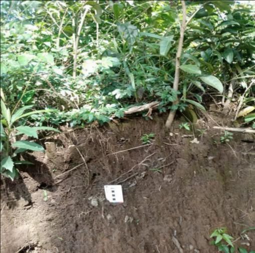
Advance Journal of Agriculture and Ecology
 Adv. J. Agric. & Eco.
 Volume: 4; Issue: 02
 March-April, 2021
 ISSN 2334-2414
 E-ISSN 2344-2492
 Impact Factor: 2.149
 Advance Scholars Publication
 Published by International Institute of Advance Scholars Development
 http://iiasdpub.co.uk/ajae/

Serra da Meruoca, a humid residual mountain that in literature is defined as a humid enclave and despite being in the
northeastern semiarid, it is remarkable by presenting a set of natural elements that differ from others geo-environmental units
that make up a parcel of the Northwest region in Ceará. Such understanding can be attested in Souza and Oliveira’s
judgements (2006) who expressed that such areas considered as humid and sub-humid enclaves are spread in a dispersed way
in semiarid outback and are configured as truly exception subspaces. Despite offering good conditions to ease the climate, to
preserve forests, and in agricultural sector, these areas display strong limitations and fragilities, that according to Arruda (2001)
the reason for this is the relief arrangement, which has pretty sharp slopes, as well as its soil impermeability. By understanding
that pedology is a science which studies the soil formation and was started in Russia by Dokuchaev in 1980, studies related to
soil have become quite relevant to other sciences. However, as a dynamic natural resource, soil is liable to be degraded in
function of improper use by humans, condition in which the performance of its basic functions are seriously damaged, what
carries negative interferences in environmental balance, reducing quality of life in ecosystems, mainly in those that suffer more
directly this human interference like urban and agricultural systems.
According to Brazilian Agricultural Research Corporation – Embrapa (2006), soil is a collection of natural bodies composed by
solid, liquid and gaseous part, tridimensional, dynamic, made up of organic and mineral materials, occupying most part of the
superficial mantle of continental extensions. Yet, in relation to this topic, Jenny (1941) mentions that soil is result of the
interaction among five environmental factors, namely: material of origin, climate, relief, organisms and time. Hence, Lepsch
(2010, p.19) reinforce when pronouncing that “soil is a collection of natural and dynamic bodies, which keeps matter alive, and
results from the climate and organisms’ action over a material of origin and the transformation in soil is realized during a certain
time and influenced by the kind of relief”. Obviously, the production of food and many others practices would not be possible
without these soils. About its complexity, the definition of soil differs in function of its purpose in several area of science.
Furthermore, its is verified that all definitions aimed to soil present in common the soil as an organism endowed with chemical,
physical and biological diversities and are basis to a vegetal formation and life on Earth. In general rules, it is relevant to argue
that soil is a natural element, primordial basis to agriculture and stage for human activities. It is an important resource by good
productivities in agribusiness, by keeping a good quality of environment and, consequently, plants, animals and human beings’
sanity. Face to these facts, this research aims to make some considerations about a pedological and environmental
characterization of two categories of soil, fluvic neosol and red yellow acrisol, both located in Meruoca Sierra, being this place
the spatial clipping to this work.
Materials and Methods Area Location and Characterization
The methodology employed in this research is based on a two stages premise: desk and field. The desk stage is constituted at
first by bibliographic systematization like specific readings, supported by a systemic analysis grounded on the Systems General
Theory of Bertalanffy (1975) as a support to understand pedological and environmental characterization just as soil factors and
its relation to other natural compounds, and to the local landscape. In addition, other works that discuss this same topic were
considered. In the field stage, activities were carried out to observe and verify pedological and environmental characterization
[Type here]

                                                      LIMA PEREIRA

                                                                  2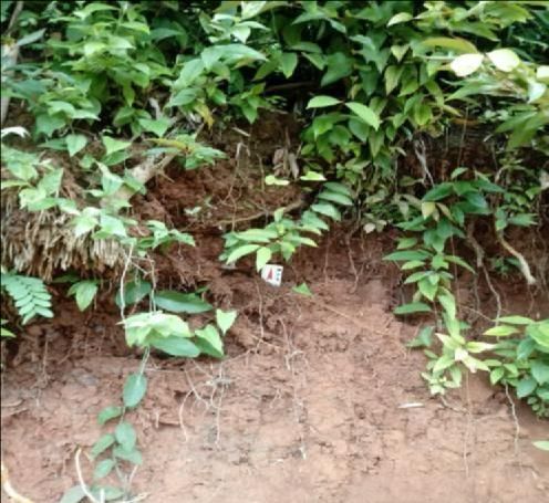
Advance Journal of Agriculture and Ecology
Adv. J. Agric. & Eco.
Volume: 4; Issue: 02
March-April, 2021
ISSN 2334-2414
E-ISSN 2344-2492
Impact Factor: 2.149
Advance Scholars Publication
Published by International Institute of Advance Scholars Development
http://iiasdpub.co.uk/ajae/
specific from the area, like cartographical data collection which subsidized the confection of a local map and photographic
records of selected soils to be studied. When it comes to a pedological context, there is a characterization of soils, where it is
possible to find the following types:Oxisol, Luvisol,
Neosol, Acrisol (fluvic, litholic and quartzeneic). It wasexaminedthe Reconhecimento de Solos do Estado do Ceará,
MA/DNPEA-SUDENE/DRN (Ceará SoilRecognition) (1973) classified as EMBRAPA SOLOS(Embrapa
Soils)(2006).
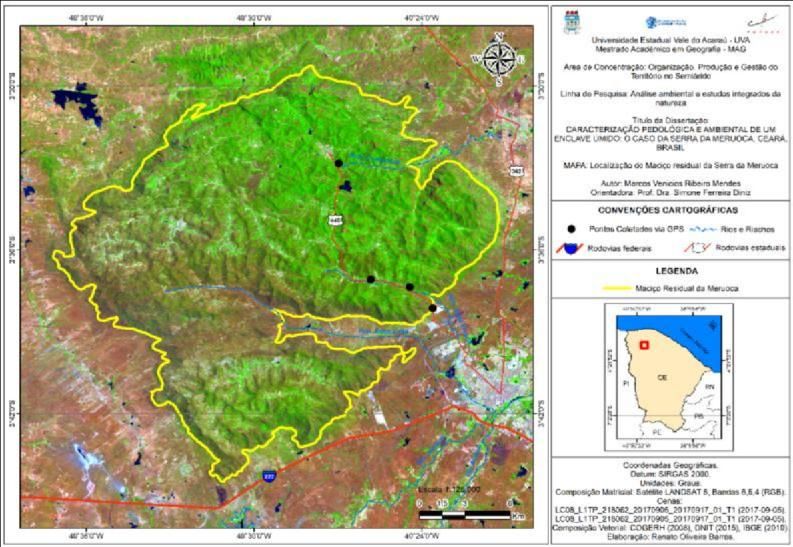
In a spatial context, Meruoca/CE (Map 01) is a Brazilian municipality in Ceará and is located in the Northwest of it. Its 260
kilometers far from the capital, Fortaleza, having the highway BR-222 as an access form.
Regarding to its cartographical location, it is positioned in the geographical coordinates 3°32’ 30” Latitude (S) e Longitude (W)
40º 27' 18". The municipalities in its boundaries are: to the North, Massapê, to the South, Sobral, to the East, Massapê and to
the West, Alcântara (IPECE, 2017). Yet, in relation to this area, it has a rectangular shape measuring between 20 and 25 km
(SOUZA, 1988). Below it is possible to see a figure representing Meruoca Sierra, our area of study.
Source: BARROS; MENDES (2019)
Marcos Venicios Ribeiro Mendes & Simone Ferreira Diniz 193
In geomorphologic terms, Meruoca Sierra is framed inside the geo-environmental unit of residualmountains. To Souza et
al(1979) this residual mountains cover residual reliefs originated from erosive processes which occurred in the Cenozoic
Era, when happened a great modification and modelling in the northeastern relief and the pediplain was eroded until it
become an outback depression.Furthermore, Souza and Oliveira (2006) report that geological structure is formed by a
[Type here]
LIMA PEREIRA
3
Advance Journal of Agriculture and Ecology
 Adv. J. Agric. & Eco.
 Volume: 4; Issue: 02
 March-April, 2021
 ISSN 2334-2414
 E-ISSN 2344-2492
 Impact Factor: 2.149
 Advance Scholars Publication
 Published by International Institute of Advance Scholars Development
 http://iiasdpub.co.uk/ajae/

   granitic stock named ComplexoGranítico Serra da Meruoca (Meruoca Sierra Granitic Complex) which includes the unit of
    granites Meruoca, Mucambo and Serra da Barriga from the Cambrian period, constituted by lightpinkish and reddish
granites. In what concerns the climate, it express conditions like a region of azonal climate in connection with tropical and
  subtropical belts (AB’ SABER, 1974). Precipitation is regular, registering precipitation level over 1000 mm per year. To
      Souza (2000), humid sierras represent woodland enclaves, where rainfall index is strongly meaningful, the average
  precipitation usually ranges from 1.000 to 1.500 per year. In this respect, Fernandes (1990), affirms that in humid sierras
  from 600-700m of altitude, it prevails an evergreen or sub-evergreen hydrophilic forest vegetation, included in the type
     pluvial of altitude which is an essential indicative of environments with a great floristic and pedological potential in
                                                             landscape.
In pedological aspects, there is soil characterization, where the following types were found: Oxisol, Luvisol, Neosol, Acrisol
(fluvic, litholic and quartzeneic), though, Neosol and RedYellow Acrisol were prioritized in this study since they are the most
representative in Serra da Meruoca. In addition to this, diversity/potential takes place during deep or very deep soil formation,
with potential to agricultural activities which in general are subject to a semiarid climate, and rarely to humid and subhumid
climates. It is worth mentioning that for the reason of being ingrown in residual mountains category, Souza (2000) points that
these areas have been suffering, along the years, many types of use of natural resources, above all those directed to the
agricultural sector in view of its natural potential. Admittedly, degradation in the semiarid environment, such as in humid
enclaves, is outstanding the presence of degradation as a result of historic expansion in agricultural boundaries and vegetal
extraction (LIMA et al, 2000). About such thinking, Costa Falcão (2002, p. 01) mentions that “humid residual mountains in the
Northeast has been put traditionally as the most meaningful agricultural sector”. Regarding to it, agriculture developed in these
areas is relevant to the semiarid outback as it is possible to realize in Ab’Saber’s discussion (1999) when he comes to present
the dry Northeast.
Results and Discussions
In relation to soil types which correspond to the studied area were identified through office works, field works, photographic
records, following the classification of Sistema Brasileiro de Classificação de Solos (Brazilian Soil Classification System)(SIBCS,
2006) which was extremely important to the area characterization. In this perspective, it was observed the following soil types:
Oxisol, Luvisol, Neosol, Acrisol (fluvic, litholic and quartzeneic). Still in this respect, Lima (2007) shows that the diversity in
the types of soil is caused by some factors, mainly the climate and matrix rock. For this study, it was favoredFluvic Neosol and
Red Yellow Acrisol, which are used for a wide range of cropping such as: corn, beans, manioc, fruitful trees (banana, mango,
coconut trees amongst others), as well as babassu density which occupies several compartments in this sierra. In addition, soil
is strongly essential to farmers in Meruoca Sierra, people who lives the reality of agriculture, what has become the principal
source of income and a way of appropriation of man before nature. As previously highlighted, this research made possible to
see some soil types, though, only two among them were prioritized and listed below.

[Type here]

                                                     LIMA PEREIRA

                                                                4
Advance Journal of Agriculture and Ecology
Adv. J. Agric. & Eco.
Volume: 4; Issue: 02
March-April, 2021
ISSN 2334-2414
E-ISSN 2344-2492
Impact Factor: 2.149
Advance Scholars Publication
Published by International Institute of Advance Scholars Development
http://iiasdpub.co.uk/ajae/
FLUVIC NEOSOL
It is a type derivated from alluvial sediments with horizon A over horizon C constituted by stratified layers. One of its
characteristics is the high natural fertility, directed to agricultural uses, and frequently used to practices of irrigation systems
(PEREIRA; SILVA 2005). They are developed from fresh and stratified alluvial sediments in a way that layers do not have a
pedogenetic relation among themselves.Besides, such soil type prevails in lowland areas occupying marginal watercourses and
made of non-strengthened sediments – clay, silt, sand – originated from quaternary fluvial deposits (PEREIRA; SILVA 2005).
As a complement, Diniz (2010) affirms the fluvic neosol is a soil with horizons A weak and the sequence of horizons A-C,
overly drained, strongly acidic, low level of clay (under 15%), color ranging between red and white, or even yellowish. Due to
its fertility and a plane relief this soil is used to agricultural practices in the semiarid environment, outstanding the agriculture
for a living. Related to its potential and limitations, in function of the heterogeneity of chemical and physical properties, this
soil can be of a high, medium or low agricultural potential, depending of restrictive factors which it might present
itself.(EMBRAPA, 2006). The principal restrictions of this soil are the risk of flood, low natural fertility, excess of humidity
due to the presence of groundwater so close to the surface and the difficulty in automated handling when it presents a very
thin texture.
When there is a medium texture and a good drainage, it offers a high potential to the implementation of agribusiness
(EMBRAPA, 2006). As for agricultural practices in this type of soil, Falcão Sobrinho et al (2017, p.75) “describes that these
agricultural practices are generalized in the area, even in a significant declivity relief”. However, this type of soil is also considered
as a great agricultural potential.
Figure 01: Neosol profile.
[Type here]
LIMA PEREIRA
5Advance Journal of Agriculture and Ecology
Adv. J. Agric. & Eco.
Volume: 4; Issue: 02
March-April, 2021
ISSN 2334-2414
E-ISSN 2344-2492
Impact Factor: 2.149
Advance Scholars Publication
Published by International Institute of Advance Scholars Development
http://iiasdpub.co.uk/ajae/
Source: MENDES (2019)
Red Yellow Acrisol
Red Yellow Acrisol is the type of soil with the biggest extension in Meruoca Sierra, it presents a variable deepness, from
strongly to imperfectly drained, presenting a yellow or red color, and rarely, bronze or gray. Texture ranges from sandy to
clayey in horizon A and in average is pretty loamy in horizon Bt […] (EMBRAPA, 2006, p.91). This type of soil presents a
clear increment in clay level from the superficial horizon to horizon B, with or without a decrease to the profile bottom.
Therefore, the transition of horizons A and Bt is usually clear, abrupt or progressive. In regarding to this apparent
characteristic, Diniz (2010) reinforce when he declared that Red Yellow Acrisol is a nonhydromorphic mineral with horizons
A or E contiguous to the textural B without plinthite, high or low clay activities and iron level under 11%. The main
morphologic characteristic of Acrisol is the presence of a textural horizon B below a horizon A or E. About its deepness, it
varies from strongly to imperfectly drained, being reddish or yellowish, and rarely, grayish or with a bronze color. Yet, in the
area of study this type of soil is also used in small brickyards to make bricks and ceramic artifacts. In terms of potential and
limitation, this soil shows a low natural fertility, presenting as principal restriction that occurs in environments with busy relief,
related to crystalline rocky environments (EMBRAPA, 2006). For Falcão Sobrinho et al,(2017, p.75), “agricultural practices in
this type of soil, is usually related to the daily life in communities, where agricultural production is strong”. It is worth
highlighting that handling is an instigator due to the use and occupation of the soil. Below is a picture of a Red Yellow Acrisol.
Figure 02: Acrisol profile.
[Type here]
LIMA PEREIRA
6Advance Journal of Agriculture and Ecology
Adv. J. Agric. & Eco.
Volume: 4; Issue: 02
March-April, 2021
ISSN 2334-2414
E-ISSN 2344-2492
Impact Factor: 2.149
Advance Scholars Publication
Published by International Institute of Advance Scholars Development
http://iiasdpub.co.uk/ajae/
Source: MENDES (2019)
Final Considerations
Before such observed information, it was possible to realize that pedological studies are relevant to understand landscapes and
agricultural production, as well as a resource to carry out territorial planning. It is important to mention that the integrated
analysis of local landscape made possible the comprehension of spatial modification and the origin of soils by relating
geomorphological, climatic, geological aspects besides uses and occupation, compounds which act together contributing not
only to pedogenetic processes but also to erosive processes. It is necessary to stress that agriculture has always been present in
humid enclave in Meruoca Sierra, reason which caused modification in the local landscape, raising environmental problems
such as moderated dissection processes in the relief, contributing to soil erosion. The loss of such soils through erosion have
been boosted by agricultural practices, carried out in improper ways by farmers who desire to have a good agricultural
development.
Acknowledgement
To FUNCAP and to Geography Academic Master Program at UniversidadeEstadual Vale do Acaraú – CE-
MAG/UVA.
Bibliographical References
AB'SÁBER, A.N. Morphoclimatic Semiarid Domainof Brazilian Caatingas. Geomorphology, n. 43. IG – USP. São Paulo, 1974.
______OutbackandOutback People: a human suffere dgeography. Estudos Avançados Magazine, São Paulo, v.13 n 36, p 7-
59,1999.
[Type here]
LIMA PEREIRA
7Advance Journal of Agriculture and Ecology
Adv. J. Agric. & Eco.
Volume: 4; Issue: 02
March-April, 2021
ISSN 2334-2414
E-ISSN 2344-2492
Impact Factor: 2.149
Advance Scholars Publication
Published by International Institute of Advance Scholars Development
http://iiasdpub.co.uk/ajae/
______Nature Domainsin Brazil: landscape potential. São Paulo, SP: Ateliê Editorial, 2003.
ARRUDA, L. V.Maranguape Sierra – CE: Eco dynamic in landscape and Socio environmental Implications. Fortaleza, UFC,
2001. 162 p. Thesis (Masterin DevelopmentandEnvironment). PRODEMA. Universidade Federal do Ceará, 2001.
BERTALANFFY, L.General System Theory. 2 ed. Petrópolis: Voices, 1975.
COSTA FALCÃO, Cleire Lima da. Preliminary Evaluation of Erosion Effects and Management Systems in the Productivity of
Acrisol in Meruoca Sierra. Master Thesis – UFC, Fortaleza, 2002.
DINIZ, S. F.Physiographic characterizationand pedologyin the North regionin theStateof Ceará. (PhD Thesis). Universidade
Estadual Paulista, Rio Claro, 2010.
EMBRAPA. NationalSoilResearch Center. Brazilian Systemof Soil Classification.2ª edition, Rio de Janeiro-RJ, 2006.
FERNANDES, Afrânio.PhyitogeographicsTopics. Fortaleza: Stylos Communication, 1990.
FALCÃO SOBRINHO, J.; COSTA FALCÃO, C. L.; MENDES, M. V. R.; PAIVA, A. M.
IntegrationofGeomorphologic e PedologicElementsin Boqueirão (Sobral, CE). XVII Brazilian Symposiumof Physical
Applied Geography I Physical Geography National Conference. The challengesinPhysical Geographyin the
knowledgeboundaries. Geoscience Institute – Unicamp, Campinas- SP 28 de Junho a 02 de Julho de 2017. P. 71-77.
IPECE, InstituteofResearchand Economical Strategy of Ceará. Fortaleza. 2017.
JENNY, H. Factors of Soil Formation: A System of Quantitative Pedology. New York, Dover Publications, 1941. 281p.
LIMA, L. C.; SOUZA, M. J. N.; MORAIS, J. O. Territorial Subdivision and Regional Management of Ceará. Fortaleza:
FUNECE, 2000. 268p.
LIMA, E. C. GeoambientalAnalysisof Vale do Riacho Boqueirão – Sobral/CE. Homem, Tempo e Espaço Magazine. Sobral
(CE), September, 2007.
LESPCH. I. F.SoilFormationandConservation. Ed. Oficina de Textos, São Paulo, 2010.
PEREIRA, R. C. M; SILVA, E. V. CearáSoilandVegetation: General Characteristics. In: SILVA, J. B.; DANTAS, E. W.;
CAVALCANTE, T. Ceará: A New GeographicalView. Fortaleza: Demócrito RochaEdition, 2005.
SUDENE. Exploratory Survey–Ceará Soils Recognition. vol. I e II. Recife: Soil Mapping Partnership MA/DNPEA –
SUDENE/ DRN, 1973.
SOUZA. M.J. N; LIMA, F.A.M; PAIVA, J,B.CearáTopographicSubdivision, Fortaleza, 1979.
______Contributionto CearáMorphostructural Units Studies. Rev. de Geology v.1, ed. UFC. Fortaleza, p.73-91. 1988.
______CearáNatural Basis and Geoenvironmental Zoning Sketch. In: SOUZA, MORAES, J. O.; LIMA, L.C.Ceará Territorial
subdivisionandRegional Management, Part I. Fortaleza: FUNECE, 2000. 28-31p.
______OLIVEIRA, Vládia Pinto Vidal de. Humid and Subhumid Enclaves in the Brazilian Semiarid Northeast.
Mercator – UFC Geography Magazine, year 05, number 09, 2006
[Type here]
LIMA PEREIRA
8You can also read