A proposed framework for managing river flows to support implementation of the NPS-FM - Prepared for Ministry for the Environment July 2022
←
→
Page content transcription
If your browser does not render page correctly, please read the page content below
A proposed framework for
managing river flows to support
implementation of the NPS-FM

     Prepared for Ministry for the Environment

                    July 2022
Prepared by:
Doug Booker, Paul Franklin, Rick Stoffels

For any information regarding this report please contact:
Doug Booker
Hydro-ecological modeller
Freshwater modelling
+64-3-343 7848
doug.booker@niwa.co.nz

National Institute of Water & Atmospheric Research Ltd
PO Box 8602
Riccarton
Christchurch 8011
Phone +64 3 348 8987

If you have any feedback or questions about the NPS-FM 2020, please email the Ministry for the
Environment at freshwater@mfe.govt.nz

NIWA CLIENT REPORT No:      2022130CH
Report date:                July 2022
NIWA Project:               MFE22505

 Revision                               Description                              Date

 Version 1.0                            Draft Report for external review         1 June 2022

 Version 1.1                            Revised Report for review                28 June 2022

 Version 1.2                            Final Report                             14 July 2022

 Quality Assurance Statement

                                      Reviewed by:                              Neale Hudson

                                      Formatting checked by:                    Rachel Wright

                                      Approved for release by:                  Scott Larned

© All rights reserved. This publication may not be reproduced or copied in any form without the permission of
the copyright owner(s). Such permission is only to be given in accordance with the terms of the client’s contract
with NIWA. This copyright extends to all forms of copying and any storage of material in any kind of
information retrieval system.

Whilst NIWA has used all reasonable endeavours to ensure that the information contained in this document is
accurate, NIWA does not give any express or implied warranty as to the completeness of the information
contained herein, or that it will be suitable for any purpose(s) other than those specifically contemplated
during the Project or agreed by NIWA and the Client.
Contents
Executive summary ............................................................................................................. 5

1       Introduction .............................................................................................................. 8
        1.1      Purpose ..................................................................................................................... 8
        1.2      Aim ............................................................................................................................ 8
        1.3      Scope......................................................................................................................... 8
        1.4      Positioning ................................................................................................................ 9
        1.5      Structure ................................................................................................................... 9
        1.6      Content ................................................................................................................... 10

2       Fundamental principles for river flow management .................................................. 11
        2.1      Physical and ecological states influenced by river flows ........................................ 11
        2.2      Flow-driven metrics for ecosystem health ............................................................. 13
        2.3      River flow regimes .................................................................................................. 13
        2.4      Hydrological indices ................................................................................................ 14
        2.5      Calculating and interpreting hydrological indices .................................................. 16
        2.6      Choosing hydrological indices to inform river flow management .......................... 19
        2.7      Hydrological models and maps ............................................................................... 21
        2.8      Hydrological classifications ..................................................................................... 23
        2.9      Flow regime alteration............................................................................................ 24
        2.10 Estimating naturalised flows................................................................................... 26

3       Delivering river flow management ........................................................................... 29
        3.1      Broad definitions of environmental flow regimes .................................................. 29
        3.2      Approaches for setting environmental flow regimes ............................................. 31
        3.3      Spatial variation in environmental flow regimes .................................................... 32
        3.4      A proposed framework for delivering environmental flow regimes ...................... 33

4       The NPS-FM with respect to river flow management ................................................ 37
        4.1      Why do river flows need to be managed under the NPS-FM? ............................... 37
        4.2      Interpretation of Environmental flows and Take limits in the NPS-FM 2020......... 41
        4.3      Relating NPS-FM clauses to river flow management.............................................. 42

5       Summary and recommendations .............................................................................. 51

6       Acknowledgements ................................................................................................. 52

A proposed framework for managing river flows to support implementation of the NPS-FM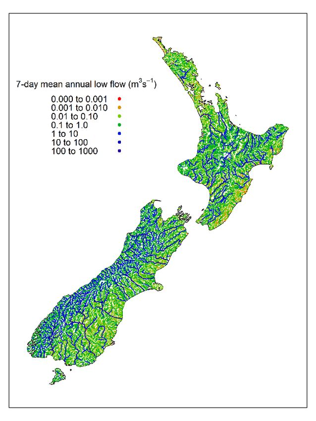
7     References............................................................................................................... 52

Tables
Table 2-1:         Examples of hydrological indices (after Richter et al., 1997).             15
Table 2-2:         Hypothetical examples of links between in-stream values and hydrological
                   indices.                                                                   20
Table 2-3:         Potential causes of river flow alteration.                                 25
Table 4-1:         Reasons why river flows are a necessary consideration for each of 15 NPS-FM
                   2020 policies.                                                             37
Table 4-2:         Values from NPS-FM 2020 Appendices, and how they could relate to river
                   flows.                                                                     40
Table 4-3:         The description of “take limit” quoted from the 2020 NPS-FM.               41
Table 4-4:         Implications for river flow management from several NPS-FM 2020 clauses,
                   and where these fit into the proposed river flow management framework. 43
Table 4-5:         Label, purpose, and hypothetical examples of steps in the proposed framework
                   for river flow management.                                                 47

Figures
Figure 1-1:        Simplified depiction of a proposed framework for river flow management.       6
Figure 2-1:        PCA ordination of 25 hydrological indices, using daily flow records from 438
                   river gauging stations distributed across New Zealand.                       18
Figure 2-2.        Maps of estimated hydrological conditions after Booker (2013) and Booker and
                   Woods (2014).                                                                22
Figure 2-3:        Map of accumulated upstream consented takes relative to estimated median
                   flow following the methods of Booker (2018).                                 28
Figure 3-1:        Hydrographs (top) and February flow duration curves (bottom) together with
                   hypothetically proposed environmental flow regimes and altered river flows
                   for two example rivers.                                                      30
Figure 3-2:        A proposed framework for river flow management comprising a cascade of
                   steps.                                                                       35

                       A proposed framework for managing river flows to support implementation of the NPS-FM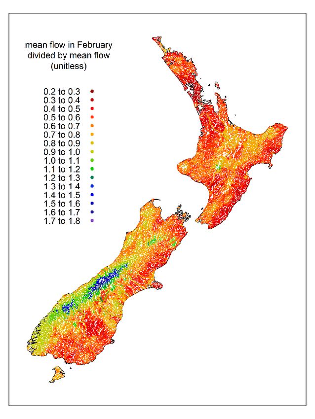
Executive summary
River flows are a master variable that are linked to various physical, chemical, and ecological states
that are in-turn linked to ecosystem health, human health, cultural wellbeing, landscape character,
recreation, and water supply for out-of-stream use. Local authorities must prepare regional plans
and action plans that give effect to the National Policy Statement for Freshwater Management 2020
(NPS-FM). River flows are an essential and legitimate consideration for all 15 NPS-FM policies and
many of the values described in NPS-FM Appendix 1. The NPS-FM Te Mana o te Wai hierarchy of
obligations prioritises first the health and well-being of water bodies and freshwater ecosystems,
second health needs of people, and third the ability of people and communities to provide for their
social, economic, and cultural well-being. The Te Mana o te Wai hierarchy of obligations is relevant to
all freshwater management, including river flow management.
Two of the most important technical terms relating to river flow management within the NPS-FM are
“environmental flows and levels” and “take limits”. The NPS-FM does not define environmental
flows, but the take limit interpretation is “a limit on the amount of water that can be taken from an
FMU or part of an FMU, as set under clause 3.17”. In this report, we interpret the terms as follows:
▪ Environmental flows describe the aspirational state of river flow regimes required to
achieve the environmental outcomes described in the NPS-FM. Environmental flows
should be thought of as environmental flow regimes that describe the main features of
a long-term river flow time-series required to achieve environmental outcomes.
Environmental levels are the equivalent to environmental flows, but environmental
levels apply to water levels in aquifers (groundwater levels), lakes and wetlands.
▪ Take limits are sets of rules in regional plans that constrain water use to restrict the
degree of hydrological alteration arising from collective operation of flow-altering
activities. Take limits can be thought of as predefined rules that guide authorities to
deliver environmental flows by controlling flow-altering activities. Take limits also
clarify water availability for out-of-stream use.
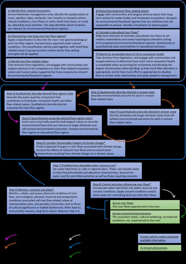
We propose a framework that can be used to facilitate an approach to managing river flows to
achieve environmental outcomes defined under the NPS-FM (Figure 1-1; See Figure 3-2 on page 35
for full version). The framework sets out a transparent approach for linking environmental flow
regimes to ecosystem states that represent ecosystem health through controls on flow-altering
activities. The framework comprises a cascade of steps which:
▪ starts with a broad definition of environmental flow regimes;
▪ includes consideration of climate change;
▪ incorporates a loop for monitoring and adaptive management; and
▪ ends with controls on flow-altering activities.
We demonstrate how this framework can be operated in a manner consistent with the NPS-FM by
mapping each flow-related NPS-FM clause to a step in the framework.
A proposed framework for managing river flows to support implementation of the NPS-FM 5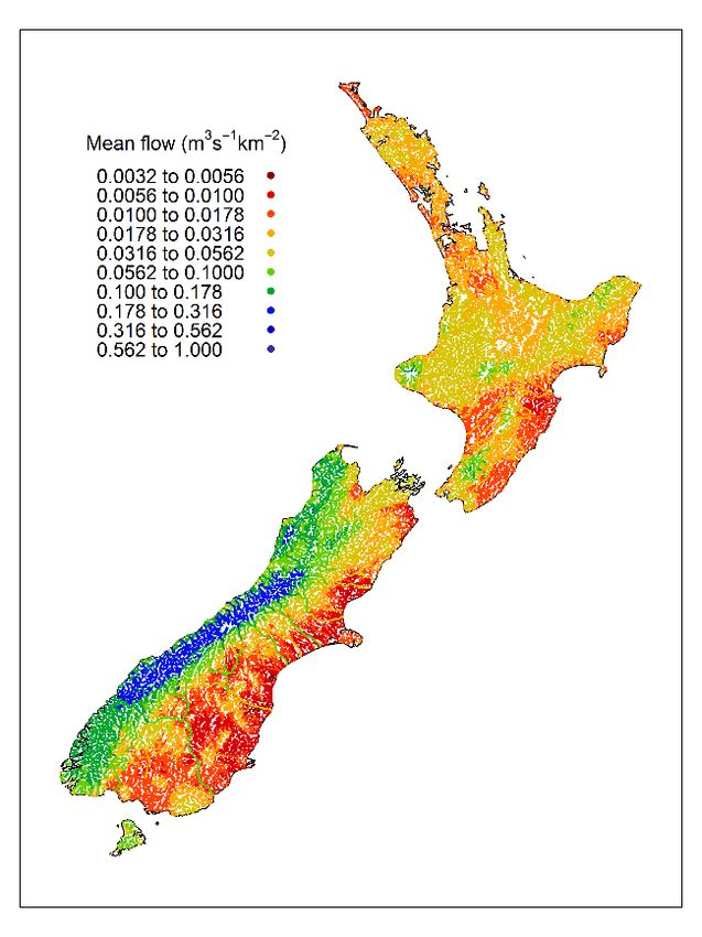
Figure 1-1: Simplified depiction of a proposed framework for river flow management. See Figure 3-2 on
page 35 for full version including descriptions of each step.

The foundational principles behind this framework are summarised in the following points.

         1.   There is a strong theoretical basis for links between river flow characteristics and the
              freshwater environments, ecological functions, and ecosystem values they support.
              Aspects of ecosystem health (including periphyton, benthic invertebrates and fish
              communities) are linked with aspects of river flow. Flow-ecology relationships are
              therefore often needed to inform river flow management decisions. However,
              development of quantitative flow-ecology relationships is hampered by lack of data,
              confounding effects of non-flow stressors, and natural variability through time.
              Furthermore, flow-ecology relationships are likely to vary spatially due to landscape-
              scale differences in climate-hydrology-geomorphology-ecology.

         2.   River flow regimes are multifaceted characterisations of the main features of a river
              flow time-series when viewed over the long-term. River flow regimes vary naturally
              across the landscape because of differences in climate, geology, soil properties and
              vegetation cover. Features typically used to characterise flow regimes include the
              magnitude and duration of low flows, magnitude and frequency of medium and high
              flows, and degree of seasonality.

         3.   Sets of many hydrological indices have been proposed to represent various features of
              river flow regimes and also to describe environmental flow regimes. Knowledge about
              how a single hydrological index fits within the wider flow regime is required to avoid
              unintended outcomes for river flow management. Each individual index represents a
              particular characteristic of the regime, such as drought duration, flood magnitude, or

6                  A proposed framework for managing river flows to support implementation of the NPS-FM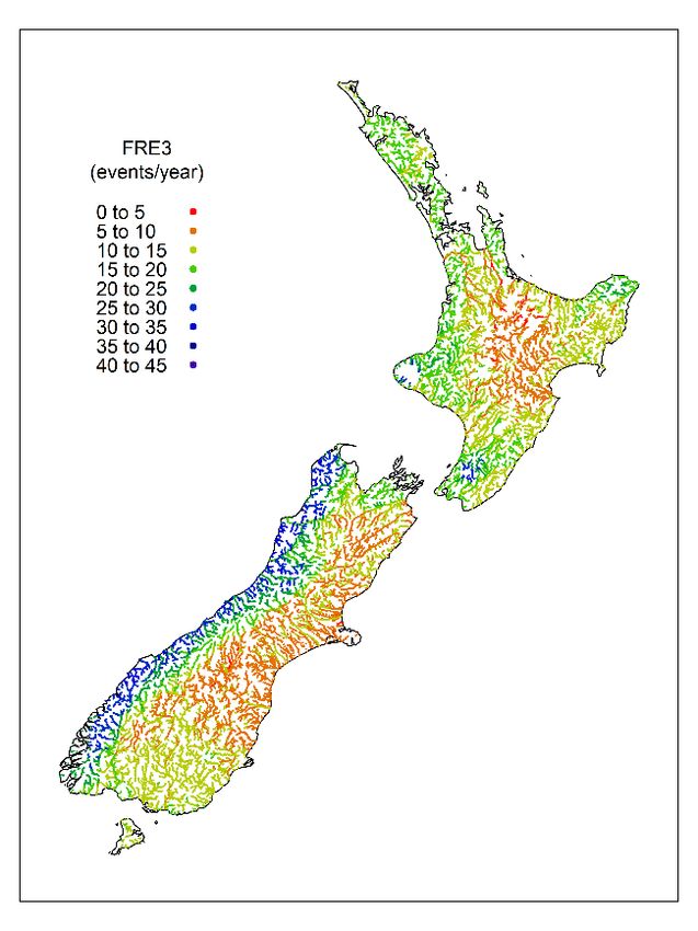
seasonality. Hydrological indices have been associated with geomorphological
              conditions, ecosystem processes, or water availability. For example, habitat conditions
              at low flows are commonly associated with mean annual low flow (MALF) and flushing
              flows associated with frequency of events that exceeds three times the median flow
              (FRE3). Because they are often related to each other, several hydrological indices may
              also correlate with an ecological metric. Although statistical redundancy occurs when
              hydrological indices are correlated, this does not necessarily equate to functional
              redundancy between hydrological indices with respect to links to in-stream values.

         4.   River flow regimes vary widely across Aotearoa-New Zealand. Expected spatial
              patterns under reasonably natural conditions can be represented as hydrological
              classifications or maps of predicted hydrological indices. However, currently available
              classifications of New Zealand’s river network were not specifically designed to set
              environmental flows or take limits across FMUs and are yet to be tested for these
              purposes.

         5.   River flow regimes can be altered by a complex and interrelated combination of local
              human activities and climate change. River flow regimes can be altered directly by
              engineered manipulation of groundwater or surface water (e.g., abstraction, diversion,
              damming). River flow regimes can also be altered indirectly when water fluxes are
              modified by any combination of the following:

              ▪    drainage modification (e.g., tile drainage, drainage ditches);

              ▪    river channel modification (e.g., channel straightening);

              ▪    urbanisation (e.g., increased impermeable surfaces);

              ▪    intentional changes in landcover (e.g., deforestation or afforestation);

              ▪    unintentional shifts in landcover (e.g., invasive vegetation such as wilding pines,
                   climate-driven change in tree line);

              ▪    primary physical effects of climate change (e.g., reduced precipitation); and

              ▪    climate-driven changes in water demand (e.g., irrigation).

         6.   Approaches to setting environmental flow regimes range from specifying a default
              allowable deviation from natural flow regimes to evidence-based design of flow
              components to meet the needs of specified in-stream values. The appropriateness of
              any environmental flow setting approach will depend on data availability, degree of
              hydrological alteration, and type of in-stream value.

         7.   Environmental flows and take limits should be considered as spatially distributed
              phenomena, rather than applying to single sites. Environmental flows must account for
              spatial variations in in-stream values and flow-ecology relationships. Flow alteration
              will vary in space due to cumulative effects and the connected hierarchical nature of
              river networks. The number, spatial configuration, and strategy for implementing
              water takes to meet environmental flows and take limits is therefore important for
              delivering environmental outcomes across a Freshwater Management Unit (FMU). If
              spatial considerations are ignored, some implementation strategies could ensure that
              take limits are met at a downstream monitoring point, but not complied with
              elsewhere across an FMU.

A proposed framework for managing river flows to support implementation of the NPS-FM                    7
1       Introduction
1.1     Purpose
This report provides information about the National Policy Statement for Freshwater Management
2020 (NPS-FM). It is not part of the NPS-FM 2020 and it does not have statutory weight. The primary
purpose of this report is to help regional councils understand and effectively implement the
objectives and policies in the NPS-FM 2020 that pertain to management of river flows to support
ecosystem health. This report may also be of use to tangata whenua, stakeholders, or community
members who are participating in a regional freshwater planning process.

1.2     Aim
The aim of this report is to set out foundational principles and a general framework to facilitate a
credible approach to managing river flows to sustain ecosystem health in a manner that is consistent
with the NPS-FM. Examples of technical methods are mentioned. However, a comprehensive set of
prescriptive instructions is not provided. Provision of a general framework, rather than prescriptive
instructions for technical methodologies, is consistent with the NPS-FM because the NPS-FM allows
for flexibility in the methods used to give effect to its objectives and policies. Allowance for flexibility
is appropriate given regional/catchment variability in climate, topography, geology, ecology, demand
for water use, data availability, and values proposed by tangata whenua and communities. Flexibility
in technical methods is also appropriate because improvements in knowledge, monitoring and
models should occur over time. Indeed, the NPS-FM (Clause 1.6) recognises that complete and
scientifically robust data are not currently in place to adequately meet all the needs of the NPS-FM in
all locations. In the absence of complete and scientifically robust data, the best information may
include that obtained from modelling, as well as partial data, local knowledge, and information
obtained from other sources. One role of a general framework is to help highlight scientific
advancements needed to give effect to the NPS-FM (e.g., monitoring data, knowledge, and
modelling).

1.3     Scope
This report concentrates on management of river flows in support of flow-driven in-stream values
relating to ecosystem health. Human activities influencing hydrological conditions in aquifers are in
scope because there can be strong interconnections between groundwater manipulation and river
flows. The scope of this report is confined to river environments including river mouth openings,
estuaries and hāpua. It is recognised that hydrological conditions influence physical, chemical and
ecological states in wetlands, lakes and aquifers. Although wetlands, lakes and aquifers are not
considered explicitly here, recommendations for river flow management provided here can be
adapted for application to these environments.

It is likely that many flow-driven aspects of cultural, recreational, and aesthetic values are
intertwined with ecosystem health (e.g., Harmsworth et al., 2011). We acknowledge that in-stream
values associated with cultural, recreational, or aesthetic perspectives are important for river flow
management but are not considered explicitly in this report. With respect to cultural values, we refer
to Crow et al. (2018) who indicated the importance of cultural flow assessments being “undertaken
by mandated representatives of the hapū or iwi, who have a history of interacting with the wetlands,
streams and rivers within their rohe.” This is important because Crow et al., (2018) also stated that:
“From the perspective of Māori cultural values, beliefs and practices supported by fresh water can be
seen to compete with these economic uses [irrigation and hydroelectric generation]. If the interests
of Māori are to be weighed alongside the many other uses, and if environmental streamflow

8                   A proposed framework for managing river flows to support implementation of the NPS-FM
assessments and allocative decision-making are to benefit from the knowledge of whanau, hapū and
iwi, new techniques are needed to assess the appropriateness of streamflows in culturally sensitive
ways”. This need is clearly identified within the NPS-FM because it recognises the importance of
identifying tangata whenua values that collectively recognise the significance of fresh water. We
refer readers to the work of Harmsworth et al. (2016), Tipa et al. (2016), Ataria et al. (2018), Clapcott
et al. (2018), Morgan et al. (2021), Taylor et al. (2021), Tadaki et al. (2022) and others on cultural
aspects of freshwater management that link to the right to exercise kawanatanga (governance) in a
manner consistent with the principle of partnership, and the duty to protect rangatiratanga
(sovereignty) in relation to taonga katoa (treasures) as these important issues are not dealt with here
because they are outside the scope of this report.

Freshwater accounting systems are required by the NPS-FM. However, technical methods for
producing water accounts are not in scope for this report. We assume that accounting systems will
provide baseline information relevant to river flow management, including spatial patterns of the
take limit, and the amount of freshwater that is physically available, allocated, and taken regardless
of whether for consented, permitted, or other activities. We also assume that freshwater accounting
systems will provide observations or estimates of current and naturalised river flows and their
associated uncertainties. For freshwater accounting, naturalised river flows are defined as flows
estimated in the absence of “all takes and forms of water consumption, whether metered or not,
whether subject to a consent or not, and whether authorised or not” (as is consistent with NPS-FM
Clause 3.29).

At the time of writing, many regional councils are working towards establishing policies and
methods, including rules set in regional plans, by 2024 that will give effect to the NPS-FM. Many
councils may have already set rules under the previous NPS-FM 2014, however councils need to
review these rules and be confident that existing rules meet the requirements of the NPS-FM 2020,
including the fundamental concept of Te Mana o Te Wai. It is envisaged that this report can feed into
the development of plans because the framework we present can be used to demonstrate how
existing methods and processes are giving effect to flow management aspects of the NPS-FM. This
report is also intended to be of use beyond the 2024 deadline because general advice about
approaches to river flow management should endure beyond this date, and river flow management
should be seen as an on-going undertaking rather than a set and forget situation.

1.4     Positioning
This report was written independently from other guidance pertaining to the NPS-FM. We cannot
guarantee consistency between this report and other guidance or material relating to the NPS-FM.
This report should be viewed as an independent discussion paper from the authors because it was
not co-developed with the Ministry for the Environment (MfE), iwi partners or regional councils due
to a short timeframe for its production. This report does not constitute official guidance from MfE
and is not a substitute for legal advice. This report does not critique or suggest changes to the
published NPS-FM 2020, which we regarded as incontestable for the purposes of this report.

1.5     Structure
This report contains four main sections. The first section is this introduction. In the second section we
outline some fundamental principles for river flow management. Many of these principles will be
familiar to those involved in river flow management in New Zealand but are provided here for
completeness. In the third section we propose a framework for delivering a flow regime to fulfil
environment needs whilst allowing for some degree of hydrological alteration and thereby clarify
water availability after environmental needs have been met. The framework takes the form of a

A proposed framework for managing river flows to support implementation of the NPS-FM                   9
cascade of steps for linking a broad definition of environmental flow regimes through to methods for
controlling human activities that alter river flows. In the fourth section we provide our interpretation
of the requirements of the NPS-FM with respect to river flow management and describe where they
fit in the proposed framework. This fourth section also provides some suggested working definitions
of some technical terms used in the NPS-FM.

1.6     Content
The level of detail provided in Section Two reflects the complexity and difficulties inherent in river
flow management. Section Two draws on a wide body of local and international literature which
relates to river flow management. The literature on flow-ecology relationships is broad and complex.
We provide several references on flow-ecology relationships to help readers further explore the
topic. In the interest of brevity, only citations to the most pertinent scientific literature have been
included in all other sub-sections. Key points are provided at the start of each sub-section to
summarise the content.

The phrases “environmental flow regime” and “environmental flows” are often used, sometimes
interchangeably, in the international river flow management literature. In Section Two we use
“environmental flow regime” rather than “environmental flows” because the latter term has a
particular meaning within the NPS-FM which we then clarify in Section Three.

10                 A proposed framework for managing river flows to support implementation of the NPS-FM
2       Fundamental principles for river flow management
2.1     Physical and ecological states influenced by river flows
 Key points

           ▪    The integrity of freshwater systems depends on river flow to determine physical
                and ecological structure and processes.

           ▪    Multiple aspects of ecosystem health, including periphyton, benthic invertebrates
                and fish communities, are linked with various aspects of river flow.

           ▪    The specification of flow-ecology relationships is likely to vary spatially due to
                differences in a combination of climate, hydrology, geomorphology, and ecology.

River flow has been viewed as a “maestro” (Walker et al. 1995) or “master variable” (Power et al.
1995; Poff et al., 1997) with respect to riverine ecosystems because it influences all aspects of river
condition (Poff and Zimmerman 2010; Sofi et al., 2020). Various components of flow regimes
combine to control or influence channel structure, sediment delivery, hydraulic conditions,
disturbance regimes, food resources and water quality including nutrients, dissolved oxygen and
water temperature (Richter et al., 1997; Poff and Zimmerman 2010; Booker and Whitehead, 2022).
Ecological and evolutionary processes in river ecosystems are highly influenced by historical flow
regimes (Lytle and Poff 2004). In New Zealand, key aspects of stream ecology that are directly
influenced by river flows and river flow management include periphyton, benthic invertebrates and
fish communities (Biggs et al., 2008; Greenwood and Booker, 2015; Booker et al., 2016).

River flows interact with sediment supply, valley slope, valley confinement, and vegetation to drive
river geomorphological processes and set riverine habitat templates. Channel-forming high flow
events are often associated with transport of gravel and lateral bank erosion that influence meso-
scale geomorphological character (e.g., braided, pool-riffle, run, etc.) (Blom et al., 2017). Mid-range
and lower flows are often associated with transport and deposition of sand and fine sediment that
interact with ecological processes to influence micro-scale riverbed characteristics (e.g., bed texture,
interstitial spacing, hyporheic processes, etc.) (Wilkes et al., 2019). A variety of river flow magnitudes
and event return intervals are therefore important in determining river physical templates (Gurnell
et al., 2016) and overall river health (Maddock, 1999) at a range of spatial scales.

Periphyton is a complex mixture of algae, cyanobacteria, heterotrophic microbes and detritus that
attach to the riverbed. Most of New Zealand’s riverine food webs have periphyton as a basal energy
source, hence periphyton is critical to river ecosystem health. Periphyton species have specific
hydraulic (e.g., depth and velocity) preferences (Biggs, 1996). As a result, changes in the hydraulic
state of a river can impact periphyton species composition and biomass on a temporal scale of weeks
to months, and changes to flow regimes can affect periphyton species composition and biomass on a
scale of months to years (Biggs and Gerbeaux, 1993; Biggs and Hickey, 1994, Biggs et. al., 1999; Wu
et al., 2009). Periphyton-flow relationships are not spatially uniform due to variations in hydraulics,
sediment, nutrient availability, heat, and light (Hoyle et al., 2017).

Several aspects of flow regimes directly affect invertebrate diversity and abundance, which in turn
affect food supplies for fish, periphyton abundance and other ecosystem properties (Booker et al.,
2016). Responses of invertebrates to reduced flows can be mediated directly through changes in
velocity, depth, wetted area, water temperature, and sedimentation, but also indirectly through
changes in dissolved oxygen, pH, and nutrient levels (Dewson et al., 2007). Field observations from
three New Zealand streams indicated that reduced river flow can limit the distance that individual

A proposed framework for managing river flows to support implementation of the NPS-FM                   11
invertebrates can travel downstream (James et al., 2009). Recent work has demonstrated the mechanistic link between river flows, near bed velocity and drift flux or rate (Hayes et al., 2019). Changes in flow or associated pulses of sediment may provide cues that cause benthic invertebrates to enter the water column, seek refuges, or undergo metamorphosis and emerge as aerial adults (Lytle and Poff 2004; Gibbins et al. 2005). As is the case for periphyton, macroinvertebrates have specific hydraulic preferences (Jowett et al., 1991; Shearer et al., 2015), so changes in flow can alter macroinvertebrate community structure at multiple temporal scales. Benthic macroinvertebrates are removed from substrates by hydraulic forces and by substrate movement during spates and floods (Statzner 2008). Relationships between flow fluctuations and invertebrate communities are not only dependent on the removal of organisms, but also on re-colonisation and community recovery during periods between spates. Recovery rates vary with rates of dispersal and recolonisation, pre-spate diversity (recovery is likely faster for depauperate communities than for diverse communities), the abundance of species that resist spates and the rate of food accumulation (Death, 2008). Recovery periods following moderate-sized (i.e., partial bed mobilisation) spates in some New Zealand rivers ranged from days (Melo et al. 2003) to several months (e.g., Matthaei and Townsend 2000). Several community-level studies of New Zealand river invertebrates have used long-term invertebrate monitoring data to evaluate the roles of flow variability, including mid-range flow fluctuations (Clausen and Biggs 1997; Booker et al. 2014). It has been found that aquatic invertebrate diversity, abundance, and several aspects of community composition, change significantly with time since a flood (Greenwood and Booker, 2014). Booker et al. (2015) also provided a detailed discussion of co- variance between hydrological indices and other factors influencing invertebrates such as land cover, geomorphology and climate. Fish are recognised as key components of New Zealand river ecosystems and as a component of native biodiversity. Fish are highly valued for customary mahinga kai (food and food gathering) and for recreational sport. Fish are key species in freshwater food webs and influence the structure and function of freshwater ecosystems (Power, 1990). Freshwater fish are present in virtually every river in the country. The distribution and abundance of fish is influenced by several factors, particularly migration and habitat suitability, which are in turn strongly influenced by flow regimes (Crow et al., 2013, Booker et al., 2016). The specific effects of flow regimes on fish migration and habitat suitability are discussed in detail by Closs et al. (2016). Low flows are important for fish because they play a role in limiting overall habitat availability (Zeiringer et al., 2018), influence habitat fragmentation (Aarts et al., 2004; Fuller et al., 2015) and cause temperature effects (Lessard and Hayes, 2003; Young et al., 2010). Several studies have focused on demographic and behavioural responses of fish to individual, large floods (David and Closs 2002; Jellyman and McIntosh 2010; Hayes et al. 2010; Young et al. 2010). Jellyman et al. (2013) provides much discussion on the role of flow-driven physical disturbance on fish communities. Although salmonids (e.g., brown trout) are non-native species, they are highly valued as a sports fish and habitat for trout is protected under current legislation. Flow requirements of salmonids can strongly influence the outcomes of environmental flow regime assessments and related management decisions (Hayes et al., 2018a). Much has been written about competition between native fish species and invasive salmonids (e.g., Jones and Closs, 2017; Hayes et al., 2018b). Relationships between brown trout and native fish species are influenced by a complex interaction of river size, physical disturbance regime, invertebrate community composition, barriers to fish migration, and predation (Jellyman et al., 2017). McIntosh et al. (2010) presented evidence that habitat conditions at low flows can influence trout-galaxiid interactions and therefore give the misleading appearance that native species favour low flows. Woodford and McIntosh (2010) indicated that small, trout‐free tributaries ‘leak’ Galaxias larvae to mainstem habitats where trout predation (primarily) and habitat instability otherwise limit local reproductive success. 12 A proposed framework for managing river flows to support implementation of the NPS-FM
2.2     Flow-driven metrics for ecosystem health
 Key points

           ▪    Many physical-chemical and ecosystem attributes of interest to river flow
                management will be influenced by river flows. However, these attributes were not
                necessarily designed to monitor and evaluate the effectiveness of river flow
                management.

           ▪    A national approach to monitoring and evaluating both flow-ecology relationships
                and the effectiveness of river flow management is required, which:

                −    describes flow-driven metrics of ecosystem health,

                −    explains why monitoring of ecological and/or physical conditions need to be
                     paired with river flow gauging sites, and

                −    outlines a plan for locating monitoring sites to inform river flow management
                     across landscape settings with different flow-ecology relationships (e.g.,
                     lowland, hill-fed and mountain).

We refer readers to the Envirolink report of Stoffels et al. (2022a) for a detailed discussion of how
flow-driven metrics of ecosystem health and landscape-scale classifications may be used to assist
monitoring and evaluation of river flow management. Above we provide the key points from Stoffels
et al. (2022a).

2.3     River flow regimes
 Key points

           ▪    River flows at a site are not constant, they change through time in response to
                weather events, seasonal cycles, and climate variability.

           ▪    A flow regime describes the main features of river flow when viewed over the long-
                term.

           ▪    The main features used to characterise flow regimes include:

                −    magnitude and duration of low flows,

                −    magnitude and frequency of medium and high flows, and

                −    degree of seasonality.

           ▪    Flow regimes are linked to both climate and catchment characteristics.

River flow is the volume of water passing downstream through a river cross-section within a unit of
time. The standard unit of flow is m3 s-1, but it can be expressed in any unit of volume per unit of
time (e.g., Giga litres per day or litres per second). River flow in natural catchments will vary in time
because of weather patterns, and vary in space due to differences in topography, geology, climate,
and vegetation conditions across catchments.

“River flow regime” is a phrase often used to describe the collective properties of river flow as it
varies through time at a site when viewed over the long-term. The general features of a flow regime
have been described as comprising magnitude, frequency, duration, timing, and rate of change,

A proposed framework for managing river flows to support implementation of the NPS-FM                   13
including seasonality. The features of a flow regime are conditioned by the interactions between
climate and catchment characteristics.
A flow regime can be characterised using a suite of hydrological metrics, often referred to as indices
in hydrological and flow setting literature. See Section 2.4 for a list of commonly used indices and
Section 2.6 for examples of aspects of the flow regime that particular indices are intended to
represent. Each hydrological index quantifies a different aspect of the flow time-series. Sets of
indices are often used to collectively describe the features of a flow regime considered to be
ecologically relevant and/or important for setting physical habitat templates. However, no global
definition can be applied to all rivers as to which indices should be used to characterise flow regimes.
This is partly because there are various reasons for characterising flow regimes, each requiring
different (although possibly overlapping) sets of indices. There are also large differences between
rivers in total flow ranges, in temporal flow patterns, and in flow-ecology relationships. Furthermore,
flow regimes interact with landscape setting (e.g., slope, valley confinement, vegetation, sediment
supply) to create different habitat templates; the same flow regime in a different landscape setting
will lead to rivers with different hydraulic and ecological characteristics.
2.4 Hydrological indices
Key points
▪ Many hydrological indices are available, each of which represents a different aspect
of a flow regime.
▪ Many hydrological indices have been empirically linked with the ecological structure
and function of rivers.
River flow time-series are measured at gauging stations, often by combining continuous
measurements of water level (stage) and stage-flow relationships. However, gauging stations can be
expensive to operate, especially at sites influenced by an unstable riverbed or changes in roughness
due to macrophyte growth. Missing data within a river flow time-series can occur because of
equipment failure or flood damage.
Various hydrological indices can be calculated from flow time-series. Each index is designed to
quantify a particular characteristic of the time-series. Sets of hydrological indices can be grouped
together to represent the general features of flow regime. For example, the Indicators of Hydrologic
Alteration (IHA; Richter et al., 1996) have been used to characterise natural and human modified
flow regimes. The IHA originally comprised 32 hydrological indices (and 32 associated measures of
variation). Although Richter et al. (1996) suggested that together these 32 indices provided
information on the ecologically significant features of surface and ground water regimes, the number
of indices was later expanded to 51 (and 51 associated measures of variation) (Table 2-1; Richter et
al., 1997).
14 A proposed framework for managing river flows to support implementation of the NPS-FMTable 2-1: Examples of hydrological indices (after Richter et al., 1997).
Group Parameter description Abbreviation
1) Magnitude of monthly Mean value for each calendar month eg. MeanSep
flows Median value for each calendar month eg. MedianSep
2) Magnitude and duration Annual minima 1-day means Mean1DayFlowMins
of annual extremes Annual minima 3-day means Mean3DayFlowMins
Annual minima 7-day means Mean7DayFlowMins (7d-MALF)
Annual minima 30-day means Mean30DayFlowMins
Annual minima 90-day means Mean90DayFlowMins
Annual maxima 1-day means Mean1DayFlowMaxs
Annual maxima 3-day means Mean3DayFlowMaxs
Annual maxima 7-day means Mean7DayFlowMaxs
Annual maxima 30-day means Mean30DayFlowMaxs
Annual maxima 90-day means Mean90DayFlowMaxs
Number of zero flow days ZeroFlowDays
Base flow index BFI
3) Timing of annual Julian day of annual maximum JulianMin
extremes Julian day of annual minimum JulianMax
4) Frequency and duration Number of low pulses within a year nPulsesLow
of high and low pulses Mean duration of low pulses MeanPulseLengthLow
Median duration of low pulses MedianPulseLengthLow
Number of high pulses within a year nPulsesHigh
Mean duration of high pulses MeanPulseLengthHigh
Median duration of high pulses MedianPulseLengthHigh
5) Rate and frequency of Mean of all positive differences meanPos
flow changes between daily values
Median of all positive differences medianPos
between daily values
Number of all positive differences nPos
between days
Mean of all negative differences meanNeg
between daily values
Median of all negative differences medianNeg
between daily values
Number of all negative differences nNeg
between days
Number of hydrologic reversals Reversals
Many different hydrological indices have been linked to a variety of ecological states and processes
in New Zealand. Crow et al. (2013) correlated fish distributions with 47 hydrological indices including
those that describe predictability, constancy and contingency of seasonal patterns. Biggs (2000)
linked periphyton biomass with nutrient concentrations and a hydrological index defined as the
frequency of high flow events exceeding three times the median flow (FRE3). Other studies have
used different multiples of the median flow to identify the frequency of events exceeding different
ecologically relevant thresholds. For example, Townsend et al. (1997) calculated FRE5 when
A proposed framework for managing river flows to support implementation of the NPS-FM 15comparing various metrics of disturbance to macroinvertebrate species traits and species richness.
Links between in-stream attributes and particular hydrological indices are discussed further in
Section 2.6.
2.5 Calculating and interpreting hydrological indices
Key points
▪ Many hydrological indices are available.
▪ Repeatable procedures for calculating of hydrological indices are required to avoid
misspecification.
▪ Several hydrological indices can relate to a single feature of the flow regime (e.g.,
FRE3, number of reversals and number of high pulses all reflect an aspect of flow
variability).
▪ Because they are often related to each other, several hydrological indices may
correlate with an ecological metric.
Hydrological indices are often calculated from mean daily flow time-series. However, they can also
be calculated from more frequent observations, such as 15-minute flow data, which are important
for characterising high flow conditions (e.g., mean annual flood) and flow variation at sub-daily time-
scales (e.g., hydropeaking associated with hydroelectric power generation).
Observed flow time-series are only available where a gauging station continuously measures flow or
stage (water height), which is then converted to flow through a stage-flow relationship. Flow time-
series can be “donated” from a gauging station site to a site of interest where correlation of flows
measured on the same day allow conversion from the donor site to the site of interest. Hydrological
models have also been used to estimate flow time-series or particular hydrological indices (Booker
and Woods, 2014). However, estimates of flow derived through the application of uncalibrated flow
models to ungauged sites across New Zealand are subject to considerable predictive uncertainties
(McMillan et al., 2016). Calibration of hydrological models reduces uncertainties in calculated flows
but observed flow data are needed to apply a calibration.
For most hydrological indices it is possible to compute a value for each year of record. Both the
central tendency and variation of annual values can subsequently be calculated. For example, the
lowest flow can be computed for each year of a multi-year time-series. The mean and standard
deviation of annual low flows (known as MALF) can be reported because both the average and
variability are potentially important characteristics of flow regimes. Long-term means may be of
interest when comparing flow regimes between sites or between scenarios of flow alteration. Inter-
annual variation may be of interest because, in a natural situation, it can be used to characterise the
range of natural variation experienced by organisms living in the river. The mean and standard
deviation are appropriate representations of central tendency and variability of normally distributed
inter-annual series. However, inter-annual series of hydrological indices can be highly skewed, in
which case median and interquartile range are more appropriate representations of central tendency
and variability.
The length of flow time-series is important when calculating hydrological indices because there may
be large between-year differences in calculated annual values, and because the inter-annual
distributions may take skewed distributions. For example, MALF can be strongly affected by the
inclusion of data for one particularly low flow year, if calculated from a relatively short record (circa 5
16 A proposed framework for managing river flows to support implementation of the NPS-FMyears). Short-term climate oscillations and long-term climate trends within flow time-series can also be a source of uncertainty for calculated hydrological indices. Climate oscillations viewed within a relatively short time-series may result in calculated values that are difference than would be found over the longer-term. Long-term climate-driven and locally-driven trends have been detected in flow time-series from New Zealand (e.g., Booker and Snelder, in press). Flow trends may result in different values for calculated hydrological indices depending on the period for which data are available. The suitable length of time-series will depend on the purpose of the analysis, the type of hydrological index, and river catchment characteristics. For example, Hannaford and Buys (2012) used a minimum of 20 years in a study of trends in seasonal river flow regimes in the UK because their analysis indicated that shorter periods were likely to be influenced by short-term climatic oscillations. The effect of river size is often removed prior to calculation of hydrological indices. This helps when making comparisons between sites. The impact of river size may be removed by dividing the flow time-series by its long-term mean or by catchment area. This process is known as “standardisation” or sometimes (incorrectly) “normalisation”. Various software is available for calculating sets of hydrological indices. Bespoke programmes or spreadsheet formulas can also be used to calculate these indices. However, care must be taken when applying such calculations because subtle decisions about how each index is defined and the algorithms employed can lead to considerable differences in calculated values (e.g., how missing data are dealt with or whether “water years” are used instead of calendar years). Booker (2013) discussed these points with respect to calculation of FRE3; the frequency of events that exceeds three times the median flow. A subset of hydrologic indices need to be selected from those available to reduce computational effort and index redundancy prior to characterising flow regimes, assessing flow alteration scenarios, or setting desired river flow regimes. This task is further complicated because many indices calculated from the same time-series are highly correlated (Figure 2-1). For example, in Figure 2-1 the duration of high pulses (DPHigh) is strongly positively related to the duration of low pulses (DPLow) and negatively related to the frequency of events that exceed three times the median flow (FRE3). To assist with the selection process, hydrological indices may be organised into groups designed to represent similar aspects of flow regimes (e.g., Table 2-1). For example, Olden and Poff (2003) grouped 171 previously published hydrological indices into five categories. These included categories that represent the magnitude (n = 94), frequency (n = 14), duration (n = 44), timing (n = 10) and rate of change (n = 9) in flow events. “Magnitudes” were subsequently further divided into average (n = 45), low (n = 22) and high (n = 27) categories, “frequency” into low (n = 3) and high (n = 11) categories, and “duration” into low (n = 20) and high (n = 24) categories. Multivariate methods can also be used to reduce large numbers of indices calculated for natural flow time-series to a small number of independent indices. Olden and Poff (2003) explored application of principle components analysis (PCA) methods to help reduce redundancy amongst many available hydrological indices. Use of synthetic variables exported directly from PCA (e.g., PCA-axis1) is problematic because they are not recognisable to decision makers and are conditioned by the list of indices used to produce the PCA. Furthermore, synthetic PCA variables do not have units of measurement, which makes it hard to assess their alteration under different flow management scenarios. However, PCA can help to identify a representative sub-set of the original suite of hydrological indices by selecting the dominant indices associated with the significant principal-component axes. Olden and Pott (2003) did conclude that, where possible, PCA should be used in conjugation with more intuitive index selection criteria based on the particular question of interest. A proposed framework for managing river flows to support implementation of the NPS-FM 17
Figure 2-1: PCA ordination of 25 hydrological indices, using daily flow records from 438 river gauging
stations distributed across New Zealand. Circles: scores of gauging stations on two principal components.
Arrows: strengths of correlations between indices and the first two principal components. Arrows plotting near
to each other are highly positively correlated. Arrows plotting in opposite directions are highly negatively
correlated. Arrows plotting perpendicular to each other are independent.

18                  A proposed framework for managing river flows to support implementation of the NPS-FM
2.6     Choosing hydrological indices to inform river flow management
 Key points

           ▪    Qualitative or quantitative links between flow indices and in-stream values can be
                useful for managing river flows because they can be used to demonstrate potential
                impact of river flow alteration on in-stream values such as ecosystem health.

           ▪    Knowledge about how a single hydrological index fits within the wider flow regime
                is required to avoid unintended outcomes for river flow management.

Poff et al. (2010) suggested that three criteria be considered when selecting hydrological indices to
inform river flow management (in their case, building a landscape-scale classification for river flow
management purposes).

         1.    If possible, flow indices should collectively describe the full range of natural hydrologic
               variability, including the magnitude, frequency, duration, timing, and rate of change of
               flow events.

         2.    Indices must be ecologically relevant, i.e., they are known to have some demonstrated
               or measurable ecological influence or can reliably be extrapolated from ecological
               principles and hence, will be important in assessing ecological responses to hydrologic
               alteration. For application in the New Zealand context, this could be interpreted as
               meaning that there should be some theoretical, demonstrated, or measurable link
               between the hydrological index and an objective that has been set for a specified
               attribute of a particular in-stream value. See Table 2-2 for examples.

         3.    The indices should be amenable to management, so that water managers can develop
               environmental flow standards using these hydrological indices and evaluate the effect
               of water uses in the catchment on these indices.

A proposed framework for managing river flows to support implementation of the NPS-FM                   19
Table 2-2: Hypothetical examples of links between in-stream values and hydrological indices. Note, a
setting may be associated with multiple in-stream values.
Setting In-stream Attribute Objective Important Relevant hydrological Notes
value representing hydrological index
in-stream functioning
value
Hill-fed Not too Chlorophyll a Should not Frequency of Frequency of events Interaction with
much slime be above x events able exceeding three times nutrients, light
(periphyton) mg m-2 for to mobilize the naturalised and
more than 11 sand which median flow (FRE3) macroinvertebrate
out of 12 helps grazers
monthly remove and
observations limit growth
when of nuisance
calculated periphyton
over a 5-year
rolling
average
Lowland Fish passage Minimum Thalweg of Flows that Mean of the annual Interactions with
for adult water depth riffles should provide at series of low flows temperature and
salmon over shallow not be the least the after having applied a water quality,
cross- shallower minimum 7-day running average flow events for
sections than 0.2 m water depth (7d-MALF) migration may
for fish also be influential
passage
Braided- Predator- Number of More than x Sufficient Median flow during Low flow not too
plains free bird isolated number of flow breeding season low to maintain
breading islands islands per magnitude isolation of islands
islands km or river to maintain
length at isolation of
flow flows braid islands
during bird
breeding
season
Braided- Natural Number of More than x Frequency Frequency of events Sufficient “floods”
plains character of isolated number of and duration exceeding ten times to keep river free
braided islands islands per of vegetation the naturalised of vegetation
rather than km or river removing median flow (FRE10)
single- length at flows
channel flow flows
Flows to Biodiversity Number of Maintain Provision of MedianFebruary Hard to measure
estuaries linked to fish species level of passage, MeanPulseLengthHigh attribute directly
fish in catchment biodiversity spawning
community habitat and
migration
cues
Qualitative or quantitative links between flow indices and in-stream values can be used to
demonstrate potential impact of flow alteration on values such as ecosystem health. However,
knowledge about how a single index fits within the flow regime is needed to avoid unintended
outcomes as demonstrated by the two following simplified examples. The first example is
maintenance of low flows without delivering important other parts of the flow regime for in-stream
values such as flow variability and flushing flow to remove fine sediment and nuisance algae (e.g.,
Moawhango River after diversion circa 1979, Jowett and Biggs 2006). This situation could arise when
20 A proposed framework for managing river flows to support implementation of the NPS-FMa single flow is linked with a single ecological state or process (e.g., minimum flow required for fish
passage or minimal provision of physical habitat), but other parts of the flow regime are allowed to
be drastically altered, partly because their importance for in-stream values is not recognised. The
second example is provision of flushing flows (e.g., flows intended to remove periphyton), without
acknowledging uncertainties in flow-ecology relationships such as progressive armouring of the
substrate over time, meaning that flushing flows are not effective in the long term (e.g., Tongariro
River downstream of the Rangipo Dam, Tonkin and Death, 2014).
The two examples given above demonstrate how attempts to identify hydrological indices that are
driven by Poff et al’s. (2010) third criterion (amenable to management) and adhere to their second
criterion (ecologically relevant) can come at the expense of their first criterion (collectively describe
the full range of hydrological variability). This situation leads to a dilemma for people who are
managing river flows; they want to link key parts of the flow regime with in-stream values to help
sustain ecosystem health and identify water available for out-of-stream use, but at the same time,
they don’t want to neglect an important part of the flow regime that might play a role in maintaining
ecosystem health. For example, if median January flow is strongly correlated with median February
flow, it is not necessary to use both indices to represent the flow regime or predict response in a
flow-driven in-stream value. Thus, the magnitude of median January flow may be targeted by flow
managers because it broadly represents summer flow conditions. However, this does not mean that
either index is unimportant to the in-stream value; the imperative to maintain a statistically
correlated index cannot be disregarded just because another (correlated) index has been selected to
represent a particular aspect of the flow regime.
2.7 Hydrological models and maps
Key points
▪ Hydrological models and empirical regressions can be used to estimate hydrological
conditions in the absence of observed data.
▪ Model results can be useful for informing river flow management, but are subject to
uncertainties.
Spatial patterns in particular hydrological indices have been estimated at ungauged sites across NZ.
For example, Booker and Woods (2014) compared and tested various methods for predicting MALF,
mean flow and flow duration curves for ungauged sites. Similar studies have been conducted by
Booker (2013) for FRE3 and by Singh et al. (2019) for baseflow index, including seasonal components.
Predictions from these studies were described as representing “reasonably natural conditions”
because the studied databases contained data from sites that were not affected by large engineering
projects such as dams, diversions, or substantial abstractions, according to information given by each
data provider. These predictions were generally shown to be unbiased but uncertain, with the level
of accuracy varying with the index being predicted, and location (see Booker and Whitehead, 2018).
The predictions can be used for informing river flow management in locations where little observed
hydrological information exists, and where relatively low pressure on water resources occurs. At the
time of writing, estimates of various hydrological indices across the national river network such as
those shown in Figure 2-2 are available from MfE’s data portal and NIWA’s nzrivermaps tool
(Whitehead and Booker, 2019).
A proposed framework for managing river flows to support implementation of the NPS-FM 21You can also read