A JUST POST-PANDEMIC CITY - DIVA PORTAL
←
→
Page content transcription
If your browser does not render page correctly, please read the page content below
Degree Project in Urban and Regional Planning
       Second cycle 30 credits

       A Just Post-Pandemic City
       Examining Spatial Change in the Form of the 15-Minute City
       and Its Capability to Address Social Inequalities in Stockholm,
       Sweden

       DANIEL GUSTAFSON

Stockholm, Sweden 2022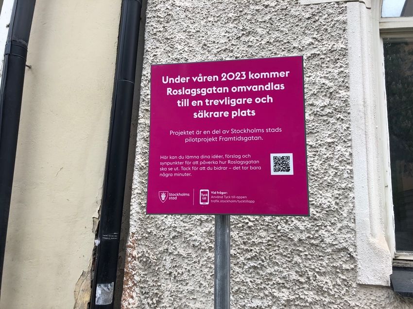
Abstract
The aim of this paper is to explore contemporary trends in the field of urban planning in
Stockholm, Sweden, especially in the context of the COVID-19 pandemic. The aim is
furthermore to, from an urban justice perspective, investigate the potential application of the
“15-minute city” in Stockholm, a planning model with the central premise of residents having
no longer than 15 minutes to basic services and functions by foot or bicycle. A variation of
the concept is the “one-minute city”, used to describe the street transformation projects
Framtidsgatan and Street Moves. The findings suggest that the pandemic has more or less
confirmed the strategic direction of the city, rather than changing it. The 15-minute city model
is not explicitly mentioned in any strategies or planning documents, but the city’s planning
seems to be guided by principles in line with those of the model, for instance in the centering
of components such as proximity, density and (physical) diversity. The 15-minute city model
and relevant street transformation projects further primarily seem to address justice issues
through spatial redistribution. On the street level, this entails transforming space intended for
cars into recreational space, to the benefit of pedestrians and cyclists. On the regional level, it
entails a restructuring of the built form in compliance with components such as proximity,
density and diversity, in order to bridge the gap in accessibility to basic services and functions
between different social groups. The analysis suggests that spatial changes in accordance with
the 15-minute city model can have some positive effects in furtherance of justice but that this
is highly dependent on these measures being implemented in socio-economically vulnerable
areas as well as there being measures in place to assure that local residents are not displaced
through gentrification, among other things.

Keywords: 15-minute city, one-minute city, post-pandemic city, COVID-19, pandemic, street
transformation, urban justice, just city, Stockholm
Sammanfattning
Svensk titel: En rättvis post-pandemisk stad: en undersökning av rumsliga förändringar i
form av 15-minutersstaden och dess förmåga att bekämpa sociala ojämlikheter i Stockholm

Syftet med denna uppsats är att utforska kontemporära trender inom området urban planering
i Stockholm, Sverige, särskilt i samband med coronapandemin. Syftet är vidare att, från ett
rättviseperspektiv, utforska den potentiella applikationen av ”15-minutersstaden” i
Stockholm, en planeringsmodell vars utgångspunkt är att boende inte ska ha mer än 15
minuter till grundläggande service och funktioner till fots eller på cykel. En variant av
konceptet är ”1-minutsstaden”, som bland annat används för att beskriva
gatutransformationsprojekten Framtidsgatan och Street Moves. Resultaten tyder på att
pandemin mer eller mindre har bekräftat stadens strategiska inriktning, snarare än ändrat den.
15-minutersstaden nämns inte i någon av stadens strategier eller planeringsdokument, men
stadens planering verkar styras i hög grad av principer i linje med modellens, till exempel i
hur de båda centrerar komponenter som närhet, täthet, och (fysisk) diversitet. 15-
minutersstaden och relevanta gatutransformationsprojekt verkar huvudsakligen hantera
rättvisefrågor genom rumslig omfördelning. På gatunivån medför detta en omvandling av ytor
menade för bilar till vistelseytor, till förmån för gående och cyklister. På den regionala nivån
medför detta en omstrukturering av den byggda miljön i överensstämmelse med komponenter
som närhet, täthet och diversitet, för att överbrygga klyftan i tillgänglighet till grundläggande
service och funktioner mellan olika samhällsgrupper. Analysen tyder på att rumsliga
förändringar i enlighet med 15-minutersstaden kan ha några positiva effekter för att främja
rättvisa, men att detta är högt beroende på att dessa åtgärder utförs i socioekonomiskt utsatta
områden, samt att det finns samt att det finns åtgärder på plats för att säkerställa att
lokalbefolkningen inte trängs undan genom gentrifiering, bland annat.

Nyckelord: 15-minutersstaden, 1-minutsstaden, post-pandemisk stad, COVID-19, pandemi,
taktisk urbanism, gatutransformation, urban rättvisa, rättvis stad, Stockholm
Acknowledgements
This paper would not be possible were it not for the contributions, both direct and indirect, of
a number of people. First and foremost, I would like to extend my gratitude to my thesis
supervisor Tigran Haas who has provided indispensable guidance throughout the entire
writing process. I would also like to thank the interviewees who were kind enough to take the
time out of their day and contribute to the study with their invaluable insights. Last but not
least, I would like to thank my family and friends who have constituted a crucial support
network throughout the writing process.
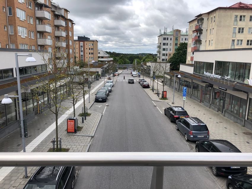
Table of contents
1 Introduction ......................................................................................................................... 1
   1.1 Aim and research questions .......................................................................................... 2
   1.2 Scope and delimitations ................................................................................................ 2
   1.3 Disposition ................................................................................................................... 3
2 Background ......................................................................................................................... 3
   2.1 The 15-minute city........................................................................................................ 3
   2.2 The one-minute city ...................................................................................................... 6
   2.3 Relation to prior urban planning paradigms................................................................... 7
       2.3.1 The neighborhood unit ........................................................................................... 7
       2.3.2 The ABC city ......................................................................................................... 8
       2.3.3 New urbanism ........................................................................................................ 9
       2.3.4 Tactical urbanism................................................................................................. 10
   2.4 Stockholm today ......................................................................................................... 10
       2.4.1 Vision .................................................................................................................. 10
       2.4.2 Comprehensive plan............................................................................................. 11
       2.4.3 Urban mobility strategy........................................................................................ 12
       2.4.4 Other documents .................................................................................................. 14
       2.4.5 Street transformation projects............................................................................... 15
3 Theoretical framework ...................................................................................................... 17
   3.1 The just city ................................................................................................................ 17
       3.1.1 Equity .................................................................................................................. 17
       3.1.2 Diversity .............................................................................................................. 18
       3.1.3 Democracy........................................................................................................... 19
4 Methodology ..................................................................................................................... 20
   4.1 Research design .......................................................................................................... 20
   4.2 Literature review ........................................................................................................ 20
   4.3 Document analysis ...................................................................................................... 21
   4.4 Interviews ................................................................................................................... 21
       4.4.1 Structure .............................................................................................................. 21
       4.4.2 Interviewees ......................................................................................................... 22
       4.4.3 Ethical considerations .......................................................................................... 23
   4.5 Direct observations ..................................................................................................... 23
5 Findings ............................................................................................................................ 23
   5.1 Contemporary trends in urban planning ...................................................................... 23
       5.1.1 Changed movement patterns ................................................................................ 23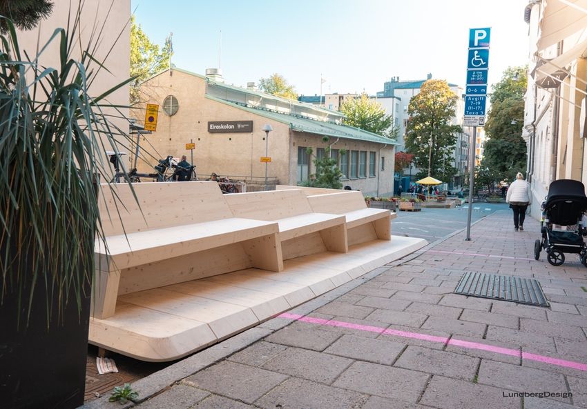
5.1.2 Different prioritizations, approaches or models .................................................... 24
       5.1.3 The city’s approach to justice issues ..................................................................... 26
   5.2 The 15-minute city...................................................................................................... 28
       5.2.1 Interpretations of the concept ............................................................................... 28
       5.2.2 Application of the concept in Stockholm .............................................................. 29
       5.2.3 Connectivity between districts.............................................................................. 30
       5.2.4 Inertia from existing urban form, infrastructure and norms ................................... 30
   5.3 Street transformation projects ..................................................................................... 31
       5.3.1 Implementation in socio-economically vulnerable areas ....................................... 31
       5.3.2 Connection to broader strategies .......................................................................... 33
       5.3.3 Changed view of the street ................................................................................... 33
       5.3.4 Fast and cheap street transformations ................................................................... 34
       5.3.5 Focus on public engagement ................................................................................ 34
   5.4 How the concepts and projects address justice issues .................................................. 38
       5.4.1 Spatial redistribution ............................................................................................ 38
       5.4.2 Accessibility ........................................................................................................ 38
       5.4.3 Affordability ........................................................................................................ 39
6 Analysis ............................................................................................................................ 39
   6.1 Equity ......................................................................................................................... 40
   6.2 Diversity ..................................................................................................................... 41
   6.3 Democracy ................................................................................................................. 42
7 Discussion ......................................................................................................................... 43
8 Conclusion ........................................................................................................................ 45
References ............................................................................................................................ 47
1 Introduction
The ongoing COVID-19 pandemic has had a markedly unequal impact within our cities. In
the county of Stockholm, Sweden, 14 out of 10,000 people had died of the virus in the lowest
income group as of June 2020, compared to just 2.6 out of 10,000 in the highest income group
(Bartelink et al. 2020). In Sweden as a whole, factors such as ethnic background and
education level have also been found to play a significant role in determining your risk of
infection and mortality (Coronakommissionen 2021). Foreign-born people, for instance, run a
particularly high risk of developing serious symptoms and dying, even when accounting for
other socio-economic, demographic and medical factors (ibid.). Furthermore, the highest
infection rate in the early stages of the pandemic was seen in socio-economically vulnerable
areas of Stockholm, such as Skärholmen, Spånga-Tensta and Rinkeby-Kista (Nobel and
Nygren 2021). This unequal impact did not emerge in a vacuum of course; rather, it reflects
structural inequalities which were there all along. As such, the pandemic prompts us to
question contemporary paradigms within the discipline of urban planning and consider new
planning models, capable of addressing these structural inequalities and other vulnerabilities.
One such potential planning model which has gained considerable momentum during the
pandemic is the “15-minute city” (Pozoukidou 2021).

The 15-minute city concept (“la ville du quart d’heure” in French) was conceived by Carlos
Moreno in 2016 (Moreno 2016) and popularized in 2020 after being incorporated into Paris
mayor Anne Hidalgo’s program Paris en Commun as part of her successful re-election
campaign (Reid 2020; Willsher 2020). The central premise of this planning model is that
residents of a city should be able to “access all of their basic essentials at distances that would
not take them more than 15 minutes by foot or by bicycle” (Moreno et al. 2021, p. 100). This
is primarily meant to combat car dependency in our cities and, consequently, address issues
surrounding ecological sustainability, social inequality and community participation (ibid.).
The planning model has been advocated by C40 Cities, a global network of cities with the aim
of combatting climate change, as an organizing principle for urban development as cities
work toward COVID-19 recovery (C40 Cities 2020). The C40 Cities network points to
existing “15-minute city-style” visions, plans and programs, such as Portland’s “complete
neighborhoods” from the 2015 Climate Action Plan, Melbourne’s “20-minute neighborhoods”
from Plan Melbourne 2017-2050, as well as Paris’s aforementioned “ville du quart d’heure”,
among others (ibid.). A Swedish twist on the concept is what Dan Hill, the former director of
strategic design at the Swedish national innovation body Vinnova, calls the “one-minute city”
(O’Sullivan 2021).

Considered on a larger timescale, the COVID-19 pandemic is a relatively new phenomenon
and things are still unfolding at a rapid pace as of the writing of this paper. The exact shape
which the post-pandemic city will take on is not yet set in stone. There is thus a great need for
research on different planning approaches and models, both new and old, and their utility in
the creation of a better post-pandemic city. This means being able to address new challenges
which have emerged as a consequence of the pandemic, as well as pre-existing ones which the
pandemic may have provided new insights on. Structural inequality is one such challenge.
The proliferation of the 15-minute city model (and variations thereof) during the pandemic,
proponents of which deem capable of addressing these very challenges, thus makes it warrant
its own analysis. It is this that I intend to contribute with, at least in small part, in this paper.

                                                 1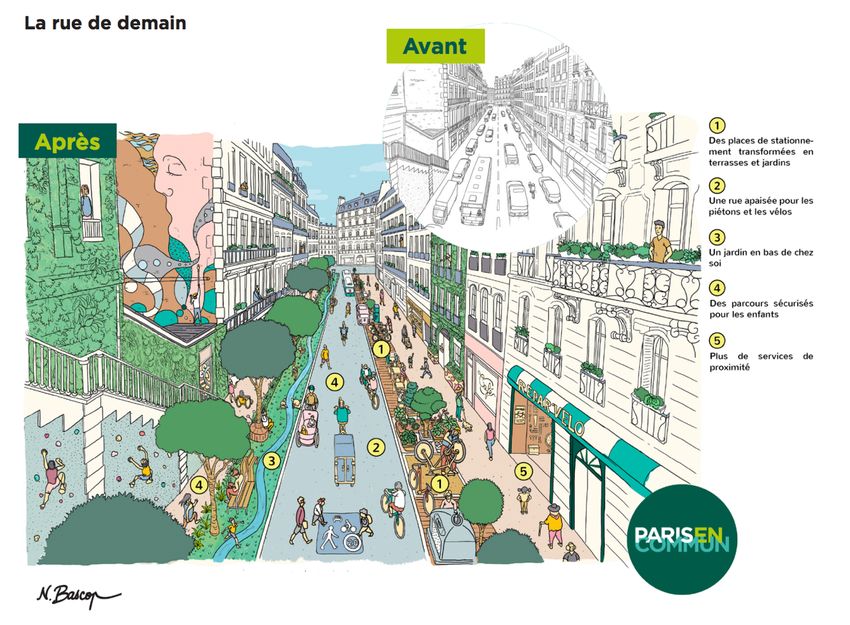
1.1 Aim and research questions
The broader aim of this paper is to explore contemporary trends in the field of urban planning
in Stockholm, Sweden, especially in the context of the COVID-19 pandemic. This entails, in
part, an examination of the strategic direction of the city. Furthermore, it entails an
examination of the impact of the pandemic on the strategic direction of the city, for instance
in the utilization of new planning approaches, models or principles. Of particular interest is
the city’s approach to justice issues and any potential impact which the pandemic might have
had on this. The following research question has been formulated to guide the investigation in
service of this aim:

   -   What impact, if any, has the COVID-19 pandemic had on the field of urban planning
       in Stockholm?

This paper further aims to investigate the 15-minute city model and its application in
Stockholm. Since this planning model has primarily risen to prominence during the pandemic,
if not because of the pandemic, this aim can be understood as contributing to the broader aim
of exploring contemporary trends in the field of urban planning in Stockholm. Furthermore,
this aim can be understood as comprising both a descriptive and a normative element. The
descriptive element entails an examination of if and how the planning model is being applied
in Stockholm today. The normative element entails an evaluation of the capability of the
planning model, when applied in Stockholm, to contribute to the creation of a more just city.
Two research questions have been formulated to guide the investigation in service of this aim:

   -   Is the field of urban planning in Stockholm in any way guided by the planning and
       design principles of the 15-minute city model?
   -   Can the application of the 15-minute city model in Stockholm contribute to the
       creation of a more just city?

1.2 Scope and delimitations
This study has a somewhat exploratory character, in that it has evolved throughout the course
of the investigation and has allowed for unexpected topics to emerge and be considered. This
has been intentional to some degree and is reflected in the choice of research design and
methods, for instance in the use of semi-structured interviews which do not require the
interviewees to adhere to strict and predetermined discussion topics. The one-minute city
concept, for instance, was encountered a lot in the early stages of investigating the 15-minute
city and its application in Stockholm and thus ended up being incorporated into the
investigation. Consequently, the study has further ended up adopting a strong focus on street
transformations. The validity of examining these arguably fragmented aspects as part of one
study is discussed in further detail toward the end of the paper.

This study is primarily concerned with Stockholm municipality and does not consider to as
high of an extent the broader Stockholm region, metropolitan area, urban area or any other
distinction which may exist. This provides distinct geographical borders within which to limit
the analysis. Furthermore, with Stockholm municipality being an administrative unit with
some level of autonomy, this implies a set number of strategies, planning documents and
other material which have to be considered and which can facilitate the tracking of the city’s
strategic direction.

                                               2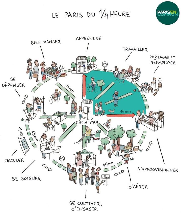
1.3 Disposition
The paper begins in chapter 2 by providing a general overview of the 15-minute city model
and other related planning concepts, along with current strategies and projects in Stockholm
with some relevance to the investigation. The theoretical framework used to evaluate the
capability of the 15-minute city model to contribute to the creation of a more just city is
presented in chapter 3. Chapter 4 presents the research design and methods used to answer the
research questions and chapter 5 presents the findings of the conducted study. These findings
are further analyzed in chapter 6, wherein the capability of the 15-minute city model to
contribute to the creation of a more just city is evaluated. Then, in chapter 7, reflections
surrounding the findings, methodology, theoretical framework and more are provided, and the
paper concludes with a brief summary in chapter 8.

2 Background
In this chapter, the concepts, strategies and projects of relevance to the investigation are
outlined. This includes the 15-minute and one-minute city concepts and their relation to prior
urban planning paradigms, governing documents adopted by Stockholm municipality to guide
the planning of the city as well street transformation projects in the city with some connection
to the relevant concepts.

2.1 The 15-minute city
The “15-minute city” concept (“la ville du quart d’heure” in French) was conceived by Carlos
Moreno in 2016 (Moreno 2016), the central premise of which being that residents of a city
should be able to “access all of their basic essentials at distances that would not take them
more than 15 minutes by foot or by bicycle” (Moreno et al. 2021, p. 100). The concept was
further popularized in 2020 after being incorporated into Paris mayor Anne Hidalgo’s
program Paris en Commun as part of her successful re-election campaign (Reid 2020;
Willsher 2020). Since then, it has been cited by a number of other cities as part of their work
toward COVID-19 recovery. In April 2020, Milan announced a pilot project which aims to
offer services and quality of life within the space of 15 minutes on foot from home (Whittle
2020). In June 2020, Madrid announced plans to replicate Barcelona’s “superblock” model as
part of its transition toward “a city of 15 minutes”, where most daily activities can be
performed within a radius of half a kilometer by foot (Montojo 2020). The planning model
has been advocated by C40 Cities, a global network of cities with the aim of combatting
climate change, as an organizing principle for urban development as cities work toward
COVID-19 recovery (C40 Cities 2020). The C40 Cities network also points to cities with “15-
minute city-style” visions, plans and programs which predate the pandemic. These include
Portland’s “complete neighborhoods” from the 2015 Climate Action Plan (City of Portland
and Multnomah County 2015) and Melbourne’s “20-minute neighborhoods” from Plan
Melbourne 2017-2050 (Victoria State Government 2017), among others.

Moreno et al. (2021) specify six essential social functions which residents should be able to
fulfil in order to sustain a decent urban life: living, working, commerce, healthcare, education
and entertainment. Attaining these functions, they claim, requires a restructuring of the urban
built landscape which “complies with components such as proximity, diversity, density and
ubiquity” (p. 100). Moreno et al. further propose a “modified 15-minute city framework” (see

                                               3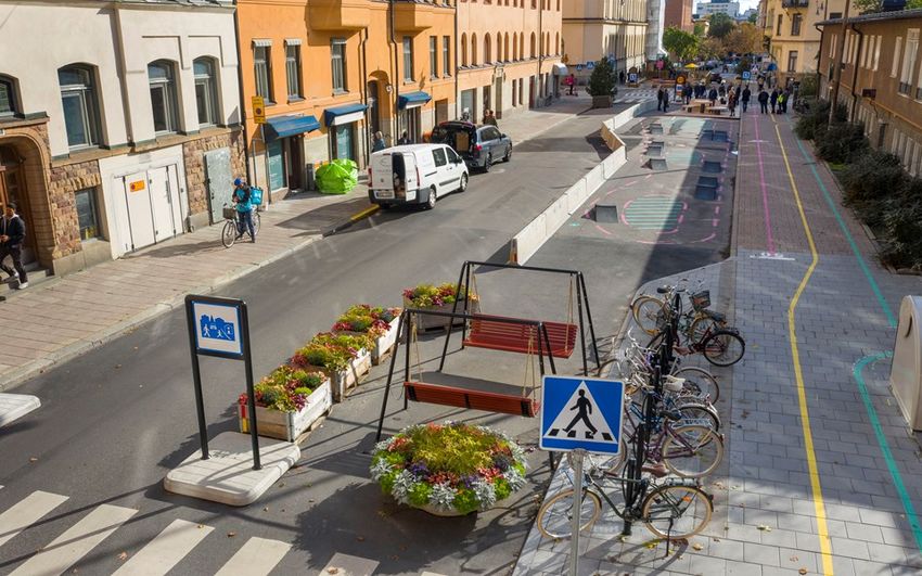
Figure 1), which according to them was developed after observing the challenges endured by
cities around the world during the pandemic. The framework encompasses the dimensions of
density, proximity, diversity and digitalization. Density here refers to the number of people
per area unit and Moreno et al. argue that there exists some optimal density such that all the
essential functions can be provided without the need for a car. Proximity to essential
functions, both in a temporal and spatial sense, is at the core of the 15-minute city model,
reducing the time lost in commuting and the negative ecological, economic and social impacts
associated with it. Diversity refers to the need for mixed-use neighborhoods as well as
diversity in culture and people. Finally, digitalization refers to the utilization of digital tools
and solutions in order to, among other things, reduce the need for travel as well as promote
more sustainable modes of transport.

Figure 1. 15-minute city framework (Moreno et al. 2021)

Moreno et al. (2021) primarily characterize the 15-minute city model as tackling car
dependency, through which it is meant to address issues surrounding ecological sustainability,
social inequality and community participation. By planning for walkability and cycling, they
mean, the disparate accessibility between different social groups to various facilities can be
bridged. Furthermore, they claim that the reduced need for travel to basic facilities such as
public spaces would give more time and opportunities for community participation and
interaction. The C40 Cities network centers notions such as community and equity as well.
They highlight the need for social spaces which build community and claim that a 15-minute
city strategy should emphasize equal access to services, amenities and green space (C40
Cities 2021). The C40 Cities network further stresses the importance of prioritizing 15-minute
city-style investments for lower-income neighborhoods, taking steps to ensure that residents
in such neighborhoods are not displaced through gentrification, providing affordable housing
and diversifying the mix of homes within neighborhoods (ibid.).

                                                4
Figure 2 is a diagram of the 15-minute city model as proposed by the Paris en Commun
program. Clockwise from the top it says “learn”, “work”, “share and reuse”, “get supplies”,
“get fresh air”, “develop and engage”, “take care of oneself”, “get around”, “exercise” and
“eat well”, implying that you should be able to do all of this within 15 minutes from your
home. (Paris en Commun 2020)
Figure 2. "Quarter-hour Paris" (Paris en Commun 2020)
In Figure 3, five street transformation principles in accordance with the 15-minute city model
of the Paris en Commun program are listed and illustrated. These are (1) “parking spaces
transform into terraces and gardens”, (2) “a calm street for pedestrians and bicyclists”, (3) “a
garden below your home”, (4) “safe paths for children”, and (5) “more local services”. (Paris
en Commun 2020)
5Figure 3. "The street of tomorrow" (Paris en Commun 2020)
2.2 The one-minute city
The term “one-minute city” was coined by Dan Hill, the former director of strategic design at
the Swedish national innovation body Vinnova (O’Sullivan 2021). In a blog post from
September 2020, Hill (2020a) describes the concept as concerning the immediate environment
outside your front door and the numerous tight circles of engagement which overlap there. In
a later blog post from January 2021, he describes the concept as zooming into 15-minute city
model and “[focusing] on the immediate streetscape, exploring models for co-designing,
caring and maintaining the street together, and thus shifting systems and cultures around
mobility, biodiversity, culture, conviviality, and so on” (Hill 2021). The one-minute city
model, rather than being a rejection of the 15-minute city model, is thus characterized as an
attempt at refining it and as working within its broader framework (The Agility Effect 2021).
In the blog post from September 2020, Hill (2020a) specifically ties the one-minute city
concept to the project Street Moves which Vinnova has been collaborating with ArkDes on.
This project involves the implementation of interactive modules in street environments to
enhance their social function, among other things (ArkDes n.d.a). This is how the concept has
primarily been portrayed in the international media, i.e. in connection to the Street Moves
project (Orange 2021; O’Sullivan 2021; Peters 2021). In the later blog post from January
2021, Hill (2021) more broadly ties the concept to Vinnova’s “street mission”, an initiative
with the stated aim of, through so-called mission-oriented innovation, making every street in
Sweden sustainable, healthy and full of life (Vinnova 2021). This initiative comprises various
Vinnova-financed street transformation projects, including Smarta Gator, Framtidsgatan and
Street Moves (ibid.). Starting in September 2020, the project Framtidsgatan has involved the
implementation of various temporary measures on three so-called future streets in central
6Stockholm (Stockholms stad 2022a), in connection to which the Street Moves modules were
also implemented (ArkDes n.d.a). In a video for TEDx Talks, Hill (2020b) further refers to
both the project Framtidsgatan and the project Street Moves in regard to the one-minute city
concept. All of the above-mentioned street transformation projects are described in further
detail in a later section.
2.3 Relation to prior urban planning paradigms
2.3.1 The neighborhood unit
The term “neighborhood unit” was coined by William E. Drummond as part of his submission
to the Chicago City Club’s competition of 1912-1913, the results of which were widely
publicized 1913-1925 (Johnson 2002). The most influential formulation of the term, however,
came in 1929 with the publication of Clarence A. Perry’s monograph in the Regional Survey
of New York and Its Environs (Lawhon 2009). The underlying principle of Perry’s (1929)
conceptualization the neighborhood unit is that “an urban neighborhood should be regarded
both as a unit of a larger whole and as a distinct entity in itself” (p. 34). As such, while
residents are dependent on certain functions outside of their neighborhood, certain other
functions are considered strictly local and essential to a well-arranged residential community
according to this model. Perry identifies four such neighborhood functions: (1) the elementary
school, (2) small parks and playgrounds, (3) local shops, and (4) residential environment.
Regarding local shops, Perry asserts that they should be spatially concentrated and provide for
varied requirements. By “residential environment” he refers to all such aspects which
contribute to the “character” of a district, such as the quality of architecture, layout of streets,
planting along curbs and in yards, etc.
The planning model suggests the division of residential developments into so-called
neighborhood units, with each unit being suitable for a single “neighborhood community”
(Perry 1929). Each unit should then be planned and designed such that adequate provision of
the four neighborhood functions listed above is provided. To achieve this, Perry proposes six
principles for the planning and design of a neighborhood unit (see Figure 4). These are as
follows:
1. Size: a residential unit development should provide housing for that population for
which one elementary school is ordinarily required, its actual area depending upon
population density.
2. Boundaries: the unit should be bounded on all sides by arterial streets, sufficiently
wide to facilitate its by-passing by all through traffic.
3. Open spaces: a system of small parks and recreation spaces, planned to meet the needs
of the particular neighborhood, should be provided.
4. Institution sites: sites for the school and other institutions having service spheres
coinciding with the limits of the unit should be suitably grouped about a central point,
or common area.
5. Local shops: one or more shopping districts, adequate for the population to be served,
should be laid out in the circumference of the unit, preferably at traffic junctions and
adjacent to similar districts of adjoining neighborhoods.
6. Internal street system: the unit should be provided with a special street system, each
highway being proportioned to its probable traffic load, and the street net as a whole
7being designed to facilitate circulation within the unit and to discourage its use by
through traffic. (Perry 1929, pp. 34-35)
Figure 4. Neighborhood unit principles (Perry 1929)
The neighborhood unit model, as conceptualized by Perry, has seen widespread adoption and
application in urban planning. In the United States, the planning model was adopted by
various professional organizations and public agencies the decades following its conception,
as well as incorporated into many local planning manuals and zoning ordinances (Banerjee
and Baer 1984). It has been utilized in new town development both in the United States and in
other countries (ibid). According to Lynch (1981), planning theorists “picked up the idea of
the neighborhood as the basic building block of a city” (p. 246). He further claims that the
neighborhood unit model, as of 1981, was still influential in city design throughout the world.
2.3.2 The ABC city
ABC-staden (“the ABC city” in English) – ABC being an acronym for “arbete”, “bostad” and
“centrum” (“work”, “housing” and “center” respectively in English) – is an urban planning
concept predominantly used during the post-war period in Sweden (Stockholms stad 2016a;
Urban Utveckling n.d.). It suggested the creation of independent smaller settlements around
big cities, within which you can live and work as well as have access to stores and public
services and various other facilities (ibid.). Sven Markelius, the planning director of
Stockholm 1944-1954, is generally considered to be the originator of the concept, taking
inspiration from new town development in England (ibid.). The concept took concrete form in
8the master plan for Stockholm of 1952 (Stockholms stad 1952), the predecessor to what today
is called a comprehensive plan, though the term “ABC-stad” is never explicitly used here. A
schematic diagram from the master plan of this type of development is shown in Figure 5,
with central functions in the middle surrounded by multi-apartment buildings, single-family
housing further out, workplaces to the right and with the area being cut through by the
subway (Stockholms stad 1952). Vällingby, a suburban area to the west of central Stockholm
which was inaugurated in 1954, is considered to be the first realization of the concept and is
probably also the most well-known (Stockholms stad 2016a; Urban Utveckling n.d.). Farsta,
to the south of central Stockholm and inaugurated in 1960, is another key example (ibid.).
Figure 5. Schematic diagram of an "ABC town" (Stockholms stad 1952)
2.3.3 New urbanism
New urbanism is an urban design movement which emerged in the 1980s as a reaction to
post-war suburban development, drawing inspiration from pre-industrial urban environments
(Ellin 1996). Its central premise, according to Talen (2000), is that “suburban development in
the United States fails environmentally, socially, aesthetically, and ethically because of its
segregation of land uses” (p. 324). She also means that the creation of a sense of community
is at the center of new urbanist design theory (Talen 1999). Ellin (1996) states that new
urbanism aims to “avoid the excessive separation of functions of modern urbanism along with
the social and environmental harm that accompanies it” (p. 93). The movement is further
characterized by Ellis (2002) as “an important alternative to prevailing patterns of low-
density, auto-dependent land development” (p. 261).
9New urbanists can generally be said to subscribe to the values, beliefs and design principles
outlined in the Charter of the New Urbanism (Congress for the New Urbanism [CNU] 2000).
At the regional level, this formal document advocates for the prioritization of infill
development within existing urban areas over peripheral expansion, in order to conserve
environmental resources, economic investment and social fabric. It also advocates for an even
distribution of affordable housing throughout the region to match job opportunities and avoid
pockets of poverty, as well as for transit, pedestrian and bicycle systems which maximize
accessibility and mobility throughout the region while reducing car dependency. At the
neighborhood level, the document advocates for compact, pedestrian-friendly and mixed-use
development. It states that “many activities of daily living should occur within walking
distance” (CNU 2000, p. 340). Furthermore, it recommends a broad range of housing types
and price levels within neighborhoods as to “bring people of diverse ages, races, and incomes
into daily interaction, strengthening the personal and civic bonds essential to an authentic
community” (ibid.). At the street and block level, the document advocates for safe and
comfortable public spaces which encourage walking, as well as for the preservation and
renewal of historic urban environments, among other things.
2.3.4 Tactical urbanism
The term “tactical urbanism” is attributed to urbanist and planner Mike Lydon (Mould 2014).
It came into common use around 2011 with the publication of Tactical Urbanism: Short-term
Action, Long-term Change, showcasing a number of temporary public space improvement
projects across North America (Lydon 2011; 2012). Lydon and Garcia (2015) describe
tactical urbanism as “an approach to neighborhood building and activation using short-term,
low-cost, and scalable interventions and policies” (p. 2). It is further described as featuring the
following characteristics: (1) a deliberate, phased approach to instigating change, (2) the
offering of local solutions for local planning challenges, (3) short-term commitment and
realistic expectations, (4) low risks, with a possibly high reward, and (5) the development of
social capital between citizens and the building of organizational capacity between public-
private institutions, non-profits, and their constituents (ibid.). The approach is meant to
improve the “livability” of towns and cities, starting at the street block and building scale
(ibid.).
2.4 Stockholm today
2.4.1 Vision
Vision 2040 – Möjligheternas Stockholm (“Vision 2040 – A Stockholm of Opportunities”) is
meant to provide Stockholm municipality and its various branches with a shared vision. The
vision is divided into three target areas. The first target area, “a versatile big city for
everyone”, envisions a city free from discrimination, where our differences are seen as an
asset and where everyone has the same opportunities regardless of ethnic background,
religious affiliation, gender, sexual orientation, etc. Housing, public spaces and public
transport is adapted and made accessible to elderly people and people with disabilities.
Furthermore, residents feel involved and have an influence on the urban development and
other local processes which affect their daily lives. The second target area, “sustainably
growing and dynamic”, envisions an ecologically sustainable city with a strong business
climate. The urban structure is attractive, dense, cohesive and mixed-use and the transport
system is capable of meeting the needs of both residents and businesses with a minimal
10climate impact. The third target area, “a smart and innovative big city”, envisions a
competitive, innovative and knowledge-intensive city which makes full use of the
opportunities presented by digitalization to better facilitate the daily lives of residents.
(Stockholms stad 2020a)
The current vision described above was adopted in June of 2020, replacing the previous one
titled Vision 2040 – Ett Stockholm för alla (“Vision 2040 – A Stockholm for Everyone”) from
2017 (Stockholms stad 2020b). This vision was divided into four target areas: “a Stockholm
that holds together”, “a climate-smart Stockholm”, “an economically sustainable Stockholm”
and “a democratically sustainable Stockholm” (Stockholms stad 2017a). Preceding the vision
from 2017 is Stockholm municipality’s first vision document adopted in 2007, titled Vision
2030 – Ett Stockholm i världsklass (“Vision 2030 – A World-Class Stockholm”) (Stockholms
stad 2020b). This vision was divided into three target areas: “versatile and eventful”,
“innovative and growing” and “citizens’ Stockholm” (Stockholms stad 2007). Work started
on the current revised vision in 2019 with a basis in previous versions as well as in the long-
term objectives set out in the city council’s budget for 2019 (Stockholms stad 2019). Another
stated reason for the latest revision concerns addressing trends and challenges of importance
for the Stockholm region, such as demographic change, climate change, digitalization,
tougher international competition and increased social polarization (ibid.).
2.4.2 Comprehensive plan
The current comprehensive plan of Stockholm municipality, Översiktsplan för Stockholms
stad, was adopted in 2018. The purpose of the document is to provide guidance concerning
the use, development and preservation of the built environment, as well as clarify how this
will contribute in accomplishing the city’s vision. The comprehensive plan names four broad
urban development goals. The first urban development goal, “a growing city”, aims at
encouraging the growth of Stockholm, among other things by addressing the housing shortage
through a high rate of housing development. It also advocates for the implementation of
various other functions and services, such as offices, schools, hospitals, parks, public places
and communications, to create an attractive and well-functioning city. Furthermore, an
emphasis on high capacity and space efficient modes of transport such as walking, cycling
and public transport is meant to make the city more accessible. (Stockholms stad 2018a)
The second urban development goal, “a cohesive city”, aims at creating stronger connections
between different city districts by creating more continuous urban spaces, street networks and
park networks, as well as by expanding the public transport system. This entails, among other
things, transforming certain major traffic routes into “urban corridors” (“urbana stråk” in
Swedish) which are lined with new buildings and with a clearer prioritization of walking,
cycling and public transport, in order to create more lively urban environments and merge
surrounding neighborhoods. In doing so, the aim is to facilitate the movement of different
groups of people in the same public environments, encouraging understanding and solidarity
and combatting social exclusion. (Stockholms stad 2018a)
The third urban development goal, “good public environment”, aims at providing a more
equal distribution between different city districts of such qualities, functions and services
which contribute to a good living environment. This entails strengthening local centers,
creating mixed-use urban environments, striving for a varied housing stock with a mix of
housing types, apartment sizes and forms of tenure, as well as providing attractive, safe and
accessible public environments. (Stockholms stad 2018a)
11Finally, the fourth urban development goal, “a climate-smart and resilient city”, aims at
reducing Stockholm’s climate impact while also making the city resilient to climate change
and other strains. This is to be accomplished through, among other things, a more efficient
land use, an energy-efficient design of buildings, the development of robust supply systems,
as well as the development of a network of greenery and water surfaces capable of cooling
down urban environments and reducing the risk of flooding. (Stockholms stad 2018a)
The current comprehensive plan was preceded by the one adopted in 2010 titled
Promenadstaden (“The Walkable City” in English) (Stockholms stad 2010). This
comprehensive plan was divided into four urban development strategies: (1) continuing to
strengthen central Stockholm, (2) investing in attractive focal points, (3) connecting different
parts of the city together, and (4) promoting a vibrant urban environment throughout the
whole city (ibid.). The current comprehensive plan cites a rapid population growth and other
challenges to accomplishing an ecologically and socially sustainable development as major
reasons for replacing the prior comprehensive plan (Stockholms stad 2018a). The urban
development strategies from the prior comprehensive plan of investing in attractive focal
points and connecting different parts of the city together are further pointed out as having not
been accomplished to a sufficient degree, thus being developed further in the current one
(Stockholms stad 2018b).
Since its adoption in 2018, two follow-ups have been conducted on the current comprehensive
plan, one for the period 2019-2020 and the other for the period 2019-2021. According to both
follow-ups, the city’s planning has generally been in line with the comprehensive plan. Some
areas in which the objectives of the comprehensive plan have been deemed to not be fully
achieved include total housing construction, distribution of different forms of tenure, as well
as the number of new workplaces to the south of the inner city and in other focus areas,
among other things. There is furthermore a lot of overlap regarding the suggested additional
measures of both follow-ups such as, among other things, approaches to increase housing
construction and to create more workplaces south of the inner city and in other focus areas
(Stockholms stad 2021a; 2022b).
2.4.3 Urban mobility strategy
Stockholm’s current urban mobility strategy (“framkomlighetsstrategi” in Swedish) was
adopted in 2012 and is meant to provide guiding principles in issues surrounding the city’s
streets and roads, in line with the city’s vision and comprehensive plan. The document
describes the city’s overall strategy for robustly and sustainably managing the future
increased need for transport following population growth as comprising three components.
The first component concerns urban planning and entails dense and mixed urban development
that reduces the need to travel. The second component concerns infrastructure planning and
entails a substantial expansion of public transport and a road network that leads away major
traffic flows. The third component concerns traffic planning and entails optimizing the use of
the existing infrastructure. (Stockholms stad 2012)
The urban mobility strategy further defines four more specific planning aims for the road and
street network. Planning aim A states that an increased number of people and amount of
goods should be able to be moved through a greater use of high-capacity means of transport
such as public transport, cycling and walking, as well as goods vehicles with a high load
factor. Planning aim B states that accessibility in the road and street network is to be
12enhanced by increasing speeds for high-capacity means of transport and raising travel-time
reliability for all road users. Planning aim C states that the role of roads and streets as
attractive places is to be strengthened through improved walkability. Planning aim D states
that the negative effects of road and street traffic should be minimized by encouraging car use
only where it can create the most public benefit. (Stockholms stad 2012)
In 2018, Stockholm municipality complemented their urban mobility strategy with the
document Strategi för offentliga rum (“Strategy for Public Spaces” in English). According to
this document, planning aims A, B and D of the urban mobility strategy focus on mobility
while planning aim C focuses on recreation (“vistelse” in Swedish). It is this latter aspect
which the strategy for public spaces aims to develop further and it names five planning
principles to this end. The first planning principle is to strengthen the role of the street as a
place for recreation, entailing a clearer prioritization of street functions and redistribution of
street space. The second planning principle is to bind together different parts of the city
through a network of public spaces. The third planning principle is to raise the quality of
public spaces in the entire city, entailing minor alterations in the inner city while housing
development outside the inner city will enable greater alterations which increase the
attractivity of public spaces. The fourth planning principle is to create public spaces which
facilitate recreation all year round and around the clock. The fifth and final planning principle
named in the strategy for public spaces is for the design of public spaces in a way which
facilitates flexible use. (Stockholms stad 2018c)
Starting in 2020, Stockholm municipality has been working on a revised version of the urban
mobility strategy, with a basis in emerging mobility services and sharing economy. A stated
reason for the revision is that a lot has changed since the adoption of the strategy in 2012,
such as Stockholm growing by 100,000 people, as well as a need to clarify the city’s approach
to emerging trends such as electrification and digitalization. The work to revise the document
has involved monitoring and reviewing traffic strategies internationally, citing Paris’s 15-
minute city, Barcelona’s superblocks, London’s healthy streets and others as good examples.
Furthermore, it is claimed that the COVID-19 pandemic, by having a significant and rapid
effect on travel patterns, has emphasized the need for flexibility in the transport system as
well as for public spaces with high recreational values, thus confirming the direction of the
revised strategy. (Stockholms stad 2021b)
In a draft proposal of the revised urban mobility strategy from December 2021, the overall
focus of prioritizing walking, cycling, public transport and efficient freight traffic is claimed
to carry over from the 2012 strategy. Providing more space for recreation as well as planning
for a dense and mixed city are also claimed to be of continued importance. The draft further
includes four newly formulated planning aims, although these seem to correspond to the
planning aims from the 2012 strategy to some extent. Planning aim A concerns capacity and
promotes a greater use of high-capacity means of transport such as public transport, cycling
and walking, as well as a more effective freight traffic. Planning aim B concerns accessibility
(“framkomlighet” in Swedish) and promotes reducing travel times for public transport,
improving accessibility to walking, cycling and efficient freight traffic, as well as improving
the reliability of all means of transport. Planning aim C concerns attractivity and promotes a
design of public spaces which improves walkability and strengthens recreational values.
Finally, planning aim D concerns sustainability and promotes transportation electrification as
well as minimizing the negative effects of road and street traffic by encouraging car use only
where it can create the most public benefit. As of the writing of this paper, the revised urban
mobility strategy has not yet been officially adopted. (Stockholms stad 2021c)
132.4.4 Other documents
Other documents which might be of relevance to the investigation are listed in Table 1, along
with a brief description.
Table 1. Other documents
RUFS 2050 The regional development plan for the Stockholm region, which includes
Stockholm municipality along with 25 other surrounding municipalities
(Stockholms läns landsting 2018).
Budget 2022 The city council of Stockholm decides on a budget for the city every year,
with the current one for 2022 having the target areas “a modern big city
with opportunities and freedom of choice for everyone”, “a sustainably
growing and dynamic big city with a high [economic] growth” and “an
economically sustainable and innovative big city for the future”
(Stockholms stad 2021d).
Guidelines This document aims at creating the conditions for all residents to have
for housing access to good housing, with elderly people, newly arrived immigrants,
provision unaccompanied immigrant children and adolescents, people with
2021-2024 disabilities, homeless people, victims of abuse, young people and young
adults, and students being pointed out as prioritized groups (Stockholms
stad 2020c).
Environment This document provides guidelines to make the city more ecologically
program sustainable, with seven prioritized goals being highlighted: (1) a fossil-free
2020-2023 and climate-positive Stockholm by 2040, (2) a fossil-free organization by
2030, (3) a climate-adapted Stockholm, (4) a resource-smart Stockholm,
(5) a Stockholm with biodiversity in well-functioning and cohesive
ecosystems, (6) a Stockholm with clean air and a good auditory
environment, and (7) a toxin-free Stockholm (Stockholms stad 2020d).
Greener This document provides guidelines for the planning, implementation and
Stockholm management of the city’s parks and natural areas, advocating for
Stockholm residents to have a good access to parks and nature with high
recreational and natural values, a strong green structure with a rich
biodiversity, as well as an efficient resource exploitation and an interplay
between management and development (Stockholms stad 2017b).
Pedestrian A complement to the urban mobility strategy which provides guidelines to
plan increase walkability in the city’s public spaces for the period 2015-2020
(Stockholms stad 2016b). In 2020, Stockholm municipality produced a
status report of completed measures in 2019 and planned measures for
2020 to achieve the goals of the pedestrian plan (Stockholms stad 2020e).
Bicycle plan A complement to the urban mobility strategy with the aim of making it
easier and safer to cycle in the city (Stockholms stad 2012). Work has also
started on a revised bicycle plan, titled Cykelstaden (“The Bicycle City” in
English), with a draft proposal from 2021 being available online
(Stockholms stad 2021e).
142.4.5 Street transformation projects
Framtidsgatan (“The Future Street” in English) can be divided into two phases, the first of
which being a pilot project financed and headed by Stockholm municipality, in collaboration
with the firms Spacescape and White, among others. This phase of the project was further
connected to the Vinnova-financed research project Smarta Gator. It saw the inauguration of
three so-called future streets in central Stockholm in September 2020, these being
Hälsingegatan in the district of Norrmalm, Parmätargatan in Kungsholmen and Tjärhovsgatan
in Södermalm. The stated aim was to develop a “learning and dialogue-driven design process”
for gradual street transformations, test new solutions for temporary street design, gain insights
for further work with gradual street transformations, as well as to create multifunctional
public spaces with more space for recreation and activities. The three streets were all in close
connection to schools and the children were included in the design process. The measures on
these streets were of a temporary character and removed around three to nine months after
implementation. An example of how one of these future streets looked is shown in Figure 6.
(Spacescape 2021; Stockholms stad 2022a; 2022c; 2022d; 2022e)
Figure 6. The future street Hälsingegatan 2020 (Stockholms stad 2022c)
The second phase of the project Framtidsgatan has been expanded to include the cities of
Stockholm, Gothenburg and Umeå (Stockholms stad 2022f). It is financed partly by the
municipalities and partly by Vinnova, with Spacescape having a collaborative role in this
phase as well. This phase of the project is also connected to the research project Smarta Gator.
The stated aim of this phase of the project is “to develop models to then conduct a quick
transformation of streets into multifunctional, inclusive and aesthetic urban environments”
(ibid., p. 2). These measures are meant to be more permanent than in the prior phase,
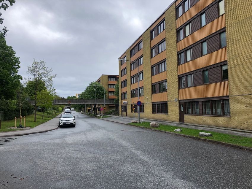
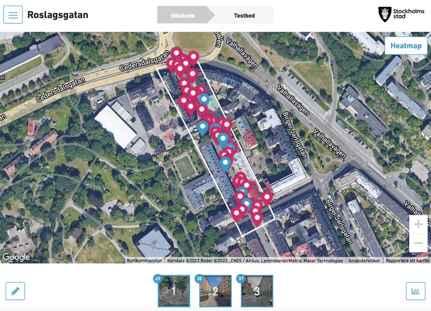
remaining in place for between a couple years to 15 years. In Stockholm, two streets have
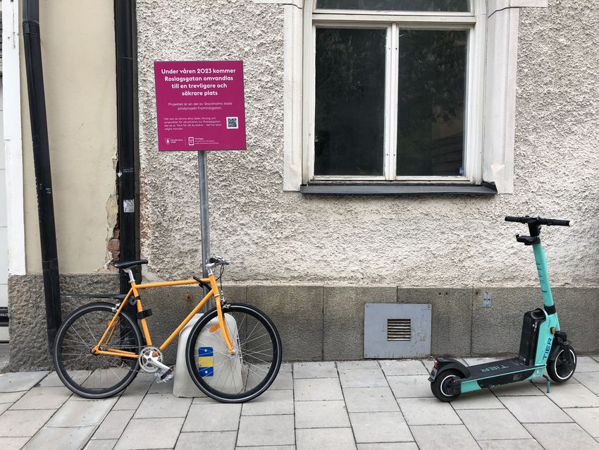
been chosen: Roslagsgatan in the district of Norrmalm and Helsingforsgatan in the district of
Rinkeby-Kista (Stockholms stad 2022g; 2022h). Work on this phase of the project is meant to
be active throughout 2022 and the first half of 2023 (Stockholms stad 2022f).
Smarta Gator (“Smart Streets” in English) is a Vinnova-financed research project in
collaboration between KTH, Chalmers, VTI, Spacescape, Sweco and White (Smarta Gator
15You can also read