6.11 VOLUME CAPACITY RATIOS - ARCHAEOLOGICAL & CULTURAL HERITAGE - BUSCONNECTS ...
←
→
Page content transcription
If your browser does not render page correctly, please read the page content below
6.11 Volume
Capacity
 Chapter 15 Ratios
2043    Opening Year
 Archaeological
+&15  Years
   Cultural    DoMinimum
            Heritage
vs DoSomething
AM Peak Hour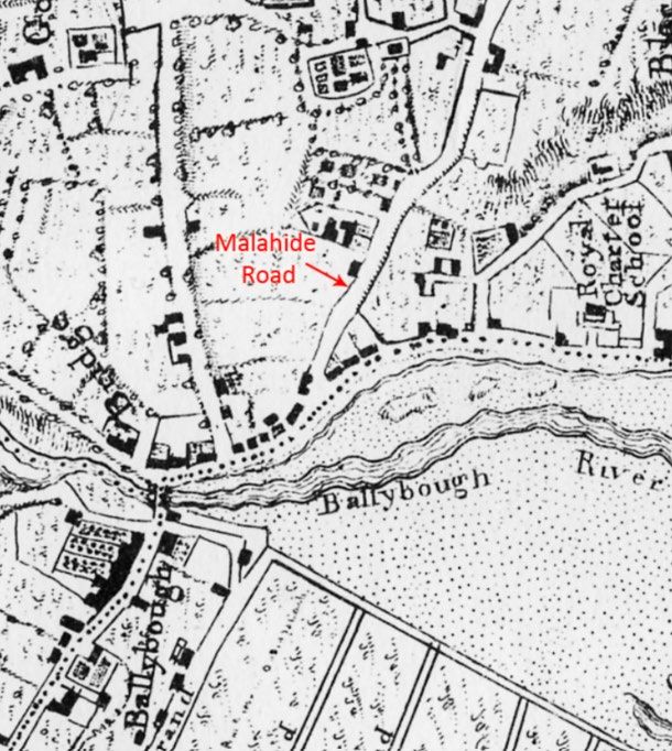
Environmental Impact Assessment Report (EIAR) Volume 2 of 4
Main Report

Contents
15.        Archaeological & Cultural Heritage ................................................................................................ 1
15.1       Introduction ......................................................................................................................................... 1
15.2       Methodology ....................................................................................................................................... 2
15.2.1 Introduction ......................................................................................................................................... 2
15.2.2 Study Area .......................................................................................................................................... 3
15.2.3 Relevant Guidelines, Policy and Legislation ...................................................................................... 4
15.2.4 Data Collection and Collation ............................................................................................................. 4
15.2.5 Appraisal Method for the Assessment of Impacts .............................................................................. 5
15.3       Baseline Environment......................................................................................................................... 8
15.3.1 Archaeological and Historical Background ......................................................................................... 8
15.3.2 Archaeological Heritage: Mayne River Avenue to Gracefield Road - Malahide Road ..................... 17
15.3.3 Archaeological Heritage: Gracefield Road to Marino Mart / Fairview - Malahide Road ................... 21
15.3.4 Proposed Construction Compound .................................................................................................. 23
15.4       Potential Impacts .............................................................................................................................. 25
15.4.1 Characteristics of the Proposed Scheme ......................................................................................... 25
15.4.2 ‘Do Nothing’ Scenario ....................................................................................................................... 25
15.4.3 Construction Phase .......................................................................................................................... 25
15.4.4 Operational Phase ............................................................................................................................ 27
15.5       Mitigation and Monitoring Measures ................................................................................................ 28
15.5.1 Construction Phase .......................................................................................................................... 28
15.5.2 Operational Phase ............................................................................................................................ 30
15.6       Residual Impacts .............................................................................................................................. 31
15.6.1 Construction Phase .......................................................................................................................... 31
15.6.2 Operational Phase ............................................................................................................................ 31
15.7       References ....................................................................................................................................... 32

Clongriffin to City Centre Core Bus Corridor Scheme
Environmental Impact Assessment Report (EIAR) Volume 2 of 4
Main Report

15. Archaeological & Cultural Heritage
15.1       Introduction
This Chapter of the Environmental Impact Assessment Report (EIAR) has considered the potential archaeological
and cultural heritage impacts associated with the Construction and Operational Phases of the Clongriffin to City
Centre Core Bus Corridor Scheme (hereafter referred to as the Proposed Scheme).

During the Construction Phase, the potential archaeological and cultural heritage impacts associated with the
development of the Proposed Scheme have been assessed. This included impacts on heritage assets, ground
disturbance and degradation of the setting and amenity of heritage assets due to construction activities such as
utility diversions, road resurfacing and road realignments.

During the Operational Phase, the potential archaeological and cultural heritage impacts have been assessed.

The assessment has been carried out according to best practice and guidelines relating to archaeological heritage
assessment, and in the context of similar large-scale infrastructural projects.

The aim of the Proposed Scheme when in operation is to provide enhanced walking, cycling and bus infrastructure
on this key access corridor in the Dublin region, which will enable and deliver efficient, safe, and integrated
sustainable transport movement along the corridor. The objectives of the Proposed Scheme are described in
Chapter 1 (Introduction). The Proposed Scheme which is described in Chapter 4 (Proposed Scheme Description)
has been designed to meet these objectives.

The design of the Proposed Scheme has evolved through comprehensive design iteration, with particular
emphasis on minimising the potential for environmental impacts, where practicable, whilst ensuring the objectives
of the Proposed Scheme are attained. In addition, feedback received from the comprehensive consultation
programme undertaken throughout the option selection and design development process have been incorporated,
where appropriate.

Clongriffin to City Centre Core Bus Corridor Scheme                                              Chapter 15 Page 1
Environmental Impact Assessment Report (EIAR) Volume 2 of 4
Main Report

15.2       Methodology
15.2.1 Introduction

The methodology was designed to provide a full understanding of the potential impact on archaeological and
cultural heritage assets and on the character of the historic urban and residential streetscape and landscape. In
so doing, it allowed the character of the immediate and wider historic environment to be described and facilitated
the identification of individual heritage assets and locations where there is the potential to reveal subsurface
archaeological features.

15.2.1.1 Defining Archaeology and Cultural Heritage

For the purpose of this Chapter the following definition from the Department of Arts, Heritage, Gaeltacht and the
Islands (DAHGI) (now Department of Housing, Local Government and Heritage (DHLGH)) Framework and
Principles for the Protection of the Archaeological Heritage is applied for archaeology (DAHGI 1999):

           ‘the study of past societies through material remains left by those societies and the evidence of their
           environment. The ‘archaeological heritage’ consists of such material remains (whether in the form of
           sites and monuments or artefacts in the sense of moveable objects) and environmental evidence’.

Cultural heritage as set out in the Draft Environmental Protection Agency (EPA) Guidelines on the Information to
be Contained in Environmental Impact Assessment Reports (hereafter referred to as the EPA Guidelines) (EPA
2017) includes archaeology, architectural heritage, folklore and history. It is a broad term that includes a wide
range of tangible and intangible cultural considerations. Cultural heritage can relate to settlements, former
designed landscapes, buildings and structures, folklore, townland and place names, and historical events, as well
as traditions (e.g. mass paths and pilgrim ways) and traditional practices (e.g. saints’ pattern days).

Cultural heritage is part of our cultural identity and contributes to defining a sense of place. The value of a strong
sense of place is likely to become more important as the world grows increasingly homogenised. Recognising the
unique sense of place in our towns, villages and city, whilst also respecting the individual heritage assets, is
critical.

Cultural heritage assets are valued for the important contribution they make to the understanding of the history of
a place, an event or people. Sites of cultural heritage interest are often afforded protection either as recorded
archaeological monuments (on the Record of Monuments and Places (RMP) / Sites and Monuments Record
(SMR)) or as protected structures (on the Record of Protected Structures (RPS) in the relevant City or County
Development Plan), or as structures within the National Inventory of Architectural Heritage (NIAH).

Each of these provides a unique cultural record and acts as a carrier of memory, meaning and cultural value.
When considered in its wider context, they can form an essential component in the mechanism for analysing the
broader cultural character and context of an area. Together, these can assist in mapping the changes that have
led to the development of the modern environment. Such analysis provides insight into the communication, trade,
transport, growth and associations of past societies.

There are numerous cultural heritage features that contribute to character, identity, and authenticity of Dublin City
and its wider environs. These include the street plan, local architectural and archaeological monuments, the form
of buildings and spaces, civic buildings within set pieces of urban design, the unique Georgian squares and
streets, together with the larger areas of Victorian and Edwardian architecture north and south of the canals, and
the industrial buildings and other cultural heritage sites. This unique historic character was identified and recorded
throughout the EIAR process by the relevant specialists in the EIAR team (Chapter 16 (Architectural Heritage),
Chapter 17 (Landscape (Townscape) & Visual)). By identifying, recording and articulating these sensitive cultural
heritage values, they can be considered, respected and protected in the context of change in the future.

Remnants of Dublin’s industrial heritage can be found throughout Dublin City and its wider environs (e.g. the
canals, tramlines and railways, mill buildings and mill races, breweries and factories of the 18th and 19th centuries),
some of it upstanding, the rest possibly surviving below-ground. Many of Dublin’s streets and roads also contain
historic street furniture, such as limestone and granite kerb stones, cobblestones, cast-iron post boxes, water

Clongriffin to City Centre Core Bus Corridor Scheme                                                   Chapter 15 Page 2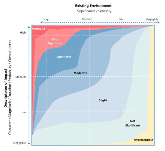
Environmental Impact Assessment Report (EIAR) Volume 2 of 4
Main Report

pumps, milestones, street lighting, statues, water troughs, railings, and protective bollards. These features all
contribute to the present-day character and uniqueness of an area by reflecting its historic past and are assessed
as part of the historic street scape within Chapter 16 (Architectural Heritage.

15.2.1.2 Approach

Recognising our unique sense of place in our urban and suburban environments, while respecting the individual
heritage assets was a key consideration during the development of the EIAR. A historic landscape character
(HLC) approach was undertaken where not only individual heritage assets were assessed but also how they
present in the landscape, their connectivity and their relationship to other heritage features. These were analysed
through mapping, documentary sources and site inspection.

By using different information sources and data sets, an understanding of the historic landscape character that
surrounds and is part of the Proposed Scheme has been developed. The modern landscape is a result of
numerous modifications over time. Understanding how these processes occur, and how they are represented in
today’s urban and suburban landscape, is critical in providing an insight into the layering and development of the
cultural heritage environment. It also facilitates an appreciation of an area’s unique character. The process is
concerned with identifying the dominant historic influences which have formed and define the present landscape.
By using existing data sets such as the RPS, RMP, NIAH for example, through the use of GIS and CAD, dominant
clusters of monuments, buildings and cultural heritage features begin to emerge.

Where sites are designated architectural heritage assets (NIAH / RPS), they are addressed in detail in Chapter
16 (Architectural Heritage). Where such sites are also RMP / SMR sites, they are assessed both in the present
Chapter and in Chapter 16 (Architectural Heritage).

Upstanding industrial heritage sites and examples of cultural heritage such as historic street furniture are
discussed in Chapter 16 (Architectural Heritage). Those sites which may survive below-ground are assessed in
the present Chapter, as potential archaeological sites.

Where cultural heritage assets are of interest from an archaeological, historical, or cultural interest, as well as
from an architectural heritage perspective, these are assessed both in the present Chapter and in Chapter 16
(Architectural Heritage).

Appendices associated with this chapter are detailed in Volume 4 of this EIAR and contain the following
information:
           •    Appendix A15.1 – Inventory of Archaeological and Cultural Heritage Sites;
           •    Appendix A15.2 – Glossary of Impacts and Assessment Methodology; and
           •    Appendix A15.3 – Relevant extracts from City and County Development Plans.

15.2.2 Study Area

The area examined for this study includes the full extent of the Proposed Scheme corridor. In order to inform the
likely significant impacts from an archaeological and cultural heritage perspective, a study area measuring 50m
on either side of the red line boundary for the Proposed Scheme was established (refer to Figure 15.1 in Volume
3 of this EIAR). This approach is tailored to the urban and suburban streetscape and is the accepted best practice
for linear infrastructural projects in built-up areas. The study area was assessed in order to identify known and
recorded archaeological and cultural heritage assets within it.

The study area was wide enough to assess the immediate archaeological and cultural heritage potential of the
Proposed Scheme. Professional judgement was used to determine where the study area should be extended to
consider archaeological sites / monuments or historic structures that lie beyond its boundaries. As required and
where appropriate, the relationship of structures, sites, monuments, and complexes that fall outside this study
area were considered and evaluated. The wider landscape or urban streetscape was also considered, to provide
an archaeological and historical context for the Proposed Scheme.

Clongriffin to City Centre Core Bus Corridor Scheme                                                Chapter 15 Page 3
Environmental Impact Assessment Report (EIAR) Volume 2 of 4
Main Report
For historic towns and villages that have a designated zone of archaeological potential (ZAP) on the published
RMP maps (Dúchas The Heritage Service 1998), these areas were considered in addition to the point data from
the online Historic Environment Viewer (HEV) provided by the National Monuments Service (NMS) (NMS 2020).
15.2.3 Relevant Guidelines, Policy and Legislation
The study was informed by relevant legislation, guidelines, policy, and advice notes, as listed below and in the
references, Section 15.7. Relevant extracts from the Dublin City Development Plan is contained in Appendix
A15.3 (Relevant extracts from City and County Development Plans) in Volume 4 of this EIAR.
• Architectural Heritage (National Inventory) and Historic Monuments (Miscellaneous Provisions)
Act, 1999;
• Code of Practice for Archaeology agreed between the Minister for Arts, Heritage, Regional, Rural
and Gaeltacht Affairs and Transport Infrastructure Ireland, 2017;
• Council of Europe (1985). Convention for the Protection of the Architectural Heritage of Europe
(ratified by Ireland 1997), ‘Granada Convention’;
• Council of Europe (1992). European Convention on the Protection of the Archaeological Heritage
(ratified by Ireland 1992), ‘Valetta Convention’;
• Council of Europe (2005). Framework Convention on the Value of Cultural Heritage for Society,
‘Faro Convention’;
• Department of Arts, Heritage, Gaeltacht and the Islands (DAHG) (1999). Framework and
Principles for the Protection of the Archaeological Heritage;
• Environmental Protection Agency (EPA) (2017). Revised Guidelines on the information to be
contained in Environmental Impact Statements, Draft August 2017;
• EPA (2015). Advice Notes for preparing Environmental Impact Statements, Draft September 2015;
• EPA (2002). Guidelines on the information to be contained in Environmental Impact Statements;
• EPA (2003). Advice Notes on Current Practice (in preparation of Environmental Impact
Statements);
• European Commission (2017). Environmental Impact Assessment of Projects – Guidance on the
Preparation of the Environmental Impact Assessment Report;
• Heritage Act, 1995 (as amended);
• Historic England (2017). The Setting of Heritage Assets, Historic Environment Good Practice
Advice in Planning Note 3 (Second Edition);
• ICOMOS (2011). Guidance on Heritage Impact Assessments for Cultural World Heritage
Properties;
• ICOMOS Xi’an Declaration on the Conservation of the Setting of Heritage Structures, Sites and
Areas, 2005;
• National Monuments Act, 1930 to 2014;
• National Roads Authority (NRA) (2005). Guidelines for the Assessment of Archaeological Heritage
Impact of National Road Schemes;
• Planning and Development Act 2000 (as amended);
• The Heritage Council (2013). Historic Landscape Characterisation in Ireland: Best Practice
Guidance; and
• The UNESCO World Heritage Convention, 1972.
15.2.4 Data Collection and Collation
A detailed evaluation of the archaeological and cultural heritage resource took place, comprising a desk study of
published and unpublished documentary and cartographic sources, supported by a field survey.
15.2.4.1 Desk Study
The desk study availed of the following sources:
• The National Monuments, Preservation Orders and Register of Historic Monuments lists, sourced
directly from the DHLGH;
• RMP and SMR: The SMR, as revised in the light of fieldwork, formed the basis for the establishment
of the statutory RMP in 1994 (RMP; pursuant to Section 12 of the National Monuments
Clongriffin to City Centre Core Bus Corridor Scheme Chapter 15 Page 4Environmental Impact Assessment Report (EIAR) Volume 2 of 4
Main Report
(Amendment) Act, as amended in 1994). The RMP records known upstanding archaeological
monuments, their original location (in cases of destroyed monuments) and the position of possible
sites identified as cropmarks on vertical aerial photographs. The information held in the RMP files
is read in conjunction with published constraint maps. Archaeological sites identified since 1994
have been added to the non-statutory SMR database of the Archaeological Survey of Ireland (NMS,
DHLGH), which is available online (NMS 2020) and includes both RMP and SMR sites. Those sites
designated as SMR sites have not yet been added to the statutory record, but are scheduled for
inclusion in the next revision of the RMP;
• The topographical files of the National Museum of Ireland (NMI 2020);
• Cartographic sources, comprising pre-19th century historic maps and various editions of the
Ordnance Survey (OS) six-inch maps, 25-inch maps and five-foot plans;
• Excavations Bulletins and Excavations Database (Excavations 1970 to 2020);
• Dublin County Archaeology GIS (The Heritage Council 2015);
• Dublin City Council’s (DCC) Dublin City Development Plan 2016 - 2022 (DCC 2016);
• Conservation Plan Dublin City Walls and Defences (DCC 2004)
• NIAH, Building Survey and Garden Survey, DHLGH (NIAH 2020);
• Dublin City Industrial Heritage Record (DCIHR) (DCC 2003 to 2009);
• Placenames Database of Ireland (Logainm 2020);
• Aerial imagery online: Google Earth 2001 to 2018 (Google Earth Pro 2001 to 2018), Bing 2013 (Bing
2020) and Ordnance Survey Ireland (OSI) 1995; 2000; 2005 to 2012 (OSI 2020); and
• Other documentary sources (as listed in the references, Section 15.7).
15.2.4.2 Field Survey
A walkover survey was undertaken along the extent of the Proposed Scheme, including offline elements, on 12
June 2020. Recorded archaeological sites or monuments within the study area (and relevant monuments outside
of it) were inspected. The survey took cognisance of upstanding industrial heritage sites listed in the DCIHR (DCC
2003 to 2009) that are situated within or adjacent to the Proposed Scheme. It also sought to identify any potential
archaeological sites, as well as features of industrial or cultural heritage interest within the study area for the
Proposed Scheme that contribute to the historic character of the area.
15.2.4.3 Mapping
The locations for all archaeological and cultural heritage assets identified in the course of the assessment have
been mapped and are shown on Figure 15.1 in Volume 3 of this EIAR. The coordinates for each asset are provided
in Irish Transverse Mercator (ITM) in the inventory of archaeological and cultural heritage sites in Appendix A15.1
(Inventory of Archaeological and Cultural Heritage Sites) in Volume 4 of this EIAR.
15.2.5 Appraisal Method for the Assessment of Impacts
Archaeological and cultural heritage sites are considered to be a non-renewable resource and cultural heritage
material assets are generally considered to be location sensitive. In this context, any change to their environment,
such as construction activity and ground disturbance works, could adversely affect these sites. The likely
significance of all effects is determined in consideration of the magnitude of the impact and the baseline rating
upon which the impact has an effect (i.e. the sensitivity or value of the cultural heritage asset). Having assessed
the potential magnitude of impact with respect to the sensitivity / value of the asset (Table 15.1, Table 15.2 and
Image 15.1), the overall significance of the effect is then classified as not significant, imperceptible, slight,
moderate, significant, very significant, or profound (Table 15.3).
A glossary of impact assessment terms, including the criteria for the assessment of effect significance, is
contained in Appendix A15.2 (Glossary of Impacts and Assessment Methodology) in Volume 4 of this EIAR.
Clongriffin to City Centre Core Bus Corridor Scheme Chapter 15 Page 5Environmental Impact Assessment Report (EIAR) Volume 2 of 4
Main Report
Table 15.1: Significance / Sensitivity Criteria
Sensitivity / Criteria
Significance
High Sites of international significance: World Heritage Sites.
National Monuments.
Protected Structures (assessed by the NIAH to be of international and national importance), where these are also
National Monuments.
Undesignated archaeological and cultural heritage sites.
Medium Recorded Monuments (RMP sites & SMR sites scheduled for inclusion in the next revision of the RMP)
Protected Structures / NIAH sites (assessed by the NIAH to be of regional importance), where these are also
Recorded Monuments.
Newly identified archaeological sites, confirmed through archaeological investigation, to be added to the SMR.
Undesignated archaeological and cultural heritage sites.
Low Sites listed in the Dublin City Industrial Heritage Record (DCIHR) and National Inventory of Architectural Heritage
(NIAH) Building for which there are no upstanding remains.
Undisturbed greenfield areas and riverine environs, which have an inherent archaeological potential.
Undesignated archaeological and cultural heritage sites.
Negligible Assets with very little or no surviving archaeological and / or cultural heritage interest.
Table 15.2: Magnitude of Impact Criteria
Impact Criteria
Magnitude
High These impacts arise where an archaeological / cultural heritage asset is completely and irreversibly destroyed by a
proposed development. A change such that the value of the asset is totally altered or destroyed, leading to a complete
loss of character, integrity and data about the site.
Medium An impact which, by its magnitude, duration or intensity alters an important / significant aspect of the environment. An impact
like this would be where an archaeological / cultural heritage asset would be impacted upon leading to a significant loss of
character, integrity and data about the site.
Or an impact which by its magnitude results in the partial loss of a historic structure (including fabric loss or alteration) or grounds
including the part removal of buildings or features or part removal of demesne land (e.g. severance, visual intrusion or
degradation of setting and amenity).
A permanent positive impact that enhances or restores the character and / or setting of a cultural heritage site or
upstanding archaeological heritage site in a clearly noticeable manner.
Low A low impact arises where a change to the site is proposed which though noticeable is not such that the archaeological / cultural
heritage character / integrity of the site is significantly compromised, and where there is no significant loss of data about the site.
A positive impact that results in partial enhancement of the character and / or setting of a cultural heritage site or
upstanding archaeological heritage site in the medium to long-term.
Negligible An impact which causes very minor changes in the character of the environment and does not directly impact an archaeological
/ cultural heritage asset or affect the appreciation or significance of the asset. There would be very minor changes to the
character and integrity of the asset and no loss of data about the site.
Table 15.3: Defining Significance of Impacts
Impact Definition
Imperceptible An impact capable of measurement but without noticeable consequences.
Not Significant An impact which causes noticeable changes in the character of the environment but without significant consequences.
Slight An impact which causes minor changes in the character of the environment and does not affect an archaeological /
cultural heritage asset in a moderate or significant manner.
Moderate A moderate impact arises where a change to the site is proposed which though noticeable, does not lead to a
significant loss of character, integrity and data about the archaeological / cultural heritage asset.
Significant An impact which, by its magnitude, duration or intensity, alters an important aspect of the environment. An impact like
this would be where part or all of a site would be permanently impacted upon, leading to a significant loss of character,
integrity and data about the archaeological / cultural heritage asset.
Very An impact which, by its character, magnitude, duration or intensity significantly alters most of a sensitive aspect of the
Significant environment.
Profound Applies where mitigation would be unlikely to remove adverse impacts. Reserved for adverse, negative impacts only.
These impacts arise where an archaeological / cultural heritage asset is completely and irreversibly destroyed by a
proposed development.
Clongriffin to City Centre Core Bus Corridor Scheme Chapter 15 Page 6Environmental Impact Assessment Report (EIAR) Volume 2 of 4 Main Report Image 15.1: Description of Impacts from the Draft EPA Revised Guidelines on Information to be Contained in EIS (EPA 2015) Clongriffin to City Centre Core Bus Corridor Scheme Chapter 15 Page 7
Environmental Impact Assessment Report (EIAR) Volume 2 of 4
Main Report

15.3       Baseline Environment
15.3.1 Archaeological and Historical Background

15.3.1.1 The River Mayne

The Proposed Scheme will commence south of the River Mayne, at Mayne River Avenue. The presence of known
archaeological monuments in its vicinity suggests that this river was a focus of medieval settlement (e.g. at nearby
Balgriffin Park, a country house that once stood to the north of Belmayne) and presumably also earlier activity.
The river and the place-name of Mayne is referenced in the Dindshenchas, the early Irish text that recounts the
origins of place-names and traditions concerning events and characters associated with them. Mayne owes its
origins to the son of Maedhbh and Ailill of Connacht (known as Maine or Cichmaine), who is said to have been
killed here by fishermen. His burial ground is described as being at the northern end of Inbhearr Cichmaine, the
inlet or bay of Cichmaine, where he was killed (i.e. the northern end of present Portmarnock Bay; Morris 1939
cited in RMP file) (NMS 2020).

Archaeological investigations in the surrounding area point to a considerable amount of activity here from the late
Neolithic and Bronze Age, through the Iron Age and into the early medieval period, producing evidence for a
variety of sites, such as pits and hearths associated with domestic and craft / quasi-industrial activities, ritual sites
(a ring-ditch and an isolated cremation) and an early medieval ringfort. Two recorded burnt mounds were also
excavated c. 650m to the north-east of the Proposed Scheme (RMP DU015-096, -097). The presence of burnt
mounds or fulachta fia is often indicative of Bronze Age seasonal communal activity in river valleys, lakeshores
and boggy ground; scientific dating of a randomly excavated sample has shown a predominance of second
millennium BC dates for their use (Brindley and Lanting 1990). There is no agreement that burnt mounds were
cooking places, although it does seem that they were used to prepare large quantities of boiling water and that
they were repeatedly used, resulting in a large mound of heat shattered stones accumulating. Other theories for
the use of these sites include bathing, saunas or sweathouses, washing or dyeing large quantities of cloth, the
preparation of leather and brewing.

15.3.1.2 Coolock

Coolock is within the bounds of Fingal, the regional name applied to the northern half of County Dublin. The name
Fingal is used to denote the district into which the Vikings led predatory excursions. In the 9th century AD, a colony
of Ostmen, or Northmen, established themselves in Dublin, ultimately settling in the tract extending northwards
along the coast. This area became known as Fine Gall, or the territory of the Galls, or strangers. According to the
poet John O’Dugan, Fingal came under the rule of Mac Gillamocholmog, who controlled the lands south of Dublin
before the arrival of the Anglo-Normans in the late 12th century (Swan 1987). The Baron de Nugent, an accomplice
of Strongbow, was rewarded with the lands, tithes, and taxes of Coolock barony prior to 1207; evidence suggests
that he had firmly established his family here by the turn of the 13th century (Ibid.).

Early medieval activity in the wider area is indicated by the ecclesiastical site at the present mid-18th century
church of St John the Evangelist on Tonlegee Road, c. 145m south-east of the Proposed Scheme (RMP DU015-
076). The church occupies an early ecclesiastical site associated with St Brendan of Clonfert (Appleyard 1985).
Excavations in 1990 exposed portion of an earlier wall and a section of outer fosse and inner bank on the south
side of the site (Swan 1991). Finds included a bronze penannular brooch, a small lead ingot and worked antler.
Other elements of the early ecclesiastical site include a plain granite cross and a millstone of a horizontal watermill
found in the grounds of the churchyard. More recent archaeological investigations have uncovered additional
sections of the ecclesiastical enclosure to the north of the site, which indicate that it was oval and orientated north-
east / south-west (Excavations 2018).

Appleyard mentions a chapel in Coolock village c. 1710, on the site of St Brendan’s Church (RMP DU015-084)
(Appleyard 1985). The green triangular patch at the junction of Oldtown lane with Coolock Lane (where Beechpark
Avenue joins Oscar Traynor Road) was known as ‘the Chapel Bank’ (Appleyard 1985).

Coolock remained a small village until the 1950s, when it began to be developed as part of Dublin's suburbs, with
lands around the village being further developed over time, notably Bonnybrook and Kilmore West. In 1933
production began at Cadbury’s first Irish factory at Ossory Road, at North Strand in Dublin. In 1939 a second

Clongriffin to City Centre Core Bus Corridor Scheme                                                     Chapter 15 Page 8
Environmental Impact Assessment Report (EIAR) Volume 2 of 4
Main Report

Cadbury’s factory was constructed on Dublin’s East Wall Road. In 1964, the existing Cadbury’s factory was
opened in Coolock.

A mound (RMP DU015-074) is located at the south-eastern end of the Cadbury Factory grounds in Coolock, c.
30m west of the Proposed Scheme. This grass-covered tree-topped mound measures 20m in diameter and is
over 3m high. Even though it is marked as a ‘Moat’ on the first and second edition OS maps, it is too small to be
a defensive Norman feature. A mound of this type is more likely to represent a prehistoric burial site and probably
dated from the Neolithic or Bronze Age. It has been suggested that this may be a Linkardstown-type burial
(Stanley 2011), similar to those found elsewhere in Dublin (e.g. one excavated at Drimnagh in 1938 and another
discovered in the Phoenix Park in 1838). Archaeological testing in a temporary car park adjacent to the mound
identified ditches of probable Bronze Age date (Section 15.3.3.4). The proximity of the ditches to the mound would
suggest they are broadly contemporary with it, strengthening the likelihood that this is a prehistoric burial mound,
possibly a barrow (Excavations 2012).

15.3.1.3 Medieval settlement at Artane

During the Anglo-Norman period the area around Artane formed part of the estate owned by the de Hollywoods,
who also owned lands in Dublin, Meath and Wexford. Their residence was Artane Castle, the site of which is now
a recorded monument c. 225m north-west of the Proposed Scheme (RMP DU014-073001). The remains of an
associated church and graveyard are recorded to the south of the castle site (RMP DU014-073002 and -073003).
The first edition OS six-inch map (1843) shows the site of ‘Artaine Castle’ in the grounds of a house of the same
name (OSI 2020) – refer to Image 15.2. The grounds of Castle house as depicted on the historic map extend
south-eastwards to meet the old Dublin to Malahide Road, with a secondary entrance and gate lodge once
situated at the junction of the present St David’s Wood and R107 Malahide Road. The principal entrance to the
house at that time was off the Kilmore Road (then known as Skelly’s Lane), just south-east of the present Artane
Shopping Centre. Rocque’s map of 1760 (Ferguson 1998) shows the lands prior to the construction of the new
house in 1825 and the development of the demesne – refer to Image 15.3. On this earlier map the entrance to
the castle bawn is also off the Kilmore Road, between the 19th century entrance and the church, with a path
curving northwards to the church, also from the junction of the present St David’s Wood and R107 Malahide Road.
Archaeological investigations on the opposite side of Kilmore Road in 2015 identified a medieval ditch that was
backfilled around the 14th century. It ran east of and parallel to Kilmore Road suggesting that it defined the route
of an ancient road that provided access to the castle and church of Artane (Excavations 2015).

Clongriffin to City Centre Core Bus Corridor Scheme                                                 Chapter 15 Page 9
Environmental Impact Assessment Report (EIAR) Volume 2 of 4
Main Report

Image 15.2: OS First Edition Six-Inch Map (1843), Showing Grounds of Artane Castle House and Site of Artane Castle (RMP
DU014-073001) (OSI 2020)

Image 15.3: Rocque’s Map of Dublin, 1760, Showing Artane Castle and Church (Ferguson 1998)

This castle is mentioned in the Civil survey (1654 to 1656) in the possession of ‘Nicholas Hollywood of Artaine’
(Simington 1945). The Hollywood’s were in residence here in the 16th century when the Archbishop and
chancellor, John Allen, was assassinated on the orders of Thomas Fitzgerald (better known as Silken Thomas).
The Archbishop had helped spread rumours that the earl of Kildare, Fitzgerald’s father, had been executed in the

Clongriffin to City Centre Core Bus Corridor Scheme                                                  Chapter 15 Page 10
Environmental Impact Assessment Report (EIAR) Volume 2 of 4
Main Report

Tower of London (Ball 1905). Artane Castle became the focus once again during the rebellion of 1641, when the
castle was commandeered by Luke Netterville and his army under the agreement of Christopher Hollywood. This
resulted in the outlawing of Christopher and Nicholas Hollywood and the confiscation of much of their lands (Ball
1905). The castle remained in the hands of the Hollywood family until the 19th century when it was levelled in
1825 and the stones used to build a new house. Purchased by the Christian Brothers in 1875, it became an
orphanage developing a trade school (Artane Industrial School, now St David's Secondary school) which was
active for much of the 20th century (De Courcy 1996).

15.3.1.4 Malahide Road, Griffith Avenue and Marino: Early 20th century residential development

Throughout the medieval period the lands in the modern townlands of Marino, Donnycarney and Clontarf formed
a portion of the All Hallows Estate, attached to the monastery which occupied the present site of Trinity College
Dublin. It was from these lands that the priory was provided with its chief supply of grain (Ball 1905).

A large-scale building scheme at Marino was first suggested in 1910. A preliminary layout plan involved 96 acres,
including the grounds of Marino House and additional land from the Christian Brothers Seminary (McManus 2002).
The area lay on the outskirts of the City Centre and was largely occupied by the extensive demesne associated
with Marino House. As many as 1100 houses were planned, along with 12.5 acres of allotments. Existing trees
and woodland were to be incorporated into the layout wherever possible. Dublin Corporation took control of the
land in 1915, which had been used as allotments by the Land Cultivation Committee for a number of years. In
October 1919, the Municipal Council approved a plan of 600 houses on a 50-acre site, at a cost of approximately
£695 per house (Ibid.). The City Architect later amended the plan to 530 houses. In 1922 a Housing Committee
report noted that the Marino Scheme had not proceeded because of the political situation (i.e. the upheaval of the
Civil War). The Committee took the opportunity to include additional land, so that the original 50-acre site was
increased by a further 76 acres. Negotiations were underway by the following year to purchase the additional land
which extended westward from the 50-acre site to Philipsburgh Avenue.

Image 15.4: OS First Edition Six-Inch Map (1843), Showing Area Around Marino in the 19th Century (OSI 2020)

Clongriffin to City Centre Core Bus Corridor Scheme                                                      Chapter 15 Page 11
Environmental Impact Assessment Report (EIAR) Volume 2 of 4
Main Report

Building on the proposed new thoroughfare on the northern boundary (Griffith Avenue) was deferred until a future
date when money would be available to construct ‘a superior class of dwelling within the prescribed limit’
(McManus 2002). After leaving the main frontages at Malahide Road, Griffith Avenue, Philipsburgh Avenue and
Marino Mart, it was planned to erect 428 houses in two phases; 852 houses were eventually completed. The
north-eastern boundary of the Marino scheme was formed by the so-called ‘100-foot road’, and leases for houses
on this road, which became known as Griffith Avenue, were first granted in 1927. The Griffith Avenue frontage
was built up gradually by a number of different interests, although in a manner allowing the Corporation to control
the size and quality of houses being built. The progression of the suburban development around Marino can be
seen on the historic mapping depicted in Image 15.4 and Image 15.5. The encroachment into the former
demesne lands was not restricted to densely planned housing, but also included schools and churches.

Image 15.5: OS Revised Edition Six-Inch Map (1935-38), Showing Suburban Development in Marino by the Mid-20th Century (OSI
2020)

15.3.1.5 Marino Casino

The estate at Marino was established during the latter half of the 18th century by James Caulfield, 1st Earl of
Charlemont. His step-father, Thomas Adderley of Innishannon, had acquired the estate on his behalf while
Charlemont was resident in Rome and presented the estate and Donnycarney House (later renamed Marino
House) as a gift on his return to Ireland in 1755. The house in Donnycarney was already in existence when
Adderley purchased the property and is depicted on an estate map of 1704. In c.1750 Adderley built a new
mansion for Lord Charlemont to the south-west of the original house, in the lower portion of the estate, closer to
the sea, as depicted on Rocque’s map of 1760 (Image 15.6). This new house, also named Donnycarney House,
was subsequently re-named Marino House by Charlemont after he had taken ownership of the property; both

Clongriffin to City Centre Core Bus Corridor Scheme                                                     Chapter 15 Page 12
Environmental Impact Assessment Report (EIAR) Volume 2 of 4
Main Report

names – Marino and Donnycarney – are used on Rocque’s map, reflecting the very recent name change.
Charlemont immediately set about establishing the estate as an important seat and began to undertake a series
of improvements, the most notable of which was the erection of the Casino (or Temple) to the north of Marino
House (Howley Hayes Architects 2009).

The Casino is both a national monument and a protected structure (NM 302, RMP DU018-144; RPS 4858), and
an Architectural Area of Conservation has been designated around it (Chapter 16 (Architectural Heritage)). The
building, which is effectively a garden pavilion, is located c. 180m west of the Proposed Scheme on Malahide
Road. It was designed by Scottish architect Sir William Chambers for James Caulfield, the 1st Earl of Charlemont,
beginning in the 1750s and finishing around 1775. The name is derived from Italian Casino Marino which
translates literally as ‘the little house by the small sea’. Widely regarded as the most important Neo-Classical
building in Ireland, it is actually quite small, measuring only 15m square to the outer columns. In plan, it takes the
form of a Greek cross with a pair of columns framing each projecting elevation. Seen from the outside, the building
has the appearance of a single roomed structure, with a large panelled door on the north elevation and a single
large window on each of the other elevations. This is all an illusion however as it actually contains 16 rooms on
three floors. Only two of the panels in the doors open to allow an entrance, and the panes in the windows are
subtly curved, disguising the partitioning which allows what looks like a single window to serve several rooms.
The interior includes a basement level with a kitchen and rooms and a State Bedroom. It contains some very fine
plasterwork ceilings and some elaborate hardwood parquet floors. Originally the Casino was linked to Marino
House by a tunnel (DU018-144), although this is now blocked off (NMS 2020).

Image 15.6: Rocque’s Map of County Dublin, 1760, Showing Area Around Marino in the 18th Century (Ferguson 1998)

The Casino was positioned in a part of the park which consisted of open, light-filled pasture grazed by flocks of
sheep. After Caulfield’s death it fell into disuse and eventually it was taken into state ownership as a national
monument in the 1930s; the Office of Public Works restored the building under the direction of H.G. Leask (Reilly
2013).

Clongriffin to City Centre Core Bus Corridor Scheme                                                   Chapter 15 Page 13
Environmental Impact Assessment Report (EIAR) Volume 2 of 4
Main Report
15.3.1.6 Scurloges Bridge, Malahide Road
The present Donnycarney Bridge, built in 1896, replaced an earlier structure straddling the River Donnycarney.
The older bridge is depicted on Rocque’s 18th century map (Image 15.6) and on the 1843 OS map, on which it is
named ‘Scurloges Br.’ (RMP DU018-006) (Image 15.7). The small red-brick Donnycarney Bridge replaced ‘an
ancient stone structure’ named Scurloges Bridge (a name by which it had been known for centuries) (Wren 1983).
Wren suggests that the name is a corruption of the townland name Silloge, where River Donnycarney has its
source. He also records that there was an ancient right of way on the northern side of the old bridge, which led
‘through the lands of Puckstown to the great north road’ (Ibid.).
Image 15.7: OS First Edition Six-Inch Map (1843), Showing Scurloges Bridge (OSI 2020)
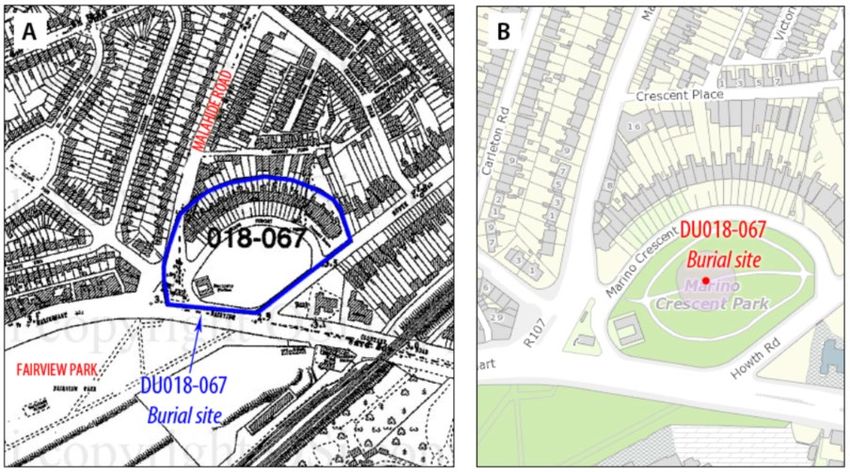
15.3.1.7 Burial at Marino Crescent
Marino Crescent (Image 15.4), built in 1792, is said to have been erected by Charles Ffolliott, who, having some
disagreement with Lord Charlemont, built this row of houses in order to shut out the view of the sea from Marino
House (Joyce 1921). Human remains were unearthed during the construction of a crescent of Georgian houses
c. 1792 (RMP DU018-067). An account of the discovery is provided in a paper in the Dublin Historical Record
(Wren1983):
‘Marino Crescent at the bottom of Malahide Road, with the tall Georgian houses and which has been
described as the Bath of Ireland, was built around 1792 by Charles Ffolliot an Aungier Street painting
contractor. These houses, it is said, were once known locally as Spite Crescent due to a dispute between
Lord Charlemont and Ffolliot, the latter erected these tall buildings to shut out the view of the bay from
Marino House. Charlemont in an attempt to prevent Ffolliot from bringing materials to the site, increased
the toll charges at the gate under his control, but the wily painter had his building supplies conveyed by
barge across the bay. Many human bones were unearthed here when the foundations for the houses
were being excavated, perhaps the remains of some of the fallen of the Battle of Clontarf.’
15.3.1.8 Clontarf Road / Marino Mart
The name Clontarf derives from the Irish Cluain Tarbh, meaning ‘the meadow of the Bull’ (Joyce 1921). It is said
to be so-called because of the rumbling noise made by the sea as it rolled over the sandbanks in Dublin Bay (now
lessened by the presence of the North and South Walls). This part of coastal Dublin was within the district of
Cianachta and later of Fingal. A relic of the old Cianachta remains in the name of the River Naniken (Abhainn na
gCian), which flows through St Anne's Park. Around 550 AD, a church was founded by the Abbot of Bangor, St
Clongriffin to City Centre Core Bus Corridor Scheme Chapter 15 Page 14Environmental Impact Assessment Report (EIAR) Volume 2 of 4 Main Report Comgall, indicating early Christian activity here. Clontarf also has a significant medieval history, with a castle at Clontarf erected by Adam de Pheope as part of the Anglo-Norman settlements in North Dublin. The area is probably most frequently associated with the Battle of Clontarf which took place on April 23rd 1014. At the fishing weir of Clontarf, Brian Boru, High King of Ireland, and his allies engaged the armies of rebellious Leinstermen, the Hiberno-Norse of Dublin and Danish Vikings from as far afield as Orkney. The battle resulted in the defeat of the Danish Vikings and the death of Brian Boru. The battle was mainly fought along the banks of the River Tolka from Glasnevin to Ballybough. However, it was at the strand at Clontarf that the Vikings had beached their boats, and this was the location of the final confrontation. During the 18th and 19th centuries, the main activities at Clontarf were fishing, farming, and related industry. In his evidence to a commission in 1831, John Barlow of Sybil Hill mentions that Clontarf was the property of the Vernons and that while the farmers who held land under them were nearly all Protestants, the majority of people were labourers who lived in thatched mud cabins with little or no furniture. The area referred to as ‘The Sheds’, adjoining which stood the old village of Clontarf, originated with some sheds or stages erected to facilitate the curing and drying of fish (Ball 1905). As a result of the construction of the Dublin and Drogheda railway in 1844, the area underwent a period of significant growth. Even greater development followed the introduction of the horse-drawn tram service from Nelson’s Pillar to Dollymount in 1880 (Image 15.8). Image 15.8: OS Revised Edition 25-Inch Map (1906-09), Showing Tramway Along Marino Mart (OSI 2020) The tramway travelled along Clontarf Road, Fairview, and on down North Strand Road and Amiens Street, providing an efficient transport link into the City Centre. An urban public transport system was introduced in 1872 when horse-drawn trams first began to appear on the City Centre streets. Tram tracks, which were laid on public roads, had a groove to position the wheel flange so that the upper face of the track was unobtrusive, running flush Clongriffin to City Centre Core Bus Corridor Scheme Chapter 15 Page 15
Environmental Impact Assessment Report (EIAR) Volume 2 of 4
Main Report

with the road surface. Most of the services ran within the City Centre and near suburbs, with the majority of major
suburbs served. By 1878 three separate companies were in operation in Dublin, amalgamating three years later
to form the Dublin United Tramway Company (DUTC) (Corcoran 2008). The last suburban horse-tram route
opened by the DUTC was in 1896, which ran along the South Circular Road to Dolphin’s Barn, and by 1901 there
was near-full electrification across the system, with power being transmitted to the tramcar via overhead cables
supported by tram poles (Ibid.). At its peak, the system was heavily used, with over 60 miles of active line, and
was profitable and advanced in both technology and passenger facilities (Ibid.). By the early 20th century the
Dublin tramway system was seen as the most efficient of its type in Europe, and had the seventh largest electric
tramway network in the world. Heavy usage lasted from the late 19th century into the 1920s (Carrig 2006). The
decline of the trams accelerated in the 1940s and the last trams in the City Centre ran on 9 July 1949.

Housing was built to serve the new commuters, initially in the area west of Malahide Road with developments
extending along (and back from) Marino Mart and Clontarf Road (Image 15.9); this was followed by further housing
on the east side of Malahide Road, north of Marino Mart, as part of the large-scale development of the 1920s and
1930s. In 1900 Clontarf was incorporated into the City Centre of Dublin. In 1931, the Dublin Port and Docks Board
began a reclamation scheme which, when completed, provided an improved roadway and promenade.

Image 15.9: OS First Edition 25-Inch Map (1888-1913), Showing Residential Development West of Malahide Road (OSI 2020)

15.3.1.9 Fairview Park and River Tolka

The name of the parish of Fairview is frequently associated with an earlier parish name, Clonturk, which takes its
name from a townland on the road to Swords. Early forms of the place name from Latin documents suggest that
the original name was Ceann Torc, 'headland of the boars'. The element cluain had replaced ceann by the middle
of the 16th century, perhaps influenced by the more famous placename Cluain Tarbh / Clontarf (Logainm 2020).

The area of modern-day Fairview began to develop with the construction of Annesley Bridge in 1797. Rocque’s
map of 1760 clearly shows that Ballybough Bridge was previously the only means of crossing the River Tolka in
this area (Image 15.10). Rocque’s map names the Tolka as the ‘Ballybough River’ (Ferguson 1998). The River

Clongriffin to City Centre Core Bus Corridor Scheme                                                     Chapter 15 Page 16
Environmental Impact Assessment Report (EIAR) Volume 2 of 4
Main Report
Tolka (in Irish An Tulcha, meaning the flood) is one of Dublin’s three main rivers (along with the River Liffey and
the Dodder). Annesley Bridge is located at what was originally the mouth of the river, but reclamation has resulted
in the Tolka flowing immediately south of Fairview Park before entering in to the sea north of East Wall Road.
Fairview Park was originally tidal mud flats and was used for municipal land-fill in the early 1900s. This is
evidenced by the 18th and 19th century pottery revealed when groundworks in the park were monitored by Dr Ruth
Johnson, Dublin City Archaeologist (Walsh 2013 pers. comm.). The park was developed in the late 1920s.
Image 15.10: Rocque’s Map of County Dublin, 1760, Showing Marino Mart and Fairview in the 18th Century Prior to Land
Reclamation (Ferguson 1998)
15.3.2 Archaeological Heritage: Mayne River Avenue to Gracefield Road - Malahide
Road
15.3.2.1 National Monuments
There are no national monuments or sites under preservation order within or in the vicinity of this section of the
Proposed Scheme.
15.3.2.2 Recorded Archaeological Monuments (RMP / SMR Sites)
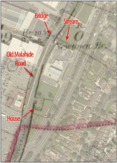
There are no RMP / SMR sites within this section of the Proposed Scheme and just one within c. 50m (Table
15.4). The mound in the grounds of Cadbury’s Factory in Coolock has an above-ground presence (RMP DU015-
074; Figure 15.1 Sheet 4 of 9 in Volume 3 of this EIAR). The ZAP for the RMP site is contained within the factory
grounds, which are bounded by the Old Malahide Road. The tree-covered mound is located c. 30m north-west of
the boundary railings and the edge of the Proposed Scheme. The mound was labelled ‘Moat’ on the first edition
1843 OS six-inch map (OSI 2020), suggesting it was thought to be an Anglo-Norman motte. However, its small
size makes this unlikely and may instead indicate a prehistoric burial mound. It has been suggested that this may
be a Linkardstown-type burial (Stanley 2011), similar to those found elsewhere in Dublin. Previous archaeological
investigations in the wider vicinity of the mound, within the grounds of the factory have identified no archaeological
material, however archaeological testing in a temporary car park adjacent to the mound identified ditches of
probable Bronze Age date (Section 15.3.3.4). The proximity of the ditches to the mound would suggest they are
broadly contemporary with it, strengthening the likelihood that this is a prehistoric burial mound, possibly a barrow.
Clongriffin to City Centre Core Bus Corridor Scheme Chapter 15 Page 17Environmental Impact Assessment Report (EIAR) Volume 2 of 4 Main Report Entries relating to the RMP / SMR sites in Table 15.4 are contained in Appendix A15.1 (Inventory of Archaeological and Cultural Heritage Sites) in Volume 4 of this EIAR. Table 15.4: RMP / SMR Sites Within c. 50m of the Proposed Scheme: Mayne River Avenue to Gracefield Road - Malahide Road Section ID No. Name / Type Townland / Street Address ITM DU015-074 Mound Grounds of Cadbury’s Factory, Old Malahide Rd, Coolock 719918, 739388 15.3.2.3 Topographical Files, National Museum of Ireland No stray finds are recorded along or in the vicinity of this section of the Proposed Scheme. 15.3.2.4 Previous Archaeological Investigations Archaeological monitoring was undertaken of the enabling works for construction of the Clarehall Shopping Centre in 2001 (Licence 01E1073). Nothing of archaeological interest was identified within the 27 hectare site (Excavations 2002). Archaeological monitoring took place in 2012 / 2013 as part of the Santry to East Wall Pipeline Replacement Project (Walsh 2013). Sections of the pipeline route coincide with the Proposed Scheme, running along the Malahide Road from outside the Cadbury Factory at Coolock. Specific monitoring of the excavation of the Santry to East Wall pipeline trench along the Malahide Road was not carried out in the vicinity of the recorded mound in the grounds of the Cadbury Factory (RMP DU015-074), however, several archaeological investigations have taken place within the factory grounds. Archaeological testing was carried out in an area to the south of the mound (Licence 94E044) (Excavations 1994). Further testing was carried out ahead of the construction of an above- ground gas installation located to the west of the monument (Licence 00E0703). No features or finds were recorded during either of these assessments (Excavations 2000). Another archaeological assessment (Licence 10E122) was carried out c. 115m to the north / north-west of the mound. Testing established that the proposed area of development was highly disturbed and no features or finds of archaeological significance were identified in the test trenches. Excavation works for the insertion of a lift pit to the south of the existing factory building were also inspected during these investigations. The ground was found to have been heavily disturbed during the insertion of services in modern times. No archaeological material was uncovered (McQuade 2010). This was also the case when the excavation of a pipeline trench in proximity to the mound was monitored in 2012, which identified made ground probably associated with the modern landscaping of the grounds around the factory (Excavations 2012). Also in the wider vicinity of the mound, archaeological monitoring of topsoil stripping in the rear garden of 68 and 69 Brookville Park found nothing of archaeological interest (Licence 17E0233; Excavations 2017a). In contrast, an area closer to the mound revealed prehistoric ditches, of probable Bronze Age date. During the course of improvement works on the factory site, a temporary car park, which was exempt from planning, was created by stripping topsoil from an area located c. 3m to 4m to the west of the mound. The NMS was not given advance notice of the works and there was no archaeologist present to monitor topsoil-stripping. When the NMS became aware of the situation, they requested an assessment in order to determine whether the works had impacted on archaeological remains. Two test trenches were excavated in the area that had been stripped of topsoil and the stockpiled soil removed from the area was inspected (Licence 10E122). Three ditches were identified in the test trenches, with the finds recovered indicating a probable Bronze Age date. Their proximity to the mound would suggest they are broadly contemporary with it. The area available for test excavation was limited somewhat because the car park was still in use and it is considered likely that other features survive subsurface below the hard core beyond the trenches (Excavations 2012). Archaeological testing took place at a decommissioned Shell Garage, at the junction of Coolock Main Street and the Malahide Road, due to proximity to the recorded chapel site in Coolock village (DU015-084, c. 65m north- west of the Proposed Scheme). No archaeological deposits or features were uncovered within the undisturbed / uncontaminated areas of the site (Keith 2007). Other archaeological investigations in the vicinity of Main Street (to the west and south-west) have identified medieval and post-medieval activity. A 19th century laneway leading Clongriffin to City Centre Core Bus Corridor Scheme Chapter 15 Page 18
You can also read