102 Flagler Dr - Guest House Renovations - Aerial from Palm Beach County Property Appraiser website showing subject property - accessed ...
←
→
Page content transcription
If your browser does not render page correctly, please read the page content below
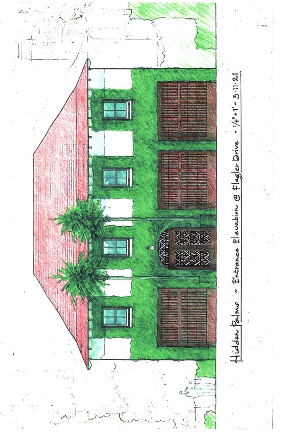
102 Flagler Dr. – Guest House Renovations
                 A-036-2021

                                Aerial from Palm Beach County Property
                                Appraiser website showing subject
                                property – accessed 02.16.2021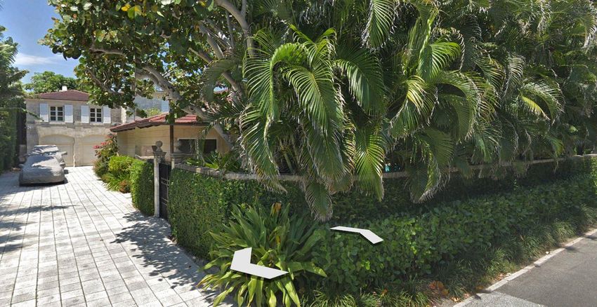
131 Barton Ave                   102 Flagler Dr. – subject property
                             New Pedestrian entry at open garage bay

                       Images accessed from Google Earth
                       02.16.2021

   126 S. Ocean Blvd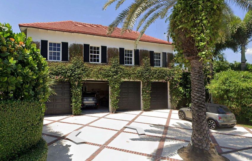
Design inspiration for new entry gate.
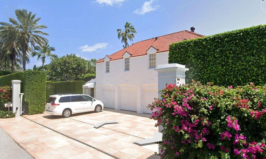

Proposed brushed aluminum gate
with laser-cut grilles set
in mahogany frames
(6’-5” wide x 6’-11” high, plus
transom)
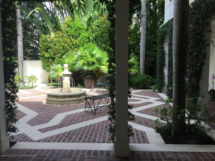
Existing guest house                                Current courtyard Entry

                                                                              Images accessed from
Courtyard with guest house
                                                                              Realtor.com 02.16.2021
                             Courtyard- no change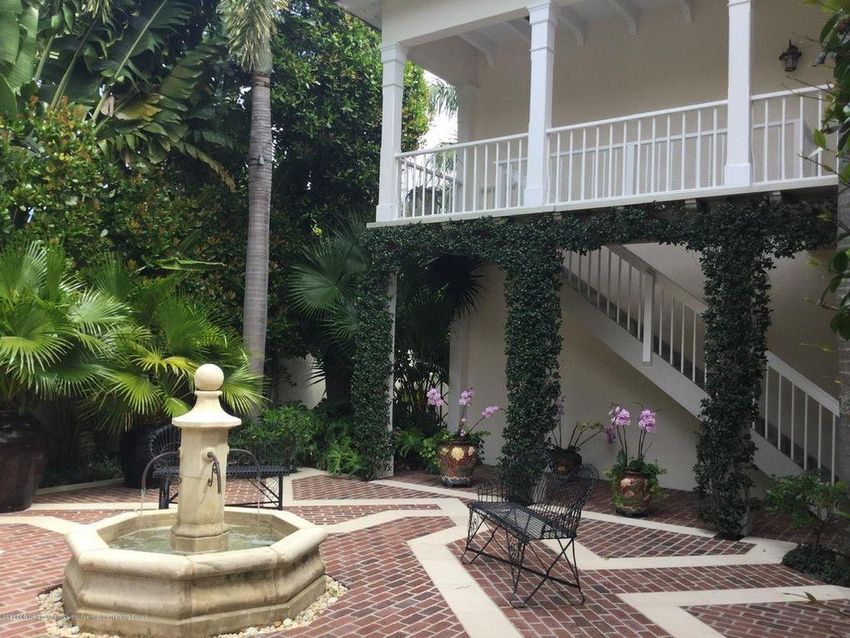
124 Via Bethesda               124 Via Bethesda

                   Images accessed from Google Earth 02.16.2021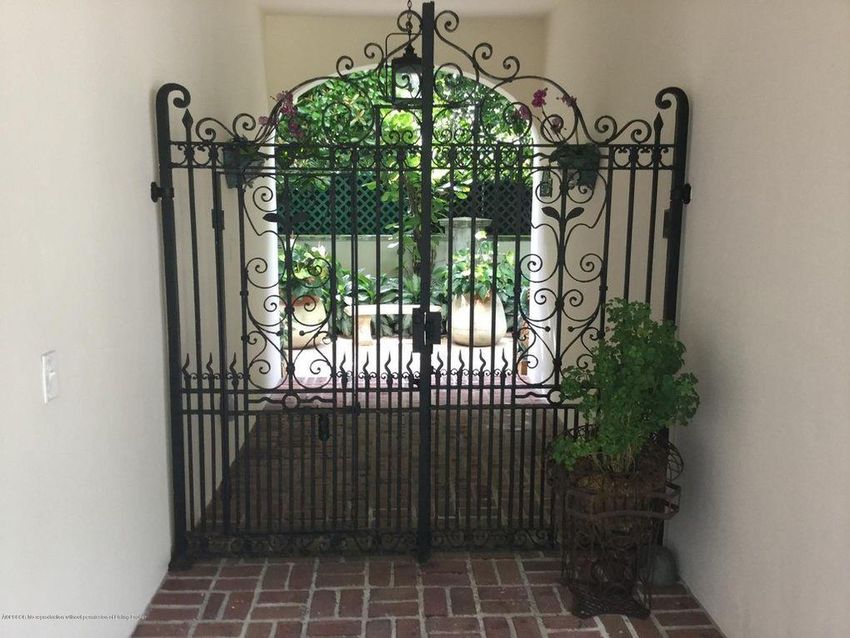
1907 COMMERCE LANE, SUITE 106
                    JUPITER, FLORIDA 33458
                         561 . 575 . 9994
                KIRCHHOFFARCHITECTS.COM

                         guesthouse
                      renovations FOR:

                   fdpb holding
                   company llc
                      102 flagler drive
                     palm beach, FLORIDA

                                   SEAL

             THOMAS M. KIRCHHOFF             FL. REG. NO. AR0014635

                         copyright c 2021
                  kirchhoff & associates architects

                                REVISIONS

                  PROJECT NUMBER:

                  issued for:                       date:
                 arcom                      aPRIL 13, 2021
                  Date plotted:

                  DRAWN BY:                     CHECKED BY:

                       DRAWING NUMBER:

a-036-2021                         SCALE:

                                AS NOTED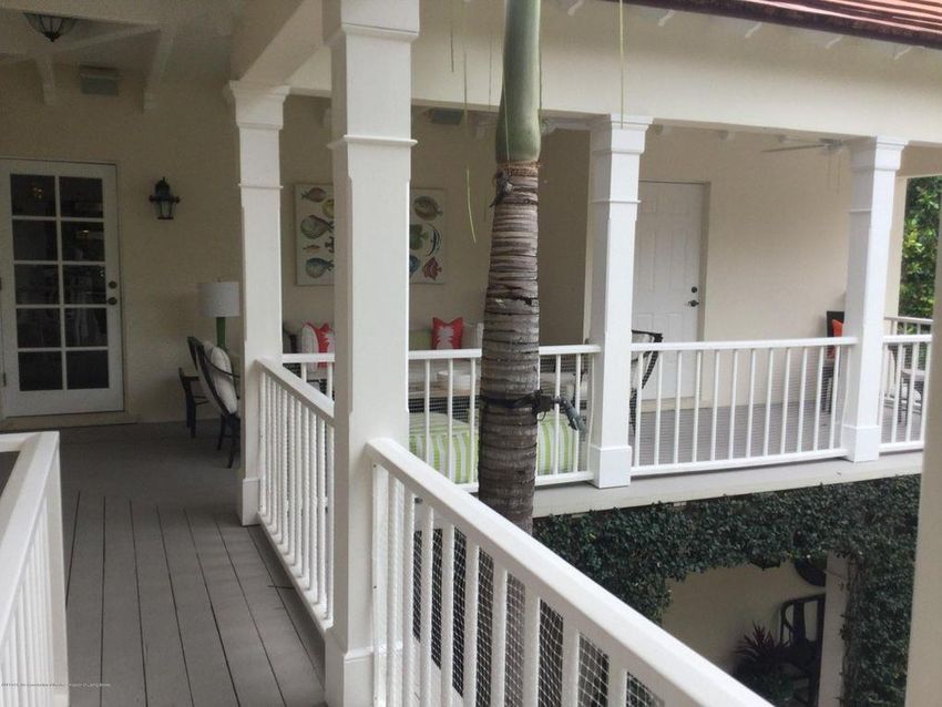
1907 COMMERCE LANE, SUITE 106
                                                                                                                                                 JUPITER, FLORIDA 33458
                                                                                                                                                      561 . 575 . 9994
                                                                                                                                             KIRCHHOFFARCHITECTS.COM

                                                                                                                                                      guesthouse
                                                                                                                                                   renovations FOR:

                                                                                                                                                fdpb holding
                                                                                                                                                company llc
                                                                                                                                                   102 flagler drive
                                                                                                                                                  palm beach, FLORIDA

                                             2ND FLOOR LEVEL
                                             EL. 10'-4"
                                             WALKWAY FLOOR LEVEL
                                             EL. 9'-11.5"

                                             GROUND FLOOR LEVEL
                                             EL. 0'-0"
                                             GARAGE FLOOR LEVEL
                                             EL. -0'-4.5"

 1    EXISTING GUEST HOUSE SOUTH ELEVATION                               2      EXISTING GUEST HOUSE EAST ELEVATION
A-5        1/4" = 1'-0"                                                  A-5            1/4" = 1'-0"

                                                                                                                                                                SEAL

                                                                                                                                          THOMAS M. KIRCHHOFF             FL. REG. NO. AR0014635

                                                                                                                                                      copyright c 2021
                                                                                                                                               kirchhoff & associates architects

                                                                                                                                                             REVISIONS
                                             2ND FLOOR LEVEL
                                             EL. 10'-4"
                                             WALKWAY FLOOR LEVEL
                                             EL. 9'-11.5"

                                             GROUND FLOOR LEVEL
                                                                                                                                               PROJECT NUMBER:
                                             EL. 0'-0"
                                             GARAGE FLOOR LEVEL
                                             EL. -0'-4.5"                                                                                      issued for:                       date:
                                                                                                                                              arcom                      aPRIL 13, 2021
                                                                                                                                               Date plotted:

                                                                                                                                               DRAWN BY:                     CHECKED BY:

                                                                                                                                                    DRAWING NUMBER:

3     PROPOSED GUEST HOUSE SOUTH ELEVATION                         4           PROPOSED GUEST HOUSE EAST ELEVATION- STREET
A-5       1/4" = 1'-0"                                             A-5             1/4" = 1'-0"

                                                                                                                             a-036-2021                         SCALE:

                                                                                                                                                             AS NOTED
LEGEND
A = ARC LENGTH
A/C = AIR CONDITIONING
A.E. = ACCESS EASEMENT
A.K.A. = ALSO KNOWN AS
ASPH. = ASPHALT
BLDG. = BUILDING
B.M. = BENCHMARK
B.O.C. = BACK OF CURB
B.O.W. = BACK OF WALK
(C) = CALCULATED
CATV = CABLE ANTENNA TELEVISION
C.B. = CHORD BEARING
C.B.S. = CONCRETE BLOCK STRUCTURE
C.C.C.L. = COASTAL CONSTRUCTION CONTROL LINE
CH = CHORD
C.L.F. = CHAIN LINK FENCE
CLR. = CLEAR
C.M.P. = CORRUGATED METAL PIPE
CONC. = CONCRETE
(D) = DESCRIPTION DATUM
D.B. = DEED BOOK
D.E. = DRAINAGE EASEMENT
D.H. = DRILL HOLE
D/W
EL.
= DRIVEWAY
= ELEVATION PARCEL 1
ENC. = ENCROACHMENT
E.O.P = EDGE OF PAVEMENT
E.O.W. = EDGE OF WATER
ESM'T = EASEMENT
F.F. = FINISH FLOOR
FND. = FOUND
F.O.C. = FACE OF CURB
GEN. PAD= GENERATOR PAD
INV. = INVERT
I.T.W.C.D. = INDIAN TRAIL WATER CONTROL DISTRICT BOUNDARY SURVEY FOR:
L.A.E.
L.B.
= LIMITED ACCESS EASEMENT
= LICENSE BOARD
FDPB HOLDING COMPANY, LLC, A DELAWARE
L.W.D.D. = LAKE WORTH DRAINAGE DISTRICT
(M) = FIELD MEASUREMENT
LIMITED LIABILITY COMPANY
M.H. = MANHOLE
M.H.W.L. = MEAN HIGH WATER LINE This survey is made specifically and only for the following parties for the purpose of a closing on the surveyed property.
M.L.W.L. = MEAN LOW WATER LINE
N.A.V.D. = NORTH AMERICAN VERTICAL DATUM FDPB Holding Company, LLC, a Delaware limited liability company
N.G.V.D. = NATIONAL GEODETIC VERTICAL DATUM Alley, Maass, Rogers & Lindsay, P.A.
N.P.B.C.I.D.
= NORTHERN PALM BEACH COUNTY Old Republic National Title Insurance Company
IMPROVEMENT DISTRICT
N.T.S. = NOT TO SCALE The undersigned surveyor assumes no responsibility or liability for any other purpose or to any other party other than stated above.
O.A. = OVERALL
O/H = OVERHEAD UTILITY LINE PROPERTY ADDRESS:
O.R.B. = OFFICIAL RECORD BOOK 102 Flagler Drive
O/S = OFFSET Palm Beach, FL 33480
P = PLANTER
LEGAL DESCRIPTION:
(P) = PLAT DATUM
PARCEL 1:
P.B. = PLAT BOOK
P.B.C. = PALM BEACH COUNTY The East half of Lot 14 and the West half of Lot E.
16G.
of PENDLETON TRACT, in the Town of Palm Beach, Palm Beach County,
P.C. = POINT OF CURVATURE Florida, according to the Plat thereof recorded in Plat Book 10, Page 67, Public Records of Palm Beach County,
EXCEPT
Florida.
the
P.C.C. = POINT OF COMPOUND CURVATURE South 12 feet thereof.
P.C.P.
P.E.
= PERMANENT CONTROL POINT
= POOL EQUIPMENT PARCEL 2 PARCEL 2:
PG. = PAGE
P.I. = POINT OF INTERSECTION The North 58.00 feet of Lots 13A and 15 and the South 12.00 feet of the East half of Lot 14 and the South 12.00 feet of the West
P/O = PART OF half of Lot 16 and the North 75.00 feet of that portion of the unnumberedE. G.
LotPENDLETON
in TRACT
adjacent to and
P.O.B. = POINT OF BEGINNING immediately East of the East line of said Lot 15 and South of the South line of Lot 16 if said South line were extended East through
P.O.C. = POINT OF COMMENCEMENT said unnumbered Lot, all in the
E. G. PENDELTON TRACT , in the Town of Palm Beach County, Florida, according to the Plat
P.R.C. = POINT OF REVERSE CURVATURE thereof recorded in Plat Book 10, Page 67, Public Records of Palm Beach County, Florida.
P.R.M. = PERMANENT REFERENCE MONUMENT
PROP. = PROPOSED
P.T. = POINT OF TANGENCY
PVM'T = PAVEMENT
(R) = RADIAL
R = RADIUS
RGE. = RANGE
R.P.B. = ROAD PLAT BOOK
R/W = RIGHT OF WAY
(S) = SURVEY DATUM
S.B. = SETBACK
SEC. = SECTION
S/D = SUBDIVISION
S.F. = SQUARE FEET
S.F.W.M.D.= SOUTH FLORIDA WATER
MANAGEMENT DISTRICT
S.I.R.W.C.D.
= SOUTH INDIAN RIVER WATER
CONTROL DISTRICT
S.R. = STATE ROAD
STA. = STATION
STY. = STORY
S/W = SIDEWALK
T.O.B. = TOP OF BANK
T.O.C. = TOP OF CURB
TWP. = TOWNSHIP
TYP. = TYPICAL
U/C = UNDER CONSTRUCTION
U.E. = UTILITY EASEMENT
U.R. = UNRECORDED
W.C. = WITNESS CORNER
W.M.E. = WATER MANAGEMENT EASEMENT
W.M.M.E. = WATER MANAGEMENT MAINTENANCE EASEMENT
W.M.T. = WATER MANAGEMENT TRACT
BL = BASELINE
CL = CENTERLINE FLOOD ZONE:
This property is located in Flood Zone X, according to F.I.R.M. (Flood Insurance Rate Map) No. 12099C 0583F, dated 10/05/2017.
= CENTRAL ANGLE/DELTA
= CONCRETE MONUMENT FOUND (AS NOTED) NOTES:
= CONCRETE MONUMENT SET (LB #4569) 1. No title policy or commitment affecting title or boundary to the subject property has been provided. It is possible there are deeds and easements, recorded or unrecorded, which could affect this survey and boundaries. This office
= ROD & CAP FOUND (AS NOTED)
= 5/8" ROD & CAP SET (LB #4569)
has made no search of the Public Records.
2. Elevations shown hereon, if any, are in feet and decimal parts thereof and are based on NAVD-88. The expected accuracy of the elevations shown hereon is 0.03' for the hard surface elevations (shown thus x 0.00) and 0.1'
BOUNDARY SURVEY FOR:
= IRON PIPE FOUND (AS NOTED) (shown thus x 0.0) for the soft surface elevations. Elevations shown hereon are U.S. survey feet unless otherwise noted.
= IRON ROD FOUND (AS NOTED) 3. Description furnished by client or client's agent. CERTIFICATION:
4. Unless presented in digital form with electronic seal and electronic signature this survey must bear the signature and the original raised seal of a Florida licensed surveyor or mapper this drawing, sketch, plat or map is for I HEREBY ATTEST that the survey shown hereon conforms to the Standards of
= NAIL FOUND
informational purposes only and is not valid.
FDPB HOLDING COMPANY, LLC, A DELAWARE
Practice set forth by the Florida Board of Professional Surveyors and Mappers
= NAIL & DISK FOUND (AS NOTED)
= MAG NAIL & DISK SET (LB #4569) 5. This survey cannot be transferred or assigned without the specific written permission of Wallace Surveying Corporation. Certificate of Authorization Number LB4569. adopted in Rule 5J-17, Florida Administrative Code pursuant to Section 472.027, LIMITED LIABILITY COMPANY
P = PROPERTY LINE 6. Except as shown, underground and overhead improvements are not located. Underground foundations not located. Florida Statutes, effective September 1, 1981.
L
= UTILITY POLE 7. The survey sketch shown hereon does not necessarily contain all of the information obtained or developed by the undersigned surveyor in his field work, office work or research.
, 8. No responsibility is assumed by this surveyor for the construction of improvements, from building ties shown on this survey. DATE OF LAST FIELD SURVEY: 01/26/2021
= FIRE HYDRANT 9. Revisions shown hereon do not represent a "survey update" unless otherwise noted.
= WATER METER 10. All dates shown within the revisions block hereon are for interoffice filing use only and in no way affect the date of the field survey stated herein.
= WATER VALVE 11. In some instances, graphic representations have been exaggerated to more clearly illustrate the relationships between physical improvements and/or lot lines. In all cases, dimensions shown shall control the location of the
= LIGHT POLE improvements over scaled positions. ______________________________
12. It is a violation of Rule 5J-17 of the Florida Administrative Code to alter this survey without the express prior written consent of the Surveyor. Additions and/or deletions made to the face of this survey will make this survey invalid. Craig L. Wallace
13. The ownership of fences, perimeter walls and/or hedges shown hereon are not known and thus are not listed as encroachments. Fences, hedges and/or perimeter walls are shown in their relative position to the boundary. Professional Surveyor and Mapper
14. The expected horizontal accuracy of the information shown hereon is +/- 0.10'. Florida Certificate No. 3357You can also read


