Vegetation mapping for the protection of old-growth spinifex and pīngao dunes on the uplifted Marlborough coast
←
→
Page content transcription
If your browser does not render page correctly, please read the page content below
Vegetation mapping for the protection of old-
  growth spinifex and pīngao dunes on the
         uplifted Marlborough coast

                      Prepared for
               Marlborough District Council
                       August 2021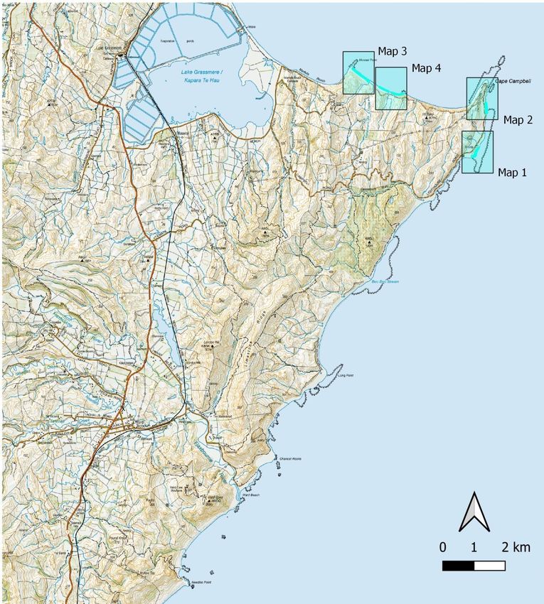
Marine Ecology Research Group
University of Canterbury
Private Bag 4800
Christchurch 8140

Orchard, S. (2021). Vegetation mapping for the protection of old-growth spinifex and pīngao dunes on the
uplifted Marlborough coast. Report prepared for Marlborough District Council. 36pp.

This work is made available under an Attribution-NonCommercial 4.0 International (CC BY-NC 4.0) license.

For further information please contact:
shane.orchard@canterbury.ac.nz
Ph: +64 3 369 4141

Disclaimer
Information contained in report is provided in good faith based on the preliminary results of field studies, literature review
and third party information. Assumptions relied upon in preparing this report includes information provided by third
parties, some of which may not have been verified. The information is provided on the basis that readers will make their
own enquiries to independently evaluate, assess and verify the information’s correctness, completeness and usefulness.

By using this information you acknowledge that this information is provided by the Marine Ecology Research Group
(MERG). Findings, recommendations, and opinions expressed within this document relate only to the specific locations of
our study sites and may not be applicable to other sites and contexts. MERG undertakes no duty, nor accepts any
responsibility, to any party who may rely upon or use this document. This disclaimer shall apply notwithstanding that this
report may be made available to legal entities other than Marlborough District Council.

                                                         Cover image
                        Old-growth spinifex dune near Long Point on the Marlborough coast
                                              Photo: Shane Orchard

                                                          Marine Ecology Research Group, University of Canterbury | www.merg.nz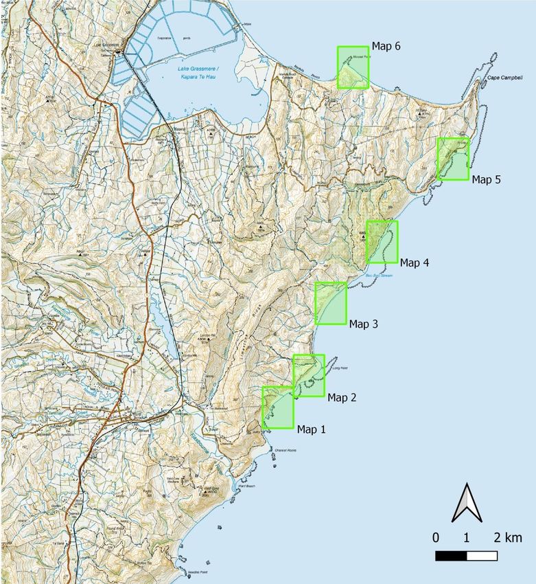
Abbreviations
DOC             Department of Conservation

ECPG            East Coast Protection Group

GIS             Geographic Information System

GPS             Global Positioning System

MBIE            Ministry of Business, Innovation and Employment

MDC             Marlborough District Council

MPI             Ministry for Primary Industries

QEII            Queen Elizabeth II

RECOVER         Reef Ecology and Coastal Values, Earthquake Recovery

UC              University of Canterbury
Contents
1       Introduction ........................................................................................................................5
        1.1     Dune vegetation maps .........................................................................................................5
        1.2     Beach Aid project .................................................................................................................6
        1.3     Scope of report ....................................................................................................................7
2       Methods ..............................................................................................................................8
        2.1     Old growth dune remnants .................................................................................................8
        2.2     Post-earthquake recruits .....................................................................................................8
        2.3     Mapping of protection zones...............................................................................................8
3       Results and discussion .........................................................................................................9
        3.1     Old-growth spinifex .............................................................................................................9
        3.2     Old-growth pīngao .............................................................................................................11
        3.3     New dunes .........................................................................................................................14
                3.3.1         Spinifex recruits ..................................................................................................14
                3.3.2         Pīngao recruits....................................................................................................14
                3.3.3         Focus areas for new dunes .................................................................................15
4       Discussion ......................................................................................................................... 16
5       Acknowledgements ........................................................................................................... 16
6       References......................................................................................................................... 17
Appendix 1 Old-growth spinifex maps .......................................................................................... 18
Appendix 2 Old-growth pīngao maps ........................................................................................... 24
Appendix 3 New dune maps ........................................................................................................ 31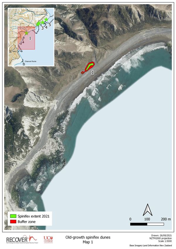
List of Figures
Figure 1. (a) Location of the two initial Beach Aid restoration sites on the Marlborough
      coast. (b) Layout of the trial site at Aerial Beach south of Cape Campbell showing
      three planting zones for the re-establishment of spinifex that differ in their
      configuration between the old dune toe and position of new post-quake high tide
      line. The old dunes at this site are dominated by marram with no native sand-binder
      present. ..........................................................................................................................................7
Figure 2. Two examples of old-growth spinifex dunes in the Booboo Stream area north of
      Long Point. Several large remnants in this area have retained close to 100% cover of
      native dune plants and the area as a whole is an important source of seed for the
      adjacent coastline.Table 1. Dune protection zones for old-growth spinifex remnants. .............10
Figure 3. Dead pīngao (Ficinia spiralis) root mats provide evidence of the native dune
      ecosystem that used to exist at this site near Canterbury Gully on the Marlborough
      coast. ............................................................................................................................................13
Figure 4. Recent loss of pīngao dunes. The arrows in all images point to old root mats of
      dead plants. (a) A pīngao colony recorded by MDC staff south of the Needles that has
      now perished. Only the old root mats were found in the 2021 census survey (. (b)
      View of the now marram-dominated vegetation at the site in (a). (c) another pīngao
      remnant dune located south of the Needles that is holding on but showing signs of
      decline. .........................................................................................................................................13
Figure 5. Only a single new recruit of pīngao (Ficinia spiralis) has been recorded on the
      uplifted beaches between the Waima River and Marfells Beach over 3 years of annual
      surveys (pictured here).. ..............................................................................................................14

List of Tables
Table 1. Dune protection zones for old-growth spinifex remnants. ..................................................... 11
Table 2. Dune protection zones for old-growth pīngao. ....................................................................... 12
Table 3. New dune protection zones. ................................................................................................... 15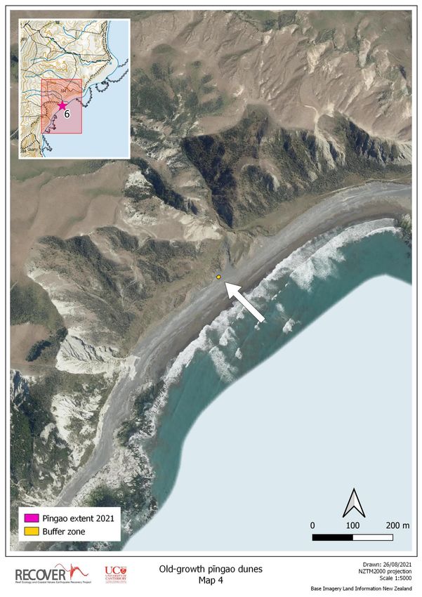
1       Introduction

The University of Canterbury’s RECOVER project (Reef Ecology and Coastal Values, Earthquake
Recovery) is a research programme funded by the Ministry of Business, Innovation and Employment
(MBIE), and supported by the Ministry of Primary Industries (MPI). It has been evaluating recovery
from the 7.8 Mw Kaikōura earthquake in the coastal environment between Oaro in the south and
Marfells Beach in the north. The project has documented a wide range of biological and physical
impacts in the coastal environment over the past four years. These include the widespread mortality
of habitat-forming species that support characteristic ecosystems and natural resources on the coast
(Alestra et al. 2021; Schiel et al. 2019; Tait et al. 2021). Due to the popularity of the coast for
recreational use, interactions between people and the recovering environment are an important
influence on recovery processes. These interactions may include threats to the natural environment
but also the potential for positive interventions that could help to restore natural ecosystems and
resources – including those that have been degraded in the past.

Physical effects of uplift at the coastline include the seaward movement of shorelines and creation of
new land above the reach of the tide, leading to a widening of beaches (Orchard et al. 2020; Orchard
et al. in press). This has also provided a greater opportunity for off-road vehicle access to sections of
the coast previously protected by headlands that were impassable at high tide (Marlborough District
Council 2019; Orchard 2020). MDC management responses have included the development of a
proposed bylaw to reduce the impacts of motor vehicle use in the area (Marlborough District Council
2021). Changes in the position of the sea-level on the landscape also affect the location of
characteristic ecosystems such as sand dunes and storm beaches as they recover to a new norm.
Notable changes include the establishment of new dunes closer to the sea which could potentially
lead to the degradation of old dune systems that may experience reduced sand supply as a result.
Wildlife habitat has also been affected by these uplift and re-assembly effects although the specific
impacts remain largely unknown.

This report contributes to a collaborative project between the Marlborough District Council (MDC)
and University of Canterbury (UC) which aims to help protect and promote the recovery of native
dune systems on the Marlborough coast. It is centred around the mapping of dune vegetation and
identification of dune protection zones for old-growth seed sources of the native sand-binders
spinifex (Spinifex sericeus) and pīngao (Ficinia spiralis). Both are key habitat-formers associated with
nationally threatened dune ecosystems (Holdaway et al. 2012), and pīngao is an important weaving
resource and Ngāi Tahu taonga species. The primary goal is to protect existing seed sources that are
vital for natural regeneration following major disturbances such as the earthquake event. Several
additional protection zones are also identified for areas where new dunes are successfully
regenerating, including areas being actively restored in the Beach Aid project that is assisting new
native dunes to become established where there is available space.

1.1     Dune vegetation maps

The dune vegetation maps show the extent of the native vegetation remnant and a protection zone
for management interventions such as targeted marram (Ammophila arenaria) control. These areas

                                                                                                           5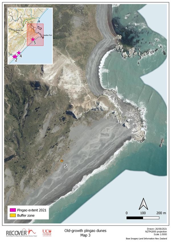
also provide focal points for other protection initiatives such as fencing, other forms of browser
control, signage, or interpretation materials.

Two types of dune protection zones have been identified in this project. For old-growth dune
remnants the protection zone is designed to provide a perimeter defence around the established
area. For new dune recruitment zones including the Beach Aid restoration sites, the dune protection
zone encompasses the area undergoing transition towards new dunes. Marram control and other
interventions in these new dune areas will need to be worked around the establishing plant cover
more closely than is expected to be the case for the protection of old-dunes.

1.2     Beach Aid project
Beach Aid is a restoration and recovery initiative established by UC, MDC, Department of
Conservation (DOC) and East Coast Protection Group (ECPG). It is based on research on the
recruitment of spinifex after the earthquake that showed striking spatial patterns in where new
plants are found. These patterns highlighted linkages with the location of old-growth dune remnants
which emphasise the importance of protecting these existing seed sources. The patchy natural
recruitment pattern also suggested that widespread seed availability may not be the case and that
the ability of native dune plants to colonise newly available areas may be recruitment-limited as a
result. The identification of large gaps in the pattern of recruitment is consistent with this
interpretation.

The Beach Aid project is designed to test this hypothesis directly by re-introducing native plants to
potentially suitable areas and monitoring the results. Initial trials in the summer of 2020 have shown
good survival and growth rates in both spinifex and pīngao at the trial site on Aerial Beach south of
Cape Campbell (Figure 1) and new dune landforms are beginning to develop on the uplifted beach
(Orchard et al. 2020). The most recent plantings have extended the Aerial Beach northwards and
established a second trial site further south. Beach Aid is an opportunistic restoration strategy that
could be readily expanded to many localities across the earthquake-impacted coast. It provides a
novel response to the earthquake by identifying advantageous aspects of the disaster recovery
context that can be engineered to enhance natural resources and reverse previous degradation
trends.

                                                                                                      6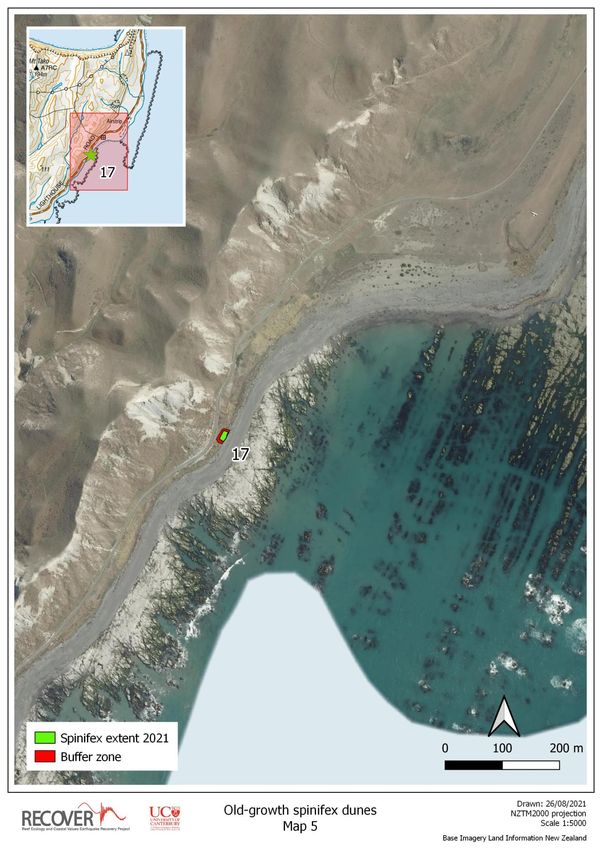
Figure 1. (a) Location of the two initial Beach Aid restoration sites on the Marlborough coast. (b) Layout of the trial
site at Aerial Beach south of Cape Campbell showing three planting zones for the re-establishment of spinifex that
differ in their configuration between the old dune toe and position of new post-quake high tide line. The old dunes at
this site are dominated by marram with no native sand-binder present.
1.3 Scope of report
The reminder of this report provides a brief summary of the mapping results and a series of maps
that identify the dune protection zones.
Each map also shows the location of:
Old-growth native dune remnants throughout the study area and an associated set of dune
protection zones that mainly consist of a buffer on the landward edge.
For the new dune areas, the location of new spinifex recruits as mapped in the summer of
2021 and an indicative footprint of the area requiring protection to assist these dunes
develop.
Additional information on three sandy beach sites that have been the subject of transect-based
monitoring (Mussel Point, Long Point, and Aerial Beach south of Cape Campbell) is available in
Orchard et al. (2020).
7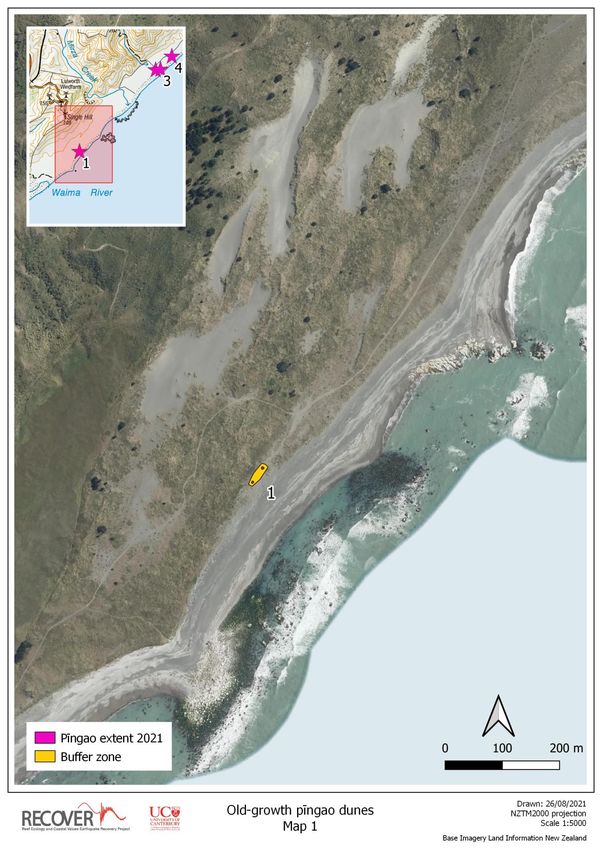
2       Methods
2.1     Old growth dune remnants
A campaign to map the ‘old growth’ dune remnants was begun in the summer of 2018 and continued
over three summers to obtain and refine the data set. In the initial two years, data was collected in
conjunction with the mapping of shorebird nesting grounds using census surveys of the coastline
between the Waima / Ure River and Marfells Beach. These involved a field team of two or three
people walking the coastline in sections and data being collected as points and lines using held-held
GPS devices. In the third summer (2020) further dedicated surveys were undertaken to complete the
dune mapping that incorporated additional data collection on the condition and vegetation
composition of old dune remnants and adjacent areas to be identified as protection zones. These
surveys also ground-truthed maps prepared from the initial surveys, and identified the landward
extent of the larger remnants. The latter had been difficult to complete accurately in some areas due
to the time involved to survey old dunes extending considerable distances inland and challenging
nature of the terrain.

2.2     Post-earthquake recruits
In conjunction with the above surveys, we identified the location of post-earthquake recruits (new
plants) of the two indigenous sand-binding species spinifex and pīngao. New recruits were measured
as point locations for individual plants with a resting height of >20 cm. Plants smaller than this are
generally newly sprouted recruits which can be abundant in places but were observed to often perish
soon after establishment. Point data for individual plants was recorded was taken at the apparent
centrepoint of the colony where there were several runners present. Additional measurements
included the spread (length of long axis and perpendicular width) of each new plant. In the first
summer (2018) this was completed for a limited number of sites only. In 2019 the mapping was
scaled up to the whole coast in combination with the mapping of banded dotterel / pohowera
nesting grounds. These surveys were repeated the following year in conjunction with the old dune
remnant mapping as above.

2.3     Mapping of protection zones
Mapping of point and polygon data was completed in QGIS v3.12 (QGIS Development Team 2021)
based on the GPS data, notes and photographs collected in the field. Two forms of dune protection
zone were identified as described below:

Old-growth protection zones
For old-growth dune remnants, the dune protection zone includes the remnant and an adjacent area
on its landward boundary that is currently dominated by invasive plant species (primarily marram)
and will be targeted for control. These buffer zones were mapped to provide a minimum width of 5
m and up to 10 m, generally following the mapped boundary of the dune remnant but in some cases
aligning with natural features such as the edge of an existing patch of marram or a dune crest or gully
in the landscape.

                                                                                                      8
New dune protection zones
New dune protection zones are identified for a few key sites of interest that have high densities of
new recruits or are the focus of active restoration efforts. They differ from the above because of the
generally sparse vegetation cover. These sites represent newly regenerating dunes and their position
is generally seaward of any old dunes as a consequence of coastal uplift. At some locations, such as
on the beach north of Long Point, the new recruit zone is over 50 m from the old dune toe (see
examples in Orchard et al. 2020). Regular marram control is expected to assist native dunes to gain
an upper hand in the formation of new dunes at these uplifted sites. In additional to those
highlighted in this report, there are many other new dune zones on other beaches along the
earthquake-uplifted coast.
Dune protection zones are mapped as polygons that overlap the values to be protected and included
a buffer zone to be monitored and / or managed for potential threats. The nature of these threats
appears to be different for spinifex and pīngao dunes as is described in the results. Summary
statistics were calculated for the area of the old dune remnants and number of new recruits. The
area of the buffer zone was also calculated separately to provide logistical guidance for marram
control and other protection methods on the ground.
Maps are provided in A4 format at 1:5000 scale, accompanied by centroid coordinates and
shapefiles. In the future this mapping would be ideally repeated to evaluate the success of dune
protection and regeneration effort and inform the marram control programme following an adaptive
approach.
3 Results and discussion
3.1 Old-growth spinifex
A total of 48 old-growth spinifex remnants were mapped as individual polygons in this project. These
occupy a total area of 33.3 ha. Repeat mapping undertaken during the different field campaigns
suggests that the old-growth spinifex dunes were relatively stable over the study period, although it
is difficult to gauge the extent of new marram invasion at some sites, especially where it is
interspersed with the native sandbinders.
Appendix 1 provides vegetation maps for the spinifex remnants. This set of 18 mapped polygons
includes most of the known old-growth dune remnants with the exception of a few smaller patches
and includes all of the larger and most intact spinifex dunes. These include some sites that have
retained close to 100% cover of native dune species despite the presence of marram nearby and are
considered to be priority sites as established strongholds (Figure 2).
The dune protection zones represent a combined area of 9.4 ha of which 6.2 ha represents the buffer
zones for protection of the old-growth remnants. A breakdown of these areas is shown in Table 1.
9Figure 2. Two examples of old-growth spinifex dunes in the Booboo Stream area north of Long Point. Several large
remnants in this area have retained close to 100% cover of native dune plants and the area as a whole is an
important source of seed for the adjacent coastline.
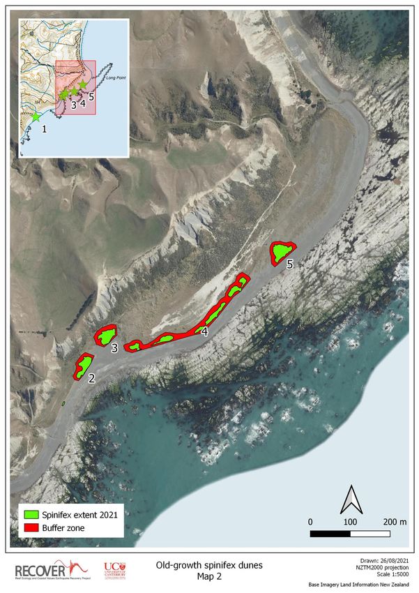
10Table 1. Dune protection zones for old-growth spinifex.
Centroid coordinate Total Area of Area of
(NZTM) area spinifex buffer zone Map
ID
number
X Y (m2) (m2) (m2)
1 1699592 5369426 2027 647 1380 Map 1
2 1700275 5369946 1909 981 928 Map 2
3 1700332 5370022 2194 1063 1131 Map 2
4 1700557 5370063 8013 2391 5622 Map 2
5 1700771 5370232 2643 1299 1345 Map 2
6 1701205 5372522 37228 16131 21097 Map 3
7 1701723 5373048 956 324 632 Map 3
8 1702634 5374057 264 99 165 Map 4
9 1702715 5374112 207 86 121 Map 4
10 1702797 5374271 246 84 162 Map 4
11 1702822 5374304 720 397 323 Map 4
12 1702850 5374376 135 29 106 Map 4
13 1702963 5374643 1636 595 1041 Map 4
14 1703065 5374771 417 147 270 Map 4
15 1703090 5374811 371 128 243 Map 4
16 1703122 5374865 102 31 72 Map 4
17 1705144 5377133 338 161 177 Map 5
18 1702216 5379822 35016 7902 27114 Map 6
3.2 Old-growth pīngao
A total of 13 old-growth pīngao remnants were mapped as individual polygons occupying a total area
of 0.17 ha respectively. Appendix 2 provides vegetation maps for the pīngao remnants. The eight
dune protection polygons represent a combined area of 1.4 ha (Table 2). Five of these are associated
with small and generally isolated pīngao remnants located south of Needles Point. An isolated but
healthy pīngao dune is located at the foot of an old-growth spinifex dune south of Long Point (Map
6). A relatively large dune protection area is mapped for the cluster of pīngao remnants at
Canterbury Gully (Map 7), along with the footprint of a discernible previous dune (Figure 3). The
largest pīngao remnant is located south of Airstrip Beach and appears to be faring better but is
flanked by dense marram stands to the north and south (Map 8).
In contrast to the spinifex remnants, marram invasion does not appear to be a pressing issue at many
of the pīngao remnants which may suggest that other factors are contributing to pīngao decline.
Exceptions include the apparent loss of a pīngao colony south of the Needles that has now been
overtaken by marram. Only a few only pīngao root structures remain to evidence its demise (Figure
4). This example also indicates the speed at which changes are taking place.
Dead root mats were prominent at all of the old-growth pīngao remnants in 2021. They suggest that
much greater vegetation cover existed previously that has since perished and has not been replaced
by new recruitment. These observations highlight a precarious situation for the future of pīngao on
this coast since there has been very little pīngao recruitment to offset the loss of old-growth dunes
11(see below). Action to save the remaining seed sources is recommended in view of the conservation
status of pīngao as an ‘at risk’ species (de Lange et al. 2018) and as a taonga species for Ngāi Tahu
(New Zealand Government 1998; Te Rūnanga o Ngāi Tahu 2014).
Recommendations for consideration include:
detailed monitoring of all remaining pīngao dune remnants include those mapped here and
any others discovered in future field work
further research to establish the drivers of decline which at present are not clear. The
comparison that can be made with spinifex (which appears to be doing much better) may
offer important insights for resolving unknowns through future research.
active steps to protect the remaining pīngao dune remnants informed by the above research
or trialled in association with it. These steps include the establishment of dune protection
zones for marram control as documented here and also the consideration of:
o visual or physical barriers to provide perimeter protection from disturbance threats.
o the control of browsers such as rabbits and hares.
increasing the focus on actively reintroducing pīngao in suitable areas as a component of the
Beach Aid restoration project. A programme of seed collection from the old-growth
remnants detailed here and other nearby sources is recommended to support the
propagation of pīngao seedlings and ensure that restoration plantings are eco-sourced.
Table 2. Dune protection zones for old-growth pīngao.
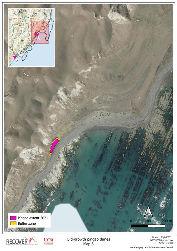
Centroid coordinate Total Area of Area of
(NZTM) area pīngao buffer zone Map
ID
2 2 2 number
X Y (m ) (m ) (m )
1 1693599 5361031 574 27 547 Map 1
2 1694930 5362458 20 2 18 Map 2
3 1695014 5362467 106 32 74 Map 2
4 1695212 5362695 64 12 52 Map 2
5 1696075 5363519 186 34 152 Map 3
6 1699608 5369425 69 24 45 Map 4
7 1703915 5375930 10752 100 10652 Map 5
8 1705180 5377241 2261 1492 768 Map 6
12Figure 3. Dead pīngao (Ficinia spiralis) root mats provide evidence of the native dune ecosystem that used to exist at
this site near Canterbury Gully on the Marlborough coast.
A B
C
Figure 4. Recent loss of pīngao dunes. The arrows in all images point to old root mats of dead plants. (a) A pīngao
colony recorded by MDC staff south of the Needles that has now perished. Only the old root mats were found in the
2021 census survey (. (b) View of the now marram-dominated vegetation at the site in (a). (c) another pīngao
remnant dune located south of the Needles that is holding on but showing signs of decline.
133.3 New dunes
3.3.1 Spinifex recruits
Over twice as many new spinifex recruits (n = 577) were mapped in the most recent census survey
(2021) compared to the year before. However, there were also many areas in which previously
recorded recruits were no longer present the following year, indicating that mortality had occurred.
This indicates that the observed recruitment pattern is resulting from a dynamic series of gains and
losses. Although a detailed analysis of these effects is beyond the scope of this report, some
examples of interesting recruitment patterns in relation to the position of old-growth dune remnants
were shown in an earlier report (Orchard et al. 2020).
3.3.2 Pīngao recruits
There have been very few pīngao recruits identified in the entire area over the three years of survey
effort. Only a single pīngao recruit has been recorded in the new space created on uplifted beaches
in marked contrast to the establishment of spinifex, marram and other coastal vegetation (Figure 5).
The only other new recruits recorded were at the Canterbury Gully site where they fall within the
area covered by the old dune protection zone and may be relatively old plants that have remained
small in stature. They were recorded in the initial surveys in 2018 and no new plants have been
recorded there since.
Figure 5. Only a single new recruit of pīngao (Ficinia spiralis) has been recorded on the uplifted beaches between the
Waima River and Marfells Beach over 3 years of annual surveys (pictured here).
143.3.3 Focus areas for new dunes
Focus areas for the creation of new dunes include the beaches north and south of Long Point, south
of Cape Campbell, and to the east of Mussel Point. Vegetation maps are provided for five of these
locations in Appendix 3. Three of these are located in different sections of the Mussel Point beach
that have been selected as focus areas for management through discussions with MDC staff (Mike
Aviss, pers. comm.). These areas feature a high density of new spinifex recruits and include the
location of the only recorded pīngao recruit in the new dune zone. The high recruitment levels
observed here most likely reflect the influence of the significant old-growth dunes further west on
Marfells Beach additional to the QEII covenanted remnant on the hillslope behind Mussel Point
which provide seed sources. The remaining two new dune vegetation maps cover the Beach Aid
restoration sites south of Cape Campbell. At both sites there is now a combination of natural
recruited and planted spinifex. Pīngao plantings are also being trialled at the Aerial Beach site at are
doing well at the time of writing.
The five polygons represent a combined area of 6.7 ha (Table 3). The area of native dune cover was
calculated from the spread measurements of individual recruits and therefore does not include the
contribution of additional areas that have been planted. As described in section 1, the protection
zones in these new dune areas are primarily open sand in contrast to old-dune situations. Invasive
species such as marram are present as isolated clumps that can be periodically targeted for removal
to assist the regeneration of native dune vegetation at these sites.
Table 3. New dune protection zones.
Area of Area of
native dune protection Map
ID Location cover zone number
2 2
(m ) (m )
1 Beach Aid site – Airstrip Beach 37 17593 Map 1
2 Beach Aid site – Aerial Beach 735 15756 Map 2
3 Mussel Point west 337 19369 Map 3
4 Mussel Point centre 166 6252 Map 4
5 Mussel Point east 571 8267 Map 4
154 Discussion
Implementation of the dune protection zones identified here will assist MDC and other stakeholders
to achieve objectives for beach and dune conservation on the Marlborough coast. They have a
primary focus on protecting existing seed sources and supporting the Beach Aid project to
regenerate new dunes on uplifted beaches to obtain net gains from opportunities presented by the
Kaikōura earthquake event.
Additional new dune protection zones could readily be added in the future as the overall project
progresses. However, as new site requires additional resources it may not be possible to tackle some
of the larger and more remote areas such as the beach north of Long Point mentioned above. In
general, it is recommended that the old dune protection zones are maintained as a priority since
these represent the major existing seed sources.
Priorities for the selection of further new dune protection zones are considered to be:
all sites that are the focus of active dune regeneration efforts in the Beach Aid project.
readily accessible sites with high densities of naturally-occurring recruits.
For both of the above situations it is recognised that the marram control operation will become
progressively more difficult (and/or require a greater degree of precision) as the number and density
of native dune plants increases. It is anticipated that the overall marram control programme will tend
towards the spot removal of marram over time to help encourage pure stands of native sand-binders
to develop and form primarily native ‘new dunes’. Regular monitoring will be beneficial to identify
the level of marram recruitment and / or regrowth to inform the frequency of control work.
5 Acknowledgements
We thank Marlborough District Council staff for collaboration on this project, with particularly thanks
to Mike Aviss. We also thank local landowners and community members who have assisted with
establishment of study sites and coastal surveys in support of this work. A large number of additional
people have contributed to the Beach Aid project including MDC and DOC staff, ECPG members, local
businesses and planting day volunteers. Funding for the RECOVER project was provided by the New
Zealand Ministry of Business, Innovation and Employment (MBIE), and the Ministry for Primary
Industries (MPI).
166 References
Alestra, T., Gerrity, S., Dunmore, R. A., Crossett, D., Orchard, S., & Schiel, D. R. (2021). Rocky reef
impacts of the 2016 Kaikōura earthquake: extended monitoring of nearshore habitats and
communities to 3.5 years. New Zealand Aquatic Environment and Biodiversity Report No. 253.
Report prepared for the Ministry for Primary Industries. 46pp.
de Lange, P., Rolfe, J. R., Courtney, S. P., Barkla, J. W., Champion, P. D., Perrie, L. R., . . . Ladley, K.
(2018). Conservation status of New Zealand indigenous vascular plants, 2017. New Zealand
Threat Classification Series 22. Wellington: Department of Conservation. 82 pp.
Holdaway, R. J., Wiser, S. K., & Williams, P. A. (2012). Status assessment of New Zealand's naturally
uncommon ecosystems. Conservation Biology, 26(4), 619-629. doi:10.1111/j.1523-
1739.2012.01868.x
Marlborough District Council. (2019). Marlborough's East Coast - Issues and Options. Report
prepared by Marlborough District Council, November 2019. 48 pp.
Marlborough District Council. (2021). Proposed East Coast Beach Vehicle Bylaw Technical Report. July
2021. Marlborough District Council. 118pp.
New Zealand Government. (1998). Ngāi Tahu Claims Settlement Act 1998. Reprint as at 1 August
2020. Wellington: New Zealand Government.
Orchard, S. (2020). Recreational activities on earthquake-affected beaches in Marlborough. Summary
results from an online survey of public perceptions. University of Canterbury Marine Ecology
Research Group. 5pp. Available from https://hdl.handle.net/10092/101417.
Orchard, S., Falconer, T., Fischman, H., & Schiel, D. R. (2020). Beach dynamics and recreational access
changes on an earthquake-uplifted coast. Report prepared for Marlborough District Council.
ISBN 978-0-473-54390-7 (Print), ISBN 978-0-473-54392-1 (Online). 42pp. Available online
from https://hdl.handle.net/10092/101043.
Orchard, S., Fischman, H. S., Gerrity, S., Alestra, T., Dunmore, R., & Schiel, D. R. (in press). Threshold
effects of relative sea-level change in intertidal ecosystems: empirical evidence from
earthquake-induced uplift on a rocky coast. Geohazards.
QGIS Development Team. (2021). QGIS Geographic Information System. Open Source Geospatial
Foundation Project. http://qgis.org.
Schiel, D. R., Alestra, T., Gerrity, S., Orchard, S., Dunmore, R., Pirker, J., . . . Thomsen, M. (2019). The
Kaikōura earthquake in southern New Zealand: Loss of connectivity of marine communities
and the necessity of a cross‐ecosystem perspective. Aquatic Conservation: Marine and
Freshwater Ecosystems, 29(9), 1520-1534. doi:10.1002/aqc.3122
Tait, L. W., Orchard, S., & Schiel, D. R. (2021). Missing the forest and the trees: Utility, limits and
caveats for drone imaging of coastal marine ecosystems. Remote Sensing, 13(16), 3136.
doi:10.3390/rs13163136
Te Rūnanga o Ngāi Tahu. (2014). Pīngao – A taonga. Ōtautahi Christchurch: Te Rūnanga o Ngāi Tahu.
Retrieved 25 August 2020 from https://ngaitahu.iwi.nz/our_stories/pingao-taonga/.
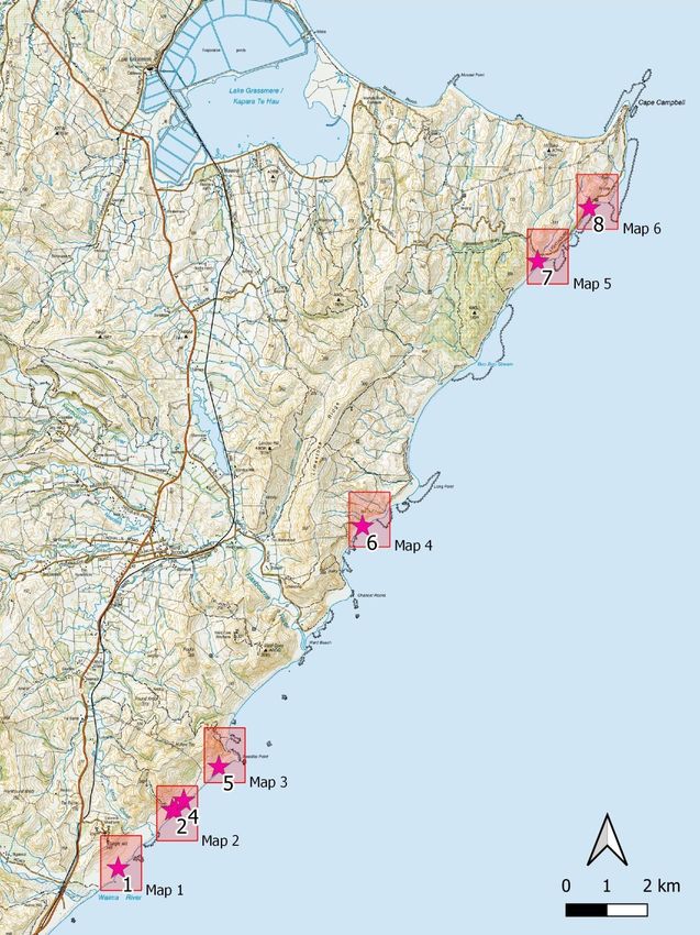
17Appendix 1 Old-growth spinifex maps
Fig. A1. Key to old-growth spinifex maps.
1819
20
21
22
23
24
Appendix 2 Old-growth pīngao maps

Fig. A2. Key to old-growth pīngao maps.

                                          25
26
27
28
29
30
31
Appendix 3 New dune maps

Fig. A3. Key to new dune maps.

                                 32
33
34
35
36
37
You can also read