New Station Initial Business Case - HIGHWAY 27-WOODBINE - Metrolinx
←
→
Page content transcription
If your browser does not render page correctly, please read the page content below
New Station
Initial Business Case

   HIGHWAY 27-WOODBINE

November 2018
NEW STATION BUSINESS CASE
                                                                                                                 HIGHWAY 27-WOODBINE

Table of Contents
1.     Introduction .................................................................................................................................. 1
       1.1       Background ................................................................................................................................................1
       1.2       Problem Statement ....................................................................................................................................1
       1.3       Report Scope and Purpose .......................................................................................................................1

Scenario A       No Replacement for Etobicoke North Station ................................................................ 4
       2.1       Station Removal Context and Concept ...................................................................................................4
       2.2       Strategic Case ............................................................................................................................................4
       2.3       Financial and Economic Case...................................................................................................................5
       2.4       Deliverability and Operations Case ...................................................................................................... 10

Scenario B       New Station at Highway 27-Woodbine .......................................................................... 11
       3.1       Station Context and Concept Plan ........................................................................................................ 11
       3.2       Strategic Case ......................................................................................................................................... 15
       3.3       Financial and Economic Case................................................................................................................ 27
       3.4       Deliverability and Operations Case ...................................................................................................... 32

Appendix A:                  Financial and Economic Analysis Assumptions .............................................. 35
Appendix B:                  Ridership Inputs and Results Summary............................................................ 36
Appendix C:                  Future Service Considerations .......................................................................... 37

November 2018                                                                                                                                                               i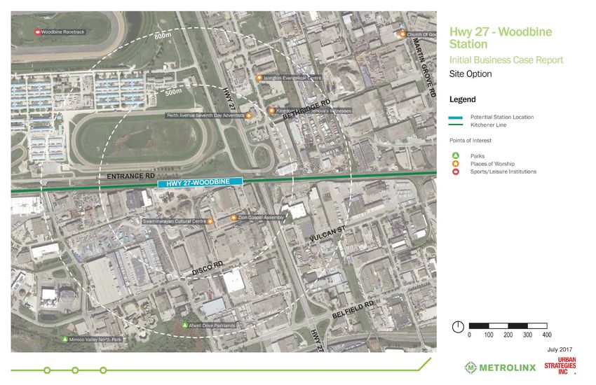
NEW STATION BUSINESS CASE
                                                                                HIGHWAY 27-WOODBINE

1.        Introduction

1.1       Background
Recent provincial planning and policy initiatives call for significant operational changes in GO rail services in the
Greater Toronto and Hamilton Area (GTHA). The GO Expansion program will bring more train trips to every GO
rail corridor, including increased weekday rush-hour and non-rush hour periods, evenings and weekends. Electric
trains will run every 15 minutes or better, all day and in both directions, within the most heavily travelled sections
of the network.

To address considerations emerging from the GO Expansion program, the City of Toronto’s SmartTrack plan and
other transit initiatives, Metrolinx initiated an examination of potential new station locations across the seven
existing GO rail corridors. New stations should improve access to the GO rail network and meet strategic,
financial (affordability), economic, and operational and deliverability objectives without significantly
compromising the regional service objectives of GO and its base of users.

An initial identification of over 120 potential station sites was narrowed to 56 through a high-level evaluation of
transport connectivity, planning and land use and technical feasibility. The 56 potential locations were then
evaluated against 38 criteria and nine key criteria, yielding 24 sites on corridors that would be suitable for major
infrastructure investment as part of the GO Expansion program, to be evaluated in more detail using an Initial
Business Case (IBC).

1.2       Problem Statement
To maximize the benefits of the GO Expansion program, new stations are proposed on the rail network to
improve access to/ egress from the GO rail network and generate new ridership. Stations should meet strategic,
affordability, economic, and deliverability objectives without significantly compromising the regional service
objectives of GO and its base of users on opening day.

In addition, the Highway 401 Rail Tunnel expansion project to support the GO Expansion program will require
the closure of the existing Etobicoke North GO station, as new tracks will compromise the platforms at Etobicoke
North station. The timing of the station closure is not yet confirmed and will be determined as part of the broader
corridor expansion works.

1.3       Report Scope and Purpose
The scope of this IBC report is to examine the effectiveness of: 1) closing Etobicoke North Station without
replacement (Scenario A) or 2) a proposed new station near Highway 27 and the Kitchener corridor at Woodbine
Race Track (Scenario B). In June 2016, the Metrolinx Board directed staff to complete the IBC analysis for a
Highway 27-Woodbine station. This report provides an initial overview of the impact on local objectives (the
Strategic Case), the financial and economic performance of the scenarios (the Financial and Economic Cases),
and deliverability and operational considerations (the Deliverability and Operations Case) of both scenarios.

Metrolinx also investigated 50 Resources Road (east of Islington Avenue and south of Highway 401) as a potential
replacement for Etobicoke North station. However, early in the assessment of this potential location, several
issues were identified:

     •   There is a restrictive covenant on title which currently prevents the use of the land as a passenger rail
         station;

November 2018                                                                                                       1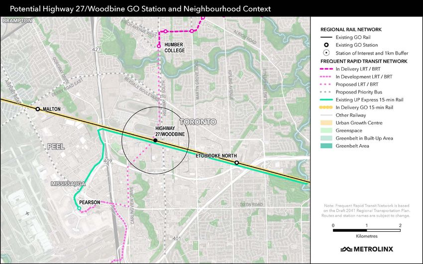
NEW STATION BUSINESS CASE
                                                                            HIGHWAY 27-WOODBINE

   •    The surrounding area has limited potential for transit-oriented development. Aside from some parcels
        that contain low intensity employment and commercial uses, the surrounding area is characterized by
        stable, low-rise residential areas and the Weston Golf and Country Club. The Humber River, which runs
        east of the site, would present an additional constraint to development;
   •    The site offers no connections to higher order transit; and
   •    Highway 401 presents a barrier to connectivity for potential users arriving to the station by foot or by
        bicycle.

The quantitative analysis conducted as part of this IBC has assumed that the station is only served by Kitchener
corridor GO trains. The project team identified several parallel transit service and infrastructure options that
could potentially impact the preferred station concept and performance in the business case evaluation,
including:

   1.   Operation of Highway 27-Woodbine as an additional UP Express stop;
   2.   Extension of the Finch West LRT from Humber College to Pearson International Airport;
   3.   Construction of additional tracks on the Kitchener corridor for a freight bypass;
   4.   Construction of a new passenger rail bypass through an alternate airport hub;
   5.   Implementation of high speed rail on the Kitchener corridor; and
   6.   Operation of Highway 27-Woodbine as a terminus station for evening/weekend event trains.

The potential impacts of these options were considered at a high-level and are documented in Appendix C.

November 2018                                                                                                 2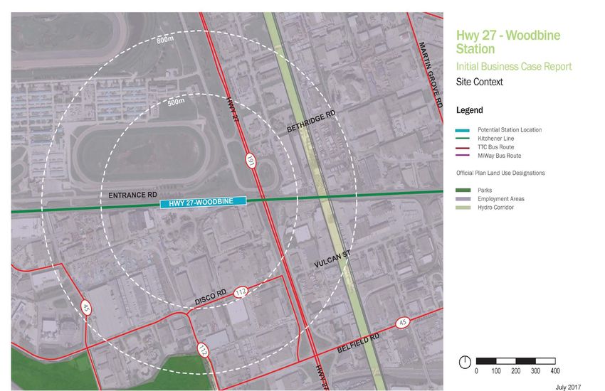
NEW STATION BUSINESS CASE
                                                                          HIGHWAY 27-WOODBINE

Figure 1-1: Highway 27-Woodbine station in the wider rapid transit network context

November 2018                                                                                  3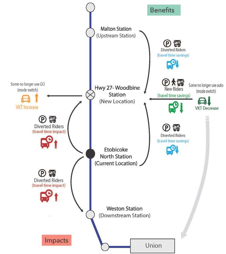
NEW STATION BUSINESS CASE
                                                                                HIGHWAY 27-WOODBINE

Scenario A              No Replacement for Etobicoke North Station

2.1       Station Removal Context and Concept
Etobicoke North station is approximately 6 km from Malton GO station to the west and 4 km from Weston GO
station to the east. It is also adjacent to a rail tunnel that carries the Kitchener Corridor under Highway 401/409.
To help increase capacity on this corridor, infrastructure upgrades are required: Construction of a second tunnel
under Highway 401/409 to accommodate two additional tracks, future signaling and communications
infrastructure; and replacing footings of retaining walls that support the ramp from eastbound Highway 409 to
eastbound Highway 401. These improvements will require the closure of Etobicoke North GO station as the new
track alignment will displace the station platform, and site conditions cannot accommodate an alternate
configuration. No feasible alternative configuration for Etobicoke North GO has been identified. The corridor is
constrained by grades to the north, a bridge over Kipling Avenue and MTO property to the south. The timing of
the station closure is not yet confirmed and will be determined as part of the broader corridor expansion works.

2.2       Strategic Case
According to the GO Rail Station Access Plan, in 2016 625 daily riders used the current Etobicoke North station
as a home station. The majority of customers arrive from between 5 and 10 km away, with approximately 71%
driving and parking, and 12% being dropped off. With adequate improvements to station access facilities,
adjacent stations could support these users, with some inconvenience. Seven percent of customers currently
access the station by local transit, particularly the route 45 Kipling buses. A transit journey to an alternate station
would be significantly less convenient for these users.

Table 2-1: Strategic Case Summary Results

 Strategic Case Summary                                       Etobicoke North (decommissioned)
                                           Decommissioning stations is generally not supported by regional or
 Policy Alignment                          local policy. The station continues to be listed in municipal planning
                                           documents.
                                           Presence of the GO station has not supported density in the area or
 Development Potential and
                                           station-related development. The area is designated Employment and
 Intensification
                                           there is currently limited development activity in the area.
 Real Estate Market Demand                 Limited current and future market demand.
 Natural Environment                       No significant environmental considerations within 800 m.
                                           Approximately 6 km from Malton GO station to the west and 4 km
 Operational System
                                           from Weston GO station to the east.
                                           The immediate station area has few ridership drivers. Connectivity to
 Connectivity and Ridership Drivers        the GO network would be reduced, and access would be curtailed for
                                           users connecting via the TTC Route 45 Kipling buses.
                                           Removal of the station would reduce access to the network. Adjacent
                                           stations both have high utilization of parking and access infrastructure
 Station Access
                                           and limited capacity for expansion to serve displaced Etobicoke
                                           North users.
                                           Removal of the station would reduce access to surrounding
 Social Inclusivity and Accessibility      employment areas and transit passengers connecting from residential
                                           areas to the north and south.

November 2018                                                                                                         4
NEW STATION BUSINESS CASE
                                                                                          HIGHWAY 27-WOODBINE

Traffic zone level forecasts indicate that approximately 1,400 residents and 2,700 jobs will be located within 800
m of the station site in 2031.This equates to a projected population-and-job density of 20 people and jobs per
hectare (P+J/ha), which is not considered transit-supportive according to Metrolinx’s density guidelines for
                                        1
express rail stations (150–300 P+J/ha) . Current development activity within 800 m of the station site is limited.

The majority of land surrounding Etobicoke North GO is designated as Employment Area. The conversion of
Employment Areas to other uses is permitted only through Municipal Comprehensive Review. Applications to
convert Employment Areas are reviewed both individually and in aggregate, taking into account population
forecasts, employment forecasts, and compatibility with other uses in the area, among other considerations.
Municipal Comprehensive Reviews are required by the Province every five years, thus the City of Toronto’s next
review must be in force by July 1, 2022.

Decommissioning of Etobicoke North GO is unlikely to facilitate new development as lands for the station and
platforms would be absorbed by new tracks and infrastructure and parking areas are contained within a hydro
corridor, where permitted uses are typically limited to parking, and storage.

2.2.1             Stakeholders
There are a range of stakeholders that might or will be affected by the decommissioning of a station at Etobicoke
North. These include:

    •    Metrolinx Operations and Capital Projects Group
    •    Municipalities: City of Toronto
    •    Elected officials: Toronto City Councillor (Ward 2 Etobicoke North); Member of Provincial Parliament;
         Member of Parliament
    •    Transit agencies: Toronto Transit Commission
    •    Owners, developers, and residents of adjacent properties
    •    Travelers (transit, road, and active transportation users)

2.3        Financial and Economic Case

2.3.1 Analysis Approach
The Financial and Economic Case for a new station, relocation, or closure depends on forecasts of how travellers
will respond to the change in the transportation network. Individuals who use a new or relocated station can
benefit by saving time relative to their previous travel option – travelling farther to another GO station, or using a
different transport mode such as subway, bus, or automobile. A station closure or relocation can also impact
some GO riders with longer travel times, if riders now need to use another station that is less convenient for their
journey. Changes to stations also impact upstream riders, who may experience longer travel times when a stop is
added along the way to their destination. Changes to automobile usage, roadway congestion, and environmental
outcomes can also occur as individuals reconsider their mode choice decisions when the change in station
options occurs (e.g. commuters that live or work in close proximity to a new station may now choose to use GO
instead of their car).

The IBC for Highway 27-Woodbine uses a modelling and analysis approach that is consistent with the 12 new
                                                                                2
station Preliminary Design Business Cases (PDBCs) that were issued in March 2018 . The Highway 27–Woodbine

1
  Transit-supportive density of an “Express Rail” mobility hub, Metrolinx Mobility Hub Guidelines for the Greater Toronto and Hamilton
    Area, Metrolinx, September 2011
2
  See Technical Report: GO Expansion RER New Stations Business Case Analysis (Attachment A) for details.

November 2018                                                                                                                       5
NEW STATION BUSINESS CASE
HIGHWAY 27-WOODBINE
business case analysis measures and captures the same types of travel time and automobile usage benefits and
impacts and applies the same modelling and analysis methods. The analysis also shares the same travel demand
modelling approach that utilizes the Greater Golden Horseshoe travel demand model to forecast ridership and
transportation user benefits. Consistent with the PDBCs, the business case for Highway 27-Woodbine assumes
that the new station is built for level boarding from the outset and that fare integration is in place between GO
and TTC (i.e. no difference in cost to take TTC, GO, or both). The analysis also makes use of municipally-derived
forecasts of population and employment for 2031, most notably utilizing the same citywide traffic zone level
forecasts provided by the City of Toronto.
The following sections summarize the key benefits and impacts that are quantified in the analysis, the results of
the Financial and Economic Case, and discuss the key travel markets that are impacted by the Etobicoke North
3
station closure scenario. Please refer to the GO Expansion New Stations Modelling Backgrounder (April 2018) for
a more detailed discussion of the overall modelling approach, inputs, assumptions, and tools that were used to
support the analysis.
2.3.2 Scenario Benefits and Impacts
Highway 27–Woodbine station is different from the other stations that were analyzed in the 12 PDBCs issued in
March 2018 since one of the options is a closure of the existing Etobicoke North station. The station closure saves
time for upstream riders since they are no longer stopping at Etobicoke North; Kitchener corridor trains that
would have previously stopped at Etobicoke North would now travel through without stopping. However, the
station closure impacts GO riders that would have previously used Etobicoke North station and now must use an
alternate station such as Malton or Weston. As part of the closure scenario, 700 additional parking spaces have
been assumed to be added to Malton station to replace the lost parking at Etobicoke North station. As visually
summarized by Figure 2-1, examining travel time savings, delays, and modal shifts is the focal point of the
technical analysis that supports the Financial and Economic case for the closure of a station.
3
http://www.metrolinx.com/en/regionalplanning/newstations/2018-04-13%20Stations%20Technical%20BackgrounderFINAL.pdf
November 2018 6NEW STATION BUSINESS CASE
HIGHWAY 27-WOODBINE
Figure 2-1: Station Closure Benefit and Impact Analysis
2.3.3 Results Summary and Sensitivity Analysis
The economic analysis monetizes the forecast transportation user benefits and impacts and environmental
outcomes associated with the Etobicoke North station closure over a 60-year analysis lifecycle. Please refer to
Appendix A for an overview of the key financial and economic analysis model input assumptions used in the
analysis. These assumptions have been updated for consistency with analysis parameters in the upcoming
4
Version 1.0 release of the Metrolinx Business Case Guidance . This includes generating a range of benefits
4
The Draft Business Case Guidance (March 2018) is accessible here:
http://www.metrolinx.com/en/regionalplanning/projectevaluation/benefitscases/benefits_case_analyses.aspx
November 2018 7NEW STATION BUSINESS CASE
HIGHWAY 27-WOODBINE
through sensitivity testing using different Value of Time Growth rate assumptions (0%/year and 0.75%/year
respectively).
Table 2-2, below, summarizes the key metrics that quantify the overall economic performance of Scenario A: No
Station Replacement. Appendix B provides a summary of the key inputs to the IBC analysis, including modelled
GO service levels and station area land use.
The high level cost estimate combines capital costs (excluding property) and operating costs over the 60 year
analysis lifecycle. See 2.3.3.3 for more details.
Table 2-2: Economic Analysis Summary Results (Millions of 2017 $, Present Value)
Scenario A:
No Station Replacement
2031 Etobicoke North Ridership (Daily)
7,100
boardings + alightings
2031 Change in GO Ridership (Daily)
-2,600
boardings + alightings
Benefits Compared to Cost Benefits are Positive and Exceed Costs
[1]
Benefit Cost Ratio (BCR) n/a
Total Benefits $70 M to $90 M
(60yr lifecycle) 0% Value of Time Growth 0.75% Value of Time Growth
Travel Time Savings $74 M $92 M
Existing GO Riders $60 M $78 M
New GO Riders $14 M $14 M
Vehicle Operating Cost Savings -$1 M -$1 M
Decongestion on Road Network -$2 M -$2 M
Safety Impacts -$0.3 M -$0.3 M
Environmental Impacts -$0.1 M -$0.1 M
Total Costs -$15 M to -$10 M
Capital Costs $12 M to $15 M
Operating Costs -$25 M
[1]
The savings in operating costs from the station closure results in an overall savings in cost. A BCR is produced
to compare benefits to the incremental cost of a given project or program.
Without fare integration between GO and TTC, the reduction in daily GO trips (boardings and alightings) is
forecast to be about 900 in 2031 and total benefits are forecast to be in the range of $70 M - $100 M (2017$,
Present Value) over the 60 year lifecycle. Under the station replacement scenario, fare integration attracts 2.5
times more impacted riders to Etobicoke North station. Upstream ridership, on the other hand, is similar with and
without fare integration since Etobicoke North station is the westernmost station in Toronto on the Kitchener
corridor.
2.3.3.1 Travel Time Savings and Ridership
GO riders that travel through on Kitchener corridor trains that stop at Etobicoke North station would have a faster
trip if it were closed. Riders would save approximately 2 minutes when accounting for the time to slow down, stop
November 2018 8NEW STATION BUSINESS CASE
HIGHWAY 27-WOODBINE
5
at the station, and get back up to speed . Riders that would have boarded or alighted at Etobicoke North station,
on the other hand, would experience longer travel times since they would need to divert to another station.
Malton and Weston, which are the next closest stations on the Kitchener corridor, are located about 8km to the
west and 6km to the east via the road network respectively.
As discussed in Section 2.3.2, the station closure scenario assumes that 700 spaces would be added at Malton
station to accommodate Park-and-Ride users that previously used Etobicoke North. According to the 2017 GO
Passenger Survey, approximately 80% of existing Etobicoke North users arrived in a car that parked at the station.
Malton station is expected to provide comparable auto access times for many Etobicoke North Park-and-Ride
users; data from the 2015 GO Passenger Survey data indicates that Malton station is already the closer access
station for over 50% of riders that currently use Etobicoke North. Transit and walk access or egress users,
however, are more significantly impacted by the station closure. Overall, it is estimated that former Etobicoke
North station users would be delayed by about 5 minutes on average due to the station closure by having to go
to an adjacent station.
On balance, the travel time benefits to upstream riders are forecast to be greater than the travel time delays for
Etobicoke North station users. This is primarily because upstream riders on GO’s Kitchener corridor local trains
outnumber Etobicoke North station users by between 3-4 times.
2.3.3.2 New GO Riders and Automobile Usage Reductions
The station closure is forecast to lead to a net reduction of approximately 2,600 daily trips on the GO network in
2031, which is about 40% of the forecasted ridership at Etobicoke North station. Although Malton station is a
feasible alternative access station for many Etobicoke North riders, it is an inconvenient backtrack for riders that
are located to the east of the existing station between Highway 27 and Weston. The closure also significantly
impacts riders that would have walked to the station from surrounding areas or used TTC bus Route 45 along
Kipling Avenue to access the station. Route 45 provides a connection to feasible alternatives to Etobicoke North
station since it continues 9km to the south of the station where it terminates at Kipling station on the TTC
subway’s Line 2 and GO’s Milton corridor. The net reduction to GO ridership resulting from the closure, including
the modal shifts of former Etobicoke North riders and new upstream riders, is forecast to translate about a $50M
(2017$, Present Value) decrease in GO fare revenue over the 60 year analysis lifecycle.
The closure of the station is anticipated to cause a small net decrease in personal automobile use, when
considering riders that no longer use GO, new upstream GO riders, and Park-and-Ride access changes. Overall,
the economic impact of the change in automobile usage is minimal in comparison to the travel time savings and
impacts of the closure.
2.3.3.3 Project Costs
The closure of Etobicoke North station is forecast to result in a net savings of approximately $10M - $15M ($2017,
present value) in capital and operations costs over the 60 year analysis lifecycle. The operations cost savings is a
result of no longer having to operate Etobicoke North station and stopping trains there. The cost estimate
accounts for increased parking operations costs at Malton and savings at Etobicoke North for direct station
operating and maintenance costs (such as elevator maintenance, platform snow removal, etc.), station attendants,
reduced labour on trains from faster run times, less energy required for train acceleration, and reduced wear on
train brakes. The net savings also includes the capital cost of expanding the parking at Malton station to
accommodate 700 additional parking spaces.
Over the 60 year lifecycle, the estimated savings in capital and operations costs is forecast to be less than the
$50M (2017$, Present Value) decrease in GO revenue discussed in Section 2.3.3.2 above.
5
Riders on Kitchener corridor express trains that do not stop at Etobicoke North station would not benefit or be impacted.
November 2018 9NEW STATION BUSINESS CASE
HIGHWAY 27-WOODBINE
2.4 Deliverability and Operations Case
A new tunnel currently under construction will allow for the twinning of Kitchener Corridor tracks to provide new
levels of service and future opportunities for additional rail services. This analysis assumes that with the closure of
Etobicoke North station, no trains on the Kitchener line would stop between Malton and Weston GO stations, and
that the overall GO service concept would otherwise be unaffected.
Table 2-3: Deliverability and Operations Case Summary Results
Deliverability and Operations Case Summary Etobicoke North (decommissioned)
Compatible track alignment/grade, with available land.
Constructability Track shifts required to accommodate platform,
reconfiguration of Wice controls, signals, and crossovers.
Room for Growth Not applicable
Environmental Impacts Not applicable
Typical permits required for demolition and
Approvals/Permits Required
decommissioning
Operating Impacts Removal of station platforms would allow for new tracks
The Kitchener corridor is heavily utilized, with GO Rail, UP Express, VIA Rail, and freight rail operations on the
corridor. In addition, the Province is investigating the introduction of a high speed rail (HSR) service on the
Kitchener corridor. The Wice junction signal and track control location is located immediately west of the
Highway 27-Woodbine station site. The control location facilitates connections between the Kitchener corridor
and the UP Express spur line to Pearson International Airport. In addition, a “slow outside, fast inside” operating
pattern is currently being considered for the Kitchener corridor, which would accommodate “fast” services such
as express GO trains, UP Express, VIA rail and potentially HSR within the centre main tracks, while the outer main
tracks would accommodate local GO train service. The control location would facilitate crossover movements for
the “fast” trains to reach the centre tracks. Trains may be impacted by UP services diverging to the spur at the
Wice control location regardless of whether a station stop is implemented at Highway 27-Woodbine.
Closing Etobicoke North would mitigate the risk of losing access to parking facilities, which are on leased Hydro
One lands. These are subject to regular renewal negotiations and ongoing leasing costs. Closure would also
improve the flexibility of track construction, by allowing more flexibility for staging, and eliminate the need to
construct a temporary platform or other operational challenges involved in operating service within a
construction area.
November 2018 10NEW STATION BUSINESS CASE
HIGHWAY 27-WOODBINE
Scenario B New Station at Highway 27-Woodbine
3.1 Station Context and Concept Plan
3.1.1 Station Location
Highway 27-Woodbine station would be located west of Highway 27, approximately 2km north of Dixon Road.
Immediately surrounding the station are employment uses to the south and east, and the grounds of Woodbine
Racetrack to the north and west. The station site is located in the Rexdale neighbourhood, at one time Toronto’s
largest Employment District, with a substantial concentration of office, manufacturing, and service jobs. Since
2006, total employment in Rexdale has declined by 19.3%; however, it remains a significant employment area.
The area is characterized by low-rise industrial buildings and warehouses with large floorplates.
3.1.2 Current Land Uses in Area
The site’s surroundings are characterized as follows:
• To the north: North of the station site is Woodbine Racetrack, a city-wide destination. The 680-acre
grounds include race tracks, stables, open space, surface parking lots, the grandstand, and dining and
gaming facilities. North of Woodbine Racetrack is Woodbine Mall, a regional shopping centre combined
with an indoor amusement park. Humber College, University of Guelph at Humber, and Etobicoke
General Hospital are located 3.3 km north of the station site. Immediately north of the potential station
site is the practice track at Woodbine Racetrack. The nearest residential area, West Humber Estates, is
approximately 1.9 km northeast.
• To the east: Highway 27 is immediately east of the station site. The area east of Highway 27 is a mix of
employment uses, including distribution centres, warehousing, and packaging facilities. The built form is
characterized by one- to three- storey buildings with large floorplates. Along Highway 27 and Rexdale
Boulevard, and farther to the east, there are a variety of commercial uses, including car dealerships, large
format retail stores, and banquet halls. There are also numerous places of worship, both in purpose-built
facilities along Highway 27 and in converted warehouses.
• To the south: The area south of the station is likewise characterized by low-density employment uses,
including a variety of manufacturing, warehousing, and distribution centres. Secondary uses include
places of worship, banquet halls, and small retail/services serving the employment area. To the southwest
is Mimico Creek, which flows southeast under Highway 409 and through Royal Woodbine Golf Course.
Immediately south of the station site is a glass and mirror manufacturing facility.
• To the west: Lands west of the station site contain mixed employment uses, bounded by Highway 427 and
the railway. Farther afield, to the southwest, is Pearson International Airport and a mix of hotels, parking lots,
offices, and warehousing. Immediately west of the station site is an asphalt production facility.
3.1.3 Surrounding Transportation Infrastructure
The Highway 27-Woodbine station would be situated west of Highway 27 and north of the Kitchener rail corridor.
This segment of Highway 27 consists of four travel lanes (two in each direction) with slip lanes providing access to
Grandstand Entrance Road. Grandstand Entrance Road is a four lane (two in each direction) ring road around the
Woodbine Racetrack property, and is the primary access to the existing racetrack facilities.
The Kitchener corridor (Weston Subdivision) has three main tracks, as well as two freight service tracks to serve
GO Transit, UP Express, VIA Rail and CN operations. There are plans, as part of the GO Expansion program, to
November 2018 11NEW STATION BUSINESS CASE
HIGHWAY 27-WOODBINE
add a fourth main track in the future. West of the Highway 27-Woodbine site is the Wice control location, a series
of switches and signals that allow for crossover movements between tracks and provide a connection to the UP
Express spur line to the Pearson International Airport (Pearson Subdivision).
3.1.4 Concept Plan Rationale
The concept envisioned for a station at Highway 27-Woodbine plan reflects a more urban GO station format
while responding to existing patterns of land use and access requirements. Given the low densities of the
surrounding area and the predominantly industrial land uses, it has been assumed that the majority of station
users will arrive either by car or by transfers from other public transit routes. In the short-term, surface parking is
provided in order to build ridership at the station. However, the plan also supports an urban street and block
pattern intended to facilitate new uses and higher density over time.
There are two station entrances. The western station entrance is situated adjacent to and visible from the main
surface parking lot. The eastern station access serves the bus loop and the pick-up and drop-off facility (PUDO),
and has clear sight lines of both. The station facilities provide access to the two platforms via pedestrian tunnels.
The main surface parking lot contains approximately 430 parking stalls with an additional lot along Highway 27,
accommodating another 360 vehicles. A station at Highway 27-Woodbine would also serve as an alternate
destination for many of the existing drive and park users occupying Etobicoke North’s 687 stalls. Considerations
for additional parking should be made as the site concept evolves.
Immediately east of the surface parking lot is a PUDO for 45 vehicles and a bus loop that accommodates four
buses. The bus loop would likely be served by TTC route #191, which runs along Highway 27 between Kipling
subway station and Humber College, as well as GO Transit’s Route 38A buses, which currently serves the
Etobicoke North GO station. The concept plan also indicates a potential future station entrance providing access
directly from Highway 27. This would allow for a connection to the Finch West LRT, if it were extended south
along Highway 27 from its currently planned terminus at Humber College.
The station concept anticipates the following improvements as part of the initial station build out: widening of the
rail bridge to accommodate additional tracks; a new retaining wall on the north side of the rail line east of
Highway 27; and improvements to the Grandstand Entrance Road bridge over Highway 27, including sidewalks.
November 2018 12NEW STATION BUSINESS CASE
HIGHWAY 27-WOODBINE
Figure 3-1: Highway 27-Woodbine Station Context Map
November 2018 13NEW STATION BUSINESS CASE
HIGHWAY 27-WOODBINE
November 2018 14NEW STATION BUSINESS CASE
HIGHWAY 27-WOODBINE
3.2 Strategic Case
3.2.1 Strategic Case Summary
The Strategic Case for Highway 27-Woodbine indicates that the station would generally support local, regional,
land-use, and transportation policies. While current densities are below the recommended minimum established
by the growth plan, a new station at this location would increase access to employment opportunities at a major
Employment Area, while also enhancing transit access to Woodbine Racetrack – a major sporting/entertainment
destination. The Woodbine Racetrack site has significant development potential in the long-term, with active
proposals, which would further support a station at this location. The station would also facilitate more convenient
connection to Humber College for users of the Kitchener corridor and the broader GO network which may result
in additional ridership.
Table 3-2: Strategic Case Summary Results
Strategic Case Summary Highway 27-Woodbine
Policy Alignment Generally supported by provincial, regional, local policy
Current densities do not meet density targets established in
Growth Plan. These targets are not a pre-requisite for the
implementation of a station, but rather the density target once a
Development Potential and Intensification station is in operation. There is currently limited development
activity in the area; however, the Woodbine Racetrack site and
“soft sites” in the area hold potential for significant future
development.
Limited current and future market demand in the immediate
Real Estate Market Demand vicinity; Active proposals for major development across the
Woodbine Racetrack site
Within 800 m of sensitive environmental feature (Mimico Creek
Natural Environment
Watershed)
Within 3.3 km Malton GO to the west and 6.7km from Weston to
Operational System
the east.
Good potential connectivity to local transit, and interchange with
Connectivity and Ridership Drivers future higher-order transit at or near the site (Finch LRT, UP
Express)
Station Access Supports access by automobile, PUDO, local transit
Station would improve access to employment opportunities and
Social Inclusivity and Accessibility
a major sporting/entertainment destination
3.2.1 Rationale for a New Station
3.2.2.1 Drivers for Change and Opportunities
Internal and external drivers for change specifically related to a new station at Highway 27-Woodbine include:
• A “slow outside, fast inside” operating pattern has been proposed for the Kitchener corridor. Operational
planning identified a potential need for the orderly flow of trains at/near the Wice control location, near
the Highway 27-Woodbine site, in order to move trains onto the proper tracks.
• The Highway 27-Woodbine station site has the potential to connect to several existing and proposed
rapid transit services, including the UP Express and a potential future Finch West LRT extension.
November 2018 15NEW STATION BUSINESS CASE
HIGHWAY 27-WOODBINE
• The areas south and east of the station are designated as an Employment Area with significant clusters of
manufacturing, office, and service employment. Surrounding area is underutilized and could
accommodate future intensification.
• A redevelopment of the Woodbine Racetrack property has been proposed, which would include new
retail, office, hotel and entertainment venues.
3.2.2.2 Constraints and Interdependencies
The strategic, economic, financial, and operational performance of the Highway 27-Woodbine station is affected
by a number of constraints and interdependencies with other initiatives, including:
• Integration with local transit: The modelling suggests a significant portion of the ridership is generated
by trips between the station and Humber College via TTC bus route 191. To fully realize station benefits,
discussions with TTC and other local transit providers are required to ensure a seamless on-site transfer,
as well as fare and service integration.
• Woodbine Racetrack redevelopment: The redevelopment of the Woodbine Racetrack site has the
potential to generate new ridership, especially if the property owner provides an integrated shuttle
service between the Highway 27-Woodbine station and the main Woodbine Racetrack facilities.
• UP Express: The UP Express service operates on the Kitchener Corridor between Union Station and Wice.
Further consideration of an UP Express stop at Highway 27-Woodbine is required. It could increase
connectivity to the airport for the local community, as well as Kitchener line riders from the west, but may
impact the service patterns and timing.
• Other transit initiatives: There are several considerations being investigated to improve transit service
along the Kitchener corridor and within the airport employment zone. These include:
o Extension of the Finch West LRT from Humber College to Pearson International Airport
o Pearson Regional Transit Centre proposed by the Greater Toronto Airports Authority (GTAA)
o Construction of a new passenger rail corridor south of the Kitchener line in order to provide a
direct rail connection to Pearson International Airport.
o High speed rail service from Toronto to London, via the Kitchener corridor
Development of the Highway 27-Woodbine station will need to be coordinated with these studies as
decisions are made in order to maximize connectivity between services, consider additional
infrastructure, and determine the impact on the overall station business case.
3.2.2.3 Stakeholders
There are a range of stakeholders that might or will be affected by the development of a new station at Highway
27-Woodbine. These include:
• Metrolinx Operations and Capital Projects Group
• Municipalities: City of Toronto
• Elected officials: Toronto City Councillor (Ward 2 Etobicoke North); Member of Provincial Parliament;
Member of Parliament
• Transit agencies: Toronto Transit Commission, MiWay
• Greater Toronto Airports Authority
• Owners, developers, and residents of adjacent properties including Woodbine Entertainment Group
• Travelers (transit, road, and active transportation users)
3.2.3 Policy, Land Use and Development
The following criteria examine how the new station conforms to provincial, regional, and local planning policy for
land use and transportation. This section also discusses the station’s fit or potential impact to the surrounding
neighbourhoods and potential future development.
November 2018 16NEW STATION BUSINESS CASE
HIGHWAY 27-WOODBINE
3.2.3.1 Policy Alignment
Policy Hierarchy Specific Policy Overview and Conformity
Provincial A new station in this location would support transportation policies in
Policy the Provincial Policy Statement by improving access to the transportation
Statement network and supporting connectivity across the region.
A new station at Highway 27-Woodbine would support strategies and
goals outlined in the Growth Plan for the Greater Golden Horseshoe,
2017 (the Growth Plan), as it would enhance transit access for residents
and workers in the area, and improve transit service in an area where
future growth and intensification is anticipated.
Section 2.2 of the Growth Plan includes policies for where and how to
grow, and sets minimum density targets to be achieved by 2031. The 2017
Growth Plan introduced the concept of major transit station areas, which
Provincial
generally correspond to the area within 500 m of a transit station. As a GO
Land-Use and Growth Plan
station on a priority transit corridor, the Highway 27-Woodbine station area
Transportation for the Greater
would have a target density of 150 people and jobs combined per hectare.
Policy Golden
Section 2.2.5 includes policy direction to support the economic
Horseshoe,
competitiveness of the Greater Golden Horseshoe. This includes making
2017
more efficient use of existing Employment Areas and vacant and
underutilized employment lands by increasing employment densities
through a built form that is more transit-supportive (Policy 2.2.5a). Policy
2.2.5c directs municipalities to improve transit connections to areas with
high employment densities.
More generally, in Section 3.2 the Growth Plan calls for a regional
transportation system that offers a balance of transportation choices,
reducing car-dependency and promoting active modes of transportation
and transit.
(table continued on next page)
November 2018 17NEW STATION BUSINESS CASE
HIGHWAY 27-WOODBINE
Policy Hierarchy Specific Policy Overview and Conformity
In March of 2018, Metrolinx’s Board of Directors approved the 2041
Regional Transportation Plan. The plan establishes a vision for the Greater
Toronto and Hamilton Area as a region that is well served by a
transportation system that is firmly aligned with land use and which
Provincial
2041 Regional supports a high quality of life in healthy and complete communities. In
Land-Use and
Transportation addition to completing current transit projects that are in delivery and in
Transportation
Plan development, the plan seeks to connect more of the GTHA with rapid
Policy
transit through additional LRT, BRT and subway projects, as well as an
expansion to the GO rail network.
A station at Highway 27-Woodbine would support the goal of making
rapid transit more accessible to residents of the GTHA.
In Toronto’s Official Plan, the station would be situated within an
Employment Area, as indicated in Map 2 – Urban Structure. Employment
Areas carry the broad objective of retaining and intensifying jobs. As such,
business needs take priority in city-building decisions, including
preventing the encroachment of non-employment uses.
The Official Plan also recognizes the important role transit plays in
supporting Employment Areas, by providing better access to employment
opportunities for workers, and expanding the labour pool for employers.
Official Plan Amendment 231 (2014) contains new policies and
designations for Employment Areas. The OPA recognizes the finite nature
of employment land and sets policies for their preservation and
enhancement. Employment Areas are designated as Core Employment or
Regional/Local General Employment. Core Employment Areas, which include the area
City of
Land-Use and surrounding the station site, are located within the interior of Employment
Toronto
Transportation Areas, and are to be protected from non-employment uses. Investment in
Official Plan
Policy transit service is identified as one measure to enhance Employment Areas.
OPA 231 was appealed at the OMB; the hearing is currently ongoing.
The proposed station is also within 800 m of land designated as Natural
Area. The Official Plan intends for these areas to be maintained in a natural
state, while allowing for compatible uses when no reasonable alternative is
available.
Regarding transportation, Official Plan Map 4 – Higher Order Transit
Corridors – identifies existing and future subway and light rail
infrastructure. A new GO station at Highway 27 with Transit Corridor
connection to Pearson International Airport is identified as expansion
elements. Map 5 - Surface Transit Priority Network includes Highway 27 as
a Transit Priority Segment, which makes it eligible for priority measures
such as dedicated lane and prioritization at signalized intersections.
(table continued on next page)
November 2018 18NEW STATION BUSINESS CASE
HIGHWAY 27-WOODBINE
Policy Hierarchy Specific Policy Overview and Conformity
The area around the station site is subject to two Site & Area Specific
Policies (SASP).
SASP #29 – Lester B. Pearson International Airport Operating Area
(2002), which generally follows Transport Canada’s 30 NEF/NEP
Composite Noise Contours, limits residential and other sensitive uses
while making provisions for continued use as a racetrack.
City of SASP #296 – Woodbine Racetrack, which was enacted in 2007, allows for
Toronto Site & the development of the grounds in a manner that sustains the racetrack
Area Specific function and does not preclude transit improvements, including a GO
Policies station along the CNR line abutting the southern limit of the site. The SASP
establishes an overall planning framework for the site, which emerged
through the development of the Woodbine Live! development concept.
The framework includes the proximate location of future public streets and
the general location of stand-alone retail and commercial/entertainment.
Residential development is situated in the northwest portion of the site, in
accordance with the provisions of SASP #29 in regards to noise.
Federal
Government
Toronto
Pearson As the station area is within SASP #29 (the Airport Operating Area) it is
International subject to the development standards and use restrictions set out in
Airport Zoning Toronto Pearson International Airport Zoning Plan No. 21-005 94-138. The
Regulations station area is generally part of the airport area’s Outer Surface and thus
Additional SOR/99-123 subject to a vertical cap on development terminating 45 m above the
policy Airport Reference Point. This restriction is in place to prevent conflicts with
considerations Provincial the paths of plane traffic to/from the airport area. In 2007, Toronto City
Government Council approved an Official Plan Amendment and Zoning By-law
O. Reg. 688/9 Amendment for the subject lands known as the WoodbineLive! proposal.
These lands are located to north of the proposed station area and permit a
City of commercial district integrated with entertainment and retail uses.
Toronto
Zoning By-law
864-2007
3.2.3.2 Development Potential and Intensification
Traffic zone level forecasts indicate that approximately 140 residents and 4,000 jobs will be located within 800 m
of the station site in 2031. This equates to a projected population-and-job density of 20 people and jobs per
hectare (P+J/ha), which is not considered transit-supportive according to Metrolinx’s density guidelines for
6
express rail stations (150–300 P+J/ha) . As a GO station on a transit priority corridor, the Highway 27-Woodbine
station area would have a density target of 150 P+J/ha by 2031, a density target established by the 2017 Growth
Plan. However, Growth Plan density targets are not intended to represent a prerequisite for the development of a
new station; rather, these targets would apply to a station area once a station is in operation. In other words, the
decision to build a new station or not should not be solely based on existing density of people and jobs, but on
the station area’s capacity to intensify over time, considering surrounding land uses and market trends.
6
Transit-supportive density of an “Express Rail” mobility hub, Metrolinx Mobility Hub Guidelines for the Greater Toronto and Hamilton
Area, Metrolinx, September 2011
November 2018 19NEW STATION BUSINESS CASE
HIGHWAY 27-WOODBINE
Current development activity within 800 m of the station site is limited. A review of development applications and
building permits for new buildings and additions over the past five years revealed three developments with a
total of 14,436 sq. m of non-residential gross floor area (GFA). Given the current zoning provisions – primarily
Industrial and Heavy Industrial, no residential units were proposed. At the time of writing there was one active
development application: an application for site plan approval for a place of worship on Vice Regent Boulevard.
The Woodbine Racetrack site has been the subject of three substantial proposals over the past decade. Most
recently, in 2015, Toronto City Council approved plans for a major casino, which would include a 15,300 sq. m
concert venue. Two rezoning applications and a plan of subdivision were submitted by the owner (Woodbine
Entertainment Group) in May of 2017 to facilitate the mixed-use redevelopment of the portion of the site north of
the Grandstand building. The first phases of this redevelopment would include approximately 201,000 sq. m of
gaming, retail, office, hotel and convention uses, while maintaining the site’s horse-racing uses. The draft plan of
subdivision indicated intention to develop residential uses along the site’s west edge, which would be the subject
of further municipal approvals. The portion of the property adjacent to the potential station is not currently
identified for redevelopment in the short- or medium-term.
There are more than 98.36 ha of land within 800 m with the potential for redevelopment over time. The
Woodbine Racetrack site is not included in this figure due to the limited development potential in the southeast
portion of the site over the short- and medium-terms.
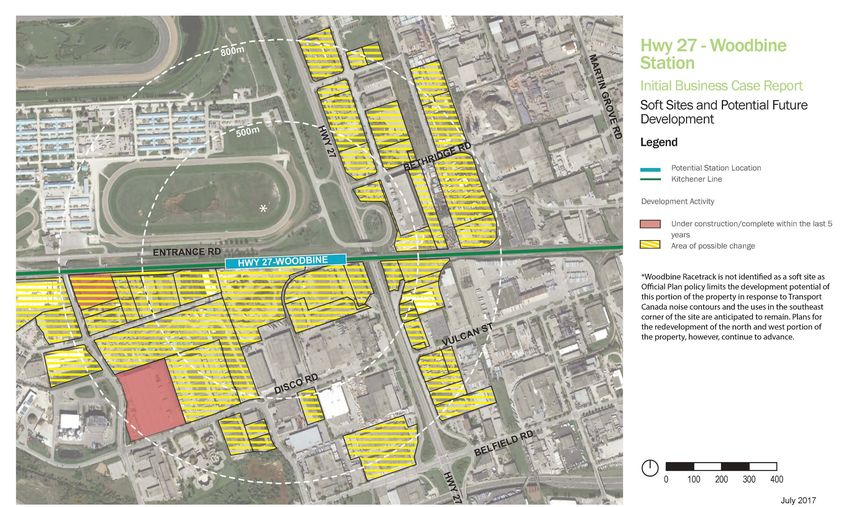
Figure 3-5 shows identified soft sites within 800 m of the station site. Each soft site has been categorized by its
land use designation in Toronto’s Official Plan, resulting in the following table of lands with potential to redevelop
over time:
Land use designation Total area of soft sites within 800 m
Regeneration Areas 0.00 ha
Employment Areas 98.36 ha
Mixed Use Areas 0.00 ha
Residential Areas 0.00 ha
Appropriate floor space index precedents, including built and proposed developments, have been used to
determine potential GFA yields for these soft sites over time:
Type of use Total area of soft sites within 800 m
Office/Employment 574,641 sq. m
Retail/Commercial 0 sq. m
Residential 0 sq. m
If all of the building space within these development applications and all of the development potential within
these soft sites were to be realized, the station’s catchment area would be expected to increase by 8,300 jobs.
November 2018 20NEW STATION BUSINESS CASE
HIGHWAY 27-WOODBINE
Figure 3-4: Existing Land Use
November 2018 21NEW STATION BUSINESS CASE
HIGHWAY 27-WOODBINE
Figure 3-5: Current Development Applications and Potential Soft Sites
November 2018 22NEW STATION BUSINESS CASE
HIGHWAY 27-WOODBINE
3.2.3.3 Real Estate Market Demand
Relationship to Current Market Demand
The airport office submarket has approximately 12.1 million sq. m of office inventory, with only modest levels of
absorption over the past five years. Moreover, Class A office space vacancy is high at 14% (relative to an overall
GTA average of 8%). The high vacancy rate is partly a result of office demand shifting from suburban markets to
the Downtown Toronto market.
The station itself is not well-situated relative to current office employment market demand. Only 9,200 sq. m of
major office space exists within the catchment area. Moreover, the area is zoned for heavy industrial uses and as a
result, no new office completions have taken place over the past five years.
The station is very well-situated relative to current industrial market demand. The catchment area contains
475,000 sq. m of inventory. Even though no new supply has been added in the last five years within the
catchment area, some development has taken place in proximity to it (10,000 sq. m). Moreover, the catchment
area enjoys good access to the airport as well as Highways 427 and 401, which are important industrial site-
selection attributes.
The station is not well-situated relative to current retail market demand. This is demonstrated by the fact that
there is no significant retail shopping centre space within the catchment area, and that no new retail shopping
centre space has been developed over the past five years.
The station is similarly not well situated to current residential condominium demand. The broader Etobicoke
North submarket has experienced a modest level of sales over the last five years (60 units per annum). Moreover,
there are only two active marketing projects within this broad market. There are no units proposed within the
catchment area itself. Lanterra Developments is proposing a 2,000-unit project at the intersection of Eglinton
Avenue and Royal York Road which may provide significant competition to any projects within the catchment
area and the broader Etobicoke North submarket.
Relationship to Future Market Demand
There is approximately 575,000 sq. m of employment development potential in properties identified as “soft
sites” within the catchment area. This development potential will likely be in the form of industrial uses due to the
nature of existing land use designations as well as the relative strength of the industrial market within the
catchment area.
The station is not currently well-situated relative to likely future retail and residential demand. There is no
development potential on any existing soft sites due to existing land use designations and Site and Area Specific
Policies. Moreover, the existing inventory for these uses is limited making the catchment area less desirable from
a site selection perspective.
There is a proposal for significant redevelopment of the Woodbine Racetrack property; however, the proposal
maintains the existing practice track and racing support facilities in the southeast portion of the site. The majority
of the redevelopment is planned to occur to the north, outside of the 800m station catchment area.
3.2.3.4 Natural Environment
The station site is within 800 m of Toronto’s Natural Heritage System, specifically the Mimico Creek Watershed,
which is also a Toronto and Region Conservation Authority (TRCA) Regulated Area. As per Ontario Regulation
166/06, development of and interference with regulated wetlands, shorelines, watercourses, and areas subject to
flooding may be restricted. The site is not near any Areas of Natural and Scientific Interest.
November 2018 23NEW STATION BUSINESS CASE
HIGHWAY 27-WOODBINE
3.2.4 Network, Connectivity, and Accessibility
The following criteria examine how the new station could connect and interact with existing and planned transit
and active transportation networks and surrounding land uses. They also describe the general ridership potential
for the new station.
3.2.4.1 Operational System
The proposed Highway 27-Woodbine Station would be located approximately 3.3 km from the existing Malton
GO station to the west, approximately 6.7 km east of Weston GO station and 20 km from Union Station.
3.2.4.2 Connectivity and Ridership Drivers
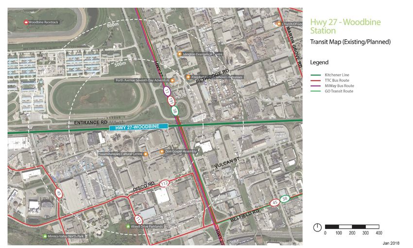
Transit
There are numerous TTC bus routes which operate in the vicinity of the station location, serving the surrounding
industrial area and Woodbine Racetrack. The 37A Islington bus route provides local service between Islington
Station and Woodbine Racetrack. The 45B Kipling bus provides limited service between Kipling Station and the
Atwell Drive industrial area via Belfield Road, with a stop at Highway 27, approximately 800 m south of the station
location. The 112C West Mall bus also provides service to the Atwell Drive industrial area, with a stop
approximately 800 m south of the station location at Belfield Road and Brockport Drive.
Metrolinx also operates a limited Bolton/Malton/North York GO bus route in the vicinity of the station area. This
route, which includes stops at York Mills Bus Terminal, Yorkdale Bus Terminal, Etobicoke North GO station, and
Malton GO station, operates along Highway 27 with a stop at Humber College Boulevard, approximately 2.9 km
north of the station location.
The City of Mississauga operates the MiWay 11 Westwood bus route between Islington TTC station and
Westwood Mall, with stops along Highway 27 both north and south of the station site. The 11B Westwood-
Nashua bus provides additional rush hour service along a similar route.
Consideration for future connections on this site may also include UP Express, a Finch West LRT extension, and
proposed high speed rail along the Kitchener corridor.
Destinations
There are six local destinations within 800 m of the station site. In addition, the station would serve one
destination of city-wide significance – Woodbine Racetrack. A full list of destinations follows:
• Sports & Entertainment • Place of Worship
1. Woodbine Racetrack & OLG Slots 1. Kingdom Hall of Jehovah’s Witness
• Community/Park 2. Islington Evangelical Centre
1. Mimico Valley North Park 3. Perth Avenue Seventh Day Adventists
2. Attwell Drive Parklands 4. Zion Gospel Assembly
In addition, Humber College and University of Guelph-Humber are major drivers beyond the 800 m station area.
Active Transportation
November 2018 24You can also read