Impact of the 1815 Tambora Eruption to global climate change
←
→
Page content transcription
If your browser does not render page correctly, please read the page content below

IOP Conference Series: Earth and Environmental Science

PAPER • OPEN ACCESS

Impact of the 1815 Tambora Eruption to global climate change
To cite this article: Achmad Djumarma Wirakusumah and Heryadi Rachmat 2017 IOP Conf. Ser.: Earth Environ. Sci. 71 012007

View the article online for updates and enhancements.

                              This content was downloaded from IP address 46.4.80.155 on 19/10/2021 at 00:54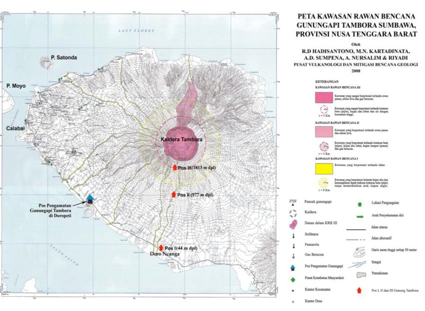
2nd Transdisciplinary Research on Environmental Problems in Southeast Asia                 IOP Publishing
IOP Conf. Series: Earth and Environmental Science1234567890
                                                  71 (2017) 012007      doi:10.1088/1755-1315/71/1/012007

Impact of the 1815 Tambora Eruption to global climate
change

                     Achmad Djumarma Wirakusumah1 and Heryadi Rachmat2
                     1
                       Institute of Energy and Mineral, Ministry of Energy and Mineral Resource, Jalan
                     Gajahmada 38, Cepu, Blora, Central java, Indonesia
                     2
                       Geological Museum, Geological Agency, Ministry of Energy and Mineral Resource,
                     Jalan Diponegoro No.57, Bandung, Jawa Barat, Indonesia
                     E-mail: ade.wirakusumah@gmail.com

                     Abstract : Tambora volcano is located at Sumbawa island, Indonesia. Geological study shows
                     a successive of geomorphological development of Tambora Volcano. During 190 to 86 K-
                     Years BP, shield-like or effusive volcano were formed; During 86 to 4 K-Years BP, a strato or
                     explosive-volcano was formed; However, during 80 to 4 K-Years BP flank eruptions occurred
                     intermittently and cinders were formed; In April 1815, a paroxysmal destructive eruption
                     occurred which were followed by caldera forming; Since 1815, lava domes and solphataric
                     fields were formed. The 1815 Tambora eruption emitted 60 to 80 megatons of SO 2 to the
                     stratosphere (44 km high). The SO2 spread the tropics, circled the world and it was oxidized to
                     form H2SO4 so called sulphate aerosols protecting the sunlight to reach the earth surface
                     causing global change effects. The Year of 1816 as the year without summer in Europe, the
                     depressed situation in Europe, the epidemic disease of Benggal were three of examples of the
                     impacts of the 1815 Tambora paroxysmal eruption. Therefore, characteristics of Tambora
                     activity before paroxysmal should be learned for mitigation purposes.
                     Keywords : paroxysmal eruption; caldera forming; global climate change.

1. Introduction
Tambora Volcano, Sumbawa Island, West Nusa Tenggara, Indonesia is geographically located at the
middle of the 7000 km long Indonesian volcanic belt (Figure 1). The volcanic belt lies starting from
Aceh of the North Sumatera continue to volcanoes along the west side of Sumatera towards the south,
continues to volcanoes along Java island from west to east, continues to volcanoes on Bali and Nusa
Tenggara islands, volcanoes on the East Nusa Tenggara islands, continues to volcanoes on Banda Sea,
and continues to volcanoes on Maluku islands and North Sulawesi. A number of 127 active volcanoes
are located in Indonesia, that means about 13 % of active volcanoes all over the world are located in
Indonesia. The volcanic belt of Indonesia is a part of the Pacific Ring of Fire (Figure 2) including New
Zealand and North America and South America [1].
   According to the data base of active volcanoes in Indonesia [2], there are 3 Indonesian active
volcanoes showing catastrophic eruption producing caldera (7 km in diameter) during the human life
history. They consist of Tambora in 1815, Rinjani in 1257, and Krakatau in 1883. Tambora is a strato
volcano with a caldera morphology that was caused by a production of a catastrophic eruption in 1815
[2]. According to the human life history, the 1815 Tambora Eruption is the biggest eruption in the
world, resulting totally more than 200,000 people dead at around the volcano and many parts of the
world, and damages of many kinds of casualties locally, regionally, and globally [1] and [2]. No

              Content from this work may be used under the terms of the Creative Commons Attribution 3.0 licence. Any further distribution
              of this work must maintain attribution to the author(s) and the title of the work, journal citation and DOI.
Published under licence by IOP Publishing Ltd                          1
2nd Transdisciplinary Research on Environmental Problems in Southeast Asia                 IOP Publishing
IOP Conf. Series: Earth and Environmental Science1234567890
                                                  71 (2017) 012007      doi:10.1088/1755-1315/71/1/012007

                                                                                0     10,000 km

  Figure 1. Location map of Tambora Volcano              Figure 2. Pacific Ring of Fire, including all
    among the Indonesian active volcanoes.                       volcanoes in Indonesia [1].

adequate volcanic mitigation facility was applied at Tambora volcano in 1815, and no responsible
institution took care of active volcanoes in Indonesia at that time. Consequently, no volcanic
information concerning the 1815 Tambora Eruption could be distributed to all people all over the
world, nor within in Indonesia at that time.
   Learning from the 1815 Tambora Volcano eruption event is very important to study as a part of the
volcanic mitigation study in Indonesia and all over the world. That is why, this study will be focused
into geological condition especially before, during, and after the Tambora 1815 eruption occurred,
how strong the 1815 eruption was, what is the effect of the catastrophic eruption to the world, what
kind of method and management that can be applied for volcanic mitigation purposes at Tambora
active volcano.

2. Data and Method.
No one knew that Tambora would erupt catastrophically in the world even in Indonesia before the
eruption occurred. Only some people heard that a very big blasting sound at far away from Sumbawa
(at Bengkulu, Sumatera island, 1775 km away, also Ternate, Maluku islands, 1400 km away) and
some looked directly at the giant eruption of Tambora volcano in April 1815 at areas close to the
volcano. A huge number of evens were not understandable in the world for several years after 1815,
although finally a lot of people in the world knew after more than 6 decades that the cause of those
events were actually the results of the 1815 eruptions of Tambora volcano.
    By learning a similar activity to the 1815 Tambora that can be happened in the future at Tambora
volcano or any volcano in Indonesia even all over the world, some methods in this study were carried
out as follows.
    The method was firstly preceded by a detailed geological study of Tambora volcano through a
geologic map study of the volcano especially using volcanic-stratigraphy method. This study can be
followed by making its Volcanic Hazard Map. Secondly, a collecting of technically by finding
authentic information of deposits of Tambora eruption products all over the world was conducted.
Thirdly, collecting several non-technically information by finding some prooven histories through any
kind of mass media from all over the world that could be related with the 1815 Tambora eruption were
also conducted. Study and realization of proposed plans concerning the Tambora volcano Mitigation
were also carried out.

3. Result and Discussion.

3.1. Geology of Tambora Volcano.

                                                    2
2nd Transdisciplinary Research on Environmental Problems in Southeast Asia                 IOP Publishing
IOP Conf. Series: Earth and Environmental Science1234567890
                                                  71 (2017) 012007      doi:10.1088/1755-1315/71/1/012007

Tectonically, Tambora volcano includes volcanoes on Sumatera, Java, Bali, West Nusa Tenggara, and
East Nusa Tenggara were closely related with the collision between the Indian-Australian Ocean Plate
from the South and the European Continental Plate from the North. The collision part is tilting towards
the north. A partial melting generates a molten rock of magma produced volcanic rocks, so called
Tambora volcano. Tambora is located at a very complicated tectonic position generates the magma
moves towards the surface.
    A classification of Volcanic Stratigraphy Unit level based on volcanic eruption source, geography,
and tectonic setting was introduced [3]. The classification consist of Volcanic Bregada, Volcanic
Khuluk, Volcanic Gumuk, and Volcanic Manggala. Volcanic Khuluk is a basic unit in grouping a
volcanic stratigraphy unit for volcano, i.e Volcanic Khuluk Tambora. Volcanic Gumuk is a part of the
Volcanic Khuluk which was formed as eruption products on the Volcanic Khuluk both for central or
flank eruptions, i.e Volcanic Gumuk Apitoi, Volcanic Gumuk of Katupa etc. Volcanic Bregada is a
volcanic stratigraphic unit covering volcanic eruption products originating from two or more Volcanic
Khuluk or related to a caldera forming. The volcanic Bregada always has a Volcanic Khuluk or more.
    According to the Geological Map of Tambora Volcano complex (Figure 3) [4], which is combined
with the implemented Volcanic Stratigraphy Unit Level [3] at Tambora, the Geological History of
Tambora volcano forming can be explained as follows. A simple and general geological history
sequantly based on the Volcanic Stratigraphy Unit Level of Tambora is showed in Figure 4.
    A great volcanic complex of Tambora which is located on Sumbawa island at 50 to 100 km north-
west ward from Dompu, was preceded by forming a large volcano complex on a large area namely
“Volcanic Bregada of Sanggar”. The Volcanic Bregada was formed at least 690 KY BP consist of
firstly, “Volcanic Khuluk of Labumbum” (690 – 410 KY BP) at the south-east part of the Volcanic
Bregada, lithologically consisting of lava flow and pyroclastic rocks (andesitic in composition);
secondly, “Volcanic Khuluk of Kawinda Toi” (410 – 190 KY BP) at the north-east part, lithologically
consisting of lava flow and pyroclastic rocks with basaltic in composition; and thirdly, “Volcanic
Khuluk of Tambora” (190 KY BP – now) at the center of the Bregada, lithologically consisting of
lava flow and pyroclastic rocks (andesitic to andesitic basalt in composition). During the activities

                          Figure 3. Geological map of Tambora volcano [4].

                                                    3
2nd Transdisciplinary Research on Environmental Problems in Southeast Asia                 IOP Publishing
IOP Conf. Series: Earth and Environmental Science1234567890
                                                  71 (2017) 012007      doi:10.1088/1755-1315/71/1/012007

  Figure 4. A Simple and General Geological             Figure 5. Stratigraphy coloum of the eruption
 History of Tambora Volcano Complex based on            products during the 1815 Tambora activity [1].
 Volcanic Stratigraphy Level Unit, sketched by
                 Wirakusumah.

through Tambora vent to form strato volcano, eruptions were also intermittently occurred between
central eruption (Tambora crater) and the flank eruption starting from 80 KY BP, producing 40 cinder
cones at all directions of Tambora flank especially at elevation between 0 and 1600 m asl.
Lithologically, they consist of lava flow, pyroclastic crocks, phreatomagmatic, and phreatic eruption
products. On the body of Kawinda Toi, two small flank eruptions were formed in 80 KY BP, that
means they were formed during the Volcanic Khuluk of Tambora forming. According to the Volcanic
stratigraphy [3], these flank eruptions are called “Volcanic Gumuk” e.i “Volcanic Gumuk of Katupa”
as the child of the Volcanic Khuluk Tambora which is located on the Kawinda Toi body. The youngest
Volcanic Gumuk of Tambora is the Volcanic Gumuk of Api Toi as central eruption which was
produced after the 1815 Tambora eruption (between 1847 and 1914). This volcanic complex lies on a
Late Tertiary sedimentary rocks consisting of mainly limestones (about 12 to 15 Million years ago) as
the basement.
    According to the data above, there were two times of the main central eruption sources shifting
within the Volcanic Bregada of Sanggar. The eruption source were firstly at around Labumbum
Volcano body (690 KY BP), secondly the eruption source moved to around Kawinda Toi Volcano
body (410 KY BP), and finally the eruption source moved to Tambora Volcano (since 190 KY BP).
The formed 40 cinder cones on around the Tambora flank especially produced freatomagmatic
materials indicates that when magma were came up towards the Tambora flank surface through some
diatremas, the magma or the magma heat contacted water (ground water originated from sea water or
land ground water) producing freatomagmatic eruptions and some of them are produced freatic
eruptions. Another explanation, that when lava flows were contacting ground water, then
phreatomagmatic or phreatic eruptions occurred.
    Oldest period of Tambora lithology (pre-caldera forming) were dominated by andesite basalt to
basaltic-andesite lava with 49 to 53 % SiO2 content. These lava flows formed between 190 KY BP and
9 KY BP covering older rocks. This condition effect to form Tambora morphology of a shield
volcano. However, starting 86,000 years some pyroclastic rocks were found producing a strato
volcano characteristic. This indicates that there were shifting from lava dominantly (effusive eruptive

                                                    4
2nd Transdisciplinary Research on Environmental Problems in Southeast Asia                 IOP Publishing
IOP Conf. Series: Earth and Environmental Science1234567890
                                                  71 (2017) 012007      doi:10.1088/1755-1315/71/1/012007

characteristics) to an intercalation between effusive and explosive eruptions. This effect that Tambora
shows a break slope to be a steeper slope at elevation of 1,800m asl, event such kind condition was
continued reaching up to an extrapolation elevation of 4,200 m asl [4]. No eruption activity during a
big gap of age (between 4000 years BP and the year of 1815) was recorded, that probably means
during about 2000 year the Tambora had been building energy which was finally in 1815 the Tambora
produced a catastrophic eruption producing a great caldera (diameter = 7 km). A stratigraphic coloum
of the 1815 Tambora eruption product is shown in Figure 5 [1].

3.2. Magnitude and Ditribution of the Eruption.
Tambora erupted catastropically in 1815. The detail chronology of the eruption is shown in the Table
1.

    Table 1. The detail chronology of the 1815 Tambora eruption based on the eye witnesses [1].

              DATE            TIME                               OBJECT                                            COMMENTS

              (1812)        A few days     Black ash eruption column from the summit               It indicated the Pre-initial phase.
                                           accompanied by rumbling.
              April 5        Sun set       34 m high black eruption column. The eruption sound     The main eruption produced loud sounds due
                                           were heard for several times from Jakarta, Makasar,     to the partial destruction of lava plug.
                                           and Ternate.

             April 6-9      Afternoon      Ash fell on Surabaya (600 km to the west) for 4 days.   The wind blew from east to Wrest-Northwest,
                                                                                                   to Java.

             April 10       19:00 pm       Fire column rose from 3 places, followed by glowing     Stage of collapse of the Tambora summit
                                           ash looked like fire.                                   part.

                            20:00 pm       The three ash column was calesced, and were             This stage is the strongest stage producing
                                           followed by a total fire covering all summit until      pyroclastic flow.
                                           flank area. Glowing rocks fell at 20 km away from
                                           the summit.

                          21:00-22:00 pm   Volcanic ash & strong wind from all directions. The     High velocity Turbulence wind indicate
                                           explosion sound was heard from Jakarta.                 thepyroclastic flow (V = 80 km/hour)

                            22:00 pm       Tsunami (4 m high) at Sanggar coast.                    Pyroclastic flow reached the coast and
                                                                                                   generated tsunami (4 m) at Sanggar and at
                            24:00 pm       2 m di Jatim dan Maluku.                                East Java (2 m) & Maluku islands (2m).

             April 11       07:00 am       Erption continued. The summit was claudy.               Paroxismal terminated. Eruption decreased.

                            13:00 pm       Darkness for few days.                                  Ash covered sun ray.

                             22:00pm       Ash fell on Java for 3 days.                            The wind blew to the west and northwest.

                            24:00 am       Eruption decreased significantly.                       Magma began to retreat.

            April 12-17     All the day    Ash fell on Java. Eruption terminated on17/4            Magma retreated& Eruption terminated.

   The 1815 Tambora eruption produced a number of > 100 km3 of ejected material [2] and Volcanic
Explosivity Index (VEI) of 7 from the highest scale of 8. Comparing to some other big volcanic
eruption of many volcanos in the world based on the ejected eruption material, the 1815 Tambora
eruption is classified into very large eruption that is illustrated in Figure 6 [5].
   The 1815 Tambora eruption sound was heard from Bengkulu (> 1700 km to the west), Makasar
(400 km to the north), Ternate island (> 1400 km to the north east). The ejected material of the 1815
Tambora eruption was probably reached 44 km high vertically [1] that means reaching the stratosphere
layer. The volcanic ash was pushed by the wind blowing to the west-northwest as illustrated by Figure
7 [6]. The plume was probably circling over the earth globe for years. This indicates that the volcanic
ash originated from the 1815 Tambora eruption was deposited all over the world.
   The 1815 Tambora eruption emitted 60 – 80 megatons of SO2 (sulfur dioxide) to the stratosphere,
which means 3-4 times as much as during the 1991 Pinatubo of the Philippines the biggest eruption of
the 20th century [7].

                                                                               5
2nd Transdisciplinary Research on Environmental Problems in Southeast Asia                 IOP Publishing
IOP Conf. Series: Earth and Environmental Science1234567890
                                                  71 (2017) 012007      doi:10.1088/1755-1315/71/1/012007

      Figure 6. A Volcanic Explosivity Index has          Figure 7. Map of volcanic ash movement
       been proposed in 1982 [5]. (The source of         originated from the 1815 Tambora eruption
          figure: www.volcanoes.usgs.gov).                                   [6].

   In the stratosphere, the SO2 spread across aerosol the tropics, circled the globe and was oxidized
within weeks to form H2SO4, a substance that condenses to tiny droplets called sulphate aerosol. These
aerosols dimmed the sunlight and primary caused to the global climatic effects. The case of Tambora
can be explained that the ejected ash and gases reaching the stratosphere, which after 2 weeks the
suphur gases circled the tropics in Stratosphere. After 8 weeks they were rapidly oxidized to Sulphate
Aerosols, and after 1 year the Aerosols slowly spread poleward [7]. That is why the aerosol originated
from 1815 Tambora eruption was found in the ice core in Greenland. This means that the product of
the 1815 Tambora eruption spread to all over the world.

3.3. The Impact of the 1815 Tambora Eruption.

3.3.1. The Impact of Pyroclastic Flow
Three kingdoms on Sanggar Peninsula close to Tambora volcano so called Kingdoms of Pekat,
Tambora, and Sanggar were destroyed because of the 1815 Tambora eruption through pyroclastic flow
deposit and tsunami. A total number of fatalities in these location of 10,000 people died directly was
reported [1].
   The other impact of the pyroclastic flow was the vanishing of houses, villages, cities, as well as
kingdoms at Sanggar peninsula, consequently the population and its culture and language were also
perished. A lot of folklore and caesura concerning all those stories were collected. One of great
evidences is an ancient manuscript telling about the 1815 Tambora eruption written in Melayu
laguange in Arabic character which is now is kept by Dr. Hj. Maryam S, a philologist in Sumbawa.
   Some excavation of locations suspected as buried artifacts were carried out revealed those things
including human remnant were really vanished and buried. That is why it is called as “The Pompeii of
the East” (Figure 8).

3.3.2. The Impact of Pyroclastic Fall.
In other place on Sumbawa island such as at Dompu Kingdom, at Bima Kingdom, and at Sumbawa
Kingdom, some 38,000 people died indirectly through starvation and disease. Starvation and disease
were appeared after the pyroclastic fall deposit originated from the eruption destroyed all plantation
including agriculture belong the people or government. Consequently, food and many important things
were difficult to provide. This resulted the Sumbawa’s inhabitants reduced for about 50 % (Figure 8).

                                                    6
2nd Transdisciplinary Research on Environmental Problems in Southeast Asia IOP Publishing
IOP Conf. Series: Earth and Environmental Science1234567890
71 (2017) 012007 doi:10.1088/1755-1315/71/1/012007
Starvation and disease conditions also occurred in Lombok and Bali islands resulting a number of
44,000 people died in Lombok and that of 25,000 in Bali. Consequently, The total fatalities (directly
and indirectly) in Indonesia was 117,000 people [1].
TYPE OF TAMBORA
ERUPTION PRODUCTS
PYROCLASTIC FLOW PYROCLASTIC FALL ASH INJECTED TO THE
STRATOSPHERE
impact
impact
Three Kingdoms Starvation at Cold Weather; years without
(including Culture Sumbawa, summer and the change of
and Language) Lombok and Bali
Vanished
climate pattern.
islands.
impact Napoleonic war terminated
restored the peace
History caesur Exodus
impact The Year of Beggar in
Germany
Pompei of the East Sumbawa
inhabitants were
Exodus to West Frontier
reduce by 50% (USA), Establishment of New
State.
Starvation in Yunnan, China The 1819 crisis, ten banks
Opium War. bankrupted in USA
Typhus in Ireland
Cholera epidemic Benggal, India
Spread over the World.
Frankenstein and
Vampire Lord Byron’s
Darkness
Figure 8. Schematic global impact of the 1815 Tambora eruption, modified from [1]
3.3.3. The Impacts of the Injected Ash to Stratosphere.
A number of thousands of people were died indirectly in Ireland (Europe) because of Typhus and food
shortages. In Yunnan, China, a number of tens of thousands were died indirectly because of starvation
and chilling summer. Another place, in Bengal, India, a number of ten thousands of people died
indirectly caused by Cholera due to abrupt change of weather (Figure 8). The total fatalities in the world
was > 200,000 people [1].
As it has been explained that a year after the 1815 Tambora eruption, the aerosol which was
originated from Tambora eruption covered all of the globe. The aerosol became an obstacle for the sun
ray to reach the ground surface freely. Consequently, the sky never showed a sunny day, people feel
the weather on the earth very cold any where and every time especially at sub-tropic areas.
72nd Transdisciplinary Research on Environmental Problems in Southeast Asia IOP Publishing
IOP Conf. Series: Earth and Environmental Science1234567890
71 (2017) 012007 doi:10.1088/1755-1315/71/1/012007
The global temperature in the world dropped 1º to 2.5º C and in some place reached 10º C. That is
why in 1816 is called as “The Year without a summer” in Europe as well as in USA although a year
after, the summer did not appear yet at both places [1]. This condition finally changed the climate
pattern in the world.
The changed climate pattern resulted a lot of odd phenomenon but also a wisdom or philosophy
such as rainy, cold and dry resulting the crops did not grow, the harvest failed, and food (including
animals) shortages everywhere included in European countries, Asian countries, and USA. In
Germany flood occurred along Rheine River caused food shortages in many cities the river’s banks. In
Britain and Ireland weather so cold, snow fell down. The starvation spread over the South Ireland. In
1816, typhus epidemic broke out in Ireland. The American sky was disturbed by the eruption ash of
Tambora resulting the climate changed significantly in 1816. A lot of harvest failed and many of the
farmed animals dead. Some of the arriving immigrant had to turn back to Europe because of food
shortages condition occurred in the USA.
3.4. Volcanic Hazard Mitigation
Volcanic Hazard mitigation before, during and after the eruption should be done for reducing the
volcanic risk purposes.
Volcanic Hazard mitigation activities consist of:
- Identification of volcanic activity
- Volcanic monitoring
- Establishing a statement of activity level of the volcano
- Volcanic Hazard Mapping
- Geological Mapping of the volcano
- Socialization concerning the development of volcanic activity
- Technical Reporting and based on Law Number 24 concerning Disaster Mitigation in
Indonesia.
- Coordinating with the National Agency of the Natural Disaster Mitigation of Indonesia.
Volcanic Hazard Mitigation is technically preceded by volcanological study through methods of
geology, geophysics, geodesy, geochemistry. To reduce a risk of volcanic hazard such as Tambora
Figure 9. Volcanic Hazard Map of Tambora Volcano [8].
82nd Transdisciplinary Research on Environmental Problems in Southeast Asia IOP Publishing
IOP Conf. Series: Earth and Environmental Science1234567890
71 (2017) 012007 doi:10.1088/1755-1315/71/1/012007
volcano, a geological study is required as Tambora shows short and long periods of repose time.
The long period of repose time can be studied based on data base along the human life history, but
it is probably also required a carbon dating method through rock samples to understand the age of the
eruption products. This should be related with the magma composition chemically through studying on
every eruption product. This will help to understand the characteristic and volcanic forming history. A
catastrophic eruption like the 1815 Tambora eruption is usually preceded by having a long repose time
and changing of magma composition chemically.
The short period of repose time can be studied by geology, geochemistry and geophysics including
geodesy. The integrated data of them will help in making decision of the volcanic activity as this
information will be taken as a reference to act the following mitigation activity.
Volcanic hazard mitigation for Tambora volcano need to make 2 versions both for long and short
periods. The Volcanic Hazard Map of Tambora Volcano (short period) is shown in Figure 9 [8].
4. Conclusion.
The 1815 Tambora catastrophic eruption with VEI of 7 resulted a great hole 7 km diameter and 1 km
depth so called Tambora Caldera. The ash plume reached stratosphere, 44 km high covering all over
the world for few years.
The 1815 Tambora eruption impacted a lot of fenomenon in the world especially the changed
climate pattern to the globe such as the 1816 is called as The Year Without a Summer etc. The
eruption was finally resulting a number of > 200,000 people dead all over the world.
Tambora volcano is a good example volcano to study in Indonesia even in the world as the volcano
has 2 kinds of eruption characteristics which are related to a long period repose time and a short repose
period, and having changing in magma chemical composition. Until now, the 1815 Tambora is
classified as the most catastrophic eruption in the world within the human life history. Research and
collecting information of Tambora volcano globally should be continued in order to make the data
base more complete. Information of the volcano should be distributed to the involved institutions for
volcanic mitigation purposes. This methods can be applied to study other volcanos in Indonesia even
in the world.
References.
[1] Sudradjat A and Rachmat H 2015 Greetings from Tambora A Potpourri of the Stories on the
Deadliest Volcanic Eruption, Geological Museum, Center for Geological Survey, Geological
Agency, Bandung, Indonesia, 173 p.
[2] Geological Agency, Ministry of Energy and Mineral Resources of Indonesia 2011 “Data Dasar
Gunung Api Indonesia”, Bandung, 2nd Edition, p : 47-59.
[3] Wirakusumah A D, Bacharudin R, Sujanto, Bronto S, 1997 Satuan Stratigrafi Gunungapi
Indonesia, Direktorat Vulkanologi, Direktorat Jenderal Geologi dan Sumber Daya Mineral,
Departemen Pertambangan dan Energi, Bandung, 7 p.
[4] Kartadinata M N, Mulyana A R, Kriswati E and Haerani N 2008 Geological Map of Tambora
Volcano, Sumbawa, West Nusa Tenggara, Indonesia, 1 : 100,000, Center for Volcanology and
Geological Hazard Mitigation.
[5] Newhall C G and Self S 1982 The Volcanic Explosiovity Index (VEI): an estimate of explosive,
magnitude for historical volcanism. J. Geophys Res 87: 1231-1238.
[6] Sigurdsson H, Carey S, and Erfan R D 1986, The Deposits from the 1815 Tambora Eruption:
Preliminary.
[7] Bronnimann S and Kramer D 2016 Tambora and the “Year Without a Summer” of 1816 A
Perspective on Earth and Human Systems Science, Institute of Geography, University of Bern,
Switzerland , 48 p.
[8] Hadisantono R D, Kartadinata M N, Sumpena A D, Nursalim A and Riyadi 2008 Vocanic Hazard
Map of Tambora Volcano West Nusa Tenggara.
9You can also read