Atlas of Missouri Amphibians and Reptiles for 2020 - Richard E. Daniel and Brian S. Edmond
←
→
Page content transcription
If your browser does not render page correctly, please read the page content below
Atlas of Missouri
Amphibians and Reptiles
for 2020

  Richard E. Daniel and Brian S. Edmond
Atlas of Missouri
Amphibians and Reptiles
for 2020
Richard E. Daniel
Division of Biological Sciences
University of Missouri-Columbia
114 LeFevre Hall
Columbia MO 65211
danielr@missouri.edu

Brian S. Edmond
Computer Services
Missouri State University
901 South National Ave
Springfield MO 65897
BrianEdmond@missouristate.edu

Recommended citation:

Daniel, R.E. and B.S. Edmond. 2021.
Atlas of Missouri Amphibians and Reptiles for 2020.

Updated: 08 April 2021 17:58
Copyright (C) 1997-2021. All rights reserved.
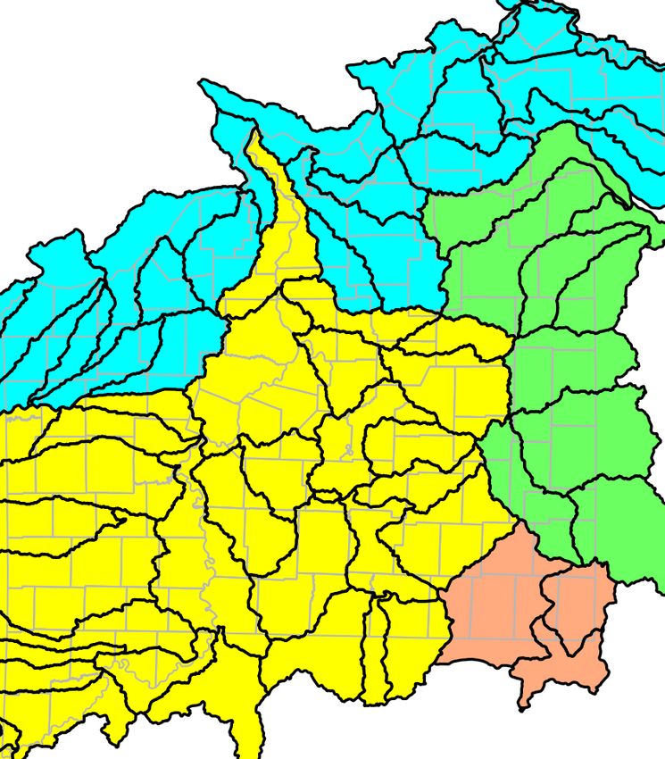
Table of Contents
Table of Contents
Introduction . . . . . . . . . . . . . . . . . . . . . . . . . . . . . . . . . . . . . . 3
Nomenclature and Taxonomy . . . . . . . . . . . . . . . . . . . . . . . . . . . . 3
Amphibians and Reptiles of Possible Occurrence . . . . . . . . . . . . . . . . 4
Erroneously Reported and Non-Native Species . . . . . . . . . . . . . . . . . . 5
County Records . . . . . . . . . . . . . . . . . . . . . . . . . . . . . . . . . . . . 5
Distributions . . . . . . . . . . . . . . . . . . . . . . . . . . . . . . . . . . . . . . 5
Terrestrial Ecoregions . . . . . . . . . . . . . . . . . . . . . . . . . . . . . . . . 6
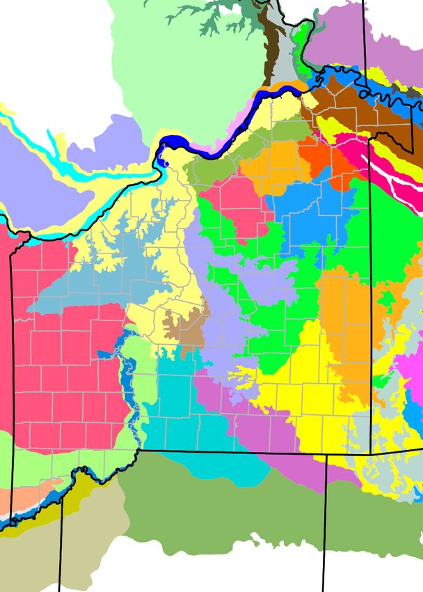
Aquatic Subregions . . . . . . . . . . . . . . . . . . . . . . . . . . . . . . . . . . 7
Natural Divisions and Sections Map . . . . . . . . . . . . . . . . . . . . . . . . 8
Level I Terrestrial Ecoregions Map . . . . . . . . . . . . . . . . . . . . . . . . . 9
Level II Terrestrial Ecoregions Map . . . . . . . . . . . . . . . . . . . . . . . . 10
Level III Terrestrial Ecoregions Map . . . . . . . . . . . . . . . . . . . . . . . 11
Level IV Terrestrial Ecoregions Map . . . . . . . . . . . . . . . . . . . . . . . 12
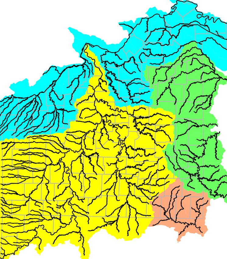
Rivers and Major Streams Map . . . . . . . . . . . . . . . . . . . . . . . . . . 13
Watershed Boundaries Map . . . . . . . . . . . . . . . . . . . . . . . . . . . . 14
Ecological Drainage Units Map . . . . . . . . . . . . . . . . . . . . . . . . . . 15
County and Surrounding States Map . . . . . . . . . . . . . . . . . . . . . . . 16
Species Locality Maps . . . . . . . . . . . . . . . . . . . . . . . . . . . . . . . . 17
County Records Maps . . . . . . . . . . . . . . . . . . . . . . . . . . . . . . . . 47
Acknowledgements . . . . . . . . . . . . . . . . . . . . . . . . . . . . . . . . . 77
Literature Cited . . . . . . . . . . . . . . . . . . . . . . . . . . . . . . . . . . . 77
Appendix A: Sources . . . . . . . . . . . . . . . . . . . . . . . . . . . . . . . . . 83
Atlas of Missouri Amphibians and Reptiles for 2020 2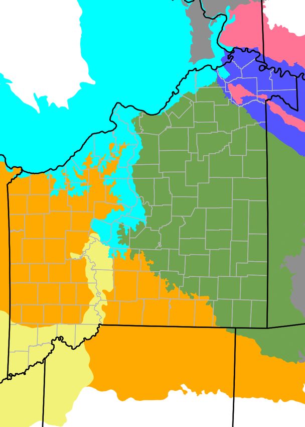
Introduction - Nomenclature and Taxonomy

                                                                         request. Readers may contribute new records and read more
Introduction                                                             about project details online (Edmond and Daniel 2021).
     Since 1988, members of the Missouri Herpetological                  Questions, comments, and suggestions should be directed
Association have compiled new county distribution records                to the senior author.
for amphibians and reptiles native to the state (Johnson and
Powell 1988; Powell et al.. 1989, 1990, 1991, 1992, 1993a,
1994, 1995, 1996, 1997; Daniel et al.. 1998, 1999; Daniel
                                                                         Nomenclature and Taxonomy
and Edmond 2000, 2001; Daniel et al.. 2002, 2003, 2004,                       Scientific and common names used in this publication
2005, 2006, 2007, 2008, 2009, 2010, 2011, 2012, 2013,                    follow Crother et al.. (2017). The chosen common name
2014, 2015, 2016, 2017, 2018, 2019, 2020). Cumulative                    represents the most restrictive name available and refers to
accounts of these new records were presented in Powell et                the subspecies found within the state of Missouri. If two or
al.. (1993b), Powell and Daniel (1997), and Daniel and                   more subspecies are recognized in the state, the species
Edmond (2002b). Johnson (2000) presented revised                         common name was used. Refer to Appendix B for a
distribution maps based on a combination of these                        complete list of scientific names and common names. Since
cumulative accounts and more recent annual compilations.                 the publication of Johnson (2000), several systematic
The publication of Johnson (1987, 2000) renewed interest                 studies have necessitated nomenclatural changes of some
in expanding our knowledge of the distribution of the state's            Missouri species.
herpetofauna. In order to provide herpetologists working in                   Frost et al.. (2006) concluded that several
Missouri with current information that is easily taken into              geographically widespread genera represented polyphyletic
the field, we are presenting revised species distribution and            groups. Their work necessitated the splitting of several
county records maps in a format that can be easily updated               familiar genera and applying new names to the species
as new records are documented.                                           found in Missouri. Missouri toads formerly placed in the
     In 1997, with the initiation of the Missouri                        genus Bufo have been reassigned to the genus Anaxyrus and
Herpetological Atlas Project (MOHAP), a database was                     true frogs of the genus Rana are now placed in the genus
established to serve as the basis for verifying new                      Lithobates.
distribution records and tracking changes in individual                       Two other formerly cosmopolitan genera, Eumeces and
species distributions within the state (Edmond and Daniel                Elaphe, have also undergone revision. Brandley et al..
2021). Qualification for inclusion in the database generally             (2005) resurrected the genus Plestiodon for the clade
requires a catalogued voucher specimen housed in an                      containing the North American skinks and Utiger et al..
institutional collection. However, in order to be valuable in            (2002) placed the North American ratsnakes of the genus
tracking changes in the distribution of individual species, it           Elaphe into the resurrected genus Pantherophis.
is important to document historical records. Many of the                      A study of the phylogeny of the racers restricted the
specimens collected prior to 1960, most notably those                    genus Coluber to the New World and also included the
reported by Hurter (1911) and Anderson (1965), were                      coachwhip and whipsnakes of the genus Masticophis (Nagy
documented by specimens that have since been lost or                     et al.. 2004). Reeder et al.. (2002) concluded from their
destroyed. In order to provide the most accurate picture of              phylogenetic study that the genus Cnemidophorus was not
the distribution of the state's herpetofauna we have included            a monophyletic assemblage. They presented evidence that
literature records that we believe to be valid.                          species in North America represent a distinct clade and
     Some records were not included because the                          reassigned all U.S. species to the resurrected genus
identification could not be determined with certainty.                   Aspidoscelis.
Within Missouri, the Hyla versicolor complex consists of                      Several studies at the species level have also required
two       broadly     sympatric       and     morphologically            changes in the nomenclature of some Missouri reptiles and
indistinguishable species (H. chrysoscelis and H.                        amphibians. Leaché and Reeder (2002) restricted
versicolor). Specimens collected prior to the separation of              Sceloporus undulatus to the Eastern United States.
the two species or those for which the species identification            Missouri populations formerly considered S. u.
was not determined by some non-morphological trait were                  hyacinthinus are now placed in S. consobrinus. Starkey et
not included.                                                            al.. (2003) determined that southern painted turtles
     Currently, the MOHAP database contains 37,808                       represented a distinct genetic lineage and elevated
entries and 33,670 valid, non-duplicated collections. This               Chrysemys dorsalis to a full species.
represents specimens housed in 37 museum collections and                      Using mitochondrial DNA in a range-wide
cited from 33 historical literature sources; 5,289                       examination of the Lampropeltis getula complex, Pyron
documented county records; 10,221 unique localities; and                 and Burbrink (2009) recovered five lineages that they
17,515 unique species / locality combinations. This new                  recognized as distinct species. The central lineage, found
total constitutes 2,902 new database entries since the 2019              west of the Mississippi River, was assigned the name of the
edition of the Atlas (Daniel and Edmond 2020). The total                 subspecies widely known in Missouri (speckled kingsnake)
number of species contained in the current edition of the                and is now known as L. holbrooki. More recently, we
atlas is 118, comprised of 116 native species and 2                      discovered two black kingsnakes (L. nigra) in southeast
non-native species.                                                      Missouri (Edmond and Daniel 2014). Because of dramatic
     Previous editions of the atlas (Daniel and Edmond                   shifts in the Mississippi River channel during the
2002a, 2003, 2004, 2005, 2006, 2008, 2010, 2012, 2013,                   Pleistocene, a significant portion of southeast Missouri (i.e.,
2014, 2016, 2017, 2018, 2019, 2020) are available upon                   Crowley's Ridge and east) was previously found on the
                                            Atlas of Missouri Amphibians and Reptiles for 2020                                             3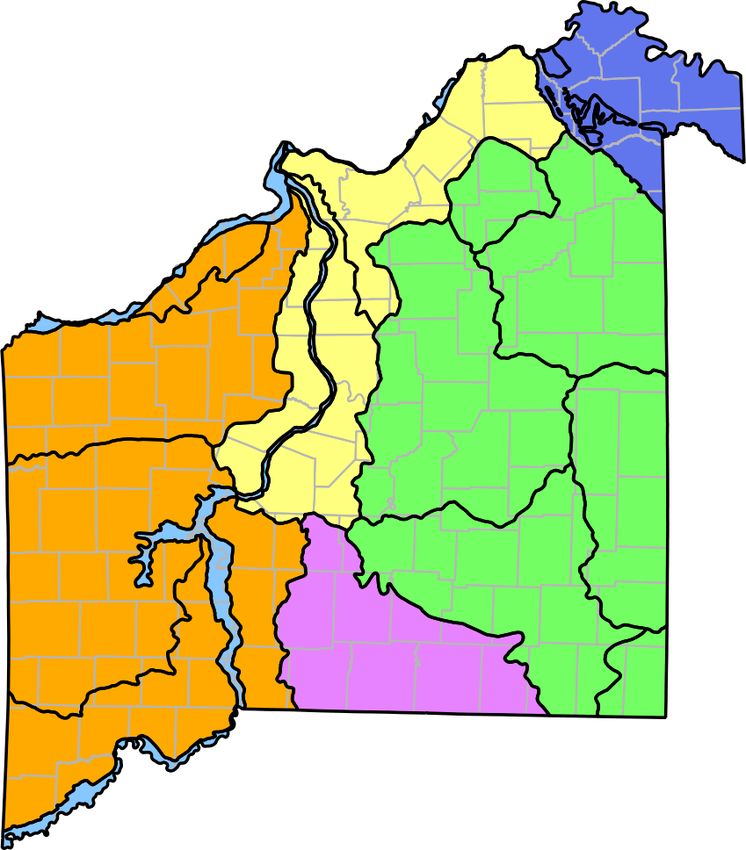
Amphibians and Reptiles of Possible Occurrence

eastern side of the river. Anderson considered at least some              populations, including Anderson's intergrades, are readily
specimens in southeast Missouri as hybrids with the                       assigned to the western massasauga (Sistrurus tergeminus)
speckled kingsnake (Anderson 1965). Thus, the kingsnakes                  (Gibbs et al. 2011). Unfortunately, animals from eastern
found in that part of the state are likely black kingsnakes or            Missouri populations have not been found in more than 75
hybrids with L. holbrooki.                                                years, making genetic analysis impossible. We elect to
     Gamble et al. (2007) provided molecular evidence that                follow Anderson and assign these likely extirpated
cricket frogs roughly north and west of the Ohio /                        populations to the eastern massasauga (Sistrurus
Mississippi River valleys, including all of Missouri, should              catenatus).
be considered a distinct species, Acris blanchardi. The                        Finally, Shulse (2006, 2007) discovered and described
common name Blanchard's Cricket Frog is adopted for this                  a new locality for Kirtland's Snake (Clonophis kirtlandii) in
species.                                                                  northeast Missouri. In 2007, another adult snake was found
     Lemmon et al.. (2007) examined the distributions of                  dead on a road in Marion County (Daniel 2007).
North American trilling chorus frogs based on genetics and                Previously, this species was known in the state from a
determined that Missouri populations formerly assigned to                 single Marion County record (Jones 1967). The lack of
the western chorus frog, Pseudacris triseriata, were                      additional specimens resulted in Johnson (1987, 2000)
actually the boreal chorus frog, P. maculata, and confirmed               listing this species as questionable or of possible
that the upland chorus frog, P. feriarum, of the Mississippi              occurrence in Missouri. The three recent discoveries and
Lowlands was a valid species. In addition, a new species of               the original historical record are included here as an
chorus frog, P. fouquettei, has been identified from the                  addition to the state's herpetofauna.
interior highlands and western coastal plain (Lemmon et
al.. 2008). Currently, this species is known from three
localities in Missouri. Nearby Ozark Plateau localities have
                                                                          Amphibians and Reptiles of
been tentatively assigned to P. feriarum but are likely to be             Possible Occurrence
reassigned to this new species pending further
investigation.                                                                 A number of species found in surrounding states are
     Bonett and Chippindale (2004) examined the                           known to occur in close proximity to the borders of
relationship among members of the Eurycea multiplicata                    Missouri. While not currently recognized as part of the
complex. They corroborated the conclusion of Thornhill                    Missouri herpetofauna, some or all of these species may
(1990) that Missouri populations assigned to E. m.                        eventually be found within the state.
griseogaster were conspecific with E. tynerensis. Further,                     A number of primarily eastern species have
they found that the genus Typhlotriton did not show                       distributions that reach the Mississippi River along a
sufficient differentiation from sister taxon E. tynerensis to             portion of the Missouri border. These include: Southern
justify recognition and recommended synonymizing it with                  Two-lined Salamander (Eurycea cirrigera), Three-lined
Eurycea.                                                                  Salamander (Eurycea guttolineata), Northern Zigzag
     Crother et al. (2011) examined foxsnakes throughout                  Salamander (Plethodon dorsalis), Northern Slimy
their range and determined that the previously recognized                 Salamander (Plethodon glutinosus), Eastern Cricket Frog
species is composed of eastern and western haplotypes,                    (Acris crepitans), Western Chorus Frog (Pseudacris
historically separated by a combination of the Mississippi                triseriata), Bird-voiced Treefrog (Hyla avivoca), Eastern
River and past glaciation events. While it is obvious that                Fence Lizard (Sceloporus undulatus), Gray Ratsnake
foxsnakes in northwest Missouri can be assigned to the                    (Pantherophis spiloides), and Eastern Ribbonsnake
western form, the situation in the eastern part of the state is           (Thamnophis sauritus).
less clear. At least one specimen from southeast Iowa, near                    Rivers, even large ones, change course over time and
the Missouri border, was assigned to the eastern form.                    typically form an imperfect geographic barrier. Shepard
Despite their assertion that the Mississippi River formed a               and Kuhns (2017) examined the separation between
barrier, the authors also included the Saint Louis region in              Northern Slimy Salamanders (Plethodon glutinosus) and
their range map for the eastern species, although no                      Western Slimy Salamanders (Plethodon albagula) along
specimens from that area were included in their analysis.                 the Illinois-Missouri border. They found that salamanders
Thus, we tentatively treat all populations in eastern                     on Fountain Bluff, an island formed of Missouri uplands
Missouri along the Mississippi River as the eastern                       cut off by post-glacial changes in the Mississippi River
foxsnake (Pantherophis vulpinus) and all populations in                   channel, belong to the species found in Illinois.
western Missouri along the Missouri River as the newly                         Spotted Dusky Salamander (Desmognathus conanti)
described western foxsnake (P. ramspotti). Further study of               and Midwestern Earthsnake (Carphophis amoenus) have
this species complex within Missouri is needed.                           been reported in the southern portion of Crowley's Ridge of
     Massasaugas in Missouri have persisted only in                       Arkansas. Crowley's Ridge is a thin, sandy upland formed
isolated populations since historical times. Anderson (1965)              during the Pleistocene, which extends from northeastern
assigned eastern Missouri populations to Sistrurus                        Arkansas through southeast Missouri to the Shawnee Hills
catenatus catenatus, western populations to Sistrurus                     of Illinois. Populations of one or both of these species may
catenatus tergeminus, and considered animals in the north                 exist in the isolated remnants of Crowley's Ridge in
central part of the state to be hybrids. Recent genetic                   Missouri.
evidence suggests this taxon actually consists of two                          Powell et al. (2016) shows the distribution of the
distinct species (Kubatko et al. 2011). All extant Missouri               Western Milksnake (Lampropeltis gentilis) extending into

                                             Atlas of Missouri Amphibians and Reptiles for 2020                                           4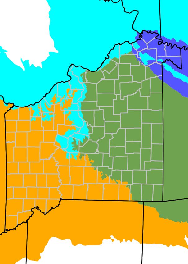
Erroneously Reported and Non-Native Species - County Records - Distributions

western Missouri along the Kansas border. However, the                      the Gulf and East Coasts. Isolated populations are also
sparsity of records from this region makes it difficult to                  found around numerous urban centers of the Midwest and
accurately define the species boundary. Until additional                    central plains (Powell et al. 2016). Two populations appear
material is available for evaluation, we have not included                  to be established in Missouri. Bufalino (2004) reported this
this species as part of the state herpetofauna.                             species from St. Louis County. A second population was
                                                                            discovered in Joplin, Missouri by Mr. A. Braun (Daniel et
                                                                            al. 2015).
Erroneously Reported and                                                         Briggler et al. (2015) reported the presence of a robust
Non-Native Species                                                          population of Italian Wall Lizard (Podarcis siculus) in a
                                                                            Joplin neighborhood after being contacted by a resident in
     Anderson (1945) reported two specimens of the Dwarf                    2013. This population apparently descended from a series
Salamander (Eurycea quadridigitata) from Roaring River                      of lizards imported from Topeka, KS, which escaped in
State Park in Barry County. With the nearest known                          2001. In many states, including Missouri, it is illegal to
naturally occurring populations of E. quadridigitata in                     release non-native species. Despite prohibitions, the
southern Arkansas, more than 125 miles from the Missouri                    majority of introduced populations of this species in North
border, it is likely that this record is based on misidentified,            America originated from released animals in the pet trade
but morphologically similar Oklahoma Salamanders (E.                        (Burke and Deichsel 2008).
tynerensis).                                                                     Thus far, non-native amphibians and reptiles in
     Johnson and Bader (1974) included Lesser Earless                       Missouri have been confined to urban centers and do not
Lizard (Holbrookia maculata) based on two specimens                         appear to constitute a threat to our native herpetofauna.
collected from Knob Noster State Park in Johnson County.                    However, this is not the case everywhere and non-native
Nickerson and Krager (1972) considered this record                          species that have become invasive are considered by many
problematic because of the close proximity of the park to                   biologists to be a major threat, second only to habitat loss
Whiteman Air Force Base and Central Missouri State                          or degradation, to native species. Responsible pet owners
University. The nearest record of this species is more than                 should always exercise care to prevent the spread of this
115 miles away in central Kansas. Further searches failed to                and all non-native species into the natural environment.
produce additional specimens. As a result, this species is
not considered to be part of Missouri's herpetofauna.
     Anderson (1957) listed the occurrence of the                           County Records
Queensnake (Regina septemvittata) in Missouri based on                          Earlier versions of this publication used Johnson
three specimens deposited in the American Museum of                         (2000) as an authority on herpetological county records.
Natural History collection. These specimens were ascribed                   However, Johnson's distribution maps are nearly two
to G.K. Noble and reported to come from Stone County. In                    decades out of date. Furthermore, a number of county
further investigation by Roger Conant (1960), Byron C.                      records reported by Johnson could not be subsequently
Marshall, who worked with Noble in the Interior Highlands                   verified with museum voucher specimens and are not
during this period, reportedly had no recollection of finding               recognized as valid for the purposes of this project.
this species. The nearest known populations of Queen                        Beginning with the 2012 version of the Atlas, we used only
Snake are in the Boston Mountains of Arkansas,                              vouchered specimens as the basis for reporting new
approximately 80 miles south of this locality. The questions                Missouri county records (except for the aforementioned
about the origin of the specimens and the absence of                        published records considered valid). Thus, all county
additional records from Missouri suggest that this species                  records mapped as "open circle" county records in some
does not occur in the state.                                                previous versions of the Atlas will not be considered valid
     One species of non-native frog and two species of                      and will therefore not be included on the county records
lizards have been reported in Missouri. A population of                     maps.
Greenhouse Frogs (Eleutherodactylus planirostris) was
established inside a commercial greenhouse in Jefferson
City, Missouri (J. Briggler, pers. comm.). The population of                Distributions
these small terrestrial breeding frogs persisted for several
years, but has apparently disappeared following renovation                       Distribution is one of many characteristics used to
of the greenhouse. There are no other reports of this                       describe a species and range maps (such as those found in
tropical species occurring within the state. Its apparent                   Conant and Collins (1998)) are used to approximate a
inability to survive extreme winter weather makes it                        species' likely distribution. This atlas uses locality dot
unlikely for these frogs to exist in Missouri as a                          maps, with each dot representing a known locality for that
free-ranging species outside of sheltered habitats, such as                 species. This conservative method results in an
greenhouses.                                                                underestimate of a species distribution but is more accurate
     Mediterranean Gecko (Hemidactylus turcicus) is native                  than a range map. The purpose of the atlas project is to
to the Mediterranean basin and western Asia. This species                   document as closely as possible both current and historical
is easily transported and a highly successful colonizer.                    distributions for all native amphibians and reptiles in
Populations of this species have been established                           Missouri.
worldwide. In the United States, this species is currently                       However, the printed version of the atlas only reflects
established widely throughout the south, especially along                   the best historical approximation of each species'

                                               Atlas of Missouri Amphibians and Reptiles for 2020                                           5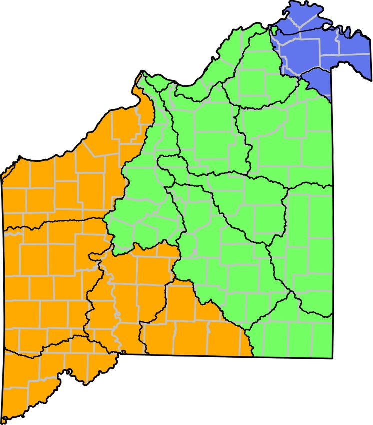
Terrestrial Ecoregions

distribution in the state. The most noticeable resulting                     In general, Level IV ecoregions are too granular to be
incongruity is that fact that some species are shown in                  useful in describing the distributions of Missouri
historical localities in which they are almost certainly no              amphibians and reptiles, several Ozark salamander species
longer found. For example, the Smooth Greensnake                         and many of the coastal plains species being notable
(Opheodrys vernalis) was once found in scattered                         exceptions. However, this level of detail is useful to
populations in the prairie regions of the state. Due to                  understand natural community distributions on which some
extensive habitat loss and possibly other reasons, they are              species are dependent. It also underscores the importance of
extremely rare or extirpated in the state.                               looking at border states and across artificial political
     While natural communities have long been a staple in                boundaries to understand distributions within Missouri.
ecology, formal classification of natural communities has                    Level I (page 8), Level II (page 9), Level III (page 10),
been undertaken relatively recently in Missouri (Nelson                  and Level IV (page 11) ecoregion maps for Missouri and
1987, 2005). Like individual species, natural communities                surrounding states, based on Omernik (1987) and Nigh and
can be described and characterized with distinct                         Schroeder (2002) are included here. The hierarchy for
distributions and abundances in different ecoregions (see                Levels I, II, and III is included in Table 1 (below), while the
next section). For example, glades are common in the                     Level III and Level IV hierarchy is included in Table 2
Ozarks but rare elsewhere in the state. Steyermark (1963),               (below). Unfortunately, the authors' coding scheme for
Yatskievych (1999), Pflieger (1989), Hawker (1992), and                  Level III is inconsistent, though the names do match. Both
Unklesbay and Vineyard (1992) all describe and summarize                 authors' codes for Level III are included in the tables as a
the complex interplay among geology, natural history,                    cross-reference. An earlier approach by Thom and Wilson
ecoregions, natural divisions, and natural communities                   (1980) divided Missouri into natural divisions and sections
from slightly different perspectives. Taken together, these              (page 7), roughly corresponding to Level III and Level IV
ideas form the basis of the biogeography of Missouri and                 ecoregions, respectively.
they are essential in understanding why plants and animals
have the distributions that we see today.                                Table 1. List of Level I, II, and III Terrestrial Ecoregions from
                                                                         Omernik (1987). Those regions marked with an asterisk (*) do not
Terrestrial Ecoregions                                                   occur in Missouri but are sufficiently close to be of interest to
                                                                         Missouri biologists. Level III codes from Nigh and Schroeder
     An ecoregion classification system attempts to define               (2002) are in parentheses.
and describe geographic regions that correspond to broad
                                                                          8. Eastern Temperate Forests
ecosystem patterns, topography, geology, soils, vegetation
                                                                               8.3. Southeastern USA Plains
patterns, and the distributions of plants and animals.
                                                                                      8.3.3. Interior Plateau* (71)
Omernik (1987) described ecoregions (Levels I, II, and III)
                                                                                      8.3.6. Mississippi Valley Loess Plains (74)
for the conterminous United States as a hierarchical scheme
                                                                                      8.3.2. Interior River Valleys and Hills (72)
with Level I corresponding to large regions and Level III
                                                                               8.4. Ozark / Ouachita / Appalachian Forests
representing smaller, more precisely described regions. The
                                                                                      8.4.5. Ozark Highlands (39)
Environmental Protection Agency (2003) is coordinating an
                                                                                      8.4.6. Boston Mountains* (38)
effort to further subdivide Level III regions into Level IV
                                                                               8.5. Southeast US Coastal Plain
regions. Nigh and Schroeder (2002) published Level III and
                                                                                      8.5.2. Mississippi Alluvial Plain (73)
Level IV ecoregions for Missouri.
     Some amphibian and reptile species follow defined                    9. Great Plains
ecoregions closely. For example, the Cave Salamander                          9.2. Temperate Prairies
(Eurycea lucifuga) is neatly confined to the Ozark                                    9.2.3. Western Corn Belt Plains (47)
Highlands (Level III) and found throughout the ecoregion,                             9.2.4. Central Irregular Plains (40)
with the exception of most of the Springfield Plateau (Level
IV). Several species found in the southeastern alluvial plain
                                                                         Table 2. List of Level III and Level IV Terrestrial Ecoregions
are particularly characteristic and also confined to that area
                                                                         from Nigh and Schroeder (2002). Those regions marked with an
(e.g., Three-toed Amphiuma (Amphiuma tridactylum) and
                                                                         asterisk (*) do not occur in Missouri but are sufficiently close to
Southern Watersnake (Nerodia fasciata)).
                                                                         be of interest to Missouri biologists. Those regions marked with a
     Many species, however, seem to be abundant
                                                                         caret (^) are contained entirely within the state's borders.
throughout Missouri, regardless of the region or natural
community. The American Bullfrog (Lithobates                              38. Boston Mountains* (8.4.6)
catesbeianus), Snapping Turtle (Chelydra serpentina), and                     38a. Upper Boston Mountains*
Western Ratsnake (Pantherophis obsoletus) among several                       38b. Lower Boston Mountains*
others fall into this category. Finally, many species are
more closely associated with a particular natural                         39. Ozark Highlands (8.4.5)
community or habitat than with a particular ecoregion or                      39a. Springfield Plateau
natural division. For example, The Flat-headed Snake                          39b. Elk River Hills
(Tantilla gracilis) can be found in the Ozark Highlands,                      39c. White River Hills
Osage Prairie, and Interior River Valleys and Hills but it is                 39d. Central Plateau
restricted to rocky glades.                                                   39e. Osage / Gasconade River Hills^
                                                                              39f. Saint Francois Knobs / Basins^
                                            Atlas of Missouri Amphibians and Reptiles for 2020                                                 6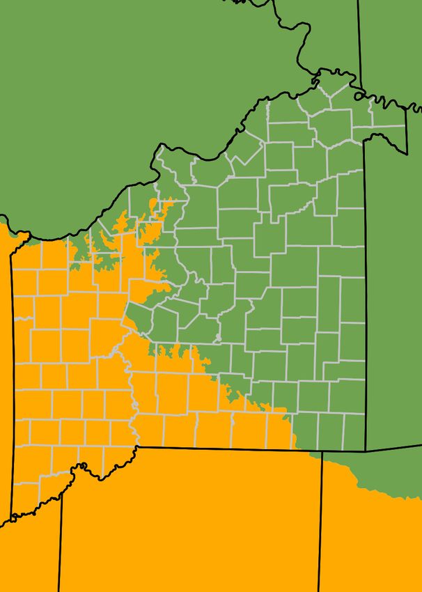
Aquatic Subregions

       39g.   Meramec River Hills^                                      Since many species of amphibians and reptiles are partially
       39h.   Current River Hills^                                      or wholly dependent on aquatic habitats, distributions can
       39i.   Easter Ozark Border^                                      sometimes be best understood and explained by examining
       39j.   Black River Hills Border^                                 aquatic subregions, ecological drainage units, and even
       39k.   Prairie Ozark Border^                                     individual watersheds.
                                                                             The base map for major rivers and streams (page 12)
40. Central Irregular Plains (9.2.4)                                    shows locations of actual rivers and streams inside
    40a. Loess Flats and Till Plains                                    Missouri and just outside the state's borders where
    40b. Osage Cuestas*                                                 appropriate (USGS 1994; MDC 2007b). The watershed
    40c. Wooded Osage Plains                                            boundaries map (page 13) displays the maximum terrestrial
    40d. Cherokee Plains                                                boundary for major watersheds (NRCS 2002). Both of
    40e. Claypan Prairie^                                               these maps are underlain with unique background colors to
47. Western Corn Belt Plains (9.2.3)                                    display Missouri's primary drainage systems: a) Mississippi
    47d. Missouri Alluvial Plain                                        River, b) Missouri River, c) Arkansas River, and d) White
    47e. Steeply Rolling Loess Prairies                                 River.
    47f. Rolling Loess Prairies                                              Some species found in the state exhibit distributions
    47h. Nebraska / Kansas Loess Hills*                                 that can be better understood by referring to these primary
    47i. Loess and Glacial Drift Hills*                                 drainage systems. The ecological drainage units map (page
    47m. Western Loess Hills                                            14) shows a somewhat consolidated view of the watersheds
                                                                        map based on those watersheds and other characteristics. It
71. Interior Plateau* (8.3.3)                                           is underlain with unique background colors showing the
     71m. Northern Shawnee Hills*                                       three broad aquatic subregions in the state. Still more
     71n. Southern Shawnee Hills*                                       detailed aquatic region classifications are available but
                                                                        often include areas based on very small creeks and their
72. Interior River Valleys and Hills (8.3.2)                            watersheds and are therefore not included here.
     72a. Wabash / Ohio Bottomlands*
     72d. Upper Mississippi Alluvial Plain                              Table 3. List of Aquatic Subregions and Ecological Drainage
     72e. Middle Mississippi Alluvial Plain                             Units from MSDIS (2009a, 2009c). Each drainage unit is
     72f. River Hills                                                   indicated with its primary drainage system: a) Mississippi River,
     72g. Southern Ozarkian River Bluffs*                               b) Missouri River, c) Arkansas River, d) White River.
     72i. Western Dissected Illinoian Till Plain*
     72j. Southern Illinoian Till Plain*                                 * Central Plains Subregion
     72k. Cretaceous Hills*                                                   * Blackwater / Lamine (b)
     72l. Karstic Northern Ozarkian River Bluffs*                             * Cuivre / Salt (a)
                                                                              * Des Moines (a)
73. Mississippi Alluvial Plain (8.5.2)                                        * Grand / Chariton (b)
    73a. Northern Holocene Meander Belts                                      * Kansas (b)
    73b. Northern Pleistocene Valley Trains*                                  * Nishnabotna / Platte (b)
    73c. Saint Francis Lowlands                                               * Osage / South Grand (b)
    73f. Western Lowlands Holocene Meander Belts
    73g. Western Lowlands Pleistocene Valley Trains                      * Ozarks Subregion
                                                                              * Apple / Joachim (a)
74. Valley Loess Plains (8.3.6)                                               * Black / Current (d)
    74a. Bluff Hills                                                          * Gasconade (b)
    74b. Loess Plains                                                         * Meramec (a)
                                                                              * Moreau / Loutre (b)
Aquatic Subregions                                                            * Osage (b)
                                                                              * Neosho (c)
     Like terrestrial ecoregions, aquatic subregions can be                   * Upper Saint Francis / Castor (a)
classified in discrete units, based on watershed and                          * White (d)
hydrological characteristics. Subregions are composed of
ecological drainage units, which are major watersheds that               * Mississippi Alluvial Subregion
are consolidated based on similarity and proximity (MSDIS                     * Black / Cache (a)
2009a). Subregions and their component drainage units can                     * Saint Francis / Little (a)
be seen in Table 3 (below).                                                   * Saint Johns Bayou (a)
     Naturally, many of the same patterns emerge in both
terrestrial and aquatic geographic classifications since the
two are not independent of one another. However, aquatic
subregions and ecological drainage units can differ from
their terrestrial counterparts since most aquatic organisms
are confined to watersheds as well as specific habitats.

                                           Atlas of Missouri Amphibians and Reptiles for 2020                                               7
Natural Divisions and Sections
Western Modified from Thom and Wilson (1980)
Glaciated Base map data provided by MSDIS (2009b) and MDC (2007a)
Grand River
Mis
Plains Glaciated Plains Eastern
sou
Glaciated Plains
ri (
Glaciated Ozark Border
Up
Plains Up
pe Ozark Plateau
per
rM
iss Osage Plains
and
L i
iss
L
ip Mississippi Lowlands
nc
ol
pi
ow
Big Rivers
n
er)
Hi
lls
Missouri
Ozark
Border
Osage Missi-
Plains ssippi Lo
we
Ozark rM
Border iss
iss
ip
p
Natural Divisions and Sections Map
Upper Ozarks i
Saint
Atlas of Missouri Amphibians and Reptiles for 2020
Francois
Springfield Mtns
Plateau Crowley's
Ridge
Lower Ozarks Missi-
ssippi
Elk White River Lowlands
River
8Level I Terrestrial Ecoregions
Data provided by EPA (2003)
Base map data provided by the National Atlas (2001)
Eastern
Temperate Forests
Great
Plains
Level I Terrestrial Ecoregions Map
Atlas of Missouri Amphibians and Reptiles for 2020
9Temperate Prairies Level II Terrestrial Ecoregions
Data provided by EPA (2003)
Base map data provided by the National Atlas (2001)
Southeastern
USA Plains
Temperate
Prairies
Level II Terrestrial Ecoregions Map
Atlas of Missouri Amphibians and Reptiles for 2020
Ozark / Ouachita /
Appalachian Forests Southeast
US Coastal Plain
10Central Irregular Plains Level III Terrestrial Ecoregions
Western Data provided by EPA (2003)
Corn Belt Base map data provided by the National Atlas (2001)
Plains
Interior River
Valleys and Hills
Central
Irregular
Plains
Level III Terrestrial Ecoregions Map
Interior
Atlas of Missouri Amphibians and Reptiles for 2020
Plateau
Mississippi Valley
Ozark Highlands Loess Plains
Mississippi (Crowley's Ridge)
Boston Mtns Alluvial Plain
11Western Level IV Terrestrial Ecoregions
Loess Hills
Rolling Data provided by EPA (2003)
Steeply Rolling Loess Base map data provided by the National Atlas (2001)
Loess Prairies Prairies
Loess Flats and Till Plains Upper Mississippi
Alluvial Plain
Western Dissected
Illinoian Till Plain
Nebraska / Kansas
Loess Hills
Loess / Glacial
Drift Hills River Hills
Southern Illinoian
Claypan Till Plain
Prairie
Rolling Loess
Missouri Prairies
Wabash / Ohio
Alluvial Bottomlands
Plain
Wooded Osage Plains Middle Mississippi
Prairie Alluvial Plain
Ozark
Border
Eastern
Ozark
Osage / Gasconade Border
Osage
Cuestas River Hills
Meramec
River Hills Northern (Karstic)
Ozarkian River Bluffs
Cherokee Southern
Level IV Terrestrial Ecoregions Map
Plains
Saint Northern
Atlas of Missouri Amphibians and Reptiles for 2020
Francois Shawnee Hills
Knobs / Southern
Current Basins
Springfield River
Plateau Hills
Black
River
Hills Bluff Cretaceous
Border Hills Hills
White River Hills Saint Loess
Francis Plains
Lowlands
Elk River
Hills Central Plateau Northern Holocene
Meander Belts
Western Lowlands
Pleistocene Valley Trains
Lower Upper Western Lowlands Northern Pleistocene
Boston Mountains Holocene Meander Belts Valley Trains
12Mi
G
d
r
One
a
Mo De
in s
dle
Sho
b otna R
E Fk
es Fo
W Fk
Nishna
E Fk
x R
Fk
N
nd R
R
R
al C
Fk
Cr
r
Rivers and Major Streams
io
Cr W
gh
rk
Bl
M
tts a ya
Hi
ck Data provided by USGS (1994) and MDC (2007b)
Ta
Lo SF
So
b k
is
co
Weldon R
ut
s
ird nd
h
Base map data provided by MSDIS (2009b)
eR
Cr a
Hundred And Two R
No
R
Th
ou
Nodaway R
Cr
Fa Mi
r
Chariton R
rth
ri
dd
Platt
om
Mi
C
Gr bi
p
le F
Fa
an us
b
d R ab
so
ss
Big
iu
iu
Ri
R s
Squaw
is
Mississippi River Watershed
nR
sR
Gr R
W Fk
e
s
ve
an
n
r
d
o
Cr
ip
R Missouri River Watershed
st
N
E Fk
pi
Fk
ind
Medicine Cr
Mussel Fk
lf R th R White River Watershed
Gr
Shoal Cr
R
Locust Cr
Wo Nor
Fk
Ot
te
iv
Arkansas River Watershed
Mi
Cr rC
lt R
e
dd
w r
B
Sa
r
eR
lo
le
eR
l
Cr
tle
tle
r
tt
Ye Fk
Middle
E Fk
oo
r
ig C
Lit
ce
r
Lit
F
Pla
yC
ke
Platt
Waken Elk Fk en
ish
nR Sp Cr Ba
Str
da Cr
h Fk
dR
in
arito
g
Long No
Ch
R
Missou Branch
Cr
Missou rth
ange
ri R
Sout
ri R W Fk
r es
t
me
r Cr
rC Salt Fk
nite
Fk Cu
a
m
Cr au
Cr
eR
Lo
-B ivr
R
Bo
Perche Cr
Mo
u
Fe nne
R
lu
-A eR
sas ni Cr
Big Cr
tre
S
leB
Kan Davis rR
R
Blue
t
wate Peruqu
Cr
Cedar
Mid
Wakarusa R Petite e Cr
Lit
Black R
Saline Cr
Cr t
k
dy ri
Bi
dle
Los
Auxvasse
g
Mud ou
R
ne ss
Cr
Cr Moniteau Cr
R Dardren Mi
C
Os
uri
Clear F
Cr
k
dle sso
Mid Flat
age
Te
Mi
R
South
NF
R
d
R
bo
r
Cr eau
de
Cr Mor
R
Grand R
Ma es C
na
S Fk R
ec
e
o
m
sR
ag
hi
ar Cr
ais ygn
am
Big Sug Os
asc
Deep-
ac
er
eR
es
s
G
Jo
M
R
water Cr
k
eu
Cr
b
Marie
lF
ur
Little Osage R e Bo a
er
Osage R Littl
ys R
in
Co
M
u
n-
Tavern Cr
R
ea
bl
aR
Mar
r
rto
Niaa
g
e
gu i
Rivers and Major Streams Map
Marmaton R
Bi
Lin
Cr
rC
sC
R
r
W au C
Litt
ea
dle
u- r
Pin
Cr
le
Cl
Be
Fk
Niangu
ey
yC
se
Po
ar
Mi
r
Fk
C Apple Cr
or
m
r
s
e
H
Big
Huzzah
r Cr
Dry
Cr
m
Cr
ag
Atlas of Missouri Amphibians and Reptiles for 2020
si
Dry Wood
Little St F R
West
ed
k
Lit
Os
Fk
Pine
tle
ss
Ceda
wat
eT
Sa
th F
e-
Co
Cro
er
yR
Big Cr
ip
cR o
w
re
ke
Roubidoux Cr
Whit er R
d
Nor
pi
Cr
Tur
R
Cr
Sa Logan
R
nba
Sprin cR
C
gR Fk Cr r -sion
Ri
es
Bea r
Castor R
ck
Bl
Jam ks ve Channel
ver
y Cr Jac Di
ac
ve
Cr
k
Cen Finle
r
ter
R
Sh Cr
r
oa
Sain
Br
Cur
Cr
lC
nC
r
Whitew
ya
re
Ne Fla
t Fr
n
wa
os tC
S
Cr
r
Bull
tC
r
nt R
ho r
anc
Can
R
Castor R
ve
e
ater R
S
a
Elk
R
is R
hite) R
Be
Cr
Elev
Bi uga
My
g r
es
e
k
R
Li
Dry C
r
h
att
Cr
te
itc
B ttl
rk (W
hi
S
R lac e
n Po
Cr
W
rD
White
Spring R
R
Lit uga
e
tle r
int R
Cr
Riv
O Crooked Cr South
Northfo
Long Cr
Fk
Kings R
tle
sa
ge
Lit
W Cr
Ea ar
Cr gle
13One Hundred and Two
Keg- Lower Watershed Boundaries
Nod- Upper Des Moines
Weeping away
Water Tarkio- North Data provided by NRCS (2002)
Wolf Fabius Base map data provided by MSDIS (2009b)
Thompson
Bear-
Nishnabotna Chari- South Wyaconda
Upper ton Fabius
Mississippi River Watershed
Grand Lower
Grand Missouri River Watershed
Independence-
North White River Watershed
Fork
Sugar Platte Arkansas River Watershed
Salt
Lower Salt The Sny
Lower Little Peruque-Piasa
South Fork
Missouri-
Salt
Crooked
Lower Lower
Kansas Missouri- Cuivre
Moreau
Blackwater
Lamine
Lower Cahokia-Joachim
Missouri
South
Grand Lower
Lake of the
Lower Marais Ozarks Lower Bourbeuse
Des Cygnes Osage
Harry S Truman
Little Osage
Niangua Big Upper Mississippi-
Watershed Boundaries Map
Meramec
Cape Girardeau
Marmaton
Pomme
Sac
de
Atlas of Missouri Amphibians and Reptiles for 2020
Terre Upper
Gasconade Big
Upper Saint
Piney New Madrid-
Black Francis White-
water Saint Johns
Upper
Current
Spring
James
Northfork
Eleven Lower Mississippi-
Point Little Memphis
Elk River
Lake O' The
Cherokees Ditches
Spring
Bull Shoals
Beaver
Cache Lower Saint Francis
Lower Black
14Des Moines Ecological Drainage Units
Nishnabotna / Platte Data provided by MSDIS (2009c)
Base map data provided by MSDIS (2009b)
Cuivre / Salt
Grand / Chariton
Central Plains Subregion
Ozarks Subregion
Mississippi Alluvial Subregion
Blackwater / Lamine
Kansas
Moreau / Loutre
Apple / Joachim
Osage / South Grand
Meramec
Ecological Drainage Units Map
Upper Saint Francis /
Atlas of Missouri Amphibians and Reptiles for 2020
Osage Gasconade Castor
Neosho Saint Francis
/ Little
White Black / Current
Saint Johns Bayou
Black / Cache
15Iowa
County and Surrounding States Map
Atchison Worth Mercer Putnam Scot-
Nodaway Schuy- land Clark Base map data provided by MSDIS (2009b)
Harrison ler
Gentry Sullivan Adair
Nebraska
Holt Grundy Knox Lewis
Andrew
DeKalb Daviess
Linn Macon Shelby Marion
Living-
ston
Buch- Clinton Caldwell
anan Chariton Ralls
Platte Carroll Ran- Monroe
dolph
Clay Ray Pike
Howard Audrain
Saline Lincoln
Lafayette Boone Mont-
Jackson gomery
Cooper Callaway Saint
Johnson Pettis Warren Charles Saint
Cass Louis
Moni- Gas-
teau Cole co-
Morgan Osage nade Franklin
Illinois
Kansas Henry Jeffer-
Bates Benton son
Miller
Maries
Saint Camden Crawford Washing-
Clair Hickory ton Sainte
Phelps Gene-
Vernon vieve
County and Surrounding States Map
Pulaski Saint
Cedar Francois Perry
Dallas Iron
Polk Laclede Dent
Atlas of Missouri Amphibians and Reptiles for 2020
Barton Reynolds Madison Cape
Dade Girar-
deau
Webster Wright Texas Boll-
Greene
Jasper inger
Shannon Wayne
Lawrence Scott
Christian Douglas Carter Missi-
Newton Stoddard ssippi Kentucky
Stone Howell Butler
Barry Oregon Ripley
McDonald Taney Ozark New
Oklahoma Madrid
Arkansas Pemi-
Tennessee
Dunk- scot
lin
16Species Locality Maps
Species Locality Maps
Key:
• Museum or published record believed to be valid
* County record only for:
-- Valid record without a specific locality
-- Species of conservation concern, locality withheld
? Questionable record that may be valid
Siren intermedia
Western Lesser Siren
Cryptobranchus alleganiensis Ambystoma annulatum
Hellbender Ringed Salamander
Atlas of Missouri Amphibians and Reptiles for 2020 17Species Locality Maps
Ambystoma maculatum Ambystoma opacum
Spotted Salamander Marbled Salamander
Ambystoma talpoideum Ambystoma texanum
Mole Salamander Small-mouthed Salamander
Atlas of Missouri Amphibians and Reptiles for 2020 18Species Locality Maps
Ambystoma tigrinum Notophthalmus viridescens
Eastern Tiger Salamander Central Newt
Necturus maculosus Amphiuma tridactylum
Mudpuppy Three-toed Amphiuma
Atlas of Missouri Amphibians and Reptiles for 2020 19Species Locality Maps
Eurycea longicauda Eurycea lucifuga
Long-tailed Salamander Cave Salamander
Eurycea spelaea Eurycea tynerensis
Grotto Salamander Oklahoma Salamander
Atlas of Missouri Amphibians and Reptiles for 2020 20Species Locality Maps
Hemidactylium scutatum Plethodon albagula
Four-toed Salamander Western Slimy Salamander
Plethodon angusticlavius Plethodon serratus
Ozark Zigzag Salamander Southern Red-backed Salamander
Atlas of Missouri Amphibians and Reptiles for 2020 21Species Locality Maps
Scaphiopus holbrookii Spea bombifrons
Eastern Spadefoot Plains Spadefoot
Anaxyrus americanus Anaxyrus cognatus
American Toad Great Plains Toad
Atlas of Missouri Amphibians and Reptiles for 2020 22Species Locality Maps
Anaxyrus fowleri Anaxyrus woodhousii
Fowler's Toad Woodhouse's Toad
Acris blanchardi Hyla chrysoscelis
Blanchard's Cricket Frog Cope's Gray Treefrog
Atlas of Missouri Amphibians and Reptiles for 2020 23Species Locality Maps
Hyla cinerea Hyla versicolor
Green Treefrog Gray Treefrog
Pseudacris crucifer Pseudacris feriarum
Spring Peeper Upland Chorus Frog
Atlas of Missouri Amphibians and Reptiles for 2020 24Species Locality Maps
Pseudacris fouquettei Pseudacris illinoensis
Cajun Chorus Frog Illinois Chorus Frog
Pseudacris maculata Lithobates areolatus
Boreal Chorus Frog Northern Crawfish Frog
Atlas of Missouri Amphibians and Reptiles for 2020 25Species Locality Maps
Lithobates blairi Lithobates catesbeianus
Plains Leopard Frog American Bullfrog
Lithobates clamitans Lithobates palustris
Green Frog Pickerel Frog
Atlas of Missouri Amphibians and Reptiles for 2020 26Species Locality Maps
Lithobates pipiens Lithobates sphenocephalus
Northern Leopard Frog Southern Leopard Frog
Lithobates sylvaticus Gastrophryne carolinensis
Wood Frog Eastern Narrow-mouthed Toad
Atlas of Missouri Amphibians and Reptiles for 2020 27Species Locality Maps
Gastrophryne olivacea Crotaphytus collaris
Western Narrow-mouthed Toad Eastern Collared Lizard
Phrynosoma cornutum Sceloporus consobrinus
Texas Horned Lizard Prairie Lizard
Atlas of Missouri Amphibians and Reptiles for 2020 28Species Locality Maps
Aspidoscelis sexlineata Plestiodon anthracinus
Six-lined Racerunner Southern Coal Skink
Plestiodon fasciatus Plestiodon laticeps
Common Five-lined Skink Broad-headed Skink
Atlas of Missouri Amphibians and Reptiles for 2020 29Species Locality Maps
Plestiodon obsoletus Plestiodon septentrionalis
Great Plains Skink Prairie Skink
Scincella lateralis Ophisaurus attenuatus
Little Brown Skink Western Slender Glass Lizard
Atlas of Missouri Amphibians and Reptiles for 2020 30Species Locality Maps
Hemidactylus turcicus Podarcis siculus
Mediterranean Gecko Italian Wall Lizard
Cemophora coccinea Coluber constrictor
Northern Scarletsnake North American Racer
Atlas of Missouri Amphibians and Reptiles for 2020 31Species Locality Maps
Coluber flagellum Lampropeltis calligaster
Eastern Coachwhip Prairie Kingsnake
Lampropeltis holbrooki Lampropeltis nigra
Speckled Kingsnake Eastern Black Kingsnake
Atlas of Missouri Amphibians and Reptiles for 2020 32Species Locality Maps
Lampropeltis triangulum Opheodrys aestivus
Eastern Milksnake Northern Rough Greensnake
Opheodrys vernalis Pantherophis emoryi
Smooth Greensnake Great Plains Ratsnake
Atlas of Missouri Amphibians and Reptiles for 2020 33Species Locality Maps
Pantherophis obsoletus Pantherophis ramspotti
Western Ratsnake Western Foxsnake
Pantherophis vulpinus Pituophis catenifer
Eastern Foxsnake Bullsnake
Atlas of Missouri Amphibians and Reptiles for 2020 34Species Locality Maps
Sonora semiannulata Tantilla gracilis
Variable Groundsnake Flat-headed Snake
Carphophis vermis Diadophis punctatus
Western Wormsnake Ring-necked Snake
Atlas of Missouri Amphibians and Reptiles for 2020 35Species Locality Maps
Farancia abacura Heterodon gloydi
Western Mudsnake Dusty Hog-nosed Snake
Heterodon nasicus Heterodon platirhinos
Plains Hog-nosed Snake Eastern Hog-nosed Snake
Atlas of Missouri Amphibians and Reptiles for 2020 36Species Locality Maps
Clonophis kirtlandii Haldea striatula
Kirtland's Snake Rough Earthsnake
Nerodia cyclopion Nerodia erythrogaster
Mississippi Green Watersnake Plain-bellied Watersnake
Atlas of Missouri Amphibians and Reptiles for 2020 37Species Locality Maps
Nerodia fasciata Nerodia rhombifer
Broad-banded Watersnake Diamond-backed Watersnake
Nerodia sipedon Regina grahamii
Common Watersnake Graham's Crawfish Snake
Atlas of Missouri Amphibians and Reptiles for 2020 38Species Locality Maps
Storeria dekayi Storeria occipitomaculata
DeKay's Brownsnake Northern Red-bellied Snake
Thamnophis proximus Thamnophis radix
Orange-striped Ribbonsnake Plains Gartersnake
Atlas of Missouri Amphibians and Reptiles for 2020 39Species Locality Maps
Thamnophis sirtalis Tropidoclonion lineatum
Common Gartersnake Lined Snake
Virginia valeriae Agkistrodon contortrix
Western Smooth Earthsnake Copperhead
Atlas of Missouri Amphibians and Reptiles for 2020 40Species Locality Maps
Agkistrodon piscivorus Crotalus horridus
Western Cottonmouth Timber Rattlesnake
Sistrurus catenatus Sistrurus miliarius
Eastern Massasauga Western Pygmy Rattlesnake
Atlas of Missouri Amphibians and Reptiles for 2020 41Species Locality Maps
Sistrurus tergeminus Chelydra serpentina
Prairie Massasauga Snapping Turtle
Macrochelys temminckii Kinosternon flavescens
Alligator Snapping Turtle Yellow Mud Turtle
Atlas of Missouri Amphibians and Reptiles for 2020 42Species Locality Maps
Kinosternon subrubrum Sternotherus odoratus
Mississippi Mud Turtle Eastern Musk Turtle
Chrysemys dorsalis Chrysemys picta
Southern Painted Turtle Western Painted Turtle
Atlas of Missouri Amphibians and Reptiles for 2020 43Species Locality Maps
Deirochelys reticularia Emydoidea blandingii
Western Chicken Turtle Blanding's Turtle
Graptemys geographica Graptemys ouachitensis
Northern Map Turtle Ouachita Map Turtle
Atlas of Missouri Amphibians and Reptiles for 2020 44Species Locality Maps
Graptemys pseudogeographica Pseudemys concinna
False Map Turtle River Cooter
Terrapene carolina Terrapene ornata
Three-toed Box Turtle Ornate Box Turtle
Atlas of Missouri Amphibians and Reptiles for 2020 45Species Locality Maps
Trachemys scripta Apalone mutica
Red-eared Slider Midland Smooth Softshell
Apalone spinifera
Eastern Spiny Softshell
Atlas of Missouri Amphibians and Reptiles for 2020 46County Records Maps
County Records Maps
Key:
• Valid vouchered county record
Siren intermedia
Western Lesser Siren
Cryptobranchus alleganiensis Ambystoma annulatum
Hellbender Ringed Salamander
Atlas of Missouri Amphibians and Reptiles for 2020 47County Records Maps
Ambystoma maculatum Ambystoma opacum
Spotted Salamander Marbled Salamander
Ambystoma talpoideum Ambystoma texanum
Mole Salamander Small-mouthed Salamander
Atlas of Missouri Amphibians and Reptiles for 2020 48County Records Maps
Ambystoma tigrinum Notophthalmus viridescens
Eastern Tiger Salamander Central Newt
Necturus maculosus Amphiuma tridactylum
Mudpuppy Three-toed Amphiuma
Atlas of Missouri Amphibians and Reptiles for 2020 49County Records Maps
Eurycea longicauda Eurycea lucifuga
Long-tailed Salamander Cave Salamander
Eurycea spelaea Eurycea tynerensis
Grotto Salamander Oklahoma Salamander
Atlas of Missouri Amphibians and Reptiles for 2020 50County Records Maps
Hemidactylium scutatum Plethodon albagula
Four-toed Salamander Western Slimy Salamander
Plethodon angusticlavius Plethodon serratus
Ozark Zigzag Salamander Southern Red-backed Salamander
Atlas of Missouri Amphibians and Reptiles for 2020 51County Records Maps
Scaphiopus holbrookii Spea bombifrons
Eastern Spadefoot Plains Spadefoot
Anaxyrus americanus Anaxyrus cognatus
American Toad Great Plains Toad
Atlas of Missouri Amphibians and Reptiles for 2020 52County Records Maps
Anaxyrus fowleri Anaxyrus woodhousii
Fowler's Toad Woodhouse's Toad
Acris blanchardi Hyla chrysoscelis
Blanchard's Cricket Frog Cope's Gray Treefrog
Atlas of Missouri Amphibians and Reptiles for 2020 53County Records Maps
Hyla cinerea Hyla versicolor
Green Treefrog Gray Treefrog
Pseudacris crucifer Pseudacris feriarum
Spring Peeper Upland Chorus Frog
Atlas of Missouri Amphibians and Reptiles for 2020 54County Records Maps
Pseudacris fouquettei Pseudacris illinoensis
Cajun Chorus Frog Illinois Chorus Frog
Pseudacris maculata Lithobates areolatus
Boreal Chorus Frog Northern Crawfish Frog
Atlas of Missouri Amphibians and Reptiles for 2020 55County Records Maps
Lithobates blairi Lithobates catesbeianus
Plains Leopard Frog American Bullfrog
Lithobates clamitans Lithobates palustris
Green Frog Pickerel Frog
Atlas of Missouri Amphibians and Reptiles for 2020 56County Records Maps
Lithobates pipiens Lithobates sphenocephalus
Northern Leopard Frog Southern Leopard Frog
Lithobates sylvaticus Gastrophryne carolinensis
Wood Frog Eastern Narrow-mouthed Toad
Atlas of Missouri Amphibians and Reptiles for 2020 57County Records Maps
Gastrophryne olivacea Crotaphytus collaris
Western Narrow-mouthed Toad Eastern Collared Lizard
Phrynosoma cornutum Sceloporus consobrinus
Texas Horned Lizard Prairie Lizard
Atlas of Missouri Amphibians and Reptiles for 2020 58County Records Maps
Aspidoscelis sexlineata Plestiodon anthracinus
Six-lined Racerunner Southern Coal Skink
Plestiodon fasciatus Plestiodon laticeps
Common Five-lined Skink Broad-headed Skink
Atlas of Missouri Amphibians and Reptiles for 2020 59County Records Maps
Plestiodon obsoletus Plestiodon septentrionalis
Great Plains Skink Prairie Skink
Scincella lateralis Ophisaurus attenuatus
Little Brown Skink Western Slender Glass Lizard
Atlas of Missouri Amphibians and Reptiles for 2020 60County Records Maps
Hemidactylus turcicus Podarcis siculus
Mediterranean Gecko Italian Wall Lizard
Cemophora coccinea Coluber constrictor
Northern Scarletsnake North American Racer
Atlas of Missouri Amphibians and Reptiles for 2020 61County Records Maps
Coluber flagellum Lampropeltis calligaster
Eastern Coachwhip Prairie Kingsnake
Lampropeltis holbrooki Lampropeltis nigra
Speckled Kingsnake Eastern Black Kingsnake
Atlas of Missouri Amphibians and Reptiles for 2020 62County Records Maps
Lampropeltis triangulum Opheodrys aestivus
Eastern Milksnake Northern Rough Greensnake
Opheodrys vernalis Pantherophis emoryi
Smooth Greensnake Great Plains Ratsnake
Atlas of Missouri Amphibians and Reptiles for 2020 63County Records Maps
Pantherophis obsoletus Pantherophis ramspotti
Western Ratsnake Western Foxsnake
Pantherophis vulpinus Pituophis catenifer
Eastern Foxsnake Bullsnake
Atlas of Missouri Amphibians and Reptiles for 2020 64County Records Maps
Sonora semiannulata Tantilla gracilis
Variable Groundsnake Flat-headed Snake
Carphophis vermis Diadophis punctatus
Western Wormsnake Ring-necked Snake
Atlas of Missouri Amphibians and Reptiles for 2020 65County Records Maps
Farancia abacura Heterodon gloydi
Western Mudsnake Dusty Hog-nosed Snake
Heterodon nasicus Heterodon platirhinos
Plains Hog-nosed Snake Eastern Hog-nosed Snake
Atlas of Missouri Amphibians and Reptiles for 2020 66County Records Maps
Clonophis kirtlandii Haldea striatula
Kirtland's Snake Rough Earthsnake
Nerodia cyclopion Nerodia erythrogaster
Mississippi Green Watersnake Plain-bellied Watersnake
Atlas of Missouri Amphibians and Reptiles for 2020 67County Records Maps
Nerodia fasciata Nerodia rhombifer
Broad-banded Watersnake Diamond-backed Watersnake
Nerodia sipedon Regina grahamii
Common Watersnake Graham's Crawfish Snake
Atlas of Missouri Amphibians and Reptiles for 2020 68County Records Maps
Storeria dekayi Storeria occipitomaculata
DeKay's Brownsnake Northern Red-bellied Snake
Thamnophis proximus Thamnophis radix
Orange-striped Ribbonsnake Plains Gartersnake
Atlas of Missouri Amphibians and Reptiles for 2020 69County Records Maps
Thamnophis sirtalis Tropidoclonion lineatum
Common Gartersnake Lined Snake
Virginia valeriae Agkistrodon contortrix
Western Smooth Earthsnake Copperhead
Atlas of Missouri Amphibians and Reptiles for 2020 70County Records Maps
Agkistrodon piscivorus Crotalus horridus
Western Cottonmouth Timber Rattlesnake
Sistrurus catenatus Sistrurus miliarius
Eastern Massasauga Western Pygmy Rattlesnake
Atlas of Missouri Amphibians and Reptiles for 2020 71County Records Maps
Sistrurus tergeminus Chelydra serpentina
Prairie Massasauga Snapping Turtle
Macrochelys temminckii Kinosternon flavescens
Alligator Snapping Turtle Yellow Mud Turtle
Atlas of Missouri Amphibians and Reptiles for 2020 72County Records Maps
Kinosternon subrubrum Sternotherus odoratus
Mississippi Mud Turtle Eastern Musk Turtle
Chrysemys dorsalis Chrysemys picta
Southern Painted Turtle Western Painted Turtle
Atlas of Missouri Amphibians and Reptiles for 2020 73County Records Maps
Deirochelys reticularia Emydoidea blandingii
Western Chicken Turtle Blanding's Turtle
Graptemys geographica Graptemys ouachitensis
Northern Map Turtle Ouachita Map Turtle
Atlas of Missouri Amphibians and Reptiles for 2020 74County Records Maps
Graptemys pseudogeographica Pseudemys concinna
False Map Turtle River Cooter
Terrapene carolina Terrapene ornata
Three-toed Box Turtle Ornate Box Turtle
Atlas of Missouri Amphibians and Reptiles for 2020 75County Records Maps
Trachemys scripta Apalone mutica
Red-eared Slider Midland Smooth Softshell
Apalone spinifera
Eastern Spiny Softshell
Atlas of Missouri Amphibians and Reptiles for 2020 76Acknowledgements - Literature Cited
Gremaud, Adam Guerich, Brad Hadley, Adam Hamlin, D.
Acknowledgements Harrison, Kevin Hedgpeth, A.J. Hendershott, Robert
Data for the base county maps for the locality and Henderson, Mary Hennen, John Hess, Joshua Hill, Dan
county distributions, the labeled county map, and the Hocking, Colby Hodges, Dana Hoisington, Ethan
ecological drainage units and aquatic subregions were Hollender, Terry Holtsclaw, E. Hooper, Emily Horner, Ann
generously provided by the Missouri Spatial Data Horsman, Brian Hubbs, Jamie Hubert, James Hunt, Seth
Information Service (MSDIS 2009a, 2009b, 2009c). Data Ince, Adam Ivey, Thomas Jay, Matt Jeppson, Tom Jessen,
for the major rivers were provided by the United States Tom Johnson, Mike Jones, Jim Lamer, John Karel, Tim
Geological Survey (USGS 1994) and supplemented with Kavan, Kate Kelly, Bob Kipfer, Arnold Kluge, Bob Krager,
data from the Missouri Department of Conservation (MDC K. Korthas, Mike Leahy, Kevin Lewis, S. Liebi, Day
2007). Data for Missouri natural divisions and sections Ligon, Elicia Ligon, Kenton Lohraff, Alexandria London,
(based on Thom and Wilson (1980)) were generously Peter Lowther, Amy McClure, Roy McDiarmid, Elizabeth
provided by the Missouri Department of Conservation McGhee, B. McKeage, Paul McKenzie, Don McKnight,
(MDC 2007). Data for watershed boundaries were provided Jennifer Maag, Glenn Manning, Nicholas March, Dexter
by the Natural Resources Conservation Service (NRCS Mardis, Frank Martinez, Rebecca Maxfield, Christine
2002). Data for ecoregions were provided by the US Mayer, Arianne Messerman, Dean Metter, Brian Miller,
Environmental Protection Agency (EPA 2003). Base map Danielle Miller, J. Miller, N. Mitchell, Chad Montgomery,
data for surrounding states were provided by the National D. Moore, T. Moore, Denise Morgan-Irish, Sarah Moss,
Atlas of the United States (National Atlas 2001). Nathan Muenks, Tom Nagel, Kevin Narum, L.
All technology-related aspects of the Missouri Neuman-Lee, Chris Newbold, Abby Nicholson, Laurel
Herpetological Atlas Project are supported by a suite of Norton, Jim Oehmke, Tyler Olcott, Matt Ormsby, Seth
open source software that is both gratis (free as in beer) and Otto, Cheryl Palmer, Peter Paplanus, John Par, Caleb
libre (free as in speech). Kubuntu Linux is used as the Pemberton, Bill Peterman, Katie Petrie, Tim Pettinelli,
operating system to host and execute all processes related Chris Phillips, Nick Pieroni, G. Pinson, G. Pitchford, P.
to the project. Atlas, checklist, and GIS data are stored in a Pitts, J. Pollock, Crystal Poole, Robert Powell, Tracey
PostgreSQL database, which has been spatially enabled Prenger, B. Probst, Keith Pulles, Holly Quinn, Hugh Quinn,
using PostGIS. Project documentation and database scripts Corey Raimond, Alan Resetar, Joe Ridings, Daren Riedle,
are written with PHP and displayed using an Apache web Rhonda Rimer, Tony Robyn, Bernard Ross, Douglas
server. QGIS is used to produce all base maps, distribution, Rossman, David Rostollan, Chad Runco, B. Russell, Greg
county records, and other maps. The programming Schneider, Tim Schoppenhorst, E. Schott, Bruce Schuette,
language Python is used to create GIS plug-ins for map Jeremy Schumacher, C. Scott, K. Scott, J. Severson, Chris
exports. The open source Python library, ReportLab, is Shelton, Chris Shulse, Dustin Siegel, Carri Silman, John
used to create the final atlas publication in portable Simmons, Rachel Simmons, Carl Smith, Geoff Smith, Isaac
document format (PDF), which was recently declared an Smith, Madeline Smith, S. Smith, Steven Snow, Leon
ISO standard. Spring, Marianne Stanley, Clarissa Starbuck, Andy
Most importantly, a project of this magnitude cannot be Starostka, Shane Staten, B. Stehl, Jeff Stewart, Greg
accomplished without the contributions of many Stoner, James Studdard, K. Sulkowski, Becky Swearingen,
individuals. We would like to thank the following for Travis Taggart, Jeremiah Terrell, Wendell Tharp, Ryan
specimen information, feedback, and technical assistance Thies, M. Thompson, A. Thorn, Bart Tibbs, Mark Tovar,
on the project: Sean Tracy, Stan Trauth, Angelina Trombley, T.
Trombone, Linda Trueb, J. Twardowski, Chad Wallis,
Nathan Aaron, Scott Altnether, Tom Anderson, Jonathan Sammy Wentz, J. West, Steve Westin, Amber Wiewel,
Ashley, Ralph Axtell, D. Baker, Stephanie Bartlett, B. Brian Willey, Bethany Williams, Linda Williams, Matt
Barton, Neil Bass, Tom Beauvais, Bill Becker, Don Becker, Wishard, Rod Wittenberg, N. Woodland, Nathan Woolery,
M. Bedford, R. Berry, A. Beston, Aaron Bossert, Michelle Nico Yoch, Elizabeth Yohe
Bowe, Mark Bower, Andrew Braun, Jeff Briggler, Danny
Brown, Josh Bruegge, Kevin Brunke, Carol Bryant, Steve Literature Cited
Buback, Jenny Bunch, Frank Burbrink, John Cadle, T.
Carpenter, Gary Casper, Rob Caviness, Ellen Censky, C. Anderson, P. 1942. Amphibians and reptiles of Jackson
Chambers, D. Clark, Clint Coffey, Shayla Coffey, Skyler County, Missouri. Bulletin of the Chicago Academy of
Collins, Matt Coombs, Wayne Corse, Danny Counts, C. Science 6(11): 203-220.
Crabtree, Mike Cravens, Joe Cridlebaugh, Wyatt Anderson, P. 1945. New herpetological records for
Cridlebaugh, R. Dames, Charles Dardin, Jeff Dawson, B. Missouri. Bulletin of Chicago Academy of Sciences
Day, B. DeCavele, J. Decker, Drew Dittmer, Scott Doherty, 7(5): 271-275.
R. Douglas, Joseph Douglass, D. Drake, Frank Drummond, Anderson, P. 1957. A second list of new herpetological
Frank Durbian, Eric East, David Easterla, Amber Edwards, records for Missouri. Natural History Miscellanea
T. Enright, E. Field, Amanda Fisher, Z. Fratto, M. Frazier, (161): 1-5.
Dillon Freiburger, Paul Frese, Darrell Frost, Bonnie Anderson, P. 1965. The Reptiles of Missouri. University of
Gardner, C. Gemming, Carl Gerhardt, Matt Gifford, M. Missouri Press, Columbia, Missouri. xxiii + 330p.
Gihring, Brian Gilbert, Bob Gillespie, T. Girard, Brad Blanchard, F.N. 1924. A collection of amphibians and
Glorioso, Steve Gotte, Millie Graham, Brian Greene, Greg reptiles from southeastern Missouri and Illinois. Papers
Atlas of Missouri Amphibians and Reptiles for 2020 77You can also read