A mere gutter!' The Carioca Aqueduct and water delivery in mid-nineteenth-century Rio de Janeiro
←
→
Page content transcription
If your browser does not render page correctly, please read the page content below
Urban History (2020), 1–27
           doi:10.1017/S096392682000084X

           RESEARCH ARTICLE

           ‘A mere gutter!’ The Carioca Aqueduct and
           water delivery in mid-nineteenth-century
           Rio de Janeiro
           Alida C. Metcalf1*         , Sean Morey Smith2            and S. Wright Kennedy3
           1
             Department of History, MS 42, Rice University, PO Box 1892, Houston, TX 77251-1892, USA
           2
             Humanities Research Center, MS 620, Rice University, PO Box 1892, Houston, TX 77251-1892, USA
           3
             Department of History, 413 Fayerweather Hall, MC 2527, Columbia University, 1180 Amsterdam Ave.,
           New York, NY 10027, USA
           *Corresponding author. Email: acm5@rice.edu

               Abstract
               The two key aspects of water infrastructure – engineered and human – in mid-nineteenth-
               century Rio de Janeiro are the foci of this article. On the one hand, gravity flow engineer-
               ing brought fresh water from the Tijuca Forest to the fountains in the city, but on the
               other, hundreds of slaves carried heavy jugs of water from the fountains though the streets
               to residences. Using the account of Thomas Ewbank (1856), georeferenced historical maps
               and a field study, this article first reconstructs the route of the Carioca Aqueduct, then,
               using the accounts of Ewbank and other travellers, turns to the delivery of water in the
               city by enslaved water carriers.

           In 1849, the year before Brazil banned the transatlantic slave trade, the
           Frenchwoman Adèle Toussaint-Samson set aside a day for the famous excursion
           from the city of Rio de Janeiro to the Corcovado – the peak known as ‘the hunch-
           back’. Many visitors to Rio made the trip that wound up into the forest along the
           aqueduct that brought water to the city. According to Toussaint-Samson, parties of
           15 to 20, accompanied by servants and slaves, began the ascent at 3:00 am.
           Touissant-Samson described the water delivered by the Carioca Aqueduct, as
           ‘pure and sparkling’ and ‘so good…so limpid, so perfumed, so light…fresh and
           full of odors’.1 Thomas Ewbank undertook the same ascent in 1846 with just
               1
               A. (Samson) Toussaint and E. Toussaint, A Parisian in Brazil (Boston, MA, 1890), 49–54, available at:
           http://archive.org/details/parisianinbrazil00tous, accessed 24 Jun. 2020. Many made this trip to the
           Corcovado and visitors often described it in later publications, frequently enhanced with illustrations. On
           Adèle Toussaint-Samson, see L. de Souza Maia, ‘Viajantes de saias: escritoras e ideias antiescravistas numa
           perspectiva transnacional (Brasil, século XIX)’, Revista Brasileira de História, 34 (2014), 61–81, and
           ‘Viajantes de saias: Gênero, literatura e viagem em Adèle Toussaint-Samson e Nísia Floresta (Europa e
           Brasil, século XIX)’, Universidade Estadual de Campinas Instituto de Filosofia e Ciências Humanas Ph.D.
           © The Author(s), 2020. Published by Cambridge University Press. This is an Open Access article, distributed under the
           terms of the Creative Commons Attribution-NonCommercial-NoDerivatives licence (http://creativecommons.org/
           licenses/by-nc-nd/4.0/), which permits non-commercial re-use, distribution, and reproduction in any medium, provided
           the original work is unaltered and is properly cited. The written permission of Cambridge University Press must be
           obtained for commercial re-use or in order to create a derivative work.

Downloaded from https://www.cambridge.org/core. IP address: 46.4.80.155, on 03 Jan 2022 at 23:40:06, subject to the Cambridge Core terms of
use, available at https://www.cambridge.org/core/terms. https://doi.org/10.1017/S096392682000084X
2       Metcalf, Smith and Kennedy

             one companion. As they waited for horses and a guide beneath the massive double
             arched bridge, the last segment of the aqueduct, he counted ‘not less than two
             dozen slaves, of both sexes, [who] came to fill their barils [sic]’ (barrils, water bar-
             rels) at a nearby spout.2 Ewbank was not far into his ascent when he made a sur-
             prising discovery: the aqueduct was ‘a mere gutter!’ These three observations
             capture the essence of water in Rio before 1850. Despite its monumental double
             arched water arcade, the aqueduct was but a small channel. It delivered fresh,
             good water from high in the Tijuca Forest, but in the city thousands of slaves
             were forced to carry water, barrel by barrel, from fountains to residences. Today,
             the bridge portion of the aqueduct remains a spectacular sight, but many have for-
             gotten the gutter-sized channel that fed it and the conditions of the enslaved people
             who delivered the water to its final destinations.
                This article focuses on the Carioca Aqueduct and locates it within the dual
             nature of the water infrastructure of Rio de Janeiro at this key moment in the his-
             tory of Brazil. On the one hand, the water system depended on built structures –
             such as the Carioca Aqueduct and its public fountains – and on the other on forced
             human labour. The aqueducts conducted, via gravity flow, water to public foun-
             tains, and from the fountains water carriers, the vast majority of whom were
             enslaved, delivered the water through the city’s streets. Many visitors to the city
             commented on the aqueduct and the water carriers, but Thomas Ewbank’s account
             is particularly valuable for he had a background in plumbing and hydraulics,3 and
             he made several return trips to the aqueduct. He measured its full extent,
             commented on its sources and acquired data on its flow, all of which appeared
             in the book he later published, Life in Brazil (1856).4 Although a brief part of
             the two-volume work, Ewbank’s account of the aqueduct is significantly more
             detailed than other, more perfunctory, narratives about the aqueduct written by
             visitors to the city, such as the more romantic portrait by Adèle
             Toussaint-Samson.5 Using Ewbank’s account as well as a nineteenth-century his-
             torical map georeferenced in a Historical Geographic Information System
             (HGIS), we replot the path of the Carioca Aqueduct over modern terrain.6

             dissertation, 2016, www.repositorio.unicamp.br/bitstream/REPOSIP/305705/1/Maia_LudmiladeSouza_D.pdf,
             accessed 24 Jun. 2020.
                2
                 T. Ewbank, Life in Brazil, or, A Journal of a Visit to the Land of the Cocoa and the Palm (New York,
             1856), 409, https://archive.org/details/lifeinbrazil02ewbagoog/page/n7, accessed 24 Jun. 2020.
                3
                 F. Watt, ‘Ewbank, Thomas (DNB00)’, Wikisource, https://en.wikisource.org/wiki/Ewbank,_Thomas_
             (DNB00) accessed 4 Nov. 2019.
                4
                 A. Miguel de Frias e Navares, holding the title of Inspector Geral das Obras Públicas, signed a docu-
             ment on 18 May 1849; see Abastecimento d’água: aquedutos: Carioca, Laranjeiras e Maracanã, 51.1.12, 29,
             Arquivo Geral da Cidade do Rio de Janeiro (AGCRJ).
                5
                 Toussaint-Samson praised the water and the scenery on her ascent, which she found in great contrast to
             her negative views of the city, see L. de Souza Maia, ‘Nísia Floresta’s views of Rio de Janeiro: a city through
             the social criticism of a Brazilian woman writer’, paper presented at the Rocky Mountain Conference of
             Latin American Studies, Santa Fe, NM, 2013.
                6
                 Historical Geographic Information Systems (HGIS) enable scholars to organize, visualize and analyse
             historical documents within a spatial framework. This ability – to put a diverse array of sources into con-
             versation with each other based on their relationship in space – offers the potential for novel perspectives
             on historical topics. The HGIS used in this study brings together historical sources to visualize the built
             environment (e.g. roads, buildings, water infrastructure), the natural environment (e.g. marshes, waterways

Downloaded from https://www.cambridge.org/core. IP address: 46.4.80.155, on 03 Jan 2022 at 23:40:06, subject to the Cambridge Core terms of
use, available at https://www.cambridge.org/core/terms. https://doi.org/10.1017/S096392682000084X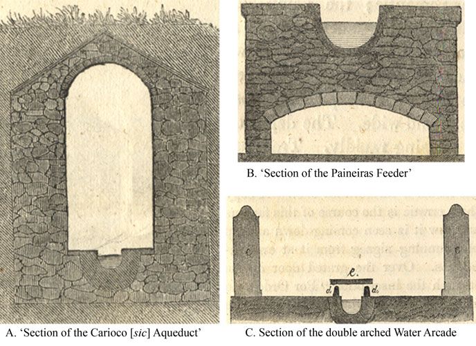
Urban History             3

           Additional historical maps, as well as a modern field study, allow us to confirm the
           aqueduct’s historical route. Ewbank’s observations of water carriers in the city, in
           addition to accounts of others, allow us to reconstruct the fundamental role of
           the enslaved water carrier within the city.

           Are travellers to be trusted?
           As Edward Said explained in Orientalism, historians must consider the precon-
           ceived perceptions of places and peoples carried by ‘eyewitness’ travellers, as well
           as how the genre of travel writing is deeply intertwined with power dynamics.7
           For Said, travellers are fundamental to the discourse that created the idea of the
           Orient. A scientist, scholar, missionary, trader and soldier could think about the
           Orient, Said argues, ‘because he could be there, or could think about it, with very
           little resistance on the Orient’s part’. Travellers, in Said’s view, were highly influ-
           enced by a vision of two worlds – the Orient – ‘them’ – and the West – ‘us’.
           This limited what the traveller could see, even as he or she benefited from ‘a certain
           freedom of intercourse [that] was always the Westerner’s privilege’.8
               Travel literature is a complex genre, and the critical analysis of these reports has been
           a major theme of academic study since the publication of Orientalism.9 Travel accounts
           have always been important sources for scholars of Latin America because of their
           descriptive texts, often supplemented with engraved plates.10 In the case of Rio de
           Janeiro, there is an extensive literature written by travellers who landed in the city, espe-
           cially after the opening of the port to trade with friendly nations, which occurred with
           the arrival of the Portuguese royal family and court in 1808. Accounts of life in Rio,
           often highly illustrated, circulated in the Atlantic World during the nineteenth century.11
           and topography) and the social landscape (e.g. contemporaneous artists’ renderings of scenes in the city). A
           version of the HGIS is publicly accessible as imagineRio, https://imaginerio.org/, accessed 24 Jun. 2020.
           Recent scholarship has used HGIS to understand the spatial context of topics ranging from environmental
           impacts of industrialization in London to the Louisiana Purchase, to the food provisioning of New York
           City; see J. Clifford, West Ham and the River Lea: A Social and Environmental History of London’s
           Industrialized Marshland, 1839–1914 (Vancouver, 2017); R. Lee, ‘Accounting for conquest: the price of
           the Louisiana Purchase of Indian country’, Journal of American History, 103 (2017), 921–42; and
           G. Baics, Feeding Gotham: The Political Economy and Geography of Food in New York, 1790–1860
           (Princeton, 2016). For more on HGIS and spatial history, see A. Knowles and A. Hillier, Placing
           History: How Maps, Spatial Data, and GIS Are Changing Historical Scholarship (Redlands, CA, 2008);
           D. Bodenhamer, J. Corrigan and T. Harris, The Spatial Humanities: GIS and the Future of Humanities
           Scholarship (Bloomington, 2010); and I. Gregory, D. DeBats and D. Lafreniere, The Routledge
           Companion to Spatial History (London and New York, 2018).
              7
               E.W. Said, Orientalism (New York, 1978).
              8
               Ibid., 7, 43–4.
              9
               See R. Bridges, ‘Exploration and travel outside Europe (1720–1914)’, in Peter Hulme and Tim Youngs
           (eds.), The Cambridge Companion to Travel Writing (Cambridge, 2002), 53–69; and M.B. Campbell, ‘Travel
           writing and its theory’, in ibid., 261–78.
              10
                For analytical approaches to travel writing as it pertains to Latin America, see M.L. Pratt, Imperial Eyes:
           Travel Writing and Transculturation, 2nd edn (New York, 2008); and M. Brown, ‘Richard Vowell’s
           not-so-imperial eyes: travel writing and adventure in nineteenth-century Hispanic America’, Journal of
           Latin American Studies, 38 (2006), 95–122.
              11
                Among the most famous are J.B. Debret, Voyage pittoresque et historique au Brésil…, 3 vols. (Paris,
           1834); and J.M. Rugendas, Voyage pittoresque dans le Brésil / par Maurice Rugendas; traduit de l’allemand
           par M. de Golbéry,… (Paris, 1835).

Downloaded from https://www.cambridge.org/core. IP address: 46.4.80.155, on 03 Jan 2022 at 23:40:06, subject to the Cambridge Core terms of
use, available at https://www.cambridge.org/core/terms. https://doi.org/10.1017/S096392682000084X
4        Metcalf, Smith and Kennedy

                 Brazilian historians have long known that travellers to Brazil fell into similar
             habits, reproducing the same written descriptions and repeating similar visual
             tropes believed to signify Brazil.12 Nineteenth-century travellers positioned them-
             selves as superior outsiders, capable of describing the nature of ‘Rio’ to those
             who would not visit. Historians can trace citations in the travel literature, indicating
             that travellers to Rio often quoted those writers who came before them and
             expected to have their work mentioned in turn by future visitors.13 When travellers
             repeated descriptions and adopted characterizations of previous travellers, they
             reinforced stereotypes that came to be associated with the city. Traveller accounts,
             therefore, are held by many historians as unreliable and more revealing of the trav-
             eller than of the places visited.14
                 Nevertheless, the travel literature has been deemed useful by historians of Brazil
             because of the absence of other sources, such as diaries and personal correspond-
             ence. Travellers wrote voluminously, and they often noticed patterns of daily life.
             Most visitors to Rio in the nineteenth century commented on Rio’s water – its
             source in the Tijuca Forest, its monumental arched aqueduct, its public fountains
             and its water carriers. Even though this commentary is influenced by European
             bias and racism, it is still revealing to historians seeking to reconstruct the city’s
             water infrastructure.
                 The writings of travellers can be insightful when read carefully, when racial and
             ethnic bias is recognized and questioned and when specific descriptions are
             unpacked for underlying meanings. When Adèle Toussaint-Samson wrote about
             the group’s stop at Dois Irmãos (Two Brothers), a place along the aqueduct in
             Santa Teresa, her description of water is illuminating. Toussant-Samson wrote
             ‘the negroes filled the canecas (tin cans) with pure and sparkling water, of which
             Europeans can have no idea’. In this simple sentence Toussaint-Samson comments
             on the poor quality of water in European cities of the time and suggests the super-
             iority of the water in Rio. At the same time, she alludes to the fundamental role of
             slaves in the city by noting that slaves served water to her and to others in her
             party.15 Although on the surface this would seem to be a simple act – offering a
             drink of water – in fact Toussaint-Samson captures in miniature what happened
             all across the city: in Rio, slaves delivered the water. The same association is
             made by the Reverend Robert Walsh, who was in Rio in 1828–29 as chaplain to
             the British Ambassador Extraordinary Viscount Strangford. Walsh’s observation
             is made with blatant and disturbing racism. Walsh writes that Rio’s water ‘as it is
             at present conveyed by negroes, is singularly offensive’. For Walsh, the water was
             ‘defiled’ by the black water carriers who delivered water through Rio’s streets. ‘It
             is impregnated with the perspiration that streams from their naked bodies’, he
             states, ‘and they constantly thrust their hands and arms in the bottom of their
             cans for any purpose; and the water there has always a foul look and bad odour.’
             Walsh’s comments reveal explicitly his view that black water carriers polluted the
                 12
                  L. de L. Martins, O Rio de Janeiro dos viagantes: o olhar britânico, 1800–1850 (Rio de Janeiro, 2001).
                 13
                  Said emphasizes how Orientalists cited each other, and a similar pattern can be seen in the travel
             accounts for Rio. For example, sea captains often repeated Cook’s observation on the water in Rio.
                14
                  M.G. Aune, ‘Early modern European travel writing after Orientalism’, Journal for Early Modern
             Cultural Studies, 5 (2005), 121 and passim.
                15
                  Toussaint and Toussaint, Parisian in Brazil, 52.

Downloaded from https://www.cambridge.org/core. IP address: 46.4.80.155, on 03 Jan 2022 at 23:40:06, subject to the Cambridge Core terms of
use, available at https://www.cambridge.org/core/terms. https://doi.org/10.1017/S096392682000084X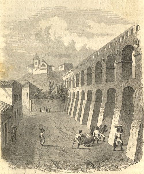
Urban History             5

           ‘pure, limpid, and cold’ water of the Carioca Aqueduct. His racist comments also
           suggest his underlying fear of the power of the black water carrier, as well as the
           city’s dependence on slaves for basic needs.16
              Is Ewbank’s account to be trusted? He claims that the Office of Public Works in
           Rio had no historical documents describing the building of the Carioca Aqueduct,
           and that he received permission from a ‘Colonel Frias, distinguished superintend-
           ent of the Public Works’ to study the aqueduct himself.17 On the surface, this seems
           like an exaggerated claim, and one loaded with the bias of an outside observer.
           However, key elements of this claim can be verified. Archival research in Rio uncov-
           ered an A. Miguel de Frias e Navares, holding the title of Inspector Geral das Obras
           Públicas (Inspector General of Public Works), who signed a document on 18 May
           1849, making it likely that Ewbank did at least know of the leadership in the Office
           of Public Works in Rio.18 Similarly, extensive searches for documents about the
           construction of the Carioca Aqueduct have found documents only in the
           Archivo Historico Ultramarino (Overseas Historical Archive) in Lisbon.19 Only
           documents pertaining to maintenance of the aqueduct and its fountains in the
           nineteenth century are to be found in Rio, largely in the Arquivo Geral da
           Cidade do Rio de Janeiro. This suggests that the Office of Public Works in Rio likely
           did not have in its possession any of the historical documents on the construction
           of the Carioca Aqueduct. The documentation the office preserved would have per-
           tained to works completed in the nineteenth century, suggesting that Ewbank’s
           claim is substantially true.

           How unique is Rio’s water system?
           Despite its name, Rio de Janeiro does not lie on a river. This makes it different from
           most cities that have grown organically alongside rivers that supply a continuous
           source of fresh water. Yet, like other colonial cities, Rio was founded to serve the
           colonial enterprise. The Ordinances of King Phillip II (1573) established principles
           for the creation of cities in the Spanish American colonies, and one of the first was
           that the site for a city must have access to good water.20 The Portuguese organized
           their colonial settlements differently, given that their initial focus was on maritime
           trade rather than defending huge territories. Early Portuguese colonial settlements

               16
                R. Walsh, Notices of Brazil in 1828 and 1829 (London, 1830), 507–8, 496.
               17
                A. Miguel de Frias e Navares, holding the title of Inspector Geral das Obras Públicas, signed a docu-
           ment on 18 May 1849; see Abastecimento d’água: aquedutos: Carioca, Laranjeiras e Maracanã, 51.1.12, 29,
           AGCRJ, making it likely that Ewbank did at least know of the superintendant of the Office of Public Works
           in Rio. Similarly, the documents that describe the construction of the Carioca Aqueduct are today to be
           found in the Archivo Histórico Ultramarino in Lisbon. These may be found in the Projeto Resgate:
           Biblioteca Luso Brasileira, available through the Biblioteca Nacional Digital Brasil. Documents pertaining
           to maintenance of the aqueduct and its fountains in the nineteenth century are to be found in Rio, in
           the AGCRJ.
              18
                Abastecimento d’água: aquedutos: Carioca, Laranjeiras e Maracanã, 51.1.12, 29, AGCRJ.
              19
                These are available in Projeto Resgate – Rio de Janeiro Avulsos (1614–1830), Biblioteca Luso-Brasileira,
           http://resgate.bn.br/docreader/docmulti.aspx?bib=resgate&pagfis=, accessed 24 Jun. 2020.
              20
                On the Spanish colonial urban planning principles, see J. Kinsbruner, The Colonial Spanish-American
           City: Urban Life in the Age of Atlantic Capitalism (Austin, 2005), 1–12, 23–32; and D. Stanislawski, ‘Early
           Spanish town planning in the New World’, Geographical Review, 37(1947), 94–105.

Downloaded from https://www.cambridge.org/core. IP address: 46.4.80.155, on 03 Jan 2022 at 23:40:06, subject to the Cambridge Core terms of
use, available at https://www.cambridge.org/core/terms. https://doi.org/10.1017/S096392682000084X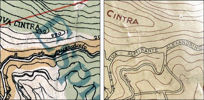
6       Metcalf, Smith and Kennedy

             resembled fortified commercial entrepôts. Fifteenth-century examples, such as
             Arguim or São Jorge da Mina in West Africa, were designed for few residents,
             all of whom served as employees of the crown.21 Rio de Janeiro fell between the
             Portuguese and the Spanish patterns: it served as a fortified site to protect trade,
             but it also supported the missionary outreach of the Jesuits and the first settlers
             who were granted lands for cultivation. Rio soon developed an upper/lower city lay-
             out not uncommon in the Portuguese colonial world.22 The top of the hill known
             as the Morro do Castelo (Castle Hill) served as the city centre, while the beachfront
             functioned on behalf of trade. However, as the city began to descend gradually from
             the Morro do Castelo, it expanded along the lower beachfront that fronted the har-
             bour where there was no easy access to fresh water. Whereas wells could be sunk on
             the Morro do Castelo, the lower city spread over reclaimed swamps and lagoons
             making the digging of decent wells impossible. In the early eighteenth century,
             after considerable investment by the crown, the aqueduct began to deliver water.
             In 1750, the monumental double arched water bridge connected Morro de Santa
             Teresa (Santa Teresa Hill) to Morro do Santo António (Santo Antonio Hill) and
             brought water to the south-western edge of the city. At that time, the city had
             two public fountains. More fountains were built in the second half of the eighteenth
             century, but when the prince regent, ailing queen and the rest of the royal family
             and court arrived in 1808, Rio still relied on the Carioca Aqueduct. Water carriers,
             the majority of whom were enslaved peoples of African descent, filled water vessels
             and carried the water through the city streets.23
                 Rio was not unique in its dependence on an aqueduct. Other cities in colonial
             Latin America used aqueducts, the most famous being Mexico City. Beginning in
             Aztec times, Tenochtitlan relied on an aqueduct to bring water from
             Chapultepec, and following the conquest, life in Mexico City continued to be con-
             tingent on an aqueduct to deliver fresh water. By the end of the eighteenth century,
             a second major aqueduct had been built, and the city had 20 public fountains.
             Public buildings, such as hospitals, had their own private access to water from
             the aqueducts.24 The city of Havana, which like Rio was a fortified port city, had
             an aqueduct that was finished by the end of the sixteenth century. The aqueduct
             brought water from the Almendares River west of the city. As in Rio, Havana’s
             aqueduct fed public fountains that were open to all, and as in Rio, Havana suffered
             from periodic water shortages.25 Other capital cities, such as Buenos Aires, were
             located on rivers, which provided direct access to water to residents. In Buenos
             Aires, the ribera – riverfront – was by law and custom a commons, and residents

                21
                  R.C. Smith, ‘Colonial towns of Spanish and Portuguese America’, Journal of the Society of Architectural
             Historians, 14 (1955), 3–12; D. Birmingham, ‘The Regimento da Mina’, Transactions of the Historical
             Society of Ghana, 11 (1970), 1–7.
                22
                  Smith, ‘Colonial towns’.
                23
                  A.C. Metcalf, ‘Planning for water in colonial Rio de Janeiro’, unpublished manuscript.
                24
                  S.B. Glasco, Constructing Mexico City Colonial Conflicts over Culture, Space, and Authority (New York,
             2010), 77–90; B.E. Mundy, The Death of Aztec Tenochtitlan, the Life of Mexico City (Austin, 2015), 190–
             208.
                25
                  P.B. Niell, ‘Rhetorics of place and empire in the fountain sculpture of 1830s Havana’, The Art Bulletin,
             95 (2013), 445; M.M. Portuondo, ‘Una Obra maestra: el acueducto Albear de La Habana (review)’,
             Technology and Culture, 46 (2005), 203–5.

Downloaded from https://www.cambridge.org/core. IP address: 46.4.80.155, on 03 Jan 2022 at 23:40:06, subject to the Cambridge Core terms of
use, available at https://www.cambridge.org/core/terms. https://doi.org/10.1017/S096392682000084X
Urban History             7

           bathed, fished, did laundry and collected water for home use directly from the river.
           Water sellers generally drew water above the city, while laundresses washed directly
           on the banks along the city.26
              Colonial patterns continued in the nineteenth century, at least until 1850. In
           nineteenth-century Mexico City, neighbourhoods outside of the city centre did
           not have easy access to water. The same was true as Rio began to grow rapidly in
           the nineteenth century. Mexico City, like Rio, relied on water carriers. But unlike
           Rio, the water carriers in Mexico City were free, and they were part of the working
           class of the city, even if on its lowest rungs. Because of the inaccessibility of foun-
           tains in the distant neighbourhoods, water sellers in Mexico City could charge high
           sums for their water, which made water expensive for the poor who lived outside of
           the city centre.27 A huge new aqueduct was planned for Havana when at mid-
           century the limitations of its water supply were recognized by the Spanish
           crown. Other investments, such as in fountains, plazas and alamedas, suggest
           that Spain saw the benefit of spending lavishly on public works and public spaces
           that benefited the local elites in its remaining colonies.28
              The elements of Rio’s water system were not in and of themselves unique, for
           other Latin American cities had aqueducts, public fountains and water carriers.
           What does seem to be distinguishing is the excellent but limited supply of water
           that the city could expect and the large number of slaves forced to carry it. As
           the city began to grow rapidly in the nineteenth century, a second aqueduct had
           to be built, and more fountains had to be opened. But there was no replacement
           for the slaves who continued to deliver water even when the first independent
           water sellers began to operate. The degree to which the city relied on urban slavery
           to complete the water cycle does seem to be a distinctive feature of Rio de Janeiro.
           This fact makes the ending of the transatlantic slave trade in 1850 a significant
           moment in the history of the city, for after 1850 it would become less likely that
           the city could continue to depend on slaves to deliver its water.

           The Carioca Aqueduct
           Named for the Carioca River that rose at the base of the Corcovado Peak, the con-
           struction of the aqueduct began as early as 1659. Rio’s first public fountain, placed
           in the square at the back of the city below the monastery of Santo António, began to
           flow in 1723. The square soon became known as the Largo da Carioca (Carioca
           Square), named for the fountain and its water source. The fountain itself was
           designed in Lisbon; its stones cut and shipped from Portugal. The aqueduct became
           monumentally visible when the double arched arcade – known today as the Arcos
           da Carioca (Carioca Arches) or the Arcos da Lapa (Lapa Arches) – was finished by
           the viceroy in 1750, replacing an older part of the original aqueduct. At this time, a
           second major fountain, also designed and shipped from Lisbon, delivered water to
                B. Bockelman, ‘Along the waterfront: Alejandro Malaspina, Fernando Brambila, and the invention of
               26

           the Buenos Aires cityscape, 1789–1809’, Journal of Latin American Geography, 11 (2012), 72, 76.
              27
                Glasco, Constructing Mexico City Colonial Conflicts, 77–90; M.E. Francois, A Culture of Everyday
           Credit: Housekeeping, Pawnbroking, and Governance in Mexico City, 1750–1920 (Lincoln, NB, 2006), 91, 92.
              28
                L.A. Pérez, Intimations of Modernity: Civil Culture in Nineteenth-Century Cuba (Chapel Hill, 2017),
           32–8, 78; Niell, ‘Rhetorics of place and empire’, 459–60.

Downloaded from https://www.cambridge.org/core. IP address: 46.4.80.155, on 03 Jan 2022 at 23:40:06, subject to the Cambridge Core terms of
use, available at https://www.cambridge.org/core/terms. https://doi.org/10.1017/S096392682000084X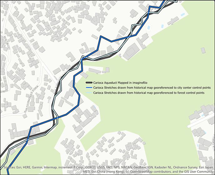
8        Metcalf, Smith and Kennedy

             the main square that opened on one side to the Guanabara Bay. Fed by the Carioca
             Aqueduct, the water came to the new fountain from the Carioca fountain via
             underground pipes. This fountain was replaced in 1775 when the square was modi-
             fied, but this time the new fountain was designed and built in Rio. Moved from the
             centre of the square to the waterfront, the second fountain on the seawall gave eas-
             ier access to ships seeking to replenish their water casks. Other fountains were built
             in the late eighteenth century, bringing the total number of public fountains in the
             city to nine when the Portuguese royal court, fleeing Napoleon, landed in 1808.29
                 By the time Thomas Ewbank arrived in Rio in 1846, a second aqueduct – the
             Maracanã – had been constructed, as well as several new fountains.30 His account
             focuses only on the original aqueduct – the Carioca. Nevertheless, Ewbank’s
             account stands out from many other observations made about the Carioca
             Aqueduct31 because he shows how it worked and why it delivered, except in
             times of heavy rains, uncontaminated water directly from the Tijuca Forest into
             the city. Several illustrations accompany the text, and these appear to be based
             on sketches by Ewbank that were later engraved for the publication by Lossing
             and Barritt.32 The text and sketches work together. For example, before beginning
             the first ascent, while waiting for their horses and guide under the water bridge
             arcade on the Rua dos Arcos, Ewbank describes the scene in words and includes
             an illustration (Figure 1):

                 At our right towered a part of the aqueduct arches; facing us arose the dead
                 wall of the Teresa Convent garden, and…[p]rojecting from the wall are spouts
                 to supply the vicinity with water. Not less than two dozen slaves, of both sexes,
                 came to fill their barils [sic] during the few minutes we waited, several of
                 whom carried the liquid high up the hill down which it comes.33

                In the illustration, Ewbank positions each of the features of water delivery that he
             describes in the text. The double arched arcade is massive and dominates the image.
             The Rua dos Arcos (Street of the Arches) passes beneath, and on the street can be
                 29
                    Metcalf, ‘Planning for water’.
                 30
                    For the Maracanã Aqueduct, see A.C. Metcalf and S.M. Smith, ‘Mapping the Maracanã Aqueduct:
             reconstructing the route of Rio de Janeiro’s second major aqueduct’, e-Perimetron, 13 (2018), 1–22,
             http://www.e-perimetron.org/Vol_13_1/Metcalf_Smith.pdf, accessed 24 Jun. 2020.
                 31
                    British visitors penned many accounts of the aqueduct, especially sea captains who reprovisioned their
             ships with water and food in Rio. These accounts are useful but do not describe the aqueduct in detail. For
             example, Cook wrote in his journal in 1768: ‘The city of Rio de Janeiro is supplied with Water from 2
             Different parts of the Adjacent Mountains. That which comes from the Southward is Convey’d a Cross
             a Deep Valley by an Acquiduct, which Consists of a great Number of Arches placed in 2 Rows, one
             upon the other; from thence in pipes to a fountain which stands in the Middle of the Square before the
             Vice-Roy’s Palace’, in W.J.L. Warton (ed.), Captain Cook’s Journal during the First Voyage Round the
             World, Made in H.M. Bark ‘Endeavor’ 1768–71 (London, 1893), Project Gutenberg, www.gutenberg.org/
             files/8106/8106-h/8106-h.htm, accessed 24 Jun. 2020.
                 32
                    Benson J. Lossing and William Barritt had an engraving company in New York, dating from 1838 and
             still in business in 1862; see ‘Oldest wood engraving establishment in New York’, Broadside, sm # Am 1862
             Lossing 14874.Q (Zinman), Library Company of Philadelphia, https://digital.librarycompany.org/islandora/
             object/Islandora%3A6298, accessed 24 Jun. 2020.
                 33
                    Ewbank, Life in Brazil, 409.

Downloaded from https://www.cambridge.org/core. IP address: 46.4.80.155, on 03 Jan 2022 at 23:40:06, subject to the Cambridge Core terms of
use, available at https://www.cambridge.org/core/terms. https://doi.org/10.1017/S096392682000084X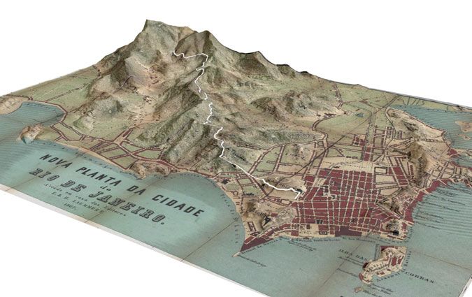
Urban History             9

           Figure 1. Double arched water bridge with water carriers
           Source: ‘Arcos Street’, in Ewbank, Life in Brazil, 409.

           seen a huge water cask set on a small flat platform with wheels, pulled by slaves. The
           Santa Teresa convent rises on a hill, and below it, at street level, is a wall from which
           extends a pipe, with a stone basin beneath. A slave woman appears to be filling a
           water vessel, and another slave woman is shown on the street, with a water vessel on
           her head. This vessel is the barril which elsewhere Ewbank will illustrate and also
           remark that it holds about seven gallons, giving it a weight of at least 70 pounds
           (31.75 kilogrammes).34
              Ewbank was not far into his observations of the Carioca Aqueduct when he
           made a surprising analogy: the long aqueduct with its magnificent double arched
           water bridge was ‘a mere gutter!’ By this, he did not mean that the water was
           dirty; rather, that the size of the channel was small, similar in size to that of a
           rain gutter. This realization came after Ewbank left the water bridge arcade during
           his ascent of the Morro de Santa Teresa. Ewbank noticed ‘a stone fence or stuccoed

               34
                Here we use the British standard: the imperial gallon, rather than the Queen Anne’s gallon, then used
           in the US. A standard imperial gallon of water weighs 10 pounds (vs. the 8.34 pounds of the Queen Anne’s
           gallon); see ‘Imperial units’, Britannica Academic, Encyclopædia Britannica, 20 Sep. 2019.
           academic-eb-com.ezproxy.rice.edu/levels/collegiate/article/Imperial-units/16522, accessed 4 Jan. 2020.

Downloaded from https://www.cambridge.org/core. IP address: 46.4.80.155, on 03 Jan 2022 at 23:40:06, subject to the Cambridge Core terms of
use, available at https://www.cambridge.org/core/terms. https://doi.org/10.1017/S096392682000084X
10        Metcalf, Smith and Kennedy

             Figure 2. Ewbank’s cross sections of the Carioca Aqueduct
             Source: Ewbank, Life in Brazil, 412, 425, 427.

             wall, varying from five to eight feet in height’ in places ‘capped with peaked ridges’.
             Initially, he took it to be a support, to prevent the mountainside from sliding down
             and blocking the steep path that led up to the convent. The guide told him, how-
             ever, that the wall was hollow and part of the aqueduct. Ewbank writes, ‘I dis-
             mounted, put my ear to one of the openings, and, sure enough, heard the sound
             of rushing water.’ Assuming that the water filled the space, he asked how high
             up the 21-inch thick walls the water reached. The guide replied that the water
             never reached the walls. Rather, the water remained in a small, ‘semi-circular chan-
             nel, cut in granite slabs laid at the bottom’. Higher up, Ewbank entered this hollow
             wall, which he described as tall enough for him to stand erect and almost wide
             enough for two people to walk abreast. He estimated the size of the water channel
             as at most only 9½ inches deep by 9 inches wide.35
                Ewbank sketched a cross section of the aqueduct, and for this illustration, he
             chose a place where, to preserve the downward flow, the aqueduct had been posi-
             tioned underground. As can be seen in Ewbank’s cross section of the inside of the
             aqueduct (Figure 2A), the entire aqueduct is covered with earth. But more import-
             ant is the inside, and here Ewbank carefully rendered thick walls, the roof with a
             steep pitch on each side, and the granite slab at the bottom that channelled the
             water.
                Ewbank noticed that central to the working of the aqueduct were the caixas
             (water boxes or holding tanks) that had been built in key locations. Some of the
                35
                  Ewbank, Life in Brazil, 411–12.

Downloaded from https://www.cambridge.org/core. IP address: 46.4.80.155, on 03 Jan 2022 at 23:40:06, subject to the Cambridge Core terms of
use, available at https://www.cambridge.org/core/terms. https://doi.org/10.1017/S096392682000084X
Urban History 11
Figure 3. Aqueduct and caixas
Sources: Left: ‘Aqueduct and caixa’, in Ewbank, Life in Brazil, 411. Right: ‘Carioco [sic] Aqueduct’, in Ewbank, Life in
Brazil, 429.
caixas had more than one source of water, such as the caixa in Santa Teresa that
had two stretches of the aqueduct leading to it. Ewbank made two sketches that
show stretches of the covered aqueduct reaching and exiting from these water
boxes. In one (Figure 3, left) the Santa Teresa convent appears high on a hill,
and the tall, covered aqueduct descends to a caixa with a peaked roof. In the second
illustration, the aqueduct descends from the hills to a house-like structure, which
served as the caixa, and from it two separate stretches of the aqueduct emerge.
Note that Ewbank posed himself in this illustration, sketching the waterworks
(Figure 3, right).
The course of the aqueduct, Ewbank observed, consisted of straight stretches that
changed directions every few feet. Periodically, Ewbank found locked gates through
which water could be extracted from small basins; these openings had been
constructed to allow those living on the chácaras (small farms or villas) nearby to
obtain water. Ewbank entered through one of these unlocked gates – 4 feet
square – and walked along the aqueduct. Inside, he noted ‘sufficient light’ supplied
by 10 x 7-inch openings every 15 or 20 feet. He writes, ‘the little stream gurgled as
it rushed between my feet, and boiled and foamed in the basin at the grating’.36
Above the Santa Teresa convent, a ‘narrow and grassy road’ followed the aque-
duct, ‘seldom less than five feet high’. On one side, Ewbank writes, is ‘a forest preci-
pice’; on the other, the aqueduct, sometimes with a ‘velvet foot-path’ along its roof.
Eventually, they reached ‘Mai de Agua’ (Mãe d’Água) which Ewbank correctly
translates as ‘the Mother of Waters’. He writes that it consisted of ‘a rude basin,
some thirty feet by twelve, formed in the rock, and having a rural roof over it’.
Ewbank explains that although the water is 15 inches deep, it ‘does not spring
up within it, but comes down, a miniature cataract, from projecting precipices’.
Various springs fed it, the most important being the Carioca River. In addition,
Ewbank names four other springs ‘whose trickling treasures are thus gathered
together. Each is named after the mountain from whose sides, or the cavern out
36
Ibid., 412–13.
Downloaded from https://www.cambridge.org/core. IP address: 46.4.80.155, on 03 Jan 2022 at 23:40:06, subject to the Cambridge Core terms of
use, available at https://www.cambridge.org/core/terms. https://doi.org/10.1017/S096392682000084X12 Metcalf, Smith and Kennedy
Figure 4. Mother of Waters (Mãe d’Água)
Source: ‘The Mother of Waters’, in Ewbank, Life in Brazil, 415.
of which, it gushes.’ All conveyed water through open tiles. Two more springs were
the Silvestre and the Paineiras. In rainy weather, he notes that the springs become
torrents, and to protect the aqueduct below, a system was in place to allow the
excess water to escape over the edge into ‘a yawning gulf’.37 Ewbank’s illustration
(Figure 4) shows the house-like structure that covered the ‘rude basin’, the springs
leading to it, a pipe leading from it and the lush vegetation of the tropical Atlantic
forest that surrounded it.
On one side of the structure, next to where the reservoir joined the aqueduct,
Ewbank described a marble tablet inscribed with the name of the governor and cap-
tain general of Rio de Janeiro, Gomes Freire de Andrade, as well as the date: 1744.38
This plaque can be seen in Ewbank’s sketch; it is visible as a rectangular box on the
back wall, in the lower right of the illustration (see Figure 4). The Mother of Waters
sat below the Corcovado Peak, and after he left it to summit, Ewbank describes the
37
Ibid., 415. Ewbank names the springs, apart from the Carioca, as: the Corcovado, das Velhas, Serra,
Lagurnal and Regilio. The Carioca springs refer to the headwaters of the Carioca River, which flowed
down into the southern part of the city to Larangeiras and there emptied into the Guanabara Bay at
Flamengo beach.
38
Ewbank, Life in Brazil, 414–15.
Downloaded from https://www.cambridge.org/core. IP address: 46.4.80.155, on 03 Jan 2022 at 23:40:06, subject to the Cambridge Core terms of
use, available at https://www.cambridge.org/core/terms. https://doi.org/10.1017/S096392682000084XUrban History 13
Table 1. Gravity flow, Carioca Aqueduct
Distances Feet Fall in feet
Feeders above Mãe d’Agua 14,166 Unknown
Santa Teresa to Mãe d’Agua 18,128 520
Santa Teresa to the last caixa above the water bridge 1,290 230
Water bridge ‘Arcos da Carioca’ 833 5
Unidentified segmenta 54
Total approximate length and fall 34,471 ∼1000
a
Ewbank has two separate sets of figures that do not quite line up. In the text (427) he cites the numbers presented in
Table 1, but at another point, in more tabular form (428), he lists the length from the Mother of Waters to Santo Antonio
Hill as 20,305 feet, and the total length of the feeders as 14,166 feet, which adds up to 34,471 feet. Either there is a
segment he did not describe in the text that he includes in the measurements for the total or there is an error in the
printing.
Source: Numbers reported by Ewbank, Life in Brazil, 427–8.
Paineiras feeder, the longest and most expensive to build. This feeder, which col-
lected the water of the Paineiras stream, flowed mainly through open tiles to
Mãe d’Água except in a few places where a small, raised conduit had been built
on the face of the mountain. Ewbank describes the conduit as slightly more than
3 feet high and 3 feet wide, and notes that it was built over arches with a 3-foot
span. The tiles that carried the water were imbedded in the top, 9 inches deep
and 12 inches wide (see above, Figure 2B).
As for the famous Arcos da Carioca, the monumental double arched water
bridge arcade, Ewbank learned that its water channel was identical in size to that
of the aqueduct above Santa Teresa or to the Paineiras Feeder. Ewbank later mea-
sured the water bridge at 833 feet long; and he counted 40 or 42 arches. In his illus-
tration, his labels identify each part: c = the two parapet walls; d = the two 6-inch
stucco walls; e = the loose boards covering water channel) (see above, Figure 2C).
The distance between the two parapet walls (c), measured 9 feet from outside to
outside, but the waterway itself was created from granite stone or clay tiles, 9 inches
across, and 9 inches deep. The low wall, 6 inches above the waterway (d ), prevented
the channel from overflowing and served as the support for the loose boards (e) that
covered the water channel.
On subsequent visits, Ewbank measured the length of the aqueduct above Santa
Teresa segment by segment, using a pole, a straight-edge and a level. He reported
that there was great variation in the amount of the fall, but no stretch delivered
water at less than a fall of 4 inches in 15 feet.39 From the Mother of Waters to
Santa Teresa, the fall was over 500 feet, from Santa Teresa to the last caixa before
the water bridge, the fall was 1 foot in 5 feet for a total of 230 feet, while across the
833 foot-long water bridge, the fall was 5 feet (see Table 1). The entire length of the
aqueduct had been measured by the Office of Public Works, and Ewbank gives
their figures as 4,543 braças.40 Converting braças into feet, and adding in the
total fall, he gives the length and fall of the Carioca Aqueduct as 34,471 feet
with a fall of 1,000 feet (see Table 1).
39
Ibid., 410.
40
The braça is generally accepted as equal to 7.3 feet.
Downloaded from https://www.cambridge.org/core. IP address: 46.4.80.155, on 03 Jan 2022 at 23:40:06, subject to the Cambridge Core terms of
use, available at https://www.cambridge.org/core/terms. https://doi.org/10.1017/S096392682000084X14 Metcalf, Smith and Kennedy
Figure 5. Map of Rio de Janeiro, 1858
Source: Carneiro de Campos et al., Planta da Cidade do Rio de Janeiro, 1858. Geography and Map Division, Library of
Congress, http://hdl.loc.gov/loc.gmd/g5404r.ct003652, available in imagineRio 1858.
On the map titled Planta da Cidade do Rio de Janeiro (1858) (see Figure 5),
Brazilian military engineers drew the route of the Carioca Aqueduct, which
began in the forest well beyond the city centre.41 The aqueduct appears in segments,
as Ewbank describes. Ewbank measured 214 stretches of the aqueduct between the
Mãe d’Água to Santa Teresa Hill, describing them as all straight lines; each segment
joined the next at an angle ‘more or less obtuse, seldom acute’.42 Each segment had
a different length, most under 100 feet, and a few smaller than 30. The map repro-
duces Ewbank’s basic point: the aqueduct consisted of segments of different sizes
that were joined together at angles of varying degree. The 1858 map, however,
shows only about 160 segments.43 It is difficult to pinpoint how Ewbank or the
military engineers differentiated between each stretch.
Advances in computer technology allow us to re-examine the differences
between Ewbank’s account and the historical map of Rio de Janeiro that presents
the path of the aqueduct. When a historical map is digitized and georeferenced,
tools in GIS help to approximate the location of the aqueduct over modern ter-
41
F. Carneiro de Campos et al., Planta da Cidade do Rio de Janeiro (Rio de Janeiro, 1858), available
through the Geography and Map Division, Library of Congress, http://hdl.loc.gov/loc.gmd/g5404r.
ct003652, accessed 24 Jun. 2020, also available georeferenced in imagineRio 1858, https://imaginerio.org,
accessed 24 Jun. 2020.
42
Ewbank, Life in Brazil, 427.
43
Many of the segments are clearly discernible, but some lack definition and blend together. After mul-
tiple counts, we feel confident the map shows between 155 and 167 segments.
Downloaded from https://www.cambridge.org/core. IP address: 46.4.80.155, on 03 Jan 2022 at 23:40:06, subject to the Cambridge Core terms of
use, available at https://www.cambridge.org/core/terms. https://doi.org/10.1017/S096392682000084XUrban History 15
Figure 6. Traced segments of the Carioca Aqueduct, over georeferenced map of 1858
Source: Carneiro de Campos et al., Planta da Cidade do Rio de Janeiro, 1858. Geography and Map Division, Library of
Congress, http://hdl.loc.gov/loc.gmd/g5404r.ct003652, available in imagineRio 1858.
rain.44 In the historical GIS (HGIS) we created a digital reconstruction of the path
of the Carioca Aqueduct between Santa Teresa and the Mother of Waters by tracing
the segments on the 1858 map (see Figure 6).
When we overlaid the segments onto a topographic layer in the HGIS, the aque-
duct appeared to have little regard for the terrain. Moreover, when we compared
several georeferenced historical maps in our HGIS, in order to capture details
‘Georeferencing is the GIS process of adding spatial information to a map or image…By creating links
44
on the historical maps to persistent locations also found in modern spatial datasets (e.g. street intersec-
tions), the GIS software situates the historical map image in the correct spatial scale, arrangement, and
dimensions’, see S.W. Kennedy, ‘Lowering mortality: a spatial history of segregation, environments, and
mortality transitions in New Orleans, 1880–1915’, Rice University Ph.D. dissertation, 2018, https://schol-
arship.rice.edu/handle/1911/105865, fn. 24, accessed 24 Jun. 2020. Georeferencing allowed us to digitize
historical spatial features, such as the Carioca Aqueduct, from the original maps. The aqueduct’s path
through the mountainous regions made it difficult to map in the eighteenth and nineteenth centuries.
As will be shown below, the drawing of the aqueduct must be done against modern basemaps in consult-
ation with direct observation, in order to obtain an accurate path.
Downloaded from https://www.cambridge.org/core. IP address: 46.4.80.155, on 03 Jan 2022 at 23:40:06, subject to the Cambridge Core terms of
use, available at https://www.cambridge.org/core/terms. https://doi.org/10.1017/S096392682000084X16 Metcalf, Smith and Kennedy
about the Carioca Aqueduct from different moments in time, we encountered an
accuracy problem. The route of the aqueduct as traced from the 1858 map did
not always match the route of the aqueduct on other georeferenced historical maps.
We looked to other sources to inform a better digital reconstruction of the aque-
duct’s path. Street names can contain useful historical information, even as names
change over time. A city map from 1923 has a detailed list of street names, includ-
ing the Rua do Aqueducto (Aqueduct Street) which runs from the Reservatório da
Carioca (Carioca Reservoir) – on the site of the Mother of Waters – down through
the Tijuca Forest into the neighbourhood of Santa Teresa.45 A city map a decade
later no longer has a Rua do Aqueduto, but a new name: Rua Almirante
Alexandrino (Admiral Alexandrino Street), which is the modern street name.46
Figure 7 shows two historical maps, both georeferenced, and both set at the
same location. The Rua do Aqueduto on the 1923 map appears in the same
place as the Rua Almirante Alexandrino on the 1932 map. Only the name has
changed. Thus, the aqueduct must have run along, or very near, the modern street
named Rua Almirante Alexandrino.
The cartographic inaccuracies in the 1858 map became even more apparent
when we first compared the aqueduct segments to a modern street map. The seg-
ments traced from the 1858 historical map did not consistently match the Rua
Almirante Alexandrino. Because the aqueduct descended through the hills, the
nineteenth-century cartographers had difficulties accurately representing the three-
dimensional route of the aqueduct on a two-dimensional map. Although we
attempted to derive the aqueduct’s real-world location from an otherwise accurate
historical map, the map’s imprecision in the hills limited the viability of this
approach.
In the late nineteenth century, when the new sources of water came into the city,
old sources once carried in the Carioca Aqueduct were re-piped and the monumen-
tal water bridge ceased to deliver water into the city centre. Subsequently, the dou-
ble arched arcade was repurposed as a tram line. This line commenced in the city
and reached the Santa Teresa neighbourhood via the water bridge. From Santa
Teresa, the tram line continued up into the Tijuca Forest, following the aqueduct.
This can be seen in many late nineteenth- and early twentieth-century photographs
that show the raised walls and sloped roof of the aqueduct, much as Ewbank drew
them, as well as tram tracks. In Figure 8, the tram tracks are clearly visible next to
the aqueduct, in the neighbourhood known as ‘Sylvestre’ (Silvestre).
The inaccuracies in the 1858 map and our uncertainty about the aqueduct’s
route suggested that a field survey, which we conducted in May 2014, might answer
several questions. We began in Santa Teresa, above the double arched water bridge
and followed the tram tracks along Rua Almirante Alexandrino as far into the
45
C.Q. Bacellar, Planta Geral da Cidade do Rio de Janeiro (Rio de Janeiro, 1923), available through the
Biblioteca Nacional Digital Brasil, http://acervo.bndigital.bn.br/sophia/index.asp?codigo_sophia=13614,
accessed 24 Jun. 2020, also available georeferenced in imagineRio 1923, https://imaginerio.org, accessed
24 Jun. 2020.
46
A.D. Ribeiro, Planta informativa do cento da cidade do Rio de Janeiro: especialmente organizada para o
Guia Briguiet (Rio de Janeiro, 1932), available through the Biblioteca Nacional Digital Brasil, http://acervo.
bndigital.bn.br/sophia/index.asp?codigo_sophia=13544 also available georeferenced in imagineRio 1932,
https://imaginerio.org, accessed 24 Jun. 2020.
Downloaded from https://www.cambridge.org/core. IP address: 46.4.80.155, on 03 Jan 2022 at 23:40:06, subject to the Cambridge Core terms of
use, available at https://www.cambridge.org/core/terms. https://doi.org/10.1017/S096392682000084XUrban History 17
Figure 7. Changes in street names: Rua do Aqueduto (1923) – to Rua Almirante Alexandrino (1932)
Sources: Left: detail from Bacellar, Planta Geral da Cidade do Rio de Janeiro, Biblioteca Nacional Digital Brasil, http://
acervo.bndigital.bn.br/sophia/index.asp?codigo_sophia=13614, available in imagineRio 1923. Right: detail from
Ribeiro, Planta informativa do centro da cidade do Rio de Janeiro: especialmente organizada para o Guia Briguiet,
1932, Biblioteca Nacional, Brasil, http://acervo.bndigital.bn.br/sophia/index.asp?codigo_sophia=13544, available in
imagineRio 1932.
Tijuca Forest as possible. The tram lines we followed stopped at the end of the Rua
Almirante Alexandrino, very close to where the modern Corcovado train track
crosses the Estrada das Paineiras. There, we immediately identified many features
of the old aqueduct. A modern blue historical marker clearly identified the Casa
Mãe d’Água (House of the Mother of Waters). The marker was attached to the
front wall of a nineteenth-century house-like structure that sat next to three massive
water tanks, which were constructed in 1865.47 This is the Reservatório da Carioca
(Carioca Reservoir), which appears in the 1923 city map, but is no longer func-
tional today. When Ewbank reached this location in 1846, the Reservatório da
Carioca was still decades away from being built, yet already the area was critical
to the city’s water infrastructure. He sketched the waterworks structure at this loca-
tion, and his close attention to detail is evidenced by the inclusion of a historical
plaque attached to the side of the building (see Figure 4). Ewbank detailed the loca-
tion in his writings, and he provided an English translation of the text on the pla-
que, which carries the date of 1744. In our 2014 field survey, we found a similar
stone structure near the Reservatório da Carioca that we suspected was part of
the waterworks. Attached to the side of the structure was an old stone plaque,
but the text was nearly illegible due to recent graffiti. After close inspection, we
compared the text of the plaque to the text recorded by Ewbank in 1846, and
they matched. Figure 9 shows the plaque on the side of a structure as we saw it
in 2014. The street, Rua Almirante Alexandrino, appears in front of the stone struc-
ture, and the tram tracks are clearly visible. The inscription is transcribed in
Figure 9, top right, and Ewbank’s description of it appears in Figure 9, bottom
47
‘Caixa de Mãe D´água e Reservatório Carioca ou Caixas do Carioca’, Inventário de Identificação dos
Reservatórios da CEDAE, INEPAC, Secretaria de Estado de Cultura, RJ, http://www.inepac.rj.gov.br/appli-
cation/assets/img/site/4_ficha_carioca.pdf, accessed 24 Jun. 2020.
Downloaded from https://www.cambridge.org/core. IP address: 46.4.80.155, on 03 Jan 2022 at 23:40:06, subject to the Cambridge Core terms of
use, available at https://www.cambridge.org/core/terms. https://doi.org/10.1017/S096392682000084X18 Metcalf, Smith and Kennedy
Figure 8. Anon., ‘Sylvestre’ with tram lines and aqueduct, right
Source: F. da Rosa, Rio de Janeiro (Rio de Janeiro, 1905), 127.
right. Based on this discovery, we were confident that this was the same eighteenth-
century structure and location visited by Ewbank in 1846. This provided a ground-
truthed geographic point of reference for the aqueduct.48
From Mãe d’Água, we turned to follow Rua Almirante Alexandrino downhill,
always alongside the tram track. We used a GPS (Global Positioning System)
receiver to record the route of our survey, and we captured geotagged images
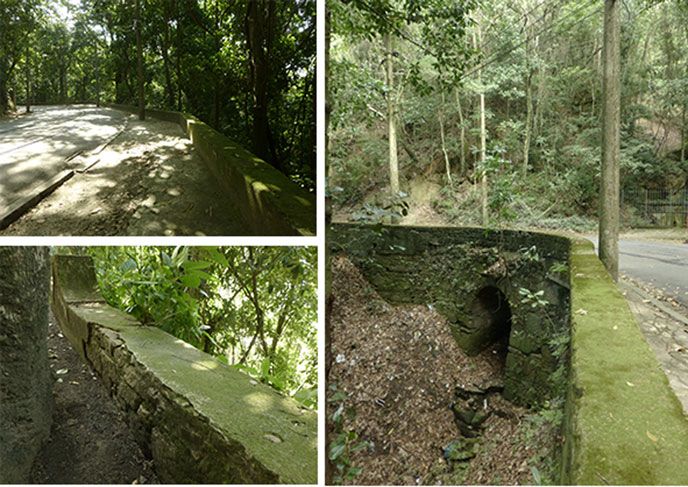
with a camera. A low wall edged the street on the precipice side. The wall had dis-
tinct segments that joined each other at angles, some obtuse, and a few nearing
right angles, just as described by Ewbank. We identified other features of the aque-
duct, such as support arches and locations where springs joined the descent
(Figure 10). Once we arrived in the more populous neighbourhood of Santa
Teresa, it was no longer possible to determine the aqueduct’s historical route due
48
On a later visit, we discovered that the plaque has since been cleaned. There are multiple Google StreetView
images of the plaque; see the approximately 10 different captures between 2010 and 2016: www.google.com/
maps/@-22.9451869,-43.2083479,3a,77.3y,346.02h,93.36t/data=!3m7!1e1!3m5!1sSXCtV6UO6lqKFua_EUzatg!
2e0!5s20141101T000000!7i13312!8i6656, accessed 24 Jun. 2020.
Downloaded from https://www.cambridge.org/core. IP address: 46.4.80.155, on 03 Jan 2022 at 23:40:06, subject to the Cambridge Core terms of
use, available at https://www.cambridge.org/core/terms. https://doi.org/10.1017/S096392682000084XYou can also read