Transport Study in Support of the Shipley and Canal Road Corridor - AAP
←
→
Page content transcription
If your browser does not render page correctly, please read the page content below
Transport Study in        City of Bradford MDC
Support of the Shipley
and Canal Road Corridor
AAP

                          Our ref: 22669801
May 2015                  Client ref: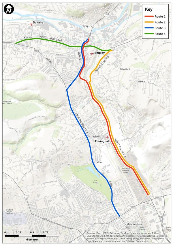
Transport Study in                                    City of Bradford MDC
Support of the Shipley
and Canal Road Corridor
AAP

                                                      Our ref: 22669801
May 2015                                              Client ref:

Prepared by:                                          Prepared for:

Steer Davies Gleave                                   City of Bradford MDC
67 Albion Street                                      Department of Regeneration and
Leeds LS1 5AA                                         Culture
                                                      2nd Floor South
                                                      Jacobs Well
                                                      Bradford BD1 5RW
+44 113 389 6400
www.steerdaviesgleave.com

Steer Davies Gleave has prepared this work for City of Bradford MDC. This work may only be used within
the context and scope of work for which Steer Davies Gleave was commissioned and may not be relied
upon in part or whole by any third party or be used for any other purpose. Any person choosing to use
any part of this work without the express and written permission of Steer Davies Gleave shall be
deemed to confirm their agreement to indemnify Steer Davies Gleave for all loss or damage resulting
therefrom. Steer Davies Gleave has prepared this work using professional practices and procedures
using information available to it at the time and as such any new information could alter the validity of
the results and conclusions made.
Contents

Executive Summary....................................................................................................................... i
        Overview ........................................................................................................................................ i
        Growth in demand ......................................................................................................................... i

1       Introduction ....................................................................................................................... 1
        Background ................................................................................................................................... 1

2       Current Situation ................................................................................................................ 2
        Overview ....................................................................................................................................... 2
        Shipley and Canal Road Corridor AAP proposals .......................................................................... 5

3       Future Demand for Travel ................................................................................................... 7
        Growth in Demand ....................................................................................................................... 7
        Impact of growth .......................................................................................................................... 9
        Summary of key issues relating to increased demand for travel ............................................... 10

4       Issues Arising.................................................................................................................... 12
        Evidence Base ............................................................................................................................. 12
        Implications of growth in demand for travel .............................................................................. 12
        Summary of additional issues relating to increased demand for travel..................................... 15

5       Interventions.................................................................................................................... 16
        Proposed schemes ...................................................................................................................... 16
        Testing of highway interventions ............................................................................................... 18
        Matching interventions to issues ............................................................................................... 20
        Policy considerations .................................................................................................................. 20

6       Delivery Plan .................................................................................................................... 23
        Programme for Delivery ............................................................................................................. 23

7       Recommendations............................................................................................................ 25

        Figures
        Figure 2.1: Shipley and Canal Road Corridor AAP......................................................................... 3
        Figure 2.2: Shipley and Canal Road Corridor – connections to the wider district ........................ 4

                                                                                                                                               May 2015
Figure 4.1: Key travel time routes .............................................................................................. 14
    Figure 5.1: Canal Road Cycle Route ............................................................................................ 17

    Tables
    Table 3.1: Total trips – all specific development combined ......................................................... 8
    Table 3.2: Predicted increase in Canal Road corridor bus use, 2030 ........................................... 9
    Table 4.1: Impact on traffic speeds – Shipley and Canal Road Corridor..................................... 13
    Table 5.1: Change in key link flows across between the future Baseline and the Valley Road
    Closure test – 2030, AM and PM peak ....................................................................................... 19

Appendices

A   Future Demand for Travel

B   Use of the SATURN Model

C   Cycle Route Study

D   Test of Interventions

                                                                                                                              May 2015
Transport Study in Support of the Shipley and Canal Road Corridor AAP |
Executive Summary
Overview
The Bradford City Centre and Shipley and Canal Road Corridor Area Action Plans (AAPs) are
being produced as part of the Local Plan for the Bradford District. The AAPs will establish
planning policies and land use allocations to guide development proposals in the city centre
and the Shipley and Canal Road corridor.
This report focusses on the Shipley and Canal Road Corridor AAP and presents an analysis of
the impact of forecast demands on existing networks and identifies a package of potential
interventions, both physical and non-physical, that could be delivered to support growth and
accommodate additional demand. The report should be read in conjunction with the Baseline
Evidence Report.
The baseline report concluded that there are high levels of traffic currently travelling into and
out of the city, and particularly along Canal Road, but offers no prediction of whether future
growth in the study area driven in part by development proposals in each of the AAP areas can
be delivered without adverse effects on the transport network.
The implications for growth and the introduction of existing AAP proposals have been
evaluated using a SATURN traffic model of Bradford district, which has been updated to reflect
forecast increases in demand both at specific sites and across the district.
Growth in demand
For both the City Centre AAP and the Shipley and Canal Road Corridor AAP, City of Bradford
MDC published an Issues and Options Report in March 2013 which identified numerous sites
for development in each of the areas. Although this report is specifically concerned with
transport issues for the Shipley and Canal Road Corridor AAP, the level of development
proposed in adjacent City Centre sites cannot be ignored as it will generate new trips which
interact with corridor traffic. There follows a list of those development proposals to which
specific quantum of changes in land-use, and associated increase in demand, can be allocated.
City Centre
Various residential development sites
Broadway Shopping Centre development (on track for completion late 2015)
Shipley and Canal Road Corridor
New Bolton Woods development (1000-1200 homes)
Bolton Woods Quarry (800-1000 homes)
Shipley East residential proposals (100 homes)
Dockfield Road Area proposals (400 homes)
Mixed use development in Shipley town centre (300 homes)
It has been agreed that the future year for assessment should be 2030, and by 2030 it is
predicted that there will be up to 3,000 new residential units in the Shipley and Canal Road
Corridor.
Overall, the numbers of trips expected to be generated by specific developments in each of
the two AAP areas is summarised in the following table. City centre residential developments
will generate increases in traffic levels out of city centre in the morning, and back in the
evening, despite being aimed at ‘city living’ and a high level of public transport accessibility
and proximity to jobs. It should also be noted that these are predominantly trips forecast to be
May 2015 | i
Transport Study in Support of the Shipley and Canal Road Corridor AAP |
made to parts of the district beyond the immediate city centre, rather than to destinations
outside the district.
Total trips – AAP developments IN OUT
AM peak:
City Centre 592 1062
Shipley and Canal Road Corridor 539 1167
All Trips 1131 2229
PM peak:
City Centre 1021 1168
Shipley and Canal Road Corridor 1178 770
All Trips 2199 1938
Although these forecasts seemingly represent a significant amount of additional traffic, the
forecasts need to be considered alongside general predictions of traffic growth over the
period between now and 2030. Where significant growth is concentrated in a relatively small
number of sites, there is greater potential for impacts to me mitigated through the planning
process and requirements for adequate access arrangements, contributions to public
transport provision and the promotion of non-car modes of travel.
Department for Transport guidance indicates that growth in traffic between 2014 and 2030 is
predicted to reach 35% in the Bradford district.
Implications for growth
The Bradford SATURN model has been used to assess the impact of growth in demand on the
highway network in 2030. Assessment has been undertaken for both the AM and PM peak
hour and it has been acknowledged that flows in the base year model are high when applying
growth.
An initial analysis of the impacts of growth has identified a small number of ‘hot spots’ where
improved highway infrastructure is considered critical to support growth in demand across the
Shipley and Canal Road corridor.
Canal Road –dualling between the Stanley Road and Hillam Road junctions.
Leeds Road/Crag Road junction –reconfiguration of the layout to this junction to provide a
new roundabout, as part of the approved planning conditions for the Shipley East
development.
The Queen’s Road/Manningham Lane and Shipley-Airedale Road/Bolton Road junctions
would both benefit from a programme of monitoring, with a view to potential re-
optimisation of signal timings as trip patterns change in future years.
For each time period, the model predicts that additional demand will be spread across the
whole network with increases in flow predicted over the next 15 years along Canal Road,
Valley Road, Bradford Road and in Shipley. Growth in traffic will also result in general increases
in flow away from the immediate corridor, in areas such as Saltaire.
It is important to recognise that there will be some increase along A657 through the centre of
Saltaire. It is also recognised that work to the Saltaire roundabout, as part of the Connecting
Airedale initiative, has recently been completed.
May 2015 | ii
Transport Study in Support of the Shipley and Canal Road Corridor AAP |
Within the Shipley and Canal Road Corridor, increased demand will result in increases in delay
in the City Centre Fringe area, at the Queen’s Road/King’s Road junction and, in Shipley, at the
junction of Briggate and Valley Road and on approaches to the main Otley Road/Leeds Road
junction in the centre of town.
The modelling supports a conclusion that the Shipley and Canal Road Corridor network is likely
to be able to accommodate the level of development proposed in both AAPs, although there
will be impacts on certain junctions which will require future interventions or mitigation.
This, of course, relies on the mode shares in Bradford and along the Canal Road corridor
remaining at current levels, as a minimum. At current mode share, the New Bolton Woods,
Bolton Woods Quarry and Shipley sites will between them generate 200 new bus trips,
equivalent to 4 additional buses along Canal Road, in each hour. If target mode shares of 20%
could be achieved, similar to shares crossing into the city as a whole, the requirements would
increase to 6 new buses per hour.
Support from developers should be sought to help provide improvements to the public
transport, cycling and walking networks. The cost of improvements should be gathered
through Section 106 and/or Section 278 contributions.
The modelling provides support that future networks can support general growth in the
district and specific growth in the two AAP areas. Growth in demand to 2030 is only expected
to increase the length of an average trip across the network from 18 to 20 minutes and there
will be a corresponding slight reduction in average speed.
Additional proposals
Given the conclusion that future growth, with mitigation, can be accommodated, a number of
additional proposals have been identified which aim to address issues around safety and
accessibility, rather than provide additional capacity. These proposals represent a combination
of schemes already being pursued by the Council, as well as additional proposals identified
during the course of the study. They are:
Canal Road “Greenway” Cycle Route completion
Shipley Station and Frizinghall Station access and car park improvements
Valley Road closure to through traffic
Shipley Eastern Relief Road
Schemes promoting improved walking, cycling and parking facilities cannot be tested in the
SATURN model but can be delivered. The potential closure of Valley Road to through traffic
will impact on current highway capacity and has been modelled. It has been demonstrated
that there are no capacity reasons why such a scheme could not be pursued.
Delivery and funding
Throughout the assessment of anticipated transport conditions in 2030, and the specific
implications for development sites in the City Centre and Shipley and Canal Road Corridor AAP,
a number of assumptions have been made which will need policy support to deliver.
A number of the key schemes outlined in this report will be funded through the West
Yorkshire Plus Transport Fund (WY+TF) or, on the case of the completion of the Greenway
Cycle Route, using money made available through the Cycle City Ambition Grant Programme
“CityConnect 2”.
May 2015 | iii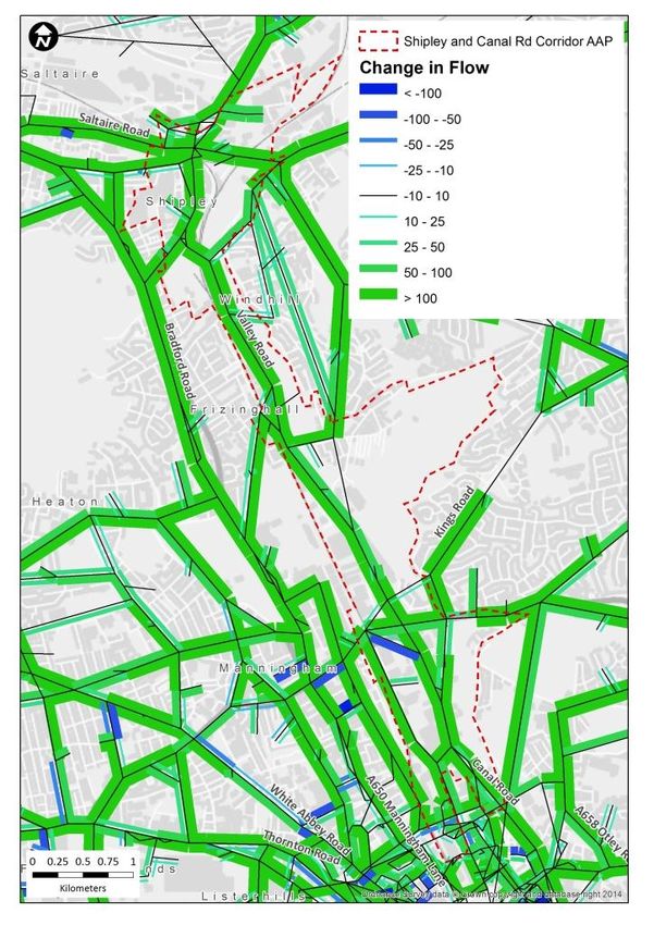
Transport Study in Support of the Shipley and Canal Road Corridor AAP |

However, to support delivery of these schemes, all new development must require a detailed
transport assessment and Travel Plan to be submitted in support of the proposals. Similarly
there is a need to support the use of low vehicular trip rates in the current assessments, and
to encourage use of the various cycling initiatives being implemented or proposed. The
Council’s parking standards must be upheld.
Developers should demonstrate, through their Travel Plans, real commitment to promoting
non-car modes. They should also ensure that all major developments are ‘PT ready’ and that
there are strong connections to local walking and cycling networks.
Section 106 and Section 278 contributions should be used to fund the requirements of
individual development sites. For wider mitigation, which is only identified when a number of
development proposals are considered together, a more holistic approach to funding is
required.
A number of local authorities are developing a Community Infrastructure Levy (CIL), and it is
considered an appropriate approach for Bradford to help secure the projects required to
deliver the proposed growth in the AAP areas to 2030, and beyond. However it must be
recognised that CIL, while being a valuable source of future funding to support delivery, will
unlikely be sufficient on its own to enable delivery of major transport projects.

                                                                                      May 2015 | iv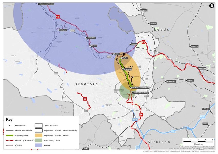
Transport Study in Support of the Shipley and Canal Road Corridor AAP |
1 Introduction
Background
1.1 The Bradford City Centre and Shipley and Canal Road Corridor Area Action Plans (AAPs) are
being produced as part of the Local Plan for the Bradford District. The AAPs will establish
planning policies and land use allocations to guide development proposals in the city centre
and the Shipley and Canal Road corridor.
1.2 Steer Davies Gleave has been commissioned to carry out a robust study of the area and, in line
with the National Planning Policy Framework (NPPF), to determine ‘an adequate and up to
date evidence base’ (NPPF 158) and to ‘assess the ability of infrastructure to meet forecast
demands’ (NPPF 162).
1.3 This report focusses on the Shipley and Canal Road Corridor AAP and presents an analysis of
the impact of forecast demands on existing networks and identifies a package of potential
interventions, both physical and non-physical, that could be delivered to support growth and
accommodate additional demand. The report should be read in conjunction with the Baseline
Evidence Report1.
1.4 The baseline report concluded that:
There are high levels of traffic into and out of the city in the peak hours, and in particular
along the Canal Road corridor.
The percentage of people crossing the city centre cordon by bus has remained fairly
consistent at around 15-20% since 2000, although the figures for the Canal Road corridor
are slightly lower. This reflects the relatively poor bus provision along Canal Road,
probably linked to the corridor being well served by rail and the fact that Manningham
Lane is a densely populated parallel corridor that is well served by bus.
Over the past 5 years there has been a steady growth in rail passenger numbers using
Shipley station, with average annual passengers at Frizinghall remaining at around
375,000 over the 5 years.
Walking and cycling numbers are relatively low, and less well defined than in the city
centre. There is demand for walking in Shipley, and parts of the town centre have been
pedestrianised, but pedestrian routes between the centre and the rail station are not
straight forward. Further encouragement of walking and cycling should be considered.
Within the city centre, there are clusters of accidents at a number of key locations with
high pedestrian activity. Within the corridor, accidents are more widely spread and the
proportion involving pedestrians is significantly lower.
1
Transport Study in Support of the Bradford City Centre and Shipley and Canal Road AAP, Baseline
Evidence Report (Steer Davies Gleave, September 2014)
May 2015 | 1Transport Study in Support of the Shipley and Canal Road Corridor AAP |
2 Current Situation
Overview
2.1 The Shipley and Canal Road Corridor is a traditional employment corridor containing a key
transport route running northwards into and out of the city centre. Although the primary
function of the corridor is for transport, the key objectives of the AAP aim to change this by
delivering a range of well-designed high quality dwellings built to high sustainable design and
construction standards to create an Urban Eco settlement by 2030. These objectives aim to
provide an example development with excellent access to jobs, sustainable transport options
and Greenspace that encourages healthy lifestyles and contributes to the key aims of
delivering a low carbon economy
2.2 The corridor has been identified by the Council and Leeds City Region as an area with
significant regeneration potential. A masterplan aimed at maximising the regeneration of the
Corridor, through the reinstated Bradford Canal was produced in 2006. Since the publication
of the 2006 masterplan, further work has been undertaken in to the feasibility of regenerating
the corridor. A Joint Venture Company (JVCo) between the Council and Urbo Regeneration Ltd
has been established and further detailed work undertaken. This has included the production
of a Strategic Development Framework by the Council and the New Bolton Woods Masterplan
by the JVCo. These have informed the emerging proposals in the Shipley and Canal Road
Corridor AAP.
2.3 The corridor provides a link between the City Centre and Airedale, to Shipley and beyond to
Saltaire, and can be defined as three sections
Shipley – the town centre of Shipley, including the rail station, the canal and the main
A567/A6038 junction
Central Section – the main area for future development, and containing Frizinghall railway
station
City Centre Fringe – predominantly edge of city retail, containing Forster Square Retail,
Park, numerous car showrooms and a large Tesco foodstore.
2.4 The majority of the corridor is formed by the A6037 Canal Road. A key junction in the corridor
is at Stanley Road and, further north, there are important signalised junctions with A6038
Otley Road, with Market Street and at the A657 Briggate/Commercial Street junction in the
centre of Shipley.
2.5 The area covered by the Shipley and Canal Road Corridor AAP, including the key road links and
railway stations, is shown in Figure 2.1. Its more general location in relation to the wider
district and main transport links is shown in Figure 2.2.
May 2015 | 2Transport Study in Support of the Shipley and Canal Road Corridor AAP |
Figure 2.1: Shipley and Canal Road Corridor AAP
2.6 Daily flows on A6037 Canal Road in 2013 are seen to be consistent across weekdays, with
approximately 11,500 vehicles in each direction. There are traffic queues along much of Canal
Road and Valley Road in peak periods. It should be noted that a significant amount of traffic
using the Canal Road corridor is from outside the study area, ie beyond Shipley to the North.
2.7 The A650 Bradford Road runs parallel to, and west of, the corridor. Here flows are lower, with
around 8,000 per day northbound and 7,000 per day in the southbound direction.
2.8 More detailed analysis of the traffic count information demonstrates that travel by car
dominates the corridor, with over 80% of journeys by car in each peak period. It is worth
noting that these figures are higher than the average across the full Bradford city centre
cordon. Average car occupancy figures for the corridor are also slightly below the Bradford
average, with wider figures of 1.28 and 1.38 recorded in the AM and PM peaks.
May 2015 | 3Transport Study in Support of the Shipley and Canal Road Corridor AAP |
Figure 2.2: Shipley and Canal Road Corridor – connections to the wider district
2.9 Canal Road itself is, in part, not particularly well served by bus. Leaving Bradford in the City
Fringe area, there are a number of buses that leave the corridor before heading north-east
towards Five Lane Ends, either to return towards Shipley or to destinations further east like
Yeadon and the Airport. Between Stanley Road and Frizinghall Road there are no regular
services operating along Canal Road. This is seen in comparison to the parallel Manningham
Lane corridor with high frequency services 622-623 and 625-626 each operating a service of at
least one every 10 minutes. Canal Road is the only major radial route into the City Centre
which does not host a high frequency 10 minute service.
2.10 Average ‘% Bus’ figures for the corridor, and for Canal Road itself (up to 15%), are slightly
lower than average across the full Bradford cordon (up to 18%).
2.11 The corridor is served by two rail stations; Shipley and Frizinghall. Shipley station is located a
short walk from the town centre with three entry/exit points for pedestrians; to Station Road
via an underpass, to Stead Street via a footbridge (with lifts), and to Leeds Road via steps to
the car park access road . Frizinghall Station is located within the Central Section of the
corridor and is the first stop for trains leaving Bradford Forster Square. From Forster Square,
via Shipley, trains serve Leeds and Skipton on the Airedale Line, and Ilkley on the Wharfedale
Line. In the morning peak (0800-0900) Shipley handles 19 train arrivals, 6 of which continue on
the Bradford Forster Square, stopping at Frizinghall. This part of the rail network, between
Shipley and Forster Square, has the capacity to accommodate additional services and, hence,
growth in rail passenger numbers.
2.12 Since 2008-09, passenger numbers at Shipley have grown steadily to a total of just over 1.66
million passengers per year during 2012-13. At Frizinghall, passenger numbers appear to have
May 2015 | 4Transport Study in Support of the Shipley and Canal Road Corridor AAP |
peaked at around 390,000 in 2011-12, before dropping back slightly to 375,000 in 2012-13,
approximately the average figure over the 5 years.
2.13 Car parking at Shipley railway station is busy most days and could present a future constraint
on rail growth. At Frizinghall, the station car park is small and many users park on adjacent
streets. Whilst there is sufficient off-street parking available at Frizinghall to accommodate
overspill rail users, better management, and signage off Canal Road, would be of benefit to
existing and future rail users.
Shipley Station Car Park Frizinghall Station Car Park
2.14 Key generators of walking and cycling trips are less well defined than in the City Centre. Clearly
there is a demand for walking in the centre of Shipley, and parts of the town centre,
particularly around the market square, have been pedestrianised. Shipley and Frizinghall rail
stations also generate pedestrian and cycling trips.
2.15 The predominant cycle route through the corridor is National Cycle Route 66, which connects
Bradford to Shipley and has, in the most part, been updated through construction of the
Greenway. South of Stanley Road, the cycle route into the city is not attractive and requires
use of some busy roads. The signed route diverts from Canal Road to Valley Road.
2.16 Cordon count data for the section of cordon bordering the Canal Road corridor indicates that
pedestrian and cycle numbers are relatively low, both in terms of the modal split percentage
and absolute numbers. Current low pedestrian numbers are reflective of the lack of residential
and small scale retail frontage activity. This will change as major development sites in the
corridor are delivered.
2.17 Information relating to road traffic accidents, and the severity of injuries reported, has been
collated for a five year period between the start of 2008 and the end of 2012. The majority of
accidents have resulted in just slight casualties and accident locations have been relatively
spread out along the corridor. There is some evidence of accident clusters within Shipley town
centre and along the southern part of Canal Road, at the City Centre Fringe.
Shipley and Canal Road Corridor AAP proposals
2.18 As set out in the Evidence Base report, the main development site along the Shipley and Canal
Road Corridor is the proposed New Bolton Woods development, a joint-venture between
Arnold Lavers and the District Council. The Masterplan sets out how between 1000 and 1500
new homes can be initially delivered, along with employment uses and associated leisure,
retail and educational use. This includes a proposed new neighbourhood centre comprising a
May 2015 | 5Transport Study in Support of the Shipley and Canal Road Corridor AAP |
medium sized supermarket and supporting retail, leisure and health issue. The AAP identifies a
further large site at Bolton Woods Quarry with potential for a further 1000 homes.
2.19 The Shipley Exchange development has secured planning approval. This will deliver a new
Morrisons foodstore, and 100 new homes, to the east of the rail station in Shipley. The site will
provide additional parking for the station and hence be both an attractor and generator of
trips. Long standing proposals to provide a new highway route to the east of the town, Shipley
Eastern Relief Road, can still be accommodated within the proposals for Shipley Exchange.
2.20 In terms of future infrastructure, it is the intention to complete the section of Greenway
between Poplar Road and the King George V Memorial playing fields. Improvements to the
section of National Cycle Route 66 between Stanley Road and the city centre have been
considered as part of this study and are described in more detail in the associated Cycle Study.
The improvements will be taken forward through the Cycle City Ambition Grant Programme
“CityConnect 2”.
2.21 In addition, Pinch Point Funding was secured to upgrade the junction of Canal Road/ Stanley
Road. The funding application specifies the proposals as “The provision of a new signalised
junction which will replace an existing single lane carriageway priority junction between
Stanley Road and Canal Road on the A6037. The new junction will provide additional capacity,
pedestrian crossing facilities and cycle stop lines. The A6037 is the main strategic route into
Bradford from the north of the city and the improved junction will reduce congestion on this
stretch of Canal Road and provide improved safety for cyclists and pedestrians.” The scheme
will be completed during 2015.
May 2015 | 6Transport Study in Support of the Shipley and Canal Road Corridor AAP |
3 Future Demand for Travel
Growth in Demand
3.1 For the City Centre AAP and the Shipley and Canal Road Corridor AAP, City of Bradford MDC
published an Issues and Options Report in March 2013 which identified and quantified
numerous sites for development in each of the areas.
3.2 Although this report is specifically concerned with transport issues for the Shipley and Canal
Road Corridor AAP, the level of development proposed in the city centre cannot be ignored as
it will generate new trips which interact with traffic in the corridor. As such, this chapter
provides a summary of development in each AAP area, the resulting growth in demand for
travel and the predicted impact of that growth on local road, public transport and
walking/cycling networks. A more detailed description of the future demand for travel is
provided at Appendix A.
3.3 There follows a list of those development proposals to which specific quantum of changes in
land-use, and associated increase in demand, can be allocated.
City Centre
Various residential development sites
Broadway Shopping Centre development (on track for completion late 2015)
Shipley and Canal Road Corridor
New Bolton Woods development (1000-1200 homes)
Bolton Woods Quarry (800-1000 homes)
Shipley East residential proposals (100 homes)
Dockfield Road Area proposals (400 homes)
Mixed use development in Shipley town centre (150 homes)
3.4 Apart from the step change in retail provision that will be provided by the new Broadway
Shopping Centre, our assessment of future demand is focussed on new residential
development.
Specific development trips
3.5 To estimate the number of trips associated with this level of new development, TRICS has
been used to derive trip rates for residential development sites, trips to and from the
Broadway Shopping Centre development have been taken directly from the 2011 transport
Assessment prepared by WSP, and trip forecasts for the New Bolton Woods development,
which provides a mix of residential, retail, commercial and school uses, have been taken from
the work undertaken to develop a microsimulation model of Canal Road, which form part of
the Transport Assessment for the outline planning application for this site.
May 2015 | 7Transport Study in Support of the Shipley and Canal Road Corridor AAP |
3.6 Overall, the numbers of vehicular trips associated with specific developments in each of the
two AAP areas is summarised in Table 3.1.
3.7 The table also shows increases in traffic levels out of city centre residential sites in the
morning, and back in the evening, despite being aimed at ‘city living’ and a high level of public
transport accessibility and proximity to jobs. This is partly countered by the use of relatively
low traffic trip rates but it should also be noted that although high levels of additional
outbound car trips are predicted in the morning peak, for example, these are predominantly
trips forecast to be made to parts of the district beyond the immediate city centre, rather than
to destinations outside the district.
Table 3.1: Total trips – all specific development combined
Total Trips – AAP Developments IN OUT
AM Peak
City Centre 592 1062
Shipley and Canal Road Corridor 539 1167
All Trips 1131 2229
PM Peak
City Centre 1021 1168
Shipley and Canal Road Corridor 1178 770
All Trips 2199 1938
3.8 Although these forecasts seemingly represent a significant amount of additional traffic, the
forecasts need to be considered alongside general predictions of traffic growth over the
period between now and 2030. Where significant growth is concentrated in a relatively small
number of sites, there is greater potential for impacts to be mitigated through the planning
process and requirements for adequate access arrangements, contributions to public
transport provision and the promotion of non-car modes of travel.
Background growth
3.9 It has been agreed that the future year for assessment should be 2030 in line with the Core
Strategy, which sets out the aims and objectives for sustainable development within the
Bradford District for the next 15 years.
3.10 Growth in traffic across the district up to 2030 is taken from standard guidance, and adjusted
to account for traffic specifically associated with the major developments outlined above.
3.11 Revised factors for increased growth in traffic are calculated to be 1.26 in the morning and
1.21 in the evening peak.
Non-car modes
3.12 Background growth and growth associated with specific development sites will impact on
public transport demand as well as the number of future car trips on the network.
3.13 General growth across the district up to 2030 is predicted to be +35% in the AM peak and PM
peak. Applying these to current bus demand across the corridor gives the following predictions
of overall increases in peak hour trips.
May 2015 | 8Transport Study in Support of the Shipley and Canal Road Corridor AAP |
Table 3.2: Predicted increase in Canal Road corridor bus use, 2030
Peak Period Peak Hour
AM Peak
Canal Road Corridor 526 210
PM Peak
Canal Road Corridor 541 271
3.14 For these forecasts of additional bus demand to be realised, investment in new public
transport capacity will be required.
3.15 Rail passenger data also shows strong growth in recent years at Shipley, although numbers
using Frizinghall are more static. Observed passenger growth at Shipley was as high as 30%
between 2008/09 and 2012/13. If growth in passengers continues at this rate, there will be
increase in demand for car parking at the station which would not be met by the current
station car park capacity. There is spare capacity on the rail network to accommodate
additional passengers.
Impact of growth
Impact on the roads
3.16 The Bradford SATURN model has been used to assess the impact of growth in demand on the
highway network in 2030. Assessment has been undertaken for both the AM and PM peak
hour and it has been observed that flows in the base year model are high compared to current
traffic levels. This has been acknowledged when applying growth.
3.17 Assigning updated 2030 demand to the existing network, updated to reflect specific
infrastructure improvements associated with Broadway, New Bolton Woods and Shipley East,
results in increased demand on most routes within the City Centre AAP and Shipley and Canal
Road Corridor AAP areas.
3.18 This initial assignment of future year demands identified a number of locations where
significant queues/delays would arise if growth was permitted without mitigation. In the most
extreme cases definite proposals can be identified, as described below, and these have been
included in all future modelling.
Canal Road –dual Canal Road between the Stanley Road and Hillam Road junctions
Leeds Road/Crag Road junction –reconfiguration of the layout to this junction to provide a
new roundabout (part of approved planning conditions for the Shipley East development)
3.19 A more detailed description of the use of the SATURN model is provided in Appendix B.
3.20 For each time period, the model predicts that additional demand will be spread across the
whole network with increases in flow predicted over the next 15 years along Canal Road,
Valley Road, Bradford Road and in Shipley. Growth in traffic will also result in general increases
in flow away from the immediate corridor, in areas such as Saltaire.
3.21 Within the Shipley and Canal Road Corridor, the future delays resulting from increased
demand on the network in 2030 can be seen in three areas, broadly consistent with the three
route sections highlighted in Figure 2.1.
May 2015 | 9Transport Study in Support of the Shipley and Canal Road Corridor AAP |
There are some increases in delay predicted in the City Centre Fringe area, close to where
a number of city centre development proposals are located. In this area it must be
ensured that appropriate mitigation is conditioned as part of the planning approval
process.
Further north, some increase in queueing is predicted to develop along the Queen’s Road
corridor and particularly at the junction with King’s Road.
In Shipley, peak hour delays are expected to increase at the junction of Briggate and
Valley Road, and on approaches to the main Otley Road/Leeds Road junction in the centre
of town.
3.22 In summary, the modelling indicates that the Shipley and Canal Road Corridor network is likely
to be able to accommodate the level of development proposed in both AAPs, although there
will be impacts on certain junctions which will require future interventions or mitigation.
Impact on public transport and walking/cycling networks
3.23 Earlier in this chapter we provide broad estimates of future public transport demand and
conclude that investment in bus capacity will be required for these forecasts to be realised.
There is every reason to also assume that AAP development sites will generate additional
walking and cycle trips too, and improved access to Shipley and Frizinghall stations should be
delivered.
3.24 Given the level of new residential development proposed for the corridor at New Bolton
Woods and Bolton Woods Quarry, and the relative lack of existing bus provision along the
corridor, we must target for increased bus provision and corresponding mode share as a
condition of development approval. Main residential sites in the corridor must be designed to
ensure that bus access is achievable.
3.25 The provision of extra peak hour buses and improved cycle and walking connections to and
from new developments in the Shipley and Canal Road Corridor should be funded by
developer contributions. It is recommended that Section 106 contributions, or equivalent, are
secured from new sites, or those currently in the planning process, to support the delivery of
initiatives required to promote the continued growth in non-car modes of transport.
Summary of key issues relating to increased demand for travel
Movements into and out of the City from the north will become restricted without
additional capacity provided on Canal Road, particularly between Stanley Road and Hillam
Road.
Key junctions should be further investigated to identify potential for re-configuration, to
accommodate increased traffic.
Queen’s Road / Manningham Lane
Shipley Airedale Road / Bolton Road
Queen’s Road / King’s Road
Valley Road / Briggate, Shipley
Otley Road / Leeds Road, Shipley
New bus services will be required to serve new housing development at New Bolton
Woods and Bolton Woods Quarry, and to achieve target mode shares of 20% by bus in the
corridor.
There is a need for improved cycle and walking routes, and connections to existing routes
in Shipley town centre and along the Canal Road corridor, including Frizinghall Station, to
encourage continued growth in cycle use.
May 2015 | 10Transport Study in Support of the Shipley and Canal Road Corridor AAP |
Increased growth in rail will require additional car parking capacity at Shipley railway
station. This part of the rail network, between Shipley and Forster Square, has the
capacity to accommodate additional growth in rail passenger numbers.
May 2015 | 11Transport Study in Support of the Shipley and Canal Road Corridor AAP |
4 Issues Arising
Evidence Base
4.1 The Shipley and Canal Road Corridor AAP2 sets out a series of Strategic Themes designed to
achieve the AAP Vision. The key theme in relation to transport is:
Promoting sustainable transport options and connecting the Corridor
4.2 Canal Road is acknowledged to be a strategic transport link in the district and the objective is
to maintain and improve this strategic link while also promoting sustainable transport options.
Furthermore, there is a need to improve access for all modes to Shipley town centre,
particularly from Shipley station, the Leeds Liverpool Canal and Saltaire.
4.3 The Baseline Evidence Report notes that travel by car currently dominates the corridor, with
‘%car’ figures for the Canal Road corridor and Canal Road itself both higher that the average
across the full Bradford cordon. Car occupancy figures are also below the Bradford average.
Across the corridor. The %car figures are 81.3% and 82.9% in the AM and PM peak
respectively, compared to corresponding figures of 75.2% and 77.1% across the wider
network.
4.4 The potential interventions described in the following Chapter are designed to address the
issues and objectives identified in the Shipley and Canal Road Corridor AAP area.
Implications of growth in demand for travel
4.5 There are a number of changes to the highway network proposed, either linked to access to
major development sites or to be delivered as conditions to existing planning permissions.
These are described in more detail in the following Chapter and in Appendix A.
4.6 When compared to the Base Model, future growth in demand, up to 2030, is expected to
reduce average speeds across the full District network from 44kph to 40kph in each of the
morning and evening peaks. Combined with adding new trips of varying lengths, this would
result in the average trip length increasing slightly from a 18 minute journey to a 20 minute
journey. These represent only modest changes in speeds and journey length over a 16 year
period.
4.7 In the Shipley and Canal Road Corridor traffic speeds are generally lower and the impact of
growth in demand can be greater than seen across the District as a whole. The following table
2
Shipley and Canal Road Corridor Area Action Plan, Issues and Options Report, City of Bradford MDC,
March 2013
May 2015 | 12Transport Study in Support of the Shipley and Canal Road Corridor AAP |
shows changes in delay (seconds) and speed (kph) between Base Year and anticipated
conditions in 2030 for 4 key routes passing through the corridor. The four routes, shown in
Figure 4.1, can be defined as follows:
1. Between Canal Road/Bolton Lane junction and Otley Road/Salts Mill Road roundabout, via
Canal Road and Shipley Town Centre
2. Between Canal Road/Bolton Lane junction and Leeds Road, via Canal Road and Crag Road
3. Between Queen’s Road/Manningham Lane junction and Otley Road/Salts Mill Road
roundabout, via Manningham Lane, A650 Bradford Road and Otley Road
4. Between Leeds Road/Crag Road junction and Bingley Road/Saltaire Road junction, via
Shipley Town Centre
Table 4.1: Impact on traffic speeds – Shipley and Canal Road Corridor
AM Peak Base AM Peak 2030 PM Peak Base PM Peak 2030
Route Direction Speed Speed Speed Speed
Time (s) Time (s) Time (s) Time (s)
(kph) (kph) (kph) (kph)
N/B 441 28.0 454 26.3 340 35.3 357 34.6
1
S/B 378 32.1 421 28.9 382 31.8 408 29.8
N/B 302 38.7 333 34.0 333 34.0 364 31.1
2
S/B 348 32.5 454 24.9 398 28.4 632 17.9
N/B 469 28.0 552 23.8 444 29.5 515 25.5
3
S/B 453 29.4 626 21.3 492 27.0 523 25.5
W/B 249 25.0 403 15.5 284 21.9 425 14.7
4
E/B 320 19.4 356 17.5 346 18.0 390 16.0
4.8 We see reductions in average speeds across all 4 routes, and in each direction.
May 2015 | 13Transport Study in Support of the Shipley and Canal Road Corridor AAP |
Figure 4.1: Key travel time routes
4.9 Although Routes 1 and 3 pass through the centre of Shipley, the main delay northbound is
seen at the Otley Road/Valley Road junction. Southbound, the main delay is on approach to
city in each peak; Canal Road/Bolton Road for Route 1 and Queen’s Road/Manningham Lane
for Route 3.
4.10 For Route 2, passing to the southeast of Shipley, the main delay is observed at the Valley
Road/Briggate junction, particularly in the southbound direction and this is a junction already
identified as needing further investigation.
May 2015 | 14Transport Study in Support of the Shipley and Canal Road Corridor AAP |
4.11 Route 4 passes east-to-west through the main Otley Road/Leeds Road junction in Shipley.
Delays are shown in each direction passing through this junction, and support the findings
presented in the previous chapter.
Summary of additional issues relating to increased demand for travel
Traffic speeds in Shipley and in the Canal Road Corridor are predicted to reduce, including
routes passing through Shipley Town Centre
May 2015 | 15Transport Study in Support of the Shipley and Canal Road Corridor AAP |
5 Interventions
5.1 To accommodate growth in traffic to 2030, interventions will be required.
5.2 Capacity improvements have been identified (3.18 and Appendix A) to accommodate general
growth in traffic levels.
Canal Road – dualling between the Stanley Road and Hillam Road junctions
Leeds Road/Crag Road junction
Valley Road/Otley Road junction
Adjustment to the signal arrangements at Queen’s Road/Manningham Lane and Shipley-
Airedale Road/Bolton Road junctions
5.3 Dualling of Canal Road and improvements to the Leeds Road/Crag Road junction will be taken
forward to delivery through the WY+TF.
5.4 The above improvements are specifically related to the Shipley and Canal Road Corridor and it
is assumed that each will be delivered. It is therefore important for them to be added to the
model to derive a baseline scenario against which the implications of further proposed
schemes can be assessed.
5.5 Assuming that these proposals will be delivered, and that access to major new sites are
designed to accommodate traffic associated with those sites, the modelling demonstrates that
the network will be able to accommodate demand levels associated with AAP sites and growth
up to 2030.
Proposed schemes
5.6 Further interventions have then been identified which fall into three categories,
Interventions linked to the delivery of major new development sites;
Schemes already being pursued by the Council; and
Additional proposals identified during the course of the study aimed at addressing specific
issues.
Development related
5.7 As part of the proposals for the Crag Road “Shipley Exchange” commercial development
consent, some 75 additional car parking spaces will be provided for station commuters,
alongside local highway improvements.
Council Schemes
5.8 In addition to the WY+TF highway schemes defined above, a number of schemes are being
considered by the Council, with different levels of certainty.
May 2015 | 16Transport Study in Support of the Shipley and Canal Road Corridor AAP |
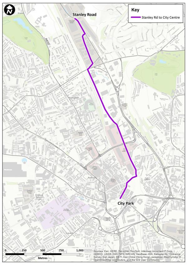
Canal Road Cycle Route
5.9 Much of the Canal Road corridor is served by National Cycle Network (NCN) Route 66, the
Greenway. The Cycle Route Study (carried out by Steer Davies Gleave in July 2014) has
considered opportunities for routes from the southern section of Canal Road into the city
centre in two parts; between City Park and the termination of the Leeds-Bradford CityConnect
route on Lower Kirkgate, and onward connections to Forster Square. The proposed route is
illustrated in Figure 5.1 below and a copy of the Cycle Route Study report is provided in
Appendix C.
Figure 5.1: Canal Road Cycle Route
May 2015 | 17Transport Study in Support of the Shipley and Canal Road Corridor AAP |
5.10 City Region funding for CityConnect2 has now been secured, which will deliver the 2.5km
extension from the Leeds-Bradford route between Forster Square Rail Station and the
Greenway on the National Cycle Network.
5.11 At the northern end of the corridor, permission has been granted for completion of a link from
NCN Route 66 to Shipley. Funding for this link has come from a combination of DfT Cycle Route
Information Fund and Shipley Hubs Money from the Local Transport Plan.
Shipley Station Car Park Improvements
5.12 The Council is proposing to provide additional parking capacity at Shipley railway station as
part of the Shipley Station Car Park Improvements scheme. This is being funded by the WY+TF
rail package. The construction of a new deck on top of the current car park is the preferred
option and this will compliment developer led proposals for the Shipley Exchange application
indicated earlier.
5.13 Improved car park access and better connections between the station and the town centre are
also proposed.
Shipley Eastern Relief Road
5.14 Although unlikely to be delivered within the timescales of this study, the potential benefits of
the proposed relief road are recognised and supported.
5.15 The key element of Connecting Airedale – Stage 4, Shipley Eastern Relief Road (SERR) will
relieve congestion in Shipley town centre by creating a bypass to the east, connecting the
A6037 Valley Road/Canal Road and A6038 Otley Road. The relief road will also provide a
second crossing of the River Aire at Shipley. Although precise details are not available, a
reduction in north-south traffic through the Fox Corner junction will allow reconfiguration of
the signal timings to the benefit of continued east-west movements. As shown in previous
chapters, east-west movements are expected to be most affected by increased demand in
future years. Funding for a more detailed study of the benefits of the SERR has been secured
and it is imperative that a route for SERR is safeguarded to enable future delivery of the
scheme.
New Schemes
Canal Road Cycle Route from Stanley Road to the City Centre – Valley Road Closure
5.16 The Cycle Route Study, describes how, between the City Centre and Stanley Road, cyclists are
routed along Valley Road between the Tesco store and Queen’s Road. Although not heavily
trafficked, this is an acknowledged rat run for cars avoiding the busy parallel section of Canal
Road, despite regular speed bumps along the route. Relatively free flowing traffic along this
section, coupled with parked cars along most of the route make conditions difficult for cyclists.
5.17 To improve conditions for cyclists it is recommended that opportunities to restrict through
traffic on this route are considered, while retaining existing on-street parking and access to
employment sites. The improvements will be taken forward through the Cycle City Ambition
Grant Programme “CityConnect 2”.
Testing of highway interventions
5.18 Schemes identified at the start of this chapter have been recognised as critical to deliver
proposed growth in the Shipley and Canal Road Corridor and, as such, will be delivered and are
May 2015 | 18Transport Study in Support of the Shipley and Canal Road Corridor AAP |
therefore included in the baseline against which additional impacts of further interventions
can be tested.
5.19 It is only the proposed Valley Road Closure intervention recommended as part of the cycling
scheme has been coded in to the SATURN model as a new scheme, and the impact of its
introduction has been assessed through the assignment of the 2030 Forecast Year demand.
5.20 For the closure test, a full description of differences in traffic flows between the tested
scheme and the 2030 Forecast Year reference case are provided in Appendix D. The findings
are summarised here.
Intervention: Valley Road Closure
5.21 Different impacts are seen to result from a closure of Valley Road to through traffic in each of
the AM and PM peaks, although in each case the impacts are constrained to the Canal Road
corridor. In the morning peak, traffic is mainly diverted to corridors west of the railway,
whereas in the evening peak the implications for increase in traffic on Canal Road would be
greater.
Benefits
5.22 The removal of through traffic from Valley Road is entirely intended to improve conditions for
cyclists connecting between the City Centre and the Greenway route.
Issues and feasibility
5.23 The model is not sufficiently detailed to assess the impacts on traffic heading to/from the
Tesco store at the southern end of Valley Road, and more detailed analysis is recommended.
Otherwise, the proposals would be relatively cheap to implement and could be timed to
coincide with the timing of further improvements to the Greenway route.
5.24 The following table provides forecast changes in two-way flows on key links in the Shipley and
Canal Road Corridor AAP area, and supplements the plots in Appendix B showing differences
in traffic flows associated with a potential closure of Valley Road to through traffic.
5.25 The basic assessment of the impacts of each of closing Valley Road to through traffic has not
identified any issues that might not have been expected given the nature and scale of the
scheme. As such, there would seem no reason why the proposed interventions could not be
introduced.
Table 5.1: Change in key link flows across between the future Baseline and the Valley Road Closure test – 2030,
AM and PM peak
AM Peak flow (2-way) PM peak flow (2-way)
Key Routes
2030 DM Closure Test 2030 DM Closure Test
Shipley and Canal Road Corridor
Canal Road, south of Queen’s Road 4900 4950 4840 5040
Valley Road, south of Queen’s Road 270 190 370 210
Manningham Lane south of Queen’s Road 1930 1970 2030 2050
Canal Road, north of Queen’s Road 3200 3190 3340 3340
Keighley Road, north of Queen’s Road 2750 2780 2740 2730
May 2015 | 19Transport Study in Support of the Shipley and Canal Road Corridor AAP |
Key Routes AM Peak flow (2-way) PM peak flow (2-way)
Otley Road, Keighley Road-Valley Road 1830 1840 1740 1730
Bingley Road, north of Otley Road 2230 2240 2600 2600
Saltaire Road, Shipley 1850 1870 1970 1970
Briggate, Shipley 2220 2220 2620 2620
Matching interventions to issues
5.26 In the previous chapters, a number of issues have been identified which will need to be
addressed if increased demand in future years is to be successfully managed.
5.27 Where possible, the interventions identified in this chapter are designed to address some of
those issues.
Intervention Issue
Committed Schemes
Requirement to provide additional capacity on Canal
Canal Road dualling Road to meet future demand. To be delivered through
WY+TF
Requirement to provide additional capacity in the
Leeds Road/Crag Road junction Canal Road corridor to meet future demand. To be
delivered through WY+TF
Requirement to provide additional right turn from
Valley Road/Otley Road junction Valley Road towards Shipley. TO be delivered by the
Shipley East developers
Proposed Schemes
National Cycle Route 66 Extension from Shipley to the Improved connections for cyclists in Shipley town
City Centre centre
Improved routes along Canal Road to encourage
Valley Road closure
continued growth in cycle use
Developer proposals for additional station parking
associated with Crag Road, Shipley Exchange Shipley railway station car park capacity. To be
development delivered through WY+TF
Shipley Station Car Park Improvements
Shipley Eastern Relief Road
Future reductions in traffic speeds in Shipley town
Options for better pedestrian/cycle connections centre associated with growth of the town
between the town centre and Shipley railway station
To ensure development sites in the corridor can be
Additional bus services
delivered sustainably
Policy considerations
5.28 Throughout the assessment of anticipated transport conditions in 2030, and the specific
implications for development sites in the City Centre and Shipley & Canal Road Corridor AAPs,
a number of assumptions have been made which will need policy support to deliver.
May 2015 | 20Transport Study in Support of the Shipley and Canal Road Corridor AAP |
Planning policy
5.29 Adequate local mitigation for each new development application should be ensured. The
Council’s should continue to enforce its policy that all new planning applications, and reserved
matters applications if appropriate, will require a detailed transport assessment and Travel
Plan to be submitted in support of the proposals.
5.30 Developers should be required to demonstrate how the impacts of development can be
mitigated through the design of the development, the provision of user friendly access to bus
networks and rail stations and to ensure that connections into key pedestrian and cycle routes
are made available.
Car and cycle parking
5.31 There is a need to support the use of low vehicular trip rates in the current assessments, and
to encourage use of the various cycling initiatives being implemented or proposed.
5.32 Parking standards for different types of development are presented in the Core Strategy. For
residential development, the standards already establish a distinction between city centre
developments and those elsewhere. Furthermore, there is an discretionary allowance for
more restrictive levels of car parking provision in the case of multi-occupancy residences.
5.33 It is worth noting that on 25th March 2015 the Secretary of State for Communities and Local
Government issued a written statement3 setting out that “Local planning authorities should
only impose local parking standards for residential and non-residential development where
there is a clear and compelling justification that it is necessary to manage their local road
network”.
5.34 The local parking standards as set out in the Core Strategy are considered justified in relation
to the predicted growth in future traffic and the need to manage the local road network, It
should be noted that these standards are designed to applied flexibly.
5.35 All developments should also offer cycle parking, as included in the standards, but further
delivery of city centre cycle parking should also be secured to provide facilities for cyclists from
surrounding areas who would like to cycle to the city centre for employment, retail or leisure
and to support growth in cycle mode share.
Non-car modes
5.36 It should be made easier and more attractive for people – particularly occupants of new
developments – to make an informed choice between using the private car or making
alternative journeys by public transport, walking or cycling.
5.37 Developers should demonstrate, through their Travel Plans, real commitment to promoting
non-car modes. In the case of public transport, and particularly bus, it is recommend that
developers are encouraged to offer more than just Travel Passes over the first few months of a
development. Section 106 contributions should be pursued towards the cost of new services,
bus priority at key junctions and better bus stops.
5.38 Developers should also ensure that all major developments are ‘PT ready’ – ie the internal
network is designed with a hierarchy of roads, designed to accommodate bus movements.
3
Written Statement HWC488 – Parking: helping local shops and preventing congestion
May 2015 | 21You can also read