The agricultural colonization of the Pomptinae Paludes: surveys in the lower Pontine plain
←
→
Page content transcription
If your browser does not render page correctly, please read the page content below
Tymon de Haas

                                     The agricultural colonization of the Pomptinae Paludes:
                                               surveys in the lower Pontine plain

Early roman colonization

         Our picture of the Roman conquest of the Italian Peninsula (roughly between the 6th and 3rd centuries
BC) is largely based on historical sources that describe Rome as the power that first came to dominate its
Latin allies and subsequently took the initiative for territorial expansion into areas inhabited by other tribes;
the founding of colonies in alien territory was an important part of this expansion strategy. The colonies,
however, were not only military strongholds, as they received considerable numbers of colonists that worked
the surrounding agri. 1 Moreover, areas further away from the colonies were assigned directly to Roman
citizens, presumably causing waves of ‘agricultural colonization’.
         From an archaeological point of view, the early phases of colonization are not well understood:
remains of the oldest occupation phases of colonies is scanty at best, as excavations and/or topographic
research have primarily uncovered remains of late Republican and Imperial date. Similarly, little is known of
the development of the agri of these colonies, as most (topographic) surveys are concerned with
monumental remains of villas and farms of later date. However, a more detailed study of earlier rural
settlement would contribute to a better understanding of the process of colonization. This paper discusses
such a detailed study of rural settlement in relation to the Roman colonization of the Pontine region.

The pontine region, the Pontine Region Project and intra-regional comparative research

        The Pontine region is located on the Tyrrhenian coast of south Lazio, ca 60 km south of Rome (fig.
1). The region consists of various landscape zones: the volcanic Alban hills and the limestone ranges of the
Lepini and Ausoni mountains delimit a large coastal plain which consists of a series of fossil marine terraces
and, further inland, a filled-up and poorly drained fossil lagoon. This is the area traditionally known as the
palude pontine.
        The Pontine region is one of the first areas into which Rome and its allies expanded: colonies were
                                              th    th
founded along the Lepini mountains in the 6 to 4 century BC and functioned as important strongholds in
the struggles with intruding mountain tribes, particularly the Volscians. A number of maritime colonies was
                     th
established in the 4 century BC and after 338 BC, with the fall of the Volscian strongholds Antium and Priv-

1
 Maritime colonies, however, contained a small colonist population; Latin and citizen colonies usually received several thousands of
colonists; see SALMON 1969.

Bollettino di Archeologia on line I 2010/ Volume speciale/ Poster Session 10                    Reg. Tribunale Roma 05.08.2010 n. 330 ISSN 2039 - 0076
www.archeologia.beniculturali.it/pages/pubblicazioni.html

                                                                                     1
T. de Haas – The agricultural colonization of the Pomptinae Paludes: surveys in the lower Pontine plain

vernum, the region was supposedly finally
‘pacified’. In this period, there may also have
been an influx of colonists as a part of the
agricultural colonization of the lower part of
the Pontine plain.
         The Groningen Institute of Archaeo-
logy (GIA) has been involved in landscape
archaeological research in the region from the
mid 1980s onwards with the Pontine Region
Project (PRP). Within this long-term research
project, intensive field surveys are employed
to study the settlement history of the region,
with Roman colonization as one of its main
research themes2.
         The study presented here represents
some of the most recent work carried out
within the PRP and uses an intra-regional
comparative perspective to better understand
how settlement and land use developed in the
light of Roman colonization3. For this, surveys                                Fig. 1 - The Pontine region with main landscape units, Roman towns
                                                                               and the via Appia.
are carried out in three sample areas situated
in three major landscape zones: the coastal
landscape around present-day Nettuno; the
edge of the Lepini mountains surrounding
Norma; and the lower Pontine plain west of
Pontinia (fig. 2). In historical terms, the first
two areas are part of the agri of Satricum and
the maritime colony Antium and of the Latin
colony Norba. The third area is strongly linked
to the via Appia and it may have been part of
the area where agricultural colonization took
place. The settlement history of each of these
sample areas is studied in relation to the local
landscape, the adjacent colonies and major
infrastructure. Local settlement histories are
subsequently placed in their regional and
interregional context. In the following, I will
focus on the research in the third of the three
case study areas, the lower Pontine plain.
                                                                               Fig. 2 - Location of the three study areas in relation to Roman colonies
                                                                               and centuriated areas (crosshatches).

2
  In its initial phases, the PRP focused on protohistoric and Roman central settlements and their surroundings along the Lepini
mountains and in the volcanic area north of Cisterna di Latina (ATTEMA 1993). In the mid 1990s, the project widened its geographical
scope to the Alban hills and the Sacco valley with surveys around the colonies Setia, Lanuvium and Signia (A TTEMA and VAN LEUSEN
2004). These surveys used more standardized methods that are suited for comparative analysis. Surveys with similar methodologies
continued on the edge of the Lepini mountains near ancient Norba (VAN LEUSEN 1998) and in the catchment of Satricum. In the late
1990s, the project turned to the coastal areas with intensive surveys near Lake Fogliano and surveys as well as site mapping projects
east of Nettuno and in the lower Astura valley (A TTEMA ET ALII 2002; 2003).
3
  See also DE HAAS 2008.

Bollettino di Archeologia on line I 2010/ Volume speciale/ Poster Session 10                                       Reg. Tribunale Roma 05.08.2010 n. 330 ISSN 2039 - 0076
www.archeologia.beniculturali.it/pages/pubblicazioni.html

                                                                                   2
XVII International Congress of Classical Archaeology, Roma 22-26 Sept. 2008
                                                                                               Session: Landscape Archaeology / Archeologia del Paesaggio

Agricultural colonization of the lower pontine plain or pomptinae paludes?

          The Pontine plain consists of
two distinct parts. A system of marine
terraces of 6 to 8 km wide stretches out
along the Tyrrhenian coast, while the
area further inland has long been a lagoon
that was cut off from the sea by the
marine terraces; this lagoon has in the
course of time been filled with peaty and
clayey sediments4. Because it is situated
at a lower altitude than the marine ter-
races, water cannot easily flow off to the
sea, resulting in wet, marshy conditions,
endemic malaria and in general it is
thought to have had a very limited land
                5
use potential . In antiquity, this lower
part of the Pontine plain area was re-
ferred to as the Pomptinae Paludes and
the historical sources describe various
attempts at draining them6. However,
the assignment of agricultural plots to
colonists of the tribus Pomptina (created       Fig. 3 - Map of the palude pontine made for a drainage project proposed by
in 358 BC) and Oufentina (318 BC)7              Emerico Bolognini (BOLOGNINI 1759).
indicates that the area was at least par-
tly fit for agricultural use. The construction of the via Appia and the Decennovium canal also point to the
successful drainage and exploitation of the area8. In later periods too attempts were made at draining the
palude pontine (fig. 3)9. The most recent and successful of these projects, the bonifica integrale, took place
in the 1930s and transformed the marsh into an intensively cultivated area with regular plots, an ex novo
established infrastructure with towns, villages, and farms that were settled by carefully selected colonist
families10.
          The perception of the lower Pontine plain as marshy and unsuited for settlement and agriculture
perhaps is one of the reasons it has received relatively little attention from archaeologists11. However, traces
of a centuriation grid may point to large scale reclamation and agricultural colonization of almost the entire
lower plain (see fig. 2). The evidence for this grid consists of a number of east-west running Roman roads as
well as parcelling traces with a similar orientation identified on aerial photographs and maps made before the
                    12                                                              2
bonifica integrale . The grid would have covered an area of some 230 km , divided into blocks of 10 by 10
actus. Cancellieri has proposed a date before the construction of the via Appia (312 BC), as it would
otherwise have followed the orientation of this road13. According to her, the grid was laid out to distribute agri-

4
  KAMERMANS 1991, 23/28.
5
  BIANCHINI 1964; S ALLARES 2002.
6                                                    nd                         st
   For example, by Cornelius Cethegus in the 2 century BC, and in the 1 century BC by Caesar; for an overview of historical
references to the Pomptinae Paludes, see HOFFMAN 1956.
7
  Dates after CORNELL 1995, 382–83.
8
   CANCELLIERI 1986; COARELLI 1990. In fact, the term Pomptinae Paludes may not have been coined before the Imperial period; see
TRAINA 1990.
9
  For an overview, see LINOLI 2005.
10
   For an extensive description of this project, see KOEPPEN 1941; see also LINOLI 2005.
11
   With the exception of the via Appia and related monuments like bridges, milestones, monumental tombs: C ANCELLIERI 1975; QUILICI
1989; BRUCKNER 1995; LILLI 1996; SEVERINI 200; see also papers in Archeologia Laziale X (1990).
12
   CANCELLIERI 1985; 1990.
13
   CANCELLIERI 1990, 66–70.

Bollettino di Archeologia on line I 2010/ Volume speciale/ Poster Session 10                                      Reg. Tribunale Roma 05.08.2010 n. 330 ISSN 2039 - 0076
www.archeologia.beniculturali.it/pages/pubblicazioni.html

                                                                                3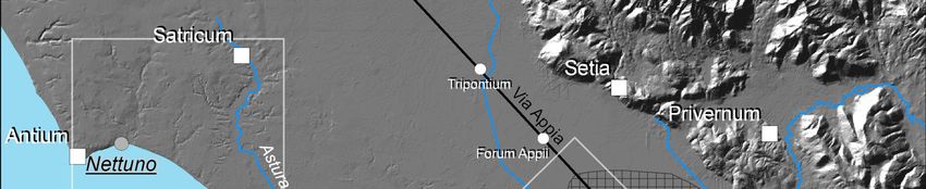
T. de Haas – The agricultural colonization of the Pomptinae Paludes: surveys in the lower Pontine plain

                                                                                                   cultural plots to members of the
                                                                                                   tribus Oufentina in 318 BC. Howe-
                                                                                                   ver, there are also other historical
                                                                                                   events to which the centuriation
                                                                                                                     14
                                                                                                   could be related      and archaeo-
                                                                                                   logical evidence to confirm the pro-
                                                                                                   posed date and historical context
                                                                                                         15
                                                                                                   lacks .

                                                                                                   Surveys in the pomptinae paludes

                                                                                        With this background, inten-
                                                                                sive surveys were undertaken,
                                                                                aiming to map rural settlement in a
                                                                                representative part of the Pomptinae
                                                                                Paludes and to interpret its settle-
                                                                                ment history in the light of the sup-
                                                                                posed agricultural colonization and,
 Fig. 4 - The survey transect west of present-day Pontinia with surveyed units. more specifically, to see whether
                                                                                there is archaeological evidence in
                                                                                support of a late 4th century BC date
for the centuriation. As the lower Pontine plain is very large and only limited time (and funding) was
available, fieldwork was planned in a restricted area; a northeast-southwest oriented transect of ca 1.5 x 3.5
km west of present-day Pontinia (fig. 4). The transect is enclosed by the migliara 45 and migliara 46 roads,
running from the via Appia to the edge of the marine terraces; the collettore delle acque medie (a canal)
delimits the survey area here. Nowadays, cereals, corn and vegetables are grown in the area, although
some fields are permanently fallow or used as pastures.

Methodology

        The method used during the survey of this transect entails intensive and detailed coverage by
dividing arable fields into regular units, by default of 50 x 50 m16. Each unit is traversed by five walkers
evenly spaced at 10 m; all artefacts in their transect are collected. Supposing walkers cover a strip 2 m wide,
this means that a 20% sample of the surface assemblage of each unit is collected. If artefact concentrations
are encountered, additional samples are taken. Fields, units and sites are mapped using a handheld
computer (PDA) with ArcPAD software connected to a GPS receiver. Notes on survey circumstances, field
conditions and finds are kept in a field book.
        Daily finds and data processing was aimed at preparing the data for easy preliminary analysis. Finds
were washed, dried and subsequently classified, counted and weighed. The resulting data were stored in an

14
   On the one hand, in other areas centuriation grids that do not follow the orientation of major roads postdate such roads; this implies
that the grid does not necessarily predate the construction of the via Appia. This means that the grid could also be connected to later
drainage projects. On the other hand, there are also other historical events earlier in the fourth century BC that could relate to land
division schemes. For a recent overview of issues related to centuriation grids and their dating, see PELGROM 2008.
15                                                                                     th   st
   A few sites along the via Appia south of Forum Appii have been dated to the 4 - 1 century BC and Forum Appii was certainly
                      th       rd
occupied in the late 4 /early 3 century BC; see BRUCKNER 1990, 195, 218–19. Several transects of the Agro Pontino Survey also run
through the area, but these data have not been analyzed in detail for the Roman period; see KOOT 1991; HOLSTROM ET ALII 2004.
Cancellieri has also mapped rural settlements in the Amaseno valley, but it is unclear if these would still fall within the centuriated area;
see CANCELLIERI 1987.
16
   See also V AN LEUSEN 2002.

Bollettino di Archeologia on line I 2010/ Volume speciale/ Poster Session 10                              Reg. Tribunale Roma 05.08.2010 n. 330 ISSN 2039 - 0076
www.archeologia.beniculturali.it/pages/pubblicazioni.html

                                                                               4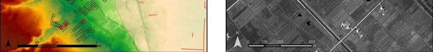
XVII International Congress of Classical Archaeology, Roma 22-26 Sept. 2008
                                                                                               Session: Landscape Archaeology / Archeologia del Paesaggio

                  Fig. 5 - Distribution of artefacts and sites over the transect; colours indicating visibility estimates.

Access database together with the field information describing survey circumstances and the samples for
each unit. This database is connected to map layers in a desktop GIS that provide distribution maps that
were updated every day. Diagnostic artefacts from sites were selected for drawing and describing and
provide the basis for a more refined dating of the sites.

Summary results

          In total, 848 units with a total surface of ca 1.8 sq.km, ca 30% of the transect, were surveyed (figs. 4
and 5). Most units (66.8%) were (deep-) ploughed, 29.4 % were harrowed and only 4.0 % were located on
fallow terrain. In general, ground visibility was good: in only 3.3 % of the blocks the visibility was described
as poor, in 46.5% of the blocks as medium, in 45.0 % as good and in 5.2 % as very good. In general, fields
to the north had a better visibility than those to the south: near the via Appia, some fields with very good
visibility occur and most fields have good visibility; further to the south a few fields had bad visibility, whereas
most had a medium to good visibility.
          Artefacts were collected from 385 blocks (fig. 5), and 24 additional grab samples and diagnostic
samples were collected from various sites. In total, 6733 artefacts with a total weight of ca 208 kg were
collected. Lithics and handmade pottery occur in modest quantities; the bulk of the finds dates to the Roman
period. Both in number and weight, tiles and pottery form the most abundant find categories. Although
concentrations occur to the south and west, finds densities are highest in the northern part of the transect.

Bollettino di Archeologia on line I 2010/ Volume speciale/ Poster Session 10                                      Reg. Tribunale Roma 05.08.2010 n. 330 ISSN 2039 - 0076
www.archeologia.beniculturali.it/pages/pubblicazioni.html

                                                                                5
T. de Haas – The agricultural colonization of the Pomptinae Paludes: surveys in the lower Pontine plain

                                                                                        These were probably the areas
                                                                              where settlement and (intensive) agriculture
                                                                              concentrated. Most fields in the central part
                                                                              yielded very few or no finds, perhaps indi-
                                                                              cating that these areas were less intensively
                                                                                                            17
                                                                              used, for example as pasture .
                                                                                        If we break down the distribution
                                                                              map into more detailed period maps, there
                                                                              are some significant patterns18. Of the hand-
                                                                              made pottery (impasto) only a minor group is
                                                                              probably of protohistoric date (fig. 6, brown
                                                                              dots). These finds in most cases occur on
                                                                              Roman sites and may indicate that these
                                                                              already had protohistoric predecessors. A
                                                                              few pieces in relatively “empty” areas per-
                                                                              haps indicate that more protohistoric sites
                                                                              may be found using even more intensive and
                                                                              targeted surveys. Most of the handmade
Fig. 6 - Distribution of protohistoric (green) and Archaic/post-Archaic (red) pottery, however, consists of augite tempe-
handmade pottery.                                                             red ceramics that are often considered Ar-
                                                                              chaic (fig. 6, red dots). However, as they
                                                                              occur in low numbers and they may also
                                                                              occur in post-Archaic contexts, they are here
                                                                              not taken as conclusive evidence for Archaic
                                                                              settlement.
                                                                                       The majority of the Roman finds can-
                                                                              not be dated with much precision, but the
                                                                              frequency and distribution of fine wares (fig.
                                                                              7) indicates that the bulk probably dates to
                                                                              the Republican period, as black glazed is by
                                                                              far the most common fine ware. Terra
                                                                              sigillata (mainly 1st century AD) and African
                                                                              Red Slip ware (mainly late 1st century – mid
                                                                              3rd century AD) occur in lower numbers and
                                                                              fewer locations, notably along the via Appia
                                                                              and on the southwestern edge of the tran-
                                                                              sect.
                                                                                       20 Sites were discovered and/or re-
Fig. 7 - Distribution of Roman fine wares (black glazed ware, terra sigillata                                    19
                                                                              visited during the survey (table 1) . Most of
and African red slip wares); in the background distribution of all artefacts.
                                                                              these are located to the northeast, near the
via Appia; five are clearly aligned along this road, whereas the others perhaps point to the existence of a
secondary road at right angles to the via Appia. Few (and only small) sites are located in the central part of
the transect, but there is a number of sites to the southwest.

17
   There is some correlation between the find densities and visibility; however, in my view this cannot account for the large difference in
find (and site) density. This leaves aside the fact that there are still considerable areas in the transect not surveyed, where there may be
additional sites.
18
   The distribution maps show the actual finds and have not been corrected for coverage or variations in visibility.
19
   16 sites were discovered during the block survey, two sites were discovered during targeted visits to possible site locations (see
below). Two sites already mapped during the Agro Pontino Survey were revisited. Several more sites are known in the area, but these
could not be studied for various reasons.

Bollettino di Archeologia on line I 2010/ Volume speciale/ Poster Session 10                              Reg. Tribunale Roma 05.08.2010 n. 330 ISSN 2039 - 0076
www.archeologia.beniculturali.it/pages/pubblicazioni.html

                                                                               6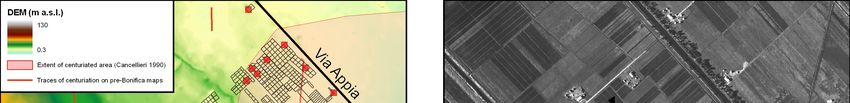
XVII International Congress of Classical Archaeology, Roma 22-26 Sept. 2008
                                                                                               Session: Landscape Archaeology / Archeologia del Paesaggio

         The sites vary in size between 170
and 6250 m2 with three distinct size groups:
four sites are smaller than 250 m2, thirteen
sites are between 1000 and 3000 m2, while
two sites are larger than 5000 m2 20. One of
these consists of at least two separate
nuclei. The artefact assemblages also show
significant differences: the small sites yield
few artefacts, mostly tile, storage pottery and
coarse wares. The medium-size sites con-
tain a wider range of artefacts including tile,
brick, cement, cooking wares, table wares,
and storage and transport vessels; a few
also had tesserae, one may contain an a
capuccina tomb, while on one we collected
dolium wasters and kiln debris. One of the
two large sites shows evidence for more
elaborate architecture (wall plaster, marble);
                                                   Fig. 8 - Distribution of site types over the survey area.
the other had relatively large amounts of
storage and transport pottery.
         In combination, the size estimates and the assemblages point at a site typology consisting of at least
three classes (fig. 8): the large site with evidence for elaborate architecture probably represents a villa; the
other large site may be a large storage facility, perhaps connected to a farm. The medium-size sites probably
represent farms (one with connected burials), although one may be a pottery workshop producing dolia. The
small sites probably represent more ephemeral structures, perhaps sheds or shelters.
         Although not all diagnostic artefacts have been analyzed, a preliminary chronology of the sites can
be presented here (fig. 9). Coarse ware shapes (olle, teglie) that are well known from 5th to 3rd century BC
stratigraphic contexts at the settlement of Satricum (located some 20 km to the west; see fig. 1), occur on 17
sites21. A 3rd century date for at least four sites is indicated by early black glazed wares of the atelier des
petites estampilles; two more sites have 4th or 3rd century BC coarse wares. Most diagnostic ceramics date
from the 3rd century BC to the 1st century AD, with a peak in the 2nd and 1st century BC. Three sites contain
coarse wares and African Red Slip wares that date to the 2nd and/or 3rd century AD. The villa has also
yielded late 4th to 6th century AD material.

Reconstructing the landscape prior to the bonifica integrale

        The present-day appearance of the lower Pontine plain with its infrastructure and parcelling system
goes back to the land reclamations of the 1930s. For a better understanding of the archaeological remains
recorded during the survey, it is of great importance to assess the changes in the landscape brought about
by the bonifica integrale. Fortunately, prior to the interventions, the entire Pontine plain was mapped at a
scale of 1:5000. These maps contain detailed elevation data, but also information on land use, water sources
and previous parcelling and drainage systems. In digitized form they provide a very important background against

20
   The contour of each site was recorded with the PDA; no fixed finds density was used for this, as such densities largely depend on
visibility circumstances. Although post-depositional processes may have caused dispersion of finds, the variations in size in my view are
useful indicators for the interpretation of sites.
21
   Such coarse wares occur both in the post-Archaic necropolis and in votive deposit 2; see G NADE 1992 and BOUMA 1996 respectively.

Bollettino di Archeologia on line I 2010/ Volume speciale/ Poster Session 10                                      Reg. Tribunale Roma 05.08.2010 n. 330 ISSN 2039 - 0076
www.archeologia.beniculturali.it/pages/pubblicazioni.html

                                                                                7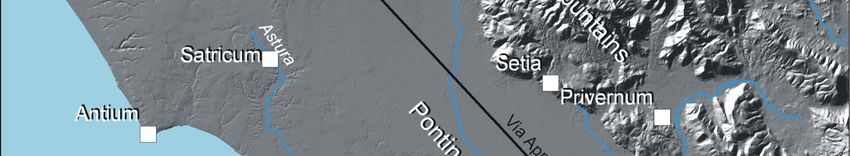
T. de Haas – The agricultural colonization of the Pomptinae Paludes: surveys in the lower Pontine plain

                Fig. 9 - Diachronic changes in settlement.

Bollettino di Archeologia on line I 2010/ Volume speciale/ Poster Session 10                              Reg. Tribunale Roma 05.08.2010 n. 330 ISSN 2039 - 0076
www.archeologia.beniculturali.it/pages/pubblicazioni.html

                                                                               8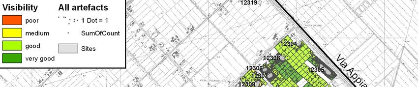
XVII International Congress of Classical Archaeology, Roma 22-26 Sept. 2008
                                                                                               Session: Landscape Archaeology / Archeologia del Paesaggio

                Fig. 10 - The survey area and sites on the DEM. Pink circles indicate some of the ‘bumps’ that represent sites
                (DEM courtesy H. Feiken).

which to analyze the archaeological data. Figure 10 displays the survey area and sites on a digital elevation
model (DEM) that was created on the basis of these maps22.

Survey results in the light of the DEM

         The DEM shows that the northeastern part of the transect, where most sites are located, is situated
at ca 4.5 to 5 m a.s.l. (pale to light green areas). From here the terrain gradually rises to the southwest,
where a steeper slope (dark green and yellow areas, 8-20 m a.s.l.) represents the transition from the lower
plain to the higher marine terraces (red areas, >20 m a.s.l.). A number of sites are situated on this transition,
two on the south bank of a stream that enters the lower plain. This transition is also the area in which
settlement continued after the lower lying parts were abandoned in the 1st and 2nd centuries AD.
         Several other aspects of the DEM catch the eye. First of all, a linear elevation runs through the
transect from northwest to southeast. This elevation may represent a former canal that was led through this
area as part of a practice called colmatage, intended to improve soil conditions by flooding the surrounding
terrain. After such floods, sediments present in the water would remain and ground level would be raised, thus

22
  All elevation points and contours as well as all springs, canals and ditches from map sheets I8-10, K8-10 and L8-10 were digitized.
The DEM was created on the basis of the elevation contours and points using the Topo to Raster tool available in ArcGIS.

Bollettino di Archeologia on line I 2010/ Volume speciale/ Poster Session 10                                      Reg. Tribunale Roma 05.08.2010 n. 330 ISSN 2039 - 0076
www.archeologia.beniculturali.it/pages/pubblicazioni.html

                                                                                9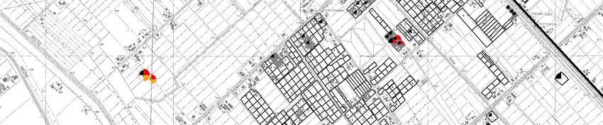
T. de Haas – The agricultural colonization of the Pomptinae Paludes: surveys in the lower Pontine plain

Fig. 11a/b - Traces of the centuriation grid on (a) the pre-bonifica DEM and on (b) a detail of the northeast part of the transect on an
aerial photograph made in 1936 (courtesy IGM, Florence).

improving environmental conditions23. Recent research may show that this canal was part of reclamations of
the medieval period24.
         Of interest too are the ‘bumps’, small areas that rise up to 1.5 m above their surroundings, visible in
the DEM in various places. Both the regular survey and targeted visits to such bumps show that some of
these contain archaeological remains. In some cases the bump itself may consist of archaeological debris
layers, but a coring on site 12303 (fig. 5) showed that soil was also brought in from elsewhere before this site
was constructed. Perhaps this was done in order to improve the run-off of water, or perhaps even to reduce
the risk of flooding. This site contains ceramics that date from the 1st century BC onwards, perhaps also from
the 3rd/2nd century BC. This indicates that at least from the 1st century BC onwards there were problems with
drainage even in higher areas.

Traces of a Roman centuriation grid?

          Although the centuriation grid as published by Cancellieri runs only halfway into the survey transect,
there are also traces on the pre-bonifica maps to the west (fig. 11); Additional traces within the transect were
also observed on aerial photographs of 1936; Taken together, the maps and photographs indicate that the
centuriation grid probably extended further northwest than previously thought. The exact boundaries of the
grid will have to be established by analysis of additional map sheets and aerial photographs.

Concluding remarks

        The archaeological evidence presented here shows that the surveyed part of the Pomptinae Paludes
was intensively used in Roman times. The distribution of sites and off-site artefacts indicates that in the
Republican period large parts of the area were cultivated from dispersed farms. Most of these were founded
sometime between the 5th and 3rd centuries BC. From the early Imperial period onwards their number
                                                                       nd    rd
declines strongly, with only a few farms and a villa inhabited in the 2 and 3 centuries AD. Perhaps these
now exploited larger landholdings and/or had shifted to more extensive forms of land use.

23
     Cf. SEVINK ET ALII 1991, 41; Sevink pers. comm.
24
     Sediments in this canal have been radiocarbon dated within GIA’s Hidden Landscapes project; Feiken pers. comm.

Bollettino di Archeologia on line I 2010/ Volume speciale/ Poster Session 10                              Reg. Tribunale Roma 05.08.2010 n. 330 ISSN 2039 - 0076
www.archeologia.beniculturali.it/pages/pubblicazioni.html

                                                                               10
XVII International Congress of Classical Archaeology, Roma 22-26 Sept. 2008
Session: Landscape Archaeology / Archeologia del Paesaggio
The study of pre-bonifica maps contributes to our understanding of the archaeological remains
discovered during the survey: not only do they help identify potential site locations (visible as ‘bumps’ on
these maps), they also prove useful in explaining changes in settlement. Whereas in the Republican period
sites occur both in relatively low and high parts, settlement in the 1st century AD clearly concentrated along
the via Appia and on higher grounds to the southwest. After the 1st century AD sites occur on these higher
grounds only. Even on these relatively well drained higher grounds there may have been a need to build on
artificial elevations – small ‘dwelling mounds’. It thus seems likely that the cause for the abandonment of the
lower parts must be sought in deteriorating drainage conditions.
The pre-bonifica maps and aerial photographs also provide additional evidence for the existence of a
centuriation grid that has tentatively been linked to a late 4th century agricultural colonization of the lower
Pontine plain. The field survey presented in this paper shows that on archaeological grounds it is possible
that the grid was part of an early agricultural colonization of the area. However, as the peak of settlement lies
rd st
in the 3 to 1 centuries BC, it is also possible that the centuriation is connected to a later restructuring of an
already settled area.
It should be kept in mind that the survey covers a relatively small area on the northern fringes of the
centuriation; the area further to the southeast lies even lower and hydrological conditions may have been
even worse. We could thus also imagine an alternative scenario, in which settlement had expanded up to the
very edges of the Pomptinae Paludes in the 5th and 4th century BC, which were reclaimed by laying out a
centuriation grid and cultivated by new farmers in the 3rd and/or 2nd century BC. This scenario is of course
highly speculative, and obviously more research is needed to test various possible scenarios. On the one
hand, revisits to sites in the transect could help in providing more detailed dating evidence for sites in this
part of the centuriation. On the other hand, systematic surveys should be expanded into adjacent areas in
order to evaluate whether other parts of the lower Pontine plain were also settled in the 5th to 3rd centuries
BC or later. In my view this is the only way in which we can date the centuriation grid with more certainty and
thus understand better the historical context of the agricultural colonization of the Pomptinae Paludes25.
Table 1.
SiteID Survey Sampling Size Finds Date Interpretation
method method
2
12301 Block Standard, 1370 m Impasto (plain and red augite); tile (ao Possibly Protohistoric Farm/tomb(s)
th th
survey grab and three refittable large tiles); amphora; and 6 -4 century BC;
rd
diagnostic dolium; coarse ware; depurated ware; probably 3 century BC
st
samples terra sigillata?; glass flask; Iron nail; – 1 century AD;
nd
grinding stone possibly 2 century AD
2 th nd
12303 Block Standard and 2100 m Impasto (red augite); tile; opus Possibly 5 -2 century Farm
st
survey diagnostic spicatum brick; cement; amphora; BC; certainly 1 century
rd
samples coarse ware; depurated ware; black BC – 3 century AD
glazed; terra sigillata; African red slip
ware; vessel glass; Iron nail
2 th st
12304 Block Standard 1470 m Impasto (red augite); tile; amphora; Possibly 5 – 1 century Farm?
survey sample coarse ware; depurated ware; black BC
glazed; possibly bronze object
2 th rd
12305 Block Standard, 5600 m Impasto (red augite); tile; opus Possibly 5 – 3 century Farm/storage
nd
survey grab and spicatum brick; dolium (ao red augite) BC; certainly 2 century area?
nd
diagnostic amphora; coarse ware; depurated BC – 2 century AD
samples ware; black glazed; terra sigillata; Iron
nail; possibly slags
2 th
12306 Block Standard 1630 m Impasto (red augite); tile; dolium (red Possibly 5 century BC; Farm
th nd
survey sample augite); amphora; coarse ware; certainly 4 – 2 century
st
depurated ware; black glazed (ao BC; possibly 1 century
nd
petites estampilles) BC – 2 century AD
25
Surveys have been undertaken in these areas by Margherita Cancellieri and her students, but these have not yet been published.
Bollettino di Archeologia on line I 2010/ Volume speciale/ Poster Session 10 Reg. Tribunale Roma 05.08.2010 n. 330 ISSN 2039 - 0076
www.archeologia.beniculturali.it/pages/pubblicazioni.html
11T. de Haas – The agricultural colonization of the Pomptinae Paludes: surveys in the lower Pontine plain
2 th th
12307 Block Standard 2460 m Impasto (red augite); cement; tile; Possibly 5 /4 century; Farm
th
survey sample dolium (red augite); amphora; coarse certainly late 4 century
st
ware; depurated ware; black glazed BC – 1 century AD;
nd
(ao petites estampilles); Iron nails; possibly 2 century AD
loom weight
2 th th
12308 Block Standard 2640 m Impasto (red augite); tile; dolium (ao Possibly 5 /4 century; Farm
th st
survey sample red augite); amphora; coarse ware; certainly late 4 – 1
st
depurated ware; black glazed (ao century BC; possibly1 -
nd
petites estampilles); flat basalt stone 2 century AD
2 th st
12309 Block Standard 2840 m Impasto (red augite); tile; opus Possibly 5 – 1 century Farm
survey sample spicatum brick; dolium (ao red BC
augite); amphora; coarse ware;
depurated ware
2 th th
12310 Block Standard and 2350 m Impasto (red augite); tile; dolium; Possibly 6 – 4 century Farm
th
survey diagnostic amphora; coarse ware; depurated BC; certainly late 4
st
samples ware; black glazed (ao petites century BC – 1 century
nd
estampilles); terra sigillata; vessel AD; possibly 2 century
glass AD
2
12311 Block Standard 220 m Impasto (red augite); tile; amphora; Possibly 5th – 3rd Small scatter
survey sample coarse ware; depurated ware; black century BC
glazed
2 th rd
12312 Block Standard 210 m Impasto (red augite); tile; dolium; Possibly 5 – 3 century Small scatter
survey sample coarse ware; depurated ware BC?
2 th rd
12313 Block Standard 240 m Impasto (plain and red augite); tile; Possibly 6 – 3 century Small scatter
survey sample dolium (red augite); coarse ware BC
2
12314 Block Standard 170 m Tile; coarse ware; depurated ware ? Small scatter
survey sample
2 th th
12315 Block Standard and 1920 m Impasto (red augite); tile; dolium (ao Possibly 5 /4 century Farm
rd
survey diagnostic red augite); amphora; coarse ware; BC; certainly 3 century
st
samples depurated ware; black glazed BC – 1 century AD;
nd
possibly 2 century AD
2 th th
12316 Site Grab and 6250 m Tile; brick (ao suspensurae?); painted Possibly 5 /4 century Villa
rd
(re)visit diagnostic (two wall plaster; green marble slab; BC; certainly 3 century
rd
samples cores) amphora; dolium; coarse ware; BC – mid 3 century AD;
th
depurated ware; black glazed; terra possibly second half 4
th
sigillata; ARSW; vessel glass; oil – early 7 century AD
lamp; Iron nail; slag; glass water?
2
12317 Block Standard 1240 m Tile; dolium (ao red augite); amphora; Possibly 4th-start 3rd Farm/pottery
survey sample coarse ware; depurated ware; dolium century BC ? workshop
wasters; slags
2 th th
12318 Block Standard and 1750 m Tile; dolium; amphora; coarse ware; Possibly 5 /4 century Farm
rd st
survey grab samples depurated ware; black glazed BC; certainly 3 -1
century BC; possibly first
st
half 1 century AD
2 rd st
12319 Site Diagnostic 1710 m Impasto (red augite); tile; tesserae; Possibly 3 -1 century Farm
st
(re)visit samples dolium (ao red augite); amphora; BC; certainly 1 century
coarse ware; black glazed; terra AD?
sigilata
th st
13441 Site Diagnostic Unclear Impasto (plain and red augite); tile; Possibly 6 – 1 century Farm?
(re)visit samples amphora coarse ware; depurated BC
ware; black glazed
2 th st
13443 Site Diagnostic 1200 m Impasto (red augite); cement; tile; Possibly 6 – 1 century Farm
(re)visit samples brick; tesserae; dolium; amphora; BC
coarse ware; depurated ware; black
glazed
Acknowledgements
I would like to thank the Soprintendenza per I Beni Archeologici del Lazio, and especially N. Cassieri for permission to
undertake the research. I also express my gratitude to Donatella Baldacchino, Margherita Carrucci, Dagmar Ewolds,
Wob Jansen, Rogier Kalkers, Arnaud Maurer, Sanne van Poppel, Leontien Spoelstra, Sander Tiebackx, Gijs Tol and
Bollettino di Archeologia on line I 2010/ Volume speciale/ Poster Session 10 Reg. Tribunale Roma 05.08.2010 n. 330 ISSN 2039 - 0076
www.archeologia.beniculturali.it/pages/pubblicazioni.html
12XVII International Congress of Classical Archaeology, Roma 22-26 Sept. 2008
Session: Landscape Archaeology / Archeologia del Paesaggio
Christina Williamson for their participation and enthousiasm in the fieldwork and ceramic studies. Carmela Anastasia
provided valuable logistic support. I also thank Peter Attema and Martijn van Leusen for their comments on an earlier
version of this paper.
Tymon de Haas
University of Groningen
Groningen Institute of Archaeology
Postraat 6
9712 ER Groningen
the Netherlands
E-mail: t.c.a.de.haas@rug.nl
Bibliography
ATTEMA P., 1993. An archaeological survey in the Pontine Region. A contribution to the settlement history of
south Lazio 900 - 100 BC. Thesis, Ph.D. Groningen: Rijksuniversiteit Groningen.
ATTEMA P., VAN JOOLEN E. and VAN LEUSEN M., 2002. A marginal landscape: field work on the beach ridge
complex near Fogliano (South Lazio). Palaeohistoria, 41/42, 149–162.
ATTEMA P., DE HAAS T. and NIJBOER A., 2003. The Astura project, interim report of the 2001 and 2002
campaigns of the Groningen Institute of Archaeology along the coast between Nettuno and Torre
Astura (Lazio, Italy). BABesch, 78, 107–140.
ATTEMA P. and VAN LEUSEN M., 2004. The early Roman colonization of South Lazio; a survey of three
landscapes. In P. ATTEMA (ed), Centralization, early urbanization and colonization in first millennium
BC Italy and Greece. part 1: Italy. Leuven, 157–195.
BIANCHINI A., 1964. La malaria e la sua incidenza nella storia e nell'economia della regione pontina. Latina.
BOLOGNINI E., 1759. Memorie dell'antico, e presente stato delle paludi pontine rimedi, e mezzi per diseccarle
a publico, e privato vantaggio. Roma.
BOUMA J., 1996. Religio Votiva: The archaeology of latial votive religion. The 5th – 3rd century BC votive
deposit south west of the main temple at 'Satricum' Borgo le Ferriere. Thesis, Ph.D. Groningen:
Rijksuniversiteit Groningen.
BRUCKNER E., 1995. Forum Appi. In Tra Lazio e Campania. Ricerche di Storia e di Topografia antica. Napoli,
189–221.
CANCELLIERI M., 1975. un sepolcro romano a Mesa. Bollettino dell'Istituto di Storia e di Arte del Lazio
Meridionale, XVII-2, 5–20.
CANCELLIERI M., 1985. Pianura Pontina. In R. BUSSI and V. VANDELLI (eds), Misurare la terra: centuriazione e
coloni nel mondo romano. Città, agricoltura, commercio: materiali da Roma e dal suburbio. Modena,
44–48.
CANCELLIERI M., 1986. Le vie d'acqua dell'area pontina. Archeologia Laziale, VII, 143–156.
CANCELLIERI M., 1987. La media e bassa valle dell'Amaseno, la via Appia e Terracina: materiali per una carta
archeologica. Bollettino dell'Istituto di Storia e di Arte del Lazio Meridionale, XII, 41–104.
CANCELLIERI M., 1990. Il territorio Pontino e la Via Appia. Archeologia Laziale, X, 61–72.
COARELLI F., 1990. Mutamenti economici e sociali nella valle pontina tra media e tarda repubblica. In M.
CHERCHI (ed), La valle pontina nell'antichita. Atti del convegno. Roma, 51–56.
CORNELL T., 1995. The beginnings of Rome: Italy and Rome from the Bronze Age to the Punic Wars (c. 1000
- 264 BC). London.
Bollettino di Archeologia on line I 2010/ Volume speciale/ Poster Session 10 Reg. Tribunale Roma 05.08.2010 n. 330 ISSN 2039 - 0076
www.archeologia.beniculturali.it/pages/pubblicazioni.html
13T. de Haas – The agricultural colonization of the Pomptinae Paludes: surveys in the lower Pontine plain
DE HAAS T., 2008. Comparing settlement histories in the Pontine Region (southern Lazio, central Italy):
surveys in the coastal landscape near Nettuno. Digressus, 8, 1–32.
GNADE M., 1992. The southwest necropolis of Satricum. Excavations 1981 - 1986. Amsterdam.
HOFMANN M., 1956. Pomptinae Paludes. In Paulys Realencyclopädie der classischen Altertumswissenschaft
Suppl. VIII, 1135–1183.
HOLSTROM S., VOORRIPS A. and KAMERMANS H., 2004. The Agro Pontino Archaeological Survey [cdRom].
Leiden.
KAMERMANS H. 1991. Faulted land: the geology of the Agro Pontino. In A. VOORRIPS, S. LOVING and H.
KAMERMANS (eds), The Agro Pontino Survey Project. Amsterdam, 21–30.
KOEPPEN D., 1941. Der Agro Pontino Romano. Eine moderne Kulturlandschaft. Kiel.
KOOT C., 1991. The analysis of the ceramics of the Agro Pontino survey. In A. VOORRIPS, S. LOVING and H.
KAMERMANS (eds), The Agro Pontino Survey Project. Amsterdam, 117–131.
LILLI M., 1996. Ponte Diritto o piatto sulla Via Appia: dati dalla documentazione archivistica. In L. QUILICI and
S. QUILICI–GIGLI (eds), Strade romane ponti e viadotti. Roma, 41–44.
LINOLI A., 2005. Twenty-six centuries of reclamation & agricultural improvement on the Pontine marshes. In
Integrated land and water resources management in history. Norderstedt, 27–55.
PELGROM J., 2008. Settlement organization and land distribution in Latin colonies before the second Punic
War. In L. DE LIGT and S. NORTHWOOD (eds), People, Land, and Politics. Demographic Developments
and the Transformation of Roman Italy, 300 BC-AD 14. Leiden, 317–356.
QUILICI L., 1989. La Via Appia dalla Pianura Pontina a Brindisi. Roma.
SALLARES R., 2002. Malaria and Rome, A history of malaria in ancient Italy. Oxford.
SALMON E., 1969. Roman colonization under the Republic. London.
SEVERINI F., 2001. Antiche strade Lazio - Via Appia II. Milano.
SEVINK J., DUIVENVOORDEN J. and KAMERMANS H., 1991. The soils of the Agro Pontino. In A. VOORRIPS, S.
LOVING and H. KAMERMANS (eds), The Agro Pontino Survey Project. Amsterdam, 31–47.
TRAINA G., 1990. L'Immagine imperiale delle paludi pontine. In M. CHERCHI (ed), La valle pontina
nell'antichita. Atti del convegno. Roma, 39–44.
VAN LEUSEN M., 1998. Archaic settlement and early Roman colonisation of the Lepini foothills. Assemblage 4:
availabe from: http://www.shef.ac.uk/assem/4/4vanleus.html.
VAN LEUSEN M., 2002. Pattern to process: methodological investigations into the formation and interpretation
of spatial patterns in archaeological landscapes. Thesis, Ph.D. Groningen: Rijksuniversiteit Groningen.
Bollettino di Archeologia on line I 2010/ Volume speciale/ Poster Session 10 Reg. Tribunale Roma 05.08.2010 n. 330 ISSN 2039 - 0076
www.archeologia.beniculturali.it/pages/pubblicazioni.html
14You can also read