Space Agency Response to GCOS Implementation Plan - WGClimate Response to GCOS Implementation Plan
←
→
Page content transcription
If your browser does not render page correctly, please read the page content below

WGClimate Response to GCOS Implementation Plan

             Space Agency
           Response to GCOS
           Implementation Plan
WGClimate Response to GCOS Implementation Plan
WGClimate Response to GCOS Implementation Plan

               Space Agency


             Response to GCOS


             Implementation Plan
WGClimate Response to GCOS Implementation Plan


           © The Joint CEOS/CGMS Working Group on Climate (WGClimate), 2017.
           Document Reference ESA-ECO-EOPS-WGCL-RP-17-0061. Version 1.0


                                         iv
WGClimate Response to GCOS Implementation Plan
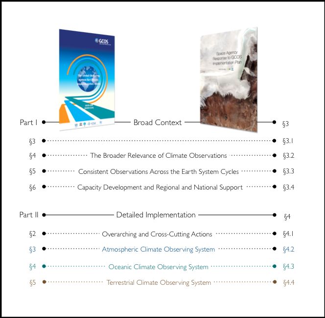
Table of Contents
Executive Summary ......................................................................................................................................... vi
1 Introduction ................................................................................................................................................1
1.1
Background................................................................................................................................................................................. 1
1.2
Purpose of this document ................................................................................................................................................. 1
1.3
Approach to Responding to GCOS Implementation Plan............................................................................. 1
1.4
Terminology............................................................................................................................................................................... 2
2 The Architecture for Climate Monitoring from Space .....................................................................4
2.1
Role of Satellites in a Global Climate Observing System ................................................................................ 4
2.2
The Joint CEOS/CGMS Working Group on Climate ....................................................................................... 5
3 Response to Part I: Broad Context ......................................................................................................7
3.1
Observations for Adaptation, Mitigation and Climate Services ................................................................... 7
3.2
The Broader Relevance of Climate Observations............................................................................................... 9
3.3
Consistent Observations Across the Earth System Cycles ............................................................................ 9
3.4
Capacity Development and Regional and National Support ......................................................................10
3.5
Calibration and Validation of Satellite Data, Assessment and Intercomparison ..............................11
4 Response to Part II: Detailed Implementation ................................................................................ 12
4.1
Overarching and Cross-Cutting Actions .................................................................................................................12
4.2
Atmospheric Climate Observing System................................................................................................................18
4.3
Oceanic Climate Observing System ..........................................................................................................................25
4.4
Terrestrial Climate Observing System......................................................................................................................33
Annex A. Acronyms .................................................................................................................................. 48
Annex B. Mapping from GCOS IP to Space Agency Response ....................................................... 55
Annex C. Contributors ............................................................................................................................. 62
vWGClimate Response to GCOS Implementation Plan Executive Summary The Committee on Earth Observation Satellites (CEOS) and Coordination Group for Meteorological Satellites (CGMS), in the form of the Joint CEOS/CGMS Working Group on Climate (WGClimate), are pleased to present a response to the 2016 GCOS Implementation Plan, reiterating their commitment to address the Actions required for the implementation of the Global Climate Observing System (GCOS). CEOS and CGMS, international organizations of 60 Members and Associates and 15 Members respectively, have had the honour to report on Space Agency activities to GCOS on several previous occasions. Space Agencies have continued to evolve their systematic observation of the climate system, now spanning several decades, strengthening scientific knowledge on climate, and supporting the provision of knowledge-based information to climate services to under-pin informed decision- making. Space Agencies are framing their activities through the implementation of the Strategy Towards an Architecture for Climate Monitoring from Space, 2013 – developed by a team comprised of representatives from CEOS, CGMS, and the World Meteorological Organization (WMO). The Role of the Architecture for Climate Monitoring from Space In response to the continuing challenge of monitoring climate variability and climate change from space, CEOS, CGMS and WMO have accelerated development of the global Architecture for Climate Monitoring from Space. A recent, substantial, advance in the development of the Essential Climate Variable (ECV) Inventory has led to an unprecedented insight into the activities of Space Agencies across the ECV spectrum, resulting in the detailed characterisation of over 900 Climate Data Records (CDRs) that directly respond to the GCOS ECV requirements. The ECV Inventory enables the identification of existing and potential future gaps in the provision of the climate data requested by GCOS. An analysis of the gaps between GCOS needs and the CDRs delivered by Space Agencies is currently underway, and will include the identification of actions to close any identified gaps. We are pleased to leverage this activity for the direct benefit of GCOS, thereby more accurately targeting, and responding to, GCOS needs. The Architecture for Climate Monitoring from Space is central to our response to the GCOS Implementation Plan, and frames our response to both the Broad Context and Detailed Implementation actions articulated by GCOS. Broad Context Space Agencies are implementing programmes explicitly aimed at producing CDRs that respond to the ECVs requested by GCOS. Moreover, climate services directly benefit from the wealth of space-derived climate data products being systematically generated by Space Agency programmes. The continuing implementation of the global Architecture for Climate Monitoring from Space, and in particular the ECV Inventory, provides strong evidence of the on-going commitment of Space Agencies in terms of the application of sustained resources and investments. Efforts have accelerated at a regional level also. For example, the WMO designated Regional Climate Centres (RCCs) are being implemented to generate and deliver more regionally-focused high-resolution data and products, as well as training and capacity building. The WMO has been making concerted efforts to implement RCCs, in close coordination with its Regional Associations, Commission for Climatology and Commission for Basic Systems. On mitigation, CEOS continues to support the Global Forest Observations Initiative implementing the United Nations Collaborative Programme on Reducing Emissions from Deforestation and Forest Degradation or REDD+.
WGClimate Response to GCOS Implementation Plan

Detailed Implementation including Preliminary Identification of Gaps
The overall response by Space Agencies to Atmosphere-related Actions is strong, although some
important gaps remain. The meteorological satellite constellation, coordinated by CGMS, provides
strong heritage and a backbone for satellite data characterising atmospheric physics, dynamics, and
composition. Many agencies have launched programmes for generating satellite CDRs, and
international coordination through Sustained Coordinated Processing of Environmental Satellite
Records for Climate Monitoring (SCOPE-CM) has improved efficiency. Space Agencies are also
enhancing coordination of a satellite constellation for monitoring CO2 and CH4, and are stepping
up their investments. Unresolved gaps include the uncertain future of satellite-based
measurements of precipitation, and no plans for continuing measurements of the upper
tropospheric and stratospheric composition profile for better understanding the Earth's radiation
balance, among other benefits. In addition, a space-based calibration mission could not be realized
in full, and shortfalls have been identified in following up on key research missions that have
revolutionised our understanding of atmospheric processes (e.g. CALIPSO/CloudSat for aerosol-
cloud interaction by measuring the 3D structure of clouds and aerosol layers).
Our uncertainty of Terrestrial ECV products is a function of the temporal resolution of satellite
data acquisition and the availability of in situ observations. Due to cloud cover, and low illumination
conditions at high latitudes, significantly higher errors occur when optical data are used in isolation.
Uncertainty is also difficult to assess, as in situ data are extremely limited and, in general, not
consistent in space and time. Satellite multi-sensor and multi-product inter-comparisons have been
minimal so far for lake temperature, as the availability of a reasonable set of overlapping products
is a pre-requisite for such activities. Lake in situ monitoring and satellite observation targets need to
be extended, and a common database derived on which to focus production and subsequent
validation activities for all products. A higher spatial resolution is required for monitoring lake ice
extent. Temporal resolution has considerably improved for many Arctic regions as more daily data
are acquired. There is a strong need to establish lake sites for algorithm development and
validation, for the purpose of long-term monitoring.
A major drawback for the true monitoring of constantly changing glaciers in steep high-mountain
topography is the missing availability of Digital Elevation Maps (DEMs) from high-resolution sensors
for ortho-rectification of the related satellite data. For Glacier Area the requirement for annual
frequency is unnecessary because decadal change is sufficient. For glacier elevation change this is
opportunistic and depends on DEM availability, quality and characteristics. For glacier flow velocity,
observations on a sub-annual basis are possible using SAR and optical sensors especially for surge
events, other instabilities, and seasonal velocity variations. Existing Fire ECV products (Brunt Area
and Fire Radiative Power) are approaching target requirements for spatial resolution, although may
not reach temporal requirements, but merged products derived from multi-sensor data may be
close to satisfying both requirements. The International Land Surface Temperature and Emissivity
Working Group (ILSTE 1 ) has been initiated to bring developers and producers together to
improve coordination and to make products more accessible to users.
Space Agencies intend a strong response overall to actions related to Oceans, with some gaps.
Meteorological and operational optical and thermal missions will provide a strong instrumental
backbone for sea surface temperature, with areas requiring stronger action focussed around
maximising the quality of long records and integrating diurnal cycle observations from
geostationary platforms. For SST and sea ice, the absence of plans across many agencies for low-
frequency passive microwave radiometry remains concerning. An increased emphasis on evolving
better ocean heat flux and sea surface dynamic state products constrained by observations needs
to be sustained. Co-operation and continuity in sea surface height / sea level are strong, although
validation and uncertainty estimation remain challenging. Observational continuity for ocean
surface reflectance observation for ocean biogeochemistry looks secure from polar orbiting


1                    ilste-wg.org


   vii
WGClimate Response to GCOS Implementation Plan platforms, and effort is strong in radiometric validation. Further product evolution is needed for phytoplankton biomass estimation and long-term climate data record stability. The global salinity record from L-band microwave frequencies is progressing, with multi-mission synthesis a priority. Salinity mission extensions are planned or under review that will extend the record beyond a decade, although no new salinity missions are in the pipeline thereafter. As Agencies continue to invest in the efforts necessary to create CDRs from their archives of observations it is also understood that CDRs must have stringent quality characteristics that enable quantitative analysis of climate change and variability over decades. Therefore Space Agencies are addressing in situ fiducial reference measurements for verifying the accuracy and stability of satellite CDRs, integration of CDRs across evolving constellations of sensors for a particular ECV, assessment of consistency between variables, and reducing the knowledge gaps in the understanding of uncertainty in CDR products across all spatial/temporal scales relevant to climate. These activities have been applied across the atmospheric, oceanic and terrestrial domains, and substantial progress has been made for a significant number of CDRs. viii
WGClimate Response to GCOS Implementation Plan

1 Introduction
1.1                                                   Background
The Global Climate Observing System (GCOS), a joint undertaking of the World Meteorological
Organization (WMO), the Intergovernmental Oceanographic Commission (IOC) of the United
Nations Educational, Scientific, and Cultural Organization (UNESCO), the United Nations
Environment Programme (UNEP) and the International Council for Science (ICSU), was
established in 1992 to ensure that the observations and information needed to address climate
related issues are obtained and made available to all potential users.
At the 7th Conference of the Parties (COP 7) to the United Nations Framework Convention on
Climate Change (UNFCCC) in 2001, the UNFCCC Subsidiary Body on Scientific and
Technological Advice (SBSTA) invited GCOS to consider an integrated (satellite and in situ)
approach, including the exploitation of new and emerging methods of observation to the
measurement of climate change. At COP 9 in 2003, GCOS was invited to develop a phased 5–
10–year implementation plan. COP 10 in 2004 invited Parties with Space Agencies to have those
Space Agencies provide a coordinated response 2 to the recommendations in the 2004
Implementation Plan.

1.2                                                   Purpose of this document
The purpose of this report is to provide a consolidated Space Agency response to actions from
the Global Climate Observing System3 in the form of GCOS 200, recently updated from GCOS
1544. Technical supplements responding to actions per ECV in detail will be provided in early
2018.

1.3                                                   Approach to Responding to GCOS Implementation Plan
This document comprises the following parts:
                           •                          Introduction (§1).
                           •                          The Architecture for Climate Monitoring from Space (§2).
                           •                          Response to Part I: Broad Context (§3).
                           •                          Response to Part II: Detailed Implementation (§4).
                           •                          Acronyms (Annex A).
                           •                          Mapping from GCOS IP to Space Agency Response (Annex B),
                           •                          Contributors (Annex C).


2                    GCOS, 2006: Systematic Observation Requirements for Satellite-based Products for Climate: Supplemental details
                     to the satellite-based component of the “Implementation Plan for the Global Observing System for Climate in
                     Support of the UNFCCC”. GCOS-107, WMO, Geneva, September 2006.
3                    GCOS, 2016: The Global Observing System for Climate: Implementation Needs. GCOS-200, WMO, Geneva,
                     October 2016
4                    GCOS, 2011: Systematic Observation Requirements for Satellite-based Products for Climate: Supplemental details
                     to the satellite-based component of the ”Implementation Plan for the Global Observing System for Climate in
                     Support of the UNFCCC (2010 Update)”. GCOS-154, WMO, Geneva, December 2011.


     1
WGClimate Response to GCOS Implementation Plan
1.4 Terminology
Essential Climate Variable
An Essential Climate Variable (ECV) is a geophysical variable that is associated with climate
variation and change as well as the impact of climate change onto Earth. GCOS has defined a set
of ECVs for three spheres, atmospheric, terrestrial and oceanic5,6.
ECV Product
Many GCOS ECVs are sub-divided into so called ECV Products. The term “Product” denotes
long-term data records of values or fields of ECVs derived from FCDRs7. For instance, the water
vapour ECV has 3 ECV Products: total column water vapour, tropospheric and lower-stratospheric
profiles of water vapour, and upper tropospheric humidity, which describe different aspects of
water vapour in the atmosphere. However, the definitions provided for ECV7 are not always
consistent for all ECVs. For some cases, e.g. the ECV Sea Ice, there is only one ECV Product that
covers 4 different variables/parameters for which requirements are provided. The ECV Inventory
and the associated questionnaire names each variable/parameter for which requirements are
provided an ECV Product. A consistent mapping is provided in the ECV Inventory Questionnaire
Guide8.
GCOS Requirements
A GCOS Requirement as used in this document refers to the quantitative requirements provided
for each ECV7 They denote Horizontal Resolution, Vertical Resolution, Temporal Resolution,
Accuracy and Stability.
Fundamental Climate Data Record
A Fundamental Climate Data Record (FCDR) is a well-characterised, long-term data record,
usually involving a series of instruments, with potentially changing measurement approaches, but
with overlaps and calibrations sufficient to allow the generation of products that are accurate and
stable, in both space and time, to support climate applications9. FCDRs are typically calibrated
radiances, backscatter of active instruments, or radio occultation bending angles. FCDRs also
include the ancillary data used to calibrate them. The term FCDR has been adopted by GCOS and
can be considered as an international consensus definition.
Thematic Climate Data Record
A Thematic Climate Data Record (TCDR) is the counterpart of the FCDR in geophysical9. It is
closely connected to the ECVs but strictly covers one geophysical variable, whereas an ECV can
encompass several variables. For instance, the ECV Cloud Properties includes at least five different
geophysical variables, each of them constituting a TCDR. The term TCDR has been taken up by
many Space Agencies and can be considered as de facto standard.
5 Bojinski et al. (2014): The concept of Essential Climate Variables in Support of Climate Research, Applications, and
Policy https://doi.org/10.1175/BAMS-D-13-00047.1
6 GCOS-82, 2003: The Second Report on the Adequacy of the Global Observing Systems for Climate in Support of
the UNFCCC, 74 pp, available at: http://www.wmo.int/pages/prog/gcos/Publications/gcos-82_2AR.pdf
7 GCOS-154, 2011: Systematic Observation Requirements for Satellite-based Products for Climate: Supplemental
details to the satellite-based component of the ”Implementation Plan for the Global Observing System for Climate in
Support of the UNFCCC (2010 Update)”. WMO, Geneva, December 2011.
8 WGClimate, 2016: ECV Inventory: Questionnaire Guide v2.4.
9 Dowell, M., P. Lecomte, R. Husband, J. Schulz, T. Mohr, Y. Tahara, R. Eckman, E. Lindstrom, C. Wooldridge, S.
Hilding, J. Bates, B. Ryan, J. Lafeuille, and S. Bojinski, 2013: Strategy Towards an Architecture for Climate Monitoring
from Space. Pp. 39, available at: www.ceos.org; www.wmo.int/sat; http://www.cgms-info.org/ GCOS, 2015: Status of
the Global Observing System for Climate, GCOS-195, WMO, Geneva.
2WGClimate Response to GCOS Implementation Plan
Interim Climate Data Record
An Interim Climate Data Record (ICDR) is a Fundamental or Thematic Climate Data Record
regularly updated with an algorithm / system having maximum consistency to the FCDR or TCDR
generation algorithm / system10. The update cycle depends on the user needs for climate extremes
and might range from pentad to monthly.
10 WMO Workshop on Operational Space-based Weather and Climate Extremes Monitoring Geneva, Switzerland 15-
17 February 2017 Meeting Report.
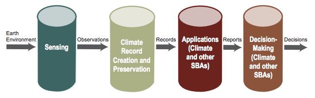
3WGClimate Response to GCOS Implementation Plan 2 The Architecture for Climate Monitoring from Space The space-based architecture for climate monitoring11 forms the major international reference for the contribution of Space Agencies towards a fulfilment of GCOS goals. It is also reflecting the contribution of Space Agencies to the monitoring and observation pillar of the Global Framework of Climate Services (GFCS). The implementation of this architecture is coordinated by the joint CEOS/CGMS Working Group Climate (WGClimate) that was established in 2013. 2.1 Role of Satellites in a Global Climate Observing System Earth observation satellites provide a vital means of obtaining observations of the Earth system from a global perspective and comparing the behaviour of different parts of the globe for many of the Essential Climate Variables. Their global nature distinguishes satellite observations from ground- based and airborne measurements that are more limited in spatial coverage, but nevertheless necessary to constrain and validate information derived from space, and provide data on variables not accessible from space. Satellite climate data records that meet the GCOS requirements enable climate monitoring, studies of trends and variability, climate research, assimilation into numerical weather prediction models to produce long-term reanalyses of Earth System components, provision of boundary conditions for and verification of climate models, climate impact modelling, and, ultimately, decision making in many societal sectors including agriculture, water resource and coastal management, forestry, transportation, and insurance applications. Through this satellite observations play also an important role realizing the potential of Earth observations and geospatial information to advance the Group on Earth Observations (GEO) 2030 Agenda and enable societal benefits through achievement of the Sustainable Development Goals (SDGs). In principle, reliable space-based observations can support authoritative statements on climate change by climate services needed to empower international organizations, governments and the private sector to make informed decisions on prevention, mitigation, and adaptation strategies (see Figure 1 for the value adding chain). However, the past and the current observing systems have not been primarily designed with a climate perspective, therefore inventories are needed to document the contributions of current and planned observing systems for climate purposes. The architecture calls for a constellation of research and operational satellites, broad, open data- sharing policies and contingency planning. It includes agreements that are essential for bringing continuity to long-term and sustained climate observations that were established for weather observations. The sustained involvement of both research and operational agencies is a prerequisite for success. The Research and Operations paradigm envisioned by the architecture demands the sustained expert understanding of new and legacy sensors and many support activities to derive the needed ECV climate data records. This requires the continued effort of both research and operational agencies which is organized by the CEOS/CGMS Working Group Climate. 11 M. Dowell, P. Lecomte, R. Husband, J. Schulz, T. Mohr, Y. Tahara, R. Eckman, E. Lindstrom, C. Wooldridge, S. Hilding, J.Bates, B. Ryan, J. Lafeuille, and S. Bojinski, 2013: Strategy Towards an Architecture for Climate Monitoring from Space. Pp. 39, available at: www.ceos.org; www.wmo.int/sat; http://www.cgms-info.org/ GCOS, 2015: Status of the Global Observing System for Climate, GCOS-195, WMO, Geneva. 4
WGClimate Response to GCOS Implementation Plan

Figure 1 : Value adding chain schematically describing the use of satellite-based information for decision making (from
                                                  Dowel et al., 2013).

2.2      The Joint CEOS/CGMS Working Group on Climate
A Joint Group and Joint Response
The Joint CEOS/CGMS Working Group Climate was founded in 2013 to enable all major Space
Agencies to contribute via a coordinated CEOS and CGMS approach to the implementation of
the Architecture for Climate Monitoring from Space. This joint working group, in addition to facilitating
the implementation of the architecture, also provides a coordinated and unique voice for the
response of Space Agencies to the GCOS and GFCS needs and plans.
The over-arching goal of the Joint CEOS/CGMS Working Group on Climate (WGClimate) is to
improve the systematic availability of Climate Data Records including the GCOS ECVs through the
coordinated implementation, and further development of the Architecture for Climate Monitoring
from Space. More specifically, the coordination is designed to achieve three main objectives:
    •    Provision of a structured, comprehensive and accessible view as to what Climate Data
         Records are currently available from satellite missions of CEOS and CGMS members, or
         their combination;
    •    Creation of the conditions for delivering further Climate Data Records, including multi-
         mission Climate Date Records, through best use of available data to fulfil GCOS
         requirements (e.g. by identifying and targeting cross-calibration or re-processing
         gaps/shortfalls);
    •    Optimisation of the planning of future satellite missions and constellations to expand
         existing and planned Climate Data Records, both in terms of coverage and record length,
         and to address possible gaps with respect to GCOS requirements.
The first and third objectives are collectively fulfilled via the establishment of an ECV Inventory and
the analysis of its content with respect to the needs of GCOS also addressing the level of
compliance with the GCOS Climate Monitoring Principles and the Guidelines for the Generation of
Datasets and Products and GCOS requirements as provided in the GCOS Implementation Plan.
The second objective is addressed both by single agency and multi-partner projects, in particular
those implemented in the frame of the WMO SCOPE-CM and GSICS initiatives.
The WGClimate supports the work of GCOS in defining and delivering the ECVs required by the
UNFCCC and supports the overall relation of CEOS to the UNFCCC, its subsidiary bodies, and to
the Intergovernmental Panel on Climate Change (IPCC).
The WGClimate has also been tasked by CEOS and CGMS to coordinate the response of Space
Agencies to the GCOS implementation plan, and to report to SBSTA/UNFCCC on CEOS/CGMS
climate actions.


     5
WGClimate Response to GCOS Implementation Plan Moreover, WGClimate and its member agencies are committed to continuing to apply the GCOS Climate Monitoring Principles and guidelines. In addition to the space segment, Space Agencies resource data management systems that facilitate access, use and interpretation of data and products, treating these as essential elements of climate monitoring systems. 6
WGClimate Response to GCOS Implementation Plan

3 Response to Part I: Broad Context
3.1                                                   Observations for Adaptation, Mitigation and Climate Services

3.1.1 Adaptation

Guidance and best practice for adaptation observations (GCOS Action G1)

Space Agencies are instrumental in providing capability to meet adaptation needs, by addressing
the actions of the GCOS Implementation Plan via the Architecture for Climate Monitoring from
Space. These capabilities include, for example, coordinating observation systems to inform
adaptation stakeholders, providing public access to high quality and standardized data on the
vulnerabilities to climate change impact, and operationalizing the addressing of adaptation at
national, regional and local scales.
WGClimate will continue to support, and liaise closely with, GCOS on its continuing adaptation
efforts as defined in GCOS-200 (§3.1), and spanning all adaptation action categories, namely
requirements and guidance, acquisition of data, data, stewardship, climate services and international
cooperation.

Specification of high-resolution data (GCOS Action G2)


WGClimate and its members continue to support specification of high resolution climate data
requirements via their existing programmes. These activities typically include user consultation on
space segment missions, user engagement on climate data production programmes and
cooperation with users in provision of operational climate services. High-resolution data, together
with various types of non-satellite data, continue to play a pivotal role in climate services as
exemplified by the WMO report12 supplement to the Strategy Towards an Architecture for Climate
Monitoring from Space.

3.1.2 Climate Indicators

Development of indicators of climate change (GCOS Action G3) and Indicators for Adaptation
and Risk (GCOS Action G4)


Establishment of Climate Indicators
Space Agencies are aware of the need to support the building of indicators of climate change.
Many of the underlying climate data records are already available. What needs to be enhanced is a
more systematic and correct consideration of uncertainty estimates.
Space Agencies are aware of the need to support the building of indicators for tracking climate
change, based on the production of climate data records, including the systematic catering of
uncertainties. To this end, planetary vital signs should be reliable, simple, have a long-term history,
reflect a range of possible symptoms of climate change, integrate as far as possible many wider
effects of change, be easily interpreted and conversely difficult to misinterpret, either by accident
or intent13.


12 WMO No. 1162. https://library.wmo.int/pmb_ged/wmo_1162_en.pdf
13 CEOS EO Handbook for COP-21 §5 p42


     7
WGClimate Response to GCOS Implementation Plan In addition, the Paris Agreement has led to the need for a new comprehensive set of climate indicators that should be forward-looking, i.e. aid decision-makers in assessing future climate change impact and the effects of measures to adapt to and mitigate impacts. Such indicators will rely on satellite and other observations, as well as modelling and forecasting capabilities, and are yet to be agreed internationally. A number of parameters for tracking climate change such as sea level, snow cover, temperature, precipitation, ocean heat content and the cryosphere are covered by the WMO Statement on the Status of the Climate and supported by GCOS, and a WMO-GCOS position on indicators of climate change is established14. Many CEOS and CGMS agencies will continue to enable CDRs critical for the formation of climate change indicators. Some ECVs are depending on multi-agencies inputs, e.g. precipitation that needs a multitude of measurements provided by several CEOS and CGMS agencies. For those WGClimate will foster multi-agency activities to deliver high quality climate data records that stand up to the needs for detecting and understanding climate change. Architecture – From Satellite Missions to Services Satellites are critical in providing the observations of numerous such parameters. For example, arctic sea ice extent has been measured since the late 1970s by passive microwave imaging systems and for the last approximately 20 years by active radar imaging sensors also. In addition, dedicated satellites (ICESat, CryoSat) with specific relevant technologies have allowed measurements not only of the extent, but also the thickness and hence total volume of sea ice to be made. Sea level is now measured most accurately, and globally, by a series of precise altimeters; these measurements go back over 20 years and will continue into the future due to the Sentinel 6 series of missions. Climate data record development is also geared by specification of indicators by GFCS and climate service providers. WGClimate and its agencies plan to continue dialogue with international and national climate service providers, with the aim of the Space Agencies highlighting, optimizing and shaping their climate data production to address the emerging needs of climate indicators. In this respect the European Commission, European Centre for Medium-Range Weather Forecasts (ECMWF), European Space Agency (ESA) and European Organisation for the Exploitation of Meteorological Satellites (EUMETSAT), for instance, are programmatically aligned to symbiotically address each other’s needs, and this includes consideration of ECV product uncertainty in production of climate change indicators. WMO is planning to enhance its interaction with users of satellite-based CDRs and ECV products, as a contribution to the Architecture for Climate Monitoring from Space, the GFCS Climate Services Information System and User Interface Platform. These are being established to facilitate the dialogue between the providers of observations and monitoring products, climate modellers, and service providers. In context to the development of climate services to express the changing climate, provision of climate services for responding to adaptation needs and growing risk are equally crucial. Already embedded and proactive within WGClimate, users of satellite-based climate data records and climate service providers will be performing a more pronounced role in the future in the working group in light of the Paris Agreement. This will benefit the highlighting, aligning and shaping of climate data products in support of downstream climate services. The vehicle for this amplified collaboration between Space Agency climate data providers, direct users of satellite climate data records, and climate service providers is the Architecture for Climate Monitoring from Space15. The architecture, which logically and physically links space derived climate infrastructure and data to climate services and policy decision making support, has enabled productive dialogue across the variety of players within WGClimate. 14 https://library.wmo.int/opac/doc_num.php?explnum_id=3418 15 M. Dowell, P. Lecomte, R. Husband, J. Schulz, T. Mohr, Y. Tahara, R. Eckman, E. Lindstrom, C. Wooldridge, S. Hilding, J.Bates, B. Ryan, J. Lafeuille, and S. Bojinski, 2013: Strategy Towards an Architecture for Climate Monitoring from Space. Pp. 39. Online: http://www.wmo.int/pages/prog/sat/documents/ARCH_strategy-climate-architecture-space.pdf 8
WGClimate Response to GCOS Implementation Plan

The expanded role in WGClimate of WMO, the European Commission, ECMWF and other
parties involved in climate services for adaptation and risk will include leading consultative roles in
the following:
                               •                           addressing the shortfalls in the ECV Inventory between status of ECV datasets and their
                                                           associated ECV requirements in the GCOS Implementation Plan, therefore providing
                                                           valuable climate adaptation and risk insight on the consequences of those shortfalls.
                               •                           mapping ECV Inventory records to any new indicators of climate adaptation and risk, and
                                                           consequently informing Space Agencies in the prioritisation of space resources to
                                                           optimally address downstream needs in light of such indicators.
                               •                           raising governmental, intergovernmental and non-governmental policy needs which
                                                           emerge by means of new indicators of adaptation and risk, therefore supporting the
                                                           development direction of the architecture.
These activities will be systematically addressed through the WGClimate development of the
architecture, including the continued development of the ECV Inventory. Additionally, the ECV
Inventory, provides future opportunities for intelligently and conveniently interrogating the mapping
between climate data records and adaptation services.

3.2                                                   The Broader Relevance of Climate Observations
This section addresses GCOS-200 Part I §4 (“The Broader Relevance of Climate Observations”).
Although Action G5 is neither directly nor indirectly actionable by Space Agencies, WGClimate
will remain vigilant in identifying opportunities for maximising benefit from ECVs in implementing
the GEO SDG process. Any such insight will be shared with GCOS and SBSTA through existing
reporting cycles.
With the adoption in September 2015 by the United Nations of the 2030 Agenda for Sustainable
Development, a set of 17 “Sustainable Development Goals” (SDGs) were defined to be achieved
in each country by 2030. Space Agencies, such as ESA16, have confirmed their capabilities in the
explicit support of these.
WGClimate recognizes the significant value in supporting the SDGs, both to inform, and be
informed by, GCOS and SBSTA. This is particularly urgent in context to the Paris Agreement.

3.3                                                   Consistent Observations Across the Earth System Cycles
This section addresses GCOS-200 Part I §5 (“Consistent Observations Across the Earth System
Cycles”).
The emergent need for holistic indicators of climate change following the Paris Agreement has
magnified the need for WGClimate to adopt a similarly holistic forming to its climate data
products and services, so informing observations across the Earth System cycles.
The analysis of the ECV Inventory content shows that many ECV Products needed to quantify the
energy, water and carbon cycles are already provided from satellite data. CEOS and CGMS
agencies already provided energy flux products at the top of atmosphere and surface (radiation
and heat fluxes) before those became ECV Products.


16 ESA Activities Supporting Sustainable Development, Catalogue. 2016.


     9
WGClimate Response to GCOS Implementation Plan WGClimate member agencies attempt to demonstrate the usefulness of satellite products for considering energy and water budgets, e.g. the NASA MEaSURES programme17. Quantifying the global carbon cycle is essential to understanding many of the dramatic changes taking place in the Earth system, particularly those resulting from the burning of fossil fuel and land- use change. Forests absorb, store and release large amounts of carbon; therefore, they are a key component of the carbon cycle. Despite this crucial role, forest biomass is poorly quantified in most parts of the world and is an ECV currently labelled missing in the ECV Inventory. Responding to this challenge, ESA will start a CCI project dedicated to biomass using suitable satellite missions of today and the past to improve our current understanding of this ECV and prepare for future dedicated missions like NASA’s GEDI/NISAR and ESA’s Biomass missions set out to provide measurements of forest biomass and forest height. Reliable knowledge of forest biomass also underpins the implementation of the UN Reducing Emissions from Deforestation and forest Degradation, REDD+, initiative – an international effort to reduce carbon emissions from deforestation and land degradation in developing countries. WGClimate will continue to actively support GEO carbon actions and strategy. 3.4 Capacity Development and Regional and National Support This section addresses GCOS-200 Part I §6 (“Capacity Development and Regional and National Support”). The activities of WGClimate and its members are not entirely congruent with those GCOS actions focused on capacity development as defined by the GCOS Implementation Plan. Nevertheless, WGClimate can, and will, unreservedly support GCOS in its implementation of a GCOS communication strategy (Action G9), by raising awareness of the GCOS Implementation Plan and publicizing the need for sustainable climate observations, particularly for developing countries, in its own Space Agency communication strategies. WGClimate member agencies are active in supporting capacity building initiatives focussed on climate services through the provision of access to climate data records and information, related user training and project management support. For instance, EUMETSAT has supported Africa through a Memorandum of Understanding signed with the African Union Commission and in the framework of the MESA programme funded by the 11th European Development Fund. EUMETSAT has in parallel supported the formulation of new projects expected to start in 2017- 2018, i.e. the GMES and Africa and the ACP Climate Services projects, funded by different EU instruments. Most agencies are strengthening their communication of climate monitoring activities, and these can be harmonized where possible with the GCOS communication strategy. Building capacity of users to ingest satellite-based climate data and products into their operations and to interpret uncertainty is urgently required in many parts of the world where the competencies and infrastructure required are no match for the surging demand for high-quality climate information and services. The WMO-CGMS Virtual Laboratory for Education and Training in Satellite Meteorology (Vlab) is establishing a programme of virtual climate roundtables where experts and users, for example from WMO Regional Climate Centres, can interact regularly and address region-specific capacity needs. The European Commission through its ACP programme is implementing programmes to foster the uptake of satellite data and derived information. 17 L’Ecuyer, T.S., H.K. Beaudoing, M. Rodell, W. Olson, B. Lin, S. Kato, C.A. Clayson, E. Wood, J. Sheffield, R. Adler, G. Huffman, M. Bosilovich, G. Gu, F. Robertson, P.R. Houser, D. Chambers, J.S. Famiglietti, E. Fetzer, W.T. Liu, X. Gao, C.A. Schlosser, E. Clark, D.P. Lettenmaier, and K. Hilburn, 2015: The Observed State of the Energy Budget in the Early Twenty-First Century. J. Climate, 28, 8319–8346, https://doi.org/10.1175/JCLI-D-14-00556.1 10
WGClimate Response to GCOS Implementation Plan

3.5     Calibration and Validation of Satellite Data, Assessment and
        Intercomparison
Ground-based observing networks of sufficient quality and coverage (in terms of parameters,
temporal and geographic space) are very important for validating satellite-based records, calibrating
satellite sensors and thus for fully reaping the benefits of space-based systems. Space Agencies
support calibration and inter-calibration of sensors through the Global Space-based Intercalibration
System (GSICS) and dedicated activities in support of calibration such as innovative lunar
calibration with dedicated instrumentation. Moreover, the maintenance of dedicated calibration
and validation sites providing fiducial reference measurements are key.
Gaps in such networks have been identified for most ECVs. Space Agencies should step up their
engagement with the operators of ground-based networks to address network gaps. Network
design priorities should be established where appropriate, for example using Observing System
Simulation Experiments or collocation studies.
Space Agencies will develop a comprehensive assessment of the adequacy of ground-based
networks for validation of climate data records, including a gap analysis and the resources required
to address issues related to the sustainability and geographic coverage of surface-based validation
networks. This should build on work undertaken e.g. within the CEOS WGCV and the European
GAIA-CLIM research project.
Space Agencies in collaboration with the operators of surface-based networks will invest in
collocation studies demonstrating the value of using multiple data sources for estimating the
uncertainty in atmospheric profiles.


Agencies continue to support the intercomparison of satellite data and derived products through
international science working groups which unite leading experts in the field, and other users of
satellite data. Intercomparisons foster product understanding including uncertainties, and guide the
uptake of satellite data by users.


   11
WGClimate Response to GCOS Implementation Plan
4 Response to Part II: Detailed
Implementation
4.1 Overarching and Cross-Cutting Actions
4.1.1 Planning, Review and Oversight
Development of an ECV Inventory (GCOS Action G11) and Gap Analysis (GCOS Action G12)
The objectives associated with ECV Inventory development are intrinsic to the fulfilment of the
core objectives assigned to WGClimate in its Terms of Reference, and form a pivotal asset in the
implementation of the Climate Monitoring Architecture. The development of the ECV Inventory
was implemented applying a cyclic approach as indicated in Figure 2 that was tied to the term of
the Chair of the WGClimate.
The ECV Inventory provides a repository of verified information for the characteristics of two
types of ECV Climate Data Records:
• Climate data records that already exist. This forms the current component of the
inventory;
• Climate data records that do not currently exist, but are firmly planned to be delivered as
part of an already approved programme. This forms the future component of the
inventory.
A first version of the ECV Inventory had been developed in 2015 followed by a major
redevelopment during the last two years that resulted in the ECV Inventory Version 2.0 which
forms the basis for this report. ECV Inventory Version 2.0 describes the status on 31 December
2016 versus the 2011 GCOS Satellite Supplement but contains additional data records matching
new ECV Products in the updated GCOS IP. WGClimate is committed to continue gradual
updates of the ECV Inventory including an analysis of the content versus the GCOS needs. This
analysis leads to recommendations and actions for CEOS and CGMS that allow an optimised
planning for future satellite missions and constellations to expand the existing and planned ECV
CDRs and to deliver the data records by single agency and multi-partner projects.
Besides the analyses performed by WGClimate, the ECV Inventory is seen useful to provide
information to the users of climate data records, climate services and other applications on what is
available for their work. For data providers and data record developers the Inventory can help to
concentrate investments onto what is missing and to foster collaborative approaches at
international level such as the WMO SCOPE-CM. In addition the ECV Inventory has the potential
to become a resource for capacity building activities that rely on the access to climate data
records. Relevant activities such as the WMO-CGMS Virtual Laboratory for Training and Education
in Satellite Meteorology and CEOS Working Group on Capacity Building and Data Democracy
have been informed about the publication of the ECV Inventory.
Entries for the ECV Inventory Version 2.0 have been received from 10 CEOS and CGMS
Agencies. The entries are based on a Questionnaire that provides traceability to the GCOS
principles, guidelines and requirements. The preparation of the ECV Inventory content involved
almost 100 individuals which shows the high engagement of the agencies to provide high quality
information to the ECV Inventory.
12WGClimate Response to GCOS Implementation Plan
Cycle Stage #2: Data Incorporation and Quality Control. Cycle Stage #1: Collection of New & Updated
Information from Data Providers.
All information collected during Cycle Stage #1 is quality
controlled and absorbed into the ECV Inventory Metadata concerning all ECV data products
spanning all space agencies is collected.
Cycle Stage #3: Gap Analysis.
The shortfalls between each
ECV data product referred to
in the ECV Inventory and the 1
GCOS requirements are 2
identified
3
Cycle Stage #4: 4
Action Plan.
Actions are defined Act
to close the gaps
identified in Cycle
Action.
Stage #3.
Activity by space
agencies and other
climate change
stakeholders to realise
the actions identified in
Cycle Stage #4.
Figure 2 : Cyclic approach for the establishment of the ECV Inventory, the analysis of its content leading to the
identification of gaps and derivation of recommendations and actions to mitigate such gaps.
Table 1 provides the number of climate data records in the ECV Inventory with a very large
complement for the Atmosphere and smaller numbers for land and ocean. A first analysis on gaps
related to ECVs and individual ECV Product as defined by GCOS (GCOS-200) reveals that for
two (above ground biomass and sea surface salinity) no entry exist in the current and future part
of the Inventory. As this reflects the status on 31 December 2016 we know today that both
missing ECVs will be addressed by ESA in the future. In addition, no entries exist for lightning and
ocean surface currents because the Inventory was established against the 2011 Satellite
Supplement.
13WGClimate Response to GCOS Implementation Plan
Domain Total Current Future Total (Cycle #1)
All 913 496 417 ~200
Atmosphere 658 376 282 N/A
Land 135 56 79 N/A
O cean 120 64 56 N/A
Table 1 : Number of data record entries in the ECV Inventory for Cycle#2
In terms of ECV Products with respect to the 2011 Satellite Supplement18 in the current data
holdings 3 ECV Products are missing for atmosphere (tropospheric ozone profiles, NO2
tropospheric column, SO2 and HCHO tropospheric columns), 5 are missing for the terrestrial part
(fire radiative power, ice sheet elevation data and mass change, areas of Lakes and above ground
biomass) and two for ocean (sea surface salinity and wave height).
The number of missing ECV Products in the future part of the ECV Inventory is shown in Table 2
Atmosphere Land Ocean
Ozone Profile in Upper Elevation Data Ocean Colour - Chlorophyll-a
Stratosphere and Mesosphere Concentration
Ozone Profile in Upper 2D Vector Outlines, Ocean Surface Stress
Troposphere and Lower Delineating Glacier Area
Stratosphere
Tropospheric Ozone Profile Groundwater Volume Change Sea-surface Salinity
Tropospheric CH4 Column Ice Shelves
Stratospheric CH4 Profile Soil Moisture - Freeze/Thaw
Aerosol Single-scattering Fire Radiative Power
Albedo
Aerosol-layer Height Moderate-resolution maps of
Land-cover Type
Aerosol-extinction Coefficient Above-ground Biomass
Profile
NO2 Tropospheric Column
SO2, HCHO Tropospheric
Columns
CO Tropospheric Column
Solar Spectral Irradiance
Total Solar Irradiance
Table 2 : Missing ECV Products in the future part of the ECV Inventory.
Due to the large number of data records the gap analysis for the ECV Inventory Version 2.0 has
not been finalised and a first comprehensive gap analysis report will become available in spring
2018. This will also contain specific recommendations and actions to mitigate found gaps.
4.1.2 Data Management, Stewardship and Access
Open Data Policies (GCOS Action G15)
18 GCOS-154, 2011: Systematic Observation Requirements for Satellite-based Products for Climate: Supplemental
details to the satellite-based component of the ”Implementation Plan for the Global Observing System for Climate in
Support of the UNFCCC (2010 Update)”. WMO, Geneva, December 2011.
14You can also read