Soils with dark subsurface horizons in saline basins in the Brazilian Pantanal
←
→
Page content transcription
If your browser does not render page correctly, please read the page content below
Rev Bras Cienc Solo 2022;46:e0210088                                                                                                                  Article

                                                      anos

                                                Division – Soil in Space and Time | Commission – Soil Genesis and Morphology

                                                Soils with dark subsurface
                                                horizons in saline basins in the
                                                Brazilian Pantanal
                                                Andressa Rosas de Menezes(1)*  , Ademir Fontana(2)  , Lúcia Helena Cunha dos
                                                     (1)
                                                Anjos    , Marcos Gervasio Pereira(1) and Jolimar Antônio Schiavo(3)
                                                (1)
                                                    Universidade Federal Rural do Rio de Janeiro, Departamento de Solos, Seropédica, Rio de Janeiro, Brasil.
                                                (2)
                                                    Empresa Brasileira de Pesquisa Agropecuária, Embrapa Solos, Campo Grande, Mato Grosso do Sul, Brasil.
                                                (3)
                                                    Universidade do Estado do Mato Grosso do Sul, Departamento de Solos, Aquidauana, Mato Grosso do Sul,
                                                    Brasil.

                                                ABSTRACT: Soils in the Brazilian Pantanal classified as Espodossolos and registered in the
                                                literature diverge from the central concept of pedogenesis by podzolization, especially due to
                                                the high values of pH and basic cations, although the morphology is similar to that of spodic
                                                horizons. In this sense, this study hypothesized that the neutral to alkaline conditions along
                                                the edges of the saline basins in the Lower Nhecolândia region do not inhibit the podzolization
                                                process nor the development of spodic soils. The objectives were to analyze the attributes of
                                                soils with spodic features and evaluate whether they correspond to a podzolization process.
                                                Four profiles in a transect in Lower Nhecolândia were selected, where the morphology
                                                indicated the presence of a spodic horizon. Three profiles (P1, P2 and P4) were located in a
* Corresponding author:
E-mail: andressa.rosas@hotmail.com              bay and one in the transition between a bay and a “cordilheira” (small elevation between
                                                lagoons) (P3). The soils were analyzed for particle size, chemistry and X-ray fluorescence
Received: July 20, 2021                         (XRF), as well as organic carbon (C org), total carbon (TC) and XRF of the nodules. The
Approved: November 30, 2021
                                                complexity of features and characteristics of soil profiles in the Lower Nhecolândia region
How to cite: Menezes AR,                        indicate multiple pedogenetic processes in this environment. The characteristics of all profiles
Fontana A, Anjos LHC, Pereira                   denote a redoximorphic process: poor profile development (except for P3), mottles formed
MG, Schiavo JA. Soils with
dark subsurface horizons in                     by precipitation of Fe and Mn oxides, as well as presence of Fe and Mn nodules. The organic
saline basins in the Brazilian                  matter content of these nodules is mostly greater than or equal to that of the surrounding
Pantanal. Rev Bras Cienc Solo.
2022;46:e0210088.                               material, and aluminum is relatively not higher than in the fine earth. This reinforces a
https://doi.org/10.36783/18069657rbcs20210088
                                                rexodimorphic process in the horizons with spodic features. The occurrence of sodic and
Editors: José Miguel Reichert
                                                solodic characters, as well as clay accumulation in P3 also characterize the sodification
and Pablo Vidal Torrado .                       process. The neutral to alkaline pH values in water, high sum of bases and low C org and Al
                                                oxide contents of the studied soils all contradict the occurrence of a podzolization process.
Copyright: This is an open-access
article distributed under the                   However, Fe, Al and C org accumulation in the nodules and some B horizons indicate a
terms of the Creative Commons                   spodic character. Also, the fact that SiBCS criteria classify the studied soils as Espodossolos
Attribution License, which permits
unrestricted use, distribution,                 indicates the relevance of establishing limits for chemical attributes, which would adjust the
and reproduction in any medium,                 taxonomy of soils with a spodic character according to their pedogenesis.
provided that the original author
and source are credited.                        Keywords: sedimentary pedoenvironment, pedogenesis, podzolization, spodic horizon.

                                                                                              https://doi.org/10.36783/18069657rbcs20210088                1
Menezes et al. Soils with dark subsurface horizons in saline basins of the Brazilian...

                                     INTRODUCTION
Spodic horizons are the result of a process of podzolization. They occur mainly in
pedoenvironments in humid climate, both temperate and tropical, the parent material
consists of felsic rocks or highly permeable sediments and the texture is sandy, mostly
with low levels of basic cations causing organic matter dispersion or forming cation-organic
matter complexes in the subsurface horizons (De Coninck, 1980; Sauer et al., 2007;
Kämpf and Curi, 2012; IUSS Working Group WRB, 2015; Santos et al., 2018). According
to the World Reference Base for Soil Resources (WRB; IUSS Working Group WRB, 2015),
the subsurface horizon which “contains illuvial substances composed of organic matter
and Al or of illuvial Fe” is defined as a spodic diagnostic horizon. In the Brazilian Soil
Classification System (SiBCS; Santos et al., 2018), spodic horizons are dominated by
illuviated active amorphous material composed of organic matter and aluminum (Al),
with or without iron (Fe).

As in the temperate climate regions (Guillet et al., 1975; Beyer, 1996; Ferro-Vázquez et al.,
2014; Valerio et al., 2016; Brock et al., 2020), soils with spodic horizons in Brazil mainly
have a sandy texture, with subsurface accumulation of organic carbon, acidic-range
pH(H2O) and low base saturation. However, in Brazilian soils with spodic horizons, the
levels of Fe and Al oxides and organic carbon (C org) are much lower than in temperate
environments; in most freely drained environments, the profiles have a surface horizon
with low C org content and a thick eluvial horizon (Menezes et al., 2018). Poorly drained
soils with a spodic horizon may have an H histic horizon, no or a thin E horizon, a smooth
topography in the transition between horizons and presence of mottles (Buurman et al.,
2013; Lopes-Mazzetto et al., 2018).

The Brazilian Soil Classification System (SiBCS) characterizes soils formed by the
podzolization process by the presence of a spodic horizon as diagnostic subsurface
horizon, classified in the order of Espodossolos (Santos et al., 2018). Such soils occur
in all regions of Brazil in different ecosystems: in the Amazon basin (Ishida et al, 2018;
Tadini et al., 2018), coastal tablelands (Rêgo et al., 2019; Schiavo et al., 2020), coastal
sandbanks (Buurman et al., 2013; Lopes-Mazzetto et al., 2018; Silva Neto et al., 2018),
the Pantanal basin (Schiavo et al., 2012; RCC, 2012), as well as in cold and humid
climates of the high-altitude mountains in the Atlantic Forest biome (Schaefer et al.,
2002; Simas et al., 2005).

In a previous study, Menezes et al. (2018) reported wide variation in the morphological and
chemical attributes of spodic horizons of 154 Brazilian profiles described as Espodossolos
in the literature. Among these profiles, those in the Pantanal had a particularly high
pH(H2O) and high sodium (Na) and low C org and Al contents. These conditions diverge
totally from the central concept of the podzolization process and the current definition of
spodic horizons in the international soil classification systems and literature (De Coninck,
1980; Chesworth and Macias-Vasquez, 1985; Lundström et al., 2000; Sauer et al., 2007;
IUSS Working Group WRB, 2015).

The Pantanal has a unique hydrology and geomorphology and is a special biome as well,
but pedology studies in this environment are still scarce. This reinforces the relevance
of describing, characterizing and understanding soils with “spodic features”, including
their pedogenetic processes, reported in the literature for large areas of the Pantanal.
In addition, studies about these soils may provide information to better define the
Espodossolos soil order in the SiBCS (Santos et al., 2018).

Considering the uniqueness of the soils with spodic features reported in the Pantanal,
compared to other environments of Brazil (Menezes et al., 2018), this study hypothesized
that the neutral to alkaline conditions, found along the edges of saline basins in the
Pantanal wetlands, do not inhibit the podzolization process and the development of
spodic soils. In this sense, the objectives were to analyze the attributes of soils with

                                                       Rev Bras Cienc Solo 2022;46:e0210088                       2
Menezes et al. Soils with dark subsurface horizons in saline basins of the Brazilian...

spodic features in the Lower Nhecolândia region and to evaluate if they correspond to
the podzolization process.

                           MATERIALS AND METHODS
Brazilian Pantanal in the Lower Nhecolândia subregion

The Pantanal wetland of Brazil is characterized by predominantly flat lowlands and
strongly influenced by the water regime of the Upper Paraguay river Basin (IBGE,
2019a). This region in the Midwest of Brazil is the largest inland flooded area in the world
(approximately 150,988 km²) (IBGE, 2019a). The Paraguay river is the main collector of
waters from several affluents, the largest of which is the fluvial megafan of the Taquari
river. The Pantanal wetland of Brazil covers an approximate area of 49,000 km², with
elevations of 85-190 m, i.e., the average topographic gradient is very low (0.36 m km-1)
(Assine, 2005; Zani et al., 2012).

This study was carried out specifically in the Lower Nhecolândia, a Pantanal subregion
in the southwest of the Taquari megafan. This region is characterized by thousands of
rounded lagoons, which can contain fresh water, as in bays, or brackish water in salines.
These waterbodies are set among specific formations, regionally known as “cordilheiras”,
“vazantes” or “corixos”, according to their peculiar features (Boin et al., 2019). The
“vazantes” are several kilometers long, temporary channels that connect the bays during
the flood season, similar to the “corixos”, which can however remain dry for years. The
“cordilheiras”, different from what the name would suggest, are small elevations of about
2 m above the level of the lagoon around them.

The Lower Nhecolândia subregion is covered by sandy clay sediments from the Pantanal
Formation, with incipient clay and organic matter stratification and cemented by ferruginous
material, but without current sediment input (Godoi et al., 2001; Assine, 2005). The soils
are substantially sandy, with predominance of fine sand and salt accumulation, and may
have a textural gradient (Furquim et al., 2010, 2017; RCC, 2012; Schiavo et al., 2012;
Boin et al., 2019; IBGE, 2019b; Andrade et al., 2020). Specifically, soils with spodic
features occur in periodically flooded areas, such as bays, salines and “cordilheiras”
(RCC, 2012; Schiavo et al., 2012), normally under deciduous tropical Cerradão (woodland
savanna) and tropical Cerrado (open shrub) vegetation.

Local climate is Aw (tropical with summer rains), according to the Köppen-Geiger climate
classification (Aparecido et al., 2020). Due to the predominantly flat relief, the soil moisture
rises rapidly even after small rainfall events and consequently the water table. About
30 to 60 days after the beginning of the rainy season in October, the percentage of
flooded areas started to increase and peaked (70 - 75 %) in May (Hamilton et al., 1998).
According to the climatological normal of the Nhumirim Agroclimatic Station, located in
the study area, the cumulative annual rainfall is 1,176.4 mm and the dry period normally
begins in April; the annual means are 25.4 °C, 82 % relative air humidity and 1,521.2 mm
evaporation (Soriano, 2000).

Site prospection, soil profile sampling and description

The study area belongs to the Fazenda Nhumirim of Embrapa Pantanal, located in the
Lower Nhecolândia, Corumbá, Mato Grosso do Sul, Brazil. Soil surveys with mapping
units that described Espodossolos (Fernandes et al., 2007; Santos et al., 2011) and other
studies on soil profiles of this order (RCC, 2012; Schiavo et al., 2012) were analyzed.
Representative sites of soils with spodic features were identified in the field with an
auger (Figure 1).

Selected study profiles consisted of a small group near or at the edge of a saline
basin, as a result of a detailed search in a larger area for the best pedoenvironment

                                                       Rev Bras Cienc Solo 2022;46:e0210088                       3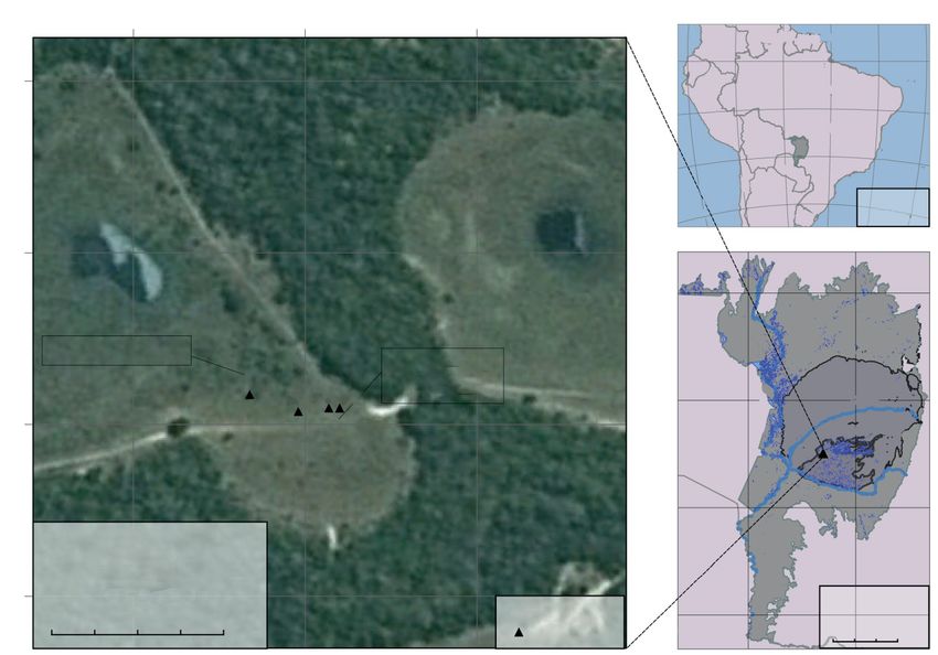
Menezes et al. Soils with dark subsurface horizons in saline basins of the Brazilian...

(a)                                  (b)

Figure 1. Auger with a sample of the surface layer (0.00-0.20 m) (a) and landscape of the profiles
with spodic features in the Pantanal of Lower Nhecolândia, Mato Grosso do Sul (b).

for the occurrence of spodic horizons. Based on that survey, a small area of greater
representativity and concentration of spodic morphological features was defined for the
description and sampling of soil profiles. Thus, previous descriptions in the literature of
the landscape conditions in which these soils occur were considered, and the selected
site can be defined as a small, highly representative area of the study subject in Lower
Nhecolândia. It was not possible to open a trench all along the transect to evaluate the
lateral continuity of the features. Although the large lateral variation in properties of
Espodossolos is often described in the literature, it was not an objective of this study
to evaluate them.

In November 2018, four trenches in parts of a transect were opened. Soil samples were
taken and the profiles morphologically described as proposed by Santos et al. (2015)
(Figure 2). The profile selection was based on features that could indicate a spodic
horizon, according to the morphological criteria defined by SiBCS (Santos et al., 2018)
and WRB (IUSS Working Group WRB, 2015).

Sample preparation, laboratory analysis and soil classification

After manual fragmentation, the crumbled soil samples were dried in a forced air circulation
oven at 40 °C and sieved (
Menezes et al. Soils with dark subsurface horizons in saline basins of the Brazilian...
538200 538400 538600 80°W 70°W 60°W 50°W 40°W 30°W
South America
COL
0°S
7901000
ECU
Brazil
10°S
PER
n
ea
Pantanal
Oc
“Cordilheira”
Pacific Ocean
BOL
tic
20°S
lan
PAR
At
Bay
CHI
Semi-denciduous ARG Polyconic
Projection
Bay
30°S
URU
forest SIRGAS2000
790800
400000 600000
Pantanal
8200000
Native pasture qu
ari
Megafan
Andropogon
Paraguay River
Ta
P3 hypogynus
8000000
P2P4 P1 ari R
iver
790600
Bolivia Taqu
Baixa Nhecolândia
Dry bay
7800000
Negro River
Universal Transverse Mercator “Cordilheira”
Projection – Zone 21S
Geodetic Reference System Paraguay
790400
SIRGAS2000
7600000
UTM – 21S
0.05 0 0.05 0.1 0.15 km Legend SIRGAS2000
0 40 80 120 km
Soil profiles
Figure 2. Soil profiles in the Pantanal of Lower Nhecolândia, Mato Grosso do Sul. Sources:
Shapefile of Brazilian biomes - IBGE (2019a); cartographic base - IBGE (2019c); image of study
area - Google Earth Pro.
Soluble salts (Na+ and K+) were extracted from the fine earth fraction in aqueous medium
and analyzed by flame photometry. Afterwards, the electrical conductivity of the saturation
extract was measured by a digital conductivity meter. To identify carbonates and Mn
oxides, respectively, the effervescence of the samples was evaluated with 10 % HCl and
hydrogen peroxide (20 volumes) (Santos et al., 2015).
Sulfuric acid (solution ratio of 1:1) was used for extraction from the fine earth fraction to
determine Fe2O3 and Al2O3 contents. The pedogenetic oxides Fe, Al and Mn were also measured
in the fine earth fraction, after extraction with sodium dithionite-citrate-bicarbonate
solution (Fed and Mnd) and ammonium oxalate acid (Feo, Alo and Mno). The ratio Feo/Fed
was calculated to evaluate the predominance of more or less crystalline forms of Fe
oxides in the horizons.
For the elemental composition of Si, Fe, Al, Ti, Mn and P by X-ray fluorescence (XRF),
fine earth fraction and nodule samples were prepared according to the glass bead
method. The samples were ground in a vibrating mill and then 0.5000 g was weighed
directly into a platinum crucible together with 5.0000 g of lithium tetraborate/lithium
metaborate mixture (66/34 %). After the material was blended, the crucible was taken to
an Eagon 2 automatic melting machine for fusion to glass beads at 1050 °C for 26 min.
Most samples were subjected to only one, but some to a second melting cycle, in case
of incompletely melted material.
The spectra of the glass beads were obtained by wavelength dispersive X-ray fluorescence
spectrometry (WD-XRF; ZSX Primus; Rigaku) using a rhodium (Rh) tube. Samples were
read once, for an average period of 16 min. Readings were based on a quantitative curve
in empirical mode, constructed from reference samples (Table 1).
The reference standards of the multielement curve for sample quantification are specified
in table 2. Data import was performed using ZSX software. The oxide forms of each
element were obtained after applying the following conversion factors: Si to SiO2: 2.12;
Rev Bras Cienc Solo 2022;46:e0210088 5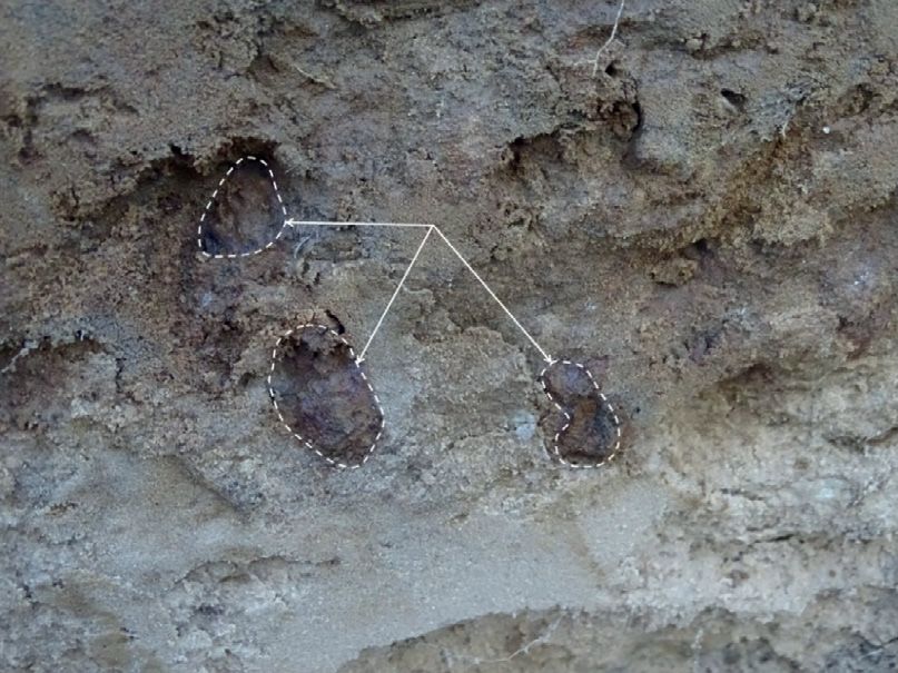
Menezes et al. Soils with dark subsurface horizons in saline basins of the Brazilian...
Al to Al2O3: 1.89; Fe to Fe2O3: 1.43; Ti to TiO2: 1.29; Mn to MnO2: 1.22; P to P2O5: 2.29.
Then, the data were converted from percentage to g kg-1.
For each soil profile, the difference between the Fe2O3 contents obtained by XRF and
by sulfuric acid extraction was calculated. The distribution of Fe2O3 and Al2O3 that are
not part of the clay fraction was analyzed for a possible relation with organic carbon
contents, which is a prerequisite for the podzolization process. Furthermore, in cases
where the content of a certain element extracted by the sulfuric acid method exceeded
that obtained by XRF, the difference between XRF and sulfuric acid extraction was
assigned zero (content) for interpretation and discussion.
Based on the laboratory analyses data and morphological characteristics, the profiles
were classified according to the Brazilian Soil Classification System - SiBCS (Santos et al.,
2018) and WRB (IUSS Working Group WRB, 2015).
RESULTS
Pedoenvironment, soil profile morphology and particle‐size distribution
The profiles were selected in two different parts of the transect: three adjacent to a bay
area (P1, P2 and P4) and one in the transition between the bay and the “cordilheira” (P3)
(Table 3), here named “saline lagoon edge”. Profiles P1, P2 and P4 lie in a seasonally
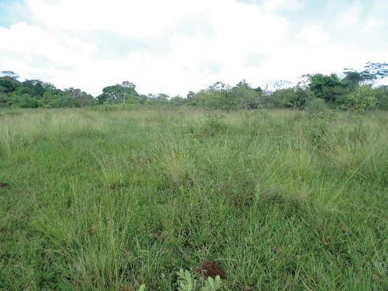
flooded area, with a flat relief, covered by “capim vermelho” vegetation (Andropogon
hypogynus), at an ellipsoidal elevation of 80 m (Table 3). Profile P3 lies in a flat relief area,
with an ellipsoidal elevation of 82 m and under a vegetation known locally as “campo
limpo” (Table 3). The vegetation is native pasture composed of Mesosetum sp., Setaria
geniculata and Rychardia sp., with the occurrence of Bromelia antiacantha, Vernonia
polysphaera and Laurus nobilis.
Table 1. Parameters adopted in the quantitative curve for sample readings by XRF
Element Line Crystal Angle (deg) Detector
Al Kα PET 144.712 PC
Fe Kα LiF1 57.502 SC
Mn Kα LiF1 62.956 SC
P Kα PET 89.392 PC
Si Kα PET 109.006 PC
Ti Kα LiF1 86.134 SC
SC: scintillation counter; PC: proportional counter.
Table 2. Reference standards of multi-element curve
Reference standards Al Fe Mn P Si Ti
%
Montana Soil I – NIST 2710a 5.95 4.320 0.2140 0.1050 31.10 0.311
Montana Soil II – NIST 2711a 6.72 2.820 0.0675 0.0842 31.40 0.317
San Joaquin Soil – NIST 2709a 7.37 3.360 0.0529 0.0688 30.30 0.336
Flint Clay – SRM 97b (National
20.76 0.831 0.0047 0.0200 19.81 1.430
Bureau of Standards)
Plastic Clay – SRM 98b
14.30 1.180 0.0116 0.0300 26.65 0.809
(National Bureau of Standards)
Brick Clay - SRM 679 (National
11.01 9.050 0.1730 0.0750 24.34 0.577
Bureau of Standards)
Rev Bras Cienc Solo 2022;46:e0210088 6
Menezes et al. Soils with dark subsurface horizons in saline basins of the Brazilian...
All profiles are marked by the presence of a seasonal high-water table level. Profiles P3
and P4 are located at the highest and lowest points of the transect, respectively, where
the water table, at the time of soil sampling, was 0.45 and 0.43 m deep (Table 3); and
between 0.52 and 0.55 m on P1 and P2.
Table 3. Pedoenvironment characterization of soil profiles from the Brazilian Pantanal of Lower Nhecolândia, Mato Grosso do Sul State
Profile Relief Geomorphological situation Drainage Vegetation Elevation Water table level
m
“Capim vermelho”
Imperfectly
P1 Flat Bay area vegetation (Andropogon 0.80 0.52
drained
hypogynus)
“Capim vermelho”
Imperfectly
P2 Flat Bay area vegetation (Andropogon 0.80 0.55
drained
hypogynus)
Native pasture.
Transition between the bay and Imperfectly
P3 Flat Vegetation known as 0.82 0.45
the “cordilheira” drained
“campo limpo”.
“Capim vermelho”
Imperfectly
P4 Flat Bay area vegetation (Andropogon 0.80 0.43
drained
hypogynus)
(a) (b)
A
A
Bhsc
Bh
Bhsc
Bsc
Bhc Bhs
E E
Bstc
Bhc Bhc
C
C
(c) (d)
A1
A
A2
Bhs
Bs1
E1
Bs2
E2 Bsc
Bh C
Btgn
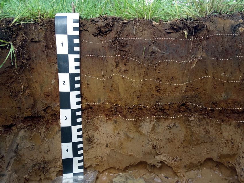
Figure 3. Profiles in a flat relief area, on the edge of a bay (a. P1; b. P2; and d. P4) and in a
transition area between a bay and a “cordilheira” (c. MS-1 profile described in the 10th Brazilian
Soil Classification and Correlation Meeting, located at the same coordinates as profile P3).
On the date of soil collection, horizon B of P3 could not be photographed because of the high
water table (0.45 m deep in relation to the surface) in the Brazilian Pantanal. Source of image of
P3: Ademir Fontana.
Rev Bras Cienc Solo 2022;46:e0210088 7
Menezes et al. Soils with dark subsurface horizons in saline basins of the Brazilian...

The profiles in the bay (P1, P2 and P4) have a shallow solum and a horizon sequence of
A, B and C, except for P2 which has a thin discontinuous E horizon overlaying parts of
B (Figure 3). The soil profile in the transitional area between the bay and “cordilheira”
(P3) has a much thicker E horizon, deeper solum and less distinctive mottles or nodules
than the others (Table 4).

The colors are gray to dark brown in the A horizons, brown or black in B and pale in
C. Based on the color criteria and presence of iron nodules, according to the SiBCS
(Santos et al., 2018), the B horizons were identified in the field as spodic, with black to
dark brown colors of Bh(c) or Bhs(c) horizons and Bs(c) with at least one color hue 5YR
or 10YR, values 3 or 4 and chromas 4 or 6 (Table 4), except for the Btgn horizon of P3,
which has a green and black variegated color. The eluvial horizons of the P3 profile are
dark yellowish brown and yellowish-brown.

In the P3 and P4 profiles, the smooth transitions between the horizons indicate the
dominant upward vertical flow of the water table (Figures 3c and 3d). On the other hand,
the predominantly wavy or broken transitions between horizons in P1 and P2 suggest
a greater lateral contribution to the water flow at this intermediate transect points
(Figures 3a and 3b).

The surface horizons have a weak, small to medium, granular structure, influenced by
the content of organic matter and roots of the grass vegetation, while B, C and E horizons
have no aggregates, except for Bstc of P2, which has a weak to moderate structure of
small to medium subangular blocks (Table 4).

The mottles are black and yellowish-brown, and reddish brown or yellowish red mottles
are due to oxide precipitation and nodule formation, respectively, of Mn and Fe, mainly
in B horizons (Table 4, Figure 4). All profiles have small to large, irregularly shaped Fe
and Mn nodules (Table 4). In bay soils (P1, P2 and P4), the nodules are mainly in the B
horizons, but there are also isolated large nodules in the C horizon of P1 and P2 (Figure 4),
while P3 has nodules in the E horizon. The nodule quantity was identified as very low
or low in most of the horizons, with exception of the Bsc horizon of profile P4, in which
nodules are frequent (Table 4). It is noteworthy that the nodules were very hard and
could not be broken by hand. However, in the laboratory, during the preparation of the
fine earth fraction, most of them were broken up, so that the gravel content observed in
the particle-size analysis does not reflect the quantity of nodules observed in the field.

Profiles P1 and P2 contain coarse gravel and/or fine and medium gravel in all B horizons,
except for the Bsc (P1) and Bh (P2) horizons, which contain Fe and Mn nodules (Table 5).
The granulometry is dominated by the sand fraction, consequently, the main textural
class is sandy, with exception of the Bstc horizon in P2 and the Btgn horizon in P3, which
is loamy sand (Table 5). Among the sand fractions, analysis showed a greater participation
of fine sand, followed by medium sand (Table 5).

There was an absolute increase of clay contents in the B horizons (Table 5), except in
P1, located in a flat relief that does not favor clay removal from the surface horizons or
translocation to subsurface horizons. The occurrence of any lithological discontinuity,
caused particularly by sediment deposition, was evaluated, and no significant variation was
observed between the fine earth fractions along the horizons of any soil profile (Table 5).

Chemical attributes, pedogenetic oxides and elemental composition

The values of pH(H2O) are equal or greater than 6.0 in most horizons and they increase
with depth (Table 6). The pH(KCl) values, which are lower than the pH(H2O) for all horizons,
decrease from surface horizons to subsurface, and they increase in the C horizon (Table 6).
Therefore, the ΔpH values, commonly used to denote predominance of cation adsorption
in the exchange complex, show more negative ΔpH values in the B horizons than in the
surface horizons (Table 6).

                                                       Rev Bras Cienc Solo 2022;46:e0210088                       8
Menezes et al. Soils with dark subsurface horizons in saline basins of the Brazilian...
Table 4. Morphology of profiles in the Lower Nhecolândia subregion of the Brazilian Pantanal, Mato Grosso do Sul
Horizon Layer Structure Dominant matrix color Mottles Boundary Nodules
m
Profile P1 - flat relief, bay area, imperfectly drained, elevation of 80 m
5YR 3/4 M. Sm. Dis
A 0.00-0.12 (0.10-0.13) W, S/M, G 5YR 3/1 WC -
and N 2/ F. Sm. Dis.
0.12 (0.10-0.13) - VF, Sm, H, I, Fe
Bhsc SG 5YR 3/2 5YR 3/4 M. Me. Dis. WA
0.16 (0.13-0.20) and Mn
0.16 (0.13-0.20) - VF, Sm, H, I, Fe
Bsc SG 5YR 3/4 5YR 4/4 M. Co. Dis. WA
0.27 (0.26-0.29) and Mn
(0.24-0.33) - VF, Sm and C,
Bhc SG N 2/ - BA
(0.26-0.24) H, I, Fe and Mn
0.27 (0.26-0.29) - VF, C, H, I, Fe
C SG - - -
0.52+ and Mn
Profile P2 - flat relief, bay area, imperfectly drained, elevation of 80 m
A 0.00 - 0.10 (0.08-0.11) W, S, G 10YR 3/1 - WC -
0.10 (0.08-0.11) -
Bh SG 10YR 3/2 - BC -
0.12 (0.08-0.16)
0.12 (0.08-0.16) - VF, Sm, H, I, Fe
Bhsc SG 7.5YR 3/2 - WC
0.14 (0.11-0.17) and Mn
0.14 (0.11-0.17) - VF, Sm, H, I, Fe
Bhsc/E SG 10YR 3/2 10YR 4/4 F. Sm. Dis. BC
0.23 (0.17-0.30) and Mn
0.23 (0.17-0.30) - W/M, S/M, VF, Sm, H, I, Fe
Bstc Var. N 2/ and 10YR 3/4 - WC
0.31 (0.30-0.33) SB and Mn
0.31 (0.30-0.33) - F, Sm, H, I, Fe
Bhc SG 10YR 2/1 WC
0.37 (0.36-0.38) and Mn
0.37 (0.36-0.38) - VF, C, H, I, Fe
C SG 10YR 8/1 N 2/ F. Me. Pro.
0.55+ and Mn
Profile P3 - flat relief, transition between bay and “cordilheira”, imperfectly drained, elevation of 82 m
A1 0.00-0.10 W, S/M, G 10YR 3/1 - SC -
A2 0.10-0.18 W, S, G 10YR 4/1 - SA -
VF, Sm, H, I, Fe
E1 0.18-0.28 SG 7.5YR 3/4 - SC
and Mn
VF, Sm, H, I, Fe
E2 0.18-0.45 SG 10YR 5/4 - -
and Mn
Bh 0.85-1.05 - N 2/ - - -
+
Btgn 1.05-1.15 - Var. N 2/ and 5GY 5/2 - - -
Profile P4 - flat relief, bay area, imperfectly drained, elevation of 80 m
A 0.00-0.065 W, S/M, G 10YR 3/3 5YR 5/8 C. Sm. Dis. SC -
Bhs 0.065-0.09 SG Var. 7.5YR 2.5/3 and 7.5YR 3/1 - SA -
VF, Sm, H, I, Fe
Bs1 0.09-0.145 SG 7.5YR 3/4 - SC
and Mn
VF, Sm, H, I, Fe
Bs2 0.145-0.205 SG 10YR 4/6 - SC
and Mn
Fr, Sm and C,
Bsc 0.205-0.27 SG Var. 5YR 3/4 and 5YR 3/3 - SA
H, I, Fe and Mn
C 0.27-0.45+ SG 10YR 6/4 10YR 4/4 F/C Me. Dis. -
Horizon subscripts according to Santos et al. (2015) where the letter h correspond to accumulation of illuvial organic matter, s correspond to accumulation
of illuvial Al and Fe oxides and c correspond to concretion and nodules. In WRB Guidelines for Soil Description (Jahn et al., 2006), letters c and s have
the same description as Santos et al. (2015), but letter h stands for organic matter accumulation, which, in this case, may occur in surface horizons
or in subsurface horizons through illuviation. Structure: (i) development degree: W – weak and M – moderate; (ii) size: S – small and M – medium;
(iii) shape: G – Granular, SB – Subangular blocks and SG – single grains; Color: Var – variegated; Mottles: (i) Quantity: F – few, C – common and
M – many; (ii) Size: Sm – Small, Me – Medium and Co – Coarse; (iii) Contrast: Dis – Distinct and Pro – Prominent; Boundary: (i) Topography: S – smooth;
W – wavy and B – broken; (ii) Distinctness: C – clear, A – abrupt. Water table level: P1 – 0.52 m; P2 – 0.55 m; P3 – 0.45 m; P4 – 0.43 m. Nodules: (i)
Quantity: VF – Very few (less than 5 % of volume); F – Few (5 to 15 % of volume); Fr – Frequent (15 to 40 % of volume); (ii) Size: Sm – Small (diameter
1 cm); (iii) Shape: I – Irregular; (iv) Hardness: H - Hard; (v) Nature: Iron and manganese. There was no presence of
carbonates in any profile. Coarse and medium gravel are composed of Fe and/or Mn nodules in P1 and P2. The Btgn horizon was sampled (auger)
and the structure could not be evaluated. However, sampling occurred at the same location as the MS-1 profile described in the 10th Brazilian Soil
Classification and Correlation Meeting (RCC, 2012), so that the authors decided to assume the identification of this event.
Rev Bras Cienc Solo 2022;46:e0210088 9Menezes et al. Soils with dark subsurface horizons in saline basins of the Brazilian...
(a) (b)
Iron nodules
Figure 4. Iron nodules in detail in the C horizon of profile P1 (a) and manganese nodules in the
C horizon of profile P2 (b).
The cation exchange complex shows the greatest contribution of Ca2+ and Mg2+, while
Al3+ was not detected or at very low quantities (Table 6). The distribution of Ca2+ and
Mg2+ contents, in general, followed organic carbon and clay, in the A and B horizons,
and varied with the development degree of the profile. In the bay soils, K+ and Na+
accumulated mainly in the B horizon, immediately above the C horizon; while in P3, they
were concentrated in the horizon overlying Btgn (Table 6).
As similarly observed for exchangeable cations, the S values were high (above 1.0 cmolc kg-1)
in most horizons except Bsc (P1), A2 (P3), Bs1 and Bs2 (P4) (Table 6). In general, the S
values in all profiles varied according to the clay and organic carbon content and with
depth. The V% values exceeded 50 % in all horizons of P1, P2 and P3, except in Bhsc of
P1 and C of P4 (Table 6).
The exchangeable sodium percentage (ESP) increases with depth, with maximum values
of 24 % in P1 and P4, 28 % in P2 and 13 % in P3 (Table 6). Consequently, according
to SiBCS (Santos et al., 2018), the Bhsc, Bhsc /E, Bstc, and Bhc horizons of P2, and
Bh and Btgn horizons of P3 fit the criteria for a solodic character; and horizons C of
P1, P2 and P4 have a sodic character. In this sense, the surface horizons have slightly
higher soluble K+ and Na+ contents than the B horizons (Table 6). In the same way,
electrical conductivity decreases with depth in the order: A horizons > 0.8 mS cm-1 25 °C,
B horizons -Menezes et al. Soils with dark subsurface horizons in saline basins of the Brazilian...
Table 5. Particle-size distribution of profiles in the Lower Nhecolândia subregion of the Brazilian Pantanal, Mato Grosso do Sul
Fractions of the total sample Granulometric composition of fine earth
Horizon Coarse Fine and Very coarse Coarse Medium Fine Very fine Total
Fine earth Silt Clay Texture
gravel medium gravel sand sand sand sand sand sand
-1
g kg
Profile P1 - flat relief, bay area, imperfectly drained, elevation of 80 m
A 0 0 1000 11 29 457 429 39 965 22 12 Sand
Bhsc 0 36 964 16 29 354 534 30 963 21 16 Sand
Bsc 0 0 1000 24 25 271 602 40 962 17 21 Sand
Bhc 12 20 968 3 11 317 597 36 963 16 21 Sand
C 0 0 1000 0 9 218 694 63 985 6 9 Sand
Profile P2 - flat relief, bay area, imperfectly drained, elevation of 80 m
A 0 0 1000 10 16 285 603 43 958 15 27 Sand
Bh 0 0 1000 6 26 209 655 56 952 10 38 Sand
Bhsc 0 23 977 5 22 235 615 72 950 12 38 Sand
Bhsc/E 0 32 968 12 29 238 605 45 929 7 64 Sand
Loamy
Bstc 0 18 982 11 56 248 502 59 877 2 120
sand
Bhc 0 53 947 4 40 258 594 45 941 9 49 Sand
C 0 0 1000 0 10 168 715 84 977 11 11 Sand
Profile P3 - flat relief, transition between bay and “cordilheira”, imperfectly drained, elevation of 82 m
A1 0 0 1000 11 19 340 534 57 961 22 17 Sand
A2 0 0 1000 0 7 204 702 62 975 11 14 Sand
E1 0 0 1000 0 10 187 721 61 980 10 11 Sand
E2 0 0 1000 0 9 197 723 52 982 8 10 Sand
Bh 0 0 1000 0 7 163 711 75 956 7 37 Sand
Loamy
Btgn 0 0 1000 0 15 148 673 55 892 9 99
sand
Profile P4 - flat relief, bay area, imperfectly drained, elevation of 80 m
A 0 0 1000 9 23 320 580 32 964 10 26 Sand
Bhs 0 0 1000 11 24 236 639 51 960 11 29 Sand
Bs1 0 0 1000 19 21 249 611 51 951 13 35 Sand
Bs2 0 0 1000 18 26 336 529 44 954 5 42 Sand
Bsc 0 0 1000 59 39 194 587 50 929 10 61 Sand
C 0 0 1000 1 12 264 641 66 983 7 9 Sand
The Bsc horizons of the P1 profile and Bsc of the P4 profile presented gravel in an amount less than 1 %, however, the authors chose to keep the field
description with the subscript “c” because extremely hard and unbreakable nodules were identified with the use of hands in the field, but which fell
apart after the preparation of the fine earth fraction.
and in Btgn. On the other hand, the P2O5 values in the Bsc horizons were higher than in
the other horizons (Table 7).
In all soil profiles, there was an increase of Feo and Fed contents in the B horizons in relation
to the surface horizons, except for Feo in P1 (Table 7). The Feo/Fed ratio was predominantly
lower than or equal to 0.3 in B horizons with nodules, while in the other horizons this
ratio was higher than or equal to 0.5. These data indicate that in B horizons with nodules
there is a greater participation of more crystalline forms of Fe oxides, whereas in the
other horizons, the less crystalline forms predominate.
The aluminum values expressed as Alo, presumably in a weakly crystalline form, were less
than or equal to 0.2 g kg-1 (Table 7). In the soil profiles near the bay area, the Alo value
in the B horizons was the same or decreased with depth, except in the Bstc horizon of
Rev Bras Cienc Solo 2022;46:e0210088 11Menezes et al. Soils with dark subsurface horizons in saline basins of the Brazilian...
Table 6. Chemical attributes of profiles in the Lower Nhecolândia subregion of the Brazilian Pantanal, Mato Grosso do Sul
pH Cationic complex Saturation extract Soluble salts
Hor. ΔpH 2+ 2+ + + 3+
V ESP C org + +
H2O KCl Ca Mg K Na S Al T H2O EC K Na
-1 -1 -1 -1
cmolc kg % g kg % mS cm 25 °C cmolc kg
Profile P1 - flat relief, bay area, imperfectly drained, elevation of 80 m
A 6.0 5.2 -0.8 1.8 0.3 0.32 0.00 2.3 0.0 4.3 53 0 6.2 29 0.8 0.06 0.06
Bhsc 5.5 4.4 -1.1 0.9 0.1 0.17 0.07 1.2 0.1 3.0 39 2 2.1 26 0.3 0.02 0.03
Bsc 5.9 5.0 -0.9 0.6 0.1 0.10 0.05 0.9 0.0 1.6 55 3 0.8 23 0.3 0.01 0.02
Bhc 5.7 4.3 -1.4 1.1 0.2 0.26 0.08 1.6 0.1 2.3 69 4 0.5 20 0.3 0.02 0.02
C 6.0 4.7 -1.3 0.0 0.0 0.04 0.02 0.1 0.0 0.1 100 24 0.2 20 0.1 0.00 0.01
Profile P2 - flat relief, bay area, imperfectly drained, elevation of 80 m
A 6.6 5.6 -1.0 1.9 0.5 0.31 0.20 2.7 0.0 3.9 70 5 5.4 26 0.9 0.05 0.11
Bh 6.3 4.8 -1.5 1.5 0.5 0.46 0.22 2.6 0.0 4.4 59 5 3.3 23 0.6 0.03 0.08
Bhsc 6.6 5.0 -1.6 1.2 0.4 0.36 0.25 2.1 0.0 3.1 68 8 2.1 23 0.5 0.02 0.08
Bhsc/E 6.6 5.0 -1.6 2.0 0.8 0.54 0.40 3.6 0.0 5.3 68 8 2.5 25 0.6 0.03 0.10
Bstc 7.0 5.3 -1.7 6.9 2.9 0.64 1.20 11.5 0.0 13.3 87 9 2.1 45 0.2 0.01 0.05
Bhc 7.2 5.4 -1.8 2.6 0.9 0.47 0.49 4.5 0.0 5.2 86 9 0.8 31 0.1 0.01 0.03
C 7.2 5.7 -1.5 0.1 0.1 0.08 0.10 0.4 0.0 0.4 100 28 0.1 21 0.2 0.01 0.03
Profile P3 - flat relief, transition between bay and “cordilheira”, imperfectly drained, elevation of 82 m
A1 7.5 6.8 -0.7 2.9 0.6 0.14 0.02 3.7 0.0 4.1 90 0 7.7 28 0.8 0.03 0.01
A2 5.5 4.8 -0.7 0.7 0.1 0.09 0.01 0.9 0.0 1.6 55 1 1.1 22 0.5 0.02 0.01
E1 6.9 6.2 -0.7 0.4 0.1 0.07 0.01 0.6 0.0 0.6 100 2 0.2 22 0.4 0.01 0.01
E2 6.6 5.7 -0.9 0.2 0.1 0.07 0.01 0.4 0.0 0.4 100 3 0.7 22 0.3 0.01 0.01
Bh 7.9 6.3 -1.6 1.8 0.5 0.48 0.23 3.0 0.0 3.3 91 7 1.7 32 0.1 0.01 0.03
Btgn 7.7 5.7 -2.0 2.1 0.6 1.60 0.72 5.0 0.0 5.7 88 13 0.1 32 0.2 0.01 0.04
Profile P4 - flat relief, bay area, imperfectly drained, elevation of 80 m
A 5.8 5.1 -0.7 1.6 0.2 0.15 0.05 1.9 0.0 4.0 48 1 5.0 28 0.9 0.03 0.03
Bhs 5.8 4.6 -1.2 0.7 0.1 0.10 0.09 1.0 0.0 2.7 36 3 2.7 25 0.2 0.01 0.03
Bs1 6.2 5.1 -1.1 0.5 0.1 0.07 0.05 0.7 0.0 1.7 40 3 1.4 23 0.2 0.01 0.02
Bs2 6.2 4.9 -1.3 0.5 0.1 0.08 0.07 0.8 0.0 2.3 34 3 2.0 24 0.2 0.01 0.02
Bsc 6.3 5.2 -1.1 0.7 0.1 0.11 0.07 1.0 0.0 2.7 36 3 1.6 27 0.2 0.01 0.02
C 6.5 5.2 -1.3 0.0 0.0 0.04 0.02 0.1 0.0 0.1 100 24 0.1 24 0.1 0.00 0.01
Hor.: horizon; S: sum of bases; T: cation exchange capacity at pH 7.0; V: base saturation; ESP: exchangeable sodium percentage = (Na/T) × 100;
C org: organic carbon; EC: electrical conductivity.
P2, which was 0.1 g kg-1 higher in the A horizon (Table 7). In the Bh horizon of P3, on the
other hand, it was 0.1 g kg-1 and 0.0 g kg-1 in the overlying eluvial horizon.
There was an increase with depth in Mn contents in the weakly crystalline forms (Mno),
and in the strong and weakly crystalline forms (Mnd) in all profiles, except in P1 (Table 7).
In P3, this increase was observed in the Btgn horizon, with higher clay content and,
consequently, relatively lower permeability, which favors Mn accumulation.
Carbon and elemental composition in nodules
In horizons with spodic features, C org in the nodules varied from 1.5 to 3.0 g kg-1 and
was predominantly higher or very close to the value observed in the fine earth of the
respective horizons (Table 8). Organic carbon contents in the eluvial horizons of P3 were not
detectable. However, by the applied method, Mn competes with carbon in the oxidation with
K2Cr2O7 (0.0667 mol L-1); thus, the C org content might be underestimated, as suggested
by the high Mn contents (Table 8). Total carbon (TC) in the nodules (2.7–7.8 g kg-1),
Rev Bras Cienc Solo 2022;46:e0210088 12Menezes et al. Soils with dark subsurface horizons in saline basins of the Brazilian...
determined with a Perkin Elmer PE-2400 CHNSO elemental analyzer, exceeded the C
org values determined routinely by wet oxidation (Table 8). This observation emphasizes
the participation of organic material in the composition of the nodules.
The predominant oxides in the nodules of the B horizons were SiO2 and Fe2O3, while
in the nodules of the E horizons of P3, SiO2 and MnO2 oxides prevailed (Table 8). It is
noteworthy that nodules in the E horizons of P3 have relatively higher SiO2 contents
(around 850 g kg-1) than those in the B horizons (except for P1 – Bhc, 763.5 g kg-1 or less).
The Al2O3 and TiO2 contents were relatively close to those observed in the fine earth,
therefore, there was no accumulation of these elements in the nodules (Table 8). The
Fe2O3, MnO2 and P2O5 contents in all nodules were higher than in the fine earth of their
respective horizons, which indicates the accumulation of these elements in the nodules;
while the SiO2 contents were much lower in the nodules than in the fine earth (Table 8).
In the nodules of B horizons, the Fe2O3, MnO2 and P2O5 contents varied, respectively,
Table 7. Oxides obtained by XRF, pedogenetic oxides, Al2O3 and Fe2O3 (difference between XRF and sulfuric acid extraction) of soil
profiles in the Lower Nhecolândia subregion of the Brazilian Pantanal, Mato Grosso do Sul
XRF XRF - sulfuric acid extraction
Horizon Feo Alo Mno Fed Mnd Feo/Fed
SiO2 Al2O3 Fe2O3 TiO2 MnO2 P2O5 Al2O3 Fe2O3
-1 -1
g kg g kg
Profile P1 - flat relief, bay area, imperfectly drained, elevation of 80 m
A 975.8 12.0 24.8 1.2 0.9 0.6 13.3 0.1 0.9 14.9 0.6 0.9 9.0 1.8
Bhsc 969.4 11.9 40.0 1.2 0.6 0.4 10.1 0.1 0.4 31.2 0.4 0.3 9.9 7.0
Bsc 927.0 11.5 75.5 1.2 0.5 1.0 4.9 0.1 0.3 65.0 0.3 0.1 7.5 3.5
Bhc 987.3 16.9 17.0 1.2 0.2 0.3 3.1 0.1 0.2 7.5 0.1 0.4 7.9 1.0
C 1025.5 9.0 1.5 0.9 0.0 0.2 0.2 0.0 < DL 0.8 < DL 0.3 7.0 0.0
Profile P2 - flat relief, bay area, imperfectly drained, elevation of 80 m
A 985.7 14.9 10.0 1.5 0.3 0.3 3.1 0.1 0.3 5.0 0.2 0.6 10.9 0.0
Bh 977.8 19.0 18.5 1.6 1.3 0.3 7.1 0.1 1.3 8.3 1.0 0.9 9.0 1.5
Bhsc 967.3 16.2 33.4 1.6 1.0 0.3 5.1 0.1 0.9 26.6 0.7 0.2 8.2 4.4
Bhsc/E 896.7 19.2 80.3 1.6 1.7 0.4 7.8 0.1 1.1 61.6 1.3 0.1 8.2 11.3
Bstc 766.1 20.7 174.6 1.4 2.0 1.3 16.5 0.2 1.4 93.4 1.2 0.2 5.7 19.6
Bhc 958.7 19.0 33.1 1.4 0.5 0.3 3.2 0.1 0.4 12.3 0.3 0.3 10.0 2.1
C 1010.1 11.6 2.5 1.3 0.1 0.2 0.6 0.0 0.0 0.8 < DL 0.8 8.6 0.5
Profile P3 - flat relief, transition between bay and “cordilheira”, imperfectly drained, elevation of 82 m
A1 986.5 12.8 3.4 1.4 0.4 0.3 0.7 0.1 0.5 0.7 0.2 1.0 8.8 1.4
A2 1007.9 11.9 2.5 1.3 0.3 0.2 0.3 0.0 0.3 0.4 0.1 0.8 8.9 0.0
E1 1014.4 11.5 2.1 1.2 0.4 0.2 0.2 0.0 0.4 0.3 0.2 0.7 8.5 0.1
E2 1010.1 11.5 1.8 1.3 0.1 0.2 0.1 0.0 0.1 0.3 0.1 0.3 9.5 0.0
Bh 980.1 22.4 7.3 1.7 0.3 0.3 0.5 0.1 0.2 1.1 0.1 0.5 8.4 0.3
Btgn 933.0 41.9 15.3 2.7 2.1 0.3 0.9 0.2 1.9 1.7 1.5 0.5 11.9 0.0
Profile P4 - flat relief, bay area, imperfectly drained, elevation of 80 m
A 963.6 11.8 31.4 1.2 0.7 0.5 10.6 0.1 0.6 23.2 0.5 0.5 6.8 7.4
Bhs 956.6 11.6 44.2 1.3 0.7 0.4 10.6 0.1 0.5 35.0 0.5 0.3 7.6 3.2
Bs1 922.3 11.2 73.8 1.3 0.3 0.6 4.3 0.0 0.2 60.2 0.1 0.1 7.2 8.8
Bs2 926.6 11.4 70.4 1.3 0.4 0.5 5.3 0.0 0.2 57.9 0.2 0.1 7.4 2.4
Bsc 800.4 12.2 171.7 1.2 1.0 1.9 13.2 0.1 0.7 136.0 0.6 0.1 7.2 11.7
C 1014.4 10.4 1.8 1.2 0.0 0.2 0.2 0.0 < DL 0.4 < DL 0.5 7.4 0.0
< DL: below detection limit.
Rev Bras Cienc Solo 2022;46:e0210088 13Menezes et al. Soils with dark subsurface horizons in saline basins of the Brazilian...
Table 8. Oxides obtained by XRF and carbon in nodules of profiles in the Lower Nhecolândia
subregion of the Brazilian Pantanal, Mato Grosso do Sul
Horizon SiO2 Al2O3 Fe2O3 TiO2 MnO2 P2O5 C org TC
-1
g kg
P1 - Bhsc 573.8 11.7 347.9 1.3 2.6 3.4 2.9 4.3
P1 - Bhc 819.0 19.8 148.5 1.7 0.9 1.7 2.7 2.7
P2 - Bhsc 763.5 17.6 184.3 1.8 5.0 0.9 2.0 4.1
P2 - Bhsc/E 759.4 18.2 188.3 1.8 3.8 0.7 3.0 3.8
P2 - Bstc 560.6 14.5 349.7 1.5 2.9 3.3 1.7 2.7
P2 - Bhc 743.3 13.5 182.5 1.6 20.0 1.6 2.2 7.8
P3 - E1 851.5 13.3 40.6 1.6 73.5 0.3 0.0 3.7
P3 - E2 842.1 13.4 55.5 1.6 63.2 0.5 0.0 3.9
P4 - Bs1 343.7 11.2 521.3 1.1 1.2 4.2 1.5 2.9
P4 - Bs2 392.7 11.2 483.9 1.2 1.6 4.1 1.8 3.4
P4 - Bsc 486.2 10.1 412.9 1.1 3.0 4.1 1.6 2.7
C org: organic carbon; TC: total carbon.
from 148.5 to 521.3 g kg-1, from 0.9 to 20.0 g kg-1 and from 0.7 to 4.2 g kg-1, while in the
eluvial horizons they varied from 40.6 to 55.5 g kg-1, from 63.2 to 73.5 g kg-1, and from
0.3 to 0.5 g kg-1. There was a greater accumulation of Fe2O3 and P2O5 in the B horizons
of P4 than in the other profiles.
Soil classification
According to the SiBCS (Santos et al., 2018), spodic horizons are identified by the criteria:
“color within the range of the different types of spodic horizons, have thickness greater
than 2.5 cm”, accumulation of Fe and Al with low organic matter content. The SiBCS
highlights that to quantify Fe and Al, the elements should be extracted with oxalate
solution (Alo and Feo), but there is no criterion of a minimum value to define when there
is “accumulation”.
The Alo contents in the profiles did not indicate Al accumulation in the B horizons (Table 7).
Also, the difference between Al2O3 contents obtained by XRF and by sulfuric acid extraction
only showed Al accumulation in the Bhc horizon of P2 and Btgn of P3 (Table 7). However,
different distribution patterns were observed for Fe contents, when comparing total Fe2O3
with Fed and Feo, which could indicate Fe accumulation in the B horizons of all profiles.
The definition of a spodic horizon in the SiBCS states the accumulation of organic
matter, but the C org contents in the B horizons were lower. Also, as reported for
Alo and Feo, the SiBCS does not define a minimum value of C org to evaluate organic
matter accumulation. In this sense, the horizons met the definition of the Bs spodic
horizon with “illuvial accumulation of amorphous material, mainly aluminum and iron
combined with low contents of organic matter” (Santos et al., 2018). It is also relevant
that the nodules have a higher carbon content than the fine earth, which could indicate
a podzolization process. However, this possibility was not considered in the criteria
that define spodic horizons.
Considering the sequence of horizons in the profiles and the current definitions in the
SiBCS (Santos et al., 2018), without thresholds of C org, Al and or Fe contents or pH
values, all B horizons fit the criteria of B espódicos. Thus, all profiles were classified as
Espodossolos. Next, they were classified in the suborder of Humilúvicos - Bh underlying
A (P2 and P3) and Ferri-humilúvicos - Bhs underlying A or E (P1 and P4). Since one or
more horizons within 1.00 m were water-saturated and due to the presence of mottles
in the spodic horizons, P1, P2 and P4 were classified in the great group of Hidromórficos,
Rev Bras Cienc Solo 2022;46:e0210088 14Menezes et al. Soils with dark subsurface horizons in saline basins of the Brazilian...
whereas P3 was classified as Órtico. Finally, P1, P2 and P4 were classified as típicos at
the subgroup level, and P3 as arênico, due to the sandy texture from the surface to the
upper limit of the B horizon (layer 0.85-1.05 m).
According to the international system IUSS Working Group WRB (2015), none of the B
horizons met the criteria for spodic horizons, due to the pH(H2O) above 5.9 and/or C org
contents below 5.0 g kg-1. Thus, the profiles were classified, according to the horizons and
attributes identified and the sequence of classes in the WRB key as: P1 – Sodic Arenosol;
P2 – Sodic Stagnosol; P3 – Sodic Arenosol, and P4 – Sodic Arenosol.
DISCUSSION
Pedoenvironment, soil profile morphology and particle‐size distribution
In the Lower Nhecolândia subregion, soils with spodic features occur in very specific
areas and under restricted conditions, but not as registered by different publications and
soil maps in extensive areas of the order of Espodossolos (Brasil, 1982; Fernandes et al.,
2007; Santos et al., 2011). The soil map published by IBGE (2019b) already corrected
the previous documents, since the Espodossolos are only presented in mapping units
in association with other soil classes such as Neossolos Quartzarênicos (equivalent to
Arenosols in the WRB).
The occurrence of these profiles in an area adjacent to the bay and in a transitional
area between the bay and a “cordilheira” indicates the important role of high water
levels at these landscape points for the formation of the spodic characteristics, acting
as a physical barrier and preventing the descent of Fe and C org into deeper soil layers.
In addition, the soil profiles showed that the landscape position has a strong influence
on the horizon sequence and the topography of transitions between them, the solum
depth, presence of mottles and nodule formation. The strongly restricted drainage in
P1, P2 and P4 (bay area) prevents the formation and development of the E horizon.
Similarly, the oscillation in the water table level promotes mottle formation and Fe and
Mn nodules. In the transition between the bay and “cordilheira”, the profile had a thick
E horizon, less distinct mottles and a smaller amount of nodules. Soil profiles located at
the highest and lowest elevation points of the transect (P3 and P4, respectively), have
predominantly smooth and the others broken and wavy horizon transitions (P1 and P2).
Along the transect, the E horizon formation begins at P2 and advances laterally to P3.
In this landscape section, the stability of the water table at the top of C horizon, during
most of the year, is indicated by the smooth topography between the B and C horizons
and the less frequent occurrence or absence of mottles in the profile.
In hydrosequences of Podzols (Espodossolos) in the coastal area of southeastern Brazil,
Buurman et al. (2013) and Lopes-Mazzetto et al. (2018) also correlated the presence of
mottles, topography of the horizon transitions and development of the E horizon with
the water flow in the profiles. In these two studies, imperfectly drained profiles had
predominantly wavy or broken transitions between the spodic and overlying horizons,
whereas more poorly drained soils had predominantly smooth transitions. According
to Lopes-Mazzetto et al. (2018), mottles occur in the B horizon in imperfectly drained
soils due to Fe oxide precipitation, while poorly drained soils had no mottles and low
Fe contents. According to Buurman et al. (2013), the conversion of a spodic into an E
horizon begins with the appearance of areas of organic matter depletion due to intense
biological activity, so that the thickening of the E horizon is directly associated with the
variation in the water table.
Iron and Mn nodules in the studied profiles were not derived from past conditions or
inherited from the sedimentary parent material. This statement assumes that due to
water stagnation during the wet season in the Pantanal, elements such as Fe3+, Mn3+
Rev Bras Cienc Solo 2022;46:e0210088 15Menezes et al. Soils with dark subsurface horizons in saline basins of the Brazilian...
and Mn4+ in pre-existing nodules would change to the reduced form and migrate in the
soil solution, according to the redox potential and flood period. Thus, nodule formation
in the water table fluctuation zone, which occurs in the B horizons of bay soils and E
horizons of P3, is related to the intermittence of the current seasonal flooding conditions
and results from a redoximorphic process (Vepraskas, 2015).
Under prolonged water saturation, when O2 availability for biological respiration is reduced,
other ions are used as final electron acceptors. Thus, as the redox potential is reduced,
the Fe3+, Mn3+ and Mn4+, NO3-, sulfides, sulfates, organic matter dissimilation products
and H+ present in the soil solution are consumed in anaerobic respiration (Bartlett and
James, 1993). In the reduced form, the Fe2+ and Mn2+ ions migrate in the soil solution
according to the redox gradient and precipitate in oxidized soil zones, such as inside
aggregates, pores, roots, or in oxidized zones generated as the water table sinks. When
the water table level oscillates seasonally, the Fe movement occurs in fluxes, which can
lead to the formation of a placic horizon (Kämpf and Curi, 2012).
The presence of nodules in the subsurface horizons was previously found during a field
trip of the 10th Brazilian Soil Classification and Correlation Meeting (RCC, 2012). The
preservation of Fe originated from sediments of the Pantanal Formation with ferruginous
features (Godoi et al., 2001) is favored by the substantially flat relief, in which the leaching
or lateral removal of this element is almost non-existent (Assine, 2005).
Soils in the Pantanal basin are shallow and their genesis is strongly influenced by the
restricted drainage, in the rainy season, and the nature of the sediments. In addition,
the dry season and influence of the lakes lead to peculiar pedogenetic processes
(Furquim et al., 2010, 2017; Andrade et al., 2020), especially when compared to
the soils classified as Espodossolos in other environments of Brazil (Menezes et al.,
2018) and the Podzols described in the literature (Beyer, 1996; Buurman et al., 2013;
Ferro-Vázquez et al., 2014; Valerio et al., 2016; Ishida et al., 2018; Silva Neto et al.,
2018; Lopes-Mazzetto et al., 2018; Tadini et al., 2018; Rêgo et al., 2019; Schiavo et al.,
2020; Brock et al., 2020).
In general, the soils with spodic features in Lower Nhecolândia have weak or subtle
morphological characteristics and profile development, and a higher content of
nodules. In comparison, the Espodossolos under hydromorphic conditions described
in the coastal region and Amazonia plains have clearly defined morphological
characteristics of the spodic horizons, whereas the presence of nodules is not common
(Buurman et al., 2013; Lopes-Mazzetto et al., 2018; Silva Neto et al., 2018; Tadini et al., 2018;
Schiavo et al., 2020).
The sandy texture of the soils in this study is a common feature of Espodossolos of
different Brazilian environments (Schaefer et al., 2002; Simas et al., 2005; Buurman et al.
2013; Ishida et al, 2018; Lopes-Mazzetto et al., 2018; Silva Neto et al., 2018; Tadini et al.,
2018; Rêgo et al., 2019; Schiavo et al., 2020). The same is true for Podzols in temperate
or boreal climate regions (Beyer, 1996; Ferro-Vázquez et al., 2014; Valerio et al., 2016;
Brock et al., 2020). The predominance of the fine sand fraction reflects the particle size of
the parent material and was previously observed in the Pantanal in the same landscape
during the RCC (2012) and Schiavo et al. (2012).
Although the Pantanal is a large sedimentary basin, the soils show no signs of deposition
of different sediments, such as variation in particle size fractions along the profiles.
To corroborate this, the profile MS-1 characterized by RCC (2012), located at the same
site as profile P3 of this study, had no mineralogical properties that would indicate any
difference between the parent material of E and Btgn horizons. The micromorphology of
the Btgn horizon of profile MS-1 also indicated illuvial clay coatings and fillings, as well
as Fe coating in the pores (RCC, 2012), as evidence of translocation of these materials
within the profile.
Rev Bras Cienc Solo 2022;46:e0210088 16Menezes et al. Soils with dark subsurface horizons in saline basins of the Brazilian...
Thus, clay accumulation in the B horizons of the studied soils can be assumed to be due
to the illuviation process. This is not restricted to the Pantanal soils, but is true for other
sedimentary landscapes of Brazil, e.g., in the coastal plains (Silva Neto et al., 2018) and
coastal tablelands (Rêgo et al., 2019; Schiavo et al., 2020). It was also observed in Podzols
in France (Guillet et al., 1975) and sub-alpine forests in Taiwan (Liu and Chen, 2004).
Chemical attributes, pedogenetic oxides and elemental composition
In general, spodic horizons in Brazilian pedoenvironments have pH(H2O) around 5.0,
S values below 1.0 cmolc kg-1, C org above 5.0 g kg-1 and Alo above 1.0 g kg-1, according
to the analysis of 385 spodic horizons by Menezes et al. (2018). Therefore, the chemical
attributes of the horizons with spodic features highlight the uniqueness of the Pantanal
environment, in which the soils differ in S values (>1.0 cmolc kg-1), pH(H2O) (predominantly
≥6.0), low contents of C org and Alo, and high exchangeable bases, with occurrence of
solodic and sodic characters.
The local bays in Lower Nhecolândia, according to Barbiéro et al. (2002), contain
sodic/calcic/ sometimes potassic and carbonated/chlorinated water. In addition, the water
table stagnation in the profiles adjacent to the bay (P1, P2 and P4) and the presence
of a less permeable horizon, in the transition area between the bay and “cordilheira”
(P3), reduce the leaching of exchangeable cations. According to Fernandes et al. (1999),
a greenish horizon with low permeability, indicating strong reduction conditions, often
occurs at a distance of 1 to 4 m from “cordilheiras”.
The said characteristics are antagonistic to the three main theories of the podzolization
process: the complexation theory, the proto-imogolite theory and the metal reduction
theory, which require acidolysis conditions for the Fe and Al release from primary
or clay minerals, as well as low levels of cations that would promote organic matter
dispersion (De Coninck, 1980; Farmer et al., 1980; Chesworth and Macias-Vasquez, 1985;
Lundström et al., 2000; Sauer et al., 2007). Additionally, according to the complexation
and metal-reduction theories, the action of organic matter is necessary, making the two
theories contradictory in the Pantanal environment where very low levels of C org are
observed. On the other hand, the absence or very low levels of Alo in the B horizons are
not compatible with the proto-imogolite theory.
According to the complexation theory, from the humified organic matter on the soil
surface complex, Fe and Al oxides are formed in the surface horizon. By water percolation
and due to the high soil permeability, these chelates are transported to the subsurface,
precipitated by different immobilization mechanisms, which leads to the formation
of a spodic horizon (De Coninck, 1980; Lundström et al., 2000; Sauer et al., 2007).
In the metal-reduction theory, the Fe present in the oxides is reduced by the presence
of reducing organic substances released from the litter of different species, then forming
ferric-organic complexes that can be translocated and result in the formation of the spodic
horizon (Sauer et al., 2007). The proto-imogolite theory states that the mobilization of
polyvalent cations is associated to the formation of hydroxy-Al-Si-Fe mobile orthosilicates
(proto-imogolite), with positive charges, caused by weathering of the A and E horizons
(Farmer et al., 1980). With the water action, these silicates are transported and precipitated
in the B horizon as Fe or Al oxides, or in the form of imogolite-like materials. In a later
step, organic acids would be mobilized and their accumulation in the B horizon would
be due to the adsorption of negatively charged organic acids in the inorganic fraction.
That said, comparing the Podzols developed in temperate climates, where spodic horizons
commonly have higher C org contents as well as pH(H2O) below 5.0, the profiles in Lower
Nhecolândia seem even more peculiar. In a lowland environment in northwest Germany,
spodic horizons evaluated by Beyer (1996) had C org contents predominantly above
10 g kg-1, reaching up to 80 g kg-1. In Netherland, Brock et al. (2020) reported C org contents
of spodic horizons, mostly above 10 g kg-1 and up to 78.1 g kg-1, while pH(H2O) values were
Rev Bras Cienc Solo 2022;46:e0210088 17You can also read