Seabed video and still images from the northern Weddell Sea and the western flanks of the Powell Basin
←
→
Page content transcription
If your browser does not render page correctly, please read the page content below
Earth Syst. Sci. Data, 13, 609–615, 2021
https://doi.org/10.5194/essd-13-609-2021
© Author(s) 2021. This work is distributed under
the Creative Commons Attribution 4.0 License.

       Seabed video and still images from the northern Weddell
           Sea and the western flanks of the Powell Basin
               Autun Purser1 , Simon Dreutter1 , Huw Griffiths2 , Laura Hehemann1 , Kerstin Jerosch1 ,
         Axel Nordhausen3 , Dieter Piepenburg1,4 , Claudio Richter1 , Henning Schröder1 , and Boris Dorschel1
                         1 AlfredWegener Institute, Helmholtz Centre for Polar and Marine Research,
                                     Am Handelshafen 12, 26570 Bremerhaven, Germany
                     2 British Antarctic Survey, High Cross, Madingley Rd, Cambridge, CB3 OET, UK
                 3 Max Planck Institute for Marine Microbiology, Celsiusstrasse 1, 28359 Bremen, Germany
              4 Helmholtz Institute for Functional Marine Biodiversity at the University of Oldenburg (HIFMB),

                                  Carl-von-Ossietzky-Str. 9–11, 26129 Oldenburg, Germany
                                    Correspondence: Autun Purser (autun.purser@awi.de)

                                  Received: 11 August 2020 – Discussion started: 13 October 2020
                        Revised: 4 January 2021 – Accepted: 10 January 2021 – Published: 23 February 2021

       Abstract. Research vessels equipped with fibre optic and copper-cored coaxial cables support the live on-
       board inspection of high-bandwidth marine data in real time. This allows for towed still-image and video sleds
       to be equipped with latest-generation higher-resolution digital camera systems and additional sensors. During
       RV Polarstern expedition PS118 in February–April 2019, the recently developed Ocean Floor Observation and
       Bathymetry System (OFOBS) of the Alfred Wegener Institute was used to collect still-image and video data
       from the seafloor at a total of 11 predominantly ice-covered locations in the northern Weddell Sea and Pow-
       ell Basin. Still images of 26-megapixel resolution and HD (high-definition) quality video data were recorded
       throughout each deployment. In addition to downward-facing video and still-image cameras, the OFOBS also
       mounted side-scanning and forward-facing acoustic systems, which facilitated safe deployment in areas of
       high topographic complexity, such as above the steep flanks of the Powell Basin and the rapidly shallowing,
       iceberg-scoured Nachtigaller Shoal. To localise collected data, the OFOBS system was equipped with a Posi-
       donia transponder for ultra-short baseline triangulation of OFOBS positions. All images are available from:
       https://doi.org/10.1594/PANGAEA.911904 (Purser et al., 2020).

1   Introduction                                                   Tarling, 2017; Chaabani et al., 2019; Fillinger et al., 2013;
                                                                   Griffiths et al., 2017; Gutt et al., 2019). By assessing the
Recent studies indicate that climate change processes in the       seafloor habitats and associated benthic fauna communities
maritime Antarctic are accelerating, leading to the increasing     in these areas recently free of permanent ice cover with the
retreat of the ice sheets of the eastern coast of the Antarc-      Ocean Floor Observation and Bathymetry System (OFOBS)
tic Peninsula and the near disintegration of the ice shelves       of the Alfred Wegener Institute (AWI), Helmholtz Centre for
Larsen A in 1995 and Larsen B in 2002 (Rott et al., 1996;          Polar and Marine Research (Germany) (Fig. 1), the ecologi-
Scambos et al., 2013; Shepherd et al., 2003), as well as the       cal effects of climate-driven ice shelf loss can be studied. The
break-off of giant icebergs from Larsen C (Han et al., 2019;       OFOBS is a towed platform capable of deployment in moder-
Shepherd et al., 2003; Skvarca, 1993). This change in ice          ately ice-covered conditions and capable of concurrently col-
coverage has resulted in spatially extensive habitat change        lecting acoustic, video and still-image data from the seafloor
both above and below water, with many processes from               (Purser et al., 2018).
light penetration, ocean stratification, surface productivity
and food transportation pathways being affected (Barnes and

Published by Copernicus Publications.
610                                      A. Purser et al.: Seafloor imagery from the northern Weddell Sea and Powell Basin

Figure 1. The Ocean Floor Observation and Bathymetry System (OFOBS) of the Alfred Wegener Institute (AWI), Helmholtz Centre for
Polar and Marine Research, deployed from the RV Polarstern during cruise PS118 in the waters east of the Antarctic Peninsula and on the
flanks of the Powell Basin (February–April 2019).

   During RV Polarstern expedition PS118 (9 February–                 be most readily compared with those made during the previ-
10 April 2019) (Dorschel, 2019b) the OFOBS was deployed               ous expeditions, uncomplicated by methodological problems
11 times, conducting concurrent high-resolution still-image,          relating to variabilities in camera performance, flight height
video and acoustic surveys across diverse and contrasting re-         or illumination (Schoening et al., 2020).
gions of the Antarctic seafloor (Fig. 2). Ice conditions during          The OFOBS data collected during PS118 and presented
the cruise were harsh, though a north–south transect from the         here are of use for a range of scientific studies, such as:
Weddell Sea continental shelf to the northwestern continental
shelf edge of the Powell Basin was completed, with stations             1. assessment of epibenthic megafauna communities ob-
on the Weddell Sea plateau, Nachtigaller Shoal (Dorschel et                served at several sites along a south–north transect from
al., 2014), and flanks and rim of the Powell Basin investi-                the Weddell Sea Antarctic Peninsula continental shelf to
gated (Table 1). The forward-facing acoustic camera allows                 the Powell Basin
for the towed OFOBS operator to be aware of steep struc-                2. spatial comparison of these observed shelf and basin
tures or rising seafloor ahead of the device and allows for                megafauna communities with those observed with the
ample time to winch the system to a safer height. This al-                 very similar OFOS towed device sled during recent
lowed for use even in heavy ice, with a minimal ability for                cruises
ship manoeuvre, and close to the steep flanks of the Powell
Basin, allowing for collection of this novel dataset.                   3. a temporal picture of seafloor communities occupying
   The PS118 OFOBS data were collected with the same                       these seafloor regions in 2019, for comparison with fu-
cameras, illumination regime and deployment protocols as                   ture studies following continued ice loss
mounted on the previous AWI towed camera sled system
(Ocean Floor Observation System (OFOS)), used to survey                 4. an extensive set of seafloor images from several loca-
the Antarctic seafloor during previous recent RV Polarstern                tions on the Powell Basin flank, a region of southern
expeditions (Piepenburg et al., 2017), such as PS81, also                  seafloor sparsely surveyed to date.
to the western Weddell Sea area in 2013 (Gutt, 2013; Gutt
et al., 2016), and PS96, to the southeastern Weddell Sea in
2015/16 (Schröder et al., 2016). By continuing to mount the
same camera systems, observations made during PS118 can

Earth Syst. Sci. Data, 13, 609–615, 2021                                                https://doi.org/10.5194/essd-13-609-2021

A. Purser et al.: Seafloor imagery from the northern Weddell Sea and Powell Basin                                                      611

Figure 2. Regional map showing the positions of OFOBS deployments made during RV Polarstern cruise PS118.

Table 1. Locations of OFOBS deployments during PS118. Start and end position coordinates and times are given, in addition to the numbers
of timer and hotkey images collected during each deployment.

    Station    Region                  Date      Start     End      Latitude     Longitude        Latitude    Longitude    Timer   Hotkey
                              (DD.MM.YYYY)     (UTC)     (UTC)          start         start            end          end   images   images
    PS118_6    Weddell Sea        06.03.2019    05:01    09:33   −64.939363     −57.791526     −64.929378    −57.818072    1314       90
    PS118_7    Weddell Sea        06.03.2019    19:25    20:08   −64.918268     −57.824799     −64.914652    −57.826477     259       28
    PS118_8    Weddell Sea        11.03.2019    12:02    15:45   −64.049462      −55.90669     −64.007332    −55.908186     891       73
    PS118_9    Weddell Sea        12.03.2019    06:00    06:51   −63.991755     −55.965738     −63.993996    −55.968168     319        4
    PS118_11   Nachtigaller       13.03.2019    20:14    22:25   −63.888204     −55.675914     −63.887744    −55.656926     690        7
    PS118_12   Weddell Sea        15.03.2019    01:28    05:55   −63.844375     −55.447947     −63.844602    −55.446939    1547        5
    PS118_38   Weddell Sea        23.03.2019    05:01    06:31   −63.067100     −54.334116     −63.073675     −54.3194      379       11
    PS118_39   Powell Basin       23.03.2019    18:46    09:56   −61.914657     −53.323264     −61.865707    −53.324424    3667      140
    PS118_69   Powell Basin       31.09.2019    01:52    16:00   −61.192316     −50.996506     −61.192854    −51.085361    2655       68
    PS118_77   Powell Basin       01.04.2019    21:08    21:48   −60.888864     −48.896518     −60.887241    −48.905883     153        5
    PS118_81   Powell Basin       03.04.2019    21:24    09:31   −61.213897     −50.716745     −61.186405    −50.672902     373

2     Materials and methods                                             carried out with the iXBlue Posidonia ultra-short base line
                                                                        (USBL) system used by RV Polarstern, localising the rel-
2.1     Ocean Floor Observation and Bathymetry System                   ative position of the OFOBS to the vessel (itself deriving
        (OFOBS)                                                         its position from a satellite-based global navigation satellite
                                                                        system (GNSS). Every few seconds (depending on deploy-
The OFOBS is a state-of-the-art towed camera and acous-                 ment depth) the OFOBS received a new position fix, which
tic survey sled recently developed by the Deep-Sea Ecology              was used to position stamp each collected image against a
and Technology group of AWI for benthic polar research                  UTC timestamp. During PS118, a stable position fix was at-
in ice-covered environments (Purser et al., 2018). The de-              tained with an accuracy of approximately 0.2 % of the slant
vice was deployed during PS118 as described in Purser et                range from the ship to the subsea unit. Environmental and
al. (2018), taking images under comparable illumination con-            operational factors, such as ice coverage and vessel speed
ditions and flight heights and with the same camera systems             could result in a slanted tether cable, though for the de-
as were mounted on the OFOS sled during the PS86 and                    ployment depths made during PS118 a positional accuracy
PS96 cruises in 2013 and 2015/16, respectively (Piepenburg              of within ∼ 20 m was likely maintained throughout. Images
et al., 2017). OFOBS positioning during deployments was                 were taken at 26-megapixel resolution with the camera sys-

https://doi.org/10.5194/essd-13-609-2021                                                      Earth Syst. Sci. Data, 13, 609–615, 2021
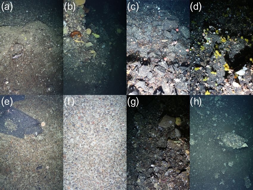
612                                     A. Purser et al.: Seafloor imagery from the northern Weddell Sea and Powell Basin

Figure 3. Typical seafloor images collected from each of the OFOBS surveys made of the Weddell Sea seafloor during RV Polarstern
cruise PS118. (a) Station PS118_6, hotkey_2019_03_06 at 05_07_31. (b) Station PS118_7, hotkey_2019_03_06 at 19_36_28. (c) Station
PS118_8, hotkey_2019_03_11 at 14_33_24. (d) Station PS118_9, timer_2019_03_12 at 06_01_06. (e) Station PS118_11, timer_2019_03_13
at 20_14_04. (f) Station PS118_11, timer_2019_03_13 at 22_18_47. (g) Station PS118_12, timer_2019_03_15 at 01_29_36. (h) Station
PS118_38, hotkey_2019_03_23 at 06_27_00. All images are presented here and in the dataset with no manipulation or colour correction.

tem (iSiTEC, Canon EOS 5D Mark III) with an automated               ensures that each image recorded has three red dots near
timer (for the majority of images, these were taken with a          the centre of the image, each spaced by 50 cm. These dots
frequency of about one image every 20 s). Additional im-            can be used in subsequent analysis to determine accurately
ages taken at the discretion of the operator. These two im-         the area covered by a particular image. Throughout PS118
age categories are distinguished in the dataset as “hotkey”         the OFOBS was deployed approximately 1.5–2 m above the
and “timer” images – designations automatically incorpo-            seafloor, giving a coverage within each collected image of
rated into the timestamped filenames. Hotkey images were            4–6 m2 . Illumination of the seafloor was provided by four
commonly taken on the first observation of a particular fauna       downward-facing SeaLight Sphere 3150 LED lights posi-
species or to record a feature of interest, such as a whale         tioned in the corners of the main OFOBS frame, with two
fall or interesting geological structure. No processing stages      additional strobe lights (iSiTEC UW-Blitz 250, through the
were applied to the maximum-resolution .jpeg data collected         lens (TTL) driven) firing concurrently with image collection.
from the camera, which are provided here at the maximum             Throughout all deployments, HD (high-definition) video data
acquired resolution.                                                were recorded by the OFOBS for the duration of each dive
   Throughout all of these deployments the OFOS and                 with an HD video recorder (iSiTEC, Sony FCB-H11) (Purser
OFOBS systems were equipped with three red sizing lasers            et al., 2018).
(FLEXPOINT) (Purser et al., 2018; Purser and Sablotny,
2020), arrayed in an equilateral triangle with 50 cm spac-
ing around the still-image camera housing. This laser array

Earth Syst. Sci. Data, 13, 609–615, 2021                                              https://doi.org/10.5194/essd-13-609-2021
A. Purser et al.: Seafloor imagery from the northern Weddell Sea and Powell Basin                                                 613

Figure 4. Typical seafloor and cliff escarpment images collected during OFOBS surveys of the Powell Basin flanks during RV Po-
larstern cruise PS118. (a) Station PS118_39, hotkey_2019_03_23 at 23_ 21_46. (b) Station PS118_39, timer_2019_03_25 at 18_50_09.
(c) Station PS118_69, hotkey_2019_03_31 at 12_20_55. (d) Station PS118_69, hotkey_2019_03_31 at 14_10_56. (e) Station PS118_77,
timer_2019_04_01 at 20_39_51. (f) Station PS118_77, timer_2019_04_01 at 20_11_32. (g) Station PS118_81, timer_2019_04_04 at
00_25_31. (h) Station PS118_81, timer_2019_04_04 at 02_27_33. All images are presented here and in the dataset with no manipulation or
colour correction.

2.2     Field sampling                                               Three of these deployments, PS118/39-1, PS118/69-1 and
                                                                     PS118/81-1, benefitted from the equipping of the OFOBS
2.2.1    Weddell Sea sampling                                        sled with a forward-looking sonar (Purser et al., 2018). This
OFOBS surveys were carried out in a roughly south–north              sensor allowed for the OFOBS to be used over very steep
transect from the Weddell Sea continental shelf of the               terrain with minimum risk, by giving advance warning of
Antarctic Peninsula to the northern Powell Basin. In to-             any hard structures ∼ 30 m ahead of the sled. The majority
tal, seven OFOBS deployments were made between 65 and                of towed sleds, such as the OFOS, are less capable in high-
62◦ S (Table 1 and Fig. 2). With the exception of an OFOBS           relief regions, where snagging on tall structures such as cliffs
deployment across the Nachtigaller Shoal (Dorschel et al.,           or vent structures can occur. With the OFOBS, the ∼ 30 m
2014) (station PS118/11-2), the seafloor in these regions was        warning of approach is sufficient to allow the operators to
observed to be predominantly made up of soft material with           commence winching of the system in good time to minimise
occasional drop stones present (Fig. 3).                             the risk of impact of the sled with the seafloor whilst still col-
                                                                     lecting usable image data. These datasets each cover many
                                                                     hundreds of metres of the Powell Basin flank walls, visually
2.2.2    Powell Basin sampling                                       surveying these traditionally difficult-to-investigate regions
                                                                     of seafloor (Fig. 4).
Four successful OFOBS deployments were made on the
flanks and rim of the Powell Basin (Table 1 and Fig. 2).

https://doi.org/10.5194/essd-13-609-2021                                                Earth Syst. Sci. Data, 13, 609–615, 2021
614 A. Purser et al.: Seafloor imagery from the northern Weddell Sea and Powell Basin
3 Data availability Dorschel, B.: Links to master tracks in different resolutions of PO-
LARSTERN cruise PS118, Punta Arenas – Punta Arenas, 2019-
All seafloor images collected with the OFOBS system are 02-09–2019-04-08, Alfred Wegener Institute, Helmholtz Cen-
available from the data publisher PANGAEA. No prepro- tre for Polar and Marine Research, Bremerhaven, PANGAEA,
cessing or processing stages were applied prior to upload, https://doi.org/10.1594/PANGAEA.901319, 2019a.
with no colour correction or light-vignetting algorithms Dorschel, B.: The Expedition PS118 of the Research Vessel PO-
LARSTERN to the Weddell Sea in 2019, Berichte Zur Polar-
applied. These images are provided with georeferenced po-
Meeresforsch. Rep. Polar Mar. Res., available at: https://epic.
sitions for each image, as derived from the Posidonia system
awi.de/id/eprint/50139/ (last access: 5 February 2020), 2019b.
(https://doi.org/10.1594/PANGAEA.911904; Purser et al., Dorschel, B., Gutt, J., Piepenburg, D., Schröder, M., and Arndt,
2020). The full cruise track is also available via PANGAEA J. E.: The influence of the geomorphological and sedimento-
(https://doi.org/10.1594/PANGAEA.901319; Dorschel, logical settings on the distribution of epibenthic assemblages
2019a) with information on additional environmental and on a flat topped hill on the over-deepened shelf of the western
scientific data collected during the cruise given in the PS118 Weddell Sea (Southern Ocean), Biogeosciences, 11, 3797–3817,
cruise report (Dorschel, 2019b). Video data collected via the https://doi.org/10.5194/bg-11-3797-2014, 2014.
OFOBS system are available from the authors on request. Fillinger, L., Janussen, D., Lundälv, T., and Richter, C.:
In addition to the image data presented in this paper, the Rapid Glass Sponge Expansion after Climate-Induced
multibeam data concurrently collected by the OFOBS device Antarctic Ice Shelf Collapse, Curr. Biol., 23, 1330–1334,
https://doi.org/10.1016/j.cub.2013.05.051, 2013.
has also been uploaded to PANGAEA and will be available
Griffiths, H. J., Meijers, A. J. S., and Bracegirdle, T. J.:
from April 2021 for open-access download or on request
More losers than winners in a century of future Southern
from the authors. Ocean seafloor warming, Nat. Clim. Change, 7, 749–754,
https://doi.org/10.1038/nclimate3377, 2017.
Gutt, J., Alvaro, M. C., Barco, A., Böhmer, A., Bracher, A.,
Author contributions. AP applied for the secondary user time for David, B., De Ridder, C., Dorschel, B., Eléaume, M., Janussen,
the PS118 cruise, conceived of the investigation and ran the data D., Kersken, D., López-González, P. J., Martínez-Baraldés, I.,
collection campaign. BD was the chief scientist for the PS118 ex- Schröder, M., Segelken-Voigt, A., and Teixidó, N.: Macroepiben-
pedition. SD, LH, HS, HG and AN helped run the OFOBS platform. thic communities at the tip of the Antarctic Peninsula, an ecolog-
AP, HG, KJ, DP, CR and BD determined sampling strategies for the ical survey at different spatial scales, Polar Biol., 39, 829–849,
OFOBS and aided in data collection. AP prepared the paper with https://doi.org/10.1007/s00300-015-1797-6, 2016.
contributions from all co-authors. Gutt, J., Arndt, J., Kraan, C., Dorschel, B., Schröder, M., Bracher,
A., and Piepenburg, D.: Benthic communities and their drivers: A
spatial analysis off the Antarctic Peninsula, Limnol. Oceanogr.,
Competing interests. The authors declare that they have no con- 64, 2341–2357, https://doi.org/10.1002/lno.11187, 2019.
flict of interest. Han, H., Lee, S., Kim, J.-I., Kim, S. H., and Kim, H.:
Changes in a Giant Iceberg Created from the Collapse of
the Larsen C Ice Shelf, Antarctic Peninsula, Derived from
Acknowledgements. The captain and crew of RV Polarstern ex- Sentinel-1 and CryoSat-2 Data, Remote Sens., 11, 404,
pedition PS118 are thanked for their support and interest in the https://doi.org/10.3390/rs11040404, 2019.
OFOBS deployments conducted during the cruise. Ulrich Hoge is Piepenburg, D., Buschmann, A., Driemel, A., Grobe, H., Gutt, J.,
thanked for his assistance in installing the OFOBS system prior to Schumacher, S., Segelken-Voigt, A., and Sieger, R.: Seabed im-
cruise commencement. ages from Southern Ocean shelf regions off the northern Antarc-
tic Peninsula and in the southeastern Weddell Sea, Earth Syst.
Sci. Data, 9, 461–469, https://doi.org/10.5194/essd-9-461-2017,
Review statement. This paper was edited by David Carlson and 2017.
reviewed by Katrien Van Landeghem and one anonymous referee. Purser, A. and Sablotny, B.: Hochauflösende Fotos bei absoluter
Dunkelheit, Photonics News, 88, 10–11, 2020.
Purser, A., Marcon, Y., Dreutter, S., Hoge, U., Sablotny, B.,
Hehemann, L., Lemburg, J., Dorschel, B., Biebow, H., and
References Boetius, A.: Ocean Floor Observation and Bathymetry Sys-
tem (OFOBS): A new Towed Camera/Sonar System for
Barnes, D. K. A. and Tarling, G. A.: Polar oceans Deep-Sea Habitat Surveys, IEEE J. Ocean. Eng., 44, 87–99,
in a changing climate, Curr. Biol., 27, R454–R460, https://doi.org/10.1109/JOE.2018.2794095, 2018.
https://doi.org/10.1016/j.cub.2017.01.045, 2017. Purser, A., Hehemann, L., Dreutter, S., Dorschel, B., and Nord-
Chaabani, S., López-González, P. J., Casado-Amezú, P., Pehlke, hausen, A.: OFOBS Seafloor images from the Antarctic Penin-
H., Weber, L., Martínez-Baraldés, I., and Jerosch, K.: Eco- sula and Powell Basin, collected during RV POLARSTERN
logical niche modelling of cold-water corals in the Southern cruise PS118, Alfred Wegener Institute, Helmholtz Centre
Ocean (N Antarctic), present distribution and future projections for Polar and Marine Research, Bremerhaven, PANGAEA,
due to temperature changes, Mar. Ecol. Prog. Ser., 628, 73–93, https://doi.org/10.1594/PANGAEA.911904, 2020.
https://doi.org/10.3354/meps13085, 2019.
Earth Syst. Sci. Data, 13, 609–615, 2021 https://doi.org/10.5194/essd-13-609-2021A. Purser et al.: Seafloor imagery from the northern Weddell Sea and Powell Basin 615 Rott, H., Skvarca, P., and Nagler, T.: Rapid Collapse of North- Schröder, M., Ryan, S., and Wisotzki, A.: Physical oceanog- ern Larsen Ice Shelf, Antarctica, Science, 271, 788–792, raphy during POLARSTERN cruise PS96 (ANT-XXXI/2 https://doi.org/10.1126/science.271.5250.788, 1996. FROSN), Alfred Wegener Institute, Helmholtz Centre for Scambos, T., Hulbe, C., and Fahnestock, M.: Climate-Induced Ice Polar and Marine Research, Bremerhaven, PANGAEA, Shelf Disintegration in the Antarctic Peninsula, in: Antarctic https://doi.org/10.1594/PANGAEA.859040, 2016. Peninsula Climate Variability: Historical and Paleoenvironmen- Shepherd, A., Wingham, D., Payne, T., and Skvarca, P.: Larsen tal Perspectives, American Geophysical Union (AGU), 79–92, Ice Shelf Has Progressively Thinned, Science, 302, 856–859, available at: https://agupubs.onlinelibrary.wiley.com/doi/abs/10. https://doi.org/10.1126/science.1089768, 2003. 1029/AR079p0079 (last access: 10 February 2021), 2013. Skvarca, P.: Fast recession of the northern Larsen Ice Shelf Schoening, T., Purser, A., Langenkämper, D., Suck, I., Tay- monitored by space images, Ann. Glaciol., 17, 317–321, lor, J., Cuvelier, D., Lins, L., Simon-Lledó, E., Marcon, Y., https://doi.org/10.3189/S0260305500013033, 1993. Jones, D. O. B., Nattkemper, T., Köser, K., Zurowietz, M., Greinert, J., and Gomes-Pereira, J.: Megafauna community as- sessment of polymetallic-nodule fields with cameras: platform and methodology comparison, Biogeosciences, 17, 3115–3133, https://doi.org/10.5194/bg-17-3115-2020, 2020. https://doi.org/10.5194/essd-13-609-2021 Earth Syst. Sci. Data, 13, 609–615, 2021
You can also read