Open Space and Recreation - Milford CT
←
→
Page content transcription
If your browser does not render page correctly, please read the page content below
Open Space and Recreation
As a fully developed 1st ring suburb with concentrated urban neighborhoods, open spaces are important to maintaining the balance
necessary for the City’s high quality of life. Information for this Chapter was gathered through meeting with the Mayor’s Open
Space Advisory Committee, the Conservation Commission, the Environmental Concerns Coalition, and the Recreation Department.
Although historically open space has been a discussion exclusive to the “open space” boards, this plan recognizes that maintenance,
improvements, and ongoing management of City‐owned recreation properties ‐ including passive recreation properties ‐ is the
jurisdiction of the Park, Beach, and Recreation Commission and their input is integral to long‐term planning for these sites. This
Chapter is divided into two sections: Passive Open Space and Active Recreation. Discussion of farmland preservation and potential
expansion of the City’s community garden program can be found in the Agriculture Chapter and Beaches, shoreline protection and
coastal access has been moved to the Chapter on Long Island Sound.
The City’s open spaces are diverse and fall into a wide category of uses –
• active programmed parks such as ball fields, basketball and tennis courts,
• passive, yet maintained open spaces such as the Green, duck ponds with limited programming,
• natural sites with passive activities such as hiking trails, including the City’s many public beaches and tidal marshland areas.
Passive Open Space
The goal of this section is three fold ‐ first to recognize the City’s strengths in
its current open space corridors, outline areas of potential expansion or
acquisition as ways of improving these corridors, and lastly to provide a
framework for better management of these properties.
Since the last Plan of Conservation and Development was published in 2002,
the City has been successful in purchasing many open space properties that
protect natural resources and expand existing open space properties including:
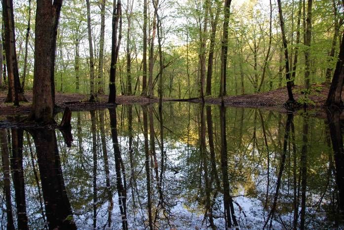
• Solomon Woods (shown left)
Plan of Conservation and Development Page 23 December, 2012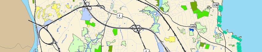
•   Former Regional Water Authority site on Burnt Plains Road
   •   Oronoque Road parcel adjacent to River Crest Farm

Passive Open Space can be defined as meeting the following categories:
Type                Description                                        Properties
Perceived Open      Land currently free from development, but not      Vacant properties both publically and privately held,
Space               restricted from future development. No public      but not deed restricted.
                    use.
Naturalized Open    Preserved in perpetuity by deed restriction or     Wilcox Park, Wheeler Wildlife Area/Audubon Coastal
Space               other mechanism such as approval by the            Center, Mondo Ponds, Red Root Lane Nature Trails,
                    Planning Zoning Board as required open space.      Milford Land Conservation Trust properties, Solomon
                    In Milford, public use of these areas is usually   Property, Heritage Sound berm, open space
                    allowed, but may not be accessible.                dedications as part of subdivisions, and conservation
                                                                       easements.
Managed Public      Maintained lands presently used for public         Town Green/Arboretum, Fowler Field, portions of
Open Spaces         purpose.                                           Eisenhower Park, Upper and Lower
(Publicly held)                                                        Duckponds/Wepawaug River. Also includes coastal
                                                                       properties such as Walnut Beach, Silver Sands State
                                                                       Park, and other coastal access points. Non‐
                                                                       programmed City Parks.
Managed Open        Land actively managed that leaves the land         Private golf courses, cemeteries, and utility company
Space (Privately    open, but not specifically protected from future lands.
Held)               development.

As with the last plan, a high priority for conservation is given to those sites containing resources that are unique to Milford or
significant or fragile natural environments that require additional protection. The State has categorized some of these areas through
their Natural Diversity Database delineations (shown on attached map.) The Natural Diversity Data Base maps represent
approximate locations (“blobs”) of endangered, threatened and special concern species and significant natural communities. The

Plan of Conservation and Development                          Page 24                                               December, 2012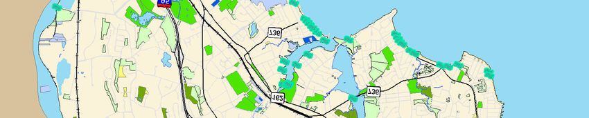
Classifications of Open Space
                                                                  Plan of Conservation and Development
                                                                                   City of Milford - 2012
                                                                  GIS maps provided by MIS Department

                                                                      95
                            121                                       §
                                                                      ¦
                                                                      ¨
                            ³
           £15
           ¢
                                                  £1
                                                  ¢

                                                                                 162

                                                                                 ³
                                   £ 1
                                   ¢
                                                                                         736

                                                                                         ³
                                         162                    736
                                         ³

                                                                ³

                                         737
                                         ³

                 95
                 §
                 ¦
                 ¨
                      162
                      ³

                                                                      Legend
                                                            Assessed as Open Space
                                                            Zoned As Open Space
                                                            Land Trust Parcels
                                                            DRAFT Deed Restricted Open Space
                                                            Town Owned Property
                                                            State Of CT Property
                                                            Federal Property

                                  Path: \\Mgis\gis\Projects\POCD\MXDs\OpenSpace.mxd            ±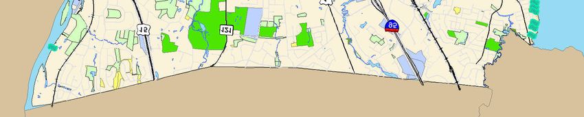
Plan of Conservation and Development Page 26 December, 2012

Milford Natural Diversity Database

                                                       Legend
                                                            Natural Diversity Area
                                                       Critical Habitat
                                                       Estuarine
                                                            Estuarine, Beachshore, B
                                                            Estuarine, Intertidal Marsh, IM
                                                       Terrestrial Forested
                                                            Terrestrial Forested, Coastal Woodland/Shrubland, CWS

                             0           4,500          9,000                                 18,000 Feet

              Date: 8/3/2012

              NDDB data (June 2012) from CT Department of Energy and Environmental Protection (DEEP)
              http://www.ct.gov/dep/cwp/view.asp?a=2702&q=323464&depNav_GID=1628

              This map was produced from the City of Milford Geographic Information System.
              The City expressly disclaims any liability that may result from the use of this map.
              This map is not a survey and is subject to any changes an actual land survey discloses.
general locations of species and natural communities depicted on the maps are based on data collected over the years by DEEP staff,
scientists, conservation groups, and landowners. The maps are intended to be a pre‐screening tool to identify potential impacts to
state‐listed species and to identify areas of potential conservation concern. The DEEP updates the maps periodically (every 6 months
or so) and new information is continually being added to the database.1

Greenways and Greenbelts
As Milford is a coastal community at the base of several watersheds, the City’s greenways are defined by waterways.
Nine (9) areas were targeted in the City’s last two plans (1973 and 2002) for preservation and conservation. These areas continue to
have lasting importance as greenway corridors targeted for preservation, although some have been consolidated in this Plan
resulting in just seven (7) combined resource/greenway corridors. Greenbelts are defined as the entire preserved corridor left in its
natural state for habitat preservation and greenways are paths or connected access points that provide public access which can be
located within these corridors. Where possible, greenways should be identified within the greenbelt areas to provide better passive
recreation oversight and so that Milford’s citizens can experience these unique natural environments.

    1. Wepawaug River and Watershed Corridor – The City’s centrally located river system extends from the Orange Border and
       drains into Milford Harbor. Several important sections are already preserved through municipal purchase and ownership
       including Solomon Woods and Eisenhower Park. The corridor should be expanded to provide additional floodway/flood plain
       protection. Additional conservation easements or purchases along private property could be possible.
    2. Housatonic River Corridor/Lower Turkey Hill Brook Greenbelt – The Housatonic River defines the City’s westerly border, but
       there are limited public access points to this water body and land along the river is predominantly privately held. The mouth
       of the river is protected as part of the Stewart B. McKinney National Wildlife Refuge designated by congress in 1972. This
       area is currently managed by collaboration between the US Fish and Wildlife Service, the State DEEP, and the Audubon
       Coastal Center and is a primary area of concern for the endangered piping plover. The next access point is the Housatonic
       River Overlook Park in Devon which has a wonderful view of the 1920s Washington Bridge, followed by the State boat ramp
       under I‐95 (Moses Wheeler Bridge), City fishing area and boat launch at Caswell Street, and finally a river overlook in the
       Great River Golf Course that was required as part of their Coastal Site Plan review. Through the Sikorsky Bridge replacement

1
 Excerpted from the State Department of Energy and Environmental Protection website ‐
http://www.ct.gov/dep/cwp/view.asp?a=2702&q=323464&depNav_GID=1628

Plan of Conservation and Development                                   Page 28                                       December, 2012
Open Space and Recreation
As a fully developed 1st ring suburb with concentrated urban neighborhoods, open spaces are important to maintaining the balance
necessary for the City’s high quality of life. Information for this Chapter was gathered through meeting with the Mayor’s Open
Space Advisory Committee, the Conservation Commission, the Environmental Concerns Coalition, and the Recreation Department.
Although historically open space has been a discussion exclusive to the “open space” boards, this plan recognizes that maintenance,
improvements, and ongoing management of City‐owned recreation properties ‐ including passive recreation properties ‐ is the
jurisdiction of the Park, Beach, and Recreation Commission and their input is integral to long‐term planning for these sites. This
Chapter is divided into two sections: Passive Open Space and Active Recreation. Discussion of farmland preservation and potential
expansion of the City’s community garden program can be found in the Agriculture Chapter and Beaches, shoreline protection and
coastal access has been moved to the Chapter on Long Island Sound.

The City’s open spaces are diverse and fall into a wide category of uses –
   • active programmed parks such as ball fields, basketball and tennis courts,
   • passive, yet maintained open spaces such as the Green, duck ponds with limited programming,
   • natural sites with passive activities such as hiking trails, including the City’s many public beaches and tidal marshland areas.

Passive Open Space
                                                      The goal of this section is three fold ‐ first to recognize the City’s strengths in
                                                      its current open space corridors, outline areas of potential expansion or
                                                      acquisition as ways of improving these corridors, and lastly to provide a
                                                      framework for better management of these properties.

                                                      Since the last Plan of Conservation and Development was published in 2002,
                                                      the City has been successful in purchasing many open space properties that
                                                      protect natural resources and expand existing open space properties including:

                                                          •   Solomon Woods (shown left)

Plan of Conservation and Development                           Page 23                                                    December, 2012
• Former Regional Water Authority site on Burnt Plains Road
• Oronoque Road parcel adjacent to River Crest Farm
Passive Open Space can be defined as meeting the following categories:
Type Description Properties
Perceived Open Land currently free from development, but not Vacant properties both publically and privately held,
Space restricted from future development. No public but not deed restricted.
use.
Naturalized Open Preserved in perpetuity by deed restriction or Wilcox Park, Wheeler Wildlife Area/Audubon Coastal
Space other mechanism such as approval by the Center, Mondo Ponds, Red Root Lane Nature Trails,
Planning Zoning Board as required open space. Milford Land Conservation Trust properties, Solomon
In Milford, public use of these areas is usually Property, Heritage Sound berm, open space
allowed, but may not be accessible. dedications as part of subdivisions, and conservation
easements.
Managed Public Maintained lands presently used for public Town Green/Arboretum, Fowler Field, portions of
Open Spaces purpose. Eisenhower Park, Upper and Lower
(Publicly held) Duckponds/Wepawaug River. Also includes coastal
properties such as Walnut Beach, Silver Sands State
Park, and other coastal access points. Non‐
programmed City Parks.
Managed Open Land actively managed that leaves the land Private golf courses, cemeteries, and utility company
Space (Privately open, but not specifically protected from future lands.
Held) development.
As with the last plan, a high priority for conservation is given to those sites containing resources that are unique to Milford or
significant or fragile natural environments that require additional protection. The State has categorized some of these areas through
their Natural Diversity Database delineations (shown on attached map.) The Natural Diversity Data Base maps represent
approximate locations (“blobs”) of endangered, threatened and special concern species and significant natural communities. The
Plan of Conservation and Development Page 24 December, 2012Classifications of Open Space
Plan of Conservation and Development
City of Milford - 2012
GIS maps provided by MIS Department
95
121 §
¦
¨
³
£15
¢
£1
¢
162
³
£ 1
¢
736
³
162 736
³
³
737
³
95
§
¦
¨
162
³
Legend
Assessed as Open Space
Zoned As Open Space
Land Trust Parcels
DRAFT Deed Restricted Open Space
Town Owned Property
State Of CT Property
Federal Property
Path: \\Mgis\gis\Projects\POCD\MXDs\OpenSpace.mxd ±Plan of Conservation and Development Page 26 December, 2012
Milford Natural Diversity Database

                                                       Legend
                                                            Natural Diversity Area
                                                       Critical Habitat
                                                       Estuarine
                                                            Estuarine, Beachshore, B
                                                            Estuarine, Intertidal Marsh, IM
                                                       Terrestrial Forested
                                                            Terrestrial Forested, Coastal Woodland/Shrubland, CWS

                             0           4,500          9,000                                 18,000 Feet

              Date: 8/3/2012

              NDDB data (June 2012) from CT Department of Energy and Environmental Protection (DEEP)
              http://www.ct.gov/dep/cwp/view.asp?a=2702&q=323464&depNav_GID=1628

              This map was produced from the City of Milford Geographic Information System.
              The City expressly disclaims any liability that may result from the use of this map.
              This map is not a survey and is subject to any changes an actual land survey discloses.
project, the State incorporated a pedestrian and bike path over the Housatonic River along Route 15, which has limited
parking on the Milford side. The Lower Turkey Hill Brook greenbelt identified in the prior two plans has been extensively
subdivided with a few wetland parcels donated and deed‐restricted, but no additional land available for preservation or
purchase. As such, this section is now incorporated with the Housatonic River Greenbelt.
3. Beaver Brook Corridor – This corridor starts with the open space area at Lexington Green and traverses several
neighborhoods through City and private open space leading to the Mondo Pond area behind JFK Elementary School and
includes the privately‐owned, but deed restricted Beaver Brook trails off West Avenue that was recently damaged by fire. It
should be a high priority to reconstruct the boardwalk that crossed these wetlands so the public can continue to enjoy this
unique natural environment. The Beaver Brook watershed continues to the former Regional Water Authority Reservoir
adjacent to Jonathan Law High School (north and south of Bridgeport Avenue/Route 1) and extends through the Devon
neighborhood into Long Island Sound.
4. Long Island Sound Beachfront/Tidal Marshland Protection – The last POCD recommends purchasing properties to extend
existing public holdings to protect scenic view areas with fishing access. While acquisitions would accomplish this goal, the
strongest argument for purchasing lands along Long Island Sound Beachfront and Tidal Marshlands is increased flood
protection and adaptation to anticipated sea level rise.
5. Stubby Plain Brook/Indian River Corridor – The Indian River begins near the border with Orange and continues south parallel
to the Boston Post Road until it drains into Gulf Pond. Along the way, the Clark Pond fish ladder allows alewife populations
to breed upstream and the entire corridor serves as an important bird habitat corridor with several Osprey platforms in place
in the tidal marshland areas. Since the last POCD, two public access points have been added to the Indian River greenbelt ‐ a
public access walkway behind the Milford Crossing shopping Center and a conservation easement to the rear of an Old Gate
Lane property. In 2011, Yale interns from the School of Forestry and Environmental Studies studied the Indian River Corridor
and recommended better maintenance for the Milford Crossing trail and identifying a connection through other private
properties that lead to the Clark Fish ladder. Their analysis showed that much of this corridor is privately owned (both
residentially and commercial) where conservations easements might be possible. As most of the southerly portion of the
corridor is tidal wetlands – greenway access is difficult, but greenbelt protection should be a high priority given its sensitive
environmental features.
6. Calf Pen Meadow Creek Corridor – Starting at the open space area at Settlers Ridge, the Calf Pen Meadow Creek corridor
extends westerly to its outfall to the tidal marshlands on Melba Street to Long Island Sound. It winds behind both Foran High
Plan of Conservation and Development Page 29 December, 2012Milford Open Space Corridors
Wepawaug River Watershed
Stubby Plain Brook/Indian River South Central Watershed/Farley Brook/Oyster River
Wepawaug River Legend
Open Space Corridors
Beaver Brook
Housatonic River/Lower Turkey Hill Brook
Long Island Sound Beachfront
South Central Watershed/Calf Pen Meadow Creek
Housatonic River/ South Central Watershed/Farley Brook/Oyster River
Lower Turkey Hill Brook Stubby Plain Brook/Indian River
Wepawaug River
Wepawaug River Watershed
Beaver Brook
South Central Watershed/Calf Pen Meadow Creek
0 4,450 8,900 17,800 Feet
Long Island Sound Beachfront
Date: 8/7/2012
This map was produced from the City of Milford Geographic Information System.
The City expressly disclaims any liability that may result from the use of this map.
This map is not a survey and is subject to any changes an actual land survey discloses.School and Calf Pen Meadow Elementary School. As indicated in the prior POCD, the adjacent location to both education
facilities lends itself to an access point with educational installations. Preservation for vista and habitat protection only.
Public access is and should continue to be limited.
7. Oyster River and Farley Brook Corridor – These corridors are characterized by tidal marshlands, however the headwaters for
this system start in Bethany. There are significant water quality issues for these marshlands that will addressed by the
pending sewer infrastructure expansion. A Scenic Vista may be possible if parcels can be connected between New Haven
Avenue and Anderson Avenue that used to be prior trolley right of way. Utilizing state funds and partnering with West
Haven, a phragmites control project has reintroduced native species.
It should be a high priority to acquire properties where possible within these seven (7) designated greenbelt/greenway areas and to
locate public access point and greenways where possible.
Preservation and Acquisition
In purchasing prior open space properties, the City has relied heavily on the State DEEP Open Space Grant program. The program
has specific criteria for land that may be purchased as part of the program. Properties need to meet one of the following open space
characteristics:
Land that is:
1) valuable for recreation, forestry, fishing, conservation of wildlife or natural resources;
2) a prime natural feature of the state's landscape;
3) habitat for native plant or animal species listed as threatened, endangered or of special concern;
4) a relatively undisturbed, outstanding example of an uncommon native ecological community;
5) important for enhancing and conserving water quality;
6) valuable for preserving local agricultural heritage; or
7) eligible to be classified as Class I or Class II watershed land.
The City has additional open space acquisition goals that include:
1. Areas adjacent to City‐owned, State or Milford Conservation Land Trust properties open space properties.
2. Areas adjacent to other open space parcels that could provide connected passive recreation opportunities.
Plan of Conservation and Development Page 31 December, 20123. Areas within the 100‐year floodplain or the floodway.
4. Areas within the seven (7) greenbelts/greenways identified in the POCD.
The City should continue to apply for the DEEP Open Space grant program and other grant programs if property becomes available
that meets the State or Local criteria as identified in this section. In addition to utilizing DEEP grant funds, the City can also purchase
property through a local Open Space fund. The Open Space fund’s revenues are generated through the Planning & Zoning Board’s
subdivision approval process. Developers have the option of paying into the Open Space fund instead in lieu of providing physical
open space as part of a subdivision development.
Open space Tax Credit
Private Open Space Land can also be deed restricted or encumbered with a conservation easement. Public Act 490 provides the City
with an additional tool for defining Open Space and adopting a local open space tax credit as a means of preservation. The City does
not currently participate in the PA 490 Open Space tax credit, but does participate in the tax credit for agriculture.
PA 490 for Open Space requires:
o Land must be recommended for preservation as open space in the town’s Plan of Conservation and Development by
the town’s Planning Commission
o Geographic areas designated as being recommended for open space in the Plan of Conservation and Development
must be approved by the legislative authority within the municipality.
o The municipality adopts an Open Space Assessment Ordinance which stipulates the qualification criteria for the open
space classification in that municipality. The criteria establish the minimum acreage as well as requiring that the land
be completely unimproved and undeveloped. For example, the City of Milford is fairly urbanized and might want to
establish a minimum 1 acre whereas more rural communities might designate a 50 acre minimum.
Additional information can be found on the Connecticut Farm Bureau Associations website at:
http://www.cfba.org/images/resources/complete_490guide_cfba.pdf
Open Space Property Maintenance
Plan of Conservation and Development Page 32 December, 2012The Mayor’s Open Space Advisory Committee, the Conservation Commission, Environmental Concerns Coalition (ECC), as well as
other constituents have expressed concern that although the City has success at purchasing open space properties – that the
management and oversight of these spaces has been limited ‐ leading to irreparable damage by motorized vehicles such as ATVs,
motorbikes, and other off‐road vehicles.
Land Management goals must include:
• Systematic inventory and categorization of open space properties and their natural feature values (mapping, size, resources,
uses allowed and restricted).
• Property Management Plan including timelines, protocols, and identifying resources (staff and equipment) needed for
adequate property oversight.
• Property Improvement Plan including installation of signage, trail blazes, property delineations such as property postings and
fencing where appropriate, educational signage, parking areas where possible.
• Restoration Plans for degraded open space properties for invasive species removal, trail maintenance, and wetlands and
habitat restoration as appropriate.
• Property maps available to public that clearly show allowed and prohibited uses, access and restricted areas, trail heads,
trails, and amenities such as parking, restrooms, etc. (such as the Regional Water Authority recreation permit holders maps)
• Coordinate with local schools and other organizations (Boy Scouts, Girl Scouts, Conservation organizations, etc.) to provide
educational opportunities that reinforce the importance of natural environments to the City’s future generations.
• Must have staff resources to coordinate volunteer efforts on Open Space properties such a trail maintenance and invasive
species removal.
The City must make it a high priority to better protect its open space properties and protected natural environments. The City needs
to locate funds or designate funding to adequate provide oversight of its open space properties to ensure that they are not only safe
for the general public, but their unique natural features are protected and remain intact.
Zoning Map Open Space Designations
As indicated in the last POCD, the City’s Open Space parcels whether State‐ and Federally‐owned, City‐owned, deed restricted,
Milford Conservation Land Trust, or subdivision set‐aside ‐ need to be designated as Open Space on the Zoning Map to clearly show
its conservation status. Following the POCD adoption, this project should be a high priority for Planning & Zoning and GIS staff and
Plan of Conservation and Development Page 33 December, 2012the Planning and Zoning Board for adoption. Specifically, mixed City‐owned properties such as Fowler Field, need to have its naturalized portions such as Wilcox Park shown as Open Space to ensure their protection, and to better identify future open space linkages and areas to target for acquisition. Active Recreation The City’s Park, Beach, and Recreation Commission in conjunction with the Recreation Department and Public Works, oversees a diverse portfolio of properties ‐ from a public 9‐hole golf course, baseball and softball fields, soccer fields, basketball and tennis courts, a skate park, multi‐purpose gymnasiums (located both in public buildings and schools), the City’s public beaches, fishing piers, and boat and canoe launches, playgrounds, bocce courts, swimming pools, and the City’s dog park, community garden, and the equestrian ring at Eisenhower Park. The Park, Beach and Recreation Commission also have jurisdiction over some of the City’s open space properties like Eisenhower Park, the Boardwalk at Walnut Beach, Beaver Brook Nature Trails, Mondo Pond Nature Trails, Red Root Natural Trail, and the Solomon Woods site. As indicated in the Land Use table, the City has 125 park parcels equaling approximately 1,318 acres or 11.38% of Milford’s land area. Since the last POCD, the City has also acquired additional property adjacent to the YMCA on Orange Avenue and a parcel adjacent to River Crest Farms on Oronoque Road. The Orange Avenue parcel is intended for additional playing fields, but the budget for improvements has not yet been allocated. The Oronoque Road site has not yet been programmed. Eisenhower Park Plan Improvements Since the last POCD, a large scale planning effort was completed for the City’s largest recreation property – the Eisenhower Park Master Plan was released in 2007. Eisenhower is 333 acres with natural features and habitat, passive and active recreation. The Solomon Woods area (100 acres) is also included as part of the land area of the study. The Park Plan (p. 74‐75) includes the following goals: • Improved pedestrian connectivity and circulation between all Park areas • Ability for the Park to provide Day‐long, four‐season, family oriented activities • Bring back prior activities such as Day Camp venues • Improve existing restroom and other facilities • Enhance and protect the naturalized forest, wetland, and watercourse areas of the Park Plan of Conservation and Development Page 34 December, 2012
City Recreation Facilities Plan of Conservation and Development
City of Milford - 2012
GIS maps provided by MIS Department
s
!
I È
- &
! " n
d Ô&
! " &
" &
" !
"
" &
I
-
"!
& s & "d"&d
""
" n ï
!
" !
&" &
" d
"
"&
& " ! nï
y"
! !
n
d
" ï
!
!
"
ï"
n
!
" &" !y
Ô5
! " ï
"d " I
-
-
I n &
!
" "
&
" & 5
" ï
"
y
! I
- " &
& n d
" "
""!
x
! &
"
d !
"n
&
"
I
- -
I
p &
"ï
&" &"d
" !
d
&
"
"
ï
" "
& x ï
"
" ! ï
!!
l
I
- & ï
"
!n
' I &
- "d d
" "
!
" "
d
" ï
"
&
" 5
!
n
!
"
&
"I Ñ
"!
r
--
I &
"
&"!
Ô ï
! 5
!
p
! d
" l
!
&
" y ï
! !
d
" &
y ""
d
"!
&
n
!
"
ï
"
d
"
!
} ï
"
}
!
±
! ï
"
Legend
! Public Beach Access Recreation Sites
5
" City Indoor Pool ! Ice Pavillion
' n School
!
"
Rec Parcels &
" Sports y City Indoor Recreation
! ï
" Private Beach x
! Skate Park
LandTrust Ñ
" Silver Sands Boardwalk } Boating - Car Top
!
Subdivision Open Space - Draft I City Park
- ! State Beach
r
Bocce Court d
" City Playground x Boating - Marina
!
Town Owned Parcels 5 State Park
!
State Land
ï
! City Beach ! City Track
Ô ! Boating - Ramp/Car-top !
p ± State Wildlife Area
Federal Land l City Fishing Pier
! È Horse Ring
!
s Public Golf Course
!You can also read