MethaneSAT: Putting the Brakes on Climate Change
←
→
Page content transcription
If your browser does not render page correctly, please read the page content below
MethaneSAT: Putting the Brakes on Climate Change
Key Technical Considerations
May 2019

What makes MethaneSAT special
MethaneSAT, an affiliate of Environmental Defense Fund (EDF), is building a satellite that will
provide data to catalyze action that rapidly slows the rate of global warming. It will measure
methane emitted by oil and gas infrastructure worldwide at a level of precision and on a fine
scale never before achieved — and at a fraction of the cost of most space missions. MethaneSAT
will be a key tool in EDF’s strategy to reduce methane emissions from the oil and gas industry by
45% by 2025 and nearly eliminate emissions by 2050.

MethaneSAT will collect information that will be useful and actionable. It will combine the most
advanced instrumentation and groundbreaking data analysis techniques to detect where
methane emissions are coming from and measure how much is being emitted better than any
other satellite, either flying or planned. Detecting even low emission levels is critical because it is
estimated that roughly half of the methane being emitted from oil and gas infrastructure comes
from smaller sources, which are largely unidentified.

Other existing and planned endeavors can either detect methane emissions across large
geographic areas or measure emissions from specific locations. MethaneSAT combines both
capacities and will achieve the degree of precision required to give industry and governments
the confidence they need to act on and enforce the commitments they are already making to
drastically cut methane emissions from their activities.

MethaneSAT has the potential to take a big step forward in making remote sensing of
greenhouse emissions a policy-relevant tool in efforts to develop effective targeted mitigation
strategies.

Providing the precision industry and governments need to act
A high degree of precision and accuracy in our measurements is critical to achieving EDF’s goal
of reducing methane emissions from the oil and gas industry by 45% by 2025 and nearly
eliminating emissions by 2050. Precision enables action by identifying the location/area and
severity of emissions and measuring reductions in emissions from those sources over time.
Accuracy provides industry, governments and the public with the confidence in the data they
need to take action.

MethaneSAT will employ a highly sensitive spectrometer that measures light at the specific
wavelengths where methane absorbs light within the shortwave infrared spectrum. This
approach allows us to detect differences in concentrations of methane as low as 2 parts per
billion (ppb). When combined with groundbreaking new data analytics, MethaneSAT’s small
pixel size (1-2 km2), and wide view path (200 km2) will be able to quantify small emission
sources over large areas that, in the aggregate, are significant sources of methane emissions, but
to date have been undetectable by satellites. In addition, MethaneSAT is able to collect finer
resolution data (with less precision) that will allow larger emissions to be pinpointed to within
400 meters of their source.

For a major oil and gas field, MethaneSAT anticipates being able to quantify the methane
emission rate with an expected 25-35% error. In other words, the emission rate will be no more
than 17.5% above or below the measurement from MethaneSAT on average. This represents a
very high level of accuracy for space-based detection, which will give industry and governments
confidence in the data MethaneSAT provides. This detection threshold is better than what is
necessary to achieve the reductions needed. This confidence is critical to EDF’s ability to turn
MethaneSAT data into action that will result in emissions reductions sufficient to meet our
reduction goals.

Prior to launch, an aircraft based instrument that produces the same type of data as
MethaneSAT will take measurements flying over areas with known methane emission rates to
refine algorithm development and validate the precision and accuracy of MethaneSAT derived
data. It is estimated that this effort, known as MethaneAIR, will shorten the time from initial
data collection to first policy-relevant data product by three to six months.

Tackling the challenge of measuring methane from space
To measure methane emissions from infrastructure at the surface of the earth — from 500 km
above the earth — with the precision needed for industry and governments to take action is an
enormously complex technological challenge. MethaneSAT is designed specifically to address
this challenge.

The first challenge is making sure that the instruments on board the satellite are sensitive
enough, using a very small amount of light, to collect the data needed to do the math that allows
for robust emission quantification. To overcome this challenge, MethaneSAT will use a highly
sensitive spectrometer that can detect the presence of differences in methane concentrations at
very low levels by separating out the narrow bands of wavelength where methane absorbs light
within the shortwave infrared spectrum.

In addition to the challenges of gathering data, the analysis of that data poses perhaps an even
greater challenge. The MethaneSAT mission is developing new, groundbreaking data analytics
to turn raw data into actionable information.

Among the most significant of the data analytics challenges is the need to account for the
scattering and absorption of light by the earth’s surface, and other sources of atmospheric
interference such as aerosols and clouds. Where methane is detected by the satellite instrument
is not where it originated. Measurements from the atmospheric column must be analyzed to
trace the methane detected back to the source and quantify the emission rate. This analysis
requires sophisticated atmospheric transport modeling, based on a state-of-the-art inverse
modeling framework. While such calculations have been carried out for specific areas, they have

                                                2
not been operationally automated such that they become an integral part of the mission and are
applied to all of the data collected.
MethaneSAT will sense plumes of methane — patterns of higher concentrations, created from
point sources or diffuse emissions from larger areas. Inverse modeling factors in wind patterns
and other atmospheric conditions around the methane plume to determine the location and
quantity of point sources or area emissions that would be required to create the methane plume
that was detected by the satellite. In essence, inverse modeling runs the plume back in time to
show the location and magnitude of emissions (leak rates in kg/hr) required to create the
detected plume.
Limiting factors and how they can be addressed
The primary factor limiting the amount and precision of data on variation in methane
concentrations is the amount of light being reflected at the Earth’s surface. The amount of light
that can be detected by the satellite sensor is affected by cloud cover, high latitudes in winter,
and dark surfaces.
1. Cloud cover: Clouds affect all optical and infrared-based remote sensing systems.
MethaneSAT has built forecasting for clouds into its mission planning algorithms that
point the satellite to cloud free areas when possible. To accomplish this, the satellite can
orient up to 45 degrees to the left or right of the flight path (slewing).
The small pixel size will also eliminate the effect of smaller areas of cloud. MethaneSAT
is designed to image global oil and gas operations weekly, more frequently with slewing,
thereby maximizing the opportunity to take measurements when there is no cloud cover
and where significant variability has been observed.
2. High latitudes in winter: MethaneSAT will not make observations over high latitudes,
such as Siberia, during the darkest time in
winter when there is insufficient light to
obtain useful data.
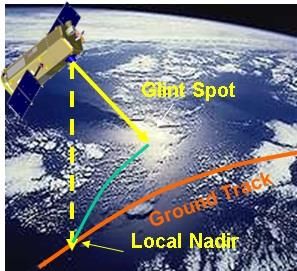
3. Dark surfaces: The majority of the Earth’s
land mass will provide enough reflectance to
support imaging. To address the challenge
posed by surfaces that do not reflect enough
light (primarily over water where offshore
oil/gas production targets are located),
MethaneSAT is using an alternative
measurement that points the sensor to the
bright glint spot over oceans where solar
radiation is directly reflected off the Earth’s
surface (glint mode). To deal with surfaces that do not reflect
enough light, MethaneSAT is using an
alternative measurement method that
points sensors to the glint spot.
3Deploying multiple satellites would increase the frequency of measurements and potentially
overcome some of the challenge posed by cloud cover. However, MethaneSAT does not believe
that cloud cover will limit the ability to create a robust picture of emissions over time across
most regions of the world to an extent that warrants the additional expense of building,
launching and operating multiple satellites.
Similarly, a bigger satellite with larger optics could improve the quality of data collected in
situations with limited light but not enough to warrant the added expense. MethaneSAT
specifications were established specifically to produce the greatest return on investment and
produce the information industry and governments need to take action.
MethaneSAT does not believe that the sensitivity of the satellite’s instrumentation represents a
limiting factor.
How does MethaneSAT fit in the landscape of other methane sensing missions?
There are several efforts in different phases of development. TROPOMI was launched by the
European Space Agency in October 2017 and is providing data. GoSAT2 was recently launched
by the Japan Space Agency. The state of California is working with Planet to build a system. In
the private sector, a company called GHGSat has launched a demonstration methane detection
satellite called Claire. GHGSat plans to launch an upgraded satellite in 2019, with additional
satellites planned in the future. There are also one or two other private sector efforts that are in
nascent stages.
How is the MethaneSAT mission different from other satellites?
Each mission is important and has its own role in the ecosystem of satellites. In fact, the
different missions can complement and strengthen each other. The main differences in satellite
systems come down to scale, precision and data usage.
MethaneSAT is a single satellite with a wide field of view and a high-precision instrument
capable of mapping and quantifying methane emissions from large swaths of land — about 200
km or approximately 125 miles. The satellite’s primary goal is to survey 80% of global oil and gas
operations, measuring aggregate methane emissions from almost all known and previously
unknown sources, as well as identifying the location and size of larger sources.
Data from MethaneSAT will be used to create maps of emissions over areas or regions, along
with the rate of emissions. This information, combined with the International Methane Studies
EDF is conducting separately, will help identify problem emissions that countries or companies
don’t know about or don’t want to publicly acknowledge; define the magnitude of the global
problem; and measure changes in emissions over time.
GHGSat and other satellites like it can examine previously known emissions sources within a
20km or less field of view (target-mode instrument). This information can be used by
government or companies to monitor specific facilities with larger emissions for regulatory
enforcement or operational compliance. By contrast, MethaneSAT is designed to achieve a
comprehensive picture of global emissions and have a 200 km field of view that would only be
4achievable with many satellites with a 20km field of view. However, even with a constellation of
satellites, these data would not include quantification of emissions from diffuse sources, which
account for a large proportion of total anthropogenic emissions. MethaneSAT will provide this
quantification.
TROPOMI is looking at a much larger swath, 2,600 km, and with much coarser spatial
resolution (49 km2 per-pixel area) and higher detection limit than MethaneSAT. This project
seeks to understand very large sources of methane emissions on a global scale. The MethaneSAT
team is working closely with the TROPOMI methane science team to help generate as much
useful data about oil and gas infrastructure as possible, and to integrate any learnings into the
MethaneSAT mission. While data from TROPOMI will start to be made publicly available in
2019, it will not be in a form that is easily actionable without significant additional analysis.
Private satellite systems such as GHGSat do not have plans to release or share data with the
public. Instead, they are going to try to sell the data to oil and gas companies. MethaneSAT’s
data will be made public.
Are there opportunities for collaboration between satellites?
Each project has a distinct role to play that overlaps to some degree with the other. TROPOMI
provides data about areas across the globe with very large emissions. MethaneSAT will provide
ongoing global data that should capture almost all emissions specific to oil and gas operations
(and emissions from agriculture and landfills), allowing us to capture the full measure of the
problem, determine who is responsible and press for action, and assess whether countries and
companies are making progress in reducing emissions over time. GHGSat’s technology can be
used by countries or companies to measure and monitor emissions at specific facilities, for
regulatory enforcement or operational compliance, once those measures are in place.
5Table 1
Regional Source
Local Pixel Swath Detection Quantification
Satellite
Period overpass size width Precision Threshold3
Instrument (Q = 72,000 kg/hr
time (km) (km) (kg/hr) over 300 x 300
km2)
Single pass (~7
MethaneSAT 2021 - 10:00-14:00 1 x 1* 200 0.1 % 1001,2
days)
1-year averaging
SCIAMACHY 2003 - 2012 10:00 30 x 60 960 1.5 % 68,000
time
3 cross
track
1-year averaging
GOSAT 2009 - 13:00 10 x 10 pixels 0.7 % 7,100
time
260 km
apart
Single pass (1
TROPOMI 2017 - 13:30 7 x7 2600 0.6 % 4,200
day)
4-month
GOSAT-2 2018 - 13:00 10 x 10 0.4 % 4,000
averaging time
GeoCARB4 Single pass (few
2022 continuous 4x5 1% 4,000
(geostationary) hours)
REGIONAL methane emission source quantification
1 MethaneSAT can potentially retrieve CH4 enhancements at finer spatial resolution (400 m x 400 m pixel size) at 0.5%
or better precision, within the 1 km2 pixels.
2 Fora 50 x 50 km2 area of an OG field, MethaneSAT’s 0.1% precision can detect emissions averaging only 2.25
kg/hr/km2.
3 All
calculations assume uniform wind speed of 5 km/hr and CH4 background of 1800 ppb, following Jacob et al. 2016,
which assumed the Barnett shale as a 300 x 300 km2 region ventilated by a uniform wind speed of 5 km/hr winds.
4 GeoCARB is a future geostationary mission that will observe North and South America, and will not have global
coverage. GeoCARB’s precision and detection threshold estimates are not confirmed, and will be updated as they
become available. GeoCARB’s specs are taken from Jacob et al. 2016.
• Blank cells indicate insufficient or unavailable information.
6Table 2
Point Source
Local Swath Detection
Pixel size Quantification
Satellite Instrument Period overpass width Precision Threshold3
(km) within viewing
time (km) (kg/hr)
domain
YES – single
10:00- pass – based
MethaneSAT 2021 - 1 x 1* 200 0.1 % 1001,2
14:00 on full inverse
modeling
GHGSAT-D5 2016 - 09:30 0.05 x 0.05 12 ~20 % ~1,000
GHGSAT-C1/C25 2019 - 0.05 x 0.05 12
Bluefield 2019 - 0.02 x 0.02 38 ?
NEMSAT 11:00-13:00 0.03 x 0.03 18
GeoCARB4
2022 continuous 4x5
(geostationary)
Methane POINT SOURCE Detection and Quantification
Note: Precision and Detection Threshold information for GHGSAT-C1/C2, NEMSAT, GeoCARB and Bluefield are
not confirmed. Information will be provided as it is made available.
1MethaneSAT can potentially retrieve CH4 enhancements at finer spatial resolution (400 m x 400 m pixel size) at
0.5% or better precision, within the 1 km2 pixels.
2 Fora 50 x 50 km2 area of an OG field, MethaneSAT’s 0.1% precision can detect emissions averaging only 2.25
kg/hr/km2.
3 All
calculations assume uniform wind speed of 5 km/hr and CH4 background of 1800 ppb, following Jacob et al.
2016, which assumed the Barnett shale as a 300 x 300 km2 region ventilated by a uniform wind speed of 5 km/hr
winds.
4 GeoCARB is a future geostationary mission that will observe North and South America, and will not have global
coverage.
5 GHGSAT’s precision and detection threshold is an estimate that has not been made publicly available. GHGSAT-
C1/C2 precision and detection threshold is proposed estimates. Bluefield’s detection threshold has been revised to
~100 kg CH4/hr (per personal communication).
• Blank cells indicate insufficient or unavailable information.
7You can also read