Matamata Town Strategies 2013-2033
←
→
Page content transcription
If your browser does not render page correctly, please read the page content below

Town Strategies 2013–2033
                                      Matamata

     “Matamata will be a small town that enjoys big town infrastructure. As a larger small town we will
       have cafes, cinemas and other facilities larger towns enjoy and we will, as a result, enjoy the
                                      perfect mix of big and small”.

                                 (Matamata Community Outcomes 2010)

32
1      Introduction
Matamata Urban Footprint
                           This Section looks at the projected growth
                           and changes in the demographic composition
                           of Matamata’s population, its land budget, and
                           transport and infrastructure networks. It also
                           discusses the application of urban design
                           principles to guide the town’s future
                           development.

                           Opportunities and constraints are identified,
                           and alternative development options are
                           outlined.

                           The options are evaluated, taking into
                           consideration    the     opportunities and
                           constraints, consultation, and urban design
                           criteria.

                           Based on the evaluation a preferred
                           development strategy, or “best fit” that
                           ensures the integration of the town’s future
                           land uses with its transport and other
                           infrastructure networks, is recommended.

33
2      Demographics

     Matamata is our second largest town with a
     current (2013) population of around 6,821
     people, representing 2,966 households. The
     population of the town is estimated to
     increase by about 50 persons per year, to a
     total of 7,831 by the year 2033. The number
     of households is also predicted to increase
     by approximately 35 – 40 per year to 3,729
     in 2033. The blue bars in the chart at the top
     of the page show the increase in number of
     households for five-year intervals during the
     twenty-year planning horizon. With ageing of
     the population, the household size is
     estimated to steadily decrease from 2.30
     persons per household (2013) to 2.10
     persons by 2033. The decrease in
     household size is shown by the red line that
     cuts across the blue bars in the same chart.

     While the town’s population is projected to
     show only moderate growth, more significant
     changes in the demographic composition are
     expected to occur. In line with global and
     national trends, growth will be characterised
     by an ageing population. The adjacent chart
     at the bottom of the page shows the current
     (2013) and predicted (2033) age distribution
     of Matamata’s population. The majority of
     the increase in population will occur in the
     population groups older than 65 years, with
     the population in the younger age groups
     remaining relatively stable.

34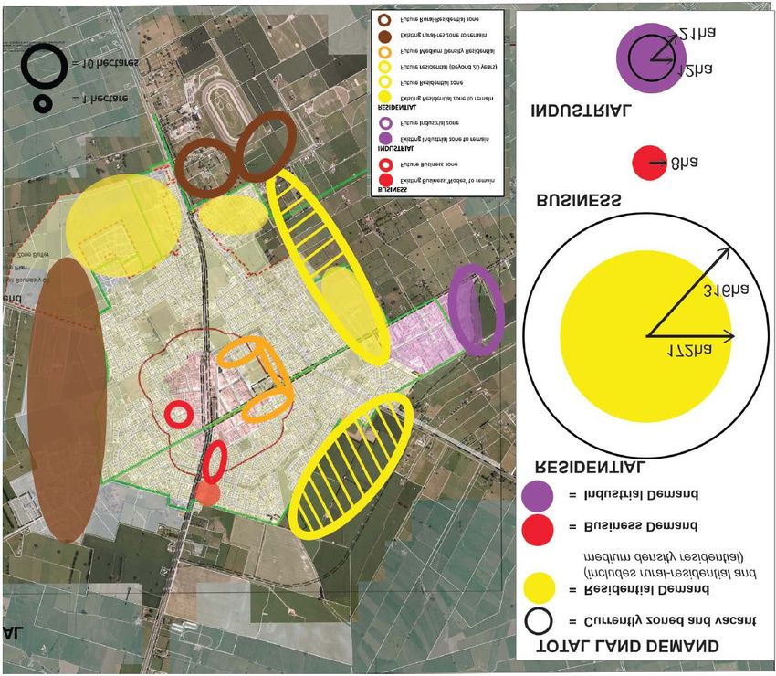
3      Land Budgets
             Residential
                                           Residential
                                           There is a supply of 316 ha of vacant
                                           Residential and Rural-Residential zoned
                                           land in Matamata (shown by the red line in
                                           the adjacent graph). It is estimated that there
Total developed: 368 ha                    will be a demand for 172 ha of residential
Total zoned and vacant: 316 ha             land by 2033 (the blue line in the adjacent
Additional land required by 2033: 172 ha   graph). Therefore, there is a surplus of 144
Surplus of zoned land: 144 ha              ha of land zoned for residential purposes.

              Business
                                           Business
                                           There is no supply of vacant Business zoned
                                           land in Matamata (shown by the red line in
                                           the adjacent graph). It is estimated that there
                                           will be a demand for 8 ha of business land
Total developed: 31 ha                     by 2033 (the blue line in the adjacent graph).
Total zoned and vacant: 0 ha               Therefore, there is a shortfall of 8 ha of land
Additional land required by 2033: 8 ha     zoned for business purposes, with additional
Shortfall in zoned land: 8 ha              land required in the short term.

              Industrial                   Industrial
                                           There is a total supply of 12 ha of vacant
                                           Industrial zoned land in Matamata (red line in
                                           the adjacent graph). It is estimated that there
                                           will be a demand for 21 ha of industrial land
                                           by 2033 (the blue line in the adjacent graph).
Total developed: 24 ha                     Therefore, there is a shortfall of 9 ha of land
Total zoned and vacant: 12 ha              zoned for industrial purposes, with additional
Additional land required by 2033: 21 ha    land required by approximately 2025.
Shortfall in zoned land: 9 ha

    35
4      Transportation

     Road network

     Matamata’s town strategy must recognise the significance of State Highway 27 (SH 27)
     and State Highway 24 (SH 24) as the highest order roads, by avoiding new development
     that uses these main through-corridors for local traffic functions, and by limiting the
     number of vehicle entrances that gains access from these roads.

     Little change in the inter-regional traffic flows through the town is expected.
     Consequently, the construction of a bypass around Matamata will not be warranted
     during the planning horizon. However, alternative road links through the western (SH 27/
     Hinuera Rd through to Peria Rd), eastern (SH 27/Banks Rd through to SH 24), and
     northern (SH 27, via Rawhiti Ave and Tower Rd to connect with SH 24) segments of
     Matamata should be identified.

     The town’s road network carries relatively low traffic volumes and little change is
     predicted. The busiest routes (3,000 – 6,000 vehicles per day) are SH 27/Firth St, SH 24/
     Broadway, sections of Waharoa Rd East, Rawhiti Ave, Peria Rd, and Tower Rd; shown
     pink and orange in the side-bar to the left. Assessment of the road network has not
     indicated a need to specifically exclude parts of the town from consideration for future
     development or intensification.

     Town centre parking

     There are approximately 1,360 public parking spaces in the town centre and immediate
     vicinity. The location of these spaces is shown in the map on the side-bar to the left, with
     the red circles indicating peak occupancy. Parking spaces nearest to the retail “core”
     have a high rate of occupancy. Overall, parking has not reached critical levels as, even
     during peak times, car parking will usually be available within a short walking distance
     from the retail “core”.

     No significant increase in parking demand in the town centre is predicted during the
     planning horizon and the provision of additional public parking is not envisaged. Should
     parking become increasingly constrained, the issue can be addressed through demand
     management such as enforcement of time limits or charging for parking.

36
5      Infrastructure

     Water
     The current average daily water demand, including industrial use, equates
     to approximately 591 litres/head/day, or 4,351 m3/day, with peak usage/day
     at 6,133 m3. The projected growth of Matamata will increase the average
     daily demand to 4,800 m3/day, peaking at 6,767 m3/day.

     The consented water-take limit of 8,400 m3 per day from the Waiteariki
     Stream and the bore sites at Tawari and Matamata South is adequate to
     meet future demand. However, the capacity of the water treatment plants
     and bore sites is currently restricted to 7,400 m3/day. To overcome the
     capacity constraints, additional bore sites and installation of improved
     performance pumps are being considered. Current water storage of 10,500
     m3 will be adequate to meet the future storage requirements.

     Sewer
     The town’s average daily discharge of wastewater is 2,000 m3/day (272
     litres/head/day), with peak flows in the order of 3,600 m3. The projected
     growth will discharge an additional 280 m3 of wastewater per day.

     The treatment plant has a capacity of 3,000 m3 per day. The capacity of the
     existing trunk sewer is limited. Development outside the existing urban limits
     will require significant expenditure on sewer reticulation.

     Stormwater
     The capacity of the town’s reticulated stormwater system is constrained.
     Increases in stormwater as a result of the predicted development will need
     to be detained on-site.

     Development suitability
     As far as provision of reticulated infrastructure is concerned, the areas on
     the north-eastern and south-eastern periphery of Matamata, indicated by
     the green circles on the map in the side-bar, are considered most suitable
     for future development.

37
6      Urban Design

           The table below summarises key urban design principles and objectives and their application in the preparation of
           Matamata’s town strategy:

Matamata    Principle           Urban Design Objective                                     Application in Matamata
            Consolidation and   •   Increase employment and residential capacity,          •   Keep the town compact by providing for new development that is
            dispersal               where appropriate.                                         contiguous with existing urban land-uses.
                                •   Focus walkable nodes and businesses on arterial        •   Consolidate business development around the town centre such as
                                    routes so they benefit from the movement                   along Waharoa Road East (to connect with existing large-format
                                    economy.                                                   retail) and adjoining the existing Business Zone to the west (easy
                                •   Provide compact and efficient public open spaces           access from arterial road without impacting on the inter-regional
                                    near the core, and larger ones towards the                 function of the state highway network).
                                    periphery.                                             •   Concentrate medium-density housing in the centre of the town
                                                                                               where community facilities are within walking distance.
                                                                                           •   Integrate the existing open space network (Founders Park, the
                                                                                               Domain, and the Plantation Reserve near the town centre, and the
                                                                                               sport fields, Pohlen Park, and Swap Park further out from the town
                                                                                               centre), with future development.

            Integration and     •   Develop a logical structure of connected routes.       •   Recognise and enhance Centennial Drive/Tom Grant Drive/Neil
            connectivity        •   Provide cycle and pedestrian routes that offer good        Algar Reserve’s role as open space links, and pedestrian and cycle
                                    continuity.                                                routes.
                                •   Integrate public and private transport networks with   •   Integrate Centennial Drive/Tom Grant Drive with new open space
                                    each other, and with the land uses they serve.             links, to form a continuous cycle and pedestrian route.
                                •   Promote a well-connected local movement system         •   “Channel” pedestrian and cycle movements along defined routes to
                                    which is well integrated with land uses.                   minimise links across the railway line and state highway network.
                                •   Provide street connections to the adjoining            •   Provide for road links to connect and integrate development within
                                    neighbourhoods.                                            the:
                                •   Ensure busier roads and arterials still have lively             o South-western segment of town (Hinuera Road to Peria
                                    frontage conditions; provide service lanes where                      Road);
                                    direct access is unachievable.                                  o South-eastern segment (Banks Road to Mangawhero
                                                                                                          Road); and:
                                                                                                    o Northern segment (Rawhiti Avenue to Tower Road).
                                                                                           •   Enable Rawhiti Avenue to function as a bypass route around the
                                                                                               town centre and recognise the road’s function when considering
                                                                                               adjacent land-uses.
                                                                                           •   Recognise and enhance the role of Tower Road as a pedestrian
                                                                                               link and cycleway connecting town with the Firth Tower Museum.

   38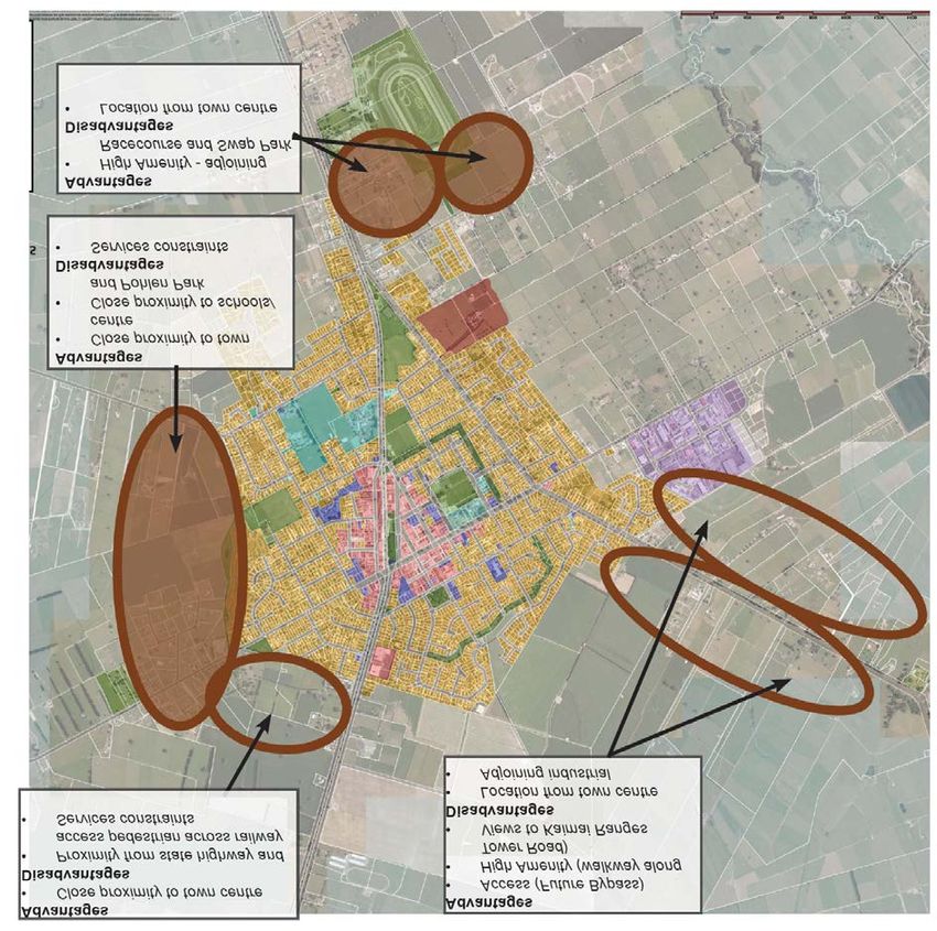
Principle        Urban Design Objective                                    Application in Matamata
     Diversity and    •   Locate new land uses where they will achieve good     •   Locate future industrial uses on the eastern outskirts of town,
     adaptability         synergy with existing uses.                               adjoining (and compatible with) the existing industrial area.
                      •   Ensure adjacent uses are compatible.                  •   Future residential use should adjoin existing development at the
                      •   Provide an appropriate distribution of amenities,         southern, eastern, and north-eastern periphery of town in locations
                          such as shops, schools and parks, where the               where the local street networks can be integrated and where the
                          communities they serve can easily access them.            services reticulation has capacity.
                      •   Plan for a range of employment, residential, and      •   Consider the location of, and accessibility to, schools, open space,
                          community uses, which co-exist in a manner that           shops, and the town centre when determining the preferred
                          strengthens the local condition and adds diversity.       location of new residential areas.
                      •   Consider how the layout will accommodate              •   Locate medium-density residential development near the town
                          changes in use over time.                                 centre, in locations that provide good pedestrian links and access
                      •   Promote mixed-use buildings.                              to open space.
                      •   Develop highly connected street networks that can     •   Integrate the race course with the town, and enhance the equine
                          support a range of activities, which may change           character of Matamata by providing for land in the vicinity of the
                          over time.                                                race course to be used for equine-related activities.
                                                                                •   Promote a vibrant town centre by enabling upper floors of buildings
                                                                                    to be used for residential purposes.

     Legibility and   •   Celebrate regional landmarks and natural features.    •   Recognise the Hobbit-themed Information Centre, Matamata Race
     identity         •   Use rivers and ridgelines to define the edges of          Course, Centennial Drive/Tom Grant Drive/Neil Algar Reserve, and
                          communities.                                              the Firth Tower Museum as important landmarks, and consider
                      •   Promote an urban form and movement network                ways to integrate the landmarks into the town by improving links
                          that is easily understood and negotiated.                 between them.
                      •   Link landmarks and nodes with strongly defined        •   Consider ways in which view planes from town and from new
                          paths.                                                    development areas, towards the Kaimai Ranges, can be preserved
                      •   Use contrast and differentiation in design to make        and maximised.
                          each public space memorable.                          •   Create well-connected local road networks within the three
                                                                                    segments of Matamata created by the route alignment of State
                                                                                    Highway 27 (Firth Street)/the Kinleith Branch Railway Line, and
                                                                                    State Highway 24 (Mangawhero Road).

39
Principle        Urban Design Objective                                     Application in Matamata
     Environmental    •   Provide catchment management plans that define         •   Locate future development where there is capacity in the
     responsiveness       areas for urban concentration, and habitats and            infrastructure and road network, or where capacity can be created
                          natural features for retirement for stormwater             cost-effectively.
                          management.                                            •   Provide for a system of connected open spaces throughout town,
                      •   Consider the distribution of open spaces, and the          with linkages to the Matamata Race Course and Firth Tower
                          relevance of their size and function.                      Museum.
                      •   Protect ecologically sensitive habitats such as        •   Landscape open spaces with indigenous trees and plant species
                          streams and wetlands.                                      that will create a favourable habitat for fauna and flora, to enhance
                      •   Use large park areas, river or stream edges, and           biodiversity.
                          waterfronts as opportunities to integrate ecological   •   Direct development away from soils with the highest productive
                          restoration.                                               capacity.
                      •   Provide for continuity of green networks where the     •   Minimise further encroachment onto productive land by locating
                          specific movements of wildlife, or waterways,              future development, as far as possible, within the existing urban-
                          require this.                                              zoned “footprint”.

40
7      Opportunities and Constraints

                                                        The development opportunities and constraints that informed the
                                                        strategy for the future expansion of Matamata are shown on the
                                                        map in the side-bar and are summarised below:

                                                        Opportunities
                                                        • Services (water, stormwater and wastewater) - there is
                                                          additional capacity for new development on the north-eastern
                                                          and south-eastern periphery, and for intensification of existing
                                                          development in the north-western part of town (green circles).
                            NORTHERN SEGMENT
                                                        • Racecourse - high amenity in the area adjoining the large open
                            (Between SH 27 and SH 24)     space, with views towards the Kaimai Ranges.
     WESTERN SEGMENT
                                                        • Centennial Drive/Tom Grant Drive - high amenity pedestrian
     (West of SH 27)                                      link (green lines).
                                                        • Inter-regional access – State Highway 27 and 24 (red lines).
                       SOUTHERN SEGMENT
                                                        • Views of Kaimai Ranges – High visual amenity (purple
                       (Between SH 27 and SH 24)          arrows).

                                                        Constraints
                                                        • Services (water, stormwater and wastewater) - there are
                                                           limitations on the provision of reticulated services to the west of
                                                           Matamata (red circles). The north-western area is suitable for
                                                           on-site wastewater disposal. Infrastructure limitations in the
                                                           south-western area are currently being investigated.
                                                        • High quality soils – urban development should avoid the areas
                                                           to the north and east of Matamata that comprise the highest
                                                           quality productive soils (red shading).
                                                        • State highways and railway line - development in proximity to
                                                           these transport corridors (red lines and black dashed line) is
                                                           susceptible to noise and vibration effects and can cause
                                                           reverse-sensitivity. The corridors divide the town into three
                                                           “segments” (yellow dotted lines). Traffic, pedestrian and cycle
                                                           movements should be “channelled” along defined routes to
                                                           enable safe links across the corridors.
                                                        • Mangawhero Stream – the stream margins are susceptible to
                                                           flooding (yellow band).

41
8 Development Options
Residential
amenity
Historically, residential development in Matamata has
occurred in a circle, around the town centre. The
current pattern of residential development is
characterised by predominantly low-density single
dwellings. The area surrounding the town centre has a
slightly higher density due to more recent infill
subdivision.
The solid yellow circles on the map in the side bar
show the different options considered for greenfield
residential development. The text boxes on the map
describe the advantages and disadvantages
associated with each option.
The preferred option for residential expansion is to
allow development to progressively take place over
time, in all the locations identified on the map, rather
than in one direction only. This will enable the future
expansion of the town to continue the historical pattern
of concentric development, thereby keeping a
compact, walkable urban form.
Enabling development in all of the identified areas will
also ensure that residents have a range of locations to
choose from depending on their circumstances; for
instance proximity to schools (shown light blue), open
space/sports facilities (green) for young families, or
easy access to the town centre (red) and community
facilities (dark blue) for retired people.
However, residential development will need to be
staged, as outlined in Paragraph 9 “Preferred
Options”, later in this report
42Advantages Medium-density residential
Advantages • Good services
• Close proximity to town centre Vacant “greenfield”
• Vacant greenfield site site It is recommended that the development strategy for
•
access– state highway
Easy access Disadvantages
Disadvantages • Car reliant
Advantages Matamata should identify areas that are suitable for
• Close proximity to town
• Adjoins state highway (high traffic centre medium-density residential development. Whereas the
volume) • services
Good services residential areas of Matamata currently contain
• Services constraints Disadvantages
• Infill constraints
predominantly detached and semi-detached dwellings, the
• Location from schools proposed medium-density areas will be suitable for other
Access to existing roading
network to the south west
housing typologies such as group, cluster, or row-houses,
and retirement cottages; at a slightly higher density
compared to the other residential areas.
Advantages
• Close proximity to town centre
• Adjoins high amenity pedestrian Provision for medium-density residential development is
route (Tom Grant Drive) considered to be an appropriate response to the likely long-
• Easy access to State Highway
24 and 27 term trend towards an ageing population and associated
Disadvantages need for more variety in available housing options. Setting
• Already developed with low
density residential aside specific areas for medium-density residential use
means that additional demand on roads and services due to
intensification can be anticipated and planned for. It also
means that these areas can be developed with their own
unique appeal, without impacting on the established
character of the rest of the residential area.
The map in the side-bar shows the various options
considered for medium-density development (orange
circles). Of the options considered, the “u-shaped” area
adjoining the town centre to the east (solid orange) is
preferred.
This area is preferred because it is located in close
proximity to the town centre, provides easy access to shops
and other amenities, facilitates pedestrian movement via
adjacent Centennial Drive, allows convenient access to
nearby open spaces such as the Domain and the Matamata
Sports Centre, and enables safe and convenient access to
the nearby Matamata Primary School.
43Advantages
• High amenity – Tom Grant Drive and Rural-residential
adjoining rural area
• Close proximity town centre
• Good services Existing rural-residential development in Matamata occurs
Disadvantages predominantly on the north-western periphery of the town,
• Class 1 soils
• Remote from schools off Peria Road. There are also a small number of rural-
Access to the surrounding residential lots off Station Road on the south-western
neighbourhoods to the west and south
periphery. Rural-residential lot sizes generally range from
Existing
Rural-Residential
2,500 m2 to 1 ha. Some of the rural-residential lots are
connected to the town’s water reticulation. All of the rural-
residential lots currently rely on on-site wastewater disposal
as none of the lots are connected to the town’s sewerage
reticulation.
The green circles on the map in the side bar show different
options for greenfield rural-residential development. The
text boxes on the map indicate the advantages and
disadvantages associated with the various options.
Existing
Rural-Residential
The preferred option for future rural-residential development
is the area on the south-western periphery of town (solid
green). The area is well suited to high amenity-rural
residential development that will be compatible with the
character of the adjacent Eldonwood residential estate. The
area has good road connections to the rest of town via
Station Road and Smith Street. Future development in this
location will integrate well with the town’s local road
network.
schools
Long-term, it is envisaged that the rural-residential area will
racecourse. be able to be further intensified through infill subdivision,
depending on demand and the availability of reticulated
services. To this end, building platforms and future road
connectivity will need to be pre-determined so as not to
compromise later subdivision. This will enable the town to
grow beyond the planning horizon, by means of further
intensification rather than to sprawl beyond these limits.
44Lifestyle living
It is recommended that the development strategy for
amenity
Matamata include a “lifestyle living” option. The lifestyle
living area will differ from the rural-residential area in that
further subdivision is not envisaged in this zone. Rather,
large lot sizes will be retained to preserve the rural-
residential character of the area for the long-term.
The introduction of the lifestyle living concept will appeal to
those rural-residential dwellers who seek assurance that
their privacy and amenity will not be eroded over time
through infill subdivision, envisaged in the other rural-
residential area.
To preserve the appeal of the lifestyle living area and to
provide for small-scale farming, minimum lot sizes will be
larger than in other rural-residential areas. The lifestyle
living area will rely on on-site services and will not be
connected to the town’s water or wastewater reticulation.
Road formation standards will also be different, reflecting
the area’s peri-urban character.
Three alternative locations for lifestyle living were
investigated (brown circles on the map in the side-bar),
namely: the western and north-western rural-residential
area, the area to the north-east along Tower Road, and
south of Banks Road near the Matamata Racecourse.
The preferred options are: the western part of Matamata
between Peria Rd and Station Rd where constraints on
reticulated services will in any event limit further subdivision,
and the area between Banks Road and the Matamata
Racecourse where larger “horse lots” are envisaged to
create opportunities for expansion of the equine industry on
land with internal access to the adjacent horse training
facilities.
45Business
Matamata’s Business Zone comprises a square area
centred around the intersection of State Highway 27
(Firth Street) and State Highway 24 (Broadway). The
historic town centre (still the main retail area) is along
Broadway immediately east of State Highway 27, and
along Arawa and Tainui Streets in the vicinity of the
Broadway intersection. A recent large-format retail
development exists to the north of the town centre,
along Waharoa Road East.
With the exception of the fast food outlets at the State
Highway 27/24 round-about, the remaining “strip” of
Business zoned land along State Highway 27,
separated from the town centre by the railway line, is
commercial in character with a mix of uses including
premises serving the motor trade, rural supply, and
service industry.
The red circles on the map in the side-bar indicate the
different options for the expansion of business uses
that were investigated.
The preferred options (shown in solid red) are:
• The “strip” of land along Waharoa Road East,
connecting the town centre to the existing large-
format retail development to the north; and:
• The area adjoining the existing Business Zone to
the west, south of Peria Road.
The extension of the business area along Waharoa
Road East will enable the “large-format” retail area to
be incorporated into the town centre, while the new
western business area will be able to accommodate
new large-format retail, or commercial uses.
46Industrial
Many of the land uses located in the Business
Zone, along State Highway 27 and on the
periphery of the town centre, such as the large
contractor’s yard in Gouk Street, are more
industrial than commercial in nature. Some of
these uses (such as the contractor’s yard) are a
legacy of the historic development of Matamata.
More recently, new service industries have also
established on the town centre periphery, under
the Operative District Plan provisions that permit
light industry in both the Business and Industrial
Zones.
Adjoins The town’s dedicated Industrial Zone is located on
the eastern outskirts, north of State Highway 24.
The area comprises service industry, larger-scale
manufacturing including manufacturing of heavy
machinery, engineering works, and warehousing.
Three options for industrial expansion were
considered, as shown on the map in the side-bar
(purple circles). The options considered are east
of the existing Industrial Zone, south of the
industrial area on the opposite side of State
Highway 24, and an area south-west of town,
opposite the racecourse.
The preferred option (shown solid purple) is the
area adjacent (east) of the existing Industrial
Zone. This area is well separated from residential
areas, and is contiguous with the existing
industrial development thus enabling the local
road network to be integrated and additional traffic
impacts on State Highway 24 to be mitigated.
479 Preferred Options
The map in the side-bar shows the current
urban zones that make up the town of
Matamata (background colours), overlaid
with the preferred development options as
previously described.
The circular scale to the right of the map
shows the amount of land that is currently
Residential zoned and still vacant (black circles)
compared to the projected demand for each
land use (filled circle).
In summary, the preferred options for future
development are:
Residential
• Low-density residential development is
proposed on the south-western, south-
eastern and eastern periphery of town,
on vacant land already zoned Residential
(solid yellow). The areas hatched yellow
Business denote residential development that will
likely only be required beyond the
planning horizon. These hatched areas
are currently zoned Rural.
Industrial • Medium-density residential development
is proposed around the eastern edges of
the town centre, on land currently zoned
Residential, predominantly occupied by
existing dwellings.
48• Rural-residential development is proposed on the south-
eastern periphery of town. The area concerned
comprises the southern part of the solid brown circle
shown on the previous page. It covers vacant land
currently zoned Residential.
• Two lifestyle living areas are proposed. The first area is
on the north-western periphery of town, comprising the
northern part of the solid brown circle shown on the
previous page. It covers vacant land currently zoned
Rural-Residential. The second area is between Banks
Road and the Matamata Racecourse, shown by the
brown circles on the previous page. It comprises Rural
zoned land already in small titles. The area is intended
to accommodate the proposed “horse lots” referred to
previously.
Business
• The red circles on the previous page denote the two
areas proposed to be set aside for business use. Both
areas comprise predominantly Residential zoned land
currently occupied by existing dwellings.
Industrial:
• The purple circle on the previous page denotes the area
proposed to be set aside for industrial use. The western
half of the circle, shown solid purple, is current zoned
Industrial and has been subdivided, but is predominantly
still undeveloped. The eastern half of the circle is
located on existing Rural zoned land.
The area of land shaded grey, to the north-west and south-
west of town, is currently zoned Rural-Residential but is not
Northern Matamata required during the 20-year term of the town strategy.
4910 Town strategy
The town strategy for Matamata, based on the
preferred development options, is shown on
the map in the side-bar.
The map indicates how the existing and
proposed land-uses are to be integrated with
the town’s transport network and
infrastructure.
From an integrated development perspective,
the key elements of the strategy are:
• A compact urban form that preserves as
much land as possible for productive use;
• Continuous pedestrian links and
cycleways that connect the town centre,
schools, and open spaces; create buffers
between adjacent sensitive uses; and
“channel” the movement of people along
predetermined routes to ensure safe and
convenient links across the state highways
and railway line;
• A well-connected local road network that
links all parts of town, minimising travel
distances, enabling local traffic to use
local roads, and supporting walking and
cycling as alternative modes of transport
by ensuring route continuity;
• Integrating land-use with infrastructure by
ensuring that new development takes
place in areas where there is capacity in
the infrastructure networks or where
capacity can be created cost effectively.
50You can also read