Landspouts (non-supercell tornadoes) & the Denver Cyclone
←
→
Page content transcription
If your browser does not render page correctly, please read the page content below
Landspouts (non-supercell tornadoes) &
                  the Denver Cyclone
                                  Ed Szoke
Cooperative Institute for Research in the Atmosphere (CIRA), Fort Collins, CO
                                      &
    NOAA Earth System Research Laboratory (ESRL), Boulder, Colorado

DIA Tower Talk – NCAR   21 August 2014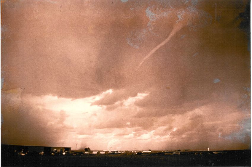
• What the DCVZ is and why it is important
• Cases – mostly non-supercell tornadoes associated with the
  Denver Cyclone (DCVZ) – to demonstrate the variety we see
   • 3 June 1981 – tornadoes WEST of Stapleton
   • 26 July 1985 – Erie tornado – goes across I-25
       • DCVZ boundary displaced more to the west
   • 15 June 1988 – the big one!
       • 4 tornadoes in/near Denver in ~30 min, tower evacuated
         (Stapleton). F2 to even some F3 damage.
   • 6 June 1997 Boulder tornado
   • 4 Oct 2004 – landspoutfest near DIA
       • 11 tornadoes reported in 44 minutes just west of DIA
   • 16 June 2013 – DIA tornado
       • tornado moves to the NW across runway and LLWAS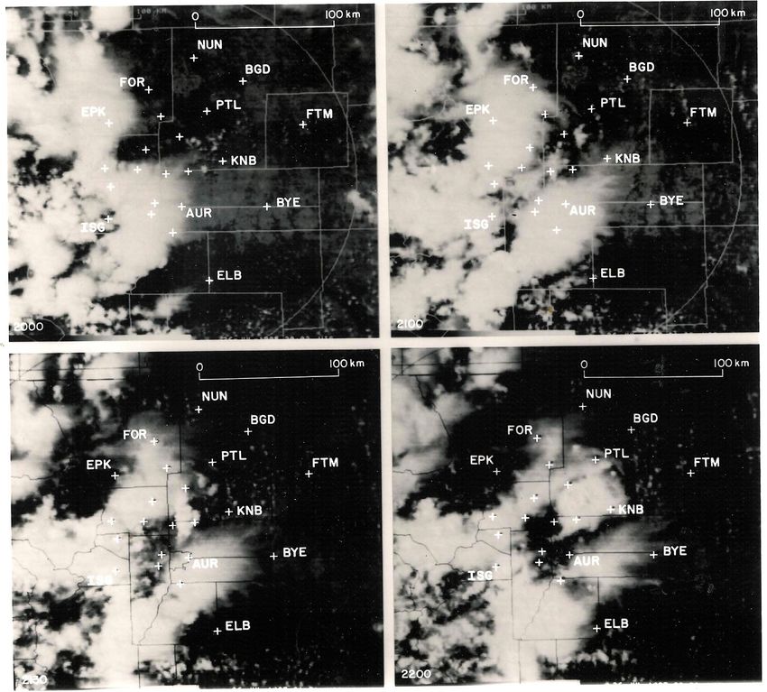
Terrain map   Cheyenne Ridge

              Palmer Ridge

               Raton Mesa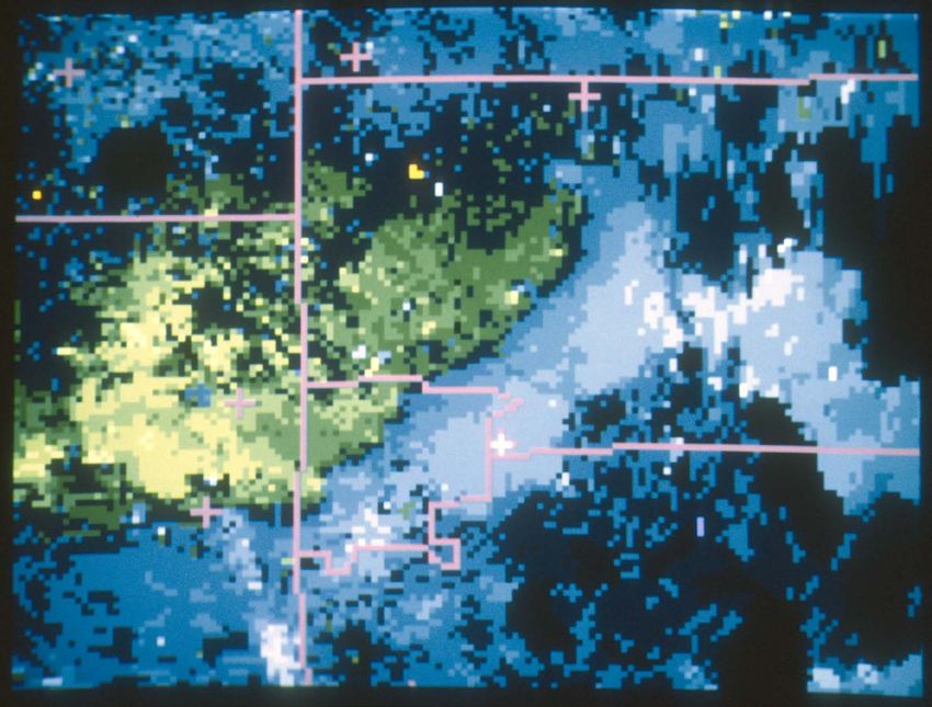
Schematic of the
       Denver Cyclone
South to Southeast flow passing over
the Palmer Ridge under conditions
with some (enough) lower level
stability results in a downstream
turning of the wind.

This forms a zone where the winds
come together...often this zone is over
DIA.

The zone can remain stationary or
move very slowly, and as a result
  1) the local environment is modified
(deepening moisture) to increase the
local chance of a storm
  2) small scale circulations (vorticity)
can form at low levels along the
convergence zone (hence called the
Denver Convergence-Vorticity Zone
or DCVZ)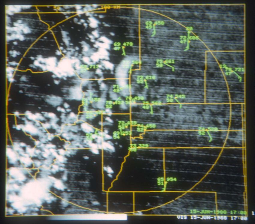
How to make a non-
   supercell tornado
1) Low level vertical circulation
   along the DCVZ (can be present
   without clouds and for hours)
2) Essentially have the source for a
   tornado IF the circulation can
   tighten
3) It CAN tighten if the updraft of a
   growing cloud/cell is positioned
   over the low-level circulation
4) And if this happens you get a
   non-supercell tornado
5) Weaker and shorter lived in
   general than supercell tornadoes
   but we’ve seen up to F3 (EF3)
   and lasting 20 minutes or more
6) But no pre-existing mesocyclone
   so harder to predict
Example 1: Denver tornadoes of 3 June 1981

•   Quick look (pre-dates Doppler radar availability here)
•   More of a supercell
•   But passes over the DCVZ
•   Which in this case was located WEST of the old
    airport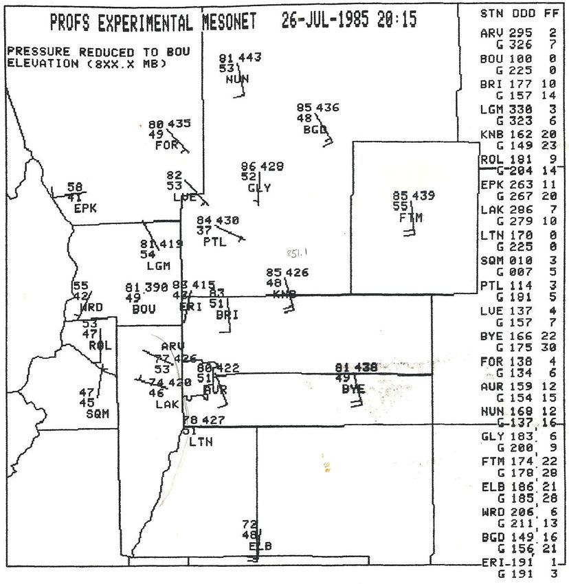
NOAA/PROFS
 mesonet plot
at 1755z (1155
  MDT) on 3
  June 1981
Arrow points to the
old Stapleton Airport
location.
Weak DCVZ is
located just west of
the airport at this
time. Temperatures
and dew points are in
oC.
NOAA/PROFS
  mesonet plot at
1950z (1350 MDT) on
    3 June 1981

Radar echoes are from the
Limon WSR-57 (a test
Doppler radar was
supposed to start from
near the airport on 1 June
but was delayed until 5
June!). We can see
outflow near and west of I-
25 moving east from the
foothills storms. The
DCVZ still lies west of the
airport, essentially right
over the city of Denver.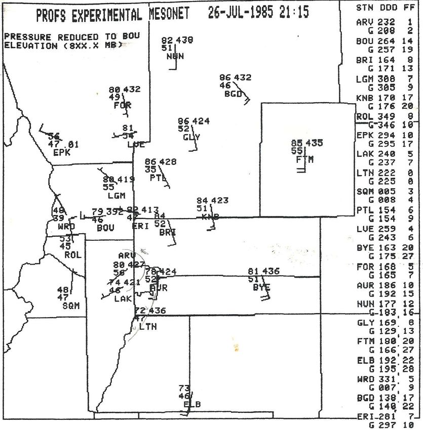
NOAA/PROFS
 mesonet plot
at 2030z (1430
MDT) on 3 June
     1981

The tornadic storm (in
this case likely a
supercell) moves off the
foothills to the northeast
and passes right over
the DCVZ. Did the
convergence zone play
a role in the subsequent
tornadoes? (Or...stated
another way, would this
storm have produced
tornadoes without the
DCVZ which it
happened to move
over?).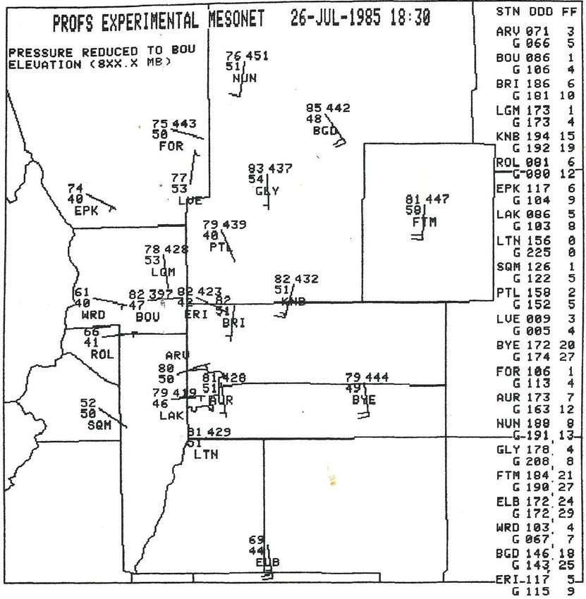
3 June 1981
3 June 1981
Rocky Mountain News 4 Jun 1981
Example 2: The Erie, Colorado I-25 non-supercell tornado
of 26 July 1985
• One of the earliest Doppler radar studies of the life
cycle of a non-supercell tornado
• Typical environment – no other severe weather
occurred
• Nice example of how it often takes an interaction to
produce the spin-up
– In this case an outflow boundary from weak
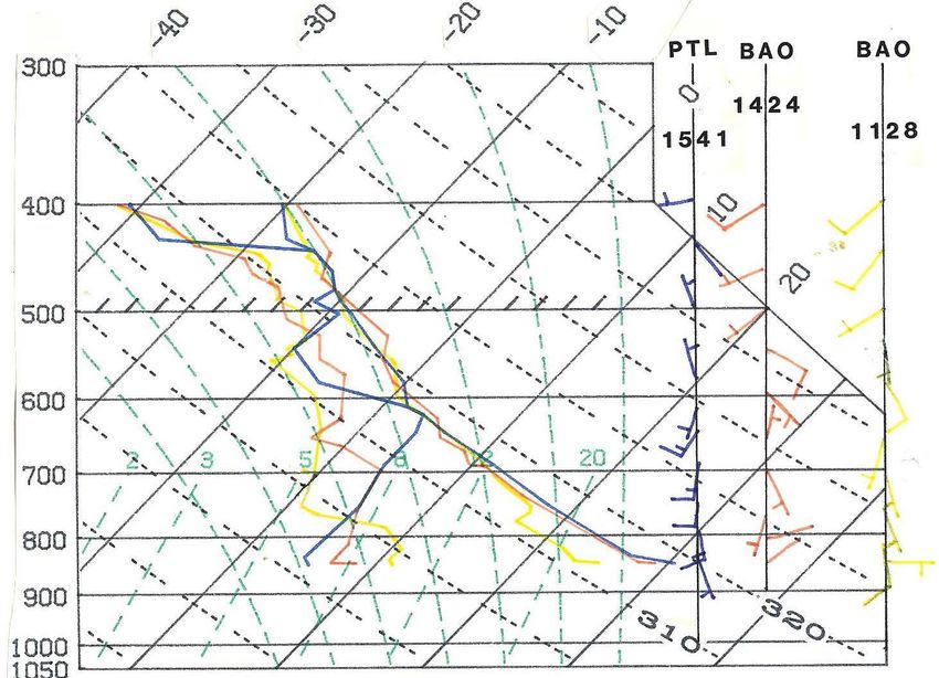
foothills/mountain convection intersecting the DCVZVertical wind shear on 26
July 1985
The very weak vertical wind
shear is a lot like that found in
the tropics (GATE sounding).The then- experimental “PROFS Mesonet” 1830z (1230 MDT) on 26 July 1985 Robust southerly flow on the plains, a somewhat disorganized DCVZ near and east of I-25. No DIA back then!
Noon

           Convergence (x10-5s-1)   Vorticity (x10-5s-1)
1400 MDT
The then- experimental “PROFS Mesonet” 2015z (1415 MDT) on 26 July 1985 Some of the boundaries are pretty subtle and only trackable using the Doppler radar data.
1500 MDT

           Convergence (x10-5s-1)   Vorticity (x10-5s-1)
1530 MDT
The then- experimental “PROFS Mesonet” 2115z (1515 MDT) on 26 July 1985 Tornado occurs at the arrow from 1535 to 1553 MDT and crossed I-25.
Series of experimental soundings near the DCVZ boundaries on 26 July 1985

Not only did the boundaries provide the low-level circulation, they also modified the
local environment. There was no other severe weather reported on this day.
The grid is
slightly off, but
this series of
visible images
shows how the
tornadic storm
(yellow arrow)
ended up
forming along       2000z/1400 MDT   2100z/1500 MDT
the DCVZ in an
area that
remained in
sunshine and
where the
outflows hit it.

                                      2200z/1600 MDT
                    2130z/1530 MDT
1945z (1345 MDT)
2045z (1445 MDT) 2129z (1529 MDT)
Pictures looking east from Boulder of the initial clouds along the DCVZ and then the
explosive development following collision with the weak outflow boundaries.The then- experimental “PROFS Mesonet” 1830z (1230 MDT) on 26 July 1985 No DIA back then!
The then-
experimental
“PROFS Mesonet”
1830z (1230 MDT)
on 26 July 1985
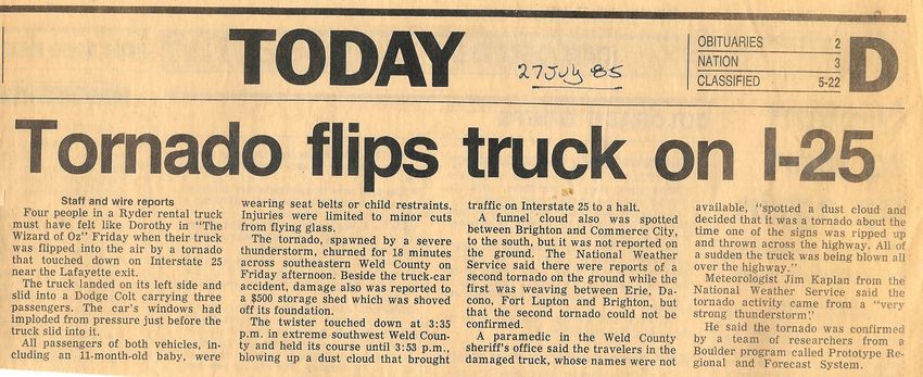
From the Boulder Daily Camera on 27 July 1985Example 3: The Big One – 4 Denver area significant non-
supercell tornadoes within half an hour on 15 June 1988
• Another Denver tornado outbreak, but shifted to the
east of the 3 June 1981 tornadoes
• Some vertical wind shear, unstable environment
• Another nice example of how it often takes an
interaction(s) to produce the spin-ups
– In this case two outflows that intersect the DCVZ in just the
right way
• One tornado went over the old Stapleton Airport4th tornado is near Brighton
Roberts and Wilson 1995
~2208z (1608 MDT) F1
~2225z (1625
MDT) F1
~2225z (1625 MDT) up to F3
Note the different appearances of the tornadoes – we found
this was related to moisture differences rather than strength.From Roberts and Wilson MWR 1995
I believe the tower was evacuated for this
tornado.
x approximate location of where picture was taken
I took this picture ~2223z (1623 MDT) looking
WSW across the old NWS site (radome building is
visible). Largest condensation funnel I had seen.
Could also see trees/branches being ripped from
the ground. Max damage was F2.
This from Rita’s
paper: what did
the planes do?Denver Soundings
from Roberts and
Wilson MWR
paper.
There is some decent
vertical wind shear on
this day and some
storms to the east of
Denver produced
severe sized hail.Summary of the 2
outflow
boundaries hitting
the DCVZ and
producing the
tornadoes1700z (1100 MDT) on 15 June 1988 Fairly typical with dew points near 50 to the lower 50s. S to SE flow on the plains but fairly disorganized flow near and west of the airport.
1830z
 (1230
MDT) on
15 June
  1988

The DCVZ is
not particularly
strong but is
about over the
airport.

Early storms
have developed
to the south
over the Palmer
Divide and in
the foothills and
mountains nw
of Boulder.
2000z
  (1400
 MDT) on
 15 June
   1988

The wind at
Stapleton
Airport is calm
with temp=77
and dew point
51.

Storms
continue to
move off the
foothills with
some outflow
from the NW.
Pretty big storm
to the south.
2030z
 (1430
MDT) on
15 June
  1988

The DCVZ is
still not that
strong but is
right over the
airport.
2100z
 (1500
MDT) on
15 June
  1988

The storm well
to the se of the
airport
produces an
outflow that
moves to the
nw and appears
to produce a
storm on the
DCVZ south of
the airport. But
this storm
moves away,
develops mid
level rotation
and severe hail
but no
tornadoes (and
sucks chasers
to the east!).
2130z
 (1530
MDT) on
15 June
  1988

But that new
storm sends
another outflow
to the NW
towards the
DCVZ.
Meanwhile the
weak
convection over
Boulder County
sends an
outflow to the
SE towards the
airport.
2200z
 (1600
MDT) on
15 June
  1988

And then they
intersect.
Detailed look at the
flow near the DCVZ
     after it was
intersected by the 2
outflow boundaries
 at 1600 MDT (dual-
  Doppler analysis
   from Roberts &
    Wilson, MWR)

It is believed that the way
     the two gust fronts
  intersected the DCVZ at
an angle, instead of head
on, produced an unusually
   large number of small-
scale circulations, some of
    which grew into the 4
          tornadoes.
Doppler velocity (blue toward) at 2201z/1601 MDT
Terrain map

here have a color terrain map, perhaps with a schematic of the DCVZ
Example 4: Speaking of changing appearances – the
         Boulder tornado of 6 June 1997

• Very moist environment – in fact forecasters worried
  about flooding rains
• Deeper SE flow – caused the DCVZ to shift from the
  airport to the WNW with time
• Eventually wound up in eastern Boulder County
  where it produced a very visible tornado
The Denver sounding on this day (1200z/0600 MDT) has deep ESE flow and this moves the DCVZ westward during the day.
Evolution of the
  DCVZ on the

                                                                       1800z/1200 MDT
Boulder tornado

                                  1700z/1100 MDT
                                                   x                                    x

day of 6 June 97
A similar feature to the
DCVZ occurs north of the
Raton Mesa near Pueblo,
and is seen on this day as a
cyclonic circulation in the low
cloud field.                                               Pueblo
                                                           cyclone
Other two arrows mark the
DCVZ, which slowly moves
westward with time as
storms develop on it, but no
tornado forms until it gets to
                                  1900z/1300 MDT

                                                                     2000z/1400 MDT
Boulder County. The                                    x
                                                                                        x
tornado develops ~1410
MDT and moves WSW,
passing just north of my
house then to the west.
Why no tornado(es) earlier?
Perhaps because the DCVZ
was not stationary in this
case. Weak outflow from
the west may have
intersected it in Boulder
County.
At first this was a typical non-supercell Colorado tornado with a tiny funnel from cloud base and a swirl of dust on the ground. Then it passed over Baseline Reservoir and became a full-fledged Colorado waterspout (this photo ~1415 MDT). The NWS (then in Denver) actually got the first report of this storm from an observer way to the east in Lockbuie, who estimated it was over Louisville. I called in to NWS to tell them exactly where it was, near my house! After exiting the lake on the SW side the tornado lifted about 1420 MDT. I did a bicycle survey and found a 2x4 in the side of a barn just across from where it entered the lake. The owner said the plank had been in the barn before the tornado. The tornado reportedly turned a car sideways on Baseline Road. Just before it entered the lake it crossed a small field of foot tall grass, and one could clearly see flattened grass but no more than about 20 feet across. Rated as an F1.
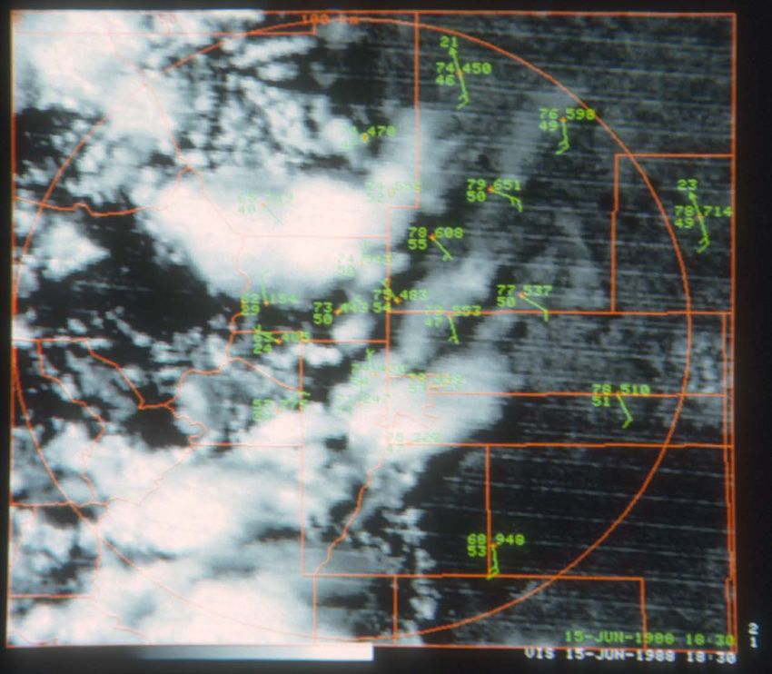
Example 5: October tornadofest near DIA. 11 tornadoes
             reported on 4 October 2004
 • 11 non-supercell tornadoes developed NW of DIA
 • F0 except 4 rated F1
 • Occurred within a 44 minute period from 2204-2248z (1604-
   1648 MDT)
 • Tornadoes developed after the DCVZ was intersected by a
   thunderstorm outflow boundary from the east
12z/4 Oct 2004 Denver Sounding Weak vertical wind shear but a fairly unstable and moist airmass.
METAR plot with radar reflectivity at 2000z/1400 MDT on 4 Oct 2004

Yellow arrow points to DIA. DCVZ (white arrows) is found just west of the airport at this time.
METAR plot with radar reflectivity at 2100z/1500 MDT on 4 Oct 2004

Note the wind increase from the SE at DIA – this is outflow from storms to the south
A close look at
  the velocity
(from the KFTG
radar) at 2115z
showed 4 small
      scale
  circulations
 present along
   the DCVZ.

Green is toward, red
away.
Visible image with observations at 2200z/1600 MDT on 4 Oct 2004 Just before the tornadoes start. The weak storms to the east sent a surge westward, foothills cells a weak surge to the
METAR plot with radar reflectivity at 2200z/1600 MDT on 4 Oct 2004

Echoes are just being seen near ground level as the tornadoes are about to begin since the cells are growing still.
A close look at
  the velocity
(from the KFTG
radar) at 2200z
– still have the
  4 small scale
  circulations
    along the
      DCVZ.

 Close call for
     DIA!

Green is toward, red
away.
The tornadoes were the only severe weather near Denver that day. nice video at https://www.youtube.com/watch?v=3FuuP7uJVEk
Example 6: 18 June 2013 tornado on the DIA runways

• Tornado develops at se edge of DIA and moves to the
  NW
• Airport terminals evacuated
• Passed right over a couple of LLWS sensors
• First use of total lightning (in-cloud and cloud-to-
  ground) to help issue a warning with some lead time
Tornado tracked across the N-S runway area heading towards the terminal

                                                             2:22 MDT
Some views of the tornado
Some views of the tornado
Empty DIA concourse after evacuation to tornado shelters
Denver Sounding at 1200z/0600 MDT on 18 June 2013

Not much vertical wind shear (but some). Steep lapse rate above the stable layer. Good low-level moisture.
Visible satellite image at 1815z/1215 MDT on 18 June 2013

Arrow points to DIA. Initial cells form over the higher terrain.
Visible satellite image at 1915z/1315 MDT on 18 June 2013

Arrow points to DIA. An hour later some cells moving onto the plains, but not all survive.
Visible satellite image at 2002z/1402 MDT on 18 June 2013

Arrow points to DIA. Strongest storm develops over the DCVZ, which was basically lying south to north over DIA.
Total Lightning data and the DIA tornado on 18 June
    •   Radar was very close to the tornado
          – 88D ~7 miles away
          – Terminal Doppler radar (TDWR) ~11 miles away
                                                 Composite Reflectivity from 88D at 1936
                                                 UTC

    CO LMA display 1930-40 UTC
Composite Reflectivity shows echo aloft south of DIA, and in-cloud lightning first seen but already
increasing (arrow). No real circulation yet near the surface. Note second weaker cell to the north.
Total Lightning data and the DIA tornado on 18 June CO LMA display 1940-50 UTC Velocity at 0.3o from TDWR at 1952 UTC We start to see a circulation near the surface, meanwhile in-cloud lightning increasing rapidly (indicative of increasing updraft – a key to non-supercell tornadogenesis) in the southernmost cell. Now see lightning aloft in the northern cell (over DIA) (light green arrow)
0.3o TDWR reflectivity at 1958 UTC                 A few minutes later...

                                        Velocity at 0.3o from TDWR at 1958 UTC

                                     Southern circulation tightens but no tornado
                                     forms with this cell. Start to see a circulation
                                     with the northern cell.
                                       Composite reflectivity at 1954 shows
                                       more rapidly growing northern cell
Total Lightning data and the DIA tornado on 18 June CO LMA display 2000-2010 UTC Velocity at 0.3o from TDWR at 2005 UTC The northern circulation and cell take over, also shown in the total lightning trend, but still no confirmed tornado on the ground (warning is issued shortly after this time). Touchdown not confirmed until 2022 UTC via call to the DIA tower!
Total Lightning data and the DIA tornado on 18 June

                                               Velocity at 0.3o from TDWR at 2022 UTC
Reflectivity at 0.3o from TDWR at 2022 UTC

TDWR reflectivity and velocity image at 2022 UTC when tornado was confirmed by DIA
tower. Hook echo is seen in the reflectivity with shear in the velocity image >100 knots.
Max velocity from the radar was 90 knots (flow away (red) from the radar).
How predictable are these tornadoes? Enough confidence for this case (June) to put in the HWO
Closing thoughts...

12 June 1988 Rocky Mountain News (3 days before the tornado hits Stapleton!)
• AT THE TOWER, ONE CAN SEE LINE OF CLOUDS
GROWING ALONG THE DCVZ: IF SO, BE ON THE
LOOKOUT FOR TORNADO FORMATION
• MONITOR KFTG RADAR FOR VORTEX
SIGNATURE
• IF PRECIPITATION IS DUMPING OUT, THEN
THAT LOCATION IS UNLIKELY FOR NEW
TORNADO FORMATION; TORNADO MOST LIKELY
PRIOR TO FORMATION OF PRECIPITATION
•MOVEMENT OF TORNADO: DOES STORM
REMAIN ANCHORED TO DCVZ OR DOES IT
ACQUIRE A LIFE OF ITS OWN AND MOVE AWAY?
• LOOK FOR DCVZ LOCATION FOR POSSIBLE
GROWING CUMULUS CONGESTUS CLOUDS: USE
VISUAL OBS, RADAR, AND SFC OBS
• IF LOCATION OF GROWING CLOUDS IS NEAR DIA,
BE EXTRA VIGILANT
• IF TORNADO FORMS, BE AWARE OF ITS MOTION
(OBVIOUS!)
• ONCE PRECIPITATION HAS DUMPED OUT, FORGET
ABOUT THAT LOCATION AND LOOK ELSEWHERE
FOR POSSIBLE TORNADO FORMATION
• THERE MAY NOT BE A CONDENSATION FUNNEL:
LOOK FOR DUST WHIRLS AT THE SFC BEING LOFTED;
CONDENSATION FUNNEL OFTEN FORMS AFTER
TORNADO HAS BEGUN AT THE GROUND
• SEE Severe Convective Storms and
Tornadoes,2013, by H. Bluestein, Springer, pp.
340 – 341, for mobile Doppler radar imagery
and photos of
a landspout during VORTEX2 (Fig. 6.27)
End
Wall cloud as the storm passes near DIA – not sure of the time of this photo.
26 May 2010 –
  strong storms
 develop on the
 DCVZ near DIA
 (pre VORTEX-2
      part)
                     1949z        2025z
  Approximate                2110z
  locations of
  the tornado
                   1930z     1945z
    reports

5 tornadoes?
Or none?
Officially one
(then another in
Weld County that
is not shown
here)
Some storm photos – scud or wall cloud? Or funnel? Or tornado??
2 more photos from near DIA
2 photos of lowering over DIA
Photo from Hudson
Photo from Wiggins
2 photos from Lochbuie
Photo from Watkins
2 photos from KeenesburgHail was a big issue with the storm (and subsequent storms) Areal view of the hail swath near DIA
Case 2: Landspouts on 16 Aug 2010

                                 Tornadoes north of Gary
                                      2154Z and 2217Z

3 SW Agate tornado – 2016Z

                             Deer Trail tornado – 1957Z
1800Z KFTG reflectivity and velocity
overview
DCVZ
1800Z
stationary
boundary
DCVZ T
tornado here at
~20Z
outflow
boundary 1900Z
weak cell
1900Z2000Z KFTG reflectivity and velocity
overview
separate boundary new outflow
collision here with boundary
the DCVZ
T tornado here at
T tornado with this ~20Z
cell at 2016Z
DCVZ outflow/boundary collision 2000Z
Leads to stationary
developing boundary/DCVZ
cells
2100Z
2100Z2200Z KFTG reflectivity and velocity
overview
tornadoes with this
cell ~22Z tornadoes here at
~22Z
2200Z
2200ZWind analysis comparison at 2000z– LAPS/1km (which uses Doppler winds) has the
strongest NW winds in the circled area closer to what the Doppler velocity indicated. Others tend to be
too light, though of these HRRR comes appears to come closest. Very few obs in area circled.
LAPS/5 km LAPS/1 km STMAS
RTMA 15 kt NW
winds
HRRR
KFTG velocityDid LAPS at 1 km resolve the
(pre-)tornadic vortices along the
DCVZ?
Looks like it did, but, annoying line of
concentrated vorticity east of where
the action is.
but why
locations of
is this
tornadoes along nice… here?
the DCVZ
LAPS 1km vorticityYou can also read