HYNET NORTH WEST CARBON DIOXIDE (CO2) PIPELINE CONSULTATION FEBRUARY - MARCH 2022 - CARBON DIOXIDE PIPELINE CONSULTATION HUB
←
→
Page content transcription
If your browser does not render page correctly, please read the page content below
HyNet
North West
CARBON DIOXIDE (CO2)
PIPELINE CONSULTATION
FEBRUARY – MARCH 2022
About HyNet
North West
HyNet North West is a ground-
breaking energy project that
will unlock a low carbon
economy for North West
England and North Wales to
                                     We are in a climate emergency and we need to act quickly to
put the region at the forefront
                                     reduce our emissions. HyNet gives the North West of England
of the UK’s drive to net zero.
                                     and North Wales a solution which can be rolled out to reduce
HyNet will produce low carbon        the region’s CO2 emissions this decade. The project comprises
hydrogen to replace the fossil       of several different elements, including upgrades to existing
fuels we use to fuel our industry,   facilities as well as the construction of new infrastructure.
transport and to heat our homes.
                                     HyNet is the UK’s leading industrial decarbonisation
HyNet will also capture and
                                     project, with the North West and North Wales being
lock away carbon dioxide (CO2)
                                     selected by Government as one of only two regions to begin
emissions produced by the energy
                                     decarbonising from the mid 2020s, bringing economic and
intensive industries which make
                                     environmental benefits to the area and across the UK.
the products we rely on every day.
This consultation
This consultation relates to an
underground pipeline that will safely
transport CO2 from existing local
industry and the new HyNet hydrogen
production plant at Stanlow, to
be permanently stored offshore in          We first consulted on these proposals          to have their say on our plans as your
depleted gas reservoirs under Liverpool    in Summer 2021 when we presented               feedback and insight will help to shape the
Bay. Other elements of HyNet will          two possible routes for the newly built        route of the CO2 pipeline. Before finalising
be consulted upon separately.              CO2 pipeline, along with alternative           the detailed route, we will listen to, and
                                           options for some elements. We have             consider, your feedback on the preferred
We understand how important it is to       now selected a preferred route which           route and potential mitigation measures
listen to views from those that live and   we believe is the best option and on           for the route and proposals. Following this
work near the proposed development.        which we would like your comments.             consultation, we will be preparing to submit
We therefore would like to hear your       Along parts of the preferred route, we         an application for development consent to
views on our proposals to install a        are also asking for your views on several      the Secretary of State for Business, Energy
new CO2 pipeline between Stanlow           ‘sub-options’ which you can find more          and Industrial Strategy (BEIS) later in 2022.
(Cheshire), and Flint; and to repurpose    information about within this brochure.
an existing an existing natural gas                                                       This brochure provides information on the
pipeline to transport CO2 between Flint    We developed the preferred route               work and studies which have shaped our
and the existing Point of Ayr Terminal     by reviewing local survey data and             proposals so far. You can also find more
in North Wales. The CO2 pipeline will      taking into account feedback from the          information and provide your comments
include a number of Above Ground           initial consultation. We also collected        online at www.hynethub.co.uk. If you would
Installations (AGIs) and Block Valve       data from organisations such as                prefer a hard copy of the consultation
Stations (BVS) along the route.            local councils, local environmental            materials, or if you require these in different
                                           groups and utility companies, as well          formats such as braille or large print, please
                                           as undertaking our own studies.                contact us (details on how to do this are
                                                                                          on the back cover of this brochure).
                                           We believe it is important that local people
                                           and communities take this opportunity
HyNet North West

The HyNet North
West Consortium
HyNet comprises a core consortium
of eight partners who are developing
the project’s main infrastructure. This
includes Eni, who are leading the
development of the CO2 pipeline.
HyNet also works closely with a wide
range of global companies and brands
across many sectors – from chemicals,
glass and oil refining to food, paper
and automotive. These organisations
are supportive of HyNet and are
ready to actively explore the switch to
low carbon hydrogen as soon as it is
available from HyNet. This will enable
us, as consumers, to buy products from
brands which are contributing towards
the fight against climate change.

The story so far
To successfully tackle climate change, all parts of the
economy must decarbonise and become greener,
including heavy industry. That’s why the Government has
prioritised HyNet North West as one of the first two clusters
to decarbonise some of our biggest industrial areas.
North West England and North Wales have always been areas
of industrial innovation, providing much of the food, fuel,
products and services that allow this country to thrive.

The region has a proud industrial heritage and remains home
to many world-class industries including chemicals, glass,
ceramics, oil refining, food, paper and automotive. However,
these energy intensive sectors currently emit significant
amounts of CO2 during their manufacturing, and need to
decarbonise to enable long-term, sustainable operation.

The region’s legacy has resulted in an abundance of highly skilled
workers and infrastructure. This means that instead of building
‘from scratch’, HyNet can re-purpose existing infrastructure and
benefit from a first-class workforce, allowing us to find more
efficient ways to help the region to decarbonise for the future.

HyNet will not only be providing low carbon energy for industry.
Hydrogen can also power transport and blend into the gas
network to heat our homes, helping to reduce emissions
in our day-to-day lives. Once operational, the project will
support a low carbon future across Liverpool City Region,
Greater Manchester, Cheshire, North Wales and Lancashire.

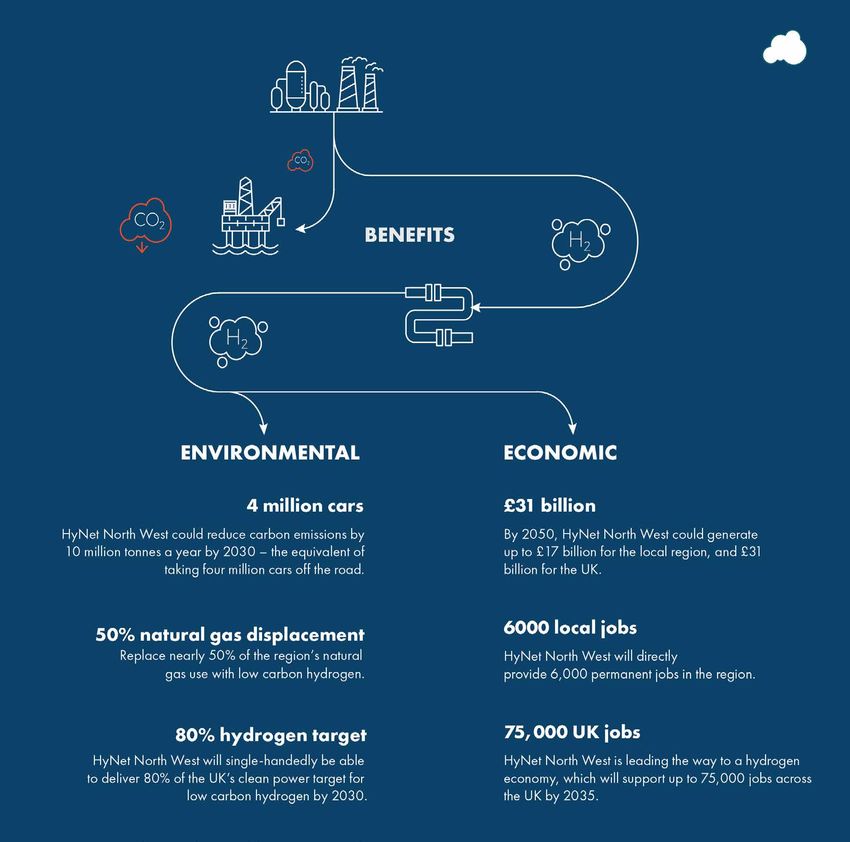
Benefitting local
people and the
environment
Creating opportunities for hydrogen
production and carbon capture will
bring benefits for local people, the
region, and the UK as a whole.

HyNet is a national infrastructure
project with a regional focus. Not
only will it make a big difference
towards reducing the amount of
CO2 we emit, it will also have longer-
term benefits. Through developing
HyNet this, we will help foster a new
age of industrial innovation in North
West England and North Wales.
Local                            Regional                             National

HyNet will create thousands      HyNet will make North                HyNet has the potential to
of new jobs in the North West    Wales and the North West             reduce carbon emissions by 10
and North Wales, creating        region a leader in clean             million tonnes of carbon per year
opportunities for local people   industrial innovation, tapping       by 2030, the equivalent to taking
to develop new skillsets and     into the area’s blend of             four million cars off the road.
train to work in exciting,       industrial experience and
                                                                      This ambitious project will
world-leading sectors.           scientific expertise.
                                                                      provide world-leading solutions
                                 We want the region to be             for a cleaner, greener world
                                 recognised as a centre for           for generations to come.
                                 innovation and clean growth,
                                 creating opportunities, attracting
                                 inward investment and boosting
                                 the region’s reputation as a
                                 highly attractive location for
                                 sustainable organisations. With
                                 more opportunity comes more
                                 investment, boosting growth
                                 and attracting new talent to
                                 spread regional prosperity.
Carbon Capture and
Storage technology
Carbon Capture and Storage (CCS) is a safe and proven technology that securely
stores CO2 and prevents it from being released into the atmosphere. It is the
first step in our vision for Net Zero. The UK Government and the Climate Change
Commission see it as an essential technology for the UK to achieve its net zero
emissions reduction target. The CO2 is captured at source from industry. It is
then transported by pipeline to permanent underground storage sites.

HyNet’s CCS infrastructure will:

 Capture CO2 from industrial         Transport CO2 via            Permanently store
      sources, including         underground pipelines to      captured carbon dioxide
   industry and hydrogen           a secure storage site.     deep beneath the seabed.
    production processes.

You can find out more about how the CO2 pipeline and the technology
works by watching the short animation on www.hynethub.co.uk.
Putting safety
first
HyNet could provide
enough hydrogen to
The HyNet consortium partners displace nearly 50%
will never compromise on safety. of natural gas use
For instance, Eni UK has extensive across the region.
experience in designing, building
and operating safe and effective
high-pressure gas pipelines.
We will utilise this expertise to
develop the CO2 pipeline. We will
By 2050, direct spend on
incorporate principles of safe design
HyNet North West and
based on our own design standards, related inward investment
relevant industry codes of practice, will equate to £17 billion for
the local region, and £31
and the requirements of the
billion for the UK.
Pipelines Safety Regulations 1996.
HyNet will support
up to 75,000 jobs
across the country
by 2035.How will the CO2
be transported?
POINT OF AYR
GAS TERMINAL
The CO2 will be safely transported to depleted
reservoirs in Liverpool Bay by a pipeline network
comprising new and existing pipelines. This HOLYWELL
application covers the following four elements:
• A new 20” pipeline to convey CO2 from Ince
to Stanlow SAUGHALL
FLINT INCE
• A new 36” pipeline running from Stanlow CONNECTION
and connecting to the existing Point of Ayr
to Connah’s Quay Natural Gas pipeline at a FLINT AGI RIVER DEE
STANLOW
location close to Flint
• A new 24” pipeline connecting the
CONNAH’S QUAY
proposed Flint AGI to Flint Connection
• The existing 24” Point of Ayr to Connah’s
Quay natural gas pipeline which will be
Existing Flint Connection - PoA Pipeline (24”) (part
repurposed to transport CO2 to Point of Ayr
of the Existing Connah’s Quay - PoA Pipeline)
From here, the CO2 pipeline runs through
The part of the Existing Connah’s Quay - PoA
the Point of Ayr Terminal and then through
Pipeline which is to be decommissioned
another ‘foreshore’ pipeline which extends
underwater to the depleted gas reservoirs Proposed Flint AGI - Flint Connection Pipeline (24”)
in Liverpool Bay, where the CO2 is injected
and safely stored. These elements are not Proposed Stanlow - Flint AGI Pipeline (36”)
included in this application and planning
consent will be applied for separately. Proposed Ince - Stanlow Pipeline (up to 20”)What happens offshore? The CO2 will be transported in a pipeline under the sea from the foreshore at Talacre to multiple existing offshore platforms, located in Liverpool Bay. From here, the CO2 will be injected into the depleted gas reservoirs. These depleted reservoirs are a safe, secure and natural way to store the captured CO2. We’re reusing these natural features which have stored fossil fuels for millions of years. The offshore CO2 pipeline does not form part of this consultation. We will consult with the relevant stakeholders on the offshore works, including the Oil and Gas Authority, the Marine Management Organisation and other environmental bodies to ensure their views are taken into account and incorporated into the offshore design.
Planning consents
                                                                      OUR DCO APPLICATION WILL PASS THROUGH SIX STAGES:

                                                                  1   PRE-APPLICATION STAGE
and DCO stages                                                        Statutory consultation and an EIA to be carried
                                                                      out before submitting an application (planned for
                                                                      Summer 2022). This is the stage we are in now.
As the new-build CO2 pipeline exceeds 16km in length, it
                                                                  2   ACCEPTANCE (SUMMER/AUTUMN 2022)
is classed as a Nationally Significant Infrastructure Project
(NSIP). This means that we need to apply for a special kind of        The DCO application is submitted and the Planning
planning consent known as ‘development consent’ which is              Inspectorate has 28 days to decide whether it meets the
granted in the form of a Development Consent Order (‘DCO’).           standards required to be accepted for pre-examination.
The planning application for the DCO will seek consent for:
                                                                  3   PRE-EXAMINATION (AUTUMN/WINTER 2022)
 • Construction and operation of:                                     During this phase, any member of the public can register to
         – The new sections of pipeline from Ince to Stanlow          become an interested party to give their views on the DCO
           Refinery and from Stanlow Refinery to Flint.               application before and during the examination. An Examining
         – The Above Ground Installations serving the pipeline.       Authority will be appointed. The Examining Authority will hold
                                                                      a preliminary meeting and set the timetable for examination.
         – The Block Valve Stations located on the existing
           repurposed pipeline.                                   4   EXAMINATION (EXPECTED WINTER – SUMMER 2023)

 • Compulsory acquisition powers for land relating to the             The Examining Authority will conduct their six-month
   new and existing pipelines.                                        examination on behalf of the Secretary of State.
                                                                      Interested parties can provide further views at this stage
 • New powers to use the existing pipeline for transport of
                                                                      in writing, and request to speak at a public hearing.
   CO2.
                                                                  5   RECOMMENDATION (EXPECTED AUTUMN 2023)
The DCO application will be examined by an Inspector or
a panel of Inspectors, known as the Examining Authority.              The Examining Authority provides a report and
They will make a recommendation as to whether or not                  recommendation to the Secretary of State.
development consent should be granted. It is then the role        6   DECISION (EXPECTED WINTER 2023)
of the Secretary of State for Business, Energy and Industrial
                                                                      The Secretary of State makes a decision on the DCO application.
Strategy to make the final decision on whether to grant
or refuse development consent for the CO2 pipeline.
We intend to submit a DCO application in Summer 2022.
As well as the DCO application, we will also be seeking planning permission from Flintshire County Council for potential works to modify the existing pipeline and the facilities at the Point of Ayr (PoA) Terminal. These elements of the project do not form part of this consultation, which is focused on the DCO application, but they will be subject to a separate consultation later in 2022. In summary the planning application to Flintshire County Council will include the following elements: • Modifications to the PoA Terminal The decommissioning and/or demolition of some of the existing natural gas processing equipment which cannot be repurposed for use with CO2. We will also apply for permission to construct and operate new equipment used to process and compress the CO2 prior to it being transported to the permanent underground storage site beneath Liverpool Bay. • Foreshore works The decomissioning and removal of the existing BVS located in the field to the west of the Talacre Beach Holiday Park (known as Warren Farm) and the installation of a below ground electricity cable and fibre optic cable from the PoA Terminal to the shoreline to the north-west of the PoA. On completion of these works there would be no above ground infrastructure visible.
How we decided                              As we set out in the previous consultation, our aim has been
                                                               to select a route which:
on the preferred
CO2 pipeline route
We held an initial consultation in
Summer 2021 to introduce HyNet                    Avoids, minimises           Optimises the              Ensures the
North West, present the options for                 and manages               potential local          transportation
the route of the new CO2 pipeline and              impacts on the            socio-economic             of the CO2 is
explain how they were developed. As               environment and            benefits within          undertaken safely
part of this, we identified two preferred          local amenities              the region              and securely
route options (Options G and I) and
possible variations to both options.

Since then we have been reviewing
both options, taking a range of
considerations, including feedback
from stakeholders and local people, into
account. You can find information on
these considerations on the next page.
                                                                Can be delivered        Provides a cost-
Through this consultation, we are                                with the least          effective and
now sharing our proposals for our                               disruption to the     deliverable solution
preferred route which is Option G.                               local area and
                                                                  communities

                                            We will continue to apply these principles as we refine the preferred route and
                                            select the final sub-options for the CO2 pipeline after the consultation in 2022.
STANLOW REFINER
CAPENHURST
A550
M56
FLINT
DEESIDE
INDUSTRIAL PARK
I
G
A55
SAUGHALL
MOLLINGTON
A5116 A41
SHOTTON
SANDYCROFT
BLACON
EWLOE CHESTER
SALTNEY
BUCKLEY Map showing the two pipeline
options presented at the
A55
previous consultationThe new CO2
pipeline
When we presented the two route
options for the new CO2 pipeline from
Stanlow to Flint (Options G and I),
consultation responses indicated a slight
preference for Option I with concerns
that Option G was closer in proximity to
a number of residential settlements.
We have considered feedback from the
initial consultation and collected and
analysed open source data to inform
our design. We have also undertaken
a number of desktop studies, surveys Delivery and infrastructure in the area
and fieldwork to assess the engineering
• Because of the way Option G interacts with motorway and river
options for the installation of the CO2
crossings, it is simpler to deliver than Option I.
pipeline, such as assessing potential
access routes or ground conditions at • Unlike Option I, Option G avoids the need to tunnel under the
trenchless crossing locations. As a result water treatment plant at Queensferry .
of the work and engagement undertaken, • Option G avoids impacting potential A 494 expansion plans in
we found that Option G performs better Queensferry.
than Option I for the following reasons:Construction Environmental impact Cost • Option G has fewer complex crossings. • Option G will have fewer impacts on • As Option G has less engineering • Option I is less preferable as it is closer the environment. complexity and fewer constructability to a greater number of occupied • Option G avoids areas which Flintshire constraints, it is a lower cost option buildings. County Council is considering compared to Option I. • Because of the above considerations, allocating for employment or housing. Option G will cause less disruption • Option G avoids common land near for local communities overall. the railway line at the River Dee. Some mitigation measures may be required for some properties close to construction works, although disruption will be kept to a minimum.
NESTON
Connection to
                                            • Avoids impacting on any national or local designated landscape or ecology sites,

                                                                                    DEE
                                              whereas Option 1 would involve crossing Flint Mountain SSSI and Local Wildlife

the existing                                  Site.
                                            • Avoids impacts on setting of ScheduledESTUARY
                                                                                    Monument, unlike Option 1
CO2 pipeline at                             • Does not impact on Crown Land (Option 1 does)

Connah’s Quay                               • Avoids residential areas with less potential for noise and vibration disruption
                                              compared to Option 1 near Flint.
                                            • Located further away from Conservation Areas and Listed Buildings compared to
In the last consultation, we presented        Option 3
three options for the Above Ground          • Is a slightly shorter pipeline length than Option 1.
Installation (AGI) at Flint, shown to the
right. Overall, consultees showed little    1.   A connection
preference between the three options             close to the
with most stating no preference. We did          A5119
note concerns over impacts on Public
                                            2.   A connection
Rights of Way and will assess these
                                                 close to Coed
                                                                                     FLINT
at the next stage of appraisal. Option                                                                   EXISTING PIPELINE
                                                 Onn Road / Allt-
2 and 3 performed similarly in terms
                                                 Goch Lane                           1
of the technical appraisal. Option 2
follows the same route as option G.         3.   A connection                                 2
                                                 close to
We decided Option 2 will                         Leadbrook                   A5119                   3
be progressed as it:                             Drive.

                                                                              A55

                                                                                                                                 SHOTTON
M56
DEESIDE River Dee crossing
INDUSTRIAL PARK
variation
The initial consultation presented a potential crossover
GARDEN CITY A55
SAUGHALLoption at the River Dee meaning that Option G could
use the cross-over to divert and cross the river at the
A494
I same location as Option I (and vice versa). Responses
MOLLINGTON
received did not indicate a strong preference for either
Seal A5116further design
of the crossing options. Following A41
and
Roa
d G analysis, we consider that Option G is the preferred
TON SHOTTON option for the River Dee crossing because it:
• Option G performs better in terms of constructability
with less engineering risk and constraints, particularly
A494
SANDYCROFT CROSS-OVER in relation to avoiding the need to tunnel underneath
BLACON
the water treatment plant
Ch
Ri
ve • Option G has less space constraints than option I, and
es
r De
te
e avoids public path width restrictions.
rR
CHESTER
oa
d
• Option G avoids impacting on registered Common
land or the potential to encroach on MOD land, unlike
EWLOE Option I
• Avoids overlapping with employment and residential
allocations in the emerging Flintshire Local
Development Plan, compared to Option I.
SALTNEYConnection from MERSEY ESTUARY
Ince to
M53Stanlow
Our previous consultation presented
two options for the 20-inch new CO2
pipeline connection between Ince and
Stanlow. Consultation feedback gave INCE
INDUSTRIES
no preference on either option but ELLESMERE PORT
queried the environmental impact on
Ince Marshes which has been factored ELTON
into the appraisal work. The reasons
STANLOW REFINERY 1
for selecting Option 1 are that it:
A5117
• Performs better in engineering terms, M53
making it lower risk. THORNTON
LE MOORS
• Has fewer complex crossings (Option 2
CAPENHURST
I would cross the M56 twice).
A550 STOAK
• Is shorter and therefore has less
impact and lower construction cost. M56
K
A55
SAUGHALL
MOLLINGTON
A5116 A41The preferred CO2
Newbuild Infrastructure Boundary: The Newbuild
Infrastructure Boundary illustrates the areas within the Draft
pipeline route
Order Limits for which new infrastructure, and associated
temporary works, are proposed as part of the DCO.
The newly built CO2 pipelines will be buried underground
We continue to fine tune our route by talking to individuals, along their entire length. The minimum depth from
communities and local authorities, as well as liaising with the top of the pipe to the ground surface will be in
engineering and environmental experts, to understand how accordance with relevant standards but is typically 1.2m
we can best develop the pipeline including any mitigation in open cut sections and deeper for trenchless crossings
proposals to minimise any potential adverse impacts. to avoid existing services and physical obstructions.
The pipeline route outlined in this brochure represents our The plans below also show the location of the proposed AGIs
current preference, although it will continue to be refined up (Above Ground Installations) and Block Valve Stations (BVSs).
until we submit our application for development consent.
The AGIs are securely fenced compounds of varying size which
We would like to hear your views as they will help form an essential part of the buried pipeline system. The
us in refining the route for the pipeline. AGIs provide the transition between the CO2 pipeline system
and the industrial CO2 emitters and are designed to support
The preferred route has been divided into seven the operation and maintenance of the pipeline network.
separate sections for ease of reference.
There are four AGIs included as part of
The following terms are used within the the Proposed Development:
plans of each section shown below:
• Ince AGI, located adjacent to the existing CF Fertiliser plant,
Draft Order Limits: The Draft Order Limits illustrate the Cheshire.
provisional outer limits for which consent will be sought. This • Stanlow AGI, located within the existing Stanlow
includes areas required for the construction and operation of manufacturing complex, Cheshire
the proposed development and areas for which powers are
• Flint AGI, located east of Allt Goch Lane, Flintshire.
sought through the Development Consent Order (‘DCO’).
• Northop Hall AGIThe four Above Ground Installations Example of a typical AGI (Above Ground (‘AGIs’) will be located in compounds no Installation) greater than 80m x 70m in size (excluding its access track) with secure fencing up to 3m high incorporating a double access gate for vehicles. The compounds would include manually operated lighting for when the AGI is undergoing maintenance in low light conditions. It would not be permanently lit. The AGIs will be designed to accommodate the following provisions: • Pipeline inspection gauge (PIG) launcher facilities. • Connection point, PIG receiver, and high-integrity pressure protection system (HIPPS). • Associated infrastructure (control mechanisms, lighting, parking provisions, access arrangements, and electrical and instrumentation kiosks). Each AGI compound would be appropriately screened with landscaping and planting, including trees and shrubs. A typical AGI is shown on the right. The four AGIs will be Ince, Stanlow, Northop Hall and Flint.
In some locations along the pipeline, installations called
                                                      ‘Block Valve Stations (‘BVSs’)’ may be installed.

                                                      BVSs are used to isolate sections of pipeline for maintenance
                                                      purposes. Leak detection systems installed along the
                                                      pipeline will identify if a leak has occurred and at what
                                                      location, following which the appropriate BVS would then
 The block valves will be installed below ground,     be remotely closed to isolate that section of pipeline. Each
  with some elements of the Block Valve Station       BVS would also have a local bypass valve as a backup.
that will be visible above ground. The block valves
                                                      The BVSs will be buried, with only limited above
   will be enclosed within a fenced secure site.
                                                      ground visible elements including access covers and a
                                                      containerised electrical and instrumentation kiosk. The
                                                      depth of valve pit would depend on the location of the
                                                      BVS, however the anticipated minimum depth of cover
                                                      above the pipework ranges between 0.9m to 1.8m.

                                                      The BVSs would not be manned but would be monitored
                                                      and controlled remotely. It is anticipated that each BVS
 Once we develop the designs for the pipeline in
                                                      will be located within a compound secure fencing up to
more detail, we will determine the precise location
                                                      3m high incorporating a double access gate for vehicles.
     and sizes of these Block Valve Stations.
                                                      The compound would include manually operated lighting
                                                      for when the BVS is undergoing maintenance in low
                                                      light conditions. It would not be permanently lit.

                                                      Each BVS compound would be appropriately screened with
                                                      landscaping and planting, including trees and shrubs.

                                                      A typical block valve is shown on the left.
  Example BVS (Block Valve System)
There will be seven BVSs along the CO2 pipeline.
BVS Name Description and dimensions Access
Stanlow AGI to Flint AGI pipeline
Rock Bank BVS is located within the Parish of Backford,
Access to the BVS will be
Rock Bank between the settlements of Chorlton and Caughall. The
via Chorlton Lane.
compound will measure approximately 35m x 30m.
Access to the BVS will be
Mollington BVS is located within the Parish of Mollington,
via Overwood Lane, which
Mollington approximately 300m west of the village of Mollington. The
connects to the A540 Parkgate
compound will measure approximately 35m x 30m.
Road to the south.
Aston Hill BVS is located within the Parish of Hawarden in an urban
Access to the BVS will be via
Aston Hill area between the settlements of Mancot, Pentre, Hawarden, Ewloe and
Lower Aston Hall Lane.
Shotton. The compound will measure approximately 35m x 30m.Flint Connection to Point of Ayr pipeline
Coed-y-Cra BVS is located in the Parish of Flint, in a rural area Access will be via the unnamed
Coed-y-Cra between the settlements of Flint and Pentre Halkyn. The road which links Cornist
compound will measure approximately 35m x 30m. Lane with Sylfaen Farm.
Cornist Lane BVS is located in the Parish of Flint, in a rural
Access will be via either Cornist
Cornist Lane area between the settlements of Flint and Pentre Halkyn. The
Lane or Lleprog Lane.
compound will measure approximately 35m x 30m.
Pentre Halkyn BVS is located in the Parish of Brynford,
Access will be via the
Pentre Halkyn approximately 700m south of the village of Brynford. The
B5121 Ally Y Chwiler.
compound will measure approximately 35m x 30m.
Babell BVS is located in the Parish of Ysceifog, on the
Babell outskirts of the settlement of Babell. The compound Access will be via Hollywell Road
will measure approximately 35m x 30m.Pa
rade
Prestatyn Beach
EN AL
GL ES
W
AN
D
TALACRE
The proposed route in detail
d
oa
nR
tio
Sta
Shore
Road
Red line shows draft order limits
TYN Y MORFA
A548 GWESPYR
Gwespyr
for existing Flint Connection to
Road
Gronant Nant-Y-Gro
Abbey Talacre
GRONANT Drive
j
Tanr
allt
Ro
ad
Llan
asa
Roa
d
Picton Road
PICTON
Point of Ayr Terminal Pipeline
FFYNNONGROYW
over which compulsory
PENYFFORDD
The development for which the DCO will be sought is:
Lline
Garth Lane
ilia
gr Hi
r Road
Te
ll
l Faw
dd
Rhew
Ffor
LLANASA Gyrn Castle
j
acquisition powers and a power
Golden Grove
j
a. Construction and use of Ince Above Ground Installation (‘AGI’) to to transport CO2 will be sought.
Coa
st
Roa
d
MOSTYN
Llanasa
Stanlow AGI pipeline (up to 20’’).
Mostyn Hall
Axcon Lane
THE MYNYDD
j RHEWL
Bryn
TRELOGAN
Yr
Odi
n
TRE-MOSTYN
AXTON BERTHENGAM
MAES PENNANT River Dee
b. Construction and use of Stanlow AGI to Flint AGI pipeline (36’’).
gan Ffor
TRELAWNYD Trelo
dd Pe
rdd nnan
Ffo t
GLAN-Y-DON
LLANNERCH-Y-MOR
LLANNERCH-Y-MOR
WALWEN
c. Construction and use of Flint AGI to Flint Connection pipeline (24’’).
Downing Road
PEN-YR-ALLT
Downing
j DOWNING
d. The repurposing and use for CO2 of the Flint Connection to Point of
WHITFORD
d
Roa
an d
Isgl oa
A5151 kR
Doc
Greenfield
ne
r La
Whit
yn-Ifo
Ayr Terminal pipeline (24’’).
ford
Llw
Ro
ad
SAITH FFYNNON GREENFIELD
d
oa R
allt
Holway
ch
Fa
Greenfield Valley
Llyn Helyg j A548
HOLWAY
e. Construction and use of Ince AGI.
CARMEL
A5026 GORSEDD
A5026
Carmel WAL-WEN
LLOC Road
Walk
f. Construction and use of Flint AGI.
Carmel Hill
B5121
Strand
Tyn Twll
A5026 A5026
Mona
HOLYWELL Road
A5151
stery maes
Road Peny
29
A5151
A5026
ll
Pe
n-Y-
Ba
ll Hi
Bag
g. Construction and use of Stanlow AGI.
B5432
NAID-Y-MARCH
B a b e ll R o a d
Old
Bagil
t Ro
PEN-Y-CEFN ad
PANTASAPH
Holywell Golf Course
CAELCOED ly
ire
Gad
sh
h. Construction and use of Northop Hall AGI.
igh
nb
Lane
Raceco
De
ed
lco
Ca
urse Lan
GAD
BRYN-SANNAN
Milwr
B5122
e
BRYNFORD
Road
MILWR
i. Construction and use of Block Valve Stations (‘BVSs’) located along
Calcot Hall A55
Bryngwyn Hall BABELL Farm
Caerwys
Cef
j A55 n La
ne
Pen
Y
the existing natural gas Flint Connection to Point of Ayr pipeline
Cef
nR
oa
d
Ffordd
afon Babe
Hen ll
WAEN ISA
CAERWYS Ffordd Groes
TREMEIRCHION
and Stanlow AGI to Flint AGI pipeline.
Nan
tR
oa
d
Brynford Road
MYNYDD LLAN
es
Berth
dd
PENTRE HALKYN
Pentre Halkyn
Ffor
Items a-i together form the ‘Pipeline’
Brynbella
j B5429
GRAIG
Flintshir
e
WINDMILL
AFONWEN YSCEIFIOG
Melyn
Ffordd Y
Bwlch BWLCH
Pwll
j. Other infrastructure such as Cathodic Protection (CP) transformer
Win
dm
LIXWM
ill R
oa
d
Halkyn Castle
RHES-Y-CAE HALKYN j
Ffordd Y Graig
rectifier cabinets. A541
GARNEDDWEN
Ffordd
Nannerch
BODFARI Y Wa
k. Ancillary works integral to the construction of the Pipeline
Derwen en
Terrace
MOEL-Y-CRIO
PEN-Y-FELIN
T re fe c h a n R o a d
B5429 BERTH-DDU
NANNERCH
Moel-Y-Crio
including construction compounds, and access tracks.
A541
Vill
ag
eR
B
oa
d
wm
Wern Road
YC
Wer
dd
Ffor
n Ro
Rhesycae Road
ad
All of items a-k together form the ‘Proposed Development’.
R
Penbedw
j edw
Penb
HENDRE
Road
Dolfechlas
GARREG BOETH
S ta r C r o s s in g R o a d
RHYDYMWYN
Road
Rhydym
Alyn
Nant
ad
fn Ro
Ce
an Lane
Trel Melyn
Ffor
dd Cefn
ad
Ro lun
WAEN LLANGWYFAN wy
dd nA
Whitchurch
Road
Ne Afo
Plas
Lane
LLYN-Y-PANDY
lch
Bw
erth
YB
dd
Ffor
Pe
CILCAIN
nY
ad
n Ro
Fron
wy
ydym
Roa
Bry
PENTREFELIN Rh
Cilc
d
Rut
ain
hin LLANDYRNOG
R
Roa
oa
d
dj l Roa
d da
lk R
j
hfield
School
Clarke Gardens
dward
th Hal Woolton Golf Course
Road
Landican Cemetery
L
oa
Low
Bebington j
Ash
North Cheshire Trading Estate B5136 Otterspool Park Aigbur Arncliffe Road d
Hollies Road
Roydon Park
j
d
Dar
South
Kings Road
B5171
ton
Road
Roa
j
Road
B5140
Lane
by
Milton
Thorn
S peke R oad
Roa
sey
e Otte
Baileys Lane
nu rspo d
Mer
La Prenton Golf Course Sta
nd Ave ol D
Mill Hill Road
B5151 mfo
d
ican nley rive
d
Roa
oa
La Sta rd Expressway Industrial Estate A557
ha
dR
NEW FERRY Springwood Avenue
St Mi
ne Lane
rry
Arrowe Park Golf Course m
e
Broadway Kings
woo
d
riv
Fe
Dri Lowe
Roa
d HALEWOOD B5419
sD
chae
Roa ve
ch
B5141
New
Allerton Cemetery d r Ro
ale
land
A41
Bee
A540
GRASSENDALE PARK oa ad
ican dR
Glenwo
ersd
HUNTS CROSS
l's Ro
Lo
ay
A562
Kin
nd oo
ng
A562
W
Riv
La A41 Hillfoot Road W
way A562
gs
La
Lane
ad
East
se HIGHER BEBINGTON Roseheath New
Driv
ne
Marshgate
od Driv
CALDY B5140 au A561 Drive Finch Farm stea
rC Brunt Lane
e
ers
Croft Drive
ve A562 dR Ditton Road
To
Leath
Le oa
e
d
rrin
Thurstaston Common
Finch Lane
The Triumph Trading Park
Coombe
ad
j
gton
B5150 A557
Ro
Barford Road A557
d
BEBINGTON ad Knowsley
Roa
e
Way
Driv
ng Ro
bury
Driv
Triumph
M ill R o a d
ll Road Flemi
ey
e
A557
Road
Highbank Drive
ft
Salis
Thingwa
wsl
Cro
Queen
Phoenix Park
Kno
Thurs St M Hig A557
HALE BANK
Greend
ary's
Acr
taston Goodlass Road her Mathieson Road
Lower
Roa
es
Marys
High A41 Ro GARSTON
Land
Road THINGWALL ad North Road d Hal
Ro
er Be eb
ad
ale Roa
Teeh
bingto an
ican
Thingwa
A557
Drive
nue n Ro B5136 PORT SUNLIGHT Venture Point West kR
IRBY ale Ave STORETON oa
ey La
Lane
Pic
Woode
ad Speke Industrial Park d
C a rr L a n e
Barnsd
d
ke
Boulevard Industry Park rin
ll Lane
Caldy Golf Course THURSTASTON JAGUAR-LAND ROVER
ne
Cornelius Drive B5151 New Mersey Shopping Park gs
nd Ave
BROMBOROUGH POOL Roa
ne
B5136 Desoto Road
ol La
Derwent Road d
Doc
Heath
Po
nue
Road Road d A561
Ridgemere
kR
d HALEBANK
Station
Road Wien Roa
oa
Drive d The ks Road
d
Ridgewood Roa Ban Ram's Brook
Brim
Hill South
Bray Road
Cross
Central Road Industrial Estate uth
stag
Red So Clough
Bla Road
d PENSBY Gill Wes Road Estuary Bank Business Park
e La
oa ck
Dock
ue
bu
Lane
s Lan A561
Ther
tR tgat
et
rne
Aven
e
ne
e
Stre
d ne eR
ers rs La
Road
Str
mal
oa oa Port
nR m Fishe ee
Millwood Road
rne
d Caus All
So t
Western
Ro
tio
d
Ramsbrook
Sa
bu
eway
Sta
oa
Farm
Brackenwood Golf Course
Conleach Road
ne
ints
ad
ck
R
Ganworth Road
La
Riverb
Bla
Stanton Road
ate
Liverpool Int Business Park Ro
n
reto
ad
Goldfinch
B5138
d
eG
E a s te rn A v e n u e
Lovel Road
Harefield Road
O ld b r id g e R o a
Sto
an
Little Heath Road
Skypark Interantional Ind. Est.
Hal
k Ro
Lane
Linner Road
BARNSTON
C r itc h le y R o a d
Gar RUNCORN
ad
S p e k e H a ll A v e n u e
Hale
ston
Stadiu
Sh SPEKE Road
Drive
ore Station
Road
Kylem A551
Driv
m Ro
ore Dri B5155
SPITAL e
Alderfield
ve BRIMSTAGE B5137 B5137
Lane
A558
ad
Poulton Road
alk
Dam Wood Road wn
eW
To
Hale Drive
LIVERPOOL AIRPORT Road
Th
Dibbins Hey Hale Road
ne
Brotherton Park rm
Road
Pou Wirral International Business Park HALE VILLAGE
La
w Fa
lto j
al
Irb Pico
rciv
B5151 nR CROFT BUSINESS PARK
Venab
yR
Greenway
Viscount Drive B5155
Pe
oad oy
dD ne High
riv La
les Dri
t Stree
as
B5151 e
BROMBOROUGH leys t Ivy Street
dE Liverpool John Lennon Airport Bai
Old Roa
ve
Old fie
fie ld rry Road
ld Qua ield
No
Way Within
Roa Westf
rm
Whiteh Clatterbridge Hospital Way
Avenue
d A5137
an
d Whi ouse
Lane
Ro
tfiel
Thurstaston
Roa d La ke
rk Ra
ad
Road
ill ne
Church
lH Ma
Talbot
Mo
Picow Farm
Pol
ool
Heath
Milner Road e
ughla
The Rak
ne
Pipe
R u s s e ll R o a d
Liverp
La
Road
Broa OLD HALL INDUSTRIAL ESTATE
Road
rs
Heswall
nd
let
d La La HESWALL d
Og
ne Roa Eastham Woods Country Park
Lane
ne
j
Road
er
Miln
Liv
erp
Sa Thornton Manor Lane
oo
nd
Manor
Mill
Acre
ha
j d
l
Lane
Allport Lane
m oa
Lane
e R
Delavor Road Gro Sandy
Weston Road
all
Cunning
Gul riv
eD
Road
W
itter ls ve
ng nH WESTON POINT
d
W lto
Gra
se Roa
ing ay
Pou The Heath Business and Technical PK
ham Drive
La
Da
ne Thornton Common Road
Ha
ws
Dibb
Lighthou
lto
tone
Clif
Road
Ferry Road
insd
n A557 ton
Ro
Roa
ale
ide
RABY MERE
ad
Drive
Dav
A540
Ro
Hills
Torr
Bla
THORNTON HOUGH
en
ad
WESTON Runcorn Golf Course
ke
po
ad
ley
Gay
Ro
rt R
ort
Bridl
Roa
Allp A
ton
oa
ad
Eastham Lodge Golf Course
d
d
R
le Ro
e Ro
d
oa
Roa
ral
e
d Eastham
riv
ere
ad
ervy
Wir
Lane
yD
Rae
yM EASTHAM
Rab
Bask
Rab
bu
ne
Rab
Well
La
Plym
rn
d
ton
yR
Roa
Av
Gay
oa
yard
Road
en
nk
d
Bank
erba Mere
ue
ad fields
Av
Riv Raby Hall
Ro
Drive
enue
Bro
d River Mersey
Road Raby Roa
ok
Mere garth Cow Hey
hu
Bro
Raby Bromborough Golf Course
rst
Hey
ok
Ave
ne
Har
hu
Lane
La
rst
nu
ue
grav
ate
tage
en W
e
Parkg
Roa
RABY Av
ale
e La
Cot
d
Lynd
ne
ll
ne
un
eR B5151 Rake
Th am
Heswall Golf Course Easth
d
e
oa
rive
Driv
yR
kD
nd
Rab
rla
d
Willowbro
B5136
Par
oa
he
er
Sut
tR
Willow
Upp
Mill
Lane
es
W
B5135
w Road
Lo
wfie
lds
Ave
nu
Parkgate M53 e
Sout
h Ro
Nor
Broo
ad
th
Roa
k Fu
d
The
A41
Be
rlong
nty
Woo
Loom
Scho
Stre
He
d La
HOOTON Hooto
ath
s
et He
ol La
ne
n Gr
Lane
een B5132
ay
y La
ne
PARKGATE gw Lane
ne
Rin Mill
Scho
pS
Millf
Shi
ol La
North Road Moorditch Lane
ield
d ne
Roa h La FRO
ne
B5133 B5132
ark
Leighton
Waterwor
rditc
Qua
yP Moo
rry
ter Rab Rivacre Valley Country Park
Roa
Pionner Park
es
Willaston
Lydiate Lane
Ch
e
j Poo
Road
ks
d
Driv CHILDER THORNTON le
nd
Lane
Hal
Cross Lane
le
ta Ear lR
eW
es Neston WILLASTON
Ellesmere Port Golf Centre oa
d A5032
Lane
Hares Lane
hir Lordship
es
Str
Hea
Ch
aigh
NESTON Drive
th
B5134
ays
t Le
La
Fairw
ne
ng
Sm
Hillfi
ne ithy B5132
th
e La Lane
eld
ne
rsid B5136
La
Hill
Moo
Lane
Road
Jacksw ood A venue
ey
Melloc
Hatley Lane
si
How
de
B5463
e
ne
Lees
Driv
ath La
d Lan
k La
arets Lane
Lane
He Marg
e
A5032
Lane
ne
Little Sutton
ft
Lion
Damhea
scro
Red B5463 Marsh Lane
God
Little Neston B5151 Berwick Road West Berwick Road LITTLE SUTTON
New
B5132
R iv e r G o w y
Rossfield INCE
C o r r id o r R o a d
Hey
LITTLE NESTON Road
Rak
La
Lane
Meadow
Ellesmere
ne
e La
B5463
Princes Road Kinsey
Bu
ne
s La
rto
ne
nR
Port
oa
A550
West Vale Crom Frodsham Golf Course
Flatt Lan
d
Regent Street well
Road Oil Sites Road
Sta
Cloister Way Industrial Estate Quinn Glass Site
B5463
e
tio
Wetherby Way Oil Sites Road
nR
Mill Lane ELLESMERE PORT
oa
Lane Bridges Road A56
d
Mill Ca
rd mb
e The Bouleva
Wel
rid
Ness NESS Driv ge
l La
Drive
Le
rne
Poolt
Ro
ds
lds
ne
rive
Elton
B5132 ad
Tho
ha
enfie
e
dD
Driv
Qu
ow
m
Gre B5132 WHITBY M56
ays
lwoo
Hal
n Ro
HELSBY
am
Hal
New
ide
l La
ELTON
Lane
nh
ad
Tho
ne
New
GREAT SUTTON
Bridg
rn
ton
tan
A sh R oad
ne Roa
e Ro
Duns
B e r r y D r iv e
Lane e La Churc
B a te s L a n e
d
on Rak h Lan B5132
ad
gillt Hadd
Leds
Gree
ad
rs e
Burro
ge le
r Ro
Ascot da WOLVERHAM Ince
Bad
ham
n La
Drive mes
este
La
ws La
Parkl
Tha ne
Hig
ne
Lane
and
Drive
Ch
Drive
hS
ter
ne
Old
ne
tree
ches
S ta n n e y M
Ove
La
Pa
BAGILLT
t
Ro
Lane
use
rk
rpoo
Old Hall
Dri
ho
Lane
lR
ve
Alva
Mud
oa
Sandy
Dee
Nesto
d
nley
Kendal
ill R o a d
A548
side
Drive
Fox
Drive
Road
n Ro
The
all
e ick
ne nu Alnw
Way
Road
Roc
ad
ll La A5032 Ave
A5117 Back Lane
d
Woo
Roa
ha LEDSHAM ett
k
Den Lath
Lane
dlan
Birk
Haddon
THORNTON LE MOORS
arm
ys Capenhurst Technology Park am
ne
eF
Aven
d Ro
La
R id g e w a y
Man on
Hop
Statio ingt HAPSFORD ue Comm
ad
or n Ro dd B5132 Hel onside
Indu ad Pu Yeom B5132 sb
stria an Wa yR ALVANLEY
y oa
lE e Drive LITTLE STANNEY d
stat BURTON mor Stanney Woods Country Park
A5117
e Station Syca
j Primrose Lane
Hapsford
DLYS Road ne B5132
t La
nhurs B
Recto Cape M53
Willo
Lane
ry La
on
ne
wda
Burton Manor
ntiri
Lane
j Helsby Golf Course
Bry
le W
Pu CAPENHURST
ddin
ne
el
ay
gton
Chap
La
Littl
Lane Thor
rs
e St
Pipe
Dunkirk
A5032 nton
anne
TWO MILLS Gre Ra
en
Lane
ke
Lane rs Lane
y La
Lane
Towe
ne
A41 Yarranga
PUDDINGTON STOAK ll Gree
n
11
Heath Lane B5393
WOODBANK
Hob Lane
DUNKIRK 15
Flint ick
La
ne
A41
DUNHAM HILL
Brid
Rake Lane
tw e
Ch
Sho an
le
ap
FLINT kL DUNHAM-ON-THE-HILL
La
el
an
Llep
ne
Str
db
ee
rog
oo
Poplar
Chester Gates
t
W
La
W
inds
ne
Prin CROUGHTON
WERVIN Lane WIMBOLDS TRAFFORD
Hall Lan
or ce
ood
Gord
Driv of
e Wal hw
As
Allt Goch
Little Rake Lane
Lane
on
Cornist es
Ave
Picto
e
ne
Lane
nu r La
Suga
ne
Flint Golf Course e
B a rro w L a n e
n La
A548
La
ey
ne
Pow
Gro
A5117 Man
Manley Lane
ve
ne
n A548 ley
Roa
it La
A548 Lane Mos
CHORLTON M53
d
Coe
lp
SHOTWICK s La
Coa
ne
Oake nho It
dO
BACKFORD MANLEY
nn
Tow
Chorlt
Roa
e Road Cha
nfie
OAKENHOLT Weighbridg By Pass Road on Lan Lane Da
LEA-BY-BACKFORD
d
e Morley pe MOULDSWORTH
ld
Lo l La
La
dg Dema ne
ne
W e ll L a n e
e La ge La
A548 ne ne PICTON
ad
West
BRIDGE TRAFFORD
n Ro
Pen Lan A548
tion
Lane
Lane
Green Lane
Halky
Deeside
Junc
Tenth ithy
Sm
Aven Road
Road
k
Leadbroo
dban
ue Station
Shropshire Union Canal
Industrial
Paper
Woo
Wervin
A548
k Drive
ne
e
Mil
ch Lan
La
l Lan
Park
ng
CAUGHALL
Fox
Lane
Lo
Allt-Go
e
Cov
Deeside Industrial Park
Barnhouse
ert
Long Nortons
Lane
La
A5119 Gree
SAUGHALL
Saughall
ne
A548 n
e
North Road
nu
Ave
B5129 DEESIDE INDUSTRIAL PARK
ne
rth
La
d
Lane
Roa
Fou
l
Wel
e MICKLE TRAFFORD
s Lan
ay
rch
Fiddler
Hey
kw
Chu
Second Chance ne A5116 Dee Roa Road
Par
River
Road
FLINT MOUNTAIN d La Grange
Ash
Road oo d
rw MOSTON
Lane
Ove
hall
Gre
Gongar Lane
MOLLINGTON
Caug
A41 Bro
ftyn
Acres Lane
en
om
Gol
hill
La
La BROOMHILL
ne
BRYN Y GARREG A540 Salters Lane ne
Ea
st
York
d
Roa
Road
ings
Pent
hill
The Rid
Sea
Mollington Grange Golf Course ne
re Hi
enue
Dock Road Industrial Estate B5132
e La t
ag
ll
ee
ke Av
Dem Str ASHTON
Star
Lane
ne
The
Broo
e La
key
Picton
Station
ton
Road
Lane St
Lane
hous
lster
Jam
Gre Upton es
Go
Heath
U Lind
Ke
UPTON HOOLE BANK
Barn
Lane
en Av
Irons
rse Lan
en La en
ue
O a k e n h o lt L a n e
Ave ne
Mid Lane ve Hol
Lane
dle n nu CONNAHS QUAY ro
e low
Mill olfty B5126 Parsons Lane nG
e
G d moo
Kingsto
Ro to
ad Upton by Chester Golf Course
W
es Roa rH
ford HOOLE VILLAGE
Ffordd
GARDEN CITY ea
th
Newh
Ald
n Driv
d
B5126
Roa
SHOTTON She GREAT BARROW
Llana
Shotton
all Ro
ne
Dee
lle
e
Foxe
s La
A5119
Hal
B5123 yR
rth
s La SEALAND Her
ad
oa
Hor
l La
ning
Drive ne mita d
Lane
Starkey Road
ton
ne
anby
Man
ge
Norm Stamford Road wton
se
La
et
Roa Ne
Stre
Clo
ne
d Hatton Road Plas
e
Countess of Chester Hospital A56
Do
ster
Driv
th
B5126 e
Shaded blue area shows draft
nu
gL
mou
Che
Chester
ts
a
Ave Park Lane
lbut
Wepre Road
Ply
ds ane Mill GUILDEN SUTTON
Hur
lan L Man NEWTON
RHOSESMOR NORTHOP Up epre Nor
or Ro
Blacon Aven
W th ad
Stre QUEENSFERRY Highfield
ue A5116
sway
et Road King Oaklands
S m ith y L a n e
Drive
Kill
en Durham ne
Gre yni BLACON
Hoole n La
ins
ne
Road A5480
Blacon
Llw
Bry
n La
tto
La
The
Dic
Saugha t Su
n-G
ne
Barro
tto
Wes lden
kson
ll Roa Lane
order limits for proposed pipelines
Wick
w La
wyn
Sho
d Gui vue
Deeside sway ne
Newto
Belle
sD
La
King HOOLE
er La
Ffordd Neydd t STAMFORD BRIDGE
ee
ne
riv
Rin
Str DEESIDE Har
e
NORTHOP HALL
n La
ne
gR
B5125 Asto Fa ne e La
yd Drive PIPER'S ASH
ne
ctor La
oa
n Pa Clw ands ne
ne
ok
n La
yR
d
rk Ro Bro Woodl
Brookside
oad Dee
tto
ad A540
side ue
Sho
en Vicars Cross Golf Course Sh
Highla
ne PENTRE Lane Av ay
La rn Lane
in te
Lane
Wes
nd Av
d
urga
Roa
33A ne
(Ince AGI to Stanlow AGI and
nE le La
en
A494 ne
oint
Cef
enue
Soughton Hall t La Hoo
Gre
Northop Country Park Golf Course Waless Trade Centre A5480 Road
nP
j co Ligh TARVIN
Cotton
Cheyney
Clifton Drive
A51
OSCROFT
co
Man tfoot
Bla
Lane
A5116
Way Stre
e
Driv
et
Lane
A5480
Street dium
hes
ad
A5116
W
ray
Phoenix Sta
hipc
s Ro
Leac
A56
Lane
ke
Ma HIGHER FERRY
or
ac
A548 A5268 A51
Hill
d La
Queen
ga
Th
MANCOT HOCKENHULL
hull
zin SANDYCROFT
Vicars Cross
Aston
Knutsford Way
ne
eL
Stanlow AGI to Flint AGI)
Hocken
an VICARS CROSS
Tarp
e
riv
e Sealand Industrial Estate LITTLETON
Old
A5268 Willington Road
aD
Hall Lane
orley
mwyn
Cros
ne
ne
rle
ad sfield
La
La A5268
Ove
r Ro Pea s
le
Road
nk A51
Towe
Hoo
ba Duc A5268 A5115 rl La
en EWLOE Pryors Hayes Golf Course
Ewloe
Gre ke ne
Little
rs
ne
La Pearl Lane
l La
ne
Green Lane EWLOE GREEN ne Lane s
Ben
La
Heath
ne
Hal
A5115 ford La
rry
ne
Riv
B ro o m h e a th L a n e
on
Stam ss
Fe
tts
er
Chester Cro
Ast
Dee
Road
La
er
SOUGHTON
Nuns
CHESTER
ne
P in fo ld L a n e
Upp
Lane
Gwysaney Chester Golf Course
j ne B5129
Road
B5130
Ash
La
Lane
nes
or
A5119 Mo
s La
ad
Becke A41
Heath
Smithy Lane
ne
l Ro
A483 tts La
Cros
La
ne
Banks
Leve
Lane Platts
Lane
HAWARDEN
rs
Pepper Street
ne HANDBRIDGE Birch Heath
pe
Lane
e La B5129
Bum
Rak
Mill
Rak STAPLEFORD
Dee
e La COTTON EDMUNDS
y ne
Dig
rlswa
Wood Lane
ALLTAMI Ea d CHRISTLETON
La
Lane DUDDON HEATH
d
oa
Roa
Hawarden Golf Course
ne
R s
igh yard Platts
Apple
lley
R a ik e s L a n e
NEW BRIGHTON Allt Brymau Four Trading Estate rle Lane
am B5125 Ove Lane
Va
Plough
e
iR Hawarden Castle Park South
dy
de
A494 oa Curzon
j
Cal
oo
d Hawarden Airport
Burto
eR
A483
ad
DUDDON
Littl
Glob
n
n Ro
Brown
RHYD-Y-GOLEU
ne
Road
La
eW
ad
ngto
HUNTINGTON
Road
Park Ave
or
Ro
He
ay
Man
Westminster Park
Victoria
Willi
Rhual A550
ks
j
ath Ro
wood
Hook
j
Mar
Lane
Road
A55
Bu
yn
Ro
nue
tterb
St
Burnt
Roa
ad BRYN-Y-BAAL
ad
ROWTON
se Lane
den
orse Way
ache
ne
d
SALTNEY La
Clive
Bryn Road B5125 ary
Ro
au
adSection 1 Section 1 is located entirely within the Cheshire West and Chester Local Authority boundary, and spans four Parish boundaries (Ince, Elton, Dunham on the Hill and Hapsford, and the Cheshire West and Chester unparished area). Section 1 captures the entire Ince to Stanlow CO2 pipeline route, including the associated AGIs. It includes the Ince AGI, located adjacent to the existing CF Fertiliser Plant off Marsh Lane, and the Stanlow AGI, located within the existing Stanlow Manufacturing Complex which is located north of the A5117 and west of Elton Green. Starting at the Ince AGI, the 20” pipeline heads approximately south crossing the Hapsford railway line (including a spur to an existing depot which serves the CF Fertiliser Plant). The route continues north of the M56 Chester Services (junction 14) before crossing the A5117 and heading in a south-westerly direction, south of Elton. The route continues west before heading in a north-westerly direction towards Thornton-le- Moors. The route crosses the B5132 Cryers Lane, before heading northwards to the Stanlow AGI.
Section 1
Section 2
Section 2
Section 2 is located entirely within the Cheshire West and Chester Local
Authority boundary and spans four Parish boundaries (Thornton-le-
Moors, Mickle Trafford & District, Wervin, and Backford). Section 2 signals
the start of the Stanlow to Flint CO2 pipeline and contains the Rock Bank
BVS, located between the settlements of Chorlton and Caughall.

From the Stanlow AGI, the route of the Stanlow to Flint CO2 pipeline heads south,
crossing the A5117 School Lane before continuing on a southward trajectory east
of Thornton le Moors and the Gowy Meadows Nature Reserve. The route crosses
the M56 before heading in a south-westerly direction crossing the River Gowy and
North Cheshire Way (long distance footpath). This section also has two offshoots for
temporary construction access routes. The route crosses Picton Lane before heading
south of Wervin and makes a sharp turn west before crossing the M53. From the
M53, the route runs broadly westwards through arable fields to the north of Chester,
crossing the Shropshire Union Canal where two options are under consideration.

•   Shropshire Union Canal North: The pipeline route continues in a westerly
    direction and crosses the Shropshire Union Canal approximately 420m
    west of Wervin New Hall before heading west towards Chorlton Lane.

•   Shropshire Union Canal South: The pipeline route continues in a south-
    westerly direction for 300m before heading west and crossing the
    Shropshire Union Canal 600m south-west of Wervin New Hall. The
    pipeline continues in a north-westerly direction towards Chorlton lane.

The pipeline route then continues in a westerly direction
before crossing the A41 Liverpool Road.
Section 3
Section 3
Section 3 is located predominantly within the Cheshire West and Chester
Local Authority boundary, but part of the Section is located within
Flintshire Local Authority boundary. It spans five parish and community
council boundaries (Backford, Lea-by Backford, Mollington, Saughall and
Shotwick Park, and Sealand). This section includes the Mollington BVS.
Heading west from the A41, the route crosses the Chester and Birkenhead
Railway Line, where two crossing options are under consideration.

•   Chester and Birkenhead Railway Line North: The pipeline route heads
    in a north-westerly direction for approximately 500m crossing Station
    Road before turning back in a westerly direction to cross the Chester
    and Birkenhead Railway Line and continue towards Mollington.

•   Chester and Birkenhead Railway Line South: The pipeline route heads in a
    south-westerly direction for approximately 500m crossing the Chester and
    Birkenhead Railway Line before turning back in a north-westerly direction to
    cross Station Road. The route then take a sharp turn to head a westerly direction
    towards Mollington. The route starts to head in a south-westerly direction,
    avoiding the settlement of Mollington, before crossing the A540 Parkgate
    Road. At this point, the route exits the Cheshire Plain and crosses the border
    into Wales. At the border between Wales and England, the route continues
    to head in a south-westerly direction and crosses the A548 Sealand Road.
Section 4
Section 4
Section 4 is located entirely within the Flintshire Local
Authority boundary, and spans three Community
boundaries (Sealand, Queensferry, and Hawarden).

From the A548 Sealand Road, the route crosses the
River Dee (Afon Dyfrdwy) and North Wales Coast Line
before turning west. There are three offshoots to allow
for the construction of temporary access roads in this
location. The route crosses the B5129 Chester Road
East heading north-west towards the built-up sub-
urban edge of Sandycroft, Mancot, and Queensferry.

The route weaves past residential areas and
crosses several minor roads before turning
westwards and ending at Willow Park. Heading
in a westerly direction, the route weaves
through the residential areas of Mancot, Pentre,
before crossing the A550 Gladstone Way.
Section 5
                                                                 These options are being considered to take account of
                                                                 environmental, planning, and technical constraints in the
                                                                 area. All three route options re-convene just south of the
                                                                 B5125 Holywell Road before heading in a south-westerly
Section 5 is located entirely within the Flintshire Local        directions towards the A55 North Wales Expressway. The route
Authority boundary, and spans three Community                    then follows the path of the A55 North Wales Expressway
boundaries (Hawarden, Northop Hall, and Northop). It             heading in a north-westerly direction towards Northop Hall.
includes the Aston Hill BVS and Northop Hall AGI.
                                                                 Approximately 600m south east of Northop
From the A550 Gladstone Way, the route heads west before         Hall, the section widens again to account for two
crossing the Wrexham to Bidston (Borderlands) railway line and   route options which are being considered:
A494 Aston Expressway. At this point, the section is wider to
account for several route options which are being considered:     • Alltami Brook North: the route would continue in a
                                                                    northernly direction before heading westerly and
 • Ewloe North: the route would head north crossing Old             crossing the crossing Robin Hood Lane followed by the
   Aston Hill and Shotton Lane before heading in a south-           Alltami Brook approximately 200m east of the Chequers
   westerly direction towards the B5125 Holywell Road.              Hotel.
 • Ewloe Central: the route would head west underneath            • Alltami Brook South: the route would continue along the
   Church Lane before heading north of Aston Hill Farm.             same trajectory crossing Robin Hood Lane followed by
   The route would cross Shotton Lane before heading in             the Alltami Brook approximately 150m south east of the
   a south-westerly direction towards the B5125 Holywell            Chequers Hotel.
   Road.
                                                                 These options are being considered to take account of
 • Ewloe South: the route would head west underneath             environmental, planning, and technical constraints in the
   Church Lane before heading south of Aston Hill Farm.          area. Both options reconvene approximately 90m south
   The route would cross Shotton Lane before heading in          of the Northop Hall Hotel. The route continues in a north-
   a south-westerly direction towards the B5125 Holywell         westerly direction skirting around the south of Northop Hall.
   Road.                                                         The route continues to head west before heading north to
                                                                 cross the B5125 Stamford Way before reaching the B5126
                                                                 Connah’s Quay Road where this section of the route ends.
You can also read