Hurricane season 2021 - Caribbean Netherlands - KNMI for the Caribbean Netherlands
←
→
Page content transcription
If your browser does not render page correctly, please read the page content below
Hurricane
                                                                   season 2021

                                                                   Caribbean Netherlands

The official hurricane season for the North Atlantic Ocean & Caribbean Sea starts on the 1st of June and ends by
the 30th of November. In general the highest storm activity is registered during the months of August, September
and October.

NOAA’s Climate Prediction Center is forecasting a likely range of 13 to 20 named storms, of which 6 to 10 could
become hurricanes, including 3 to 5 major hurricanes (category 3, 4 or 5). An average hurricane season produces
14 named storms, of which 7 become hurricanes, including 3 major hurricanes. Please see as well:
https://www.noaa.gov/media-release/noaa-predicts-another-active-atlantic-hurricane-season
http://www.cpc.ncep.noaa.gov/products/outlooks/hurricane.shtml

Hurricane season probability and numbers of named storms. (NOAA)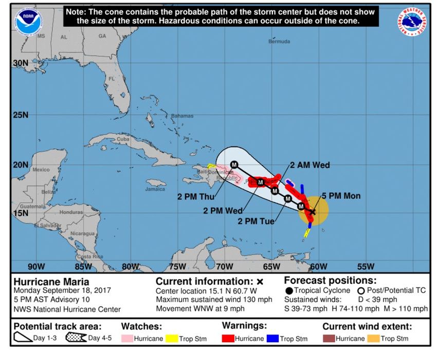
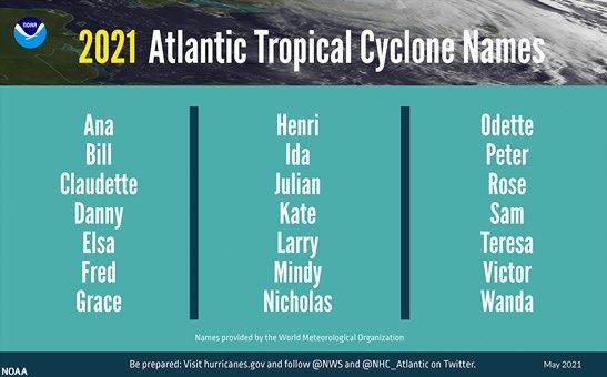
For 2021 the following names are given to the storms:

alphabetical list of the 2021 Atlantic tropical cyclone names as selected by the World Meteorological Organization. (NOAA)

Color Coded Warning System

The KNMI warning system consists of six (6) color coded warning phases indicating the severity of the conditions
and time left before a (potential) storm reaches the community.

Phase                                       Definition:

                                            No threat

Information                                 A Storm or Tropical Cyclone might threaten the community
--- Be Alert! ---                           within 48 tot 72 hours

Watch                                       Storm or Tropical Cyclone conditions might threaten the
--- Prepare Yourself! ---                   community within 48 hours

Warning                                     Storm or Tropical Cyclone conditions expected within the
--- Protect Yourself! ---                   next 36 hours

Strike                                      Storm or Tropical Cyclone conditions expected within 6 to 9
--- Seek Cover! ---                         hours

Advisory                                    Heavy rainfall and or rough sea conditions are expected. No
--- Carefull! ---                           Tropical Storm or hurricane is expected
Guideline: might means ≥ 10% chance, expected means ≥ 50% chance

During the Information phase (Yellow Phase) KNMI will provide 2 times per day a Tropical Cyclone Bulletin (TCB).
During the phases from “Watch” to “Strike” (Orange to Purple) this number increases to 4 times per day to
provide the latest available information. These phases and the TCB will be initiated by KNMI in coordination with
the National Hurricane Center (NHC). A TCB describes the warning, expected Wind, Rainfall and Maritime
conditions. The TCB will be in the English language. See the example on the next pages.

Important information websites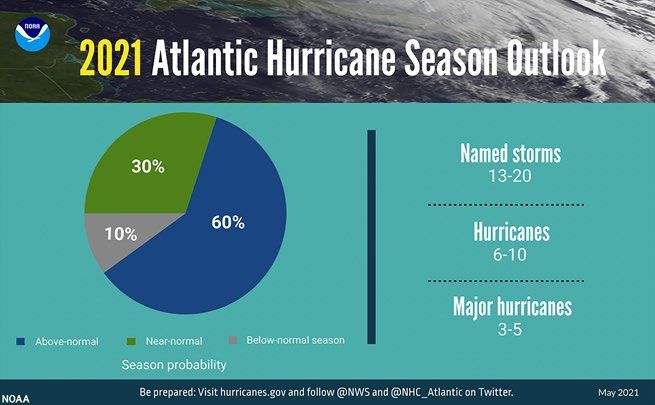
NOAA National Hurricane Center: http://www.nhc.noaa.gov
KNMI expectations and warnings: https://www.knmidc.org

Example Tropical Cyclone Bulletin

TROPICAL CYCLONE BULLETIN NO. 10

WARNING MESSAGE NO. 5
Date: Monday September 18, 2017 Time: 16:30 local time

Key Messages:

- Hurricane watch in effect for dangerous hurricane Maria

- Maria is expected to pass 70 miles (112 km) south of St. Eustatius on Tuesday September 19, 16:00

- Tropical storm winds are expected from Tuesday September 19, 12:00 until Wednesday September
  20, 06:00

- 20-30% risk Hurricane force winds (CAT-1, gusts 85 mph/140 km/h) from Tuesday September 19,
  18:00 until Wednesday September 20, 00:00

- Dangerous 25 ft high waves expected from Tuesday 06:00 till Wednesday 18:00, especially during
  the nearest approach on Tuesday 16:00

- Accumulated rainfall 4-6 inch, possibly up to 8 inch, forecasted with risk of life-threatening flash
  floods and mud slides

Effect on local conditions

Winds:
Tuesday morning easterly winds will increase to tropical storm conditions (maximum gusts 60 mph – 100 km/h)
and may continue till the early night to Wednesday. In this period there is a small risk (20-30%) for hurricane
wind conditions (CAT-1), with gusts up to 85 mph - 140 km/h from Tuesday afternoon. From Wednesday morning
wind speeds are expected to decrease to normal conditions. Wind will turn from East to South during Wednesday
afternoon and evening.

Seas:
A dangerous storm surge accompanied by large and destructive waves will raise water levels by as much as 6 to 9
ft above normal tide levels near where the center of Maria moves across the Leeward Islands.

Rainfall:
Maria is expected to produce total rain accumulations of 4 to 6 inches with isolated maximum amounts of 8
inches. Rainfall could cause life-threatening flash floods and mudslides.

Local authorities and residents of Saba and St. Eustatius are advised to continue monitoring the
further progress of this weather system and to take all necessary measures to safeguard life and
property.

Center's latest and forecast positions:

SABA:
Till Sat Sep 23 14:00 AST, the nearest position is estimated at:

Mon Sep 18 17:00 AST 15.1N 60.7W Category 4 Hurricane 390 km (243 mi) SE of Saba
Tue Sep 19 02:00 AST 15.7N 61.9W Category 4 Hurricane 258 km (160 mi) SE of Saba
Tue Sep 19 14:00 AST 16.5N 63.3W Category 4 Hurricane 126 km (78 mi) S of Saba
Wed Sep 20 02:00 AST 17.3N 64.7W Category 4 Hurricane 160 km (99 mi) WSW of Saba
Wed Sep 20 14:00 AST 18.2N 66.2W Category 4 Hurricane 320 km (199 mi) W of Saba
ST. EUSTATIUS:
Till Sat Sep 23 14:00 AST, the nearest position is estimated at:
Mon Sep 18 17:00 AST 15.1N 60.7W Category 4 Hurricane 360 km (224 mi) SE of St. Eustatius
Tue Sep 19 02:00 AST 15.7N 61.9W Category 4 Hurricane 230 km (143 mi) SSE of St. Eustatius
Tue Sep 19 14:00 AST 16.5N 63.3W Category 4 Hurricane 115 km (72 mi) SSW of St. Eustatius
Wed Sep 20 02:00 AST 17.3N 64.7W Category 4 Hurricane 184 km (114 mi) W of St. Eustatius
Wed Sep 20 14:00 AST 18.2N 66.2W Category 4 Hurricane 350 km (218 mi) WNW of St. Eustatius

Definitions:

HURRICANE WATCH: A warning for hurricane conditions, including sustained winds within the range ≥118 km/h
(≥ 74 mph) (≥64 knots) are possible in specified areas in 48 hours or less.

Next bulletin:

Monday September 18, 2017, 22:30 local time
You can also read