From natural to constructed: a proposal to estimate heat accumulation in metropolises - SciELO
←
→
Page content transcription
If your browser does not render page correctly, please read the page content below
From natural to constructed:
a proposal to estimate heat
accumulation in metropolises
Do natural ao construído: proposta
para estimar acúmulo de calor em metrópoles
Ruskin Freitas [I]
Jaucele Azerêdo [II]
Abstract Resumo
The transformation from a natural environment A transformação de um ambiente natural em um
to a built environment causes the formation ambiente construído ocasiona a formação de dife-
of different urban climates, according to urban rentes climas urbanos, de acordo com geometria
geometry, materials and activities. The objective urbana, materiais e atividades. O objetivo deste
of this article is to present a methodology to artigo é apresentar uma metodologia para se esti-
estimate heat accumulation in urban precincts, mar o acúmulo de calor em recintos urbanos, con-
according to the influence of ten climatic factors, siderando a influência de dez fatores climáticos,
assessed through values on a scale graduated into avaliados através de uma escala graduada em cin-
five levels: accumulation of negative, null, low, co níveis: acúmulo de calor negativo, nulo, baixo,
medium and high heat, the latter being able to médio e alto, podendo chegar a um total de seis
reach six positive degrees (+6.0°C) in relation to graus positivos (+6,0 °C), em relação àquele valor
the value verified in the reference meteorological verificado na estação meteorológica de referência.
station. The application of this methodology can A aplicação dessa metodologia, desenvolvida a
support comparisons between metropolises and partir de pesquisas diversas, poderá embasar com-
guide interventions aimed at user satisfaction, the parações entre metrópoles e orientar intervenções
efficiency of the built space and environmental que visem à satisfação do usuário, à eficiência dos
sustainability. espaços e à sustentabilidade ambiental.
Keywords: urbanization; spatial transformations; Palavras-chave: urbanização; climas urbanos;
urban climates; heat accumulation; Recife. acúmulode calor; Recife.
Cad. Metrop., São Paulo, v. 23, n. 50, pp. 331-354, jan/abr 2021 Artigo publicado em Open Acess
http://dx.doi.org/10.1590/2236-9996.2021-5013.e Creative Commons Atribution
Ruskin Freitas, Jaucele Azerêdo

Introduction                                        with the formation of urban climates. In
                                                    other words, the extent of possible social and
                                                    spatial transformation will affect changes in
Urbanization is characterized by the                the behavior of climatic elements differently
replacement of natural elements, such as            in different settings, in general, increasing air
a permeable ground surface, watercourses            temperature, reducing relative air humidity,
and vegetation, by built structures, such as        and changing the direction of winds. It should
impermeable surfaces, road systems and              be stressed that the degree of alteration in
building volumes. These transformations             climate parameters is directly proportional to
have been viewed from a variety of different        the changes brought about by climate change.
perspectives. The most common is to focus on               Simple comparison between the natural
the increase in population and the pressure         and the built environment or between the rural
increased population density exerts on nature       and the urban fails to take into account such
and society. According to data published by         changes. As Oke et al. (2017, p.168) put it, the
the 2017 edition of the World Population            process “involves… three sets of intertwined
Prospects report (United Nations, 2017, p. 1),      factors: thermal properties, moisture
by mid-2017, the world population stood at          availability of moisture, and geometric form”.
around 7.6 billion inhabitants. Of these, 55%       In other words, the absorption, storage and
lived in urban areas and it is estimated that, by   emission of heat depend on both natural
the middle of the 21st century, this percentage     and anthropogenic climate factors in such
will rise to 68%, representing a further 2.5        a way that the combination of materials,
billion city-dwellers between 2018 and 2050         elements and forms may give rise to widely
(United Nations, 2019, p. 1). The world             differing situations. We should also bear in
population of the future will thus be urban.        mind the main use for which the urban space
       Pires, Kneib & Ribeiro (2020, p. 248)        is intended, since the type of use (residential,
state that “the way these new inhabitants           commercial, or industrial) to which a space is
are accommodated in the territory has               put may predispose it to attract certain types
env iro nment al, s o c ial and e c o no mic        of activities and population groups. Each
ramifications”. Alvin, Kato & Rossin (2015, p.      setting should thus be considered in terms of
84), more specifically note that “urban sprawl      its own specific features.
generates numerous problems with serious                   Stewart & Oke (2012, p. 1885) conducted
consequences for society, such as soil sealing,     an extensive review of various studies of urban
alterations to the urban drainage system,           climate and came up with a new classification
climate change, and so forth”.                      of 17 homogeneous regions called ‘urban
       The transformation of the natural            climate zones’, varying from semi-urban to
environment into a built one causes an              heavily urbanized areas. “We formally define
increase in temperature and, consequently,          local climate zones as regions of uniform
heat accumulation, the intensity of which           surface cover, structure, material and human
depends on the elements, forms, activities          activity that span hundreds of meters to several
and a wide range of other factors associated        kilometers in horizontal scale,” they say.

332                                                       Cad. Metrop., São Paulo, v. 23, n. 50, pp. 331-354, jan/abr 2021
From natural to constructed: a proposal to estimate heat accumulation in metropolises

       However, in practice, such homogeneity                                generally collected at locations in which
is rare in the urban environment, especially                                 conditions approximate to those of the
in urban metropolises in Brazil, which                                       natural environment, with minimal influence
are typified by environmental diversity,                                     of human interventions (a natural ground
socioeconomic fragmentation, and multiple                                    surface, permeable to sun and wind).
urban parameters and institutional zones.                                          The atmospheric climate, when
This gives rise to a juxtaposition of distinct                               observed over a long period of time, is used as
morphological types, which are generally                                     the basis for climate studies, using time series,
small in s c al e. T h es e v ar i o u s ur b an                             normally covering 30 years of observations.
configurations in turn generate different                                    As Ayoade puts it (1991, p. 2), “climate is
levels of heat accumulation.                                                 a generalization, while weather deals with
       Stewart & Oke’s important study                                       specific events”. However, climate should not
(ibid.) characterizes, classifies and compares                               be taken solely to be the average behavior
different locations, and highlights the                                      of climate elements, but should also include
importance of the association between                                        its variations, a dynamic concept, as clearly
morphological characteristics and local                                      described in the work of Monteiro (1976).
climate measurements, thereby enabling                                             The urban climate “is a system that
them to show the inter-related influences                                    covers the climate of a given terrestrial space
of these diverse elements. However, it is                                    and its urbanization” (Monteiro; Mendonça,
important to contextualize and develop these                                 2003, p. 19). Depending on the discipline
and examine them in greater depth at local                                   involved and the aims of the investigation,
level. Almeida (2019, p. 61) notes that “the                                 urban climates may cover areas of various sizes
LCZ [local climate zone] system is generic and                               and numerous variables. The reference point
incapable of capturing the peculiarities of each                             adopted here concerns the diverse behavior of
and every urban or rural setting. The view of                                a set of climate elements divided up spatially
landscape is highly reductionist and, as with all                            according to their urban character, which may
classifications, its descriptive and explanatory                             be single or multiple, depending on natural
power is limited”.                                                           and anthropogenic climate factors.
       C l i m ate st u d i e s b e g i n w i t h t h e                            The formation of urban climates
observation of climate elements, measuring                                   is a fundamental topic for studies of
climate parameters such as air temperature,                                  environmental comfort in the fields of
relative air humidity, precipitation, wind                                   architecture and urbanism. Considering the
speed, and wind direction. Data relating to                                  case of heat comfort alone, the main reference
these climate features are collected at weather                              parameter – temperature – is influenced by
stations, updated practically in real time, and                              natural and anthropogenic climate factors and
published daily by the National Meteorological                               also by variation in other climate elements,
Institute – Inmet and the National Institute                                 such as precipitation, relative air humidity and
for Space Research – INPE. These data are                                    the speed and direction of the wind.

Cad. Metrop., São Paulo, v. 23, n. 50, pp. 331-354, jan/abr 2021                                                                        333
Ruskin Freitas, Jaucele Azerêdo
Anthropogenic climate factors include mild, especially when exposed to constant
building volumes, ground surface, urban moderate winds, of around 3m/s, according to
layout and human activities. These factors the Climate Norms for the 1981-2010 period
can modify the regional characteristics of published by the National Meteorological
the climate, on a variety of scales, forming Institute/Inmet.
urban mesoclimates and microclimates – local Supposing that, at a given time,
variations in the behavior of climate elements. atmospheric conditions are moderate, in a
One of the main results of these local changes non-urbanized almost natural area, in the
is the accumulation of heat. Curado neighborhood, for example, the
Various authors have examined this weather station situated in this neighborhood
subject in depth, conducting bibliographical and may register a temperature of 25.5°C. This
documentary research, as well as field studies, corresponds to characteristic regional means
involving direct observation and measurement for the hot, humid coastal tropical climate
of climate and environmental variables at of Recife, according to the Inmet. In other
various times of the year and detailed analyses parts of the city, the air temperature will not
showing the increase in temperature in urban be the same. In general, it will be slightly
settings. These authors include Monteiro higher. Various studies conducted by the
(1976), Landsberg (1981), Lombardo (1985), Environmental Comfort Laboratory – Lacam,
Mascaró (1996), Tarifa & Azevedo (2001), of the Federal University of Pernambuco –
Freitas (2008) and Azerêdo (2017). UFPE, specifically identifying the microclimatic
The capital of the State of Pernambuco is diversity at distinct locations by measuring
the object of study of this research. Its location climate variables, have revealed the possibility
between the Tropics of Cancer and Capricorn, that heat accumulation may amount to as
at latitude 8°23’ S, situates the city in the much as 6°C in Recife.
torrid zone of the planet, where the climate is In the case of analysis or studies
tropical. Being on the Eastern Atlantic coast of proposing interventions in certain parts of
Brazil, exposed to predominantly southeasterly the city, in different stages of urbanization,
trade winds, the climate is coastal in nature. the exclusive use of data collected in
More specifically, the region surrounding locations with the characteristics of a natural
Recife can be described as having a hot, environment, such as weather stations, does
humid coastal tropical climate, characterized not accurately reflect the behavior of climate
principally by high temperatures throughout elements in a highly urbanized setting,
the year and high relative air humidity, of because of the obvious differences in use,
around 80%, which helps to produce a reduced occupation, urban geometry and materials
temperature range, by mitigating extreme between the two areas.
temperatures. This lowers the maximum and As there is no network of stations that
increases the minimum temperatures, keeping could be used to measure air temperature
the annual average at around 26°C, considered and as it is hard to provide periodical
334 Cad. Metrop., São Paulo, v. 23, n. 50, pp. 331-354, jan/abr 2021From natural to constructed: a proposal to estimate heat accumulation in metropolises
systematic batches of measurements for 2) Air temperature – “measures the
each neighborhood or part of the city, a perceptible heat stored in it and is commonly
methodology needs to be developed that given in degrees Celsius or Fahrenheit and
provides an estimate of the temperature measured using a thermometer” (Mendonça
readings for each specific area for non- & Danni-Oliveira, 2009, p. 49). Considered a
scientific purposes. Identification of the type climate element, it is often used characterize
of area throughout the city and of the main a certain locality, using an instantaneous
features of the climate and of the urban measurement or daily, monthly or annual
morphology could provide an estimate of means. Air temperature varies in time and
the maximum temperature for each locality, space according to natural and anthropogenic,
relating the level of urbanization to degree of local and global climatic factors.
heat accumulation. 3) Heat – “variations in temperature are
The aim of this study is to present a due to a change in the thermal energy of a
methodology developed to estimate the system caused by the exchange of energy
maximum air temperature in a given urban between the system and its surroundings
locality (squares, plazas, crossroads, stretches [...] The energy transferred is called heat”. In
of road or avenue), based on ten climatic other words, heat “is the energy exchanged
factors. between a system and its surroundings
Taking as the point of reference the air owing to the difference in temperature”. The
temperature registered at the weather station, greater the difference in temperature, the
it can be assumed that an environment greater the quantity of energy exchanged
with the same natural and morphological between the media in question, until thermal
characteristics will have a similar air equilibrium is established. As heat is a
temperature. However, another environment, transferred energy, its unit of measurement
exposed to different local climatic factors with in the International System is the joule (J),
different morphological characteristics, will according to Halliday, Resnick & Walker
have a different air temperature, owing to (2012, pp. 191-193).
heat accumulation. 4) Heat accumulation – in the case of heat
The following concepts were outlined: accumulation, specifically, the reference
1) Temperature – is one of the central temperature measured Inmet weather
concepts of thermodynamics and one of the stations (automatic and conventional) is
seven base units of the International System essential. When evaluating the environment
(IS), measured using a thermometer. “Every using the ten climatic factors and measuring
body has a property called temperature. When the number of degrees Celsius (°C) heat
two bodies are in thermal equilibrium, their accumulation, this figure is added to the
temperatures are equal” (Halliday, Resnick & maximum air temperature recorded by
Walker, 2012, pp. 184-185). the weather station, to give the estimated
Cad. Metrop., São Paulo, v. 23, n. 50, pp. 331-354, jan/abr 2021 335Ruskin Freitas, Jaucele Azerêdo
temperature for the environment under a weather station or an urban locality. This
study. In an urban environment, therefore, radius, however, may vary, up or down,
heat accumulation is nothing more than the depending on conditions in the immediate
difference in temperature in degrees Celsius surroundings, be it the presence of natural
(°C), between the two environments, one of elements (bodies of water, masses of
which is the weather station, in the case of the vegetation, topographical variations), or
present article. changes in the urban form and that of built
The proposal, therefore, is to build a heat elements (urban geometry, building volumes,
accumulation scale of one to five: negative, road systems, and human activities).
zero, low, medium and high, as shown in Table Analysis of any urban locality should
1. These are estimates based on the potential consider various climatic factors that contribute
accumulation caused by each factor. separately to the estimated heat accumulation,
The estimated radius of influence depending on the intensity of socio-spatial and
here is 25 meters, which is the benchmark environmental transformations and the way
for characterization of climate elements at the climate elements influence it.
Table 1 – Influence of each climate factor on heat accumulation in urban settings
Estimated heat
Level of influence of climatic factors on air temperature behavior,
accumulation (°C) for each
affecting heat accumulation, in urban settings
local climate factor
Level One: a factor causes a reduction in air temperature, making conditions more like
- 0,25
a natural setting than those found at the weather station.
Level Two: a factor does not affect air temperature, meaning that the locality is
subject to low-intensity human intervention, with characteristics similar to a natural 0
environment.
Level Three: a factor causes a slight increase in air temperature, meaning that the
setting is subject to human intervention, and its characteristics differ from those of a + 0,25
natural environment.
Level Four: a factor causes an increase in air temperature, due to significant variation
in the behavior of climate elements and/or the configuration of morphological + 0,50
elements.
Level Five: a factor causes a large increase in air temperature, due to intensive
+ 0,75
anthropic intervention, with total loss of natural elements.
Source: Ruskin Freitas.
336 Cad. Metrop., São Paulo, v. 23, n. 50, pp. 331-354, jan/abr 2021From natural to constructed: a proposal to estimate heat accumulation in metropolises
Table 2 – Levels of heat accumulation according to ten local climate factors
Behavior of temperature, affecting heat Estimated heat accumulation (°C)
accumulation in urban localities caused by ten local climatic factors
Negative -1,5 to -0,25
Zero 0
Low 0,25 to 1,5
Medium 1,75 to 3,5
High 3,75 to 6,0
Source: Ruskin Freitas.
These factors are here reduced to the This methodology is based on direct
following ten: elevation, maritimity, density quantitative checklist-type evaluation for
of arboreal vegetation, wind permeability, each value. However, it is recommended
ground surface permeability, sunlight that it be accompanied by a more detailed
exposure, built-up density, uses and road qualitative analysis, taking into consideration
system, construction materials, and volumetric the reciprocal influences of the various
dynamics. The figures for heat accumulation factors.
for each of these factors (ranging from -0.5 These figures are based on the fact that,
to +0.75°C) give a maximum total of +6.0°C, in Recife, research carried out since 1997 has
in relation to the weather station’s maximum not found the heat accumulation in urban
daily temperature. localities to exceed 6°C. These studies were
Final characterization and classification carried out in neighborhoods such as Várzea,
of an urban locality should be based on the Casa Amarela, Encruzilhada, Água Fria, Boa
sum of the heat accumulation values for each Vista, Espinheiro, and others (Freitas, 2008;
one of the ten factors. The final sum can also Barros & Lombardo, 2013; Freitas & Azerêdo,
be placed on a five-point scale, in relation to 2014; França et al., 2015; Azerêdo, 2017;
the sum of values for all ten factors, and may Moreira et al., 2017).
register as negative, zero, low, medium or high Below, we outline the ten climatic factors
heat accumulation, as shown in Table 2. used in the study.
Cad. Metrop., São Paulo, v. 23, n. 50, pp. 331-354, jan/abr 2021 337Ruskin Freitas, Jaucele Azerêdo
Elevation are more exposed to the sun, but, at night,
the opposite may occur, “the lower parts
of valleys become warmer and drier than
Elevation is a vertical distance, measured
higher elevation areas, which remain better
in meters, between a certain point on the
ventilated due to the circulation of the
surface of the earth and the level of the
winds” (Schutzer, 2012, p. 84).
sea. On a local scale, this natural climate
Given that Recife’s weather station is
factor is often referred to as topography,
located at an approximate elevation of only
expanding the concept and the approach
10 meters, all the areas located at the same
beyond height, and also as ‘description of the
level and up to 20 meters have neutral heat
locality’, topographical variations and their
effects on climate elements, including other accumulation of around 0°C. The locations
climatic factors. with elevations between 20 and 80 meters, in
Elevation exerts an influence on Recife, are located on the surrounding arc of
atmospheric pressure, exposure to solar hills, to the north, west and southwest. Most
radiation and wind, temperature, humidity of these areas are densely occupied by low--
and precipitation. In particular, elevation income settlements, with little in the way of
has an inversely proportional affect on vegetation or open spaces. Above all, hill tops
temperature. This is due to decreased air and slopes to the east and southeast, exposed
density in higher layers of the atmosphere to the dominant winds, have a slightly lower
and also to the fact that the surface of the air temperature, of around 0.25°C.
earth emits heat, which has previously been Elevations above 80 meters are rare and
absorbed directly or through reflection, are mostly found in the far northwest of the
raising the heat nearer the surface. city, in the Guabiraba neighborhood, which is
On average, for every 100 meters of also sparsely populated with dense tree cover.
elevation, the air temperature falls 0.6°C In these remote locations, the elevation
(Ayoade, 1991, p. 53), and may fall as much lowers the air temperature by about 0.5°C.
as 1.0°C, depending on the gradient, the
orientation, the degree of exposure to Maritimity
sunlight and to ventilation and to the type
of ground surface cover. Hills, therefore, The term maritimity is used for a global climate
have temperatures slightly lower than the factor that refers to the influence of the seas
plains. The appropriation of the relief in and oceans on climate elements, as opposed
urban environmental design is a fact to be to continental masses. By analogy, this term is
appreciated, changing from one location also applied to a local climate factor, to refer
to another and at different times of the to the influence not only of oceans, but also
day. For instance, during the day, low- lakes, reservoirs and all large masses of water,
lying areas, located in a valley basin, may primarily on the temperature of the air and
be shaded, while higher elevation areas relative air humidity.
338 Cad. Metrop., São Paulo, v. 23, n. 50, pp. 331-354, jan/abr 2021From natural to constructed: a proposal to estimate heat accumulation in metropolises
Materials have specific heat properties, Using various points of reference, it
such as reflection or absorption. One of these is estimated that the oceanic coast up to
properties is specific heat. For Ferraro & Soares 100 meters inland and the banks of rivers
(1998, p. 283), “specific heat can be understood and lakes up to 30 meters, are subject to
as a numerical measure of the quantity of the influence of the sea, thereby reducing
heat that causes one unit of variation in air temperature by around 0.5°C. Areas
temperature on one unit of mass of substance”. downwind of such water masses have an area
In other words, it is the quantity of heat that is of influence twice as wide, although with
capable of causing one gram of a given material half the reduction in temperature, of around
to increase in temperature by 1°C. 0.25°C. As Recife’s weather station is situated
As the specific heat of water is higher one kilometer from the River Capibaribe and
than most types of soil, much more heat over 10 km from the Atlantic Ocean, this point
and more time is needed to increase the receives little influence from water masses.
temperature of aquatic surfaces than that of Similarly located points will not see a drop in
paved surfaces. Likewise, a longer period of temperature caused by this factor.
time will have elapsed before accumulated
heat is lost, causing significant differences in
temperature between land and water. These Density of arboreal vegetation
differences in the temperature of materials
cause differences in air temperature, Vegetation is composed of living beings and, as
atmospheric pressure and the production of such, has a metabolism and consumes energy,
wind, from areas of high pressure, with low which it derives from soil and sunlight. The use
air temperature, to areas of low pressure, of this energy for internal processes decreases
with high temperatures. Locations closer to the role of radiation that would otherwise be
water masses have lower temperatures, lower transformed into heat and transferred to the
temperature ranges, greater air humidity and environment. Vegetation is thus one of the
higher wind velocity. Ribeiro, Braz & Silva factors that moderate air temperature, acting
(2013, p. 5) calculate that the direct influence also on air humidity and the direction and
of the sea in terms of reducing temperature velocity of winds.
occurs in strip of land up to 140 meters wide. The evapotranspiration, grass and the
This figure varies according to the volume shade provided by trees are also ways in which
of water and the predominant direction vegetation lowers the temperature of surfaces
of winds. Carvalho (2018, p. 53) bases this and of the air.
calculation on the banks of bodies of water, Freitas (2008, p. 81) notes the role of
as outlined in Law n. 12,651/2012, in Brazil’s vegetation in the formation of microclimates
Forest Code. characterized by a reduction in temperature.
Cad. Metrop., São Paulo, v. 23, n. 50, pp. 331-354, jan/abr 2021 339Ruskin Freitas, Jaucele Azerêdo
Parks, squares, gardens, empty lots, and individual trees widely spaced out have low
the banks of rivers and canals, which are, in heat accumulation, of around 0.25°C, while
general, surrounded by buildings, stand out similar areas with widely spaced out trees
from their surroundings, behaving in terms and sparse canopy cover may experience
of climate more like a forest, although they medium heat accumulation, of around 0.5°C.
act only on smaller surfaces in their direct Areas devoid of tree cover will have high heat
proximity. Their spatial configuration conveys accumulation of around 0.75°C.
the Idea of an island of amenities.
In the case of predominantly urban
areas with a few public or private free spaces, Wind permeability
composed of clumps of arboreal vegetation,
such as parks, gardens or roadsides, there Winds have a fundamental effect on climate,
is a decrease in temperature. As Mascaró & because they help to disperse particles
Mascaró put it (2002, p. 49), “under clumps present in the atmosphere and to move heat
of trees, air temperature is 3°C to 4°C lower around through convection. In the case of
than in areas exposed to sunlight”. Azerêdo a hot, humid coastal tropical climate, wind
(2017, p. 429) have also noted the role is one of the main factors that reduce the
vegetation plays in reducing air temperature high temperature and humidity, making the
in its immediate surroundings, examining environment pleasant for users, both within
certain species of tree and showing that individual structures and in the city as a
the effect on temperature may extend as whole. More attention should thus be paid to
far as 90 meters downwind of a single tree. ventilation in urban planning.
It is thus essential to examine the species of In dealing with the ordering of cities,
trees, their size, density of foliage, canopy the dimensions and the format of public
volume, along with the speed and direction spaces – roads, avenues, parks and squares –,
of predominant winds. as well as their balanced distribution in the
Natural environments, with a high urban environment, affect permeability to the
density of arboreal vegetation, such as woods predominant winds, in terms of speed and
and forests, especially on the outskirts of cities, direction. In combination with the geometry
may help to produce temperatures lower than of the roadways, the characteristics of
those recorded by weather stations. buildings and the existing arboreal vegetation
Urban areas with arboreal vegetation, may or may not provide ventilation. The
especially compact or linear masses of shape, height, width and distance between
vegetation, with species with a dense canopy, buildings all determine the speed with
may have no effect on heat accumulation. On which the air flows between built masses.
the contrary, as trees are replaced by built Depending on the layout and shape of built
structures, areas with arboreal vegetation, volumes, these may pose barriers, provoke
with dense canopy cover, but with the turbulence, or channel air, along with various
340 Cad. Metrop., São Paulo, v. 23, n. 50, pp. 331-354, jan/abr 2021From natural to constructed: a proposal to estimate heat accumulation in metropolises
other aerodynamic effects. The tendency to Ground surface permeability
absorb and emit heat into the environment
is exacerbated when the shape of the urban The ground surface undergoes substantial
fabric does not allow the heat to dissipate. alteration with urbanization, especially when
From the city as a whole to its center, the permeable natural green surfaces are replaced
canyon shape also intensifies heat storage and by built structures surrounded by parking
may even form islands of heat, depending on lots, roads and paved surfaces and, hence,
various factors, according to studies that have impermeable spaces.
identified this phenomenon in specific places Soil sealing also modifies the natural
and at specific times. drainage system, causing water to be
Spaces completely free of barriers, distributed differently, both horizontally,
exposed to the winds, such as the seafront, between hydrographic basins, and vertically,
hilltops and spaces with no buildings nearby, redirecting rainwater, reducing evaporation
may possess negative heat accumulation, of up and infiltration, deep or superficial, and
to -0.25°C. Urban settings that are permeable increasing surface runoff. The water that falls
to the wind, such as river banks, hillsides as rain rapidly flows away off the surfaces of
facing the wind and open spaces with widely streets, avenues, forecourts, and even paved
spaced buildings allow the air to flow around canals, while they flow more slowly over
them and exhibit zero heat accumulation, very exposed or overgrown ground. The increased
near zero 0°C. Open urban spaces flanked runoff causes the environment to dry more
by buildings, with some space between quickly, reducing humidity and evaporation
them, enabling the wind to flow through, and raising temperatures.
with medium-sized clumps of arboreal As Boussoualim observes (2002, p. 35),
vegetation and high and/or sparse canopies, “in the city, there is much less evaporation.
are associated with low heat accumulation Most of the energy, which is not spent by
of around 0.25°C. Urban settings with little evaporation, serves to heat up the lower layers
space between built volumes and only a of the atmosphere and raise air temperature”.
few individual trees with dense canopies, The paved surfaces are very hot and further
blocking the wind, may occasion average heat increase the temperature of the air.
accumulation, close to 0.5°C. Urban settings A ground surface is considered
with single blocks or groups of blocks, forming permeable when it allows the infiltration of
barriers, with arboreal vegetation lining water and replenishment of the water table.
both sides of the road, with dense canopies It thus remains moist for longer and helps to
forming tunnels blocking the wind flow and reduce the surface temperature of covering
the dispersal of hot air, may experience high material and lowers the air temperature.
heat accumulation, close to 0.75°C. When the permeable ground is covered with
Cad. Metrop., São Paulo, v. 23, n. 50, pp. 331-354, jan/abr 2021 341Ruskin Freitas, Jaucele Azerêdo
vegetation, the mitigating effect of the natural of spaces on the scale of the whole city and
environment is heightened, as the metabolism that of individual buildings.
of the plants uses some solar radiation as The shape of the city, including road
energy, thus reducing its emission into the systems and built volumes, has a huge impact
surrounding area. on this factor. The orientation, length and
An urban setting with a predominantly width of roads in the road layout create
natural ground surface thus has zero heat greater or lower exposure to sunlight, as does
accumulation. its relation to the height and distribution of
Paved areas made of porous materials, building volumes.
such as ceramic tiles or cobblestones, and Katzschner (2007, p. 9) sees this factor
also those that intersperse permeable and as one of the most important in creating
impermeable stretches, may have low heat urban climates and even in the creation of
accumulation of about 0.25°C. heat islands in cities. A higher quotient for the
Partially paved areas and those paved relation between distance and height will have
with impermeable materials but interspersed a positive effect on heat and a negative effect
with some permeable stretches and/or porous on ventilation, in cold climates. On the other
materials, have average heat accumulation of hand, in hot, humid climates, if the distance
0.50°C. between buildings is greater than their height,
Areas that are fully paved with there is a positive effect on ventilation and
impermeable materials, especially materials a negative one on temperature, which a
with low specific heat and a high emissivity phenomenon that is much welcomed by city-
coefficient, such as concrete and asphalt, have -dwellers in such climates.
high heat accumulation of about 0.75°C. One way of viewing exposure to sunlight
is to see it in terms of the proportion of the
Exposure to sunlight sky that is visible, which, according to Souza
et al. (2010, p. 156), is a “non-dimensional
The sun is our main source of energy and one parameter, also called a configuration factor or
of the most important factors so far as heat angular factor”, which “indicates a geometrical
accumulation is concerned. Direct sunlight relation between the earth and the sky and
helps to increase the temperature, wear out represents and estimates of the area of
materials and produce glare, and may cause visible sky”, from any given point, on a street,
health problems. It is important to relate the a square, and so forth. All physical barriers
factors examined in this study one another, (buildings, vegetation, awnings and the like)
especially this one, since both high exposure to should be registered.
sunlight and the absence of it can be harmful, Urban areas with a width smaller than
from the point of view of climate, and, the mean height of surrounding buildings,
consequently, in relation to the salubriousness generates a visible sky factor lower than
342 Cad. Metrop., São Paulo, v. 23, n. 50, pp. 331-354, jan/abr 2021From natural to constructed: a proposal to estimate heat accumulation in metropolises
30°, which, in combination with the shade sustainability, optimizing use of space, because
provided by trees and awnings, yields very low of the proximity of residents, jobs, services
exposure to sunlight and a heat accumulation and facilities (Gauzin-Müller, 2011, p. 55).
close to 0°C. However, in a hot, humid tropical climate, this
Urban settings with a width similar to environmental initiative should be considered
the mean height of surrounding buildings with caution, as it has to be seen alongside
generate an angular factor of between 30 other climatic factors, such as the need for
and 60°. Depending on shade, this can lead natural ventilation to provide a comfortable
to low exposure to sunlight and low heat and salubrious environment.
accumulation of around 0.25°C. Increased built-up density is generally
In the case of areas whose width is associated with land clearance and soil sealing,
greater than the mean height of buildings, which help to raise the surface temperature
depending on shade, the visible sky factor lies and, thus, increase air temperature. When this
between 60 and 90°, causing medium heat density takes the form of very tightly packed
accumulation of around 0.5°C. Finally, urban buildings, with narrow streets, the urban areas
areas with width greater than the mean height produced are themselves confined and apt
of buildings, with no shade and an angular to store heat. When buildings are both close
factor of 90°, generate high exposure to together and high-rise, the heat accumulation
sunlight and high heat accumulation of around is compounded, since there is, at the same
0.75°C. time, an increase in air temperature and
a decrease in wind speed, which may also
give rise to the formation of heat islands.
Built-up density Freitas (2008, p. 119) provides reflection and
calculations regarding units of construction,
Built-up density refers to the total area of the number of inhabitants in a given region,
existing constructions divided by a certain and the area in hectares, classifying them and
surface area. The urbanization process relating population density to built-up density,
generally occurs in parallel with an increase in based on the following classes.
density of the built environment, which may be In areas similar to the surroundings of
by way of juxtaposition, as in historic areas and the weather station up to a situation in which
low-income settlements, with buildings very buildings are small and isolated, with a built
close to one another, or by superimposition of area much smaller than the total land area, it
a built area, as occurs in predominantly high- can be said that heat accumulation is zero.
-rise zones. These are the two main ways of In an already consolidated urban area,
increasing built-up density. with a population density of up to 72 people/
Increased urban density leads to a ha and single-story buildings, set apart from
compact urban configuration, which has one another, with some vacant lots, the heat
become one of the main principles of accumulation is low, around 0.25°C.
Cad. Metrop., São Paulo, v. 23, n. 50, pp. 331-354, jan/abr 2021 343Ruskin Freitas, Jaucele Azerêdo
In areas with increasing urban density, directly related to the density of vegetation,
with most lots occupied and the process of ground surface permeability, and other uses
high-rise development already underway, and activities. Recife’s Master Plan – Law
with a population density of between 72 17,511/2008, for example, classifies roads as
people/ha and 144 people/ha and a built area local, collector and arterial.
similar to the total area, heat accumulation is Local roads are found, primarily, in
around 0.5°C. residential zones, with mostly single-family
Very dense areas, with population residences, and low circulation of people and
density of over 144 people/ha, almost no vehicles. In general, these are dirt tracks or
space between buildings, significant high-rise cobbled, with a large amount of vegetation.
development and built-up density equal to Heat accumulation is thus near zero and the
twice the total land area, heat accumulation is local temperature is preserved.
considered to be high, at around 0.75°C. Collector roads are generally for mixed
use, with residences, stores and services,
Uses and road system increasing the flow of people and vehicles.
The land surface is waterproofed, but still
‘Uses’ refers to the way urban land is used, possesses some tree cover. These tend to
especially its use for construction and the kind be the main roads of a neighborhood and
of activities that can be conducted. On the normally have low heat accumulation of
broadest scale, we can identify rural and urban around 0.25°C. Secondary arterial roads
uses. Land for rural use has a large quantity of have intensive circulation of people and
permeable ground surface and low building vehicles and are situated in a predominantly
density, and low circulation of people and commercial area. They combine high built-up
vehicles, and generates less heat compared to density with low density of vegetation and
urban use. In cities, the main uses are housing, generally connect different neighborhoods
commerce and industry, all of which generate in the same city. They therefore exhibit
a certain flow of human beings, goods and medium heat accumulation of around 0.5°C.
services, whose production and circulation Main arterial roads are predominantly used
affect the climate, mainly by warming the for commerce and services, with large-scale
environment. Intensive energy consumption facilities (such as hypermarkets and hospitals),
in buildings (caused for example, by lighting a high throughput of people and even higher
and air conditioning), transport systems (which of vehicles, especially collective public
consume energy derived primarily from oil), transport. These combine an impermeable
industrial activity, commerce, services, and ground surface (asphalt or concrete) and high
human waste all contribute to the formation building density with very little vegetation.
and consolidation of the urban climate. They are usually the main roads of the city
The road system hierarchy is and form connections to other zones and, in
characterized by the size of the roadways the case of metropolitan regions, other cities,
(length and width), the number of lanes, and tend to have a high heat accumulation of
and the intensity of circulation, and is also around 0.75°C.
344 Cad. Metrop., São Paulo, v. 23, n. 50, pp. 331-354, jan/abr 2021From natural to constructed: a proposal to estimate heat accumulation in metropolises
Construction materials such as concrete latticework and vegetation,
especially trees, help to lower the temperature
All materials exchange heat with their in such environments.
surroundings in accordance with the Urban settings comprising low-rise
difference in temperature. Heat is transferred buildings, with façades in brickwork or clad
from ‘warmer’ materials to ‘colder’ ones, with ceramic tiles, set back from the road, with
until the thermal equilibrium of the system vegetation, hedges, railings and latticework,
is established. Heat exchange can occur in contribute little to heat accumulation, which
various ways, the main one being radiation, may be close to 0°C.
whereby a body emits heat energy, which can Urban settings with buildings of various
be absorbed by another body, even if there is heights, with brickwork or ceramic tile clad
empty space between them. Every material façades, set back from the road, with green or
causes a certain degree of heat exchange, permeable walls, contribute little in the way of
depending on its constitution, density, heat accumulation—around 0.25°C.
thickness, texture, and color (Frota; Schiffer, Open spaces with buildings and walls
1988, p. 31). made of various materials, absorbent or
The discussion here confines itself reflective, may be characterized by average
to construction materials used to build or emission of radiation, providing medium heat
clad walls surrounding lots or the façades accumulation of around 0.5°C.
of buildings surrounding a certain area. Spaces surrounded by predominantly
Depending on the physical properties of high-rise buildings, with high reflective walls,
reflection, transmission, absorption and made of dense and dark materials, generate a
emission, these materials, when heated by high accumulation of heat in urban settings, of
solar radiation and/or (direct or indirect) around 0.75°C.
radiation from other bodies, may affect
the temperature of urban environments.
Construction materials thus play a role in the Volumetric dynamics
formation of urban microclimates.
Smooth dense materials, with high Built volumes constitute a major anthropogenic
reflection and heat emission coefficients, climate factor, because of the soil sealing of
such as concrete, granite and stone, and dark the ground they occupy and because of their
ones, such as asphalt, which absorb a large interference in the surroundings. Because of the
part of the radiation and reflect it back into properties of their materials, they increase air
the environment, as part of the heat exchange temperature and reduce relative air humidity.
process, help to increase the temperature of According to their shape, width, length, height
urban settings. Porous more highly textured and position, they alter the direction and speed
materials, such as certain kinds of ceramic of winds, and produce aerodynamic effects.
tile, and elements with apertures and cavities, Volumes cast shadows that may fall on other
Cad. Metrop., São Paulo, v. 23, n. 50, pp. 331-354, jan/abr 2021 345Ruskin Freitas, Jaucele Azerêdo
buildings. A building may also cast a shadow on volumes and shapes with mostly flat surfaces
itself, depending on its volumetric dynamics, exhibit average radiation emission, causing
heating or cooling surfaces external to it and medium heat accumulation of up to 0.5°C.
affecting heat accumulation in the area, owing Urban settings that are completely enclosed
to interplay of various possible reflections of by buildings with no diversity of volumes or
heat energy from one façade to another and to forms, with smooth façades and high reflective
the surrounding open spaces. walls, characterized by high radiation emission
For the purposes of heat accumulation produce high heat accumulation of around
estimation, volumetric dynamics will be 0.75°C.
based on the various buildings that comprise The photographs of two distinct
a certain urban district. For example, façades locations shown below more clearly illustrate
can be smooth or coarse, with recesses and these points. Figure 1 shows a location
protrusions, which may serve as balconies, in the Linha do Tiro neighborhood, in the
helping to provide shade for the façade itself. northern part of the City of Recife/PE, which
Alternating sunlight and shade cause has an elevation of around 40 meters, lies
variations in temperature, which, in turn, approximately 6 km from the Atlantic Ocean,
help wind circulation and mitigate the has average tree coverage, is permeable to
environmental discomfort characteristic wind, with permeable ground surface, average
of our hot, humid coastal tropical climate. exposure to sunlight, low built-up density,
The volumetric dynamics can also create local roads for residential use, materials
alternative living spaces, because of the with medium reflective potential and a fairly
apparent passage of the sun over the surface dynamic volumetrics. All of this adds up to low
of the earth. These spaces may be comfortable heat accumulation.
or uncomfortable, depending on their Figure 2 shows an urban setting in the
exposure to sunlight (Romero, 2001, p. 88). Boa Vista neighborhood, also in Recife/PE, with
Urban settings shaped by buildings the following characteristics: low elevation,
that are highly dynamic volumetrically, with continentality, low density of tree cover, wind
recesses and protrusions, balconies, eaves, permeability, impermeable ground surface,
awnings, brise-soleils and/or marquees, do medium exposure to sunlight, high built-up
not greatly increase temperature. These density, arterial road with mixed use, materials
may considered to generate very low heat with intermediate reflectivity, poor volumetric
accumulation of almost 0°C. Settings shaped by dynamics. These characteristics generate high
buildings and walls characterized by a diversity heat accumulation.
of volumes and shapes, with a moderate Figure 3 shows the municipality of Recife/
quantity of recesses and protrusions, may be PE and its neighborhoods. The predominance
considered to emit low levels of radiation and of natural elements lowers heat accumulation
cause low heat accumulation of approximately in some urban settings, such as those located
0.25°C. Urban settings shaped by buildings in Apipucos, Linha do Tiro, Curado, University
and walls characterized by a diversity of Campus and on the Boa Viagem seafront. The
346 Cad. Metrop., São Paulo, v. 23, n. 50, pp. 331-354, jan/abr 2021From natural to constructed: a proposal to estimate heat accumulation in metropolises
Figure 1 – Linha do Tiro, Recife – PE
Source: Ruskin Freitas (2016).
Figure 2 – Boa Vista, Recife – PE
Source: Ruskin Freitas (2018).
Cad. Metrop., São Paulo, v. 23, n. 50, pp. 331-354, jan/abr 2021 347Ruskin Freitas, Jaucele Azerêdo
Table 3 – Examples of estimated heat accumulation (°C) in urban localities
Climatic factors
Ground surface
Heat
Uses and road
Urban
Construction
permeability
permeability
vegentation
Exposure to
accumulation
Volumetric
Maritimity
Density of
location
dynamics
materials
Elevation
0ºC
sunlight
Built-up
density
system
Wind
-1,25
-0,25 -0,5 -0,25 -0,25 0 0 0 0 0 0
Negative
Apipucos
0
0 0 0 0 0 0 0 0 0 0
Zero
Weather station
Curado
+0,50
0 0 0 0 0 0,25 0 0,25 0 0
Low
Cidade Universitária
+0,75
0 -0,5 0,25 -0,25 0,25 0,25 0,25 0,25 0,25 0
Low
Boa Viagem
+2,50
0 0 0,25 0,5 0,5 0 0,5 0,25 0,25 0,25
Medium
Boa Vista
+4,00
0 0 0,75 0 0,75 0,75 0,25 0,75 0,5 0,25
High
Imbiribeira
Source: Ruskin Freitas.
348 Cad. Metrop., São Paulo, v. 23, n. 50, pp. 331-354, jan/abr 2021From natural to constructed: a proposal to estimate heat accumulation in metropolises
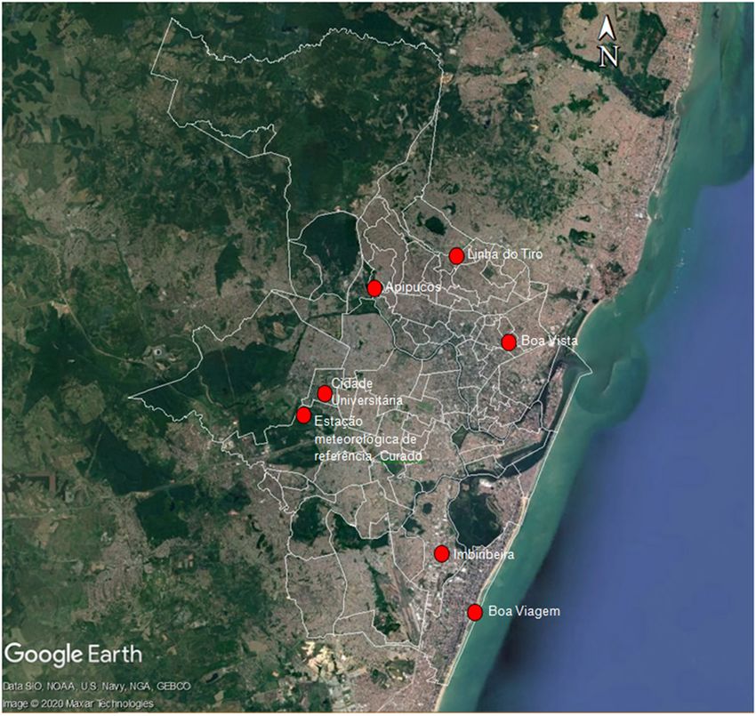
Figure 3 – Recife – PE, showing the location mentioned in Figures 1 and 2 and Table 3
Source: Jaucele Azerêdo, based on images from Google Earth and Recife City Hall. Retrieved from http://dados.
recife.pe.gov.br/dataset/area-urbana/resource/e43bee60-9448-4d3d-92ff-2378bc3b5b00, access in: 31 August
2020.
Cad. Metrop., São Paulo, v. 23, n. 50, pp. 331-354, jan/abr 2021 349Ruskin Freitas, Jaucele Azerêdo
predominance of built elements leads to high local climatic factors have been presented as
heat accumulation in other urban settings, points of reference, all of which are capable
such as those in Boa Vista and Imbiribeira. of altering heat accumulation in a certain
urban setting. These are elevation, maritimity,
density of arboreal vegetation, wind
permeability, ground surface permeability,
Concluding remarks exposure to sunlight, built-up density, uses
and road system, construction materials and
Given the complexity of the urban climate volumetric dynamics.
system and the wide range of variables involved, The tactic was thus to develop a
studies of each space under analysis and/ methodology for estimating the heat
or subject to intervention is of fundamental accumulation caused by the combined
importance prior to any initial reports and/or effect of these factors, as a way to improve
proposals being drawn up. It should be noted knowledge of this subject and, moreover,
that, because of the operational difficulties assist urban planning. It should be noted that
involved in any environmental characterization, the variables and values outlined here are not
it will not always be possible to make detailed the only ones, but these should provide a clear
systematic measurements of climate elements enough view for comparison of locations and
in urban settings. surveying them prior to intervention.
One fairly viable way of producing a The heat accumulation estimated for
preliminary characterization of an area would each factor was placed on a scale at intervals
be to visit the area and draw up a map of of 0.25°C and classified into five levels, from
thermo-environmental comfort, using field -0.5 to +0.75, corresponding to negative, zero,
research, observation and perceptions. This low, medium and high heat accumulation.
would involve providing a special representation Likewise, the final classification of any
of the sensation of heat, using colors (such one location should take into account the sum
as blue for relatively comfortable zones, of the heat accumulation values for each of
red for uncomfortable zones and yellow for ten factors. The final figure, between -1.5°C
intermediate zones), according to the physical and +6°C, can also be placed on the same five-
characteristics of the geographical area. point scale and compared with the maximum
Another alternative would be to use air temperature recorded at the Inmet
measurements from a natural environment weather station, which is used to represent
(such as those of a weather station) and the supposed regional temperature.
observation of local, natural and human-made, It is clear that this methodology could be
climatic factors to estimate the temperature subject to change. It is important, in a more in-
in an environment transformed by human depth analysis, to relate various positive and
beings, thereby characterizing a rich urban negative heat accumulation factors, noting
diversity, in terms both of morphology and the way they interfere with and influence each
of environment and climate. To this end, ten other. Such an evaluation is no substitute
350 Cad. Metrop., São Paulo, v. 23, n. 50, pp. 331-354, jan/abr 2021From natural to constructed: a proposal to estimate heat accumulation in metropolises
for in-depth research and systematic spaces, both in terms of the comfort of the
measurement of atmospheric, structural and environment for users of internal spaces and
urban conditions, for the purposes of urban for the interfaces between different systems.
planning, building projects and improving More in-depth and extensive investigation of
the comfort of the environment. However, these local climate changes may also help us
if a preliminary evaluation is needed, this to assess the contribution of these to climate
evaluation will be extremely useful. Studies in changes at a global level.
this field have also been shown to be important If, in a city such as Recife, with a
for reviews of urban planning and building municipality of 1.7 million inhabitants and a
legislation, as such studies show the extent to Metropolitan Region of more than 4 million,
which each element of an urban environment there is a difference of up to 6°C between
contributes to heat accumulation. locations within this area, it should also be
For example, if a certain area goes possible, by analogy, to calculate the heat
through an intensive period of urbanization, accumulation for other localities, principally
along with an increase in population density, those of a metropolitan character, in which
high-rise development and soil sealing, there environmental, morphological and socio-
will probably be an increase in temperature economic differences are exacerbated.
and loss of environmental quality. With the This methodology can be used by
application of the methodology presented urban managers and technical staff, or even
here, it is possible to simulate scenarios and by students and ordinary citizens, to guide
estimate the difference in temperature by interventions that aim to improve user
estimating the heat accumulation before and satisfaction, the efficiency of built space and
after the proposed changes. This would cover environmental sustainability. The expectation
factors such as increased levels of natural is that other studies will be conducted both to
ground surface, reduced levels of occupation, consolidate the concepts developed here for
and larger gaps between buildings. a hot, humid coastal tropical climate and to
Heat accumulation in urban spaces develop others for different morphological and
directly interferes with the quality of open environmental contexts.
Cad. Metrop., São Paulo, v. 23, n. 50, pp. 331-354, jan/abr 2021 351Ruskin Freitas, Jaucele Azerêdo
[I] https://orcid.org/0000-0001-7347-8302
Universidade Federal de Pernambuco, curso de Arquitetura e Urbanismo, Programa de Pós-Gradua
ção em Desenvolvimento Urbano. Recife, PE/Brasil.
ruskin37@uol.com.br
[II] https://orcid.org/0000-0002-5853-8052
Universidade Federal de Pernambuco, curso de Arquitetura e Urbanismo, Recife, PE/Brasil.
jaucele_azeredo@hotmail.com
Translation: this article was translated by Peter Ratcliffe, peter@sharingenglish.com.br
References
ALMEIDA, E. M. A. (2019). A cidade como um sistema complexo: transformações morfológicas e
climáticas em Maceió. Tese de doutorado. Maceió, Universidade Federal de Alagoas.
ALVIN, A. T. B.; KATO, V. R. C.; ROSSIN, J. R. G. (2015). A urgência das águas: intervenções urbanas em
áreas de mananciais. Cadernos Metrópole. São Paulo, v. 17, n. 33, pp. 83-107.
AYOADE, J. O. (1991). Introdução à climatologia para os trópicos. Rio de Janeiro, Bertrand do Brasil.
AZERÊDO, J. F. F. A. (2017). Verde que te quero confortável: a contribuição da arborização urbana para
o conforto termoambiental ao nível do usuário pedestre. Tese de doutorado. Recife, Universidade
Federal de Pernambuco.
BARROS, H. R.; LOMBARDO, M. A. (2013). Zoneamento climático urbano da cidade do Recife: uma
contribuição ao planejamento urbano. GEOUSP – espaço e tempo. São Paulo, n. 33, pp. 187-197.
BOUSSOUALIM, A. (2002). Contribuition à la caracterérisations de l’impact et de l’incidence du
microclimat sur l’usage et les activités em espace public exterior – étude de cas à Blangnac. Thèse
de doctorat. Nantes, École Polytechnique.
CARVALHO, L. T. (2018). Mapas climáticos: instrumentos para o planejamento urbano. Trabalho de
Conclusão de Curso. Recife, Universidade Federal de Pernambuco.
FERRARO, N. G.; SOARES, P. A. T. (1998). Física básica. São Paulo, Atual.
FREITAS, R. (2008). Entre mitos e limites: as possibilidades do adensamento construtivo face à qualidade
de vida no ambiente urbano. Recife, Editora Universitária da UFPE.
FREITAS, R.; AZERÊDO, J. (2014). A disciplina conforto ambiental: uma ferramenta prática na concepção
de projetos de arquitetura, de urbanismo e de paisagismo. Cadernos Proarq. Rio de Janeiro, n. 20,
pp. 94-113.
352 Cad. Metrop., São Paulo, v. 23, n. 50, pp. 331-354, jan/abr 2021You can also read