Fisheries assessment of Castlebanny wind farm, Mullinavat, Co. Kilkenny
←
→
Page content transcription
If your browser does not render page correctly, please read the page content below
Fisheries assessment of Castlebanny wind
      farm, Mullinavat, Co. Kilkenny

         Prepared by Triturus Environmental Ltd. for Blackthorn Ecology

                                         December 2020

________________________________________

Please cite as:

Triturus (2020). Fisheries assessment of Castlebanny wind farm, Mullinavat, Co. Kilkenny. Report prepared
by Triturus Environmental Ltd. for Blackthorn Ecology. December 2020.

  Castlebanny wind farm fisheries assessment 2020                                                           1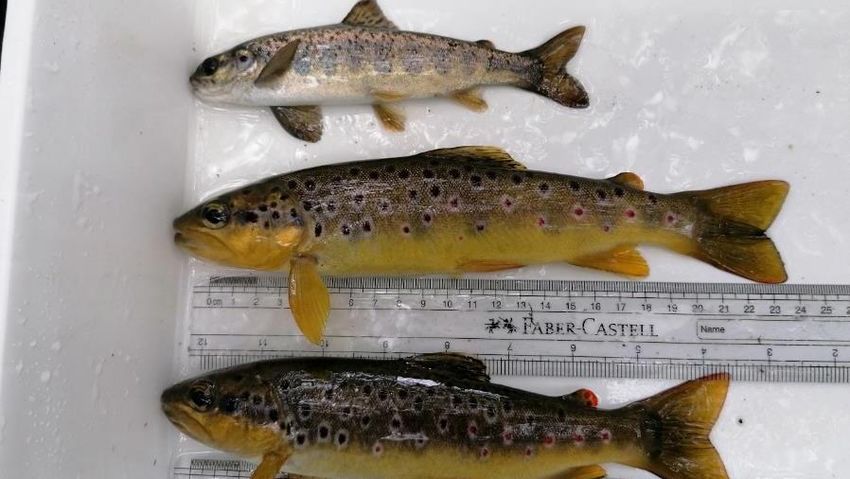
Table of contents
1.     Introduction                                    3
1.1 Background                                          3
1.2 Fisheries asset of the survey area                  3
2.     Methodology                                     4
2.1 Fish stock assessment (electro-fishing)             4
2.2 Fisheries habitat                                   7
2.3 Biosecurity                                         8
3.     Results                                         9
3.1 Fish stock assessment (electro-fishing)             9
3.2 Fisheries habitat                                  28
4.     Discussion                                      30
4.1 Most valuable sites                                30
5.     References                                      32

     Castlebanny wind farm fisheries assessment 2020        2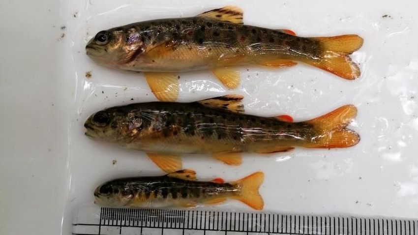
1.    Introduction

1.1   Background

Triturus Environmental Ltd. were contracted by Blackthorn Ecology (on behalf of Tobin Consulting
Engineers) to conduct a fisheries assessment along numerous watercourses in the footprint of
the proposed Castlebanny wind farm near Mullinavat, Co. Kilkenny.

A total of n=13 survey sites were located on the Arrigle Trib 1 Stream (EPA code: 15A30), Arrigle
Trib 3 Stream (15A32), Mullenhakill Stream (15M51), Arrigle River (15A02), Garrandarragh Stream
(15G81), Ballytarsna River (15B66), Crowbally Stream (16C76), River (Kilmackow) Blackwater
(16B02), Jerpoint Stream Stream (15J06) and an unnamed Mullenhakill Stream tributary. These
electro-fishing survey sites included proposed grid connection route crossings of the Mullenhakill
Stream, Arrigle River and the Garrandarragh Stream (see Chapter 6 of accompanying EIAR report).

In order to gain an accurate overview of the existing and potential fisheries value of the riverine
watercourses within the footprint of the proposed development, a catchment-wide electro-
fishing survey across n=13 sites was undertaken in July 2020. Electro-fishing helped to identify
the importance of the watercourses as nurseries and habitats for salmonids, lamprey and
European eel (Anguilla anguilla), as well as other fish species, and helped to further inform impact
assessment and any attendant mitigation for the wind farm development.

1.2   Fisheries asset of the survey area

The proposed Castlebanny wind farm development encompasses numerous small streams and
rivers in Co. Kilkenny, located in the Blackwater (Kilmacow)_010, Arrigle, 010, Arrigle_020 and
Nore_220 WFD sub-catchments within the wider Nore and Suir catchments, respectively.

The Arrigle River is a major lowland tributary of the River Nore and is known to support a range
of fish species, including brown trout (Salmo trutta), Atlantic salmon (Salmo salar) and European
eel (Anguilla anguilla) (Sullivan, 2007). Sea lamprey (Petromyzon marinus) are known from the
Arrigle (Kurz & Costello, 1999; NPWS data) although no juveniles were recorded in targeted
surveys undertaken in 2004 and 2008 (Gargan et al., 2011; SRFB, 2008). Other lamprey
ammocoetes (Lampetra sp.) are also known from the Arrigle (Kurz & Costello; SRFB, 2008; NPWS
data).

Fisheries data for the other watercourse within the survey area was largely lacking. However, the
wider River Nore catchment is known to support Atlantic salmon, sea trout (Salmo trutta), brown
trout, stone loach (Barbatula barbatula), minnow (Phoxinus phoxinus), European eel, gudgeon
(Gobio gobio), perch (Perca fluviatilis), pike (Esox lucius), three-spined stickleback (Gasterosteus
aculeatus) and the non-native, invasive species roach (Rutilus rutilus) and dace (Leuciscus
leuciscus) (Kelly et al., 2015, 2010). The River Blackwater (Kilmacow) sub-catchment, itself part of
the wider Suir catchment, is known to support river/brook lamprey (Lampetra sp.) (O’Connor,
2007), as well as salmonid populations.

  Castlebanny wind farm fisheries assessment 2020                                                      3
2.    Methodology

2.1   Fish stock assessment (electro-fishing)

A single anode Smith-Root LR24 backpack (12V DC input; 300V, 100W DC output) was used to
electro-fish sites on both named and unnamed watercourses in the footprint of the proposed
Castlebanny wind farm over the course of Thursday 9th July and Saturday 11th July 2020, following
notification to Inland Fisheries Ireland (Clonmel) and under the conditions of a Department of
Communications, Climate Action & Environment (DCCAE) license. The catchment-wide electro-
fishing (CWEF) survey was undertaken across n=13 sites (Table 2.1, Figure 2.1). Length frequency
graphs and species composition graphs for all species with numbers captured are illustrated in
the Results section.

Both river and holding tank water temperature was monitored continually throughout the survey
to ensure temperatures of 20°C were not exceeded, thus minimising stress to the captured fish
due to low dissolved oxygen levels. A portable battery-powered aerator was also used to further
reduce stress to any captured fish contained in the holding tank. Salmonids, European eel and
other captured fish species were transferred to a holding container with oxygenated fresh river
water following capture. To reduce fish stress levels, anaesthesia was not applied to captured
fish. All fish were measured to the nearest millimetre and released in-situ following a suitable
recovery period.

As three primary species groups were targeted during the survey, i.e. salmonids, lamprey, and
eel, the electro-fishing settings were tailored for each species. By undertaking electro-fishing
using the rapid electro-fishing technique (see methodology below), the broad characterisation of
the fish community at each sampling reach could be determined as a longer representative length
of channel can be surveyed. Electro-fishing methodology followed accepted European standards
(CEN, 2003) and adhered to best practice (e.g. CFB, 2008).

2.1.1 Salmonids, European eel and cyprinids

For salmonid species and European eel, as well as other incidental species, electro-fishing was
carried out in an upstream direction for a 10-minute CPUE, an increasingly common standard
approach for wadable streams (Matson et al., 2018). A total of approx. ≥100m channel length was
surveyed at each site, where feasible, in order to gain a better representation of fish stock
assemblages. At some minor watercourse sites or sites with limited access, it was more feasible
to undertake electro-fishing for a 5-minute CPUE. Discrepancies in fishing effort (CPUE) between
sites are accounted for in the subsequent results section (Table 3.1).

Relative conductivity of the water at each site was checked in-situ with a conductivity meter and
the electro-fishing backpack was energised with the appropriate voltage and frequency to provide
enough draw to attract salmonids and European eel to the anode without harm. For the low to
moderate conductivity waters of the sites (most draining upland areas) a voltage of 220-275V,
frequency of 40-45Hz and pulse duration of 3.5ms was utilised to draw fish to the anode without
causing physical damage.

  Castlebanny wind farm fisheries assessment 2020                                                   4
2.1.2 Lamprey
Electro-fishing for lamprey ammocoetes was conducted using targeted box quadrat-based
electro-fishing (as per Harvey & Cowx, 2003) in objectively suitable areas of sand/silt, where
encountered. As lamprey take longer to emerge from silts and require a more persistent
approach, they were targeted at a lower frequency (30Hz) burst DC pulse setting which also
allowed detection of European eel in sediment, if present. Settings for lamprey followed those
recommended and used by Harvey & Cowx (2003), APEM (2004) and Niven & McAuley (2013).
Using this approach, the anode was placed under the water’s surface, approx. 10–15 cm above
the sediment, to prevent immobilising lamprey ammocoetes within the sediment. The anode was
energised with 100V of pulsed DC for 15-20 seconds and then turned off for approximately five
seconds to allow ammocoetes to emerge from their burrows. The anode was switched on and off
in this way for approximately two minutes. Immobilised ammocoetes were collected by a second
operator using a fine-mesh hand net as they emerged.
Lamprey species were identified to species level, where possible, with the assistance of a hand
lens, through external pigmentation patterns and trunk myomere counts as described by Potter
& Osborne (1975) and Gardiner (2003).
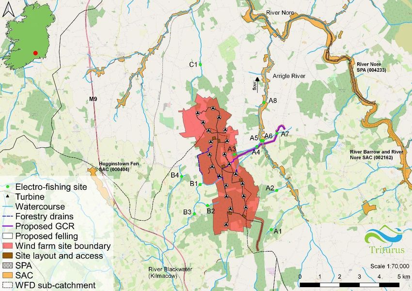
Table 2.1 Electro-fishing survey site locations in the footprint of the proposed Castlebanny wind
farm, Co. Kilkenny.
Site no. Watercourse EPA code Location / townland ITM (x) ITM (y)
A1 Arrigle Trib 1 15A30 Glenpipe 660741 628657
A2 Arrigle Trib 3 15A32 Glenpipe 661014 630635
A3 Unnamed stream n/a Cappagh 658882 632459
A4 Mullenhakill Stream 15M51 Cappagh 660015 632848
A5 Arrigle River 15A02 Coolnahau 660240 633149
A6 Garrandarragh Stream 15G81 Garrandarragh 660323 633151
Unnamed bridge,
A7 Garrandarragh Stream 15G81 661025 633519
Garrandarragh
A8 Arrigle River 15A02 Ballycorcoran Bridge 660371 635079
B1 Ballytarsna River 15B66 Ballytarsna 657150 630931
B2 Crowbally Stream 16C76 Ballytarsna 657526 629873
B3 Ballytarsna River 15B66 Ballytarsna 656859 629454
B4 River Blackwater 16B02 Castlegannon 656213 631337
C1 Jerpoint Church Stream 15J06 Ballyconway Bridge 657163 636993
Castlebanny wind farm fisheries assessment 2020 5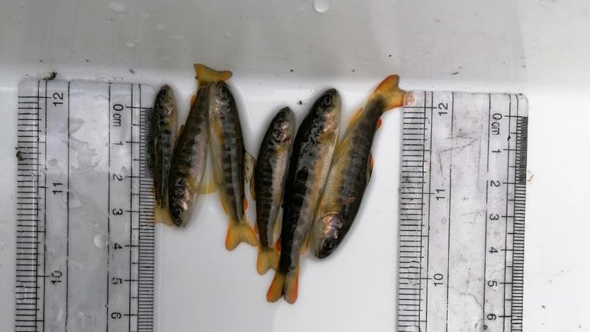
Figure 2.1 Location overview of the n=13 electro-fishing sites in vicinity of the proposed Castlebanny wind farm, Co. Kilkenny, July 2020

                               Castlebanny wind farm fisheries assessment 2020                                                 6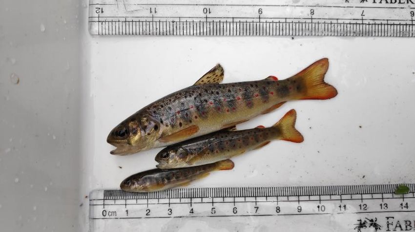
2.2    Fisheries habitat

2.2.1 Salmonids

Fisheries habitat quality for salmonids was assessed using the Life Cycle Unit method (Kennedy,
1984; O’Connor & Kennedy, 2002) to map the n=13 riverine sites as nursery, spawning and
holding habitat, by assigning quality scores to each type of habitat. Those habitats with poor
quality substrata, shallow depth and a poorly defined river profile receive a higher score. Higher
scores in the Life Cycle Unit method of fisheries quantification are representative of poorer value,
with lower scores being more optimal despite this appearing counter-intuitive.

Table 2.1 Life Cycle Unit scoring system for salmonid nursery, spawning and holding habitat value
(as per Kennedy, 1984 & O’Connor & Kennedy, 2002)

                                                Total score
  Habitat quality       Habitat score
                                            (three components)
        Poor                  4                      12
      Moderate                3                     9-11
       Good                   2                      6-8
      Excellent               1                      3-5

2.2.2 Lamprey

Lamprey habitat evaluation for each survey site was undertaken using the Lamprey Habitat
Quality Index (LHQI) scoring system, as devised by Macklin et al. (2018). The LHQI broadly follows
a similar rationale as the Life Cycle Unit score for salmonids. Those habitats with a lack of soft,
largely organic sediment areas for ammocoete burrowing, shallow sediment depth (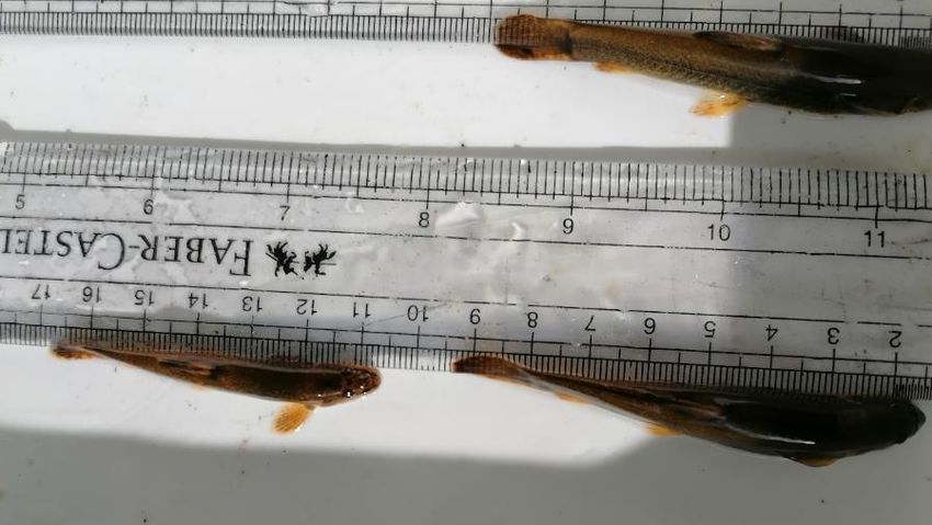
or twigs in areas of deposition. Type 2 habitat is characterized by substrates consisting of shifting
sand with little if any organic matter and may also contain some gravel and cobble (lamprey may
be present but at much lower densities than Type 1). Type 3 habitat consists of materials too hard
for larvae to burrow including bedrock and highly compacted sediment. This classification can
also be broadly applied to other lamprey species ammocoetes, including Lampetra species.

Table 2.2 Lamprey Habitat Quality Index (LHQI) scoring system for lamprey spawning and nursery
habitat value (Macklin et al., 2018).

                                                Total score
  Habitat quality       Habitat score
                                             (two components)
        Poor                  4                       8
      Moderate                3                      6-7
       Good                   2                      3-5
      Excellent               1                       2

2.2.3 General fisheries habitat

A broad appraisal / overview of the upstream and downstream habitat at each site was also
undertaken to evaluate the wider contribution to salmonid and lamprey spawning and general
fisheries habitat. River habitat surveys and fisheries assessments were also carried out utilising
elements of the approaches in the River Habitat Survey Methodology (Environment Agency,
2003) and Fishery Assessment Methodology (O’Grady, 2006) to broadly characterise the river
sites (i.e. channel profiles, substrata etc.).

2.3    Biosecurity

A strict biosecurity protocol following the Check-Clean-Dry approach was employed during the
survey. Equipment and PPE used was disinfected with Virkon® between survey sites to prevent
the transfer of pathogens and/or invasive species between survey areas. Where feasible,
equipment was also be thoroughly dried (through UV exposure) between survey areas. As per
best practice, surveys were undertaken at sites in a downstream order (i.e. uppermost site
surveyed first etc.) to prevent the upstream mobilisation of invasive propagules and pathogens.
Any invasive species recorded within or adjoining the survey area were geo-referenced.

  Castlebanny wind farm fisheries assessment 2020                                                       8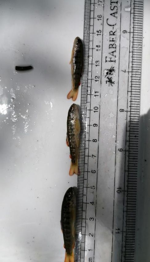
3.    Results

A catchment-wide electro-fishing survey of n=13 sites in the footprint of the proposed
Castlebanny wind farm was conducted over Thursday 9th July and Saturday 11th July 2020
following notification to Inland Fisheries Ireland (Clonmel). The results of the survey are discussed
below in terms of fish population structure, population size and the suitability and value of the
surveyed areas as nursery and spawning habitat for salmonids, European eel and lamprey species.
Scientific names are provided at first mention only. Representative fish images are provided in
Appendix A of this report.

3.1   Fish stock assessment (electro-fishing)

3.1.1 Site A1 – Arrigle Trib 1 Stream, Glenpipe

No fish were recorded during electro-fishing at site A1. The stream was semi-dry at the time of
survey with only a slight flow and depths of ≤0.05m (July 2020). The site was not capable of
supporting resident fish. The stream may be utilised by brown trout and European eel during
periods of higher flow (e.g. autumn, winter) although its overall fisheries value was considered
low given likely seasonality.

3.1.2 Site A1 – Arrigle Trib 2 Stream, Glenpipe

A total of two fish species were recorded at site A2 on the Arrigle Trib 3 Stream. Brown trout
dominated (n=14), with a single European eel also recorded (Figure 3.1). Both juvenile and small
adult brown trout were present.

The small, heavily overgrown stream site was dominated by glide and riffle with very localised
pool, with compacted cobbles and coarse and medium gravels (mostly angular). Overall, the site
was evidently a good brown trout nursery although the compacted substrata and shallow nature
(maximum depth 0.2m) resulted in only moderate spawning and poor holding habitat,
respectively. European eel habitat was considered moderate, at best, given the scarcity of
potential refugia instream. The high-energy nature of the site was not considered suitable for
lamprey species.

  Castlebanny wind farm fisheries assessment 2020                                                       9

7

                  6

                  5
 Number of fish

                  4

                  3

                  2

                  1

                  0
                      0   2   4     6       8      10      12       14   16     18     20      22
                                                Length class (cm)

                                         Brown trout    European eel

Figure 3.1 Fish stock length distribution recorded via electro-fishing at site A2 on the Arrigle Trib
3 Stream, Glenpipe in July 2020.

Plate 3.1 Mixed brown trout cohorts recorded from site A2 on the Arrigle Trib 3 Stream, July
2020

     Castlebanny wind farm fisheries assessment 2020                                                    10
3.1.3 Site A3 – unnamed stream, Cappagh
Brown trout was the only fish species recorded at site A3 on an unnamed stream at Cappagh,
located in an upland area approx. 120m inside the wind farm boundary. A small number of small
adult trout were captured (10.7-12.3cm FL, Figure 3.2).
The small and very shallow (0.1m) semi-spate channel site was heavily overgrown in places, with
a profile dominated by glide and riffle with very localised, shallow pool. The site offered moderate
salmonid habitat only (Table 3.2), with the overall value reduced given the shallow nature, high
riparian shading and compaction of substrata. The stream offered better fisheries habitat further
downstream where it increased in size with greater flow volumes. European eel habitat was
moderate, at best, with the stream offering greater potential as a migratory pathway rather than
a foraging habitat. The high-energy nature of the site was not considered suitable for lamprey
species.
3
2
Number of fish
1
0
0 2 4 6 8 10 12
Length class (cm)
Brown trout
Figure 3.2 Fish stock length distribution recorded via electro-fishing at site A3 on an unnamed
stream at Cappagh in July 2020.
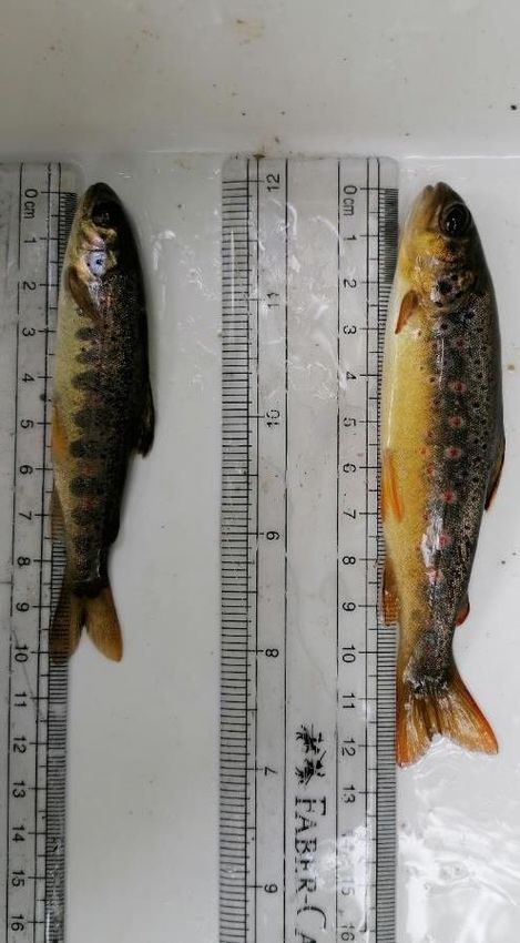
Castlebanny wind farm fisheries assessment 2020 11Plate 3.2 Example of brown trout recorded from site A3 on an unnamed stream at Cappagh, July 2020 3.1.4 Site A4 – Mullenhakill Stream, Cappagh Brown trout was the only fish species recorded at site A4 on the Mullenhakill Stream at site A4, located approx. 0.4km upstream of the Arrigle River confluence. A relatively high density of young-of-the-year brown trout were captured (4.0-6.3cm FL) but adults were absent (Figure 3.2). The small, shallow (0.15m max.) heavily overgrown site had been extensively straightened and deepened historically and evidently suffered from agriculturally-derived siltation pressures (i.e. livestock poaching). Siltation was moderate to heavy, locally. The substrata were comprised of compacted boulder, cobbles, medium and fine gravels in an upland eroding channel. Despite this, the site was evidently a good salmonid nursery (brown trout only), although spawning and holding habitat was moderate quality, at best. European eel habitat was moderate, at best, with the stream offering potential as a migratory pathway given its connectivity with the Arrigle River downstream. The site was of moderate spawning and poor nursery value to lamprey (none recorded present). Castlebanny wind farm fisheries assessment 2020 12
8

                  7

                  6

                  5
 Number of fish

                  4

                  3

                  2

                  1

                  0
                      0        2               4                 6           8              10
                                                Length class (cm)

                                                   Brown trout

Figure 3.3 Fish stock length distribution recorded via electro-fishing at site A4 on Mullenhakill
Stream, Cappagh in July 2020.

Plate 3.3 Example of juvenile brown trout recorded from site A4 on the Mullenhakill Stream,
July 2020

     Castlebanny wind farm fisheries assessment 2020                                                13
3.1.5 Site A5 – Arrigle River, Coolnahau
A total of four fish species were recorded via electro-fishing from site A5 on the Arrigle River at
Coolnahau, located within the River Barrow and River Nore SAC (site code: 002162) (Figure 3.4).
Brown trout (n=52) followed by Lampetra sp. ammocoetes (n=34) and Atlantic salmon (n=23)
dominated the site, with a single European eel also recorded.
The semi-natural river channel with a well-defined thalweg, (i.e. riffle, glide and pool sequences
with mature riparian zone) featured a riverbed comprised of small boulder and cobble with
coarse, medium and fine gravels. Beds of sand and silt were present in depositional meanders
and on the depositing margins of deeper glide and pool. There were evident issues with siltation
(moderate siltation) and partial compaction of gravels. However, the site was an excellent nursery
for salmonids, with good spawning and good holding habitat for adult fish. Beds of water crowfoot
(Ranunculus subgenus Batrachion sp.) in faster riffle areas provided excellent nursery for juvenile
salmonids. The site also offered very good spawning and nursery areas for lamprey (Lampetra
sp.). European eel habitat was good throughout given ample instream refugia such as larger
boulder and cobble in addition to large woody vegetation and macrophyte beds, although only a
single adult was captured.
15
14
13
12
11
10
Number of fish
9
8
7
6
5
4
3
2
1
0
0 2 4 6 8 10 12 14 16 18 20 22 24
Length class (cm)
Brown trout European eel Lampetra sp. Atlantic salmon
Figure 3.4 Fish stock length distribution recorded via electro-fishing at site A5 on the River
Arrigle, Coolnahau in July 2020.
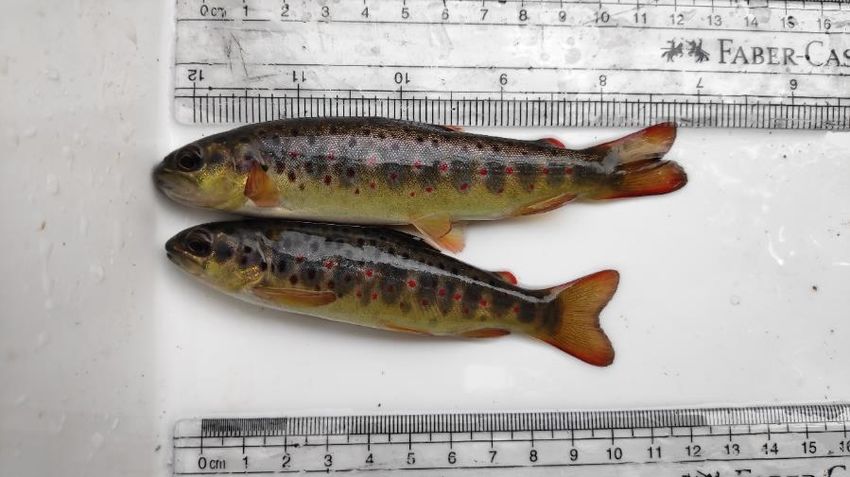
Castlebanny wind farm fisheries assessment 2020 14Plate 3.4 Example of Atlantic salmon parr (top) and adult brown trout recorded from site A5 on the Arrigle River, July 2020 3.1.6 Site A6 – Garrandarragh Stream, Garrandarragh Two fish species were recorded from the Garrandarragh Stream at site A6 (Figure 3.5), located on the boundary of the River Barrow and River Nore SAC (002162). Brown trout made up the majority of the catch (n=34), with the population dominated by juvenile fish (2.8-6.2cm FL). A small number of small adult trout were captured in addition to two European eel. Despite historical straightening and siltation pressures, the site was evidently a valuable brown trout nursery, with a high number of juveniles recorded. The site likely contributed significantly to the adjoining Arrigle River trout population (i.e. Arrigle nursery stream). Spawning habitat, although impacted, was of good quality locally. Whilst some localised finer gravel areas offered potential for lamprey spawning (Lampetra sp. only), larval habitat was poor given a high clay component to the limited soft sediment areas. European eel habitat was considered moderate, given the small, shallow nature of the stream but evidently offered good foraging potential for the species. Castlebanny wind farm fisheries assessment 2020 15
10

                  9

                  8

                  7
 Number of fish

                  6

                  5

                  4

                  3

                  2

                  1

                  0
                       0   2   4   6   8   10   12   14    16   18   20   22    24   26   28   30   32   34   36
                                                          Length class (cm)

                                                Brown trout      European eel

Figure 3.5 Fish stock length distribution recorded via electro-fishing at site A6 on the
Garrandarragh Stream, Garrandarragh in July 2020.

Plate 3.5 Example of young-of-the-year (0+) brown trout recorded from site A6 on the
Garrandarragh Stream, July 2020

     Castlebanny wind farm fisheries assessment 2020                                                               16
3.1.7 Site A7 – Garrandarragh Stream, Garrandarragh
Brown trout were the only fish species recorded from site A7 on the Garrandarragh Stream,
located approx. 0.8km upstream of site A6. Low numbers of juveniles were present with a single
small adult captured in a small pool in the the vicinity of the road culvert (Figure 3.6). The road
culvert featured a fall of c.0.5m and was considered a barrier to fish migration.
Site A7 offered moderate salmonid habitat only (Table 3.2) given its small, shallow nature.
Spawning and nursery habitat were considered moderate with poor holding habitat due to the
lack of deeper pools. European eel habitat was considered moderate, given the small, shallow
nature of the stream although some habitat suitability was present in the form of boulder and
large woody debris refugia in addition to undercut banks (none recorded, however). Whilst some
localised fine gravel areas offered moderate potential for lamprey spawning (Lampetra sp. only),
larval habitat was not present given the absence of soft sediment accumulations due to the
upland eroding nature of the site.
3
2
Number of fish
1
0
0 2 4 6 8 10
Length class (cm)
Brown trout
Figure 3.6 Fish stock length distribution recorded via electro-fishing at site A7 on the
Garrandarragh Stream, Garrandarragh in July 2020
Castlebanny wind farm fisheries assessment 2020 17Plate 3.6 Example of juvenile brown trout recorded from site A7 on the Garrandarragh Stream, July 2020 3.1.8 Site A8 – Arrigle River, Ballycorcoran Bridge A total of four fish species were recorded from the Arrigle River at site A8 (Figure 3.7), located within the River Barrow and River Nore SAC (002162). Lampetra sp. ammocoetes (n=44) and brown trout (n=36) predominated, with moderate densities of Atlantic salmon parr (n=20) also recorded. A single European eel was also captured. The semi-natural river channel with a well-defined thalweg (i.e. riffle, glide and pool sequences with mature riparian zone) supported a particularly high abundance of fish in the local context. The site was evidently a valuable (excellent quality) salmonid nursery, with a range of both brown trout and Atlantic salmon age classes present, particularly in association with beds of Ranunculus subgenus Batrachion sp. vegetation. Spawning and holding habitat were of very good quality (Table 3.2). The site was also valuable for lamprey (Plate 3.7), with some very good spawning habitat present (Table 3.3). Beds of sand and silt in depositional meanders and on depositing margins of deeper glide and pool offered some excellent lamprey larval habitat (e.g. 6x2m bed of sand/silt underneath the bridge structure). European eel habitat was considered good despite the capture of only a single individual. Castlebanny wind farm fisheries assessment 2020 18
12
                  11
                  10
                  9
                  8
 Number of fish

                  7
                  6
                  5
                  4
                  3
                  2
                  1
                  0
                       0   2       4         6       8       10     12     14     16     18      20   22
                                                           Length class (cm)

                               Brown trout       Atlantic salmon   European eel   Lampetra sp.

Figure 3.7 Fish stock length distribution recorded via electro-fishing at site A8 on the Arrigle
River, Ballycorcoran Bridge in July 2020.

Plate 3.7 Example of Lampetra sp. ammocoetes recorded from site A8 on the Arrigle River, July
2020

     Castlebanny wind farm fisheries assessment 2020                                                       19
3.1.9 Site B1 – Ballytarsna River, Ballytarsna
Three fish species were recorded from site B1 on the Ballytarsna River (Figure 3.8), with a
moderate abundance of brown trout (n=14) recorded. All trout were juveniles (≤7.4cm FL). Low
numbers of three-spined stickleback and juvenile European eel were also captured.
Overall, the river at site B1 was considered a good salmonid nursery and spawning area given the
presence of relatively clean, unbedded spawning substrata and well oxygenated riffle areas. The
channel was of moderate value to European eel given the generally shallow nature and lack of
instream refugia, although foraging potential was good. Despite some suitable spawning areas,
the site was considered of too high energy for larval lamprey, with no suitable ammocoete habitat
present.
4
3
Number of fish
2
1
0
0 2 4 6 8 10 12 14 16 18
Length class (cm)
Brown trout European eel Three-spined stickleback
Figure 3.8 Fish stock length distribution recorded via electro-fishing at site B1 on the Ballytarsna
River, Ballytarsna in July 2020
Castlebanny wind farm fisheries assessment 2020 20Plate 3.8 Example of European eel recorded from site B1 on the Ballytarsna River, July 2020 3.1.10 Site B2 – Crowbally Stream, Ballytarsna Brown trout accounted for the majority of the catch at site B2, with a single three-spined stickleback also recorded (Figure 3.9). There were no juvenile trout captured, with all fish representing adult size classes. This demographic suggested recruitment issues at the site. While the river retained some semi--natural characteristics in terms of riffle-glide sequences, heavy sedimentation and bedding of the substrata (livestock poaching) had greatly diminished the salmonid value of the site, resulting in moderate nursery and spawning habitat. However, some good holding habitat was present (upstream of the pipe culvert) (Table 3.2). Salmonid spawning success was considered likely to be low given siltation pressures, which may have explained the absence of juvenile salmonids during the survey. The site was considered too high energy for lamprey and none were recorded. Sediment deposits were not present. European eel habitat was moderate, at best, and none were recorded. Castlebanny wind farm fisheries assessment 2020 21
3

                  2
 Number of fish

                  1

                  0
                      0   2   4      6        8        10       12       14     16   18   20
                                                  Length class (cm)

                                    Brown trout      Three-spined stickleback

Figure 3.9 Fish stock length distribution recorded via electro-fishing at site B2 on the Crowbally
Stream, Ballytarsna in July 2020

Plate 3.9 Example of three-spined stickleback recorded from site B2 on the Crowbally Stream,
July 2020

     Castlebanny wind farm fisheries assessment 2020                                                 22
3.1.11 Site B3 – Ballytarsna River, Ballytarsna
A total of four fish species were recorded from site B3 on the Ballytarsna River, located approx.
1.8km downstream from site B1 (Figure 3.10). Fish abundance was relatively low; brown trout
were the most frequently recorded (n=8), with low numbers of stone loach (n=3) and Atlantic
salmon (n=3) also recorded. A single three-spined stickleback was also captured.
The site suffered from moderate to heavy sedimentation with surface sediment visible on
bedrock and boulder and featured very limited pockets of gravel. This reduced the quality of
salmonid habitat, which was, nonetheless, still good overall owing to the good quality nursery
habitat present (Table 3.2). Whilst some very localised lamprey spawning habitat was present,
the absence of sediment accumulations precluded the presence of ammocoetes in addition to
the moderate energy of the site.
3
2
Number of fish
1
0
0 2 4 6 8 10 12
Length class (cm)
Brown trout Atlantic salmon Stone loach Three-spined stickleback
Figure 3.10 Fish stock length distribution recorded via electro-fishing at site B3 on Ballytarsna
River, Ballytarsna in July 2020.
Castlebanny wind farm fisheries assessment 2020 23Plate 3.10 Stone loach recorded from site B3 on the Ballytarsna River, July 2020 3.1.12 Site B4 – River Blackwater (Kilmacow), Castlegannon Three-spined stickleback were the only fish species recorded from site B4 on the upper River Blackwater (Kilmacow). These were present in low densities (Figure 3.11). The narrow (1.5m wide), shallow (0.2m) river site, which adjoined both coniferous afforestation and agricultural grassland, suffered from sedimentation, with the majority of instream substrata bedded and covered with fine silt. Thus, the site was a poor-quality nursery and spawning area for salmonids and also poor offered holding habitat. The fisheries value was diminished due to heavy sedimentation and afforestation (i.e. no broadleaf buffer). The high-energy nature of the site precluded the presence of lamprey. European eel habitat was also poor. Castlebanny wind farm fisheries assessment 2020 24
3

                  2
 Number of fish

                  1

                  0
                      0        2               4                  6          8              10
                                                Length class (cm)

                                           Three-spined stickleback

Figure 3.11 Fish stock length distribution recorded via electro-fishing at site B4 on the River
Blackwater (Kilmacow), Castlegannon in July 2020.

3.1.13 Site C1 – Jerpoint Church Stream, Ballyconway Bridge

A total of four fish species were recorded from site C1 on the Jerpoint Church Stream (Figure
3.12), a tributary of the Little Arrigle River (EPA code: 15L01) flowing north of the wind farm
boundary. Brown trout were the most abundant species (n=25) with low numbers of Lampetra
sp. ammocoetes, Atlantic salmon and European eel also recorded. Both juvenile and small adult
trout were captured.

The stream at site C1 had evidence of historical deepening and the stream bed featured
compacted substrata with heavy siltation which reduced the overall value of the site, particularly
for salmonids. The glide and pool-dominated site offered moderate nursery habitat for salmonids,
with moderate spawning and holding (localised deeper pools only). Whilst spawning habitat for
lamprey was of moderate value only, the presence of deep, fine silt accumulations downstream
of the road bridge provided some locally good nursery areas. However, densities of ammocoetes
was low. The site offered moderate value for European eel, with low numbers present.

     Castlebanny wind farm fisheries assessment 2020                                                 25
5
4
Number of fish
3
2
1
0
0 2 4 6 8 10 12 14 16
Length class (cm)
Brown trout Atlantic salmon European eel Lampetra spp.
Figure 3.12 Fish stock length distribution recorded via electro-fishing at site C1 on the Jerpoint
Church Stream, Ballyconway Bridge in July 2020.
Plate 3.10 Brown trout and Atlantic salmon recorded from site C1 on the Jerpoint Church
Stream, July 2020
Castlebanny wind farm fisheries assessment 2020 26Table 3.1 Fish species densities per m2 recorded at sites in the vicinity of Castlebanny wind farm via electro-fishing in July 2020. Values in bold represent
the highest densities recorded for each species, respectively. *values for Lampetra sp. are presented in no. fish per 1m2 quadrat targeted for lamprey.
Fish density (number fish per m2)
Approx. area Three-spined
Site CPUE Brown trout Atlantic salmon Lampetra sp. European eel Stone loach
fished (m2) stickleback
A1 5-minute 50 0 0 0 0 0 0
A2 5-minute 45 0.200 0 0 0.022 0 0
A3 10-minute 150 0.200 0 0 0 0 0
A4 5-minute 45 0.511 0 0 0 0 0
A5 10-minute 300 0.177 0.077 11* 0.003 0 0
A6 5-minute 75 0.467 0 0 0.027 0 0
A7 5-minute 45 0.200 0 0 0 0 0
A8 10-minute 400 0.090 0.050 14.67* 0.003 0 0
B1 10-minute 125 0.104 0 0 0.016 0 0.032
B2 10-minute 180 0.081 0 0 0 0 0.006
B3 10-minute 200 0.040 0.015 0 0 0.015 0.010
B4 10-minute 75 0 0 0 0 0 0.067
C1 10-minute 100 0.250 0.020 5* 0.020 0 0
Castlebanny wind farm fisheries assessment 2020 273.2 Fisheries habitat
3.2.1 Salmonid habitat
Salmonid habitat ranged from poor to excellent value across the riverine survey sites, according
to Life Cycle Unit scores (Table 3.2). Only the two sites on the Arrigle River (i.e. A5 and A8)
provided excellent quality salmonid habitat. Sites A4 (Mullenhakill Stream), A6 (Garrandarragh
Stream), B1 & B3 (Ballytarsna River) and B2 (Crowbally Stream) offered good quality salmonid
habitat, typically due to the presence of good quality nursery habitat. Salmonid habitat scores at
sites A2 (Arrigle Trib 3 Stream), A3 (unnamed stream ay Cappagh), A7 (Garrandarragh Stream)
and C1 (Jerpoint Church Stream) were reduced to ‘moderate’, mainly due to their compromised
spawning and nursery habitat.
Table 3.2 Life Cycle Unit scores for sites surveyed in the vicinity of Castlebanny wind farm, July
2020.
Salmonid habitat Salmonids
Site no. Spawning Nursery Holding Total score
value recorded
A1 Poor 4 4 4 12 No
A2 Moderate 3 2 4 9 Yes
A3 Moderate 3 3 3 9 Yes
A4 Good 3 2 3 8 Yes
A5 Excellent 2 1 2 5 Yes
A6 Good 2 2 4 8 Yes
A7 Moderate 3 3 4 10 Yes
A8 Excellent 2 1 2 5 Yes
B1 Good 2 2 4 8 Yes
B2 Good 3 3 2 8 Yes
B3 Good 3 2 3 8 Yes
B4 Poor 4 4 4 12 No
C1 Moderate 3 3 3 9 Yes
Castlebanny wind farm fisheries assessment 2020 283.2.2 Lamprey habitat
Lamprey habitat ranged from moderate to good across the survey sites, according to LHQI scores
(Table 3.3). No sites achieved excellent scores. The best lamprey habitat was located at the two
sites on the Arrigle River (i.e. A5 and A8). Site A8, in particular, supported fine sediment
accumulations which offered excellent quality ammocoete habitat. Site C1 on the Jerpoint Church
Stream also offered good overall lamprey habitat. Sites A4 (Mullenhakill Stream), A6 & A7
(Garrandarragh Stream) and B1 & B3 (Ballytarsna River) provided moderate quality lamprey
habitat only, typically due to the absence of suitable ammocoete habitat. Due to the physical
unsuitability for lamprey, scores were not calculated for the upland eroding watercourses at sites
A1, A2, A3 or B2.
Table 3.3 Lamprey Habitat Quality Index (LHQI) scores for sites surveyed in the vicinity of
Castlebanny wind farm, July 2020.
Lamprey
Site no. Lamprey habitat value Spawning Nursery Total score
recorded
A1 n/a – site unsuitable for lamprey (upland eroding channel) No
A2 n/a – site unsuitable for lamprey (upland eroding channel) No
A3 n/a – site unsuitable for lamprey (upland eroding channel) No
A4 Moderate 3 4 7 No
A5 Good 2 2 4 Yes
A6 Moderate 2 4 6 No
A7 Moderate 3 4 7 No
A8 Good 2 1 3 Yes
B1 Moderate 2 4 6 No
B2 n/a – site unsuitable for lamprey (upland eroding channel) No
B3 Moderate 3 4 7 No
B4 n/a – site unsuitable for lamprey (upland eroding channel) No
C1 Good 2 3 5 Yes
3.2.3 European eel habitat
European eel were recorded from a total of six sites (i.e. A2, A5, A6, A8, B1, C1), with the species
present in low numbers at these sites (1-2 fish only). In general, sites on the larger watercourses
such as the Arrigle River (A5 & A8) provided the better quality eel habitat given the presence of
ample instream refugia such as larger boulder and cobble, in addition to large woody vegetation
and macrophyte beds. Smaller, shallower watercourses found to support eel, such as the
Ballytarsna River and Jerpoint Church Stream, were of evidently of value but featured less optimal
habitat and instream refugia.
Castlebanny wind farm fisheries assessment 2020 294. Discussion 4.1 Most valuable sites 4.1.1 Salmonids Brown trout were recorded from all but two survey sites (i.e. sites A2, A3, A4, A5, A6, A7, A8, B1, B2, B3 & C1). Trout density was highest at sites on the Mullenhakill Stream (A4) and lower Garrandarragh Stream (A6) (Table 3.1), owing to the high abundance of juveniles present. These sites were evidently important nurseries for the downstream-connecting Arrigle River. Only the two sites on the Arrigle River (i.e. A5 and A8) provided excellent quality salmonid habitat (according to Life Cycle Unit scores) and both supported Atlantic salmon parr. Atlantic salmon were also recorded present at sites B3 (Ballytarsna River, River Blackwater tributary) and C1 (Jerpoint Church Stream, Little Arrigle River tributary). As would be expected in catchments exposed to pressures including afforestation and agriculture, such as those in the vicinity of Castlebanny, survey sites on larger watercourses (like the Arrigle) typically offered better quality salmonid habitat and supported higher densities of salmonids. Biological water quality was of Q4 (good status) or higher (Q4-5) across the majority of survey sites (see accompanying EIAR report, aquatic ecology section), which largely explains the wide distribution of salmonids across the survey watercourses. The abundance of salmonids is more stable at better quality sites (≥Q4), with salmonid populations tending to oscillate due to fry abundance ‘pulses’ at moderate quality sites (i.e. Q3-4) (Kelly et al., 2007; Champ et al., 2009). The majority of the survey sites were located on minor watercourses, where higher-energy conditions prevailed. This resulted in sub-optimal spawning (silted and or compacted substrata), nursery (shallow, lack of macrophytes/refugia) and holding habitat (lack of deeper pool areas). Whilst most sites supported only small, residual brown trout populations, such watercourses are nevertheless important when considered in the context of the wider catchment. 4.1.2 Lamprey Lamprey ammocoetes were recorded from sites A5 and A8 on the Arrigle River and C1 on the Jerpoint Stream. All were Lampetra sp. Site A8 at Ballycorcoran Bridge provided the best quality lamprey habitat (Table 3.3), with good quality spawning substrata present in addition to sand and silt accumulations on meanders and underneath the bridge. Sea lamprey (Petromyzon marinus) are known from the Arrigle (Kurz & Costello, 1999; NPWS data) although no juveniles were recorded in targeted surveys undertaken in 2004 and 2008 (Gargan et al., 2011; SRFB, 2008), nor were any recorded during this survey. Despite the presence of some spawning substrata (finer gravel fractions) in some Arrigle tributaries (Mullenhakill and Garranadaragh Streams) as well as the Ballytarsna River, suitable ammocoete habitat was lacking due to the prevalence of higher-energy conditions (as outlined above). Naturally such sites do not encourage the deposition of fine, organic rich sediment Castlebanny wind farm fisheries assessment 2020 30
required by larval lamprey (Goodwin et al., 2008; Aronsuu & Virkkala, 2014). In light of this, sites
A1, A2, A3 or B2 were considered unsuitable for lamprey species.

4.1.3 European eel

On both a global and Irish scale, the European eel is listed as ‘critically endangered’ (Pike et al.,
2020; King et al., 2011). European eel were recorded from a total of six sites (i.e. A2, A5, A6, A8,
B1, C1), with the species present in low numbers at these sites (1-2 fish only). In general, sites on
the larger watercourses such as the Arrigle River (A5 & A8) provided better-quality eel habitat
given the presence of ample instream refugia such as larger boulder and cobble, in addition to
large woody vegetation and macrophyte beds. Such diurnal refugia are vital for eel populations
(Laffaille et al., 2003).

Smaller, shallower watercourses found to support eel, such as the Ballytarsna River and Jerpoint
Church Stream, were of evidently of value but featured less optimal habitat and instream refugia.
Such watercourses likely serve a more important function as eel migratory pathways than
foraging and nursery habitats. Furthermore, even small channels with poor or little overall
fisheries value offer value as potential European eel migratory pathways provided they maintain
downstream connectivity to larger watercourses and catchments (e.g. adult migration seawards,
usually from September/October onwards).

  Castlebanny wind farm fisheries assessment 2020                                                       31
5.     References

Amiro, P. G. (1993). Habitat measurement and population estimation of juvenile Atlantic salmon (Salmo
salar). Canadian Special Publication of Fisheries and Aquatic Sciences, 81-97.

APEM (2004). Assessment of sea lamprey distribution and abundance in the River Spey: Phase II. Scottish
Natural Heritage Commissioned Report No. 027 (ROAME No. F01AC608).

Applegate, V.C. (1950). Natural history of the sea lamprey, Petromyzon marinus in Michigan. Special
Scientific Report of the US Fish and Wildlife Service, 55, 1-237.

Aronsuu, K. & Virkkala, P. (2014). Substrate selection by subyearling European river lampreys (Lampetra
fluviatilis) and older larvae (Lampetra spp.). Ecology of Freshwater Fish, 23: 644–655.

CEN (2003). Water Quality - Sampling of Fish with Electricity. Document CEN EN 14011:2000.

CFB (2008). Methods for the Water Framework Directive. Electric Fishing in Wadeable Reaches. Central
Fisheries Board, Dublin. Unpublished report.

Champ, W., Kelly, F., & King, J. (2009). The Water Framework Directive: using fish as a management
tool. Biology and Environment (Dublin), 109(3), 191.

EA (2003). River Habitat Survey in Britain and Ireland: Field Survey Guidance Manual: 2003 Version. Forest
Research. Environment Agency, UK.

Gardiner, R. (2003). Identifying lamprey. A field key for sea, river and brook lamprey. Conserving Natura
2000 Rivers, Conservation techniques No. 4. Peterborough. English Nature.

Gargan, P. G., Roche, W. K., Keane, S., King, J. J., Cullagh, A., Mills, P., & O’Keeffe, J. (2011). Comparison of
field‐and GIS‐based assessments of barriers to Atlantic salmon migration: a case study in the Nore
Catchment, Republic of Ireland. Journal of Applied Ichthyology, 27, 66-72.

Goodwin, C.E., Dick, J.T.A. & Elwood, R.W. (2008). A preliminary assessment of the distribution of the sea
lamprey (Petromyzon marinus L), river lamprey (Lampetra fluviatilis (L.)) and brook lamprey (Lampetra
planeri (Bloch)) in Northern Ireland. Biology and Environment: Proceedings of the Royal Irish Academy
109B, 47-52.

Harvey, J. & Cowx, I. (2003). Monitoring the River, Sea and Brook Lamprey, Lampetra fluviatilis, L. planeri
and Petromyzon marinus. Conserving Natura 2000 Rivers Monitoring Series No. 5, English Nature,
Peterborough.

Kelly, F.L., Connor, L., Matson, R., Feeney, R., Morrissey, E., Coyne, J. and Rocks, K. (2015). Sampling Fish for
the Water Framework Directive, Rivers 2014. Inland Fisheries Ireland, 3044 Lake Drive, Citywest Business
Campus, Dublin 24, Ireland.

Kelly, F.L., Connor, L., Matson, R., Feeney, R., Morrissey, E., Coyne, J. and Rocks, K. (2010). Sampling Fish for
the Water Framework Directive, Rivers 2008. Central Fisheries Board, Dublin.

Kennedy, G.J.A. (1984). Evaluation of techniques for classifying habitats for juvenile salmon (Salmo salar L.)
Proceedings of the Atlantic Salmon trust workshop on stock enhancement. 23 pp.

  Castlebanny wind farm fisheries assessment 2020                                                                   32
King, J.L., Marnell, F., Kingston, N., Rosell, R., Boylan, P., Caffrey, J.M., FitzPatrick, Ú., Gargan, P.G., Kelly,
F.L., O’Grady, M.F., Poole, R., Roche, W.K. & Cassidy, D. (2011). Ireland Red List No. 5: Amphibians, Reptiles
& Freshwater Fish. National Parks and Wildlife Service, Department of Arts, Heritage and the Gaeltacht,
Dublin, Ireland.

Laffaille P., Feunteun E., Baisez A., Robinet T., Acou A., Legault A. & Lek S. (2003). Spatial organisation of
European eel (Anguilla anguilla L.) in a small catchment. Ecology of Freshwater Fish 12, 254–264

Macklin, R., Brazier, B. & Gallagher, C. (2018). Fisheries assessment of selected weir sites on the River
Barrow, Counties Carlow & Kilkenny. Unpublished report prepared by Triturus Environmental Services for
McCarthy-Keville O’ Sullivan on behalf of Waterways Ireland.

Maitland, P.S. (2003). Ecology of the River, Brook and Sea Lamprey. Conserving Natura 2000 Rivers Ecology
Series No. 5. English Nature, Peterborough.

Matson, R., Delanty, K., Shephard, S., Coghlan, B., & Kelly, F. (2018). Moving from multiple pass depletion
to single pass timed electrofishing for fish community assessment in wadeable streams. Fisheries Research,
198, 99-108.

McGinnity, P., Gargan, P., Roche, W., Mills, P. & McGarrigle, M. (2003). Quantification of the Freshwater
Salmon Habitat Asset in Ireland using data interpreted in a GIS platform. Irish Freshwater Fisheries, Ecology
and Management Series: Number 3, Central Fisheries Board, Dublin, Ireland.

Niven, A.J. & McCauley, M. (2013). Lamprey Baseline Survey No2: River Faughan and Tributaries SAC.
Loughs Agency, 22, Victoria Road, Derry.

O’Connor, L. & Kennedy, R.J (2002). A comparison of catchment-based salmon habitat survey techniques
on three rivers in N. Ireland. Fisheries Management and Ecology, 9, 149-161.

O’Connor, W. (2007) A Survey of Juvenile Lamprey Populations in the Corrib and Suir Catchments. Irish
Wildlife Manuals No. 26. National Parks and Wildlife Service, Department of Environment, Heritage and
Local Government, Dublin, Ireland.

O'Grady, M.F. (2006). Channels and challenges: enhancing Salmonid rivers. Irish Fresh- water Fisheries
Ecology and Management Series: Number 4. Central Fisheries Board, Dublin.

Pike, C., Crook, V. & Gollock, M. (2020). Anguilla anguilla. The IUCN Red List of Threatened Species 2020:
e.T60344A152845178. https://dx.doi.org/10.2305/IUCN.UK.20202.RLTS.T60344A152845178.en

Potter, I. C., & Osborne, T.S. (1975). The systematics of British larval lampreys. Journal of Zoology, 176(3),
311-329.

Slade, J. W., Adams, J. V., Christie, G. C., Cuddy, D. W., Fodale, M. F., Heinrich, J. W. & Young, R. J. (2003).
Techniques and methods for estimating abundance of larval and metamorphosed sea lampreys in Great
Lakes tributaries, 1995 to 2001. Journal of Great Lakes Research, 29, 137-151.

SRFB (2008). Assessment of the Risk of Barriers to Fish Migration in the Nore Catchment. Report prepared
by the Central Fisheries Board, Southern Regional Fisheries Board and Compass Informatics, December
2008.

Sullivan, A. (2007). Assessment of Fish Passage and the Ecological Impact of Migration Barriers on the River
Nore Catchment. Report prepared for the Nore Suir Rivers Trust.

  Castlebanny wind farm fisheries assessment 2020                                                                     33
Triturus Environmental Ltd.

                                    42 Norwood Court,

                                        Rochestown,

                                           Co. Cork

Castlebanny wind farm fisheries assessment 2020               34
You can also read