FARMLAND, DEVELOPMENT, URBAN SERVICE AND OTHER LAND - edmonton.ca/assessment A summary of the methods used by the City of Edmonton in determining ...
←
→
Page content transcription
If your browser does not render page correctly, please read the page content below

2021
ASSESSMENT
METHODOLOGY
FARMLAND, DEVELOPMENT,
URBAN SERVICE AND OTHER LAND

A summary of the methods used by the City of Edmonton in
determining the value of agricultural, development and dual use
land properties in Edmonton for assessment purposes.

edmonton.ca/assessment
2021 Farm Land, Development, Urban Service, and Other Land
Assessment Methodology Page | 1
Table of Contents
Scope 2
Introduction 2
Mass Appraisal 4
Valuation Models 6
Approaches to Value 7
Direct Comparison Approach 7
Classification 8
Land Use Codes (LUCs) 8
Property Groups 9
Farm Land 9
Definition of ‘farming operation’ 9
Agricultural Use Value 10
Market Value Farm Land 11
Development Land 13
Urban Service and Other Land 15
Zoning 16
Agricultural Use Zoning 17
Farm Buildings 18
Order In Council 359/2018 18
Definitions 20
Other Adjustments 20
Sample Assessment Detail Report 21
Methods to Adjust Comparables 22
Quantitative Adjustments 22
Qualitative Analysis 23
References 24
Appendix 25
Map 25
Zone Charts for Farm Land, Development, Urban Service and Other Land 26
Measure Conversion Chart 32
Copyright of this material and content is owned by the City of Edmonton and none of the content and material may be
copied, reproduced, posted or transmitted in any form without the prior written consent of the City of Edmonton, unless
otherwise being used in accordance with Section 299 and 300 of the Municipal Government Act, R
SA 2000, c M-26.
2021 Farm Land, Development, Urban Service, and Other Land
Assessment Methodology Page | 2
Scope
This guide is an aid in explaining how Farm Land, Development, Urban Service, and Other Land
properties are valued for assessment purposes. The guide is intended as a tool and complements
the assessor’s judgment in the valuation process.
Introduction
Property assessments in the City of Edmonton are prepared in accordance with the requirements of
the Municipal Government Act, R.S.A. 2000, c. M-26, (hereinafter “MGA” ) and the Matters Relating to
Assessment and Taxation Regulation, 2018, Alta Reg 203/17, (hereinafter “MRAT”). The MRAT regulation
establishes the valuation standard to be used, defines the procedures to be applied, and proposes
objectives for the quality to be achieved in the preparation of assessments. The legislation requires
the municipality to prepare assessments that represent market value by application of the mass
appraisal process. All assessments are expected to meet quality standards prescribed by the
province in the MRAT regulation.
Property assessments represent:
● an estimate of the value;
● of the fee simple estate in the property;
● as the property existed on December 31, 2020;
● reflecting typical market conditions;
● as if the property had been sold on July 1, 2020;
● on the open market;
● from a willing seller to a willing buyer.
The assessment is a prediction of the value that would result when those specific, defined conditions
are met.
The legislation requires the City of Edmonton to assess the fee simple estate.
“Fee simple interest [is] absolute ownership unencumbered by any other interest or estate…
leased fee interest [is] the ownership interest held by the lessor, which includes the right to
the contract rent specified in the lease plus the reversionary right when the lease expires…
leasehold interest [is] the interest held by the lessee (the tenant or renter) through a lease
conveying the rights of use and occupancy for a stated term under certain conditions.”
Appraisal Institute of Canada, T
he Appraisal of Real Estate Third Canadian Edition,
Vancouver, Canada, 2010, page 6.4
Copyright of this material and content is owned by the City of Edmonton and none of the content and material may be
copied, reproduced, posted or transmitted in any form without the prior written consent of the City of Edmonton, unless
otherwise being used in accordance with Section 299 and 300 of the Municipal Government Act, R
SA 2000, c M-26.2021 Farm Land, Development, Urban Service, and Other Land
Assessment Methodology Page | 3
Both market value and property a
long with additional terms are defined in the M
GA and M
RAT :
s.284(1)(r) “property” means
(i) a parcel of land
(ii) an improvement, or
(iii) a parcel of land and the improvements to it
MGA .s.284(1)(r)
s.1(k) “regulated property” means
(i) land in respect of which the valuation standard is agricultural use value,
(ii) designated industrial property, or
(iii) machinery and equipment
MRAT s.1(k)
s.9(1) t he valuation standard f or the land and improvements is market value unless
subsection (2)… applies
MRAT s.9(1)
s.1(1)(n) “market value” means the amount that a property, as defined in section 284(1)(r),
might be expected to realize if it is sold on the open market by a willing seller to a willing
buyer
MGA s.1(1)(n)
s.5 An assessment of property based on m arket value
(a) must be prepared using mass appraisal,
(b) must be an estimate of the value of the fee simple estate in the property, and
(c) must reflect typical market conditions for properties similar to that property
MRAT s.5
s.289(2) Each assessment must reflect
(a) the characteristics and physical condition of the property on December 31 of the
year prior to the year in which a tax is imposed
MGA s.289(2)(a)
s.6 Any assessment prepared in accordance with the Act must be an estimate of the value of
a property on J uly 1 of the assessment year
MRAT s.6
s.1(g) “mass appraisal” means the process of preparing assessments for a group of
properties using standard methods and common data and allowing for statistical testing
MRAT s.1(g)
Copyright of this material and content is owned by the City of Edmonton and none of the content and material may be
copied, reproduced, posted or transmitted in any form without the prior written consent of the City of Edmonton, unless
otherwise being used in accordance with Section 299 and 300 of the Municipal Government Act, R
SA 2000, c M-26.2021 Farm Land, Development, Urban Service, and Other Land
Assessment Methodology Page | 4
Mass Appraisal
Mass appraisal is the legislated methodology used by the City of Edmonton for valuing individual
properties, and involves the following process:
● properties are stratified into groups of comparable property
● common property characteristics are identified for the properties in each group
● a uniform valuation model is created for each property group
31(c) “valuation model” means the representation of the relationship between property
characteristics and their value in the real estate marketplace using a mass appraisal
process
MRAT s.31(c)
The following two quotations indicate how the International Association of Assessing Officers
distinguishes between mass appraisal and single-property appraisal:
“... single-property appraisal is the valuation of a particular property as of a given date: mass
appraisal is the valuation of many properties as of a given date, using standard procedures
and statistical testing.”
“Also, mass appraisal requires standardized procedures across many properties. Thus,
valuation models developed for mass appraisal purposes must represent supple and
demand patterns for groups of properties rather than a single property.”
Property Appraisal and Assessment Administration, pg. 88-89
Copyright of this material and content is owned by the City of Edmonton and none of the content and material may be
copied, reproduced, posted or transmitted in any form without the prior written consent of the City of Edmonton, unless
otherwise being used in accordance with Section 299 and 300 of the Municipal Government Act, R
SA 2000, c M-26.2021 Farm Land, Development, Urban Service, and Other Land
Assessment Methodology Page | 5
For both mass appraisal and single-property appraisal, the process consists of the following stages:
Mass Appraisal Single Appraisal
Mass appraisal is used to The client specifies the nature of
determine the assessment the value to be estimated,
Definition and
base for property taxation including rights to be valued,
Purpose in accordance with effective date of valuation, and
legislative requirements any limiting conditions
Mass appraisal requires a The extent of data collection is
continuing program to specific to each assignment and
maintain a current depends on the nature of the
Data Collection database of property client’s requirements
characteristics and market
information
Mass appraisal is Market analysis includes the
Market Analysis predicated on highest and analysis of highest and best use
best use
Valuation procedures are Subject property is the focus of
predicated on groups of the valuation. The analysis of
Valuation Model comparable properties comparable properties is
generally six or less
The testing of acceptable The reliability of the value
analysis and objective estimate is more subjective.
Validation
criteria Acceptability can be judged by
the depth of research and
analysis of comparable sales
Copyright of this material and content is owned by the City of Edmonton and none of the content and material may be
copied, reproduced, posted or transmitted in any form without the prior written consent of the City of Edmonton, unless
otherwise being used in accordance with Section 299 and 300 of the Municipal Government Act, R
SA 2000, c M-26.2021 Farm Land, Development, Urban Service, and Other Land
Assessment Methodology Page | 6
Valuation Models
A valuation model creates an equation of variables, factors and coefficients that explains the
relationship between estimated market value and property characteristics. An assessed value is
then calculated by applying the appropriate valuation model to individual properties within a
property type.
s31 (a) “coefficient” means a number that represents the quantified relationship of each
variable to the assessed value of a property when derived through a mass appraisal
process
(b) “ factor” means a property characteristic that contributes to a value of a property;
(d) “ variable” means a quantitative or qualitative representation of a property
characteristic used in a valuation model
MRAT, s.31 (a), (b) and (d)
s.33 Information prescribed… does not include coefficients
MRAT, s.33(3)
● variables are created from property characteristics
● analysis of how variables affect market value
Valuation ● factors and coefficients are determined
Model ● the resulting valuation models are applied to property
characteristics
Depending on the property type multiple regression analysis or other mass appraisal techniques are
used to determine variables, factors and coefficients.
“Multiple Regression Analysis (MRA): a statistical technique used to analyze data to predict
market value (dependant variable) from known values of property characteristics
(independent variables)”
Property Appraisal and Assessment Administration, pg. 653
Copyright of this material and content is owned by the City of Edmonton and none of the content and material may be
copied, reproduced, posted or transmitted in any form without the prior written consent of the City of Edmonton, unless
otherwise being used in accordance with Section 299 and 300 of the Municipal Government Act, R
SA 2000, c M-26.2021 Farm Land, Development, Urban Service, and Other Land
Assessment Methodology Page | 7
Approaches to Value
The approaches to determine market value are the direct comparison, income, and cost approaches.
Direct Typical market value (or some other characteristic) is determined by
referencing comparable sales and other market data. It is often used
Comparison
when sufficient sales or market data is available. It may also be referred
Approach to as the Sales Comparison Approach.
This approach considers the typical actions of renters, buyers and sellers
when purchasing income-producing properties. This approach estimates
Income
the typical market value of a property by determining the present value
Approach of the projected income stream. Often used to value rental or leased
property.
Typical market value is calculated by adding the depreciated replacement
Cost cost of the improvements to the estimated value of land. It is often used
Approach for properties under construction or when there is limited market data
available.
Certain regulated properties are not valued using the above approaches to value.
Direct Comparison Approach
The direct comparison approach is the most appropriate method of valuation for the market value
portions of Farm Land, Development, Urban Service, and Other Land properties in the City of
Edmonton because it mirrors the actions of buyers and sellers in the marketplace and sufficient
sales data exists in order to derive reliable market estimates.
The City of Edmonton validates all land title transactions (sales). The validation process can include
site inspections, interviews with parties involved, a review of land title documents, corporate
searches, third party information, and sale validation questionnaires. Sales analysis for the market
value portions of Farm Land, Development, Urban Service, and Other Land also includes a review for
future zoning changes, current and proposed area structure plans, availability of services and/or
cost of providing services, and development applications.
The City of Edmonton has reviewed sales occurring from July 1, 2013 to June 30, 2020 for the market
value portions of Farm Land, Development, Urban Service, and Other Land property. The City of
Edmonton uses the date the legal title transfer was registered at the Land Titles Office as the sale
date of a property.
Sale price reflects the condition of a property on the sale date and may not be equal to the
assessment.
Copyright of this material and content is owned by the City of Edmonton and none of the content and material may be
copied, reproduced, posted or transmitted in any form without the prior written consent of the City of Edmonton, unless
otherwise being used in accordance with Section 299 and 300 of the Municipal Government Act, R
SA 2000, c M-26.2021 Farm Land, Development, Urban Service, and Other Land
Assessment Methodology Page | 8
The cost approach to value was applied to improvements on the on Farm Land, Development, Urban
Service, and Other Land properties. For single family residential improvements please see the 2021
Assessment Methodology - Residential Cost guide (www.edmonton.ca). All other buildings were
valued using the Marshall and Swift Costing Manual.
The income approach was not used in the valuation of these properties since that approach is more
applicable to purpose built income producing improved properties.
Classification
As per MGA Section 297(1): When preparing an assessment of property, the assessor must assign
one or more of the following assessment classes to the property:
(a) class 1 - residential;
(b) class 2 - non-residential;
(c) class 3 - farm land;
(d) class 4 - machinery and equipment.
Assigning assessment classes requires a consideration of the class definitions and related sections
found within MGA section 297, the MRAT regulation, City of Edmonton Charter, Edmonton Zoning
Bylaw, No. 12800, and possibly the Municipal Development Plan, Area Structure Plans, and Overlays.
Any legislation that affects how a property can be used may affect its classification.
The Municipal Development Plan, Area Structure Plans, and Overlays can be found on the City
website, www.edmonton.ca, under
“City Government > U
rban Planning & Design > Planning > P
lans in Effect” o
r
“City Government > B ylaws > Zoning B
ylaw”
Land Use Codes (LUCs)
Land use (LUC) is an internal set of codes used to describe the current use or uses of a property. A
parcel may have one or more LUC based upon a property’s use. The LUC helps the assessor to
identify a property’s class or subclass, and indicate which corresponding tax (mill) rate should be
applied. The following list contains frequently used codes within the Farm Land, Development,
Urban Service and Other Land inventory of properties; it is not a complete list of all Land uses
applied by The City of Edmonton.
LUC Description Assessment Class
853 Farm land Farm Land
855 Rural land adjacent to water and sewer Farm Land
258 Fenced storage Non-Residential
272 Commercial greenhouse Non-Residential
557 Road right of way Non-Residential
748 Undeveloped park Non-Residential
758 Natural preserve Non-Residential
760 Storm water pond Non-Residential
Copyright of this material and content is owned by the City of Edmonton and none of the content and material may be
copied, reproduced, posted or transmitted in any form without the prior written consent of the City of Edmonton, unless
otherwise being used in accordance with Section 299 and 300 of the Municipal Government Act, R
SA 2000, c M-26.2021 Farm Land, Development, Urban Service, and Other Land
Assessment Methodology Page | 9
822 Acreage for non-residential use (building and land) Non-Residential
900 Undeveloped non-residential land Non-Residential
902 Remnant or utility lot for non-residential use Non-Residential
907 Non-residential bare land condominium (land only) Non-Residential
922 Remnant or utility lot for non-residential use Non-Residential
800 Acreage for residential use (building and land) Residential
805 Vacant/unimproved rural land Residential
832 Farm-use buildings and structures Residential
835 Residential development land Residential
901 Utility lot for residential use Residential
950 Leased City-owned residential land Residential
8531 First farm residence (Edmonton South Special Area only) Residential
8532 Additional farm residence (Edmonton South Special Area only) Residential
Property Groups
Generally, the use of a property determines the property groupings and the valuation model
applied.
use: the purpose or activities for which a piece of land or its buildings are designed,
arranged, developed or intended, or for which it is occupied or maintained..
Zoning Bylaw No. 12800, 207, s. 6.117
Farm Land
In the context of property assessment, Farm Land is not a loosely used term to describe land that is
merely suitable for farming. It is land legally allowed and used for agricultural purposes and meets
the regulatory definitions of a farming operation on an annual basis. The science of Agriculture
practiced by many Albertans sees cultivation and effort placed into making a harvestable and
saleable crop in the context of a bona fide farming operation whose business is the production of
products in a real, ongoing business.
Definition of ‘farming operation’
Farming operations is defined in Section 2(1)(f) of the M
RAT Regulation
2(1)(f) “farming operations” means the raising, production and sale of agricultural products
and includes
(i) horticulture, aviculture, apiculture and aquaculture,
(ii) the raising, production and sale of
(A) horses, cattle, bison, sheep, swine, goats or other livestock,
(B) fur-bearing animals raised in captivity,
Copyright of this material and content is owned by the City of Edmonton and none of the content and material may be
copied, reproduced, posted or transmitted in any form without the prior written consent of the City of Edmonton, unless
otherwise being used in accordance with Section 299 and 300 of the Municipal Government Act, R
SA 2000, c M-26.2021 Farm Land, Development, Urban Service, and Other Land
Assessment Methodology Page | 10
(C) domestic cervids within the meaning of the Domestic Cervid Industry
Regulation (AR 188/2014), or
(D) domestic camelids,
(iii) the planting, growing and sale of sod, and
(iv) an operation on a parcel of land for which a woodland management plan has been
approved by the Woodlot Association of Alberta or a forester registered under
Regulated Forestry Profession Act Section 6 for the production of timber primarily
marketed as whole logs, seed cones or Christmas trees,
but does not include any operation or activity on land that has been stripped for the
purposes of, or in a manner that leaves the land more suitable for, future development;
Farm Land rates
Rates Description
FARM Farm Land
Farmland (FARM): Farm Land is land that is used for farming operations and assessed at
agricultural use value
Agricultural Use Value
The valuation standard for land used as part of a farming operation is, with the exceptions set out in
Section 7(3) of the MRAT regulation, agricultural use value. Land assessed at agricultural use value is
regulated property.
Municipal Affairs’ Guide to Assessment and Taxation in Alberta indicates that Farm Land is assessed on
the basis on its productive value; that is, the ability of the land to produce income from the growing
of crops and/or the raising of livestock.1 In other words, the lower valuation standard for Farm Land
assessment is a way to reduce a producers cost of production when the land is used for traditional
agricultural practices. 1 Guide to Property Assessment and Taxation in Alberta, Municipal Affairs, January 2018, p. 8
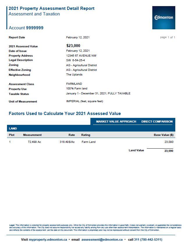
For 2021, Farm Land has been assessed at the rate of $787 per Hectare or $318.49 per acre. Farm
Land located in special area Edmonton South (certain lands annexed to the City of Edmonton in
2019) may have different rates applied as per Order In Council 359/2018.
Copyright of this material and content is owned by the City of Edmonton and none of the content and material may be
copied, reproduced, posted or transmitted in any form without the prior written consent of the City of Edmonton, unless
otherwise being used in accordance with Section 299 and 300 of the Municipal Government Act, R
SA 2000, c M-26.2021 Farm Land, Development, Urban Service, and Other Land
Assessment Methodology Page | 11
Market Value Farm Land
Section 7(3) of the MRAT regulation requires that certain land be assessed at market value,
notwithstanding that it is used for farming operations. Land used for farming operations that is
assessed at market value includes:
• a parcel of land containing less than one acre;
• a parcel of land containing at least one acre but not more than 3 acres that is used but not
necessarily occupied for residential purposes or can be serviced by using water and sewer
distribution lines located in land that is adjacent to the parcel;
• an area of 3 acres located within a larger parcel of land where any part of the larger parcel
is used but not necessarily occupied for residential purposes;
• an area of 3 acres that is located within a parcel of land, and can be serviced by using water
and sewer distribution lines located in land that is adjacent to the parcel;
• any area that is located within a parcel of land, is used for commercial or industrial
purposes, and cannot be serviced by using water and sewer distribution lines located in land
that is adjacent to the parcel;
• an area of 3 acres or more that is located within a parcel of land, is used for commercial or
industrial purposes, and can be serviced by using water and sewer distribution lines located
in land that is adjacent to the parcel.
Pursuant to s. 2(1)(f) of MRAT, any land that is “stripped for the purposes of, or in a manner that
leaves the land more suitable for, future development” does not qualify as a “farming operation”, is
not Farm Land, and is assessed at market value.
In accordance with previous decisions of the Assessment Review Board, land on which agricultural
activity occurs might not be assessed at the Farm Land rate in situations where:
• the agricultural use is unlawful pursuant to zoning restrictions and the absence of
development approval, and the landowner has no valid claim to a legal non-conforming use;
or
• the farming or agricultural activity is not a bona fide farming operation, but occurs solely or
primarily to obtain a tax benefit.
In these circumstances, the land will be assessed at market value.
Copyright of this material and content is owned by the City of Edmonton and none of the content and material may be
copied, reproduced, posted or transmitted in any form without the prior written consent of the City of Edmonton, unless
otherwise being used in accordance with Section 299 and 300 of the Municipal Government Act, R
SA 2000, c M-26.2021 Farm Land, Development, Urban Service, and Other Land
Assessment Methodology Page | 12
Market Value Rates - Land Used for Residential Purposes
Rates Description Rates Description
16 1st acre 21 Premium Location 3rd acre
17 2nd acre 22 Urban Influence 1st acre
18 3rd acre 23 Urban Influence 2nd acre
19 Premium Location 1st acre 24 Urban Influence 3rd acre
20 Premium Location 2nd acre
Rural Res 1st Acre (16): Rural Res 1st Acre refers to the first acre of a 3 acre site that is used but not
necessarily occupied for residential purposes and is not part of a rural residential neighbourhood.
Rural Res 2nd Acre (17): Rural Res 2nd Acre refers to the second acre of a 3 acre site that is used
but not necessarily occupied for residential purposes and is not part of a rural residential
neighbourhood.
Rural Res 3rd Acre (18): Rural Res 3rd Acre refers to the third acre of a 3 acre site that is used but
not necessarily occupied for residential purposes and is not part of a rural residential
neighbourhood.
Rural Res Acreage 1st Acre Premium Location (19): Rural Res Acreage 1st Acre Premium Location
refers to the first acre of a 3 acre site that is used but not necessarily occupied for residential
purposes, is not part of a rural residential neighbourhood, and is considered a Premium Location.
Premium Location refers to properties that abut or are across the road from a green space, natural
reserve, lake, pond, ravine, river, or golf course.
Rural Res Acreage 2nd Acre Premium Location (20): Rural Res Acreage 2nd Acre Premium
Location refers to the second acre of a 3 acre site that is used but not necessarily occupied for
residential purposes, is not part of a subdivision, and is considered a Premium Location. Premium
Location refers to properties that abut or are across the road from a green space, natural reserve,
lake, pond, ravine, river or golf course.
Rural Res Acreage 3rd Acre Premium Location (21): Rural Res Acreage 3rd Acre Premium Location
refers to the third acre of a 3 acre site that is used but not necessarily occupied for residential
purposes, is not part of a rural residential neighbourhood, and is considered a Premium Location.
Premium Location refers to properties that abut or are across the road from a green space, natural
reserve, lake, pond, ravine, river or golf course.
Rural Res Proximity to Urban Influence 1st Acre (22): Rural Res Proximity to Urban Influence 1st
Acre refers to the first acre of a 3 acre site on that is used but not necessarily occupied for
residential purposes and is within a mile proximity to development as defined in section 616(b) of
the MGA, or can be serviced by using water and sewer distribution lines located in land that is
adjacent to the parcel.
Copyright of this material and content is owned by the City of Edmonton and none of the content and material may be
copied, reproduced, posted or transmitted in any form without the prior written consent of the City of Edmonton, unless
otherwise being used in accordance with Section 299 and 300 of the Municipal Government Act, R
SA 2000, c M-26.2021 Farm Land, Development, Urban Service, and Other Land
Assessment Methodology Page | 13
Rural Res Proximity to Urban Influence 2nd Acre (23): Rural Res Proximity to Urban Influence 2nd
Acre refers to the second acre of a 3 acre site that is used but not necessarily occupied for
residential purposes and is within a mile proximity to development as defined in section 616(b) of
the MGA, or can be serviced by using water and sewer distribution lines located in land that is
adjacent to the parcel.
Rural Res Proximity to Urban Influence 3rd Acre (24): Rural Res Proximity to Urban Influence 3rd
Acre refers to the third acre of a 3 acre site that is used but not necessarily occupied for residential
purposes and is within a mile proximity to development as defined in section 616(b) of the MGA, or
can be serviced by using water and sewer distribution lines located in land that is adjacent to the
parcel.
Development Land
Development Land is land that is undergoing, or is anticipated to undergo, development activity.
This may relate to all or part of the property. Pursuant to s. 616(b) of the Municipal Government Act,
development means:
(i) an excavation or stockpile and the creation of either of them,
(ii) a building or an addition to or replacement or repair of a building and the construction or
placing of any of them on, in, over or under land,
(iii) a change of use of land or a building or an act done in relation to land or a building that
results in or is likely to result in a change in the use of the land or building, or
(iv) a change in the intensity of use of land or a building or an act done in relation to land or
a building that results in or is likely to result in a change in the intensity of use of the land or
building
The estimation of how close a parcel is to development is based upon what steps have been taken in
the development process as of December 31 of the prior year. Area Structure Plans, proximity to
servicing, development applications and zoning, prior subdivisions, and inspections all help to
determine which phase of development the parcel is in.
Development rates may have different market values depending on the region of the City in which
the property is located. Refer to the map, Market Areas for Agricultural and Development Land,
to view the market areas.
To reflect diminishing returns, development land is assessed at a lower rate every ten hectares. For
fairness and equity, the actual time to develop as planned by the property owner or developer is not
taken into consideration.
Copyright of this material and content is owned by the City of Edmonton and none of the content and material may be
copied, reproduced, posted or transmitted in any form without the prior written consent of the City of Edmonton, unless
otherwise being used in accordance with Section 299 and 300 of the Municipal Government Act, R
SA 2000, c M-26.2021 Farm Land, Development, Urban Service, and Other Land
Assessment Methodology Page | 14
Development Land Rates
Rates Description Rates Description Rates Description
1 Development 6 Premium 25 Non Residential
Development Premium Non Residential
3 8 27
2 to 3 years 2 to 3 years 2 to 3 years
Development Premium Non Residential
4 9 28
4 to 5 years 4 to 5 years 4 to 5 years
Development Premium Non Residential
5 10 29
> 5 years > 5 years > 5 years
Development Land (1): Development Land is Residential Development Land that is ready to be
developed and is typically forecasted to be subdivided into smaller parcels within a year.
Development Land Phase 2 to 3 years (3): Development Land Phase 2 to 3 years is Residential
Development Land that is ready to be developed and is typically forecasted to be subdivided into
smaller parcels within 2 to 3 years.
Development Land Phase 4 to 5 years (4): Development Land Phase 4 to 5 years is Residential
Development Land that is ready to be developed and is typically forecasted to be subdivided into
smaller parcels within 4 to 5 years.
Development Land Phase More Than 5 years (5): Development Land Phase More Than 5 years is
Residential Development Land that is ready to be developed and is typically forecasted to be
subdivided into smaller parcels in more than 5 years.
Development Land with Premium Location (6): Development Land with Premium Location is
Residential Land that is ready to be developed and is typically forecasted to be subdivided into
smaller parcels within a year. Premium Location refers to properties that abut or are across the road
from green space, natural reserve, lake, pond, ravine, river or golf course.
Development Land with Premium Location Phase 2 to 3 years (8): Development Land with
Premium Location Phase 2 to 3 years is Residential Development Land that is ready to be developed
and is typically forecasted to be subdivided into smaller parcels within 2 to 3 years. Premium
Location refers to properties that abut or are across the road from green space, natural reserve,
lake, pond, ravine, river or golf course.
Development Land with Premium Location Phase 4 to 5 years (9): Development Land with
Premium Location Phase 4 to 5 years refers to Residential Development Land that is ready to be
developed and is typically forecasted to be subdivided into smaller parcels within 4 to 5 years.
Premium Location refers to properties that abut or are across the road from green space, natural
reserve, lake, pond, ravine, river or golf course.
Development Land with Premium Location Phase Plus 5 years (10): Development Land with
Premium Location Phase More Than 5 years refers to Residential Development Land that is ready to
Copyright of this material and content is owned by the City of Edmonton and none of the content and material may be
copied, reproduced, posted or transmitted in any form without the prior written consent of the City of Edmonton, unless
otherwise being used in accordance with Section 299 and 300 of the Municipal Government Act, R
SA 2000, c M-26.2021 Farm Land, Development, Urban Service, and Other Land
Assessment Methodology Page | 15
be developed and is typically forecasted to be subdivided into smaller parcels in more than 5 years.
Premium Location refers to properties that abut or are across from green space, natural reserve,
lake, pond, ravine, river or golf course.
Non-Residential Development Market (25): Non-Residential Development Market refers to
Non-Residential Development Land that is typically forecasted to be subdivided into smaller parcels
within a year.
Non-Residential Development Phase 2 to 3 years (27): Non-Residential Development Phase 2 to 3
years refers to Non-Residential Development Land that is typically forecasted to be subdivided into
smaller parcels within two to three years.
Non-Residential Development Phase 4 to 5 years (28): Non-Residential Development Phase 4 to 5
years refers to Non-Residential Development Land that is typically forecasted to be subdivided into
smaller parcels within 4 to 5 years.
Non-Residential Development Phase Plus 5 years (29): Non-Residential Development Phase Plus
5 years refers to Non-Residential Development Land that is typically forecasted to be subdivided into
smaller parcels within 5 years or more.
Urban Service and Other Land
Assessment of Public Utility, Urban Service and Park Land
Rates Description Rates Description
AP AP, A (Park Land) US Urban Service Lot (excess)
NP Natural Preserve US Excess Urban Service Lot 1st 2 Hectares
PU Public Utility Lot
US
Urban Service Lot (Unserviced)
Unserviced
30 Raw Land
A, AP Park Land (AP): Park Land refers to all or part of a property that is zoned or permitted to be
used as Metropolitan Recreation Zone or Public Parks Zone as per City Zoning Bylaw 12800. If the
current permitted use is different from the actual zoning of A/AP, then the appropriate market value
rate would apply.
Natural Preserve Land (NP): Natural Preserve Land refers to areas with uses severely limited by
topography and legal permissibility. This rate is primarily used in the assessment of NA and A zoned
land and properties located adjacent to the North Saskatchewan River, which are frequently limited
by the slope of the embankment.
Public Utility Lot (PU): A Public Utility Lot refers to all or part of a property that is zoned or
permitted to be used as Public Utility Zone as per City Zoning Bylaw 12800. A Public Utility Lot also
refers to a property that provides or is intended to provide a system or works for public
Copyright of this material and content is owned by the City of Edmonton and none of the content and material may be
copied, reproduced, posted or transmitted in any form without the prior written consent of the City of Edmonton, unless
otherwise being used in accordance with Section 299 and 300 of the Municipal Government Act, R
SA 2000, c M-26.2021 Farm Land, Development, Urban Service, and Other Land
Assessment Methodology Page | 16
consumption, benefit, convenience or use that is not zoned PU but may be subject to a restrictive
covenant, easement or otherwise identified for public benefit (i.e. by Area Structure Plan).
Raw Land (30): This rate is applied to all or part of a property that is vacant land and does not meet
the definition of “farming operations'' in Section 2(1)(f) of MRAT. It is not serviced or prepared for
development, or in close proximity to existing development. Such parcels are typically more than 5
years from development. This market rate will vary depending on the region of the City that the
property is located in, refer to the map - Market Areas for Agricultural and Development Land.
Urban Service Lot (US): A serviced Urban Service Lot refers to all or part of a property that is zoned
or permitted to be used as Urban Service under City Zoning Bylaw 12800. Urban Service Lot (US)
refers to an area up to the first two hectares of a serviced parcel of vacant land and/or the area of
improved site coverage. The balance of the land is assessed at the US EXCESS rate.
Urban Service Lot (US Excess): An Urban Service Lot (US Excess) is a portion of the property that
refers to all or part of a property that is zoned or permitted to be used as Urban Service under City
Zoning Bylaw 12800, and that exceeds 2 hectares.
Urban Service Lot (US Unserviced): An Urban Service Lot (US Unserviced) refers to all or part of a
property that is zoned or permitted to be used as Urban Service under City Zoning Bylaw 12800.
Urban Service Lot (US Unserviced) refers to an area up to the first two hectares of an unserviced
parcel of vacant land and/or the area of improved site coverage. The balance of the land is assessed
at the US Excess rate.
Zoning
The rules and regulations for land development within Edmonton are contained in the Zoning Bylaw,
No. 12800. A land zone summary is in the appendix.
s.6.123 zone: a
specific group of listed Uses and Development Regulations which regulate
the Use and Development of land within specific geographic areas of the City...
Zoning Bylaw No. 12800, 2017, s. 6.123
Effective zoning is an internal coding applied to reflect the current use and/or development potential
of a parcel. Effective zoning will generally reflect the actual zoning of a parcel, but may differ on
properties with a legal non-conforming use, Direct Control zoning or in other limited circumstances.
643(1) If a development permit has been issued on or before the day on which a land use
bylaw or a land use amendment bylaw comes into force in a municipality and the bylaw
would make the development in respect of which the permit was issued a
nonconforming use or nonconforming building, the development permit continues in
effect in spite of the coming into force of the bylaw.
MGA, s.643(1)
Copyright of this material and content is owned by the City of Edmonton and none of the content and material may be
copied, reproduced, posted or transmitted in any form without the prior written consent of the City of Edmonton, unless
otherwise being used in accordance with Section 299 and 300 of the Municipal Government Act, R
SA 2000, c M-26.2021 Farm Land, Development, Urban Service, and Other Land
Assessment Methodology Page | 17
In cases where a legal non-conforming use is discontinued for six (6) or more months, any future use
must conform to the Zoning Bylaw.
643(2) A non-conforming use of land or a building may be continued but if that use is
discontinued for a period of 6 consecutive months or more, any future use of the land
or building must conform with the land use bylaw then in effect.
MGA, s.643(2)
Agricultural Use Zoning
In determining whether a particular agricultural use is allowed under the applicable zoning, the type
of agricultural use must be characterized. The three most common agricultural uses in the City of
Edmonton are Rural Farms, Recreational Acreage Farms and Urban Outdoor Farms. These use
classes may impact the classification of land when it is determined that an agricultural use is
non-compliant with the zoning and the landowner does not have a right to a legal non-conforming
use.
Rural Farms m eans development for the primary production of farm products such as: dairy
products; poultry products; cattle, hogs, sheep and other animals; wheat or other grains; and
vegetables or other field crops in rural and peri-urban areas. This does not include Livestock
Operations, Recreational Farms, Urban Gardens, Urban Indoor Farms, Urban Outdoor Farms, or
Cannabis Production and Distribution, unless licensed and operating pursuant to federal
legislation.
Zoning Bylaw No. 18076, 2017, s.7.6(1)
Recreational Acreage Farms means development for small-scale, non-commercial agricultural
pursuits Accessory to Residential or Residential Related Uses in rural residential areas. This Use
shall be developed so that it does not unduly interfere with the general enjoyment of adjacent
property. Animals shall be kept for the use or enjoyment of the householder only. This Use does
not include Livestock Operations, Rural Farms, Urban Indoor Farms, Urban Outdoor Farms, Urban
Gardens, or Cannabis Production and Distribution, unless licensed and operating pursuant to
federal legislation.
Zoning Bylaw No. 18076, 2017, s.7.6(4)
Urban Outdoor Farms means the cultivation and harvesting of plant and/or animal products in
urban areas, primarily as an interim Use on idle or under-used land for the primary purpose of
wholesale or retail sales. Cultivation and harvesting may occur within unenclosed structures
primarily lit by natural light and used for the extension of the growing season, such as coldframes
and hoophouses. Accessory structures may include Hen Enclosures or those used for the operation
of the Site. Accessory activities may include on-Site sales, composting of plants grown on-Site, or
outdoor storage. This Use does not include Livestock Operations, Rural Farms, Recreational
Acreage Farms, Urban Indoor Farms, Urban Gardens, or Cannabis Production and Distribution,
unless licensed and operating pursuant to federal legislation.
Zoning Bylaw No. 18076, 2017, s.7.6(6)
Copyright of this material and content is owned by the City of Edmonton and none of the content and material may be
copied, reproduced, posted or transmitted in any form without the prior written consent of the City of Edmonton, unless
otherwise being used in accordance with Section 299 and 300 of the Municipal Government Act, R
SA 2000, c M-26.2021 Farm Land, Development, Urban Service, and Other Land
Assessment Methodology Page | 18
Farm Buildings
Farm buildings are buildings used for farming operations. They include barns, riding stables and
arenas, shops, machinery storage buildings, hay sheds, calving barns, farm utility buildings,
greenhouse buildings, quonsets and steel grain bins. Farm buildings do not include any building, or
a portion of a building, that is used for residential living accommodation, industrial, commercial,
retail enterprise, or other non farming use.
In assessing farm buildings, Section 298(l)(y) of the MGA s tates the following:
298 (1) N
o assessment is to be prepared for the following property:
(y) farm buildings, except to the extent prescribed in the regulations
Section 8 of M RAT qualifies this by indicating that:
(2) For the purposes of section 298(1)(y) of the Act, an assessment must be prepared for any
farm building located in a city, town, village or summer village.
(3) In preparing an assessment for a farm building, the assessor must determine its value
based on its use for farming operations.
A farm building may qualify for a partial tax exemption pursuant to ss. 9 of MRAT:
30 (f) any farm building in a city, town, village or summer village, to the extent of
(i) 60% of its assessment for the 2018 taxation year,
(ii) 70% of its assessment for the 2019 taxation year,
(iii) 80% of its assessment for the 2020 taxation year,
(iv) 90% of its assessment for the 2021 taxation year, and
(v) 100% of its assessment for the 2022 taxation year and all subsequent
taxation years.
In accordance with these regulations, assessments for farm buildings were prepared using the Cost
Approach. Costs were determined using the Marshall and Swift Cost Manual.
Farm buildings located in special area Edmonton South (certain lands annexed to the City of
Edmonton in 2019, as described below) retain 100% tax exemption as per Order in Council
359/2018.
Order In Council 359/2018
This order approved the annexation of land from Leduc County and the Town of Beaumont to the
City of Edmonton. These lands are referred to as special area Edmonton South. They make up
neighbourhoods 8885 - Edmonton South Central East, 8886 - Edmonton South East, 8887 -
Edmonton South Central, and 8888 - Edmonton South West.
In assessing property referred to as special area Edmonton South, Order in Council 359/2018 states
the following:
4(1) In 2019 and in each subsequent year up to and including 2068, the annexed land and
assessable improvements to it, excluding linear property, must be assessed by The City of
Edmonton on the same basis as if they were in Leduc County and taxed using
(a) the municipal property tax rate established by Leduc County, or
Copyright of this material and content is owned by the City of Edmonton and none of the content and material may be
copied, reproduced, posted or transmitted in any form without the prior written consent of the City of Edmonton, unless
otherwise being used in accordance with Section 299 and 300 of the Municipal Government Act, R
SA 2000, c M-26.2021 Farm Land, Development, Urban Service, and Other Land
Assessment Methodology Page | 19
(b) the municipal property tax rate established by The City of Edmonton,
whichever is lower, for property of the same assessment class.
(2) In 2020 and subsequent years, the assessor for The City of Edmonton must assess and
tax the annexed land and the assessable improvements to it.
To assess property in Edmonton South on the same basis as if it were still in Leduc County, those
affected properties retain a residential exemption as per Section 24 of M RAT:
24 The following are exempt from taxation under Division 2 of Part 10 of the Act:
(a) one residence in a farm unit, if the residence is
(i) situated in a county, municipal district, improvement district or
special area, and
(ii) situated on a parcel of not less than one acre, to the extent of the
assessment, based on agricultural use value, for the land in the farm
unit, to a maximum of $61,540;
(b) each additional residence in the farm unit, if the residence is
(i) situated in a county, municipal district, improvement district or
special area, and
(ii) used chiefly in connection with farming operations, to the extent of
the assessment, based on agricultural use value, for the land in the
farm unit that remains after the exemption is made under clause (a),
to a maximum of $30,770 for each additional residence.
There are four triggers which would cause a property in Edmonton South to be excluded from the
conditions of Order in Council 359/2018 and be assessed as if it were any other property in
Edmonton.
5(1) Where in 2019 or any subsequent taxation year up to and including 2068 a portion of
the annexed land
(a) becomes a new parcel of land created as a result of subdivision or separation
of the title by registered plan of subdivision or by instrument or, any other
method that occurs at the request of, or on behalf of, the landowner,
(b) is redistricted, at the request of or on behalf of the landowner, under the City
Zoning Bylaw to another district,
(c) is connected, at the request of or on behalf of the landowner, to water or
sanitary sewer services provided by or on behalf of The City of Edmonton, or
(d) is the subject of a development permit for any of the following discretionary
uses referred to in Section 9.1.3 of the County Land Use Bylaw:
(i) Cultural Facility;
(ii) Education Service;
(iii) Local Community Facility;
(iv) Recreation, Indoor;
(v) Religious Assembly;
(vi) Utility Service, Major,
Copyright of this material and content is owned by the City of Edmonton and none of the content and material may be
copied, reproduced, posted or transmitted in any form without the prior written consent of the City of Edmonton, unless
otherwise being used in accordance with Section 299 and 300 of the Municipal Government Act, R
SA 2000, c M-26.2021 Farm Land, Development, Urban Service, and Other Land
Assessment Methodology Page | 20
subsection (1) ceases to apply at the end of that taxation year in respect of that portion of
the annexed land and the assessable improvements to it.
Definitions
Area Structure Plan: Area Structure Plan provides a framework for subsequent subdivision and
development of an area of land and includes things such as the sequence of proposed development
(MGA Section 633).
Bona Fide: Made in good faith without fraud or deceit; made with earnest intent.
Development applications: Development applications include subdivision, rezoning and road
closure applications, and applications to create or amend an Area Structure Plan.
Lot size: Lot size is the area of a specific parcel determined through a Geographic Information
System (GIS) and Alberta Land Titles.
Overlay: An Overlay is an additional development regulation superimposed on specific areas of the
City, which supersedes or adds to the development regulations of the underlying zone. Refer to
Zoning Bylaw 12800.
Parcel: any lot or block shown on a plan of subdivision that has been registered in a land titles
office, or, a quarter section of land according to the system of surveys under the Surveys Act or any
other area of land described on a certificate of title (MGA S
ection 1 (v)).
Servicing: The level of services available to a property. A property is considered serviced if it is or
can be serviced by using water and sewer distribution lines located in land that is adjacent to the
parcel. Services include sanitary sewer and water service.
Special Area: When used by the City of Edmonton, refers to an area with unique zoning
characteristics within the City. Note that this term does n
ot refer to Special Areas, as that term is
used under the Special Areas Act.
Other Adjustments
Contamination: Contamination refers to property that has been affected by environmental
contamination which includes adverse conditions resulting from the release of hazardous
substances into surface water, groundwater, or soil.
Powerlines: Adjustments for power lines are only given for high voltage power lines situated on the
subject property in such a way that it impedes the use of the property.
Copyright of this material and content is owned by the City of Edmonton and none of the content and material may be
copied, reproduced, posted or transmitted in any form without the prior written consent of the City of Edmonton, unless
otherwise being used in accordance with Section 299 and 300 of the Municipal Government Act, R
SA 2000, c M-26.2021 Farm Land, Development, Urban Service, and Other Land
Assessment Methodology Page | 21
Sample Assessment Detail Report
Copyright of this material and content is owned by the City of Edmonton and none of the content and material may be
copied, reproduced, posted or transmitted in any form without the prior written consent of the City of Edmonton, unless
otherwise being used in accordance with Section 299 and 300 of the Municipal Government Act, R
SA 2000, c M-26.2021 Farm Land, Development, Urban Service, and Other Land
Assessment Methodology Page | 22
Methods to Adjust Comparables
There are two types of techniques for reconciliation: q
uantitative and q
ualitative.
Quantitative Adjustments
Each characteristic of a property can be measured or quantified by a mathematical expression and
adjusted for.
Several techniques are available to quantify adjustments to the sale prices of comparable
properties: data analysis techniques such as paired data analysis, grouped data analysis, and
secondary data analysis, statistical analysis, including graphic analysis…
(AIC, 2010, p. 14.2)
In the direct comparison approach, the best comparables are those sales that require the least
absolute a djustment.
(AIC, 1995, p. 245).
Quantitative adjustments involve adjusting a known value (sale price for example) by adding or
subtracting an amount that a given characteristic adds to or subtracts from that value. A quantitative
adjustment should be made for each characteristic that differs between the subject property and
the comparable property.
Due to the legislative requirement to use mass appraisal, the City has used statistical analysis to
determine annual assessments.
“coefficient” means a number that represents the quantified relationship of each variable to the
assessed value of a property when derived through a mass appraisal process.
MRAT s.31(a)
The City is not required to disclose the coefficients. In the absence of quantitative adjustments, an
alternative technique is qualitative analysis.
Copyright of this material and content is owned by the City of Edmonton and none of the content and material may be
copied, reproduced, posted or transmitted in any form without the prior written consent of the City of Edmonton, unless
otherwise being used in accordance with Section 299 and 300 of the Municipal Government Act, R
SA 2000, c M-26.2021 Farm Land, Development, Urban Service, and Other Land
Assessment Methodology Page | 23
Qualitative Analysis
Each comparable property is compared with the subject property on an overall basis. In a qualitative
analysis, comparable properties are identified as inferior, similar, or superior overall to the subject
property in order to bracket the probable value range of the subject property.
When a sale property is considered to offer important market evidence but finding the means to
make quantitative adjustments is lacking, the appraiser may turn to other major direct
comparison techniques, qualitative analysis.
(AIC, 2005, p. 19.10)
Qualitative analysis recognizes … the difficulty in expressing adjustments with mathematical
precision.
(AIC, 2010, p. 14.6 )
…reliable results can usually be obtained by bracketing the subject between comparables that are
superior and inferior to it.
(AIC, 2010, p. 14.7)
If one or two comparable properties require fewer total adjustments than the other comparable
transactions, an appraiser may attribute greater accuracy and give more weight to the value
indications obtained from these transactions, particularly if the magnitude of the adjustments is
approximately the same.
(AIC, 2010, p. 13.16)
Copyright of this material and content is owned by the City of Edmonton and none of the content and material may be
copied, reproduced, posted or transmitted in any form without the prior written consent of the City of Edmonton, unless
otherwise being used in accordance with Section 299 and 300 of the Municipal Government Act, R
SA 2000, c M-26.2021 Farm Land, Development, Urban Service, and Other Land
Assessment Methodology Page | 24
References
Appraisal Institute of Canada (1995). Basics of Real Estate Appraising Fourth Edition. Winnipeg, Canada.
Appraisal Institute of Canada (2005). The Appraisal of Real Estate Second Canadian Edition. Vancouver,
Canada.
Appraisal Institute of Canada (2010). The Appraisal of Real Estate Third Canadian Edition. Vancouver,
Canada.
City of Edmonton. (2017). Zoning Bylaw No. 12800. Retrieved from City of Edmonton:
http://webdocs.edmonton.ca/InfraPlan/zoningbylaw/bylaw_12800.htm
Eckert, J., Gloudemans, R., & Almy, R. (1990). Property Appraisal and Assessment Administration.
Chicago, Illinois: International Association of Assessing Officers.
International Association of Assessing Officers [IAAO]. (1997). Glossary for Property Appraisal and
Assessment. Chicago IL.
Province of Alberta. (2018). Matters Relating to Assessment and Taxation Regulation. Retrieved from
Service Alberta, Queen's Printer: http://www.qp.alberta.ca
Province of Alberta. (2018). Municipal Government Act. Edmonton, AB: Queen's Printer.
Province of Alberta. (2018). Order in Council 359. Edmonton, AB: Queen's Printer.
Copyright of this material and content is owned by the City of Edmonton and none of the content and material may be
copied, reproduced, posted or transmitted in any form without the prior written consent of the City of Edmonton, unless
otherwise being used in accordance with Section 299 and 300 of the Municipal Government Act, R
SA 2000, c M-26.2021 Farm Land, Development, Urban Service, and Other Land
Assessment Methodology Page | 25
Appendix
Map
Copyright of this material and content is owned by the City of Edmonton and none of the content and material may be
copied, reproduced, posted or transmitted in any form without the prior written consent of the City of Edmonton, unless
otherwise being used in accordance with Section 299 and 300 of the Municipal Government Act, R
SA 2000, c M-26.2021 Farm Land, Development, Urban Service, and Other Land
Assessment Methodology Page | 26
Zone Charts for Farm Land, Development, Urban Service and Other Land
Agriculture and Reserve Zones
AG Agricultural Zone (s.610) i s to conserve agricultural and rural land use activities
Urban Reserve Zone (s.620) i s to allow for agricultural and rural land use activities
AGU and a limited range of other uses, that do not prejudice the future use of these
lands for urban use
Industrial Reserve Zone (s.630) is to allow for agricultural and rural land use
AGI activities that do not prejudice future use when the lands are required for
industrial use
Urban Services
Urban Services Zone (s.510) p rovides for publicly and privately owned facilities of
US
an institutional or community service nature
Public Utility Zone (s.520) is to provide for a system or works that is used to
provide for public consumption, benefit, convenience or use such as water or
PU
steam, sewage disposal, public transportation, irrigation, drainage, fuel, electric
power, heat, waste management and telecommunications.
Public Parks Zone (s.530) is to provide an area of public land for active and
AP
passive recreational uses, and allow for an opportunity for public schools
Natural Areas Protection Zone (s.531) is to conserve, preserve and restore
NA
identified natural areas, features and ecological processes.
Metropolitan Recreational Zone (s.540) i s to preserve natural areas and parkland
A along the river, creeks, ravines and other designated areas for active and passive
recreational uses and environment protection
River Valley Activity Node (s.541) i s to allow for limited commercial development
AN within activity nodes in designated areas of parkland along the river, creeks and
ravines
Copyright of this material and content is owned by the City of Edmonton and none of the content and material may be
copied, reproduced, posted or transmitted in any form without the prior written consent of the City of Edmonton, unless
otherwise being used in accordance with Section 299 and 300 of the Municipal Government Act, R
SA 2000, c M-26.You can also read