Erasing Boundaries: Lawrence County Historical Society
←
→
Page content transcription
If your browser does not render page correctly, please read the page content below
Erasing Boundaries:
The Forgotten History of Territorial Lawrence County
      in the Trans-Mississippi West 1815-1836

 Lawrence County’s 1815 Footprint on the Ozarks Region

        Courtesy of Steve Saunders, Imboden, Arkansas;
 and OzarksWatch, Missouri State University, Springfield, Missouri.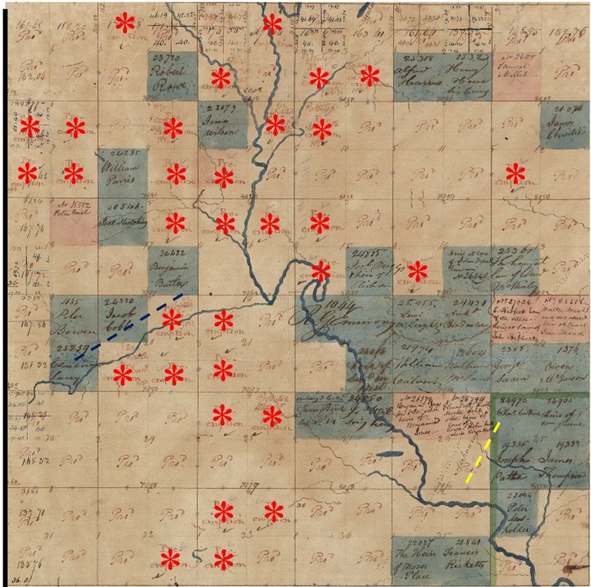
Rice-Upshaw House: Courtesy Joan L. Gould - Examples of Historic Documents from Regional Archives

               “The advantage of local studies…is the wealth of detail they can provide…
               By getting to know these people intimately, scholars can better understand
                what motivated them and interpret their behavior with more confidence.
                    They can flush out local stories to provide insights denied them
                                when taking the longer view of events.”

   		   Daniel E. Sutherland, Ph.D.
							Department of History, University of Arkansas, Fayetteville
							 Guerrillas, Unionists & Violence on the Confederate Homefront, 7.
						  (Fayetteville: University of Arkansas Press, 1999)

     Introduction
     In the opening years of the nineteenth century the founding families of Lawrence County
     transformed a vast upland wilderness then known as the White River Country into one of
     the richest agricultural regions of the trans-Mississippi West. Their lives were not simple,
     and neither is their history. Their experiences, contributions, and legacies have not been well
     documented in the history of America’s westward expansion.

     For the past three decades a coalition of local researchers has worked to better understand and
     document the history of this region’s first phase of American settlement by stepping back in time
     to explore their social, cultural, economic, and political worlds. A deeper plunge into this largely
     forgotten past has allowed us to “flush out,” to borrow historian Daniel Sutherland’s words, new
     insights into their lives.
Our coalition of researchers includes Dr. Blake Perkins of Lynn, Arkansas; Joan L. Gould of
Fayetteville, Arkansas; Steve Saunders of Imboden, Arkansas; and Robert A. Myers of St. Louis,
Missouri. Perkins and Gould are serving as editors for the project.

Our research begins with the settlement of the vast White River Country of present-day northern
Arkansas and southern Missouri in 1800. It incorporates the formal organization of Lawrence
County by the U.S. government of Missouri Territory on January 15, 1815 and extends through
1836, the close of the territorial governance of Arkansas.

The genesis of Lawrence County
Robert A. Myers provides a summary of Lawrence County at its conception. Following the
Treaty of Fort Osage in 1808 in which the Osage ceded approximately 50,000 square miles
of tribal territory to the United States, American migrants began pouring into the White River
Country. Created in 1815 within the Missouri Territory from the western three-quarters of New
Madrid County, the boundaries of Lawrence County adjoined New Madrid County to the east,
Cape Girardeau County to the north, the remaining Osage tribal lands to the west, and Arkansas
County to the south and southeast. Lawrence County initially encompassed more than 21,000
square miles (nearly 13.5 million acres), an area the size of Ireland. Four years after its creation,
on July 4, 1819, the majority of Lawrence County was included in newly created Arkansas
Territory, though its portions north of the 36° 30’ were included in the new state of Missouri.
As an important ancestral hearth of early American settlement west of the Mississippi River, the
story of territorial-era Lawrence County is significant to both Arkansas and Missouri history.
Known as a “mother county,” the geographic area comprising the original Lawrence County
takes in all or an appreciable part of the following 42 modern counties:

Missouri counties

Wayne, Butler, Carter, Ripley, Shannon, Oregon, Howell, Douglas, Ozark, Christian, Taney,
Stone, Lawrence, Barry, Jasper, Newton, and McDonald

Arkansas counties

Clay, Greene, Craighead, Poinsett, Cross, Woodruff, Jackson, Lawrence, Randolph, Sharp,
Independence, White, Cleburne, Stone, Izard, Fulton, Baxter, Marion, Searcy, Newton, Boone,
Madison, Carroll, Washington, and Benton

Unfortunately, as governmental divisions carved up the original land mass – two territories
moving toward statehood and new counties created with new seats of justice - the history of
the “mother county’s” settlement period largely faded into the shadows. Missouri history is
now virtually silent about old Lawrence County, seemingly because it ceased to exist as part of
Missouri after July 3, 1819. Though Arkansas history recognizes Lawrence County as a northern
gateway for the state, it tends to under-appreciate Lawrence’s pre-1819 existence and often
marginalizes its significance in territorial-era accounts that focus more closely on the Arkansas
River Valley.
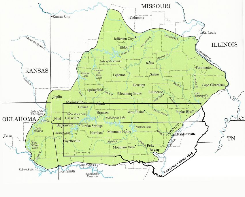
Lawrence County’s 1815 Footprint on the Ozarks Region
           Steve Saunders overlaid Lawrence County boundaries on a regional map
     produced by Emilie Burke and Jim Coombs, Maps & GIS Unit, Missouri State University.
                       Courtesy of Steve Saunders, Imboden, Arkansas;
              and OzarksWatch, Missouri State University, Springfield, Missouri.

Erasing Boundaries means just that…erasing boundaries
Confronting the many misunderstandings of Lawrence County’s territorial
period largely determines the framework for our project. Our challenge has been
to chronologically organize scholarly research that brings the early-nineteenth
century world into sharper focus and, ultimately, interpret the county’s far-
reaching history with greater accuracy.

Historical understanding of earlier time periods is often impeded by both
physical and psychological boundaries built by humans and governments.
Guided by a philosophy of “erasing boundaries,” this project’s researchers have
been working for years to open new windows on Lawrence County’s territorial
history from scattered fragments of primary sources discovered in archives and
other repositories throughout the United States. Piecing together and making
sense of this research has been a longtime collaborative effort in which             Shuttered window
many ‘new discoveries’ have surfaced and fresh historical perspectives have         Rice- Upshaw House
                                                                                  Courtesy Randy L. Tipton
continually evolved.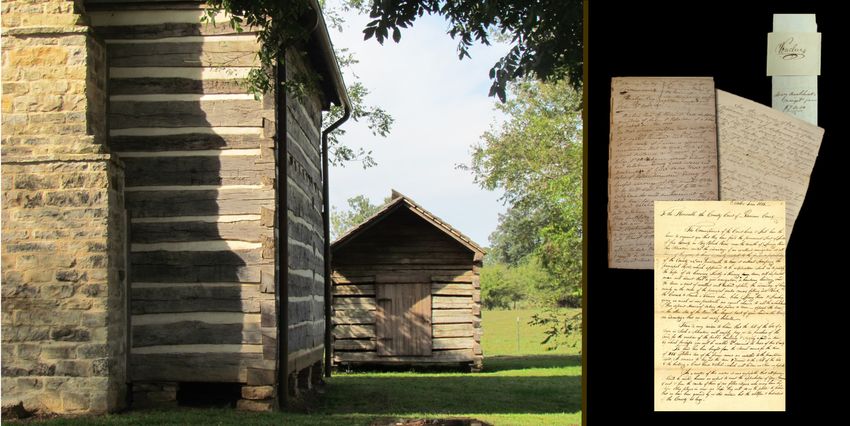
Foundations of the project
Starting in 1829-30, when the seat of justice for Lawrence moved from Davidsonville to
Jackson, the thousands of extant territorial documents were relocated numerous times to different
courthouse vaults and archives. Over the past two centuries a cadre of volunteers has diligently
labored to preserve them. Our Erasing Boundaries project is dedicated to these volunteers, some
whose names are known to us while others remain unknown. We commend their devoted efforts
that made this project possible.

In 2011 the primary group of Lawrence County records found a permanent home under the care
of certified professional archivists when the Northeast Arkansas Regional Archives (NEARA),
opened to the public in a purpose-built building within Powhatan Historic State Park in
Powhatan, Arkansas. NEARA is a division of the Arkansas State Archives located in Little Rock,
Arkansas.

Although the resulting Lawrence County history is
extensive, only a small portion of our overall research
for the project has been included on the website. One
of the foundations has been formed from research
essays submitted for The NEARA Award for Exemplary
Archival Research competition sponsored by the Arkansas
Historical Association. The award is funded by the family
of Eugene Sloan (1892-1981), a Jonesboro lawyer who
was born in Powhatan, Lawrence County. Members of
the Sloan family were frontier founders of Lawrence
County. The award was established in 2013 to honor
Lawrence County Historical Society volunteers who saved
the territorial records when the Lawrence County seat at
Powhatan was abandoned in 1963. The volunteers lobbied
many long years for the establishment of the regional
archives, a branch of the Arkansas State Archives.

In addition to The NEARA Award submissions, research articles contributed by our coalition of
researchers in regional and state publications have been mined and incorporated into the project’s
narrative content. Numerous historic maps, along with original land surveys conducted by the
U.S. Bureau of Land Management’s General Land Office, provide important perspectives on the
period. Various state-sponsored multi-discipline modern studies provide documentary evidence
along with additional resource suggestions to encourage educators, students, parents and the
interested public to learn more about the significance of this region in early American history.

Funding for the project has been provided by generous donations from local historical
organizations and private individuals, including many descendants from Lawrence County’s
founding families.
Evolutionary TIMELINES provide clarity
There has been no attempt to include in their entirety all of the articles, family histories, and
other research studies, for this would be an overwhelming and impossible task. Dr. Blake
Perkins and Joan L. Gould have mined, edited, and selectively arranged information from
these materials into, as much as possible, TIMELINE divisions for the sake of clarity and
historical comprehension. The TIMELINES reveal how events shaped the complex history and
evolutionary development of territorial Lawrence County. Chronological arrangement especially
aids in clarifying the often confusing change of U.S. governance, from its founding as part of
Missouri Territory from 1815 to 1819 and its inclusion in Arkansas Territory from 1819 to 1836.
Numerous travelers passed through Lawrence during the territorial period and recorded their
first-hand impressions of the place and its people. The project editors have included many of
their observations and accounts within appropriate timeline divisions. For example, in the 1815 –
1818 TIMELINE readers can learn more about prominent Missourian Rufus Easton, who toured
Lawrence County in 1817 and declared it to be “one of the best countries in the known world.”

    Example below is one of five TIMELINE divisions for territorial Lawrence County history:

Embracing the modern world
Twenty-first-century technology opens access to digital archives, complete with powerful
search engines, enable us to connect with resources previously restricted by time, travel, and
expense. Supporting documentation from national archives – Library of Congress, Bureau of
Land Management, and a wealth of historic newspapers, to name only a few examples - can be
accessed now like never before. ]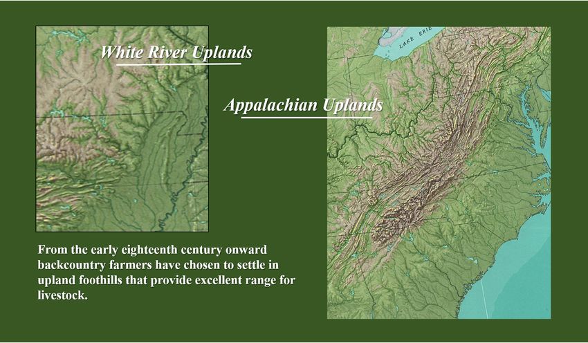
Thus, Erasing Boundaries researchers determined that publishing in a digital format via the
World Wide Web will enable outreach to a virtually unlimited audience, as well as being more
readily accessible to hearing/visually/physically-challenged individuals. This digital format,
more so than publishing in print, also enables hyperlinking and weaving together historic events
and modern studies with actual primary sources that tell those stories.

An abbreviated version of the more comprehensive website will be developed for use on smart
phones and other hand-held devices. This abbreviated version will provide links to the main
website for more detailed accounts and sources.

Challenges for reading historical documents
Reading early-nineteenth century documents, while highly rewarding, can be a challenge. For
example, use of the long ‘s’ is found in numerous early Lawrence County documents, which was
common for centuries in handwriting. The long ‘s’ ( ſ ) is an archaic form of the lower case letter
‘s’ and usually preceded a short ‘s’ either in the middle or at the end of a word. Two excellent
examples of the use of the long ‘s’ are found in the spelling of ‘Congress’ in the U. S. Bill of
Rights and ‘Missouri’ in the Lawrence County document produced in the beautiful handwriting
of Lewis de Mun, the first Lawrence County Clerk.

Probate records present additional challenges. Probate records are court records created after an
individual’s death that relate to a court’s decisions regarding the distribution of the estate to the
heirs or creditors and the care of dependents. Such records open windows to better understand
everyday life and, especially for Lawrence County, underscore the ‘middling’ status of most
of the earliest white settlers. Over 2,460 probate records for the territorial period of Lawrence
County are preserved at the Northeast Arkansas Regional Archives (NEARA) with over 36 cubic
feet of documents. Dozens of these records with inventories of personal property have been
carefully reviewed by Erasing Boundaries researchers. Probate inventories frequently included
spinning wheels and looms for making cloth, shoemaking tools, plows, books, and a host of other
items that speak to the socioeconomics of many early settler families with property.

Probate records frequently include terminology that is unfamiliar in today’s world yet was
common in the everyday language of early settlers. The Erasing Boundaries website makes
generous use of sidebars for definitions to aid the reader. Pewter was a common part of the
tableware of ‘middling’ families and as such is listed on numerous territorial period probate
inventories. We found “Dirt pots” translates to pottery pots made from clay; hackles were used
to comb the fibers of the flax plant, just one of the numerous steps in making linen; and piggens
fashioned by a cooper served numerous functions for both the housewife and the farmer.
The above examples illustrate material culture common to families of territorial Lawrence County.
The mocha decorated sherd of pottery, second from left, was found by archeologists at the Rice-
Upshaw House and represents, along with the pewter, far left, items from outside markets. The
lead shot mold, also found at the Rice-Upshaw House, was hand-crafted by a Rice blacksmith.
Hackles and piggens, right above, were usually locally-produced by skilled farmers.
Basic questions – who, what, when, where, and why
In the early years of the 19th century, Lawrence County was the ‘new country’ offering American
families opportunities for pursuing hopeful futures or escaping unfortunate pasts. Territorial-
era records bring out long forgotten names and places while shedding light on the relevance of
certain events of the era that have heretofore been lost in the annals of history. Unfortunately, as
we attempt to understand the world of early American settlers, we often find that these records
do not always provide adequate details to capture societal and technological changes over time.
Thus, we have employed some explanations of cultural contrasts when deemed necessary. We
also use historically period-specific paintings, drawings, and sketches for illustration, such as
work by 19th century Missouri artist and politician George Caleb Bingham. Obviously, actual
photographs did not come into use until well after the county’s territorial era.
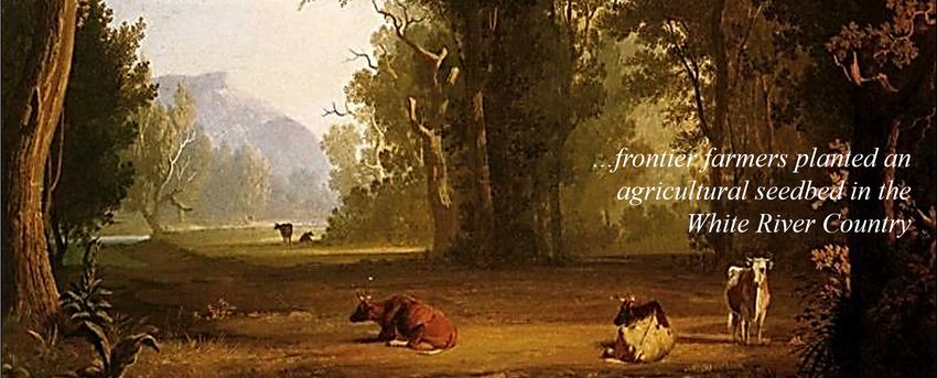
George Caleb Bingham (1811 – 1879), one of America’s most noted artists of the 19th
century, captured cattle grazing along the bank of a stream that represents the open
range for livestock, a part of the agricultural heritage of territorial Lawrence County.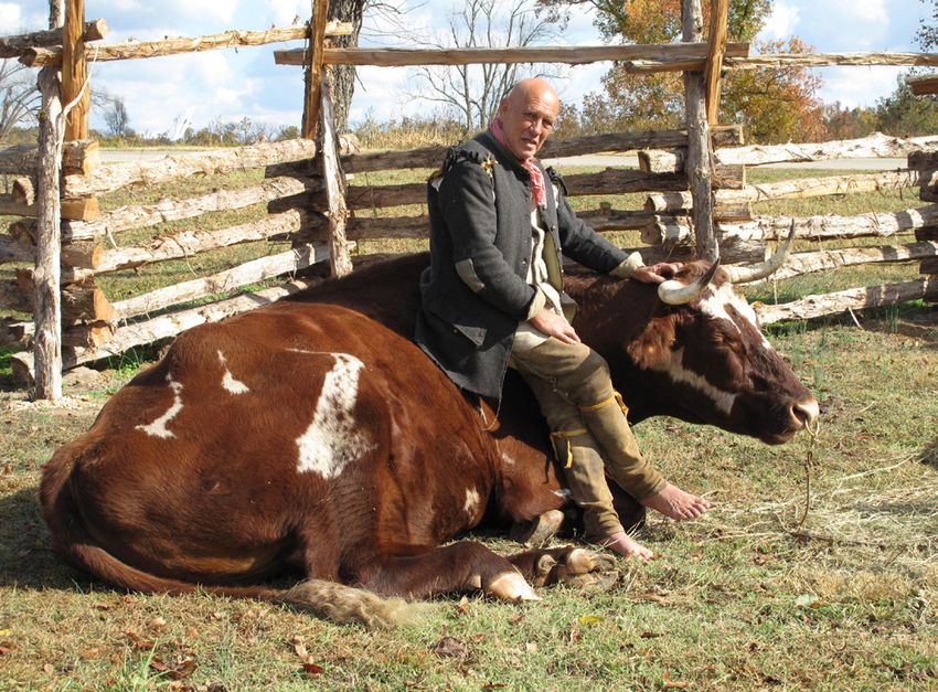
Providing a framework for future studies
Within each TIMELINE, Erasing Boundaries editors have added TAGS to highlight both
famous and not-so-famous individuals and events. These highlighted topics are intended to
inform interactive readers of Lawrence County’s broader impact on trans-Mississippi settlement
history.

        “It’s easy to forget history happens at every level of society.
                     We spend so much time focusing on
             presidents, generals, celebrities, and entrepreneurs
                  that we forget about the ordinary people.
              There’s plenty of treasure in your own backyard
                         if you know where to look.”
                                                                                 Taylor Harbin
                                                                        NEARA Archival Assistant

Our research and historical interpretation efforts have been years in the making. It became
apparent early on that rushing the project to completion would be an impossible (and
irresponsible) task. As our work with primary sources and improved understanding of the period
evolved over time, significant details and incredible connections in this history have surfaced. To
point out but one example, we only recently opened a probate file from NEARA in Powhatan that
exposed a wealth of fascinating information on early commercial activity in Lawrence County.
Specifically, these estate records not only connect Missouri and Arkansas territorial history but
unexpectedly identify the region’s earliest documented potter who, after two centuries, emerged
out of the shadows. We were ecstatic!

             But the time has come to move out of the ‘stacks’!
Indeed, as passionate researchers constantly making new discoveries, we often struggle to move
out of the ‘stacks’ of research and on to the phase of distilling and publishing our findings to
a broader audience. Our efforts - Erasing Boundaries: The Forgotten History of Territorial
Lawrence County in the Trans-Mississippi West, 1815-1836 – should, therefore, be viewed
as merely a beginning. Further research will always beckon future scholars, and we hope this
project encourages a new wave of historical exploration into Territorial Lawrence County’s
forgotten past.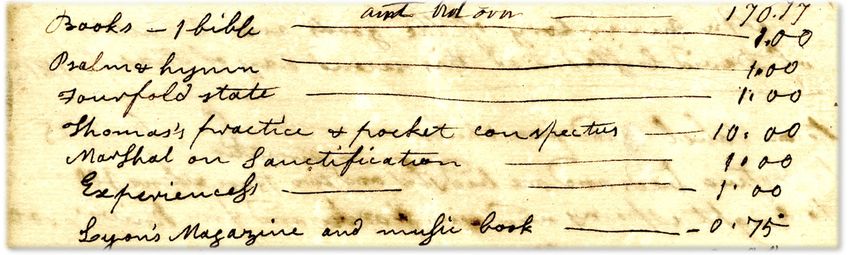
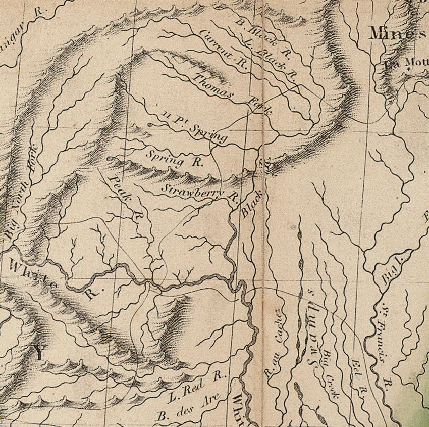
Extraction from 1816 John Melish Map; Courtesy of the Missouri State Archives

                     “…one of the best countries in the known world.”
                                         Rufus Easton
                                       Missouri Gazette,
                                July 26, 1817, page 2, column 3

The Erasing Boundaries website, rich in images of documents, historic maps, and material
culture, illuminates more than simply the identities of founding families, governmental officials,
and historic events of Lawrence County. It opens windows on the character, everyday lives, and
legacies of the people who, as noted Missouri politician Rufus Easton pointed out in 1817, made
this region of the trans-Mississippi West into “one of the best countries in the known world.”

American settlers and their toolkit of skills
The majority of the region’s first American settlers had pushed westward from the Appalachian
uplands. They chose a similar setting in which to plant their roots - an uplands region commonly
known then as the White River Country.

When American families first crossed the Mississippi River, the uplands they settled were not yet
popularly identified as the “Ozarks.” John Melish’s 1816 Map highlights the ancient land route
originally developed by Native Americans called the Natchitoches Trace, which passed through
the rich fertile river valleys of the White River Country. Melish, a Scottish mapmaker, produced
some of the most accurate maps in early America. His map is but one of many featured on the
Erasing Boundaries website.
Small numbers of French settlers had advanced into the White River County in the late
eighteenth century, when the broader Louisiana Territory remained part of the Spanish Empire
and then Napoleon’s France from 1800-1803. These French settlers were followed by a rush
of American migrants after the United States’ Louisiana Purchase and the 1808 Treaty of Fort
Osage. The vast majority of these Americans were yeoman farmers who had moved westward
from the Appalachian uplands through
Kentucky and Tennessee over the past
decades, though a few came from other
parts of the U.S. back east, including
New England. Many were of Scots-Irish,
German, and English ancestry. Some
of these Euro-Americans had inter-
married with Native Americans. Some
Native American groups from back east,
including Cherokees, Shawnees, and
Delawares, resided in the region as well,
having been pushed out by U.S. expansion
from ancestral homelands east of the
Mississippi. Several American settlers
brought enslaved blacks to the region,
descendants of an array of African ethnic
groups and heirs to distinctive African-
American cultures that had evolved over
the past two centuries. Among the region’s
first black settlers were also a very small Extraction from John Melish 1816 Map;
Courtesy of the Missouri State Archives.
number of free African Americans. All
contributed to remarkable ethnic and
cultural diversity and the syncretic development of early Lawrence County society and culture.
John Melish’s 1816 map depicts the ancient the Natchitoches Trace winding its way through
the eastern White River Country. The trace, named for the Caddo-speaking Natchitoches
Indians, was mostly a foot-path that led from the mouth of the Missouri River to the Red River
Valley. The map documents the trace crossing the Black, Current, Thomas Fork, Eleven Point,
Strawberry, White, Little Red, and St. Francis rivers in what had become Lawrence County
in 1815. Over time, local names associated with routes along the original trace changed many
times, often differing on either side of the boundary separating the governmental divisions of
Missouri and Arkansas.From 2017 presentation
Cultivating Life: Agricultural History of Northeast Arkansas
Sponsored by the Arkansas State Archives
A rage to move
It was the pre-historic trace and the White River, a major tributary of the Mississippi River,
that carried early settlers to the riches of the White River uplands. Henry M. Brackenridge,
a St. Louis lawyer, wrote in the spring of 1810 that many American families had “removed”
southward to the “White River country,” noting “there seems to be a rage amongst the frontier
men for emigrating to that quarter. The most favorable reports are made of it.”* By January 15,
1815, the swelling population in the region justified the political creation of Lawrence County by
the territorial Missouri General Assembly in St. Louis.
What inspired these American families with a rage to move to the White River Country? One
compelling draw was the upland hills and valleys that provided excellent range for their livestock
herding and small farming practices. A combination of abundant forests and relatively rich
lands in the narrow creek and river valleys proved ideal for the skills and cultures that many
migrant’s brought with them from Appalachia back east. Another attractive feature of the region
was its numerous spring-fed rivers and streams that flowed freely throughout the region. These
waterways, celebrated still today for their natural beauty, made the region rather unique in the
trans-Mississippi West, reminding many American settlers of the Appalachian uplands from
which they had come.
* Henry M. Brackenridge, Views of Louisiana; Together With a Journal of a Voyage Up the Missouri River, in
1811 (Pittsburgh: Cramer, Spear and Richbaum, 1814) 29, 67, 69, 84, 116, 130.Families and their ‘connections’ Since ancient times, migrations have typically involved groups of people moving together for mutual support. The same held true for the founding American families of Lawrence County. In fact, our research reveals that the majority of these families migrated in kinship groups from one American frontier region to another, often for multiple generations, before crossing the Mississippi River and arriving to settle in Lawrence County. As we gathered individual family histories over past decades, we shared these findings with one another and soon realized that the founding families of Lawrence County had incredible stories with great significance to the broader narratives of American history. This research contributes new findings and perspectives to historians’ longtime efforts to better understand the character, settlement patterns, and impacts of migrant agriculturalists as they moved west from the Atlantic coast in the early nineteenth century. We quickly recognized that zooming in on this region’s settlement history adds a great deal the broader story of early American history. Many of Lawrence County’s earliest American settlers and their descendants had been part of opening nearly every new western frontier since colonial times. Most were ‘middling’ land- owners who represented Thomas Jefferson’s ideal of the independent yeoman farmer. Some of Lawrence County’s older settlers had served the Patriot cause during the Revolutionary War. Long imagined as backwoods simpletons isolated from the broader currents of American history, the region’s early-19th century settlers have too often been misunderstood and under-studied. This website intends to help reconsider and hopefully correct many of these misconceptions. Our research includes an in-depth independent study titled “The Way West: Migratory Pathways to the Trans-Mississippi,” which will be included under the website’s 1800 – 1814 TIMELINE as a downloadable PDF.
“I have had in my mind, as many of us do,
          the single ox cart heading out into the great unknown.”

                                                                             Christopher Baker
                                                                      Descendant of Elisha Baker

One example from “The Way West” provides new insights for Christopher Baker of Columbia,
Missouri, a descendent of early settler Elisha Baker. Elisha had been a signer of the 1796 State
Constitution of Tennessee, and several of his family members were listed on the 1815 & 1816
Lawrence County Tax Lists. Baker and his family initially moved to Spanish Louisiana in the
late eighteenth century from the Holston River Valley in Tennessee. Christopher Baker always
imagined that his early kinfolk had traveled west alone as individualistic pioneers and without
specific plans and simply wound up in Lawrence County. As we researched his family history
with him, he came to view his ancestors’ adventures in an entirely new light; now he can
follow them and their inter-connected neighbors westward from the Appalachians to Missouri’s
Bellevue Valley, where they and multiple neighbors embraced what Henry M. Brackenridge
had called the “rage to move” to the White River Country. Among the Bellevue Valley families
claiming land pre-emptions in Lawrence County were Baker, Davis, Janes, Job, Ottery, Reed,
Rickman, and Sloan.

Another significant example of better understanding the history of group migration and
settlement is the 1930s commemorative stone marker standing near the Strawberry River near
present-day Jesup and Smithville. The marker honors the inter-connected families of James
Finley, Samuel Raney, Jacob Fortenberry, and William Taylor. An inscription at the top of
the stone reads: “Dedicated to the memory of the four below named pioneer families by their
descendants…” and declares that all are buried near their homesteads.

                                                                    Photographs courtesy of
                                                                    John Fortenberry, Maxine
                                                                    Fortenberry, The Fortenberry
                                                                    family in Arkansas: A review
                                                                    of the history and legacy
                                                                    of six generations. J. and
                                                                    M. Fortenberry (January 1,
                                                                    1997).
Opening a new frontier was “…a horrendously difficult task”
Living history enactor, educator, and author Gerry Barker, shown below at The Rice-Upshaw
Restoration Site (near Dalton, Randolph County, Arkansas), interprets the ‘toolkit of skills’ early
American settlers possessed that enabled them to quickly transform the region into a significant
American agricultural seedbed. Their
history played out along the narrow but
fertile valleys of the numerous spring-fed
rivers. This “toolkit of skills,” as Barker
points. out, prepared American settlers—
black and white, men, women, and
children—for “…a horrendously difficult
task.” The legacies of their labors persist,
despite constant change, in the region
today.
Photograph courtesy of Tommy Jameson,
AIA, preservation architect, Little Rock,
Arkansas.
Material culture with a story to tell
Chasing migrants’ ancestral roots reveals that these American first-comers were often third or
even fourth generation landowners of ‘middling’ social status, far from possessing great wealth
but neither were they the poor ‘squatters’ often depicted in stereotypical accounts and imagery.
Many were experienced military leaders, a number had served as state and local government
officials, and most had been trained by their forefathers and mothers in the skills of productive
farming, craftsmanship, and trade.
Currier and Ives 1870 adaptation of “The Traveller and the Squatter”
by Arkansas artist Edward Payson Washbourne
From 2017 presentation
Cultivating Life: Agricultural History of Northeast Arkansas
Sponsored by the Arkansas State ArchivesThe Reuben Rice family loom, shown right,
according to local tradition, arrived in the White
River Country in an 1812 wagon-train of inter-
connected families from Tennessee’s Holston
River Valley. Dendrochronologist Dr. David
Stahle, director of the University of Arkansas
Tree-Ring Laboratory, confirmed that the hand-
crafted loom parts were made of wood that was
not native to Arkansas. A portion of the Rice
settlement site, along with the loom and other
items of frontier material culture, were donated
to Black River Technical College by the James
Upshaw family, who are descendants of early
settlers Reuben and Lydia Rice.
Photography courtesy of Ronnie Walker,
Black River Technical College
Davidsonville – The legendary seat of justice
Though short-lived, Lawrence County’s original seat of justice, Davidsonville, nonetheless
played an outsized role in shaping the history of early American settlement in the region.
Erasing Boundaries details the town’s development and significant
events that breathed life into the early territorial period.
Many of the early attorneys who served in the county’s government and
courts – i.e. Charles S. Hempstead, Jason Chamberlain, Richard Searcy,
and Townsend Dickinson – played influential roles more broadly in both
Missouri and Arkansas history. Our research brings their early careers out
of the shadows and places them in historical context as leading influences
in America’s expansion in the trans-Mississippi West.
Townsend Dickinson, ca. 1835, one of three original justices of the Arkansas Supreme Court.
Portrait courtesy of the Encyclopedia of Arkansas History and Culture.
Davidsonville town plat;
Lawrence County Deed Book B, p. 80;
Lawrence County Courthouse,
Walnut Ridge, ArkansasLand records – relevant to all time periods
The General Land Office records available on the U. S. Department of Interior Bureau of Land
Management website provide a wealth of information for both the historian and genealogist. The
website has been of particular assistance to Erasing Boundaries researchers in confirming the
settlement patterns of the first-comers who spread out along the fertile valleys of the principal
waterways of the White River Country.
The process of surveying public lands of the 1803
Louisiana Purchase territory began in 1815, coinciding
with the formation of Lawrence County. Once the
earliest surveys were completed, the U. S. government
awarded thousands of acres in Military Bounty Land
Grants to eligible veterans for their service in the War of
1812. The government was also anxious to recoup the
cost of the Louisiana Purchase through the sale of land
to private individuals.
Surveyors Prospect K. Robbins and Joseph C. Brown
were commissioned in 1815 to establish a starting
point for all subsequent surveys. This starting point
is preserved as a National Historic Landmark at the
juncture of present-day Lee, Monroe, and Phillips
counties in Arkansas. The team led by Robbins traveled
north from the mouth of the Arkansas River, while
Brown’s team traveled west from the mouth of the St.
Francis River. On October 27, 1815 Robbins’ team
crossed the east–west line laid down by Brown’s team,
formally establishing the Fifth Principal Meridian.*
Robbins continued marking the Fifth Principal Meridian
northward, passing through the most populated regions
The Arkansas Gazette,
Arkansas (Arkansas Territory),
of territorial Lawrence County. Robbins was followed by
September 2, 1820, p. 4, col. 2: a swarm of government-appointed surveyors. From their
https://www.newspapers.com/ field notes General Land Office plat maps (GLOs) were
produced establishing the basis for legal descriptions
of townships, ranges, and sections. Between August and October of 1820 individuals who had
settled land prior to April 12, 1814 could register their claims – called pre-emptions - at the
Lawrence Land Office in Davidsonville, see announcement above. Following the registration
of pre-emptions cartologists in Washington, D.C. marked the pre-emptions on township plat
maps. As a result the county’s earliest GLO plat maps document pre-emptions as well as Military
Bounties, providing insightful glimpses into the earliest American settlement patterns in the
county.
*Louisiana Purchase Historic State Park https://en.wikipedia.org/wiki/Louisiana_Purchase_Historic_State_
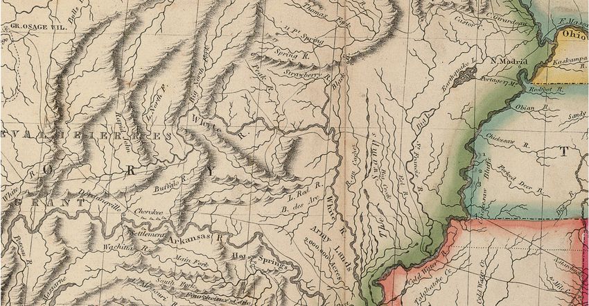
ParkSurveyed October, 1817 by John D. Davidson, Deputy Surveyor
Fifth Principal Meridian
Township 20 North and Range 1 East
The GLO plat map, above, illustrates how Erasing Boundaries editors use the earliest land
surveys to chart Lawrence County settlements, based on pre-emption claims, Military Bounties,
and early roadways. This one six-square-mile township, bisected by Thomas Fork River (aka
Fouche de Maw), documents thirty-two pre-April 12, 1814 land claims, marked with red
asterisks. The yellow dotted line identifies the federally-funded post-road known as the Arkansas
Road.* The ancient Natchitoches Trace passed through the northern sections of this township.
Although the Trace, indicated by a blue dotted line, was not marked on the original plat map,
Lawrence County court records confirm it passed by the pre-emptions of Gabriel Seaver in the
Northwest ¼ of Section 10 and William Russell in Section 20.** The settlement was known as
a rural trading center called Columbia. Court and probate records confirm that both Seaver and
Russell were farmers and distillers of whiskey while Russell also owned a saw and grist mill.***
* The post office in Davidsonville was established in June 1817. Clarence Edwin Carter, comp. & ed., The
Territorial Papers of the United States, Vol. XX, The Territory of Arkansas, 1825 – 1829, (Washington, D.C.:
U.S. Government Printing Office), 489.
** Marion Stark Craig, comp., Early Lawrence County Records 1817-1830 (Conway, Ark.: Arkansas Research,
1995), 2; Land patents: https://glorecords.blm.gov/search/
*** Lawrence County Probate Records: Gabriel Seaver, MSNE,0054 _ B25_F1926; William Russell,
MSNE,0054_ B25_F1888, Northeast Arkansas Regional Archives, Powhatan, Arkansas.Probate records open windows
Estate inventories frequently provide exciting and unexpected discoveries! Adam Ritchey and
his brother-in-law David Lister were likely the county’s first physicians and practiced out of
Davidsonville. Previously in local histories, Ritchey had been identified only as Davidsonville’s
postmaster and a Commissioner of the Courthouse and Jail. In the “Articles of agreement” for
their medical practice, which was composed on March 1, 1817, Ritchey was identified as a
“Surgeon and Doctor of Medicine,” with he and Lister jointly owning the “…Medicines and
shop…” in Davidsonville.
Lister’s death in 1818 resulted in a rare and lengthy listing of the medicines and medical books
they possessed and employed on the frontier. Equally unexpected and rare was the listing in
these probate records of religious books owned by Lister, reflecting the strong connections the
Ritchey and Lister families had with the Presbyterian faith since their arrival in America in the
early 1700s.
1818 partial list the
personal property of
David Lister, deceased:
Lawrence County Probate
Records_ MSNE_B23_F1263;
Northeast Arkansas Regional
Archives, Powhatan, ArkansasSource: Extraction from the 1818 personal property inventory of David Lister, deceased:
Lawrence County Probate Records_ MSNE_B23_F1263;
Northeast Arkansas Regional Archives, Powhatan, Arkansas
The extraction from David Lister’s personal property inventory, above, lists “Lyon’s Magazine
and music book.” Composer James Lyon (1723 – 1794) produced the above Urania, or A Choice
Collection of Psalm-Tunes, Anthems and Hymns in 1761. It was widely disturbed around the world
with one copy in the possession of David Lister of Davidsonville.
Image courtesy of https://library.princeton.edu/jameslyon/exhibit/1761.html
The excerpt above from David Lister’s personal property inventory, lists “Lyon’s Magazine and
Music Book.” Composer James Lyon (1723 – 1794) produced the above Urania, or A Choice
Collection of Psalm-Tunes, Anthems and Hymns in 1761. It was widely disturbed around the
world with one copy in the possession of David Lister of Davidsonville. Image courtesy of
https://library.princeton.edu/jameslyon/exhibit/1761.htmlClosing out the territorial era
The 1830s, the last years of the territorial period, held drama and significance of their own right.
A new seat of justice, Jackson, was erected in what had been an open field and there was held a
murder trial, a hanging, and all the business of a county. Today it has reverted to an open field
and its significance known only to a few local residents.
This was a period of industrial change for the people of the county. Steamboats plying the White
and Black rivers provided access to goods imported from far-off trading centers plus easier travel
for residents and easier transport of local agricultural products to distant markets.
Lawrence County founders were now scattered throughout the American southwest and playing
parts on broader stages. At home a few folks were playing significant roles in national events.
The federal government was constructing new roads and improving old roads for the purpose of
removing Native American peoples from their eastern lands to what was to be their new places
of residence beyond Arkansas’s western border. Two branches of these ‘military roads’ wound
through Lawrence County. With minimum words, a four-line note found in the archival records
at NEARA, documents the role Lawrence County individuals played in the construction of one
of these roadways. Thomas Baker, a son of Elisha Baker who signed the Constitution of the State
of Tennessee in 1796, served as a superintendent of one branch and enslaved African Americans
of Thomas S. Drew were hired as construction workers. They were building what has become
known as the Trail of Tears.
Drew went on to become the third governor of Arkansas from 1844 - 1849. Most unfortunately,
the role of black enslaved workers has been over-looked in this national saga but now records
from territorial Lawrence County can bring their important role to the forefront.
Transcription:
Recd. (Received) of Thos. (Thomas) Baker Supr. (Superintendent) of the Military Road leading
from Jackson via Liberty & Fayetteville to Ft. Smith Road –
by the hand of David W. Lowe, Esq. (Esquire) * One hundred
Dollars for the hire of hands (slaves) Octr (October) 20th 1835.
Thos. (Thomas) S. Drew
• David W. Lowe was the Lawrence County Clerk
Sources: https://digitalheritage.arkansas.gov/exhibits-online-vault-images/57/;
https://encyclopediaofarkansas.net/entries/thomas-stevenson-drew-100/You can also read