Depleting the Deer Creek Aquifer - Evidence supporting A Rapid Decline
←
→
Page content transcription
If your browser does not render page correctly, please read the page content below
Evidence supporting

Depleting the Deer Creek Aquifer   A Rapid
                                   Decline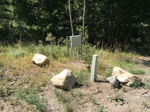
Overview

❖   The Upper Deer Creek Area (1 slide)
❖   Declining Aquifer (2 slides)
❖   Possible Causes of the Aquifer’s Decline
    ❖   Possible causes on lot 182 (2 slides)
    ❖   Larger Scope possibilities (3 slides)
❖   Conclusions (1 slide)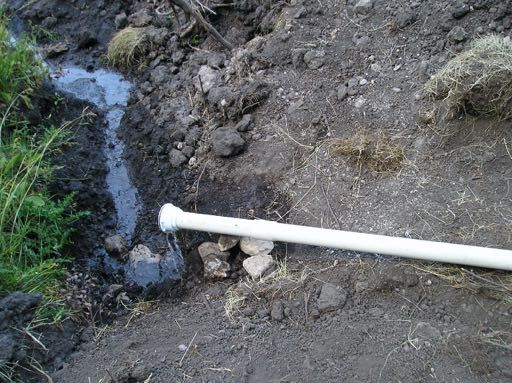
Upper Deer Creek                                                                Wolverine
                                                               Fire Reservoir Pass Road
                                                               and Fish Pond
                                                                                             May
                                                                                             Pavilion
                                                                                             Well

                                                 Smith Canyon Road

❖   Smith Canyon Road follows Deer Creek
    on west of the Lava Ranch subdivision.
                                                  Lot 182 Spring                                                                                          Smith
❖   Prominent faults are:                                                                                                                                 Canyon Fault
                                                       Tobias Seep &
                                                       well
    ❖   Smith Canyon fault                       Bernt Seep                                   Lot 183
                                                                                              spring
                                                                                            Lots
    ❖   Unnamed fault on S. Wolverine                                                       184.185
                                                                                            spring(s)
                                                                                                                                                       Unnamed Fault

                                                         Rising of
❖   Deer Creek rises as springs @ junction               Deer Creek

    of Faults.                                      Stock Well on
                                                    S.Wolverine Pass
                                                    Road

❖   In addition there is a set of springs and
    seeps in the upper Deer Creek drainage.
❖   A stock well has recently begun being       USGS 2013 “Lava Hot Springs Quadrangle, Idaho-Bannock Co., 7.5 Minute Series ”

    used as a community well                    Link, Crane & Oriel, “Technical report 01-3 Geologic Map of the Lava Hot Springs Quadrangle, Bannock County, Idaho”

                                                Crane 200, “GEOLOGIC MAPPING AND GRAVITY SURVEY OF THE LAVA HOT SPRINGS, IDAHO, 7.5 MIN. QUADRANGLE:
                                                EVIDENCE FOR A LATE MIOCENE SUPRADETACHMENT BASIN IN SOUTHEAST IDAHO”
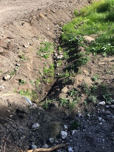
Lot 182 Cistern Overflow Visual Comparison Max
                                                                                        & Min 2016 and 2020

        Declining Aquifer — Qualitative
❖     Lot 182 spring 2000-2006. Lowest flow was 2
      quarts/minute.

❖   Lot 182 spring flow has recently dropped each year.
❖   2020 butterflies no longer attracted to Bernt seep.
❖   Lot 184 spring pool frozen Winter 2021 for first time.
❖   Tobias seep well flow reported down 2020
❖   In the Falls of 2019 & 2020 Deer Creek did not flow to pond
    below Hess lot.
❖   Bernt’s well ran dry in 2000, two tries to find water again
❖   Not a lot of water. Well logs show dry holes and re-drilling after
    producing wells fail (Big Bear area too)

❖   Conclusion: Springs, Seeps, wells and Deer Creek show                Top Row 2016. Bottom Row 2020
    evidence of decline                                                  Left column: 1st Week June.
                                                                         Right column: Last Week October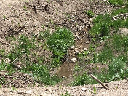
Declining Aquifer — Quantitative
❖   In August 2019, began measuring Lot 182 spring flow.
❖    “Runs Chart” based on 2019 Aug.-Nov. data to compare low
    flow year to year. Features:
    ❖   A trend when 5 measurements in a row below average.
    ❖   +- 3 std. deviations includes all baseline data
❖   How did 2020 Aug.-Nov. do?
    ❖   Late Aug. 5 in a row below average!
    ❖   Early October outside of -3 std. deviation limit
    ❖   Has stayed below -3 std. deviation limit since.
    ❖   2021 NOT seeing recovery like in March 2020!
❖   Conclusion:
    ❖   95% confidence that 2020 worse than 2019
    ❖   Spring 2021 beginning WORSE than worst of 2020.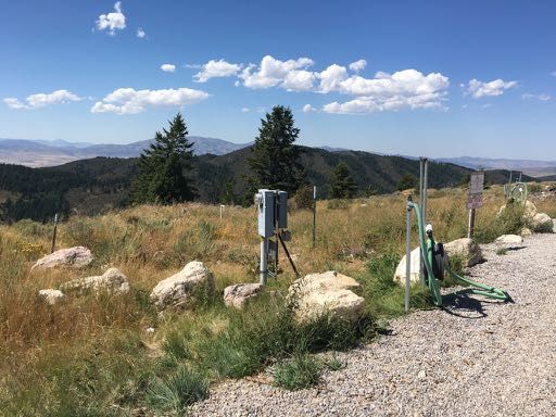
Possible Causes on Lot 182
               Is Spring Development at Fault?
 ❖   Development (more detail in supplemental slides)
     ❖   Designed and constructed with professional engineering input.
     ❖   Passed inspections by county, Dept of Health.
     ❖   Granted water right by Idaho Dept. Of Water Resources (IDWR).
 ❖   System worked flawlessly 2006-2016.
 ❖   Maintenance & inspection (more detail in supplemental slides)
     ❖   Little that can go wrong, gravity fed.
     ❖   Summer 2019 in-depth inspection — everything as built.

 ❖   Conclusion:        Due diligence for design & implementation.
     Proper inspection, licensing, maintenance & operation.
Possible Causes on Lot 182
                                  Is the Lot 182 Spring Transient?
  ❖     Oral history for spring begins at time of Lava Ranch Subdivision in 1978
        ❖    Realtor (Jay Anthony) sold lot 3 times. “spring was there and active,
             including drought years”.
  ❖     The spring is in a mound of soil 2-3 feet high. Some soil’s accumulation rate
        is approximately 1mm (1/25”) per year
  ❖     Inspection of lots and road easement: No new springs to pirate the flow.

  ❖       Conclusion: Nothing found that indicates the spring is less than
          ancient.

 Arjun M.Heimsath, WilliamE. Dietrich, Kunihiko Nishiizumi, Robert C.Finkel. “Cosmogenic nuclides, topography, and the spatial variation of soil depth”, Geomorphology, Volume
 27, Issues 1–2, February 1999, Pages 151-172
Larger Scope Possibilities
                                                                 https://wcc.sc.egov.usda.gov/reportGenerator/view/customGroupByM onthReport/monthly/741:ID:SNTL% 7Cid=% 22% 22% 7Cname/POR_BEGIN,POR_END/PREC::value

                                                                 https://wcc.sc.egov.usda.gov/reportGenerator/view/customGroupByM onthReport/monthly/867:ID:SNTL% 7Cid=% 22% 22% 7Cname/POR_BEGIN,POR_END/PREC::value

                                                                            Total Precipitation in August of Water Year for

          Is There a Drought?                                                                      50
                                                                                                                    Selected Locations

                                                                                                   40

                                                                            Inches Precipitation
❖   SNOTEL system measures precipitation. Two nearby                                               30

    stations:
                                                                                                   20

    ❖   Wildhorse divide outside of Pocatello. Elevation 6490’                                     10                                                          Wildhorse Divide
                                                                                                                                                               Sedgewick Peak
    ❖   Sedgewick peak, East of Dempsy Creek. Elevation 7850’                                       0
                                                                                                    1980                1990                2000                            2010                          2020
                                                                                                                                          Water Year
❖   The Sedgewick peak data 1989-2019 was analyzed.
                                                                            Total Precipitation in August of Water Year for
    ❖   The data point error bars show +- 3 std. deviations (+-3!)                                         Sedgwick Peak and Trend Line
                                                                                                   50
                                                                                                        y = 0.0381x - 46.072
    ❖   The only excursions below -3! are 2001 and 1992                                                      R² = 0.0028
                                                                                                   40

                                                                            Inches Precipitation
    ❖   The only excursions above +3! are 2016, 2011 and 1997                                      30

    ❖   For 2010-2019, 2018 was the lowest, 2017 and 2019 were                                     20
        highest, 2001 and 2017 significantly so.
                                                                                                   10

❖   Conclusion:          Currently no indication of drought at Lava                                 0
    Ranch.                                                                                          1980                1990                2000
                                                                                                                                          Water Year
                                                                                                                                                                            2010                          2020
Larger Scope Possibilities
                           Nearby Well Activity Changes
 ❖   The IDWR requires that well drillers log all wells drilled in the state.
     ❖   A website lets anyone look at activity and results. (May not include older wells)
     ❖   There has only been one new well drilled in the Lava Ranch area for the period 2016-2019.
         It was drilled in 2018 and is on Big Bear Road, for domestic use.
     ❖   A new well was drilled in 2020 to the NNW of lot 182 outside of Lava Ranch. It produced
         less than 2 GPM at 40 feet, was drilled to 600+ feet with no further water and backfilled to
         40’. The output has declined since.
 ❖   Only known change in well activity is repurposing of the LRPOA stock well in 2016

 ❖   Conclusion:      The new wells could not have caused a decline beginning in 2016. Some
     Deer Creek wells may be seeing declining water production.

            https://idwr.idaho.gov/Apps/appsWell/WCInfoSearchExternal/default.aspx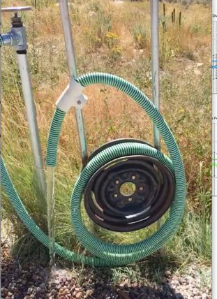
Larger Scope Possibilities
  LRPOA Stock Well Use?
❖   Beginning in 2016, the Lava Ranch Property Association (LRPOA)
    began using a preexisting stock well near the junction of Smith
    Canyon and Wolverine Pass Roads as a community water source.
    ❖   This well is on the unnamed fault at the S. end of Wolverine
        Pass Rd.
    ❖   Water is pumped from the well to two 1700 gallon storage
        tanks at the N. end of High Country Rd..
❖   Any of hundreds of Lava Ranch property owners are encouraged
    to take up to 250 gallons at a time (honor system).
    ❖   At times the demand has exceeded the capacity of the well
        pump.
    ❖   An unknown yearly or daily amount of water is withdrawn.

❖   Conclusion:        This is the only investigated cause that fits the
    data for both time frame of change in water usage and proximity
    to lot 182.                                                            “Upgraded Water Supply”, June 2016 Lava Ranch newsletter
Conclusions:
❖ The Deer Creek Aquifer being depleted. There is not enough water. This is fact, not anyone’s fault.
❖ The amount of water taken from the aquifer must be decreased.
❖ Uncertain what the aquifer is capable of and how much is being removed.
❖ Repurposed LRPOA stock well central to the Deer Creek Aquifer depletion.
❖ In a geologically influential position.
❖ Timing of repurposing coincides with the beginning of decline.
❖ High impact, the only well that has hundreds of users.
❖ The water right for the spring on lot 182 has been infringed.
❖ Amount of water has dropped dramatically. Worse year by year.
❖ Water availability will soon be zero minimum (2021).End of Presentation
Supplemental Slides
Supplemental
         Lava Ranch Lot Key
❖   This shows the location of
    ❖   Lava Ranch Property Owner’s
        Association (LRPROA) stock well
    ❖   High country tanks
    ❖   Lot 179 well logs have been mistaken for
        LRPOA stock well
    ❖   Red, green and blue lines: LRPOA roads
    ❖   Black lines: Country roads
    ❖   Diagonal shading: common areas
Possible Causes on Lot 182 Supplemental
Was the Lot 182 Spring Improperly Developed?
❖ Gravity fed from spring pool to cistern. Cistern (used to) overflow to
Deer Creek. Pump up to cabin from cistern. Cistern
❖ Diversion of spring flow possible for inspection and measuring
❖ Development followed advice of John Beer, a licensed Civil Engineer
with 50+ years experience in municipal and private water systems.
❖ Development done by Gale Allred, DBA Eagle Excavating 2006.
Diversion Valve
❖ Spring plumbing approved by Bannock County Plumbing Inspector
Chris Critzer.
❖ Spring development inspected and approved by S.E.I. Health
Department. Diversion Overflow
(Spring flow
❖ The Idaho Department of Water Resources (IDWR) inspected the measurements)
developed spring and issued a water right.
❖ Since 2005 the Lot 182 spring has operated 24/7, 52 weeks a year.
Met domestic needs until after 2016. Flow from Spring Pool
❖ Conclusion: Due diligence for design & implementation. Proper
inspections/licensing performed.Possible Causes on Lot 182 Supplemental
Is the Lot 182 Water System Properly Maintained?
❖ Summer 2019 the system was partially excavated for
inspection:
❖ Spring pool and perforated pipes inspected, no
obstructions, spring pool at expected elevation. O.K.
❖ Cistern drained and inspected. No leaks, Pump
connected. OK.
❖ Overflow system excavated and inspected. O.K.
❖ Conclusion: System still functioning as designed.Supplemental
Flow Rate Unit Comparison
Converting One Flow Rate to Other Flow Rate Units
Gallons/ Gallons/ Gallons/ Gallons/ Cubic ft/ Cups/min
day hour min sec sec
Well per day 2500 104.17 1.74 0.03 0.00 27.78
LRPOA DECREE 250 10.42 0.17 0.00 0.00 2.78
Lot 182 water right 25853 1077.19 17.95 0.30 0.04 4.79
Pre 2016 lot 182 720 30.00 0.50 0.00833 0.00111 8
summer min
1 quart/min Flow 360 15.00 0.25 0.00417 0.00056 4
RateSupplemental
Cistern Filling Times as a Function of Flow Rate and Use
Spring Flow Rate vs. Cistern Filling Characteristics Spring Flow Rate vs. Cistern Filling Characteristics
(continued
Use rate (gallons/day) 250.0 360.0 720.0
❖ Left hand column — fill rate Fill rate Gallons Days to Days to Days to Days to
Use rate (gallons/day)
Fill rate Gallons Days to
250.0
Days to
360.0
Days to Days to
720.0
(cups/ /day Fill deplete @ deplete @ deplete @
cups/min. 2nd column in min) Empty
1500
250.0
gallons/da
360.0
gallons/da
720.0
gallons/da
(cups/m /day
in)
Fill
Empty
deplete @
250.0
deplete @
360.0
deplete @
720.0
1500 gallons/da gallons/d gallons/day
Gallons/day Gallon
Cistern
y use y use y use Gallon
Cistern
y use ay use use
0.000 0.00 never 6.0 4.2 2.1 4.250 382.50 3.92 always full always full 4.4
❖ Third column is days to fill an empty 0.250
0.500
22.50
45.00
66.67
33.33
6.6
7.3
4.4
4.8
2.2
2.2
4.500
4.750
405.00
427.50
3.70 always full always full
3.51 always full always full
4.8
5.1
cistern 0.750
1.000
67.50
90.00
22.22
16.67
8.2
9.4
5.1
5.6
2.3
2.4
5.000
5.250
450.00
472.50
3.33 always full always full
3.17 always full always full
5.6
6.1
1.250 112.50 13.33 10.9 6.1 2.5 5.500 495.00 3.03 always full always full 6.7
❖ 250 gallons per day is what LRPOA 1.500 135.00 11.11 13.0 6.7 2.6 5.750 517.50 2.90 always full always full 7.4
1.750 157.50 9.52 16.2 7.4 2.7 6.000 540.00 2.78 always full always full 8.3
recommends for lot owners with no 2.000 180.00 8.33 21.4 8.3 2.8 6.250 562.50 2.67 always full always full 9.5
6.500 585.00 2.56 always full always full 11.1
spring 2.250
2.500
202.50
225.00
7.41
6.67
31.6
60.0
9.5
11.1
2.9
3.0
6.750 607.50 2.47 always full always full 13.3
7.000 630.00 2.38 always full always full 16.7
2.750 247.50 6.06 600.0 13.3 3.2
❖ 360 gallons per day is near peak of 3.000 270.00 5.56 always full 16.7 3.3
7.250
7.500
652.50
675.00
2.30 always full always full
2.22 always full always full
22.2
33.3
3.250 292.50 5.13 always full 22.2 3.5
what we have now 3.500 315.00 4.76 always full 33.3 3.7
7.750
8.000
697.50
720.00
2.15 always full always full
2.08 always full always full always full
66.7
3.750 337.50 4.44 always full 66.7 3.9
4.000 360.00 4.17 always full always full 4.2
❖ 720 gallons per day was the
Key
minimum when spring developed Never fills
Not full by next weekend
Full by next weekend
Always fullSupplemental
Faults Near Lava Ranch
❖ Smith Canyon follows the Smith Canyon Fault, a
local basin and range fault
Smith Canyon
❖ Less prominent unnamed fault helps form the side Major Fault forms
axis of Smith
canyon that the southern end of Wolverine Pass Canyon
road comes down
Junction
Wolverine Pass
❖ The intersection of these two faults is coincident and Smith Canyon
with the rising of Deer Creek Roads
❖ Faults crush and weaken rock helping to define Unnamed Fault
South end of
erosion features and drainage Wolverine Pass
GEOLOGIC MAPPING AND GRAVITY SURVEY OF THE LAVA HOT SPRINGS, IDAHO, 7.5 MIN.
QUADRANGLE: EVIDENCE FOR A LATE MIOCENE SUPRADETACHMENT BASIN IN SOUTHEAST
IDAHO
By:
Tracy Jack Crane
A thesis submitted in partial fulfillment Of the requirements for the degree of
Masters of Science in Geology
Idaho State University 2000You can also read