CITY OF RICHLAND NOTICE OF VIRTUAL PUBLIC HEARING (CA2021-105 & EA2021-120)
←
→
Page content transcription
If your browser does not render page correctly, please read the page content below
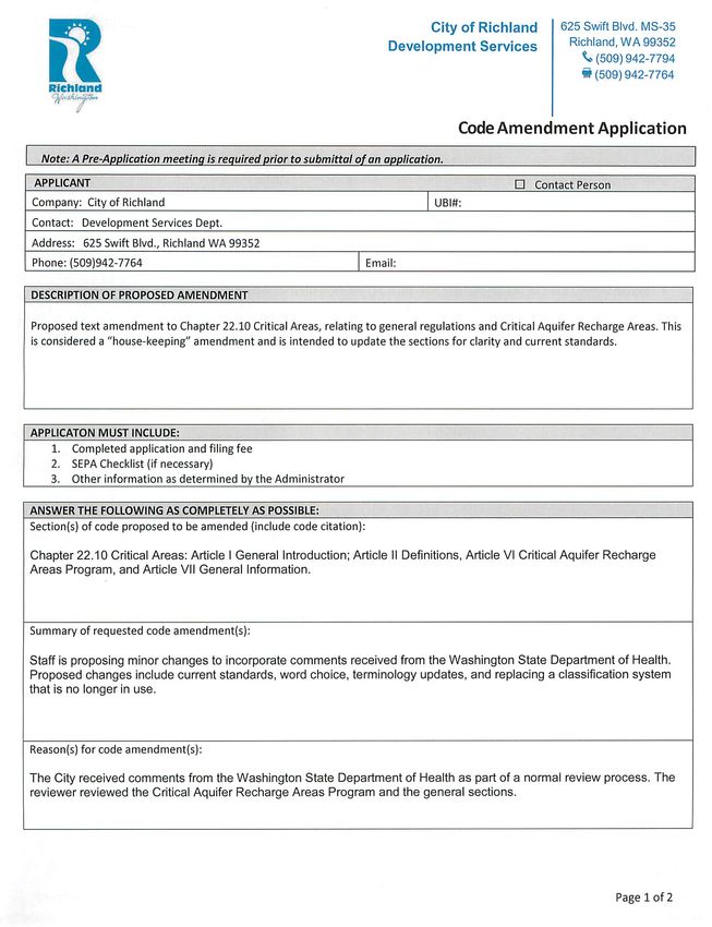
CITY OF RICHLAND
             NOTICE OF VIRTUAL PUBLIC HEARING
                  (CA2021-105 & EA2021-120)

Notice is hereby given that pursuant to RMC Section 19.20, the Richland Planning
Commission will conduct a virtual public hearing and review of application CA2021-105 at
6:00 p.m., May 26, 2021. All interested parties are invited to attend and present testimony
at the virtual public hearing. Those individuals wishing to speak at the public hearing will
need to register by 4:00 p.m. on the date of the hearing by visiting the City of Richland’s
website www.ci.richland.wa.us .

Project Description: The City is proposing a text amendment to Richland Municipal Code
(RMC) Chapter 22.10 Critical Areas, related to general regulations and Critical Aquifer
Recharge Areas. The proposed amendment incorporates comments received from the
Washington State Department of Health.

Environmental Review: The proposal is subject to environmental review. The City
reviewed the proposed project for probable adverse environmental impacts under the
State Environmental Policy Act (SEPA). The City issued a determination of non-
significance on April 6, 2021, and the comment period concluded on April 20, 2021. There
were no appeals of the SEPA determination. The environmental checklist and related file
information are available to the public and can be viewed in the Development Services
Division Office or City of Richland website www.ci.richland.wa.us .

Public Comments: Any person desiring to express their views or to be notified of any
decisions pertaining to this application should notify Mike Stevens, Planning Manager, 625
Swift Blvd., MS-35, Richland, WA 99352. Comments may also be faxed to (509) 942-7764
or emailed to mstevens@ci.richland.wa.us . Written comments should be received no later
than 5:00 p.m. on Wednesday, May 19, 2021 to be incorporated into the staff report.
Comments received after that date will be entered into the record at the hearing.

Copies of the staff report and recommendation will be available on the City of Richland
website www.ci.richland.wa.us beginning Friday, May 21, 2021.
Notice of Intent to Adopt Amendment / Notice of Adoption
Cover Sheet
Pursuant to RCW 36.70A.106, the following jurisdiction provides the following required
state agency notice.
1. Jurisdiction Name: City of Richland – Development Services Dept.
2. Select Submittal Type: 60-Day Notice of Intent to Adopt Amendment.
Select the Type of Submittal
listed. Request of Expedited Review / Notice of Intent
to Adopt Amendment.
(Select One Only)
Supplemental Submittal for existing Notice of
Intent to Adopt Amendment.
Notice of Final Adoption of Amendment.
3. Amendment Type: Comprehensive Plan Amendment.
Select Type of Amendment
listed. Development Regulation Amendment.
(Select One Only)
Critical Areas Ordinance Amendment.
Combined Comprehensive and Development
Regulation Amendments.
Countywide Planning Policy.
4. Description Proposed text amendment to RMC Chapter
Enter a brief description of the 22.10 Critical Areas, related to general regulations
amendment. and Critical Aquifer Recharge Areas. The proposed
amendment incorporates comments received from
Begin your description with the Washington State Department of Health.
“Proposed” or “Adopted”, based on
the type of Amendment you are
submitting.
Examples: “Proposed
comprehensive plan amendment
for the GMA periodic update.” or
“Adopted Ordinance 123, adoption
amendment to the sign code.”
(Maximum 400 characters).
1 of 2
Re. 03/20195. Is this action part of your 8-
year periodic update required
Yes
under RCW 36.70A.130 of the
Growth Management Act
(GMA)? No
6. Proposed Dates: Planning Commission: May 26, 2021
Enter the anticipated public
hearing date(s) for your City Council: June 15, 2021
Planning Commission/Planning
Board or for your Proposed / Date of Adoption: July 6, 2021
Council/Commission.
7. Contact Information:
A. Prefix/Salutation: Mr.
(Examples: “Mr.”, “Ms.”, or “The
Honorable” (elected official))
B. Name: Mike Stevens
C. Title: Planning Manager
D. Email: mstevens@ci.richland.wa.us
E. Work Phone: (509)942-7596
F. Cell/Mobile Phone: (optional)
Consultant Information:
G. Is this person a consultant?
Yes
H. Consulting Firm name?
8. Would you like Commerce to
contact you for Technical
Yes
Assistance regarding this
submitted amendment?
REQUIRED: Attach or include a copy of the proposed amendment text or
document(s).We do not accept a website hyperlink requiring us to retrieve external
documents. Jurisdictions must submit the actual document(s) to Commerce. If you
experience difficulty, please email the reviewteam@commerce.wa.gov
Questions? Call the review team at (509) 725-3066.
2 of 2
Re. 03/2019ORDINANCE NO. xx-21
AN ORDINANCE of the City of Richland amending
Chapter 22.10 of the Richland Municipal Code Section related
to Critical Areas.
WHEREAS, the City has need, from time to time, to update the Richland Municipal
Code (RMC) to eliminate ambiguities or to come into compliance with state or federal law;
and
WHEREAS, the subject matter experts from the Department of Health recently
provided recommended edits to the City’s existing critical areas regulations to ensure
compliance with state law; and
WHEREAS, the best interests of the City and its citizens are served by
implementing the recommendations from the Department of Health.
NOW, THEREFORE, BE IT ORDAINED by the City of Richland as follows:
Section 1. Chapter 22-10 of the Richland Municipal Code, entitled Critical Areas,
as first enacted by Ordinance No. 48-93, and last amended by Ordinance No. 40-17A, is
hereby amended as follows:
Chapter 22.10
CRITICAL AREAS
Sections:
Article I. General Introduction
22.10.010 General purpose and intent.
22.10.020 General applicability of these regulations.
22.10.030 General relationship of regulations of one type of critical area protection
to other regulations.
Article II. Definitions
22.10.040 Definitions.
Article III. Wetlands
22.10.050 Reserved.
22.10.060 Reserved.
22.10.070 Regulated activities in wetlands.
22.10.080 Exemptions and allowed uses in wetlands.
22.10.090 Wetland inventory maps.
22.10.100 Rating – Categories of wetland.
First Reading XX/XX/2021 1 Ordinance No. XXX-2122.10.110 Wetland buffer areas.
22.10.115 Buffer modifications.
22.10.120 Wetland alteration and mitigation.
22.10.125 Stormwater runoff.
22.10.130 Mitigation standards, criteria, and plan requirements.
22.10.140 Wetland mitigation plan requirements.
22.10.150 Design standards for wetlands mitigation planning.
22.10.160 Wetland monitoring program and contingency plan.
Article IV. Fish and Wildlife Habitat Conservation Areas
22.10.170 Reserved.
22.10.180 Exemption from fish and wildlife habitat conservation area regulations.
22.10.185 Fish and wildlife habitat conservation areas.
22.10.190 Fish and wildlife habitat conservation area inventory maps.
22.10.200 Requirements for habitat conservation area reports.
22.10.210 Fish and wildlife habitat conservation area – Performance standards.
22.10.220 Fish and wildlife habitat conservation area alteration.
22.10.230 Repealed.
Article V. Geologically Hazardous Areas
22.10.240 Identification and definition.
22.10.250 Applicability to geologically hazardous areas.
22.10.260 Geologically hazardous area inventory maps.
22.10.270 Preliminary assessment.
22.10.280 Geologic reports and studies.
22.10.290 Administrative evaluation of geologic reports and studies.
22.10.295 Assurance.
Article VI. Critical Aquifer Recharge Areas Protection
22.10.300 Identification and definition.
22.10.310 Critical aquifer recharge area maps.
22.10.320 Exemptions from critical aquifer recharge area regulations.
22.10.330 Reports and studies.
22.10.340 Performance standards.
22.10.350 Uses prohibited in critical aquifer recharge areas.
Article VII. General Standards Information
22.10.360 General exemptions.
22.10.370 Permit process and application requirements.
22.10.380 Requirements of qualified professional.
22.10.385 Notice on title.
22.10.390 Land divisions.
First Reading XX/XX/2021 2 Ordinance No. XXX-2122.10.400 On-site density transfer for critical areas.
22.10.405 Density bonus for increased buffers.
22.10.410 Interpretations and appeals.
22.10.415 Penalties.
22.10.420 General savings provision – Reasonable economic use.
22.10.430 No special duty created.
22.10.435 Unauthorized alterations and enforcement.
22.10.440 Severability.
22.10.450 Critical area map.
Article I. General Introduction
22.10.010 General purpose and intent.
A. Critical areas perform many important biological and physical functions and values that
benefit the city of Richland and its residents. These functions include, but are not limited
to, the following (by type):
(1.) wWetlands: helping to maintain water quality; storing and conveying stormwater
and floodwater; recharging and discharging ground water; contributing to stream flow
during low flow periods; stabilizing stream banks and shorelines; providing important
wildlife habitat providing food, breeding, nesting and/or rearing habitat for fish and
wildlife; improving water quality through biofiltration, adsorption and retention and
transformation of sediments, nutrients and toxicants and serving as areas for
recreation, educational and scientific study, and aesthetic appreciation; such
beneficial functions are widely known as ecosystem services.; and
(2.) fFish and wildlife habitat conservation areas: maintaining species diversity and
genetic diversity of local flora and fauna; providing opportunities for food, cover,
nesting, breeding and movement for fish and wildlife; serving as areas for recreation,
educational and scientific study and aesthetic appreciation; helping to maintain air and
water quality; controlling erosion; and providing neighborhood separation and visual
diversity within urban areas.
(3.) In addition, cCertain portions of the city of Richland are characterized by
geologically hazardous areas that pose a risk to public and private property, to human
life and safety and to the natural systems that make up the environment of the city of
Richland. These lands are affected by natural processes that make them susceptible
to landslides, seismic activity, and/or severe erosion. The city of Richland maintains
that protection of critical areas is necessary to protect the public health, safety, and
welfare.
(4.) In addition, cCertain portions of the city are located within critical aquifer recharge
areas whose potential contamination poses a risk to public health and safety. These
lands are susceptible to the degradation of ground water quality and quantity that
could potentially impact potable water systems.
First Reading XX/XX/2021 3 Ordinance No. XXX-21(5.) Certain portions of the city are subject to frequent flooding. Areas that are subject to flooding perform important hydrologic functions and may present risks to persons and property. Floodplains are regulated by the city in under Chapter 22.16 RMC. B. This chapter contains standards, guidelines, criteria and requirements intended to identify, analyze, avoid and mitigate probable impacts to the city of Richland’s critical areas and to enhance and restore them when possible. The intent of these regulations is to protect ecological functions, and to avoid environmental impacts where such avoidance is feasible and reasonable. In appropriate circumstances, impacts to critical areas that result from regulated activities may be minimized, rectified, reduced and/or compensated for, consistent with the requirements of this chapter. The city of Richland’s goal shall be to achieve no net loss of wetlands and to avoid probable impacts, to the extent practical, to other critical areas. C. It is the intent of this chapter to: 1. Implement the goals and policies of the city of Richland’s comprehensive plan, including those goals and policies that pertain to natural features and environmental protection; 2. Recognize and protect the beneficial functions of critical areas through the application of the most current, accurate, and complete scientific or technical information available as determined according to Chapter 365-195 WAC (Best Available Science) and in consultation with state and federal agencies and other qualified professionals and integrate the full spectrum of state, tribal, and federal programs; 3. Serve as a basis for exercise of the city of Richland’s substantive authority under the State Environmental Policy Act (SEPA) and the city of Richland’s SEPA rules; 4. Comply with the requirements of the Growth Management Act (Chapter 36.70A RCW) and implementing rules; and 5. Coordinate environmental review and permitting of proposals to avoid duplication and delay. D. The city of Richland further notes that Benton County, the U.S. Department of Fish and Wildlife Service and, the U.S. Department of Energy,; and the Washington State Departments of Fish and Wildlife, and the Washington State Department of Ecology, and Health have identified and mapped some portions of the city of Richland – based on topographic, geologic, hydrologic, and habitat characteristics – where the conditions indicate that critical areas or geologic hazards may exist. Additional study and mapping are needed to verify that such conditions do prevail and are needed to identify other areas that are potentially critical areas. Mapping will enable the city of Richland to provide notice of the potential presence of critical areas or the risks associated with developing lands subject to geologically hazardous areas to the public. It should be noted that the First Reading XX/XX/2021 4 Ordinance No. XXX-21
boundaries of the critical areas and geologically hazardous areas displayed on these
maps are approximate and are not intended to be used for individual site assessment.
When differences occur between what is illustrated on these maps and current site
conditions, the actual presence or absence of environmentally critical areas or
geologically hazardous areas on the site shall determine the action to be taken.

E. Compliance with the provisions of this chapter does not constitute compliance with
other federal, state and local regulations. Other permits, including but not limited to HPA
permits, Army Corps of Engineers Section 404 permits, and/or NPDES permits, may be
required. It is the responsibility of the applicant to comply with other requirements apart
from the provisions of this chapter.

22.10.020 General applicability of these regulations.
A. The provisions of these regulations shall apply to any activity that affects critical areas
or their established buffers unless otherwise exempt.

B. To avoid duplication, the following permits and approvals shall be subject to and
coordinated with the requirements of these regulations: grading; subdivision or short
subdivision; building permit; planned unit development; shoreline substantial
development; variance; special use permits; and other permits leading to the
development or alteration of land. The city shall not approve any permit or otherwise issue
any authorization to alter the condition of any land, water or vegetation, or to construct or
alter any structure or improvement in, over or on a critical area or associated buffer,
without first assuring compliance with the requirements of this chapter.

22.10.030 General relationship of regulations of one type of critical area protection
to other regulations.
These critical area regulations shall apply as an overlay and in addition to zoning, land
use and other regulations, including critical areas regulations, established by the city of
Richland. The provisions of this chapter apply whether or not a permit or other type of city
approval is being sought.

Areas characterized as critical may also be subject to other regulations established by
this chapter due to the overlap or multiple functions of some sensitive or critical areas.
For example, some landslide hazard areas (e.g., steep slopes) adjacent to wetlands may
be regulated by buffering requirements according to the wetland management provisions
of this chapter. Wetlands may be defined and regulated according to the wetland section
and habitat management provisions of this chapter. In the event of any conflict among
regulations in this chapter or with any other regulations of the city of Richland for a
particular critical area, those regulations that provide greater protection to the critical area
shall apply.

                                    Article II. Definitions

22.10.040 Definitions.
For purposes of this chapter, the following definitions shall apply:

First Reading XX/XX/2021                       5                           Ordinance No. XXX-21
“Adjacent” shall mean any activity located: A. On a site immediately adjoining a critical area; B. A distance equal to or less than the required critical area buffer width and building setback, or, where the buffer width has yet to be determined, a distance equal to a buffer and setback that would typically be required for the present habitat or species; C. A distance equal to or less than 250 feet* from a stream, wetland, channel migration zone or water body; D. Within the floodway or floodplain; or E. A distance equal to or less than 200 feet** from a critical aquifer recharge area. “Administrator” means such person as the city manager of the city of Richland shall designate to administer and enforce the provisions of this title. “Agricultural activities, existing and ongoing” includes those activities conducted on lands defined in RCW 84.34.020(2), and those activities involved in the production of crops and livestock, including, but not limited to, operation and maintenance of farm and stock ponds or drainage ditches, irrigation systems, changes between agricultural activities, and normal operation, maintenance or repair of existing serviceable structures, facilities or improved areas. Activities that bring a previously nonagricultural area into agricultural use are not part of an ongoing activity. An operation ceases to be ongoing when the area on which it was conducted is proposed for conversion to a nonagricultural use or has lain idle for a period of longer than five years, unless the idle land is registered in a federal or state soils conservation program. “Applicant” means the person, party, firm, partnership, corporation, or other entity that proposes any activity that could affect a critical area. “Best available science” means current scientific information used in the process to designate, protect, or restore critical areas that is derived from a valid scientific process as defined by WAC 365-195-900 through 365-195-925. “Best management practices (BMPs)” are current and evolving conservation practices, or systems of practices, management or operational measures, or design and construction techniques; or normal and accepted industry standards that are applied to land use activity in a manner which: A. Controls soil loss and reduces water surface and ground water quality degradation caused by nutrients, wastes, toxics, and sediment; B. Minimizes and mitigates adverse impacts to the natural chemical, physical and biological environment of the city; First Reading XX/XX/2021 6 Ordinance No. XXX-21
C. Utilizes the city’s natural resources on a long-term, sustainable yield basis;

D. Protects trees, vegetation, and soils designated to be retained during and following
site construction and use native plant species appropriate to the site for revegetation of
disturbed areas; and

E. Prevents contamination of surface and ground water resources, and protects from
impacts to native and other desirable vegetation with BMPs for chemical pesticide,
herbicide, and fertilizer applications.

“Buffer” means an area adjacent to a critical area that functions to avoid loss or diminution
of the ecologic functions and values of the critical area. Specifically, a buffer may:

A. Preserve the ecologic functions and values of a system including, but not limited to,
providing microclimate conditions, shading, input of organic material, and sediments;
room for variation and changes in natural wetland, river, or stream characteristics;
providing for habitat for life cycle stages of species normally associated with the resource;

B. Physically isolate a critical area such as a wetland, river, or stream from potential
disturbance and harmful intrusion from surrounding uses using distance, height, visual,
and/or sound barriers, and generally including dense native vegetation, but also may
include human-made features such as wildlife friendly fences and other barriers; and

C. Act to minimize risk to the public from loss of life, well-being, or property damage
resulting from natural disasters such as from landslide or flooding.

“Channel migration zone” means the area along a river within which the channel(s) can
be reasonably predicted to migrate over time as a result of natural and normally occurring
hydrological and related processes when considered with the characteristics of the river
and its surroundings. For the purpose of this chapter, the channel migration zone
excludes areas separated from the active river channel by legally existing artificial
structures that are likely to restrain channel migration, including, but not limited to, flood
control facilities, transportation facilities, and structures built above or constructed to
remain intact through the 100-year flood.

“Clearing” means the removal of trees, brush, grass, ground cover, or other vegetative
matter from a site which exposes the earth’s surface of the site.

“Creation” (wetland) means the manipulation of the physical, chemical, or biological
characteristics present to develop a wetland on an upland or deepwater site, where a
wetland did not previously exist. Creation results in a gain in wetland acreage [and
function]. A typical action is the excavation of upland soils to elevations that will produce
a wetland hydroperiod and hydric soils, and support the growth of hydrophytic plant
species.

“Critical aquifer recharge areas” are areas with a critical recharging effect on aquifers

First Reading XX/XX/2021                      7                          Ordinance No. XXX-21
needed used for potable water, including areas where an aquifer that is a source of
drinking water is vulnerable to contamination that would affect the potability of the water
or is susceptible to reduced recharge.

“Critical areas” are areas defined listed in RCW 36.70A.030(5) including any of the
following areas or ecosystems: wetlands, areas with a critical recharging effect on
aquifers used for potable water, fish and wildlife habitat conservation areas, frequently
flooded areas and geologically hazardous areas.

“Earth/earth material” means naturally occurring rock, soil, stone, sediment, or
combination thereof.

“Enhancement” (habitats in general) means the improvement of existing habitat such as
by increasing plant density or structural diversity, or by removing nonindigenous or
noxious species.

“Enhancement” (wetlands) means the manipulation of the physical, chemical, or biological
characteristics of a wetland to heighten, intensify, or improve specific function(s) or to
change the growth stage or composition of the vegetation present. Enhancement is
undertaken for specified purposes such as water quality improvement, flood water
retention, or wildlife habitat. Enhancement results in a change in wetland function(s) and
can lead to a decline in other wetland functions, but does not result in a gain in wetland
acres. [Examples are planting vegetation, controlling nonnative or invasive species, and
modifying site elevations to alter hydroperiods.] Activities typically consist of planting
vegetation, controlling nonnative or invasive species, modifying site elevations or the
proportion of open water to influence hydroperiods, or some combination of these
activities.

“Erosion” means wearing away of rock or soil by the gradual detachment of soil and rock
fragments by water, wind, ice, or gravity. and other mechanical and chemical forces.

“Erosion hazard areas” are areas identified by the United States Department of
Agriculture Soil Conservation Service as having a severe rill and inter-rill erosion hazard.

“Excavation” means the mechanical removal of earth material.

“Federal manual” or “federal methodology” means the methodology for identifying
wetlands in the field as described in the current Federal Manual for Identifying and
Delineating Jurisdictional Wetlands.

“Fill” means earth or any other substance or material placed in or on the ground, including
earth-retaining structures. In wetlands, it includes any action that raises the elevation or
creates dry land.

“Filling” means the act of transporting or placing (by any manner or mechanism) fill
material from, to, or on any soil surface, sediment surface, or other fill material.

First Reading XX/XX/2021                     8                         Ordinance No. XXX-21
“Fish and wildlife habitat conservation area” means areas that serve a critical role in
sustaining needed habitats and species for the functional integrity of the ecosystem, and
which, if altered, may reduce the likelihood that the species will persist over the long term.
These areas may include, but are not limited to, rare or vulnerable ecological systems,
communities, and habitat or habitat or habitat elements including seasonal ranges,
breeding habitat, winter range and movement corridors; and areas with high relative
population density or species richness. “Fish and wildlife habitat conservation areas” does
not include such artificial features or constructs as irrigation delivery systems, irrigation
infrastructure, irrigation canals, or drainage ditches that lie within the boundaries of, and
are maintained by, a port district or an irrigation district or company.

“Frequently flooded areas” are lands in the floodplain subject to at least a one percent or
greater chance of flooding in any given year or within areas subject to flooding due to high
ground water. These areas include, but are not limited to, streams, rivers, and wetland
areas where high ground water ponds on the ground surface.

“Functions and values” means the beneficial roles served by critical areas including, but
not limited to, water quality protection and enhancement; fish and wildlife habitat; food
chain support; flood storage, conveyance and attenuation; ground water recharge and
discharge; erosion control; wave attenuation; protection from hazards; historical,
archaeological and aesthetic value protection; educational opportunities and recreation.

“Geologically hazardous areas” are areas that because of their susceptibility to erosion,
sliding, earthquakes or other geological events are not suited to siting commercial,
residential or industrial development consistent with public health or safety concerns.

“Grading” means the movement or redistribution of the soil, sand, rock, gravel, sediment,
or other material on a site in a manner that alters the natural contour of the land.

“Habitat management” means management of land to maintain species in suitable
habitats within their natural geographic distribution so that isolated subpopulations are
not created. This does not imply maintaining all habitat or individuals of all species in all
cases.

“High impact land use” means land uses that are generally associated with relatively high
levels of human activity or disturbance, development of structures, or substantial wetland
habitat impacts. Depending on their context, high impact land uses can include, but are
not limited to, residential buildings and structures, active recreation areas and facilities,
commercial and industrial land uses, buildings and structures, and similar uses and
activities which create a significant potential for impacts to wetlands. The context for
determining the impact of a land use includes the sensitivity of the wetland, the density
and intensity of adjacent development, the amount of impervious surface, the orientation
of proposed buildings and structures and other relevant factors as determined in an
individual case.

“In-kind mitigation” means replacement of wetlands with substitute wetlands whose

First Reading XX/XX/2021                      9                          Ordinance No. XXX-21
characteristics closely approximate those destroyed or degraded by a regulated activity.

“Isolated wetlands” means those wetlands that are outside of and not contiguous to any
100-year floodplain of a lake, river, or stream and have no contiguous hydric soil or
hydrophytic vegetation between the wetland and any surface water.

“Landslide hazard areas” are areas that are potentially subject to landslides based on a
combination of geologic, topographic, and hydrologic factors. They include any areas
susceptible because of any combination of bedrock, soil, slope (gradient), slope aspect,
structure, hydrology, or other factors. Landslide hazard areas include, but are not limited
to, the following types of areas:
A. Areas delineated by the United States Department of Agriculture Soil Conservation
Service as having a severe limitation for building site development;

B. Areas designated as quaternary slumps, earthflows, mudflows, lahars, or landslides
on maps published by the United States Geological Survey or Department of Natural
Resources Division of Geology and Earth Resources;

C. Areas with all three of the following characteristics:

   1. Areas with slope steeper than 15 percent;

   2. Hillsides intersecting geologic contacts with a relatively permeable sediment
   overlying a relatively impermeable sediment or bedrock; and

   3. Springs or ground water seepage;

D. Areas that have shown movement during the Holocene epoch (from 10,000 years ago
to the present) or which are underlain or covered by mass wastage debris of that epoch;

E. Areas with slopes that are parallel or subparallel to planes of weakness (such as
bedding planes, joint systems, and fault planes) in subsurface materials;

F. Areas with slopes having gradients steeper than 80 percent subject to rockfall during
seismic shaking;

G. Areas potentially unstable as a result of rapid stream incision, stream bank erosion
and undercutting by wave action;

H. Areas that show evidence of, or on, an active alluvial fan presently or potentially subject
to inundation by debris flows or catastrophic flooding; or

I. Areas with a slope of 40 percent or steeper and with a vertical relief of 10 or more feet
except areas composed of consolidated rock. A slope is delineated by establishing its toe
and top and measured by averaging the inclination over at least 10 feet of vertical relief.

First Reading XX/XX/2021                     10                          Ordinance No. XXX-21
“Low impact land use” means land uses that are typically associated with relatively low
levels of human activity, disturbance or development and that are conducted in a manner
as to minimize impacts to the buffer. Low impact land uses may include:

A. Conservation or restoration activities aimed at protecting the soil, water, vegetation, or
wildlife;

B. Passive recreation, including walkways or trails located in the outer 25 percent of the
buffer area;

C. Educational and scientific research activities, provided prior approval is obtained from
the approval authority;

D. Normal and routine maintenance and repair of any existing public or private facilities,
provided appropriate measures are undertaken to minimize impacts to the wetland and
its buffer and that disturbed areas are restored immediately to a natural condition; or

E. Agricultural land uses that do not create a probable wetland impact.

“Mitigation” means a series of prioritized actions that when achieved in full ensures project
impacts will result in no net loss of habitat value or fish and wildlife populations.

“Mitigation” involves actions that proceed in sequence from the highest to the lowest
priority as follows:

A. Avoiding impacts to environmentally critical areas by not taking action or parts of
actions.

B. Minimizing impact by limiting the degree or magnitude of the action and its
implementation.

C. Rectifying the impact by repairing, rehabilitating, or restoring the affected environment.

D. Reducing or eliminating the impact over time by preservation and maintenance
operations during the life of the action.

E. Compensating for the impact by replacing or providing substitute resources or
environments.

While monitoring alone is not considered mitigation for purposes of these regulations, it
may be part of a comprehensive mitigation program.

F. Monitoring the hazard or other required mitigation and taking remedial action when
necessary.

“Native vegetation” means vegetation indigenous to the area in question.

First Reading XX/XX/2021                     11                         Ordinance No. XXX-21
“Preservation” (wetlands) means the removal of a threat to, or preventing the decline of,
wetland conditions by an action in or near a wetland. This term includes the purchase of
land or easements, repairing water control structures or fences, or structural protection.
Preservation does not result in a gain of wetland acres [but may result in a gain in
functions over the long term].

“Priority habitat” means a habitat type with unique or significant value to one or more
species. An area classified and mapped as priority habitat must have one or more of the
following attributes:

A. Comparatively high fish or wildlife density;

B. Comparatively high fish or wildlife species diversity;

C. Fish spawning habitat;

D. Important wildlife habitat;

E. Important fish or wildlife seasonal range;

F. Important fish or wildlife movement corridor;

G. Rearing and foraging habitat;

H. Important marine mammal haul-out;

I. Refugia habitat;

J. Limited availability;

K. High vulnerability to habitat alteration;

L. Unique or dependent species; or

M. Shellfish bed.

A priority habitat may be described by a unique vegetation type or by a dominant plant
species that is of primary importance to fish and wildlife (such as oak woodlands or
eelgrass meadows or shrub steppe habitat). A priority habitat may also be described by
a successional stage (such as old growth and mature forests). Alternatively, a priority
habitat may consist of a specific habitat element (such as a consolidated marine/estuarine
shoreline, talus slopes, caves, snags) of key value to fish and wildlife. A priority habitat
may contain priority and/or nonpriority fish and wildlife.

“Priority habitat and species list” means a list published by the Washington Department
of Fish and Wildlife, which is a catalog of habitats and species considered to be priorities

First Reading XX/XX/2021                       12                      Ordinance No. XXX-21
for conservation and management. Priority species require protective measures for their
survival due to their population status, sensitivity to habitat alteration, and/or recreational,
commercial or tribal importance. Priority species include state endangered, threatened,
sensitive and candidate species; animal aggregations (e.g., heron colonies, bat colonies)
considered vulnerable; and species of recreational, commercial or tribal importance that
are vulnerable. Priority habitats are habitat types or elements with unique or significant
value to a diverse assemblage of species. A priority habitat may consist of a unique
vegetation type (e.g., shrub-steppe) or dominant plant species (e.g., juniper savannah),
a described successional stage (e.g., old-growth forest) or a specific habitat feature (e.g.,
cliffs).

“Priority habitat and species map” means maps of plant cover types/communities.
Considered by Washington State Department of Fish and Wildlife to contain priority
habitat or wildlife species. PHS is a source of best available science that informs local
planning activities and land use applications.

“Qualified professional,” for the purpose of these regulations, shall mean a person with
experience and training in the pertinent scientific discipline, and who is a qualified
scientific expert with expertise appropriate for the relevant critical area subject in
accordance with WAC 365-195-905(4). A qualified professional must have obtained a
B.S. or B.A. or equivalent degree in biology, ecology, engineering, environmental studies,
fisheries, geomorphology, or related field, and two years of related work experience.

A. A qualified professional for habitats or wetlands must have a degree in biology, ecology
or related field and professional experience related to the subject species. A “qualified
wetland specialist” is further defined below.

B. A qualified professional for a geological hazard must be a geotechnical engineer or
geologist, licensed in the state of Washington.

C. A qualified professional for critical aquifer recharge areas must be a currently licensed
Washington State geologist holding a current specialty license in hydrology. means a
hydrogeologist, geologist, engineer, or other scientist with experience in preparing
hydrogeologic assessments.

“Qualified wetland specialist” means a person or firm with experience and training in
wetland issues, and with experience in performing delineations, analyzing wetland
impacts, and recommending wetland mitigation and restoration. Qualifications include:

A. A Bachelor of Science or Bachelor of Arts or equivalent degree in biology, botany,
ecology, environmental studies, fisheries, soil science, wildlife or related field, and two
years of related work experience, including a minimum of one year of experience
delineating wetlands using the Federal Delineation Manual preparing wetland reports.
Additional education may substitute for one year of related work experience; or

B. Four years of related work experience and training, with a minimum of two years’

First Reading XX/XX/2021                      13                           Ordinance No. XXX-21
experience delineating wetlands with the Federal Delineation Manual and preparing
wetland reports.

“Reestablishment” means the manipulation of the physical, chemical, or biological
characteristics of a site with the goal of returning natural or historic functions to a former
wetland. Reestablishment results in a gain in wetland acres (and functions). Activities
could include removing fill material, plugging ditches, or breaking drain tiles.

“Regulated activity” means activities generally including, but not limited to, filling,
dredging, dumping, stockpiling, draining, excavation, flooding, construction or
reconstruction, driving pilings, obstructing, shading, clearing or harvesting, or any other
activity that may impact the functions and values of the nearby critical area as determined
by the administrator.

“Rehabilitation” (wetland) means the manipulation of the physical, chemical, or biological
characteristics of a site with the goal of repairing natural or historic functions [and
processes] of a degraded wetland. Rehabilitation results in a gain in wetland function but
does not result in a gain in wetland acres. [Activities could involve breaching a dike to
reconnect wetlands to a floodplain or returning tidal influence to a wetland.]

“Restore,” “restoration” or “ecological restoration” means the reestablishment or
upgrading of impaired natural or enhanced ecological processes or functions. This may
be accomplished through measures including but not limited to revegetation, removal of
intrusive structures and removal or treatment of toxic materials. Restoration does not
imply a requirement for returning the area to pre-Columbia Basin Project, aboriginal or
pre-European settlement conditions.

“Riparian ecosystem” means the area alongside a water body that significantly influences
exchanges of energy and matter among terrestrial and aquatic ecosystems. Along
streams and rivers, it includes the active channel, channel migration zone, floodplain, and
portions of the adjacent uplands that contribute organic matter and shade, provide space
for nutrient cycling, and keep pollutants from entering the stream.

“Riparian management zone” (RMZ) means the fish and wildlife habitat conservation area
adjacent to all rivers and streams delineated to protect riparian ecosystem functions and
values. Its inner point of measure is the wider of (A) the ordinary high water mark or (B)
the outer extent of the channel migration zone. Its width is the greater of (A) 100 feet, (B)
one site-potential tree height of a 200-year old tree, and (C) the width needed to reliably
remove pollutants as determined through a habitat conservation report.

“Seismic hazard areas” are areas subject to severe risk of damage as a result of
earthquake-induced ground shaking, slope failure, settlement, soil liquefaction, or surface
faulting. One indicator of potential for future earthquake damage is a record of earthquake
damage in the past. Ground shaking is the primary cause of earthquake damage in
Washington. The strength of ground shaking is primarily affected by: (A) magnitude of an
earthquake; (B) distance from the source of an earthquake; (C) type of thickness of

First Reading XX/XX/2021                     14                          Ordinance No. XXX-21
geologic materials at the surface; and (D) type of subsurface geologic structure.

“Site” means any parcel or combination of contiguous parcels where the proposed project
impacts a wetland(s) or other critical area.

“Site-potential tree height” (SPTH) means the average maximum height of the tallest
dominant trees (200 years or more) for a given site class. For most of the city of Richland,
soils do not support trees that grow in excess of 100 feet. For the few sites that may grow
trees taller than 100 feet, SPTH is determined through a habitat conservation report.

“Slope” means an inclined earth surface, the inclination of which is expressed as the ratio
of horizontal distance to vertical distance.
“Stormwater” means runoff during and following precipitation that does not naturally
percolate into the ground or evaporate, but flows via overland flow, interflow, pipes and
other features of a stormwater drainage system into a defined surface water body or a
constructed treatment, evaporation or infiltration facility.

“Structural diversity” means the relative degree of diversity or complexity of vegetation in
a habitat area as indicated by the stratification or layering of different plant communities
(e.g., ground cover, shrub layer, and tree canopy); the variety of plant species; and the
spacing or pattern of vegetation.

“Structure” means a permanent or temporary edifice or building, or any piece of work
artificially built or composed of parts joined together in some definite manner, whether
installed on, above, or below the surface of the ground or water, except for vessels.

“Substrate” means the soil, sediment, decomposing organic matter or combination of
those located on the bottom surface of the wetland.

“Wetland” or “wetlands” refers to areas that are inundated or saturated by surface water
or ground water at a frequency and duration sufficient to support, and that under normal
circumstances do support, a prevalence of vegetation typically adapted for life in
saturated soil conditions. Wetlands generally include swamps, marshes, bogs, and similar
areas. Wetlands do not include those artificial wetlands intentionally created from
nonwetland sites, including but not limited to irrigation and drainage ditches, grass-lined
swales, canals, detention facilities, wastewater treatment facilities, farm ponds, and
landscape amenities, or those wetlands created after July 1, 1990, that were
unintentionally created as a result of the construction of a road, street, or highway.
Wetlands may include those artificial wetlands intentionally created from nonwetland
areas to mitigate the conversion of wetlands or wetland areas preserved as mitigation for
the conversion of wetlands.

“Wetland buffer area” means a naturally vegetated and undisturbed, enhanced or
revegetated zone surrounding a natural, restored or newly created wetland that is an
integral part of a wetland ecosystem, and protects a wetland from adverse impacts to the
integrity and value of the wetland. Wetland buffers serve to moderate runoff volume and

First Reading XX/XX/2021                    15                         Ordinance No. XXX-21
flow rates; reduce sediment, chemical nutrient and toxic pollutants; provide shading to
maintain desirable water temperatures; provide habitat for wildlife; and protect wetland
resources from harmful intrusion.

“Wetland delineation” means a delineation done in accordance with the approved federal
wetland delineation manual and applicable regional supplements as provided for in WAC
173-22-035.

“Wetland determination” means a report prepared by a qualified professional that
identifies, characterizes and analyzes potential impacts to wetlands consistent with
applicable provisions of these regulations. A determination does not include a formal
delineation.
Footnotes to Definitions.

* “Adjacent,” subsection (C) – The distance of 250 feet is based on maximum wetland
buffer.

** “Adjacent,” subsection (E) – The distance of 200 feet is a suggested distance to ensure
that activities within the critical aquifer recharge area are included under this chapter,
even when the exact boundaries of the critical aquifer recharge area are not known at the
time of application.

                                   Article III. Wetlands

22.10.050 Reserved.

22.10.060 Reserved.

22.10.070 Regulated activities in wetlands.
The following activities which occur within a wetland and its associated buffer, or outside
a wetland or buffer, but affecting the wetland or buffer, shall be regulated pursuant to the
standards of this chapter:

A. Removing, excavating, disturbing or dredging soil, sand, gravel, minerals, organic
matter or materials of any kind;

B. Dumping, discharging or filling with any material;

C. Draining, flooding or disturbing the water level or water table;

D. Driving, piling or placing obstructions;

E. Constructing, reconstructing, demolishing or altering any structure or infrastructure if
the activity results in greater impervious surface coverage;

F. Destroying or altering vegetation including through clearing, harvesting, intentional

First Reading XX/XX/2021                      16                       Ordinance No. XXX-21
burning, shading or planting vegetation that would alter the character of wetland;
G. Activities that result in significant changes in water temperature, physical or chemical
characteristics of wetland water sources, introduction of pollutants, including water
quantity and quality as stated in Chapter 90.03 RCW and Chapter 173-201 WAC;
H. Alteration of natural drainage patterns or any activity that results in a discharge of
stormwater runoff into a wetland; and
I. Any other activities affecting a wetland or wetland buffer not otherwise exempt from the
provisions of this section.
22.10.080 Exemptions and allowed uses in wetlands.
A. See RMC 22.10.360 for general exemptions to all critical areas.
B. Wetlands. The following wetlands are exempt from the buffer provisions contained in
this chapter and may be filled if impacts are fully mitigated based on provisions in RMC
22.10.120, Wetland alteration and mitigation. In order to verify the following conditions, a
critical area report for wetlands must be submitted.
1. All isolated Category III and IV wetlands less than 1,000 square feet that:
a. Are not associated with riparian areas or buffer.
b. Are not part of a wetland mosaic.
c. Do not contain habitat identified as essential for local populations of priority
species identified by Washington Department of Fish and Wildlife or species of local
importance.
d. Are not a vernal pool.
e. Are not an alkali wetland.
f. Do not contain aspen stands.
C. Activities Allowed in Wetlands. The activities listed below are allowed in wetlands.
These activities do not require submission of a critical area report, except where such
activities result in a loss of the functions and values of a wetland or wetland buffer. These
activities include:
1. Conservation or preservation of soil, water, vegetation, fish, shellfish, and/or other
wildlife that does not entail changing the structure or functions of the existing wetland.
2. The harvesting of wild crops in a manner that is not injurious to natural reproduction
of such crops and provided the harvesting does not require tilling of soil, planting of
First Reading XX/XX/2021 17 Ordinance No. XXX-21crops, chemical applications, or alteration of the wetland by changing existing topography, water conditions, or water sources. 3. Agricultural activities that are existing and ongoing; provided, that they implement applicable best management practices (BMPs) contained in the latest editions of the USDA Natural Resources Conservation Services Field Office Technical Guide; or develop a farm conservation plan in coordination with the local conservation district. BMPs and/or farm plans should address potential impacts to wetlands from livestock, nutrient and farm chemicals, soil erosion and sediment control and agricultural drainage infrastructure. BMPs and/or farm plans should ensure that ongoing agricultural activities minimize their effects on water quality, riparian ecology, salmonid populations and wildlife habitat. 4. Drilling for utilities/utility corridors under a wetland, with entrance/exit portals located completely outside of the wetland buffer; provided, that the drilling does not interrupt the ground water connection to the wetland or percolation of surface water down through the soil column. Specific studies by a hydrologist are necessary to determine whether the ground water connection to the wetland or percolation of surface water down through the soil column will be disturbed. 5. Enhancement of a wetland through the removal of nonnative invasive plant species. Removal of invasive plant species shall be restricted to hand removal unless permits from the appropriate regulatory agencies have been obtained for approved biological or chemical treatments. All removed plant material shall be taken away from the site and appropriately disposed of. Plants that appear on the Washington State Noxious Weed Control Board list of noxious weeds must be handled and disposed of according to a noxious weed control plan appropriate to that species. Revegetation with appropriate native species at natural densities shall occur in conjunction with removal of invasive plant species. 6. Educational and scientific research activities. 7. Normal and routine maintenance and repair of any existing public or private facilities within an existing right-of-way; provided, that the maintenance or repair does not expand the footprint or use of the facility or right-of-way. D. Notwithstanding the exemptions provided by this chapter, any otherwise exempt activities occurring in or near wetlands shall comply with the intent of these standards and shall consider on-site alternatives that achieve no net loss of ecological wetland functions. 22.10.090 Wetland inventory maps. The approximate location and extent of wetlands within the city of Richland’s planning area are shown on the critical areas maps adopted as part of this section. These maps shall be used only as a general guide for the assistance of property owners and the public, as the boundaries are generalized. The actual type, extent and boundaries of wetlands shall be determined in the field by a qualified professional according to the procedures, First Reading XX/XX/2021 18 Ordinance No. XXX-21
definitions and criteria established by this chapter. In the event of any conflict between
the wetland location or designation shown on the city of Richland’s maps and the criteria
or standards of this chapter, the results of applying the criteria and standards during the
field investigation shall control.

Additional guidance may be obtained from a Department of Ecology publication “Focus
on Irrigation Influenced Wetlands, Publication No. 10-06-015.”

22.10.100 Rating – Categories of wetland.
Wetlands shall be designated Category I, Category II, Category III, or Category IV
according to the following:

As set forth in the Washington State Department of Ecology’s Wetland Rating System for
Eastern Washington, Publication No. 14-06-030, as may be amended in the future
(hereinafter referred to as the Ecology Wetlands Rating System).

22.10.110 Wetland buffer areas.
A. The establishment of wetland buffer areas shall be required for all development
proposals and activities adjacent to wetlands to protect the integrity, function and value
of the wetland. Buffers shall consist of an undisturbed area of vegetation established to
protect the functions and values of the wetland. The standard buffer widths assume that
the buffer is vegetated with a native plant community appropriate for the ecoregion. If the
existing buffer is unvegetated, sparsely vegetated, or vegetated with invasive species that
do not perform needed functions, the buffer should either be planted to create the
appropriate plant community or the buffer should be widened to ensure that adequate
functions of the buffer are provided. Buffers shall be determined in conjunction with
considerations of wetland type and quality, approved wetland alterations, and required
mitigation measures. Buffers are not intended to be established or to function
independently of the wetland they are established to protect; the establishment of a buffer
shall not operate to prevent a use or activity that would otherwise be permitted in the
wetland subject to mitigation.

B. Buffers shall be measured from the wetland edge as delineated using the 1987 Army
Corps of Engineers Wetlands Delineation Manual and the Arid West Regional
Supplement, as may be amended. Buffers shall be marked in the field. Required buffer
widths shall be determined according to the proposed land use (Table 22.10.110(C)
below) and the wetland category in Table 22.10.110(D).

C. The following table describes the types of land use:

                           Table 22.10.110(C) – Types of Land Uses

    Level of Impact from
                                     Types of Land Use Based on Common Zoning Designations
Proposed Change in Land Use
High                          •   Commercial
                              •   Urban
                              •   Industrial

First Reading XX/XX/2021                       19                         Ordinance No. XXX-21
Level of Impact from
Types of Land Use Based on Common Zoning Designations
Proposed Change in Land Use
• Institutional
• Retail sales
• Residential (more than 1 unit/acre)
• High-intensity recreation (golf courses, ball fields, etc.)
• Conversion to high-intensity agriculture (dairies, nurseries, greenhouses,
growing and harvesting crops requiring annual tilling and raising and
maintaining animals, etc.)
• Hobby farms
Moderate • Residential (1 unit/acre or less)
• Moderate-intensity open space (parks with biking, jogging, etc.)
• Paved driveways and gravel driveways serving 3 or more residences
• Paved trails
• Conversion to moderate-intensity agriculture (orchards, hay fields, etc.)
• Utility corridor or right-of-way shared by several utilities and including
access/maintenance road
Low • Low-intensity open space (hiking, bird-watching, preservation of natural
resources, etc.)
• Timber management (cutting of trees only)
• Gravel driveways serving 2 or fewer residences
• Unpaved trails
• Utility corridor without a maintenance road and little or no vegetation
management
D. The following buffer widths are established:
Table 22.10.110(D) – Buffer Widths
Buffer Width by Impact Other Measures Recommended for
Wetland Characteristics
of Proposed Land Use Protection
Category IV Wetlands (For wetlands scoring less than 16 points for all functions)
Score for all 3 basic functions is less than Low – 25 ft. None
16 points Moderate – 40 ft.
High – 50 ft.
Category III Wetlands (For wetlands scoring 16 – 18 points for all functions)
Moderate level of function for habitat Low – 75 ft. None
(score for habitat 5 – 7 points) Moderate – 110 ft.
High – 150 ft.
Score for habitat 3 – 4 points Low – 40 ft. None
Moderate – 60 ft.
High – 80 ft.
Category II Wetlands (For wetlands that score 19 – 21 points or more for all functions or having the
“special characteristics” identified in the rating system)
High level of function for habitat (score Low – 100 ft. Maintain connections to other habitat areas
for habitat 8 – 9 points) Moderate – 150 ft.
High – 200 ft.
Moderate level of function for habitat Low – 75 ft. None
(score for habitat 5 – 7 points) Moderate – 110 ft.
High – 150 ft.
First Reading XX/XX/2021 20 Ordinance No. XXX-21You can also read