BSI-CUC Verifying Greenpeace Claims Case: PT SMART Tbk - August 2010
←
→
Page content transcription
If your browser does not render page correctly, please read the page content below
BSI-CUC
Verifying Greenpeace Claims
Case: PT SMART Tbk
August 2010
2 BSI-CUC • Verifying Greenpeace Claims Case: SMART
Executive Summary

1.   Introduction

1.1. In December 2009, Unilever announced its decision to suspend their future business
     with PT SMART Tbk (SMART) based on an audit conducted by Aidenvironment that
     was commissioned by Unilever on its major palm oil suppliers (published in June and
     November 2009). The Aidenvironment audit verified the Greenpeace report “Burning
     Up Borneo” (published in April 2008). Unilever’s suspension coincided with another
     Greenpeace report “Illegal Forest Clearance and RSPO Greenwash: Case Studies of Sinar
     Mas” (published in December 2009). Meanwhile, SMART refuted the allegations raised
     in the Greenpeace publications and questioned the findings and methodology used by
     Aidenvironment.

1.2. SMART in consultation with Unilever appointed two Certification Bodies: Control Union
     Certifications (CUC) and BSI Group (BSI), and two experts from Faculty of Forestry,
     Bogor Agriculture Institute (IPB) to review and verify in particular the claims raised in
     the REPORTS “Burning Up Borneo” and “RSPO Greenwash” together with claims in three
     additional reports “Caught Red Handed”, “New Evidence: Sinar Mas – Rainforest and
     Peatland Destruction”, and Powerpoint Presentation: “Sinar Mas Continues Rainforest
     Destruction” (the REPORTS). The composition of the Independent Verification Exercise
     (IVEX) Team was decided on the basis of its ability to provide an independent assessment
     of the claims raised in the REPORTS, based on transparent and objective verifications;
     and using scientific methodology.

1.3. For all Greenpeace claims on environmental issues, The IVEX Team extended its verification to
     all the eleven concessions covered in the field visit. The field visits were conducted from 17 to
     22 May 2010 and 31 May to 8 June 2010 in Central and West Kalimantan respectively.

1.4. The REPORTS referenced Sinar Mas and alluded that Sinar Mas is an operating business
     entity and owns the companies such as Golden Agri-Resources Ltd (GAR) and SMART.
     SMART has clarified that Sinar Mas is a brand name and not an operating business
     entity. SMART does not have legal control over all operating companies controlled by
     GAR but it manages all GAR’s palm oil operating units.

2.   Greenpeace Claims

In summary, the REPORTS contain allegations that the “Sinar Mas Group”:

2.1. Had cleared and planted on peatland with a depth of more than three meters and are therefore
     deemed to have violated Indonesian Law (for five concessions in Central Kalimantan Province
     and two concessions in West Kalimantan Province).

2.2. Had destroyed primary forests and Orang-utan habitat (for six concessions in Central Kalimantan
     Province and two concessions in West Kalimantan Province).

2.3. Had performed forest land clearance/logging without obtaining Timber Utilization Permit-
     IPK (for three concessions in West Kalimantan Province) or prior to obtaining approval
     of Environmental Impact Assesment (EIA) (for two concessions in West Kalimantan
     Province).

2.4. Had conducted land clearance/preparation by means of burning (five concessions in
     Central Kalimantan Province and one concession in West Kalimantan Province).

                                               Verifying Greenpeace Claims Case: SMART • BSI-CUC    3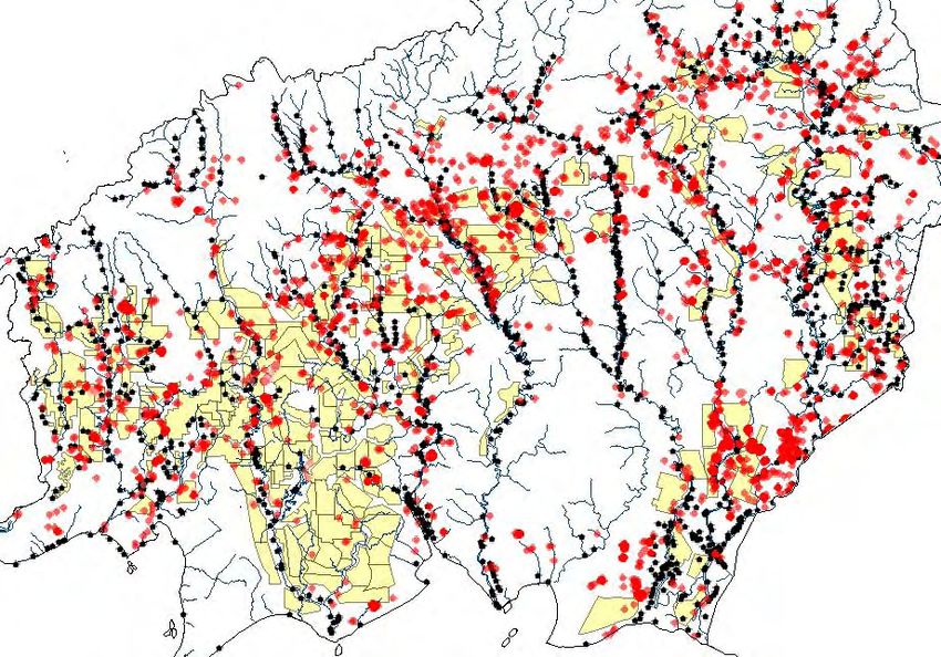
Executive Summary

2.5. Had caused social conflicts including land rights and resource conflicts through plantation
     expansion.

2.6. Had used the Roundtable on Sustainable Palm Oil (RSPO) membership rules by making
     two companies under GAR –SMART and PT Ivo Mas Tunggal – members of RSPO to
     “greenwash” and create an impression that GAR is committed to sustainability through
     RSPO membership.

3.   The IVEX Team Conclusions

In summary, the conclusions from the verification exercise with respect to the main points
made in the REPORTS are as follows:

3.1. Planting on peat lands and deep peat were found but not as extensively as claimed in
     the REPORTS. The planting on deep peat in concessions examined was mainly incidental
     due to the difficulty in identifying sporadic and small plots of deep peat. There is
     planting on deep peat (> 3 m) in two estates from 2005 – 2008 which is in breach of
     the Presidential Decree with regards to deep peat issued in 1990. This also contravened
     SMART’s own operating instructions.

3.2. All the land in the eleven concessions examined comprised of secondary forests, degraded
     and shrub land and were no longer primary forests before SMART started land clearing and
     planting. This was verified by analysing historical land use, sighting of minutes of the process
     of compensation and also sampling of timber potential of existing trees. It was confirmed by
     analysis of satellite photographs covering the areas before and after the land was acquired
     by SMART for oil palm cultivation. This suggests that the degradation process of forest areas
     that were habitats for Bornean Orang-utan happened before SMART took over the lands.
     While the above findings indicate that it is highly unlikely that there are High Conservation
     Value (HCV) forests left in the concession areas in Central and West Kalimantan, 21%
     (37,698 Ha) of the total 182,528 Ha was opened before independent HCV assessment.
     This potentially contravenes RSPO Principles and Criteria (P&Cs) and SMART would need
     to propose a compensation or exclusion process when these plantations enter into the
     certification process.

3.3. A thorough analysis of the three concessions in Kapuas Hulu, West Kalimantan, showed
     that there was no potential of economically valuable timber. Consequently, SMART did
     not continue to process its IPK application.
     In West Kalimantan, all except two concessions examined had the necessary EIA (AMDAL)
     prior to land clearance activities. In these two cases, the local government, District Head
     of Ketapang (Bupati) allowed land clearing before EIA approval for all oil palm plantation
     concessions in its district.
     In Central Kalimantan, all concessions examined were found to have carried out land
     clearance before the EIA was approved. SMART explained that they had interpreted the
     Ministry of Agriculture Regulation No. 229/Kpts/KB.550/4/91 date 25 April 1991 and
     753/Kpts/KB.550/12/93 date 6 December 1993 that a plantation company can develop
     the plantation before EIA. SMART also interpreted Ministry of Agriculture Regulation No.
     786/Kpts/KB.120/10/96 date 22 October 1996 that a plantation company can develop
     the plantation simultaneously while EIA and HGU (Land Use Title) being processed before
     the company obtains a permanent plantation permit.

3.4. Field verification could not find evidence of burning in land clearing and preparation.
     SMART has a zero-burning policy for land preparation. Observations and analysis of
     hotspot data support the view that systematic land clearance by burning had not taken
     place. Most hotspots and burning in or near SMART’s concession occurred before land
     compensation and preparation and were likely to have been caused by traditional slash-
     and-burn practices of the local community.

4      BSI-CUC • Verifying Greenpeace Claims Case: SMART
Executive Summary

3.5. While the team found no evidence of negative social impact from the planting of oil palm in the
     concessions, it has noted weaknesses in SMART’s documentation of its engagement process
     with land owners during the land compensation dialogue. Interviews conducted in the field
     with members of the community indicate they perceive the plantations had a positive impact.
     However, The IVEX Team feels that for its observations to be conclusive, separate research
     needs to be done and recommends that SMART embarks on this.

3.6. A literal reading of the RSPO Certification Systems document Para 4.2.4, would indicate that
     RSPO rules allow SMART and PT Ivo Mas Tunggal and all operating units held by the two
     companies to embark on the RSPO certification process. However, it would appear that the
     literal reading may not sufficiently address organisations with complex legal and management
     structures who may use this loophole to ”greenwash”. In GAR’s case, it is clear that GAR is
     not a RSPO member and therefore it cannot claim or give the impression that GAR and all its
     subsidiaries are in the process of obtaining RSPO certification.

4.   Methodology

The methods used to verify the claims were:

4.1. Chronological tracing of the application and approval of the relevant licences;

4.2. Analysis of land-use history and development of land cover of the prospective concession
     areas, including the use of satellite images;

4.3. Reviewing the chronology of field activities from land survey and assessment, socializations,
     land acquisition, land preparation to planting;

4.4. Analysis of peat depth distribution map and re-measurement of peat depth through
     sampling by using a special drill for identification of peat depth and soil analysis;

4.5. Analysis of the overlap between the 2006-2007 hotspots distribution map (2008-2009
     for Kapuas Hulu) with maps of land acquisition development process;

4.6. Estimation of the timber potential of forested area through vegetation analysis with plots
     established through sampling;

4.7. Observations of wildlife populations in forested areas using tract and point combination
     method;

4.8. Interviews or consultation with the Heads of relevant Provincial Services (Forestry,
     Plantations and the Environment Agency), Head of Sentarum National Park and local
     government leaders (Regency Head and Related Regional Services) and other relevant
     people;

4.9. Literature analysis on relevant and existing regulations and legislations, reference books,
     reports and research results and EIA were conducted;

4.10. Field audits against RSPO Principles and Criteria which relate to the claims being
      verified;

4.11. Review of RSPO Rules particularly in relation to organisations with multiple companies and how
      this affects the RSPO certification process.

                                              Verifying Greenpeace Claims Case: SMART • BSI-CUC   5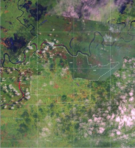
Executive Summary

5.    Findings

5.1. Peat
      5.1.1. Central Kalimantan
      •       Peat depth distribution maps compiled by SMART in six concessions areas located
              in Central Kalimantan Province was cross-checked/re-measured with 1% intensity
              sampling and indicated that of the total 90,278 Ha concession area (where the planted
              area was 57,746 Ha) there were peat lands with various depths totalling to 6,594 Ha
              (7.30%). Out of this 1,880 Ha (2.08 % of the total concession area) was deep peat of
              more than 3 meters, which were cleared and planted with oil palm trees.
      •       The total peat land was therefore below the 8,067 (6,594) Ha as claimed in the REPORTS.
              The deep peat area of is also below the 6,597 (1,880) Ha as claimed in the REPORTS.
      •       Incidental planting was observed in all areas where deep peat occurs. The main
              reason for clearing and planting on deep peat was that they were not concentrated
              within one area but spread sporadically in various places and in small plots which
              are not easy to identify during the field survey.

     5.1.2. West Kalimantan
      •       In Ketapang, out of 2 concessions 33,300 Ha, the peat of varying depths is 1,531 Ha. Of
              these, the entire 836 Ha (2.51%) of peat more t n 3 meters deep had been cultivated
              by the people involved in a transmigration program (568 Ha), and by SMART total 268
              Ha (0.80%), 114 Ha for plasma and 154 Ha for nucleus scheme. As there are multiple
              stakeholders in this area, SMART has indicated it will consult them on practical remedial
              actions.
                  • In PT Agro Lestari Mandiri (ALM), Ketapang, The IVEX Team field findings concurred
                      with the REPORTS that SMART “continued to clear peatlands” on deep peat.
                      SMART has indicated that this went against its Operating Instructions. The
                      plantation manager has been suspended pending outcome of the verification
                      report and stopped any planting on peat.
      •       In Kapuas Hulu, out of the total concession 58,950 Ha, the peat of varying depths is
              1,399 Ha. Of these, all the 494 Ha (0.8%) of peat more than 3 meters deep had been
              cultivated by SMART.
                  • The preliminary High Conservation Value Forest (HCVF) assessment report for PT
                     Kartika Prima Cipta (KPC) done by Fauna and Flora International (FFI) at Kapuas
                     Hulu in March 2009 states that within KPC (19,200 Ha) there was a total of 7,225
                     Ha of peat lands (37% of the total concession area). However, in FFI’s subsequent
                     analysis with additional data from field activities conducted from 11 to 14 August
                     2009, this was changed to 4,241 Ha where peat area more than 3 meters deep
                     was 1,868 Ha (9.7% of the total concession area).
                  • SMART’s own survey identified a total peat area of approximately 1,500 Ha, out
                     of this 48 Ha (0,25% of the total concession area) of deep peat more than 3
                     meters, were cleared and planted with oil palm trees. Furthermore, The IVEX
                     Team discovered that some locations identified as deep peat by FFI were actually
                     mineral soil.
                  • SMART agreed that for deep peat cultivated in KPC, it will conduct restoration
                    and rehabilitation works as well as closing the drainage channel network on
                    the converted peat area with depth of more than 3 meters.
                  • In PT Paramitra Internusa Pratama (PIP), The IVEX Team found oil palm trees
                     were cultivated in 13.8 Ha of deep peat. This was against SMART’s Operating
                     Instructions. SMART explained that an estate manager responsible has now been
                     suspended.

6         BSI-CUC • Verifying Greenpeace Claims Case: SMART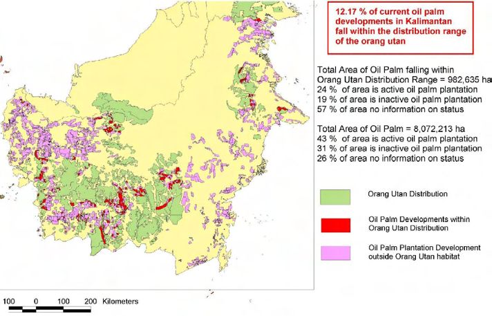
Executive Summary

5.2. Orang-utan and Forest Clearance

•   Analysis of historical land use, records of the minutes of the process for compensation
    and also sampling results of timber potential in forested areas, showed that the
    conditions of land cover throughout all eleven concession areas during the time when
    it was first managed by SMART in Central and West Kalimantan Province were no
    longer Primary Forest (Virgin Forest) as envisioned in the REPORTS. EIA study and HCVF
    assessment conducted in various concessions stated explicitly that the majority of the
    concession areas were degraded land or shrub areas. This is confirmed by satellite
    image analysis.

•   This suggests that the degradation process of forest areas that were habitats for Bornean
    Orang-utan happened before SMART took over the lands. In addition, the status of the entire
    concession areas according to the Central Kalimantan Provincial Spatial Planning (RTRWP)
    was designated for APL (non forestry cultivation land including settlement, industrial and
    urban areas). Thus, from the review status of the area, development of oil palm plantation
    by SMART was not a process of forest area reduction (which according to FAO is known as
    Deforestation).

•   RSPO Principles and Criteria require that areas with protected, rare, threatened or endangered
    species and HCV habitat are identified and recorded prior to planting and measures taken to
    preserve them. The typical interpretation is that these HCV assessments be done by external
    and independent experts. In the concessions examined, 21% (37,698 Ha) of the total 182,528
    Ha was opened before HCV assessment.

•   Based on the above interpretation and applying guidelines on when these criteria come
    into effect, 7 out of the 11 concessions (4 out of 5 in West Kalimantan and 3 out
    of 6 in Central Kalimantan) contravene RSPO P & C regarding HCV as planting was
    done prior to independent HCV assessment after November 2007. In 3 out of the 11
    concessions, planting was done between November 2005 and November 2007 which
    means that these could still enter the RSPO certification process provided an HCV
    compensation mechanism be proposed and accepted by RSPO.

•   The view of SMART is that since there were very few HCV assessors in Indonesia earlier,
    it used the information gathered from the independent EIA or AMDAL as guidance to
    identify HCV and hence minimizing the risk of developing on HCV. The RSPO National
    Interpretation directly links identification of HCV(F) to the EIA. However, the ambiguity
    over the similarities and differences between EIA and HCV(F) are not addressed by
    the RSPO. Therefore The IVEX Team recommends that the RSPO clarifies whether an
    independent (external) HCV assesstment is the only accepted means or whether other
    means of identify and recording HCV - using the EIA for example - is acceptable under
    the RSPO Principles and Criteria and the Indonesian National Interpretation.

•   Specifically in PT Buana Adhitama (BAT) there were no tree cover since 1999. SMART developed
    BAT from end 2006. Furthermore an independent HCV assessor by RSPO confirmed in June
    2010, that there is no Orang-utan and the only HCV is the river riparian and hilly area which
    are being conserved by SMART.

                                            Verifying Greenpeace Claims Case: SMART • BSI-CUC   7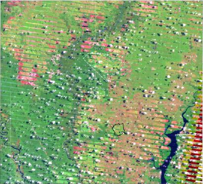
Executive Summary

5.3. Plantation and Timber Permits
    5.3.1. Timber Permits (IPK)
    Analysis was done involving:
    (a)     chronological analysis of acquiring the location permit;
    (b)     analysis of the historical use of the concession area prior to allocation to all
            eleven concessions;
    (c)     chronological analysis of the socialization activities, land acquisition/compensation,
            land preparation/land clearing; and
    (d)     using Landsat imagery interpretation to analyze the land cover data in the year
            preceding the compensation process.
    With reference to KPC, PIP and PT Persada Graha Mandiri (PGM), The IVEX Team findings
    showed that there was no potential of economically valuable timber with diameters more than
    30 cm. This was supported by field measurement and estimation of the potential economically
    valuable timber in areas where there is still some timber in the above three concessions. The
    IVEX Team found that timber with diameter more than 30 cm was only about 12.6 m3/Ha to 26.5
    m3/Ha (derived from 9 - 21 logs/Ha). This supports the reason that SMART did not continue to
    process IPK from the Kapuas Hulu Head of District when the Approval from Governor of West
    Kalimantan Province was obtained as the timber was not economically valuable.

    5.3.2. Plantation Permits
    •     Chronology of permit acquisition and scheduling of the implementation of field
          activities were reviewed.
    •     The IVEX Team found that all concessions in West Kalimantan had obtained the relevant
          permits before proceeding with field activities except for ALM and PT Kencana Graha
          Permai (KGP) in Ketapang which had commenced clearing and planting activities before
          the EIA (AMDAL) was approved.
    •     ALM and KGP, however, complied with the Decree No. 247 dated 12 September 2001
          issued by the Ketapang District Head. This decree stipulates the licensing procedure
          for large scale plantation business and states that the plantation business licence
          (IUP) can be obtained prior to the EIA approval. ALM and KGP commenced land-
          clearing prior to the completion of the EIA based on the Land-clearing Dispensation
          Permit issued by the Ketapang District Head.
    •     However, in Central Kalimantan The IVEX Team found that in all the six concessions
          examined, land clearing took place before the relevant permits (AMDAL) were obtained.
          This is in breach of Government Regulation 27/1999.
    •     SMART explained that they had interpreted the Ministry of Agriculture Regulation No. 229/
          Kpts/KB.550/4/91 date 25 April 1991 and 753/Kpts/KB.550/12/93 date 6 December
          1993 that a plantation company can develop the plantation before EIA. SMART also
          interpreted Ministry of Agriculture Regulation No. 786/Kpts/KB.120/10/96 date 22
          October 1996 that a plantation company can develop the plantation simultaneously
          while EIA and HGU (Land Use Title) are being processed before the company obtains a
          permanent plantation permit.

8       BSI-CUC • Verifying Greenpeace Claims Case: SMART
Executive Summary

5.4. Burning

    5.4.1. Central Kalimantan
        Table 5.1 Hotspot Verification
                                                                                       Percentage
         Location                                                       Hotspots
                                                                                           (%)
         Outside SMART’s Control
         Outside Concessions                                                69             42%
         Within Concessions Before Transfer Ownership                       38             23%
         Third Party Enclaves Within Concessions                            16             10%
         Sub Total                                                         123             75%
         Within SMART’s Control
         Border with Local Farmers                                          3              2%
         Within Concessions After Transfer Ownership                        25             15%
         Within Concessions After Planting                                  13             8%
         Sub Total                                                          41             25%
         Total                                                             164            100%

    •   From the data provided and the verification carried out during the visit, 164 hot spots were
        identified and of these, 75% (123) occurred outside SMART’s control and ownership,
        25% (41) hotspots occurred within SMART’s concessions. Of these, the cause of
        the 25 spots is unknown. SMART claims they often originate from slash and burn
        practices from neighbouring local farmers.
    •   Field verification could not find evidence of burning in land clearing and preparation.
        SMART has a zero-burning policy for land preparation. Observations and analysis of
        hotspot data support the view that systematic land clearance by burning had not taken
        place. Most hotspots and burning in or near SMART concession occurred before land
        compensation and preparation.
    •   Interviews and police reports indicated that all concessions have monitored fires and
        hotspots but non-compliance of procedures in documenting fires and hotspots was
        a weakness in most concessions.

    5.4.2. West Kalimantan
    Field verification could not find evidence of burning in land clearing and preparation.
    SMART has a zero-burning policy for land preparation. Most burning in or near SMART
    concession occurred before land compensation and preparation and were likely to have
    been caused by slash-and-burn practices of the local community.

                                             Verifying Greenpeace Claims Case: SMART • BSI-CUC    9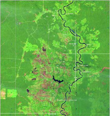
Executive Summary

5.5. Social Conflict
•    There was no evidence of conflict over land acquisition process. However, there was
     also no records of participatory discussions with previous land owners during the
     compensation process. There was no evidence that independent third parties were
     represented during discussions with land owners. Where there was evidence of meetings,
     it appeared that the attendees were SMART employees, land owners and sub district
     heads (Camat) who witnessed compensation payment rather than being involved in
     negotiations. There was no clear evidence that land owners were provided with a cost–
     benefit analysis to compare the merits of owning the land or relinquishing it. Some land
     owners who did not relinquish their land rights were interviewed and they indicated that
     there was no undue pressure from SMART to relinquish their land.
•    Interviews with the local community support the view that the plantations had a positive impact
     on the community. There were references of improvements in infrastructure and livelihood.
     However, the number of interviews conducted could not adequately conclude that there was
     no negative social impact to the communities. The IVEX Team feels that for its observations
     to be conclusive, separate research needs to be done and recommends that SMART embarks
     on this.

5.6. RSPO “Greenwash”
•    GAR has a total of 53 operating companies under its holdings which are involved in the
     ownership and cultivation of oil palm. Out of this, as of the date of this report, two are
     registered as members of RSPO. These are PT Ivo Mas Tunggal and SMART. From a
     review of the organisational structure of GAR, this means that a total of 51 companies
     involved in the ownership and cultivation of oil palm are not members of RSPO.
•    A literal reading of the RSPO Certification Systems document Para 4.2.4 would indicate
     that RSPO rules allow SMART and PT Ivo Mas Tunggal and companies held by these two
     companies to embark the RSPO certification process and be awarded certification if they
     meet the stated criteria and having passed the audit process. However, it would appear
     that the literal reading may not sufficiently address organisations with complex legal
     and management structures who may use this loop hole to ”greenwash” its operations.
     For example, in the case of GAR, SMART does not have legal control over all operating
     companies controlled by GAR but it manages all GAR’s palm oil operating units.
•    Our recommendation is that RSPO reviews this ruling and provides further clarity in
     cases where legal and management structures are complex. In the present case, what
     is clear is that GAR is not a member of the RSPO and therefore GAR cannot claim or
     give the impression that GAR (and therefore all the companies held by it) are in the
     process of obtaining RSPO certification.

10    BSI-CUC • Verifying Greenpeace Claims Case: SMART
Table of Contents
Executive Summary 3
1. Introduction 3
2. Greenpeace Claims 3
3. The IVEX Team Conclusions 4
4. Methodology 5
5. Findings 6
1. Background 13
1.1. Objectives of Verification 13
1.2. Contextualizing the key issues 13
1.3. Team Members and Qualifications 14
1.4. Methodology 17
1.5. Abbreviations 18
2. Literature Review 19
2.1. Deep Peat 19
2.2. Forests, Orang-utan Habitats and High Conservation Value (HCV) Areas 21
2.3. Permits 25
2.4. Land Clearance by Burning 27
2.5. Key Milestones 29
3. Field Verification 31
3.1. Clearance and Planting on Peat Lands 32
3.2. Forest Clearance, Orang-utan Habitats and HCV 40
3.3. Plantation and Timber Permits 55
3.4. Fire Prevention/Burning 62
3.5. Social Impacts 65
4. Conclusions & Evaluation 69
4.1. Peat lands 69
4.2. Forest Clearance, Orang-utans Habitats and HCV 70
4.3. Permits 71
4.4. Burning & Fire prevention 72
4.5. Social Impact 73
End Notes 75
Verifying Greenpeace Claims Case: SMART • BSI-CUC 1112 BSI-CUC • Verifying Greenpeace Claims Case: SMART
1. Background

1.1. Objectives of Verification

To review and verify the following Greenpeace reports (the REPORTS)
1.   Burning Up Borneo, April 2008 (“BUB”)
2.   Illegal Forest Clearance and RSPO Greenwash: Case Studies of Sinar Mas, December 2009
     (“RSPO Greenwash”)
3.   Caught Red Handed, March 2010
4.   New Evidence Sinar Mas Rainforest and Peatland Destruction, April 2010
5.   Powerpoint Presentation: Sinar Mas Continues Rainforest Destruction, April 2010

The verification exercise will aim to provide accurate, complete and contextual information to
assess the issues identified in the above reports and identify gaps, if any.
The issues raised in the above reports would be verified against the relevant parts of:
•    The prevailing laws and regulation in Republic of Indonesia.
•    The Indonesian National Interpretation of RSPO Principles and Criteria.

•    The Standard Operating Procedures of SMART.

1.2. Contextualizing the key issues

Since most of the issues raised in the REPORTS are complex, an important part of the
verification exercise was to assess these issues in context. Contextualizing includes

      1.2.1. Assessing relative as well as absolute occurrence of issues raised, for example
             the surface in absolute (ha) and relative (% of area/concession) of the area of
             development of peat, if found.

      1.2.2. Patterns of occurrence of issues raised, for example the pattern of peat area
             (sporadic, compact, zonal etc), comparing the average size of each peat area
             compared to the size of the concession.

      1.2.3. Recognizing the complexities of the Indonesian legal system, including the chronology
             of decrees, possible difference of interpretation between national laws and regional
             decrees and between decrees of different ministries.

      1.2.4. Assessing findings in the perspective of the capacity of prevailing tools commonly
             used and accepted in the industry, for example, soil studies conducted earlier
             using acceptable measurement tools under limited ground accessibility should be
             interpreted under those constraints and not discounted.

                                             Verifying Greenpeace Claims Case: SMART • BSI-CUC   13
Background
1.3. Team Members and Qualifications
To achieve the above objectives, the exercise assembled a multinational team of certifiers, auditors
and researchers. By doing this, The IVEX Team has attempted to combine domain expertise, under-
standing of local laws and context, academic and scientific rigour and structured audit discipline.
These have been applied to perform the verification exercise and produce the verification report.
For all Greenpeace claims on environmental issues, The IVEX Team extended its verification to ALL
the eleven concessions covered in the field visit. The field visits were conducted from 17 to 22 May
2010 and 31 May to 8 June 2010 in Central and West Kalimantan respectively.
All persons mentioned below have declared that they have no conflict of interest, i.e. any
consulting or purchasing, with the company or companies under assessment, their major
shareholders, or Greenpeace.
1.3.1. BSI Group
Founded in 1901 as the Engineering Standards Committee, BSI Group is now a leading
global independent business services organization providing standards-based solutions
in more than 140 countries. BSI
• develops private, national and international standards
• certifies management systems and products
• provides testing and certification of products and services
• provides training and information on standards and international trade and
• provides performance management and supply chain management software
solutions
BSI was one of the first Certification Bodies approved by RSPO to do RSPO certification
audits.
Allan Thomas holds a tertiary qualification in commerce and accounting from Wollongong
University in 1973 and has more than 18 years experience in systems management and
auditing of large organisations in construction, forestry, agriculture, manufacturing and in
private and Government sectors both in Australia, South East Asia and the South Pacific.
He has performed over 100 comprehensive audits of management systems throughout
the Palm Oil industry including Occupational Health and Safety, Environmental and
Quality Management Systems. He has also advised companies on the implementation
of OHS in the Oil Palm Industry. He has worked in Indonesia, Malaysia and Solomon
Island (SI) in the Oil Palm industry. He has worked closely with RSPO in developing an
audit checklist for the Principles and Criteria and developed an audit methodology. He
also performed the first base line assessment of the applications of the P&C. He is a
strong advocate of environmental, safety and social accountability
Allan is also Lead Environmental Auditor (ISO 14001) with IRCA, A Lead OHS Auditor
(OHSAS 18001 & AS 4801) with IRCA, a Lead Quality Auditor (ISO 9001:2008) with
RABQSA and also an accredited Heavy Vehicle Auditor. He has also implemented
strategies for implementing and maintaining SA 8000. Allan has also been appointed a
Federal Safety Officer by the Australian Commonwealth Government.
Dwi Rachmat Muhtaman holds a Masters Degree in Public Administration as well as a Degree
in Animal Husbandry, specialising in Social Economics. For the last more than 15 years, he
has been included as the social expert on several certification forest audits/assessments for
both plantation and natural forest concessions in Kalimantan, Sumatera, Sulawesi and Java.
He has been involved in more than 30 forest and product certification assessments since
1996-2007 in more than 25 forest management concessions. For the last five years, Dwi has
been participating in variety of oil palm plantation assessment for IFC (International Finance
Corporation) Performance Standards, RSPO standards and HCV identification and Social
14 BSI-CUC • Verifying Greenpeace Claims Case: SMARTBackground
Impact Assessment (SIA), and Café Practices verification program (Indonesia and Papua New
Guinea). He has been working with more than 25 companies of the major oil palm companies
including Lonsum Group, Wilmar Plantation International Group, Musim Mas Group, IOI Group.
He has been involved in RSPO audit in Johor, Sabah, Sarawak (Malaysia) and Indonesia. He
has a good network among NGO communities and forest private sectors. He is auditor for
chain of custody assessment of forest product industries in more than 20 wood industries. He
is also an independent consultant for WWF Indonesia PFTN/Nusa Hijau for wood industries
and forest management units.
Iman Nawireja has combination of a BSc in Agriculture and Resource Economics from
one of the most reputable universities in Indonesia, further Master in Communication,
and now pursuing Doctoral degree in Rural Sociology provides extensive and multi-
disciplinary capabilities. He is also member of RSPO Indonesian Smallholders Working
Group (INA SWG). He has assisted with field studies on socio-economic aspect of
agriculture, effect of resources development projects on farmer and community welfare,
health status, and social change, environmental and social assessments of 8 oil palm
projects (total of 102 consulting days) during the past 6 years. He has assisted with
conducting audits of oil palm plantation companies against the RSPO P&C in Indonesia
and Malaysia.
Tom Diwai Vigus holds a BSc Forestry (Hons) in Forestry, graduating from the University
of Wales (Bangor) in 1970. He has 40 years practical and teaching experience in the
areas of tropical forestry, environment, conservation and socio-economics of logging
and agricultural development in the Pacific Islands, particularly Papua New Guinea (PNG)
and the Solomon Islands. His key research field is the effects of industrial logging on
the ecology of tropical rainforests and during his research from 1981, whilst a Senior
Lecturer at the University of Technology in Lae, PNG, to 1995, whilst working on an
AusAID project he developed a technique he coined “Reforestation Naturally” to enhance
the speed of regeneration of heavily logged forests collaborating with local villagers;
this has been endorsed by the PNG Forest Authority as one of their major thrusts to
establish sustainable logging. In April 2003, he was engaged by the PNG government
as Field Team leader/Professional Forester in the most extensive field and desktop
audit ever undertaken of existing large scale logging operations in PNG, the Independent
Review of Existing Logging Projects, completing 14 in depth reports and contributing to
the final report which contained recommendations for all stakeholders to move towards
sustainability in the PNG Forestry Sector.
1.3.2. Control Union Certifications
Control Union Certifications (CUC) is a member of the Control Union World Group - an
international inspection and certification body. Control Union (CU) performs certification
assessments in many agricultural based fields such as FSC, RSPO, SCCS, Organic
Production, Sustainable Textile Production, Organic Exchange, Eurepgap/GlobalGAP,
HACCP, BRC, GMP and GTP. CUC is accredited by the Dutch Council of Accreditation
(RVA) on the European Quality Standard EN 45011 for the inspection and certification
of CU Organic program (according to the EU regulation 2092/91) and GLOBALGAP
program.
Verifying Greenpeace Claims Case: SMART • BSI-CUC 15Background
David Ogg has prepared and implemented the systems for Control Union Certifications
for the auditing, evaluation and awarding of RSPO certificates to palm oil mills and their
supply base and for the RSPO Supply Chain Certification Systems. He has developed
training manuals and presentations for palm oil growers and processors and has trained
the auditing teams. David has carried out audits covering in excess of one million ha of
oil palm, including group schemes. Audits of at least 100 palm oil mills and downstream
processes such as refineries, bio-facilities, diesel plants and storage. Coordinator and
principle technical expert for the development of components of the RTRS Principles and
Criteria Certification system and RTRS field test support program. Prior to joining CUC
in August 2006, David set up and managed the largest group schemes in the world for
forest management and chain of custody in accordance with the Forest Stewardship
Council rules and became a fully accredited certification body in his own right. He is a
Fellow of the Institute of Chartered Foresters.
Senniah Appalasamy holds MBA in Human Resource Management and BSc in Resource
Economics majoring in Agriculture Resource Management from Agriculture University of
Malaysia. He has extensive experience in the palm oil industry and has been involved in
plantation management for more than 10 years. He was a Quality Assurance Manager in
food and beverage industry for 10 years. During these 20 years, he has been vastly involved
in the implementation of Environment and Quality Management System, Food Safety and
Occupational Safety & Health. He has been trained and qualified as ISO 9001:2008 Lead
Auditor. For the past two years, he has been involved in certification assessments and
verifications with various standards, which includes RSPO P&C, RSPO SCCS, GMP B2 and
GLOBALGAP (Fruit, Vegetable and Aquaculture). Senniah Appalasamy has conducted over 50
system audits and verification assessments for the past two years.
1.3.3. Expert from Faculty of Forestry, Bogor Agricultural Institute (IPB)
Bambang H. Saharjo is a leading expert in the field of forest protection and fire
ecology. He has worked with various organizations as a forest fire expert. He was
the WWF-Indonesia Forest Fire Expert in 1999 and was also a team member for the
Indonesian Government Regulation in 2001. Prof. Saharjo is a prolific researcher and
has written numerous publications focusing on fire ecology, forest fire prevention, fire
impact and environmental destruction due to illegal logging. Prof. Saharjo holds a PhD
in Forestry from Kyoto University in Japan.
Yanto Santosa has over 25 years of experience in the area of agricultural and forestry.
He currently holds several top teaching positions at IPB (Bogor Agriculture Institute),
the internationally recognized state university focused on tropical agriculture and life
science. He was the Director of Tropical Biodiversity Research Centre of IPB and also
the Head of the Indonesian Wildlife Preservation Communities. Dr. Santosa has written
several publications on biodiversity and forest conservation. He also held position as
the Education and Cultural Attaché of the Indonesian Embassy in France between 1999
and 2004, led the steering committee for the Biodiversity Conservation Program between
Indonesia and Malaysia during 1997 to 1999 and was a guest lecturer at two French
universities, Universite de Bordeaux III and Universite d’Aix-Marseille III until 2004. Dr.
Santosa holds a PhD from Universite Paul Sabatier (Toulouse III) in France.
16 BSI-CUC • Verifying Greenpeace Claims Case: SMARTBackground
1.4. Methodology
The methodology used in assessing the issues identified in the REPORTS, is outlined below.
1.4.1. Chronological tracing of the application and approval of the relevant licences;
1.4.2. Historical analysis of land use and land cover in all of concession areas. The analysis
was targeted to identify previous activities carried out in areas covered in SMART
estates. Information on history of land cover is very important to understand land cover
conditions before it was acquired and compensated by SMART which further converted
into oil palm plantation;
1.4.3. Chronological assessment of field activities since land release compensation, land
preparation and planting. Assessment was aimed to get clarity upon the time
frame and work volume that has been conducted and will be completed especially
work related to land release compensation, land preparation and planting;
1.4.4. Analysis of peat depth distribution map and re-measurement of peat depth
through sampling by using a special drill for identification of peat depth; and soil
analysis;
1.4.5. Analysis of the overlap between the 2006-2007 hotspots distribution map (2008-
2009 for Kapuas Hulu) with maps of land acquisition development process;
1.4.6. Estimation of the timber potential of forested area through vegetation analysis with plots
established through sampling;
1.4.7. Observation of wild-life in forested area or conservation area by combination of tract
and point method (along 1-2 km of observation path) in conservation area of PT
Binasawit Abadipratama (BAP), KPC, and PIP to understand the presence of Orang-utan
and other biodiversity;
1.4.8. Interviews or consultation with related the head of provincial services, e.g. Forestry
Department, Agriculture Department and Environment Agency, head of National
Park and related local government leaders (Bupati and other department at
district level) and local community representatives;
1.4.9. Literature review to relevant and applicable laws/regulations, text books, research
reports and/or SEIA documents in order to have rigorous theoretical foundations
and regulations related to claims to be verified;
1.4.10. Field audits against RSPO Principles and Criteria which relate to the claims being
verified;
1.4.11. Review of RSPO Rules particularly in relation to organisations with multiple
companies and how this affects the RSPO certification process.
Verifying Greenpeace Claims Case: SMART • BSI-CUC 17Background
1.5. Abbreviations
AMDAL Analisis Mengenai Dampak Lingkungan – see EIA
ANDAL Analisis Dampak Lingkungan – Environmental Impact Asessment
BRC British Retail Consortium
BSI British Standards Institution
COC Chain of Custody
CU Control Union
CUC Control Union Certification
Dokumen Pengelolaan dan Pemantauan Lingkungan Hidup – Environment Management and
DPPL
Monitoring Document
EIA Enviromental Impact Assesment
EU European Union
EUREPGAP Euro-Retailer Produce Good Agricultural Practices
FAO Food & Agriculture Organization
FSC Forest Stewardship Council
FSC FM Forest Stewardship Council Forest Management
GlobalGAP Global Good Agricultural Practices
GMP Good Manufacturing Practice
GTP Good Trading Practice
GOTS Global Organic Textile Standard
HACCP Hazard Analysis and Critical Control Point
HGB Hak Guna Bangunan (Building Use Title)
HGU Hak Guna Usaha (Land Use Title)
IPB Institut Pertanian Bogor – Bogor Agricultural Institute
IPK Ijin Pemanfaatan Kayu (Timber Utilization Permit)
ISO International Organisation for Standardization
IUP Ijin Usaha Perkebunan (Plantation Business Permit)
IUPHHK Ijin Usaha Pengusahaan Hasil Hutan Kayu
IUCN International Union for Conservation of Nature
OE Organic Exchange
OSH Occupational Safety and Health
OSHAS Occupational Safety and Health Assessment Scheme
P&C Principles and Criteria
PEFC Programme for the Endorsement of Forest Certification
RPL Rencana Pemantauan Lingkungan Hidup – Environmental Monitoring Plan
RKL Rencana Pengelolaan Lingkungan Hidup – Environmental Management Plan
RSPO Roundtable on Sustainable Palm Oil
RSPO NI Roundtable on Sustainable Palm Oil National Interpretation
RSPO P&C Roundtable on Sustainable Palm Oil Principle & Criteria
SA8000 Social Accountability 8000
SEMDAL Studi Mengenai Dampak Lingkungan Hidup
SCCS Supply Chain Certification System
SEL Studi Evaluasi Lingkungan (Environmental Evaluation Study)
SIA Social Impact Assessment
SOP Standard Operating Procedures
UKL Upaya Pengelolaan Lingkungan – Environmental Management Effort
UNFCC United Nations For Climate Change
UNEP United Nations Environmental Program
UPL Upaya Pemantauan Lingkungan – Environmental Monitoring Effort
USDA United States Department of Agriculture
WHO World Health Organization
WWF Worldwide Fund for Nature
18 BSI-CUC • Verifying Greenpeace Claims Case: SMART2. Literature Review
The REPORTS raise concerns related to six issues:
1. Planting in peat and deep peat
2. Deforestation, destruction of Orang-utan habitat and High Conservation Value areas
3. Clearing forest land and/or logging without permits
4. Clearing land by burning
5. Causing social conflicts
6. Greenwashing using RSPO membership
For relevant issues, this chapter sketches the context, background and legal requirements,
based on independent, scientific literature and observations from experts. In addition, the
literature review identifies relevant RSPO requirements as a reference for best management
practices. In particular, it included the RSPO National Interpretation, which is drafted by a
multi-stakeholder working group, field-tested, consulted publicly, and endorsed by the RSPO1.
Where the current legal requirements are more precise, the RSPO requirements are adapted
to include the legal requirements.
Based on the literature review, it then identifies key verifiers that balance legal requirements
and best management practices to facilitate field verification and reporting.
2.1. Deep Peat
Of the tropical peat land forests, the majority are situated in Indonesia. By and large, peat
lands are found in Sumatra, Kalimantan and West Papua. Undisturbed, primary peat swamp
forests sequester carbon through accumulation in peat and biomass. Drainage and degradation
of peat forests result in carbon emissions, mainly through increased decomposition of the
peat. In general, deeper drainage depth causes higher CO2 emissions. However, the exact
impacts of drainage on decomposition – and hence CO2 emissions – are under dispute2.
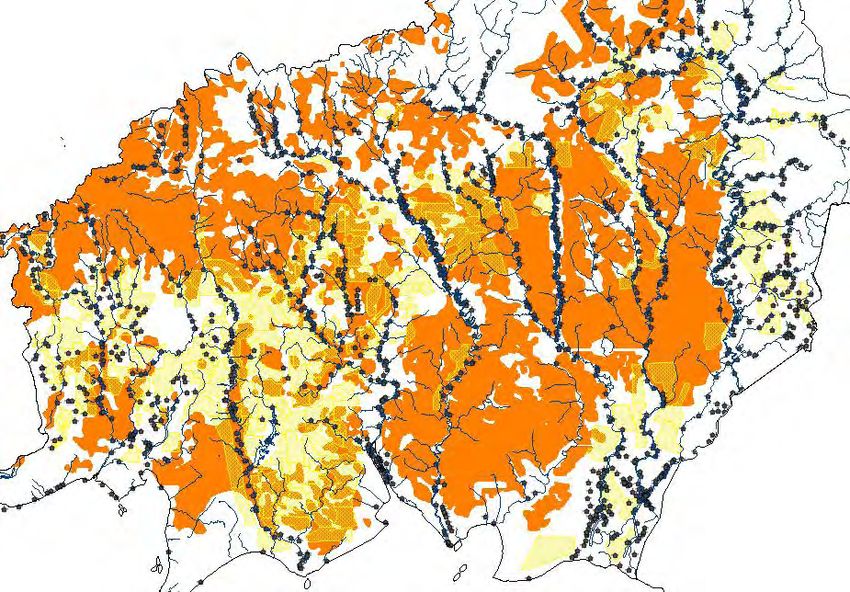
Image 2.1 Peat distribution in Central Kalimantan: relative few oil palm plantations
(yellow) are situated on peat lands (black); data on plantations and peat
courtesy of Greenpeace.
Verifying Greenpeace Claims Case: SMART • BSI-CUC 19Literature Review
With regards to legislation on (deep) peat, the REPORTS refer to Presidential Decree 32/1990,
Minister of Forestry and Plantation Decree 376/1998, and Minister of Agriculture Decree
14/2009. Other relevant legislation include:
• Presidential Decree 32/19903 regulates the identification of ‘protection areas’. It requires
that these areas – with the purpose to protect the environment – are identified/gazetted
(Article 1, Point 1) by the provincial government. These areas are to be gazetted through a
provincial decree (Peraturan Daerah Tingkat I), including a map (minimum scale 1:250.000)
and an exposition (Article 34, Point 1), within two years after this decree (Article 40, Point
1). Article 10 defines the criteria to gazette upland ‘peat area’ as ‘Protection Areas’, with
the purpose to support downstream areas (Article 4).
• Minister of Forestry and Plantation Decree 376/19984 .This ministerial decree states that
“…. State Forest Land with deep peat (2 m or more) is considered not suitable for oil
palm.”
• Government Decree 26/2008 “…. identifies ‘Protection Areas’ (Article 52), including ‘peat
area’ defined as “peat with 3 meters depth or more, located upstream (of river) and
swamp area” (Article 55), Guidance (Article 97).”
• Minister of Agriculture Decree 14/20095 reconfirms Presidential Degree 32/1990, and sets
strict regulations for the use of peat lands in plantations.
An additional piece of legislation for Central Kalimantan:
Presidential Decree 80/1999, (article 1) on peat in Central Kalimantan (unofficial translation
as follow):
(3) Land on the shallow peat area with the depth less than 3 meters on the peat
development working area can be used for forestry, agriculture, fishery and
plantation cultivation, the development and management of those mentioned
will be functionally operated under Central Kalimantan Provincial Governor.
(4) The area with peat wet land with the depth more than 3 (three) meters and
the area for conservation at the peat development working area will be used
for conservation that the management will be conducted by Forestry and
Plantation Department.
The RSPO National Interpretation is less rigorous than the legislation, and only requires that
peat lands are identified, mapped and managed with care6. The RSPO Certification Systems
contains no specific requirements for peat.
Verifiers related to this issue:
Verifier Description
PEAT1 Peat lands are identified, inventoried and mapped
Land preparation only occurs on mineral soil or shallow peat with a
PEAT2
substrata of clay without pyrite/quartz sand
PEAT3 A documented water management programme for peat lands is in place
20 BSI-CUC • Verifying Greenpeace Claims Case: SMARTLiterature Review
2.2. Forests, Orang-utan Habitats and High Conservation Value (HCV) Ar-
eas
2.2.1. High Conservation Value Forests (HCVF)
HCVF is a concept that aims to maintain and enhance extraordinary and exceptional
forests for reasons of biodiversity and livelihoods. HCVF emerged around 1992 and
was formally introduced by the Forest Stewardship Council in 1999. The RSPO included
HCVF in 2005. Albeit rather abstract, there’s international agreement over six attributes
of HCVF (see text box 2.1 & 2.2).
Both FSC and RSPO initially provided little guidance on the concept. Independent
initiatives on HCV(F) emerged and proliferated, with guidelines and toolkits by ProForest,
the HCV Resource Network, the Rainforest Alliance, The Nature Conservancy and the
Box 2.1. HCV Definitions (FSC, HCV Network & RSPO)
HCV1: Forest areas containing globally, regionally or nationally significant concentra-
tions of biodiversity value (e.g. endemism, endangered species).
HCV2: Forest areas containing globally, regionally or nationally significant large
landscape level forests, contained within, or containing the management unit,
where viable populations of most if not all naturally occurring species exist in
natural patterns of distribution and abundance.
HCV3: Forest areas that are in or contain rare, threatened or endangered ecosys-
tems.
HCV4: Forest areas that provide basic services of nature in critical situations (e.g.
watershed protection, erosion control).
HCV5: Forest areas fundamental to meeting basic needs of local communities (e.g.
subsistence, health).
HCV6: Forest areas critical to local communities’ traditional cultural identity (areas
of cultural, ecological, economic or religious significance identified in coopera-
tion with such local communities).
Box 2.2. HCV Definitions (National Toolkit)
HCV1: Areas with Important Levels of Biodiversity
HCV2: Natural Landscapes & Dynamics
HCV3: Rare or Endangered Ecosystems
HCV4: Environmental Services
HCV5: Natural Areas Important for Meeting the Basic Needs of Local People
HCV6: Areas Important for Maintaining the Cultural Identity of Local Communities
World Wide Fund for Nature.
In Indonesia, HCVF is dynamic and ambiguous, with varying results. HCV(F) assessments
have been performed on many management units, but few results are publicly available.
A brief history illustrates this dynamic and ambiguity:
• In January 1999, FSC formally adopts HCVF as Principle nine7, with the purpose to
maintain and enhance extraordinary and exceptional (natural) forests for reasons of
biodiversity and livelihoods. It defines six different social and environmental attributes
of high conservation values (see text box 2.1. and 2.2.).
• In August 2003, The first HCVF Toolkit for Indonesia8 is released. This toolkit is
limited to ‘forests’ and uses attributes similar to those identified by the FSC.
Verifying Greenpeace Claims Case: SMART • BSI-CUC 21Literature Review
• In November 2004, the RSPO formally adopts HCV (Habitats) as Criterion 5.2 and
Criterion 7.39, to protect remaining natural vegetation (including riparian areas, steep
slopes, forest fragments, conservation set-aside/reserve areas). The HCV attributes
defined are similar to those of the FSC.
• In September and November 2007, The final draft RSPO National Interpretation10 and
the RSPO National Interpretation11 directly link identification of HCV(F) to the EIA12.
The ambiguity over the similarities and differences between EIA and HCV(F) are not
publicly addressed by the RSPO.
• In May 2008, The final RSPO National Interpretation13 states:
• The HCV requires appropriate training and expertise, and must include consultation
with local communities, particularly for identifying social HCVs.
HCV conducted according to the National Interpretation of the HCV or according
to the Global HCV Toolkit if a National Interpretation is not available14.
• HCV is identified as a forest area that contains critical or outstanding environmental
and social values.
• In June 2008, a revised HCV Toolkit for Indonesia15 is released. This toolkit was approved
through extensive stakeholder consultation, and endorsed by the HCV Resources Network16
(but not yet by the RSPO). It revised (instead of interpreted, see bullet point May 2008)
the HCV attributes (see box 2.1 and box 2.2). This toolkit refers to HCV Areas, but is
ambiguous over the nature of these areas and defines HCV as something that has high
conservation value17. It furthermore went beyond forests and tried to include non-forest
areas containing high conservation values. The toolkit furthermore introduces (new)
models and GIS datasets to identify HCVF.
• In September 2009, the RSPO Indonesian Working Group presented the first draft
version of guideline on Management and Monitoring of High Conservation Value for
Sustainable Palm Oil Production in Indonesia.
• In March 2010, the RSPO approves the first dozen HCV Assessors. Effective now,
HCVF can now be assessed by personnel with ‘appropriate training and expertise’
(see bullet point May 2008), but human resources remain very limited.
The RSPO National Interpretation and the RSPO Certification Systems prohibit conversion of
HCVF after November 200518. The first further requires that oil palm managers identify, conserve,
monitor and evaluate HCVF. The HCVF Toolkit covers general methods to identify HCVF (such
as peat19, forest and Orang-utan), but contains no specific requirements regarding conservation
of thereof. Thus, it is the daunting task of the HCVF Assessments at the various sites to identify
HCVF and activities to conserve them.
The REPORTS are particularly concerned with Peat Forests20 and Orang-utan Habitat21.
These topics are further discussed below.
Verifiers related to this issue:
Verifier Description
HCVF1 HCVF are identified, inventoried and mapped
HCVF Assessments assure that no replacement of HCVF occurred after
HCVF2
November 2005
HCVF3 HCVF management programme is in place
Key species (Orang-utan) and habitats (peat forests) are monitored and
HCVF4
conserved
22 BSI-CUC • Verifying Greenpeace Claims Case: SMARTLiterature Review
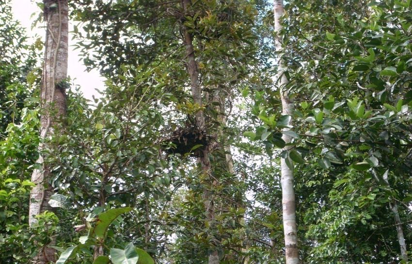
2.2.2. Orang-utan Habitat
Orang-utan occur in a broad range of habitat, from swamp forests and lowland
dipterocarp forests to upland forests up to some 1800 m above sea level22. It appears to
easily adapt to disturbances and can well survive in degraded forests23. It is an omnivore
that lives on leaves, buds, insects, flowers, eggs, small vertebrates (gecko, squirrel, small
sloth), epyphytes, and lianas. Most time they spent feeding in fruit trees of 20 – 30
meters high24. However, they prefer forests with big trees (35–50 meters high) to build
nests, and little ground cover25.
Two main populations Orang-utan remain, in Borneo and Northern Sumatera. Population
estimates of the Borneo Orang-utan varied strongly, between 1,00026 and 160,00027 individuals.
The most recent estimates lie around 60,00028 individuals. The majority of these Orang-
utan are found spread throughout areas north of the Kapuas River (West Kalimantan and
Sarawak).
Population estimates of Orang-utan in Central Kalimantan are not available. However, a
population and habitat viability model suggest the Orang-utan may have widely ranged in
2002. (The data behind the Kalimantan Orang-utan distribution map comes from: Meijaard,
E. & Dennis, R.A. (2003) Assessment of the extent of the remaining habitat for Borneon
Orang-utan, based on 2002 forest cover data. Internal Report, February 2003. (2002 forest/
non-forest classification kindly provided by Doug Fuller of George Washington University, in
association with The Nature Conservancy; Prior to the 2002 fires).
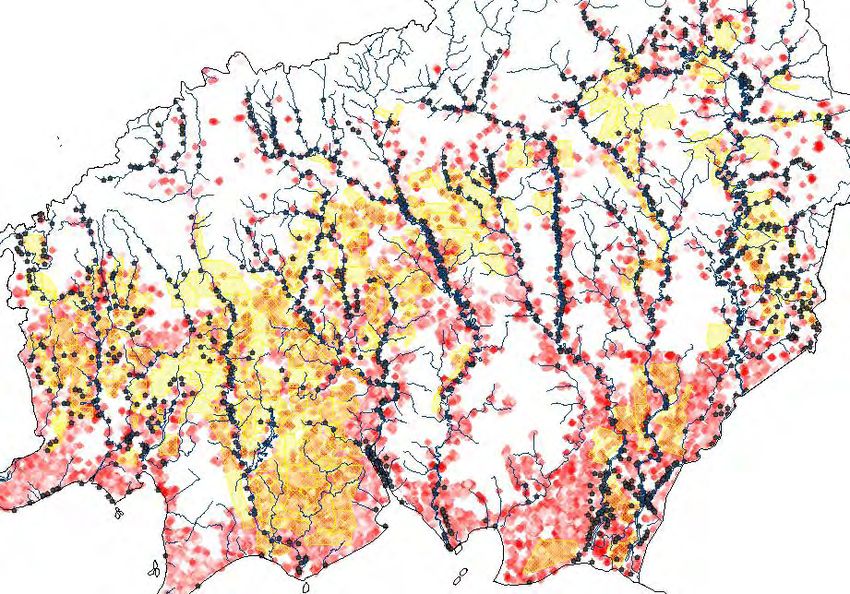
Image 2.2. Possible Orang-utan habitat (2002) in Central Kalimantan: possible
Orang-utan habitat (orange) shows weak relation to oil palm plantations
(yellow); data on plantations and Orang-utan courtesy of Greenpeace, data
on forest cover courtesy of Badan Planologi, Tropenbos and WWF.
Verifying Greenpeace Claims Case: SMART • BSI-CUC 23Literature Review
Image 2.3 Overlap of Orang-utan distribution and oil palm boundaries for Indonesian
Borneo29 (Meijaard 2009)
Key threats to the Orang-utan are deforestation and hunting (for food and trade). Changes in
forest area function into APL (other utilization area) conduct without referring to applicable law
and regulation hugely impacted on Orang-utan population and habitat decrease.
Two pieces of legislation protect the Orang-utan in Indonesia: Law 5/1990 and Government
Regulation 7/1999 stipulate the protection of wildlife habitat, populations and individual
animals, regardless of where they are located in Indonesia (i.e. in protected areas and outside,
including in homes, gardens and estates). They strictly prohibit catching, injuring, keeping,
transporting and trading Orang-utan (parts).
Neither the RSPO National Interpretation, nor the RSPO Certification Systems contains
requirements specific to the conservation of Orang-utan (other than HCVF).
Verifiers related to this issue:
Verifier Description
HCV1 HCV are identified, inventoried and mapped
HCV Assessments assure that no replacement of HCVF occurred after
HCV2
November 2005
HCV3 HCV management programme is in place
Key species (Orang-utan) and habitats (peat forests) are monitored and
HCV4
conserved
24 BSI-CUC • Verifying Greenpeace Claims Case: SMARTYou can also read