An Open Access Index for the Geographical Distribution of the Cuneiform Corpus
←
→
Page content transcription
If your browser does not render page correctly, please read the page content below
Cuneiform Digital Library Journal 2021:1

© Cuneiform Digital Library Initiative
ISSN 1540-8779
Version: 19 July 2021

             An Open Access Index for the Geographical
               Distribution of the Cuneiform Corpus
           Rune Rattenborg                 Carolin Johansson                  Seraina Nett
          University of Uppsala           University of Uppsala            University of Uppsala
                        Gustav Ryberg Smidt                   Jakob Andersson
                        University of Uppsala                University of Uppsala

§1. Introduction1                                       has brought with it a more pressing need for
                                                        global, standardised indices for accessing, query-
We present here the first comprehensive version ing, and analysing the immense amount of digi-
of the Cuneiform Inscriptions Geographical Site tal data now available. By fielding a comprehen-
Index, an open access digital index which in- sive spatial index of finds of cuneiform inscrip-
cludes standardised locational and attribute infor- tions, we hope to motivate usage of a standard
mation for more than 500 archaeological locales index for naming and referring to archaeologi-
from across the Eastern Mediterranean and the cal proveniences, further integrated approaches
Middle East where texts written in different va- to the study of this corpus in its entirety, and
rieties of the cuneiform script have been found.2 to make its contents more immediately available
This resource is derived from the research pro- for researchers from other fields. In the follow-
grammes of the Memories For Life and the Ge- ing sections, we briefly sketch the relevance and
omapping Landscapes of Writing3 projects of the Up- potential application of this resource, the struc-
psala University Department of Linguistics and ture and contents of the assembled dataset, direc-
Philology, financed respectively by the Swedish tions for its integration with existing catalogues
Research Council (grant no. 2016-02028) and the and its potential application in future research.
Riksbankens Jubileumsfond (grant no. MXM19- Regular updates of the dataset are released in
1160:1). Through the application of a corpus- .csv, .geojson, and .kml formats under a Cre-
wide perspective on the cuneiform script, these ative Commons Attribution 4.0 International Li-
projects are advancing the application of digital cense4 from Uppsala University Department of
humanities research design to the study of writ- Linguistics and Philology and hosted by Lecturer
ing in the ancient world, set at the interface of text, in Assyriology Jakob Andersson of the same in-
materiality, and open access data repositories. stitution.5 A stable version of all releases is de-
The rapid growth of digital repositories and ap- posited with the OpenAIRE repository Zenodo
plications in cuneiform studies of recent decades (http://doi.org/10.5281/zenodo.4960710).

1
    Funding: Swedish Research Council grant no. 2016-02028 and Riksbankens Jubileumsfond grant no. MXM19-
    1160:1 (see https://www.vr.se/english/swecris for details)
2
    We would like to express our sincere gratitude to the editors of the CDLJ and the two anonymous reviewers
    for their comments and suggestions to this paper. We should furthermore acknowledge the expert insight and
    advice of several colleagues, namely Émilie Pagé-Perron, Nathan Morello, Jamie Novotny, and Olof Pedersén.
    Any remaining errors or inaccuracies are our own.
3
    https://www.lingfil.uu.se/research/assyriology/glow/ (accessed 17 June 2021)
4
    https://creativecommons.org/licenses/by/4.0/ (accessed 17 June 2021)
5
    https://www.lingfil.uu.se/research/assyriology/earth/#CIGS (accessed 17 June 2021)

Cuneiform Digital Library Journal 2021:1                                                         page 1 of 12
§2. Research Background the more than 8,000 inscriptions of the Digital
Archive for the Study of Pre-Islamic Arabian Inscrip-
§2.1 The immediate relevance of a dedicated spa- tions (Avanzini et al., 2019),8 the aggregate 10,000
tial index for a catalogue of written sources count- Runic inscriptions from Scandinavia and North-
ing at least 500,000 individual records (Streck, ern Europe found in e.g. the Scandinavian Runic-
2010) should not be difficult to appreciate. A Text Database (Peterson, 1994),9 or the more than
textual corpus extending across all of the Mid- 80,000 Latin inscriptions of the Epigraphic Database
dle East and adjoining regions and encompass- Heidelberg.10 Emphasising the very tangible ma-
ing more than 3,000 years of recorded human teriality characteristic of many early writing sys-
history holds immense potential for the under- tems, such indices serve a central role firstly in
standing of long-term, large-scale developments documenting the origin and provenience of ma-
in the use and application of writing in early hu- terial culture, secondly as a basic reference for
man history. Whether formally defined or anec- indexing and ordering historical documentation,
dotally hinted at, spatial distribution forms an in- and third, and last, but certainly not least, as a
tegral part of such perspectives, and even more critical means to survey and safeguard material
decisively so in the digital age. Where exten- cultural heritage. In the digital age, the ability
sive, corpus-wide analyses of cuneiform sources to query, map, and inspect textual records on the
were previously well beyond the humanly possi- basis of their spatial location goes well beyond a
ble of any one scholar, the array of computing ap- mere obligatory recording of archaeological con-
plications now available offers rare and extraor- text. Spatial location is a powerful variable in
dinary opportunities for overseeing, understand- the analysis of artefact use patterns in archaeol-
ing, and communicating the richness and diver- ogy (Hodder and Orton, 1976; Conolly and Lake,
sity of this immense body of historical informa- 2006), and the use of spatial data applications in
tion at a global level (Bigot Juloux et al., 2018; historical research focusing on a much more re-
articles in Rossi and De Santis, 2019). Such are cent past has seen significant gains in latter years
also certain to benefit from formal reconsidera- (Gregory and Geddes, 2014). Such perspectives
tion of the spatial dimension of this body of tex- have only rarely been applied in analytical ap-
tual sources, as has already been amply demon- proaches to early writing, however (for a good ex-
strated by the promising application of localised ample of how the spatial distribution of writing
spatial datasets to various transects of the corpus, may be used to address historical questions from
e.g. the Hittite Epigraphic Findings in the Ancient the ancient world, see e.g. Ebert et al. 2012). The
Near East6 and the Ancient Records of Middle Eastern technological means now available to bring such
Polities (ARMEP) (Novotny and Radner, 2019).7 variables to bear on the formulation and execution
Through the use of spatial data and web mapping of broader research questions are bound to per-
applications, such initiatives allow the user to eas- manently change many practical constraints that
ily query immense numbers of texts according to have hitherto remained unchallenged.
spatial distribution. Further beyond, the spatial
dimension of such corpora will also allow for the §2.3 Another related argument for developing a
analytical integration with a range of entirely dif- formal spatial dimension to existing digital text
ferent types of data, e.g. material culture, by using catalogues is the changing nature of research in-
spatial location as the ordering index. frastructures and resources of the 21st century CE
more generally. Growing digitisation and the in-
§2.2 Digital humanities ecosystems relating to a creasing automation and linking of formerly iso-
considerable variety of textual corpora from the lated databases and the wider operationalisation
pre-modern world have for some time now in- of data repositories will, in a not too distant fu-
corporated comprehensive spatial indices as part ture, prompt a rethinking of how we integrate
of their basic data pool. These include, to name textual sources within broader and more region-
but a few, the spatial indices that accompany ally or super-regionally focused archaeological
6
http://www.hittiteepigraphs.com (accessed 17 June 2021)
7
https://www.armep.gwi.uni-muenchen.de (accessed 17 June 2021)
8
http://dasi.cnr.it (accessed 17 June 2021)
9
http://www.runforum.nordiska.uu.se/en/srd/ (accessed 17 June 2021)
10
https://edh-www.adw.uni-heidelberg.de (accessed 17 June 2021)
page 2 of 12 Cuneiform Digital Library Journal 2021:1and historical perspectives (consider for exam- §3.2 The index is developed by combining
ple Kintigh et al., 2014; Smith et al., 2012; Wright archival research with the inspection of a broad
and Richards, 2018). Research agendas are bound range of cartographic, imagery, and web map-
to become increasingly embedded in and reliant ping resources using GIS software. Information
on fully digital research ecosystems in the future, on sites with known finds of cuneiform sources
ecosystems where spatial data plays an impor- are acquired from archaeological and philologi-
tant, structuring role. Archaeology, to mention a cal publications or online text catalogues. The ar-
discipline quite proximal to cuneiform studies, is chaeological site is then visually located on high-
currently seeing a rapid growth in the scale and resolution satellite imagery and checked against
quality of spatial data repositories also covering web mapping resources and older printed maps
much of the Middle East, with records number- to verify identification and to add identifier con-
ing in the many hundreds of thousands (see for cordance and additional toponymic data. Im-
example Harrison, 2018; Zerbini, 2018). Educa- agery resources used are freely accessible, high-
tion, dissemination, public information, and man- resolution satellite image repositories such as
agement of archaeological and historical heritage Google Earth or Bing Maps, complemented by
will only become more reliant on the lasting in- web mapping gazetteers such as OpenStreetMap,
tegration of digital repositories and data collec- Geonames, and Google Maps, and specialist in-
tions in years ahead. Such repositories include dices of archaeological sites, such as e.g. the
locational data, which holds tremendous poten- ANE.kmz12 (Pedersén, 2012), Pleiades,13 and An-
tial as a means of easily overseeing and conveying cient Locations.14 Over time, we aim to expand the
otherwise huge bodies of standardised informa- index to include also bibliographical references
tion. that will facilitate independent verification of in-
§3. Method dividual record locations. The canonical index as
well as associated datasets are stored with a ded-
§3.1 The dataset introduced here represents the icated project server maintained by the Uppsala
first comprehensive, digital index of findspots University IT Services Division.
for inscriptions in cuneiform and derived scripts.
The index currently (version 1.x) numbers more §4. Dataset
than 500 records at site level. A draft version §4.1 The following sections lay out some general
of the index (0.x) was developed in 2018-2019 definitions of the principal concepts guiding this
as part of the catalogue of the Memories For Life index, namely the type of written source mate-
project of Uppsala University and the University rial to which it relates and our notion of an ar-
of Cambridge, headed by Jakob Andersson and chaeological site. Secondly, we provide a brief
Christina Tsouparopoulou. A preliminary ver- summary of individual variables and data fields
sion of this index has been used with the cata- contained within the current version (1.x) of the
logue of the Cuneiform Digital Library Initiative11 index. Regular updates of the dataset are re-
(CDLI) for development purposes over the sum- leased in .csv, .geojson, and .kml formats, along
mer of 2019 and forms the basis for spatial indices with a complete version history, under a Creative
implemented with the new, future platform of the Commons Attribution 4.0 International License15
CDLI. Over the coming years, we will continue to from Uppsala University Department of Linguis-
develop and expand upon the index as part of the tics and Philology.16
Geomapping Landscapes of Writing project of Upp-
sala University, so as to stimulate broader stan- §4.2 Cuneiform
dardisation and integration of spatial data in the §4.2.1 Discrete provenience location records in-
field of cuneiform studies. cluded in this index are contingent on the dis-
covery, open or clandestine, of cuneiform in-
11
http://cdli.ucla.edu (accessed 17 June 2021)
12
https://www.lingfil.uu.se/research/assyriology/earth/ (accessed 17 June 2021)
13
https://pleiades.stoa.org (accessed 17 June 2021)
14
http://www.ancientlocations.net (accessed 17 June 2021)
15
https://creativecommons.org/licenses/by/4.0/ (accessed 17 June 2021)
16
https://www.lingfil.uu.se/research/assyriology/earth/#CIGS (accessed 17 June 2021)
Cuneiform Digital Library Journal 2021:1 page 3 of 12scriptions at that location. Our definition of within the present index will also, to a certain
‘cuneiform’ is inclusive in its outlook and reflects extent, reflect scholarly tradition in the field. In
the current state of digital catalogues in the field, our efforts to balance conceptual rigour and schol-
most notably those of the CDLI and the Open arly convention, some cases will inevitably stand
Richly Annotated Cuneiform Corpus17 (ORACC). out. For example, we consider the complex of
We have accepted as valid records to include in large mounds that make up ancient Kiš (KSH)
this index all known archaeological localities with south of modern Baghdād a single record, even
finds of inscriptions utilising the cuneiform script if some of the site’s component parts are occa-
or derived writing systems (Finkel and Taylor, sionally considered discrete properties by others.
2015; Walker, 1990). The current index then in- At the other end of this spectrum, Diqdiqqah
cludes proveniences for inscriptions utilising the (DQD), two kilometres northeast of Ur, is con-
generally known cuneiform script used to ren- sidered a discrete record on account of the rela-
der the language isolate Sumerian (Michalowski, tively speaking substantial distance from its much
2008), the various dialects of the Akkadian lan- larger neighbour, even if material remains of the
guage branch, including Assyrian, Babylonian, former are virtually always considered part of the
and Eblaite (Huehnergard and Woods, 2008) and assemblage deriving from the latter.
their western relative, Ugaritic (Pardee, 2008),
§4.3.2 The index also introduces a simple loca-
early Indo-European tongues such as Hittite
tional accuracy estimate reflecting the certainty
(Watkins, 2008), Luvian (Melchert, 2008a), and
with which locational data provided for individ-
Palaic (Melchert, 2008b) and isolate languages of
ual entries can be said to reflect an accurate ge-
the Taurus and Zagros foothills and the Eastern
ographical location of a site. This measure seeks
Anatolian and Armenian highlands, namely Hur-
to qualify the otherwise undifferentiated author-
rian (Wilhelm, 2008a) and Urartian (Wilhelm,
ity assigned to records that may, on closer inspec-
2008b). Next to these are scripts associated with
tion, illustrate very different levels of certainty as
the Elamite of southwestern Iran, including Proto-
far as our knowledge about where a text comes
Elamite, Linear Elamite, and Elamite cuneiform
from is concerned. Accuracy estimates employ a
(Dahl, 2018; Stolper, 2008), and of course Old
formal, four-tier scale explained in more detail be-
Persian cuneiform containing the earliest rendi-
low. It is important to stipulate that our defini-
tions of Indo-Iranian languages (Schmitt, 2008).
tion of a site entity refers strictly to an archaeo-
While no formal, easily definable, and broadly ac-
logical, not a historical, locale, and that this is a
cepted scholarly definition of cuneiform as a dis-
locale of archaeological provenience, not origin of
crete writing system exists, we feel that the extent
production or place of use. No attempt has been
and duration sketched above reflect both special-
made to include approximate locations of histor-
ist and general convention as well as the principal
ical toponyms where these cannot be associated
material and technological characteristics observ-
with a known or reasonably firmly associated ge-
able in cuneiform writing.
ographical feature. Such a functionality abides
§4.3 Sites by a very different and more complex historical
geographical ontology already well integrated in
§4.3.1 A provenience record refers to an archaeo-
other applications, e.g. the digital gazetteer of
logical site. We have maintained a notion of an ar-
Pleiades.18
chaeological ‘site’ as a geographically delineable
and largely contiguous area of archaeological re- §5. Data Fields
mains, even if such a definition is not without
§5.1 The following sections describe individual
problems from a formal analytical perspective.
data fields contained in the index and the pro-
Perspectives emphasising artefact distribution as
cedures guiding their population. The current
the primary object of archaeological inquiry have,
version 1.x index contains a total nineteen fields,
for example, criticised the notion of a ‘site’ as
namely one primary ID, one spatial accuracy field,
conceptually flawed and largely artificial (Dun-
six integer and string fields for external data links,
nell and Dancey 1983). But even if the notion
nine string fields with toponyms, and two inte-
of an archaeological site is almost universally ac-
ger fields making up the point coordinate of the
cepted, individual provenience records contained
17
http://oracc.museum.upenn.edu (accessed 17 June 2021)
18
https://pleiades.stoa.org (accessed 17 June 2021)
page 4 of 12 Cuneiform Digital Library Journal 2021:1record. These are described in turn below and in tative, 1 being tentative, and 0 being unknown.
the associated table. Accuracy levels reflect site visibility and ease of
delineation, but some measure of authority as
§5.2 Record identifiers
to whether cuneiform inscriptions have actually
§5.2.1 The table supplies a range of primary been found at the site in question will also be re-
ID keys suitable for linking different datasets, flected from the locational accuracy value. Where
which will enable users to link and match data a discrete site outline can be identified and traced,
from different repositories. Next to our na- the site has been drawn as a polygon and the lo-
tive record key (site_id), the index also contains cation derived from the resulting centroid, giving
future (cdli_id) and legacy (cdli_legacy) CDLI a value of 3. Where the site can be positively lo-
provenience record identifiers, along with identi- cated, but not drawn, the value is given as 2, e.g.
fiers of concordant records in Pleiades: A Gazetteer the mound of H . abūbah (HBK) currently below
of Ancient Places (pleiades_id),19 OpenStreetMap the surface of Lake Assad. Where a site location
(osm_id and osm_type),20 and Geonames (geon- can be placed with reasonable certainty, but not
ames_id).21 Future versions of the index will also positively located or delineated, the value is given
seek to include links to corresponding records as 1, e.g. the modern city of Kirmānšāh (KRM),
at Wikipedia and, by extension, the considerable from which a number of texts that might equally
wealth of spatial data links stored with Wikidata. well have been illicitly excavated elsewhere are
Geographical locations given in the current index said to derive. Where the location cannot be de-
and in the provenience index of the CDLI should fined with any reasonable degree of certainty, the
be identical in all respects. For the latter three value is 0.
sets of concordances, the record entity is identi-
§5.3.3 Regardless of the level of relative accuracy
cal, whereas the geographical location may dif-
obtainable from imagery, the geographical accu-
fer to varying degrees, depending on the geolo-
racy of the locations that the index contains will
cation procedures utilised by the respective data
only be as accurate as the underlying imagery
consortiums. While widely used, crowdsourced
source on which drawn polygon and point geom-
geographical data repositories such as Geonames
etry is based. As we rely on publicly available
and OpenStreetMap offer no transparent informa-
satellite imagery resources, generally recognised
tion on how individual data points within their
horizontal deviation in the range of up to 50 me-
databases were originally identified or captured
tres and more in developing countries should be
(Goodchild, 2007).
kept in mind (Mohammed et al., 2013; Pedersén,
§5.3 Record geodata and accuracy 2012; Potere, 2008).
§5.3.1 The index provides a coordinate location §5.4 Record place-names
and a locational accuracy assessment of each
§5.4.1 In order to allow for cross-referencing be-
provenience record (Fig. 2). Record geograph-
tween different languages and scripts, and to in-
ical location is provided as a single point lo-
troduce some measure of standardisation as far
cation, consisting of two fields giving the x
as nomenclature is concerned, the index also pro-
and y value, namely longitude (lon_wgs1984)
vides a range of names for each record. The pri-
and latitude (lat_wgs1984). Both are given
mary historical name of the location (anc_name)
in decimal degrees, using the extremely com-
as it relates to cuneiform culture is given if known
mon and universally used coordinate reference
with a reasonable degree of certainty. Places can,
system of the World Geodetic System (WGS)
of course, have many names, and the current in-
1984 datum (EPSG 4326) maintained by the
dex is not intended to provide an exhaustive col-
National Geospatial-Intelligence Agency of the
lection of all variant ancient writings or toponyms
United States Department of Defense.
attested for individual records. The table also of-
§5.3.2 The locational accuracy of the point loca- fers a suite of fields for the rendition of modern to-
tion (accuracy) is given according to a formalised, ponyms in pertinent languages that do not make
four-tier scale, 3 being certain, 2 being represen- use of the Roman script, e.g. Arabic (ara_name),
19
https://pleiades.stoa.org/ (accessed 17 June 2021)
20
https://www.openstreetmap.org/ (accessed 17 June 2021)
21
http://www.geonames.org (accessed 17 June 2021)
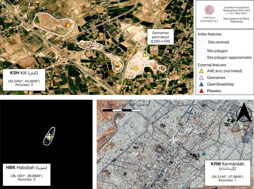
Cuneiform Digital Library Journal 2021:1 page 5 of 12Armenian (arm_name), Farsi (fas_name), Geor- toponyms. Where names in multiple languages gian (geo_name), Greek (gre_name), Hebrew are available, the transcribed name is drawn from (heb_name), and Russian (rus_name). A Ro- the official language of the national entity cur- manised version of the modern place-name rently associated with the record in question. (transc_name) is maintained from the original One should note that spelling of toponyms may when dealing with Azerbaijani, Maltese, Roma- vary, so discrepancies between the values given nian, or Turkish toponyms, or transcribed accord- in this index and those of other repositories will ing to the guidelines of the American Library As- occasionally occur. Values are derived from ar- sociation – Library of Congress (ALA-LC) (see chaeological reports or site gazetteers or, alter- https://www.loc.gov/catdir/cpso/roman.html) natively from online resources, e.g. Wikipedia, when dealing with Arabic, Armenian, Azerbai- OpenStreetMap, and Geonames. jani, Farsi, Georgian, Greek, Hebrew, or Russian Figure 1: A visualisation of spatial vector data associated with individual records in CIGS and the different levels of spatial accuracy for each record. Kiš (KSH, top left) is a typical mounded site with a well-defined topographical outline. The location and general outline of H . abūbah (HBK, bottom left), a mound now inundated by an artificial lake, is well known, but not accurately traceable on modern imagery. The modern city of Kirmānšāh (KRM, bottom right), while given as the presumed provenience of multiple inscriptions, cannot be meaningfully represented as an archaeological locale and so is given a representative point location only. All maps to scale. Background imagery courtesy of Bing Maps (www.bing.com/maps). page 6 of 12 Cuneiform Digital Library Journal 2021:1
§6. Usage                                            data frameworks for querying associated tem-
                                                     poral and spatial information will allow for ex-
§6.1 A provisional visualisation of the current ver- tended, formal analyses of a vastly increased
sion of this index (Fig. 1) neatly illustrates the number of variables than previously seen.
immense geographical spread of the cuneiform
script, from Rome to Kabul and from central Rus- §6.2 Our initial aim with the index introduced
sia to southern Egypt and the Strait of Hormuz. here is, however, more prosaic.             First and
Considering the comparatively high level of spa- foremost, we wish to introduce a measure of
tial and archaeological resolution, as well as the standardisation to text provenience information,
sheer scale, of this corpus, cuneiform holds sig- thereby allowing for the lasting and dynamic in-
nificant potential to decisively inform data-driven tegration of spatial information with digital re-
comparative studies on the emergence, spread, search tools and existing online text catalogues.
and use of writing in early human history (see The index combines a formal set of record iden-
for quantitative studies on long-term trends in tifiers and basic attribute data with accurate loca-
the production and consumption of writing, al- tional information generated according to a uni-
beit from much later periods, e.g. Buringh and form and easily reproducible set of procedures
van Zanden, 2009; Xu, 2013). Linking up exist- and allows for the linking of these entities with
ing digital text catalogues, such as those of the corresponding records in leading open access
CDLI, ORACC, and others, with versatile meta- geodata repositories.

Figure 2: Point distribution of the 553 location records contained in CIGS v. 1.2. Modern country
vector outlines courtesy of GADM v. 3.6 (www.gadm.org).

§6.3 Most pressing here is, of course, the need       ferent research projects, initiatives, and publica-
to adopt a formally sound and generally recog-        tions. The rise of crowdsourced or volunteer ge-
nised means of referencing locational data in as-     ographic information platforms over the last two
sociation with the study and safeguarding of          decades has brought with it an unrivalled wealth
cuneiform culture, a requirement that this in-        of locational information accessible to profession-
dex seeks to address by introducing a basic and       als and laypersons alike. These resources hold
universally applicable reference resource. As an      immense potential for the future integration and
example, comparable geographical indices have         free dissemination of spatial data by researchers,
been in widespread use in Mayan studies since         if recognising and helping to amend the emer-
the 1980s (Fash, 2016; Prager et al., 2014), offer-   gent need to generate and curate geographical in-
ing an easy and transparent way to identifying        formation with the same rigour as other types of
and referencing provenience locations across dif-     metadata (Goodchild 2008).

Cuneiform Digital Library Journal 2021:1                                                    page 7 of 12
building infrastructures for the digital rendering
§6.4 Similar sentiments underlie our inclusion of
of provenience metadata is a critical prerequisite
toponymical information in a wide variety of lan-
guages and scripts, and the adoption of a formalfor the future integration of research databases
means of transliteration into Roman letters. Thein cuneiform studies and archaeology. While the
exact rendering of many toponyms in cuneiform digital divide between these fields is understand-
able from an epistemological, and especially dis-
studies are a product firstly of the rich linguis-
tic landscape of the Middle East and adjoining ciplinary, point of view, it is lamentable never-
regions, secondly the myriad ways of naming, theless, even more so when considering the ur-
gent need for comprehensive digital infrastruc-
spelling, and rendering place names in native lan-
guages and scripts, and thirdly of the differenttures able to aid the safeguarding of cultural her-
orthographical conventions of various European itage in the Middle East and beyond. The in-
languages in which these toponyms have often ul-creased technological and computer-driven abili-
ties of archaeological research in the Middle East,
timately settled in the literature. By providing a
and here especially the emergence of extensive,
formal and digitally durable set of names for text
proveniences, we hope that this index will bringspatial databases, certainly represents one of the
some degree of order to the very confusing to- most obvious interfaces between textual and ma-
ponymical landscape that we ourselves have en- terial research going forward (Gates, 2020). We
countered. hope that researchers and cultural heritage pro-
fessionals alike will be able to make use of the re-
§6.5 Finally, and as noted in the introduction, source presented here in comparable ways.
page 8 of 12 Cuneiform Digital Library Journal 2021:1Value Field Type Description
Site ID key site_id str Primary ID. Each record is identified with a
unique three-letter code.
Locational accuracy accuracy int A formal assessment of the level of ge-
ographical accuracy with which position
given can be said to relate to the historical lo-
cation in question on a four-tier scale, 3 be-
ing certain, 2 being representative, 1 being
tentative, and 0 being unknown.
CDLI ID key cdli_provenience_id int The numerical provenience ID for the cor-
responding site in the Cuneiform Digital
Library Initiative (www.cdli.ucla.edu) cata-
logue, if available.
Ancient name anc_name str Common rendering of the ancient name of
the site in question, if known, based on read-
ings from cuneiform texts.
Transcribed name transc_name str The transcribed name of the site as drawn
from the principal language of the national
entity currently associated with the record in
question.
Arabic name ara_name str Arabic name of the site, if applicable and
available.
Armenian name arm_name str Armenian name of the site, if applicable and
available.
Farsi name fas_name str Farsi name of the site, if applicable and avail-
able.
Georgian name geo_name str Georgian name of the site, if applicable and
available.
Greek name gre_name str Greek name of the site, if applicable and
available.
Hebrew name heb_name str Hebrew name of the site, if applicable and
available.
Russian name rus_name str Russian name of the site, if applicable and
available.
Pleiades ID pleiades_id int The primary ID of the corresponding place
record in Pleiades: A Gazetteer of Ancient
Places, if available. The stable link will be
https://pleiades.stoa.org/places/[pleiades_id].
OpenStreetMap ID osm_id int The primary ID of the correspond-
ing place record in OpenStreetMap,
if available. The stable link will be
https://www.openstreetmap.org/[osm_type]/
[osm_id].
OpenStreet Map ge- osm_type str The geometry type of the corresponding
ometry type place record in OpenStreetMap, if available.
Cuneiform Digital Library Journal 2021:1 page 9 of 12Geonames ID geonames_id int The primary ID of the correspond-
ing place record in Geonames, if
available. The stable link will be
https://www.geonames.org/[geonames_id].
CDLI legacy value cdli_legacy str All associated legacy provenience val-
ues found in the current catalogue of
the Cuneiform Digital Library Initiative
(www.cdli.ucla.edu).
Longitude (x) lon_wgs1984 int Longitude of the record location in decimal
degrees in the WGS 1984 geographic coordi-
nate reference system (EPSG 4326).
Latitude (y) lat_wgs1984 int Latitude of the record location in decimal
degrees in the WGS 1984 geographic coordi-
nate reference system (EPSG 4326).
Table 1: Overview and explanation of data fields (CIGS v. 1.2).
page 10 of 12 Cuneiform Digital Library Journal 2021:1BIBLIOGRAPHY Avanzini, A., A. De Santis, and I. Rossi (2019). “Encoding, Interoperability, Lexicography: Digital Epig- raphy Through the Lens of DASI Experience”. In: Crossing Experiences in Digital Epigraphy, From Practice to Discipline. Ed. by I. Rossi and A. De Santis. Berlin & Boston: De Gruyter, 1–18. Bigot Juloux, V., A.R. Gansell, and A. Di Ludovico (2018). CyberResearch on the Ancient Near East and Neighboring Regions. Leiden & Boston: Brill. Buringh, E. and J.L. van Zanden (2009). “Charting the ‘Rise of the West’: Manuscripts and Printed Books in Europe, A Long-Term Perspective from the Sixth through Eighteenth Centuries.” The Jour- nal of Economic History 69, 409–445. Connolly, J. and M. Lake (2006). Geographical Information Systems in Archaeology. Cambridge: Cam- bridge University Press. Dahl, J. L. (2008). “The Proto-Elamite Writing System”. In: The Elamite World. Ed. by J. Álvarez-Mon, G.P. Basello, and Y. Wicks. London and New York: Routledge, 383–396. Dunnell, Robert C. and William S. Dancey (1983). “The Siteless Survey: A Regional Scale Data Collec- tion Strategy”. In: Advances in Archaeological Method and Theory 6. Ed. by Michael Schiffer. New York: Academic Press, 267–287. Ebert, C.E., K.M. Prufer, and D.J. Kennett (1999-2000). “Maya Monuments and Spatial Statistics: A GIS-Based Examination of the Terminal Classic Period Maya Collapse”. Research Reports in Belizean Archaeology 9, 91–105. Fash, B.W. (2016). Site Codes. Corpus of Maya Hieroglyphic Inscriptions. url: https : / / www. peabody. harvard.edu/cmhi/writing.php. Finkel, I. and J. Taylor (2015). Cuneiform. London: The British Museum. Gates, M.-H. (2020). “Archaeology and the Ancient Near East: Renewing a Culture-Historical Part- nership”. In: A Companion to the Ancient Near East, Blackwell Companions to the Ancient World. Ed. by D.C. Snell. ABAW NF 79. John Wiley & Sons, 74–93. Goodchild, M.F. (2007). “Citizens as sensors: the world of volunteered geography”. GeoJournal 69, 211–221. url: https://doi.org/10.1007/s10708-007-9111-y. – (2008). “Spatial Accuracy 2.0”. In: Proceedings of the 8th International Symposium on Spatial Accuracy Assessment in Natural Resources and Environmental Sciences. Gregory, I.N. and A. Geddes (2014). Toward Spatial Humanities: Historical GIS and Spatial History. Bloom- ington, IN: Indiana University Press. Harrison, T.P. (2018). “Computational research on the Ancient Near East (CRANE): large-scale data integration and analysis in Near Eastern archaeology”. Levant 52:1-2, 1–4. url: https://doi.org/10. 1080/00758914.2018.1492784. Huehnergard, J. and C. Woods (2008). “Akkadian and Eblaite”. In: The Ancient Languages of Mesopotamia, Egypt, and Aksum. Ed. by R.D. Woodard. Cambridge: Cambridge University Press, 83– 152. Kintigh, K. et al. (2014). “Grand Challenges for Archaeology”. American Antiquity 79, 5–24. Melchert, H.C. (2008a). “Luvian”. In: The Ancient Languages of Asia Minor. Ed. by R.D. Woodard. Cam- bridge: Cambridge University Press, 31–39. – (2008b). “Palaic”. In: The Ancient Languages of Asia Minor. Ed. by R.D. Woodard. Cambridge: Cam- bridge University Press, 40–45. Michalowski, P. (2008). “Sumerian”. In: The Ancient Languages of Mesopotamia, Egypt, and Aksum. Ed. by R.D. Woodard. Cambridge: Cambridge University Press, 6–46. Cuneiform Digital Library Journal 2021:1 page 11 of 12
Mohammed, N.Z., A. Ghazi, and H.E. Mustafa (2008). “Horizontal Positional Accuracy of Google
 Earth’s High-Resolution Imagery Archive”. Sensors 8, 7973–7981. url: https://doi.org/10.3390/
 s8127973.
– (2013). “Positional Accuracy Testing of Google Earth”. International Journal of Multidisciplinary Sci-
  ences and Engineering 4, 6–9.
Novotny, J. and K. Radner (2019). “Official Inscriptions of the Middle East in Antiquity: Online Text
 Corpora and Map Interface”. In: Crossing Experiences in Digital Epigraphy. Ed. by I. Rossi and A. De
 Santis. Warsaw: De Gruyter, 141–154.
Pardee, D. (2008). “Ugaritic”. In: The Ancient Languages of Syria-Palestine and Arabia. Ed. by R.D.
  Woodard. Cambridge: Cambridge University Press, 5–35.
Pedersén, O. (2012). “Ancient Near East on Google Earth: Problems, Preliminary Results, and
  Prospects”. In: Proceedings of the 7th International Congress on the Archaeology of the Ancient Near East
  12 April - 16 April 2010, the British Museum and UCL, London. Vol. 3: Fieldwork & Recent Research. Ed. by
  R. Matthews and J. Curtis. Wiesbaden: Harrassowitz, 385–393.
Peterson, L. (1994). “Scandinavian Runic-text Database: a Presentation”. In: The Twelfth Viking
  Congress: Developments Around the Baltic and North Sea in the Viking Age, Birka Studies. Ed. by B. Am-
  brosiani and H. Clarke. Stockholm, 305–309.
Prager, C. et al. (2014). A Checklist of Archaeological Sites with Hieroglyphic Inscriptions. url: https : / /
  mayawoerterbuch.de/archaeologicalsites/.
Rossi, I. and A. De Santis (2019). Crossing Experiences in Digital Epigraphy, From Practice to Discipline.
  Berlin & Boston: De Gruyter. url: https://doi.org/10.1515/9783110607208.
Schmitt, R. (2008). “Old Persian”. In: The Ancient Languages of Asia and the Americas. Ed. by R.D.
  Woodard. Cambridge: Cambridge University Press, 76–100.
Smith, M.E. et al. (2012). “Archaeology as a Social Science”. Proceedings of the National Academy of
  Sciences 109, 7617–7621.
Stolper, M.W. (2008). “Elamite”. In: The Ancient Languages of Mesopotamia, Egypt, and Aksum. Ed. by
  R.D. Woodard. Cambridge: Cambridge University Press, 47–82.
Streck, M.P. (2010). “Großes Fach Altorientalistik: Der Umfang des keilschriftlichen Textkorpus”. Mit-
  teilungen der Deutschen Orient-Gesellschaft 142, 35–58.
Walker, C.B.F. (1990). “Cuneiform”. In: Reading the Past: Ancient Writing From Cuneiform to the Alphabet.
 Ed. by J.T. Hooker. University of California Press and British Museum, 15–74.
Watkins, C. (2008). “Hittite”. In: The Ancient Languages of Asia Minor. Ed. by R.D. Woodard. Cambridge:
 Cambridge University Press, 6–30.
Wilhelm, G. (2008a). “Hurrian”. In: The Ancient Languages of Asia Minor. Ed. by R.D. Woodard. Cam-
 bridge: Cambridge University Press, 81–104.
– (2008b). “Urartean”. In: The Ancient Languages of Asia Minor. Ed. by R.D. Woodard. Cambridge:
  Cambridge University Press, 105–123.
Wright, H. and J.D. Richards (2018). “Reflections on Collaborative Archaeology and Large-Scale On-
 line Research Infrastructures”. Journal of Field Archaeology 43, 60–67. url: https://doi.org/10.1080/
 00934690.2018.1511960.
Xu, T. (2013). “Knowledge Formation and the Great Divergence between China and Europe:
  Manuscripts and Printed Books, ca. 581–1840”. Journal of Comparative Asian Development 12, 245–
  284. url: https://doi.org/10.1080/15339114.2013.792455.
Zerbini, A. (2018). “Developing a Heritage Database for the Middle East and North Africa”. Journal of
  Field Archaeology 43, 9–18. url: https://doi.org/10.1080/00934690.2018.1514722.

page 12 of 12                                                      Cuneiform Digital Library Journal 2021:1
You can also read